Flinders Fire Management Area
Bushfire Risk Management Plan
2021
←
→
Page content transcription
If your browser does not render page correctly, please read the page content below
Flinders Fire Management Area Bushfire Risk Management Plan 2021
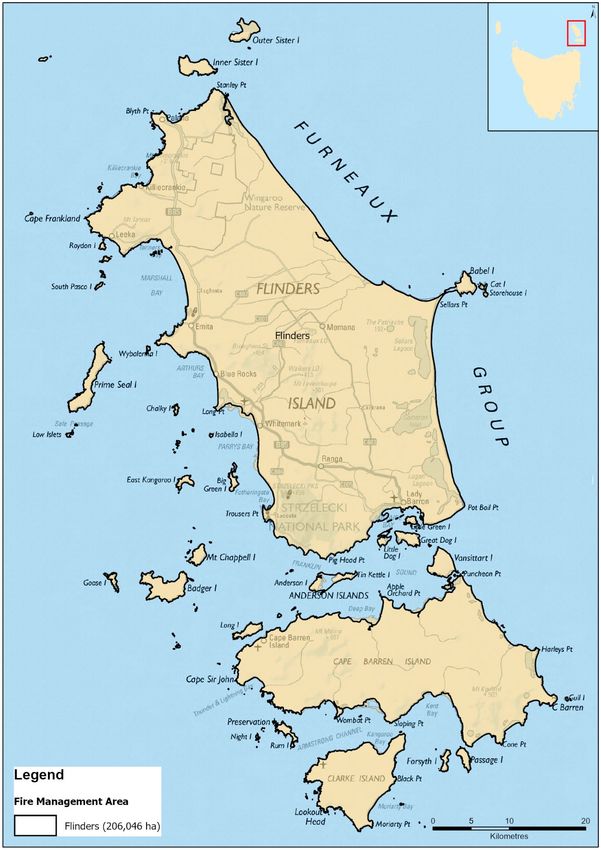
Document Control
Document History
 Version                  Date                   Author                  Section

 1.0                      February 2021          L Murray                Bushfire Risk Unit

Document Endorsements
 Agency                   Name & Title           Signature               Date

Document Endorsement by Flinders Fire Management Area Committee

Jacci Viney, Chair, Flinders FMAC

Date: 11/03/2021

Accepted by State Fire Management Council

Chair, SFMC

Date:

Cover Page Photo Acknowledgement: Lady Barron Fuel Reduction Burn, Courtesy: Rochelle Richards
Contents
Contents ...................................................................................................................................... 3
Glossary ....................................................................................................................................... 5
Acronyms ..................................................................................................................................... 7
Executive Summary ...................................................................................................................... 8
1.       Introduction ..................................................................................................................... 10
         1.1 Background ........................................................................................................................... 10
         1.2 Purpose of this plan .............................................................................................................. 10
2.       Establishing the context .................................................................................................... 12
         2.1 Description of the Flinders Island Fire Management Area ................................................... 12
         2.2 Fire environment................................................................................................................... 12
         2.3 Climate and bushfire season ................................................................................................. 14
         2.4 Population and community ................................................................................................... 15
         2.5 Community engagement....................................................................................................... 16
3.       Identifying the risks .......................................................................................................... 17
         3.1 Bushfire and impact scenarios .............................................................................................. 17
         3.2 Statewide controls ................................................................................................................ 17
         3.3 Fire Management Area controls ........................................................................................... 17
4.       Analysing and evaluating bushfire risk ............................................................................... 19
         4.1 Analysing bushfire risks ......................................................................................................... 19
         4.2 Evaluating bushfire risks ....................................................................................................... 19
5.       Bushfire risk treatment ..................................................................................................... 20
         5.1 Treatment plan...................................................................................................................... 20
         5.2 Bushfire management zones................................................................................................. 20
         5.3 Implementing treatments ..................................................................................................... 20
         5.4 Strategic fire infrastructure ................................................................................................... 21
         5.5 Fuel reduction burning .......................................................................................................... 21
6.       Monitoring and review ..................................................................................................... 22
         6.1 Review ................................................................................................................................... 22
         6.2 Monitoring and reporting ..................................................................................................... 22
References ................................................................................................................................. 23
Appendices ................................................................................................................................ 24
         Appendix 1: Risk register............................................................................................................. 24
         Appendix 2: Treatment plan ....................................................................................................... 28
         Appendix 3: Bushfire Management Zones .................................................................................. 31
         Appendix 4: Strategic Fire Trails.................................................................................................. 32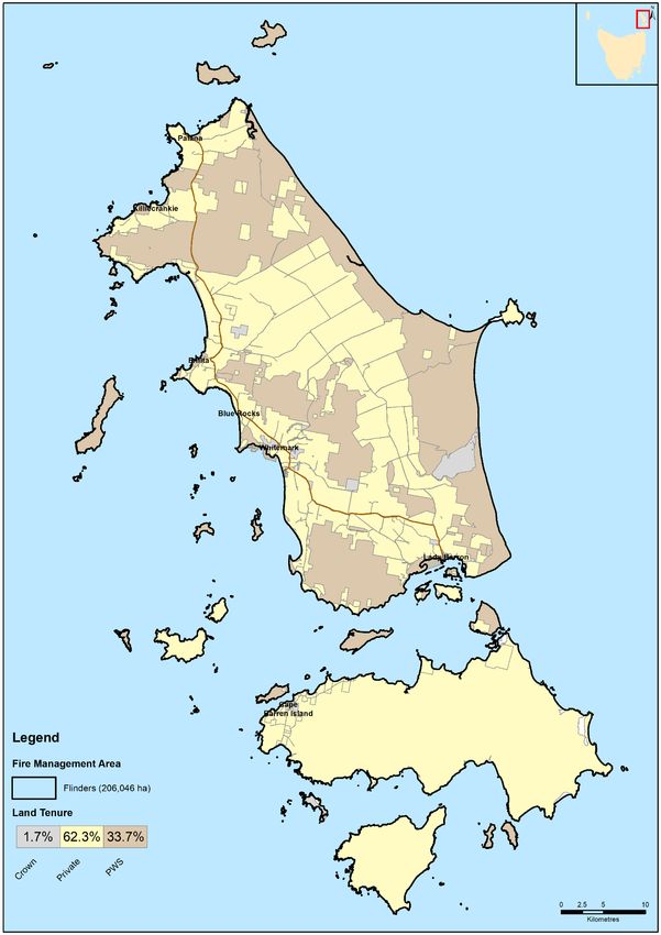
Appendix 5: Current implementation plans................................................................................ 33
Maps ........................................................................................................................................ 34
         Map 1: Flinders Fire Management Area location ....................................................................... 35
         Map 2: Tenure summary map for Flinders Fire Management Area ........................................... 36
         Map 3: Assets and values from the risk register for Flinders Fire Management Area ............... 37
         Map 4: Fuel treatability for Flinders Fire Management Area ..................................................... 38
         Map 5: Vegetation for Flinders Fire Management Area ............................................................. 39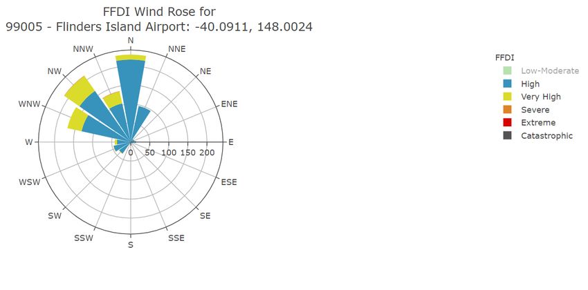
Glossary

Glossary
Asset                   A term used to describe anything valued by the community that may be adversely impacted
                        by bushfire. This may include houses, infrastructure, agriculture, production forests, industry,
                        and environmental and heritage sites.
Asset Zone (AZ)         The geographic location of asset(s) and values of importance requiring bushfire exclusion.
Asset Protection Zone   An area adjacent to or near Asset Zones, the primary management purpose of which is to
(APZ)                   protect human life, property and highly valued assets and values. Treatment can include
                        intensive fuel reduction, manipulation of fuel moisture or response plans.
Bushfire                Unplanned vegetation fire. A generic term which includes grass fires, forest fires and scrub
                        fires both with and without a suppression objective.
Bushfire hazard         The potential or expected behaviour of a bushfire burning under a particular set of
                        conditions, i.e. the type, arrangement and quantity of fuel, the fuel moisture content, wind
                        speed, topography, relative humidity, temperature and atmospheric stability.
Bushfire Risk           A computer-based modelling tool that uses a series of inputs to assess the risk of bushfire to
Assessment Model        a specific area. The BRAM has a capacity to produce a series of outputs. It was developed and
(BRAM)                  is managed by Tasmanian Parks & Wildlife Service.
Bushfire risk           A systematic process to coordinate, direct and control activities relating to bushfire risk with
management              the aim of limiting the adverse effects of bushfire on the community.
Community Bushfire      A bushfire plan for community members that provides local, community-specific information
Protection Plan         to assist with bushfire preparation and survival. The focus of the Bushfire Protection Plan is
                        on bushfire safety options, and the intent of the plan is to support the development of
                        personal Bushfire Survival Plans.
Community Bushfire      An Emergency Management Plan for emergency managers and responders. The Bushfire
Response Plan           Response Plan aims to better protect communities and their assets during bushfire
                        emergencies, through the identification of protection priorities and operational information.
Consequence             Impact(s) of an event on the five key areas: environment, economy, people, social setting and
                        public administration.
Control                 A measure that modifies risk. This may be an existing process, policy, device, practice or other
                        action that acts to minimise negative risk or enhance positive opportunities.
Fire management         Classification system for the areas to be managed. The zoning system indicates the primary
zoning                  purposes for fire management for an area of land.
Fuel break              A natural or manmade change in fuel characteristics which affects fire behaviour so that fires
                        burning into them can be more readily controlled.
Hazard management       The area between a building and the bushfire-prone vegetation that provides access to a fire
area                    front for firefighting, which is maintained in a minimal fuel condition and in which there are
                        no other hazards present that will significantly contribute to the spread of a bushfire.
Human Settlement        Term given for the dataset used to define where people live and work. The dataset was
Area                    developed for the purpose of risk modelling and was created using a combination of building
                        locations, cadastral information and ABS data. Includes seasonally populated areas and
                        industrial areas.
Land Management         An area that is managed to meet the objectives of the relevant land manager such as:
Zone (LMZ)              Traditional Owner practices, biodiversity conservation, production forestry, farming or
                        recreation. Management can include planned burning, experimental treatments, fire
                        exclusion or no planned action.
Likelihood              Chance of something happening. It is used as a general description of probability and may be
                        expressed qualitatively or quantitatively.
Risk register           A document usually presented in a tabular form which lists concisely the following
                        information for each risk: the risk statement, source, hazard, impact area,
                        prevention/preparedness controls, recovery/response controls, level of existing controls,
                        likelihood level, risk level, confidence level and treatment strategy.
Risk treatment          Process of selection and implementation of controls to modify risk. The term ‘risk treatment’
                        is sometimes used for the controls themselves.
                                                                                                               Page 5 of 39
                                                                                             Bushfire Risk Management Plan
Glossary

Strategic Fire         An area located close to or some distance away from assets (e.g. the urban–rural interface),
Management Zone        the primary management purpose of which is to provide a mosaic of areas of reduced fuel in
(SFMZ)                 strategic locations to reduce the speed and intensity of bushfires, potential for spot-fire
                       development, and size of bushfires. Treatment is by fuel reduction burning and other bushfire
                       protection measures such as fire trails, water points, detection measures and response plans.
Treatable vegetation   Types of vegetation which are suitable for fuel reduction burning, for example, dry eucalypt
                       forest, scrub, heathland and buttongrass.
Treatment plan         A document related to the risk register presented in a tabular form which lists concisely the
                       following information for each risk: the agreed strategies to manage the risk (i.e. treatments),
                       the responsible organisations, proposed completion date and comments.

                                                                                                             Page 6 of 39
                                                                                           Bushfire Risk Management Plan
Acronyms
Acronyms
BRMPG Bushfire Risk Management Planning Guidelines
BRAM Bushfire Risk Assessment Model
BRMP Bushfire Risk Management Plan
DPIPWE Department of Primary Industries, Parks, Water and Environment
FFDI Forest Fire Danger Index
FMA Fire Management Area
FMAC Fire Management Area Committee
LGA Local Government Area
PWS Parks and Wildlife Service
SFMC State Fire Management Council
STT Sustainable Timber Tasmania
TFS Tasmania Fire Service
Maps contained in this document may include data provided by DPIPWE (Land Tasmania), Parks and
Wildlife Service (Fire Management Section) and Tasmania Fire Service. These map products have been
produced by the Tasmania Fire Service. While all efforts have been taken to ensure their accuracy,
there may be errors and/or omissions in the data presented. Users of these products are advised to
independently verify data for accuracy and completeness before use.
Page 7 of 39
Bushfire Risk Management PlanExecutive Summary
Executive Summary
This Bushfire Risk Management Plan identifies priorities for the treatment of bushfire risk in the
Flinders Island Fire Management Area over the next three years. It was developed by the
Fire Management Area Committee (FMAC) as required under sections 18 and 20 of the
Fire Service Act 1979. This plan aims to coordinate and influence the treatment of bushfire risk in the
Fire Management Area.
The plan is strategic level and does not include all details of bushfire risk treatments; but does identify
which organisations or individuals are responsible for implementing them. The Flinders Island FMAC
will prepare a written report twice yearly for the State Fire Management Council on the progress of
implementation.
The plan was developed in line with the Bushfire Risk Management Planning Guidelines 2020. The risk
assessment considers bushfire impacts to the assets and values in the area, and uses the following
matrix to calculate a risk rating:
The results of the risk assessment are summarised in the risk register (Appendix 1) and the proposed
treatments are listed in the treatment plan (Appendix 2). All maps are published on the internet on
LISTmap, and hyperlinks to these can be found in the relevant locations in this plan.
The Flinders FMA consists of an area of approximately 206,046 hectares, extending approximately
10 kilometres from Wilson Promontory in Victoria to the North East tip of the Tasmanian mainland. An
archipelago of 52 islands, the largest Island is Flinders Island, followed by truwana/Cape Barren Island
and Clarke Island. More than half of the Flinders FMA is private freehold land tenure.
There is a mix of vegetation within the Flinders FMA which ranges from heaths, scrub and dry
woodlands through to dry sclerophyll forest interposed with wet sclerophyll forest gullies and remnant
rainforest on Mt Strzelecki and the Darling Range.
Flinders Island is home to approximately 900 residents, with a population increase in the warmer
months due to visitors and medium-term seasonal residents (known colloquially as ‘tocals’ or transient
locals). Visitors to the island usually seek an eco-tourism experience. The economy is mainly based on
agriculture and tourism. Agricultural, tourism, natural and cultural assets are highly valued by the
Flinders FMA community.
Page 8 of 39
Bushfire Risk Management PlanExecutive Summary
Some of the highest priority risk assets identified by the Flinders FMAC either have had previous
strategic mitigation plans developed and require review and some have not had plans developed to
date. It is envisaged strategic mitigation for the FMA in general will be undertaken/reviewed during
the life of this Plan to further augment risk mitigation activities. The highest risks identified in the FMA
are broadly defined as:
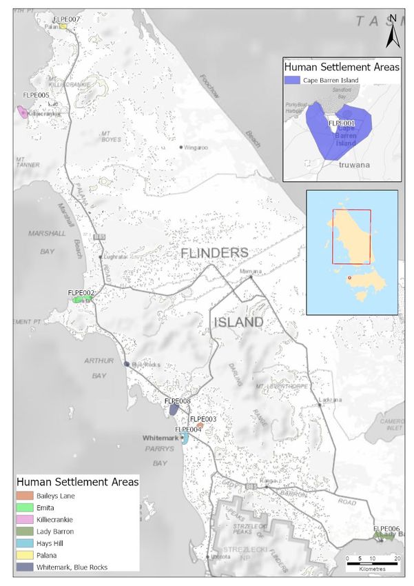
• The Human Settlement Areas of Lady Barron, Whitemark/Blue Rocks, Killiecrankie and The
Corner on truwana/Cape Barren Island. Fuel reduction is identified as a treatment for these
areas including fuel breaks and fuel reduction burning. The primary responsibility for conducting
these fuel reduction burns and fuel breaks are the Parks and Wildlife Service and Tasmania Fire
Service
• The historical site of Wybalenna. Discussions with the Aboriginal Land Council of Tasmania
(ALCT) will be required to determine the site’s values and how to mitigate bushfire risk
• Communications towers at Mt Tanner, Hays Hill and Walkers Lookout. Fuel reduction
opportunities
When further assets are identified, the FMAC will determine whether these assets require assessment
against the TERAG risk assessment process.
Page 9 of 39
Bushfire Risk Management PlanIntroduction
1. Introduction
1.1 Background
It is a requirement of Section 20 of the Fire Service Act 1979 that the Fire Management Area Committee
(FMAC) prepare a fire protection plan for its Fire Management Area. This Bushfire Risk Management
Plan (BRMP) fulfils that requirement. The BRMP is submitted to and approved by the State Fire
Management Council (SFMC).
The Fire Service Act 1979 requires that the fire protection plan is consistent with the State fire
protection plan, the Tasmanian Vegetation Fire Management Policy, and because it is an instruction
from SFMC, the Bushfire Risk Management Planning Guidelines (SFMC 2020).
The Bushfire Risk Management Planning Guidelines (BRMPG) explain the framework for bushfire risk
management in Tasmania, the method for doing the risk assessment, and how to prepare the BRMP.
There is very little explanation here in this plan on the rationale, principles and methods used;
therefore, the BRMPG is an important supporting document for understanding this plan.
Under the terms of reference for the Flinders Island FMAC, the purposes of the committee are:
• Provide a forum for communication and collaboration between key stakeholders in the FMA
• Enable a holistic and consistent approach, incorporating local knowledge, to identify strategic
priorities to reduce bushfire risk
• Coordinate efforts and facilitate resource sharing to implement the strategic risk reduction
priorities
• Link the local community and the SFMC through ‘ground-truthing’ the bushfire risk assessment
and mitigation strategies
• Through their advisory function, provide input into decisions and outcomes beyond the Fire
Management Area.
1.2 Purpose of this plan
The management of bushfire-related risk is a collective responsibility of the whole community, with
contributions made by numerous individuals, landowners and organisations.
An overriding aim of this BRMP is to document a coordinated approach to the identification and
treatment of bushfire risk in the Flinders Island Fire Management Area (FMA). Specific objectives
include:
• Guide and coordinate bushfire risk management over a three-year period on all land within the
FMA
• Provide a reference point for the prioritisation and justification of bushfire treatment actions,
as well as supporting evidence for funding requests
• Facilitate the integration of bushfire risk management into the business processes of councils,
organisations and land managers
• Facilitate cooperation and the coordination of treatment actions between stakeholders
• Clearly and concisely communicate bushfire risk to stakeholders and the community
• Provide a basis for monitoring and reporting of implementation of bushfire risk treatments in
the FMA.
Page 10 of 39
Bushfire Risk Management PlanIntroduction
This BRMP is a strategic-level document that does not provide detail on treatment actions. Individual
organisations and landowners, or collaborative groups, may have developed plans and processes for
implementation of bushfire risk treatment; these can be considered to be linked to the strategic
priorities identified here (SFMC 2020).
Page 11 of 39
Bushfire Risk Management PlanEstablishing the context
2. Establishing the context
2.1 Description of the Flinders Island Fire Management Area
The Flinders FMA consists of an area of approximately 206,046 hectares, extending approximately 10
kilometres from Wilson Promontory in Victoria to the North East tip of the Tasmanian mainland,
including the major land components of the Furneaux group, Hogan group and the Kent group of
Islands (map 1).
The Furneaux Group is an archipelago of 52 islands located in the Bass Strait between mainland
Australia and Tasmania. The largest Island is Flinders Island followed by truwana/Cape Barren Island
and Clarke Island.
The Flinders FMA covers the Flinders local government area (LGA). More than half of the Flinders FMA
is private freehold land tenure as shown in table 1 (map 2).
Table 1. Summary of the major tenure land managers in the Flinders Fire Management Area (FMA).
Land manager % of FMA
Private property 63
Parks and Wildlife Service reserves 35
Other 2
2.2 Fire environment
The vegetation of the Flinders FMA is complex. It is a mix, ranging from heaths, scrub and dry
woodlands through to dry sclerophyll forest interposed with wet sclerophyll forest gullies and remnant
rainforest on Mt Strzelecki and the Darling Range. Phytophthora cinnamomi (dieback) and peat soils
are also present in within the Flinders FMA.
The region is considered important biogeographically as it is indicative of an ecotone between the
Tasmanian and mainland vegetation complexes. Some of the vegetation species present on the Islands
are at the most southern point of its range if a mainland species or the most northern aspect of
Tasmanian endemic species.
The vegetation can also be categorised into broad groups that represent broad vegetation or landscape
types (Kitchener & Harris, 2013), as summarised in table 2 and map 6. The majority of vegetation
groups in the Flinders FMA are of high to very high flammability classes with a low to moderate
sensitivity to fire (Pyrke and Marsden-Smedley, 2005). Rainforest complexes on Mt Strzelecki and
Melaleuca ericifolia swamp forest scattered around the Island are sensitive to fire.
Page 12 of 39
Bushfire Risk Management PlanEstablishing the context
Table 2: Vegetation groups and flammability present within the Flinders FMA as a percentage of
FMA total area.
Vegetation Group (Kitchener & Harris, Flammability (Pyrke & % FMA
2013) Marsden-Smedley 2005)
Scrub, Heathland and Coastal Complexes High – very high 41.0
Agricultural, Urban and Exotic Vegetation Moderate 24.9
Dry Eucalypt Forest and Woodland Moderate - high 14.1
Non-Eucalypt Forest and Woodland Moderate 6.5
Native Grassland High 3.2
Saltmarsh and Wetland Low 3.4
Other Natural Environments Moderate 3.1
Moorland, Sedgeland, Rushland and Moderate - high 0.4
peatland
Rainforest and Related Scrub Low 0.1
The vegetation can also be considered in terms of its “treatability” with regards to fuel reduction
program burning (map 5). Treatable fuels suitable for fuel reduction burns are typically dry eucalypt
forest, scrub complexes, heath complexes and button grass. Agricultural lands while susceptible to the
impact of bush fires are not considered treatable due to the nature of the land use. However, this does
not preclude agricultural land from being incorporated into burning operations. Most fuels within the
Flinders FMA are treatable.
Prior to major settlement within the Flinders FMA, lightning strikes were assumed to be a cause of
ignition. Available records show that there are various causes of ignitions for bushfires in the Flinders
FMA. These causes include accidental ignitions, lightning, deliberate lighting of vegetation and escapes
from planned burns.
Previous fire incidents have been located near communities or in an agricultural landscape. Table 3
displays the major bushfires that have occurred within the Flinders FMA since 1990.
Table 3: Major fires Flinders Island FMA
Fire Name Ignition Date Area (ha)
Sellers Point 1990 578
Darling Range 2003 17,058
Cameron Lagoon 2003 4,261
Reedy Lagoon 2006 1,716
Cape Barren Island (Apple Orchard Point) 2006 39,760
Five Mile Road 2008 6,690
Clarke Island 2013 8,100
Page 13 of 39
Bushfire Risk Management PlanEstablishing the context
Fire Name Ignition Date Area (ha)
Lackrana Road 2016 4,641
Thunder and Lightning Bay, Cape Barren Island 2016 31,770
Foo Chow Conservation Area 2019 2736
Bushfires within the Flinders FMA are wind driven, with predominantly north westerly wind directions
on bad fire danger days during summer. Changes of wind direction are also commonly observed due
to localised weather patterns which can lead to erratic fire behaviour.
The presence of flammable fine fuels (i.e. coastal vegetation) and peat soils influences fire behaviour.
The undulating landscape within the Flinders FMA also playing a role due to the influence of slope on
fire behaviour.
2.3 Climate and bushfire season
The Flinders FMA experiences a climate that can be considered a mixture of a Mediterranean and an
oceanic climate that is composed of warm dry summers and mild wet winters. Under the moderating
influences of low elevation and the maritime effects, the Islands generally have a milder climate
compared to that of Tasmania, with rainfall possible in all seasons.
The Flinders FMA is also in the path of the “roaring forties” winds. Weather stations exist at the Flinders
Island airport and on Hogan Island. Figures 1 and 2 identify how the most common winds correlate
with Fire Danger Ratings (FDR) and historical Forest Fire Danger Indices (FFDI) for the last 30 years.
Figure 1: Wind Rose Plot for Forest Fire Danger Index (FFDI) – Flinders Island Airport
Page 14 of 39
Bushfire Risk Management PlanEstablishing the context
Figure 2: Forest Fire Danger Index (FFDI) and Annual Exceedance Probability (AEP) – Flinders Island
Airport
Fire seasons and prescribed burning seasons vary geographically and temporally. The fire season is
traditionally from November through to March though fires can and do occur outside this peak period
and fires can range from forest to grass fires.
Fuel reduction burning usually occurs in the seasonal months of autumn or spring, contingent on
suitable weather conditions, soil and fuel moisture, and controls being in place. Within the Flinders
FMA, cultural cool season burning has also occurred to some extent (particularly on Cape Barren
Island) in addition to traditional fuel reduction burning activities.
Climate is changing in Tasmania and it is evident from bushfire climate indicators (Fox-Hughes et al.
2015) that we can expect destructive bushfires to become more frequent.
2.4 Population and community
The estimated resident population of the Flinders Island is approximately 900 people. The population
increases in the warmer months due to a seasonal influx of visitors and residents (transient locals).
Visitors are usually seeking an eco-tourism experience.
A smaller population of approximately 90 persons reside on truwana/Cape Barren Island. The outer
Islands have transient populations based around agricultural needs and Mutton-bird season.
The community profile of the Flinders FMA indicates that there is a lower proportion of youth (0-17
years) and a higher proportion of persons at post retirement (+60 years). There is also, a strong
aboriginal presence and culture within the Flinders FMA, particularly on truwana/Cape Barren Island.
On Flinders Island there are two major population centres, Whitemark and Lady Barron. These centres
are home to the Island’s primary built environment and facilities, residential properties, businesses,
and industrial properties, with Whitemark being the administrative and commercial centre for the
Furneaux region. Other settlement areas include Emita, Palana, Memana, Lackrana, Killiecrankie and
Badger Corner/Ranga.
Page 15 of 39
Bushfire Risk Management PlanEstablishing the context
Outside the settlement areas, the population is based around Flinders farm holdings. Holiday homes
are scattered throughout Flinders Island, utilised as short-term accommodation.
The economy is based mainly on agriculture and tourism. Agricultural assets are based mainly on the
eastern side of the Island while the western and southern areas are dominated by residential villages
and nature-based tourism activities such as bushwalking, bird watching, flora/fauna research and
boating activities.
2.5 Community engagement
It is anticipated that there will be further community engagement by the Flinders FMAC with the wider
FMA community on topics not limited to fuel treatments, the role of the FMAC, risk assessment and
cultural cool burning practices. A community public education/awareness event is proposed as a
medium for engagement.
Engagement with the Cape Barren Island Aboriginal Association, the truwana rangers and other
relevant parties (e.g. farmers/farm managers) regarding fuel reduction via cool season burning on
Flinders and outer islands is expected.
It is also anticipated that there be continued engagement between FMAC agencies in order to discuss
funding and the implementation of treatments e.g. Flinders Council and other relevant agencies to
combine the need for fire trails with that of walking tracks.
Community engagement has previously been undertaken by the Bushfire Ready Neighbourhoods with
the communities of Lady Barron, Emita, The Corner (truwnana/Cape Barren Island), Killiecrankie,
Palana, West End, Blue Rocks, Big River and Whitemark.
Page 16 of 39
Bushfire Risk Management PlanIdentifying the risks
3. Identifying the risks
3.1 Bushfire and impact scenarios
To set the scene for this risk assessment, the bushfire scenarios under consideration are very large
events, typically 10,000 to 20,000 hectares, occurring when fuel dryness and weather conditions
combine to create one or more days of very significant fire weather. Analysis of climate data was used
to determine standard weather events for the scenarios – described as having an Annual Exceedance
Probability of approximately 10% (SFMC 2020). An example of a bushfire scenario is:
Dry lightning on a day of FFDI 46 ignites fuels on Mount Tanner, a bushfire spreads and destroys the
communications tower, with subsequent on and off island impacts. The fire also impacts the townships
of Whitemark and Emita
3.2 Statewide controls
The following controls are currently in place across Tasmania to help manage bushfire-related risk:
• Legislative controls – including Fire Service Act 1979 (e.g. Fire permit period, Total Fire Ban days,
campfires), National Parks and Reserves Management Act 2002 (e.g. fires and campfires),
abatement notices
• TFS public education (e.g. Bushfire Ready Neighbourhoods, media campaigns)
• TFS planning – community protection planning (e.g. Community Protection and Response Plans)
• Fuel Reduction Program (TFS, PWS, STT) – funding and coordination of fuel reduction burning
• SFMC programs (e.g. Red Hot Tips training program for fuel reduction burning on private land)
• FMAC – performance monitoring and reporting on this BRMP
• Tasmania Police and TFS – Statewide arson prevention programs
• Land subdivision and building standards (Bushfire-Prone Areas Code, Building Code of Australia)
• Suppression response preparedness – e.g. TFS local volunteer brigades, STT and PWS crews,
forest company crews, fire towers, aircraft, pre-positioning of firefighting resources
• Weather forecasting (Bureau of Meteorology) and fire behaviour prediction (TFS, STT, PWS)
3.3 Fire Management Area controls
Summary of existing control measures for bushfire within FMA include but are not limited to:
• Situational awareness during high FDR days, through alerts and warnings to the community
• 5 brigades on Flinders and 1 on Cape Barren Island
• Fire appliances:
o truwana/Cape Barren Island: 1 x 4.1 appliance; and
o Flinders: PWS (2 x 6.1); TFS (3 x 3.1; 2 x 4.1; 3 x 5.1; 1 x 3.1 Flinders Island Aboriginal
Association; and other private appliances)
• Fuel reduction burning, undertaken by the Fuel Reduction Program by TFS and PWS. Recent
burns including Vinegar Hill, the Flinders Island Airport (partial completion) and Lady Barron
Water Treatment Plant (partial completion)
• Cape Barren cultural burning at Chimney Hill
• Fire trail at Darling Range (Class 5 standard)
Page 17 of 39
Bushfire Risk Management PlanIdentifying the risks
• Strategic roads (links to trails and potential control lines). Five Mile road, Cameron Inlet road,
Logan Lagoon road, Summers road and Memana Road to Patriarchs Inlet
• Previous community engagement programs, including Bushfire Ready Neighbourhoods,
community development opportunities, and support for bushfire recovery
• PWS Reserve closures on bad fire days
• Slashing of road verges by the relevant authority
• Community Preparedness Planning initiatives through the development of Bushfire Protection
Plans and Bushfire Response Plans; and
• TFS Bushfire mitigation plans.
Page 18 of 39
Bushfire Risk Management PlanAnalysing and evaluating bushfire risk
4. Analysing and evaluating bushfire risk
4.1 Analysing bushfire risks
A standard risk assessment process was used to determine priorities for this Bushfire Risk Management
Plan (BRMP) following the Tasmanian Emergency Risk Assessment Guidelines and the Bushfire Risk
Management Planning Guidelines (SFMC 2020), which in summary considers:
• Consequences – what values and assets are at risk given the standard bushfire scenario under
consideration
• Existing controls – how effective the existing controls are at reducing the risk and how much
they are used
• Likelihood – how the likelihood of the consequence occurring is quantified, based on weather,
topography, fuels and ignition potential
• Confidence level – how certain we are about the evidence and data used
• Risk rating and priority score – calculated by the risk assessment tool (SFMC 2020).
All of the above are recorded in the risk register (Appendix 1).
4.2 Evaluating bushfire risks
High priority assets have been identified across a range of values and are outlined in the risk register
(Appendix 1).
Critical infrastructure and supporting network facilities for communication, power and water fall
within the general area of high priority assets but may not be individually identified for priority
actioning to review bushfire risk. Further analysis of these assets and their risk may be assessed as
they are identified.
High priority communities (namely Whitemark/Blue Rocks, Lady Barron, Killiecrankie, Emita and The
Corner) and the historical site of Wybalenna will be assessed at a strategic level to identify
opportunities for fuel treatments and fire infrastructure in the future. Further detailed analysis may
follow should key stakeholders determine local mitigation plans be required for these
settlements. Existing Bushfire Response Plans will be reviewed for some communities identified as
being at high risk to assist with decision making during bushfires (see Appendix 2).
Environmental values have been evaluated with consideration to vulnerability to bushfire and relative
impact. These values will be regularly re-analysed during the life of this Plan.
In addition to the implementation of strategic planned fuel reduction burns guided by the priorities
developed within the risk register (Appendix 1), consideration has been given to increased return
intervals for fuel reduction planned burning within strategic fire management zones determined by
fire practitioners.
Page 19 of 39
Bushfire Risk Management PlanBushfire risk treatment
5. Bushfire risk treatment
5.1 Treatment plan
The Fire Management Area Committee (FMAC) considered the costs, benefits, practicalities and
environmental impacts of various control options for the highest priority risks. The risk treatments that
were determined from these deliberations are recorded in the treatment plan (Appendix 2).
Individual landowners and organisations are usually responsible for implementing the treatments e.g.
Emergency Management Plans, insurance etc. and these are indicated in the treatment plan.
Exceptions are fuel reduction burning, fuel breaks etc. that are planned and conducted by the Fuel
Reduction Program (TFS, PWS, STT) with the agreement of landowners.
Some treatments include:
• Developing/reviewing strategic fire management plans for the FMA. This may include
development of a strategic fire management plan for Flinders Island and review of the existing
mitigation plan for truwana/Cape Barren
• Developing a continuing burn and fuel break program for identified human settlement and other
values
• Further analysis of risks to communication and other assets
• Consideration of existing/potential fire trails
• Developing/reviewing Response Plans to aid decision making during incidents
• Identifying/assessing potential Nearby Safer Places
• Community education through the Bushfire Ready Neighbourhoods program when the program
has capacity.
5.2 Bushfire management zones
For those assets and values where fuel management or other treatments are designated in the
treatment plan (Appendix 2), bushfire management zones are used to delineate the treatment areas.
The names of zones and descriptors are provided in Appendix 3.
5.3 Implementing treatments
This Bushfire Risk Management Plan (BRMP) does not guarantee a source of funding for treatment
actions, nor does it provide a process for seeking funding. The organisations and individuals that are
responsible for delivering the bushfire risk treatments are responsible for developing further plans for
implementation, as well as arranging resources and funding.
The BRMP is, however, intended to provide evidence and justification for where funding and resources
are most appropriate to be committed by stakeholders to mitigate bushfire risk.
Many treatments identified in this plan will require environmental and cultural impact assessment.
These assessments are the responsibility of the individual organisations and are not covered by this
BRMP.
Page 20 of 39
Bushfire Risk Management PlanBushfire risk treatment
Not all Human Settlement Areas or other assets are able to have a treatment applied to them. It is
however considered that many will benefit from treatments applied to nearby assets. Notable
decisions to not directly apply treatments/not determine treatments at this time include:
• Not to actively note the treatments beyond Priority Two for natural values in this FMA
• The decision to monitor and review risk to the Human Settlement Areas of Baileys Lane
(incorporating the Flinders Island High School) and Palana which were judged by the FMAC as
lower risks than the other assets identified in this plan
• The decision not to identify discrete fire trails. Further analysis of potential fire trails will be
undertaken in the strategic planning for the Island with analysis concentrating on what trails
may be affordable and achievable during the life of this Plan.
5.4 Strategic fire infrastructure
The strategic fire trail in the Flinders Island FMA is primarily under the ownership of the Parks and
Wildlife Service is listed in strategic fire trails (Appendix 4). This fire trail is designated because it is
essential for fuel reduction and bushfire suppression; it should be regularly maintained to appropriate
standards. Further analysis to determine potential strategic fire trails will be undertaken in more
detailed fire management plans.
5.5 Fuel reduction burning
The Strategic Fire Management Zones (SFMZ) delineate general areas for treatment by fuel reduction
burning. Individual burn units are not identified in this BRMP but will need to be identified within the
SFMZ by further planning from the organisations responsible for carrying out the fuel reduction
burning.
There are many kinds of vegetation for which it is not appropriate or practical to conduct fuel reduction
burning (SFMC 2020); these vegetation communities are described as ‘untreatable’ and indicated on
Map 4. The broad vegetation communities within the FMA can be seen on Map 5.
The Fuel Reduction Program that is funded, coordinated and implemented by the Tasmania Fire
Service, Parks and Wildlife Service and Sustainable Timbers Tasmania is undertaken on behalf of and
with the agreement of individual landowners or organisations (e.g. councils). The priorities of the Fuel
Reduction Program are guided by the priorities identified in the treatment plans across all Fire
Management Areas.
Page 21 of 39
Bushfire Risk Management PlanMonitoring and review
6. Monitoring and review
6.1 Review
This Bushfire Risk Management Plan (BRMP), including appendices and maps, will be subject to a
comprehensive review every three (3) years from the date of approval, unless significant
circumstances exist to warrant earlier review. The revised BRMP will be based on a new risk
assessment that may include revised input methods. The review process will include examination of:
• changes to the Fire Management Area (FMA), organisational responsibilities or legislation
• changes to the bushfire risk in the area
• major bushfire events
• shortcomings in data that can be improved
• change of usage of the area
• new or changed asset values within the FMA.
Additional and changed data and values (both community and natural) identified by the review process
will be supplied to the Bushfire Risk Unit (TFS) for inclusion in ongoing risk modelling being carried out
at the state level.
6.2 Monitoring and reporting
Progress towards completion of the treatments proposed will be monitored and reviewed twice a year
by the Fire Management Area Committee (FMAC); this will be documented in the Implementation
Status Report which should address as a minimum:
• progress on implementation of treatments listed in the treatment plan, including
• planning outcomes including mitigation plans, community protection plans, community
response plans
• implementation progress of community programs
• completed fuel reduction burns
• development and maintenance of Asset Protection Zones (APZ)
• development and maintenance of strategic fire infrastructure
At a Statewide level, the State Fire Management Council will examine the impacts of the strategic
burning program on risk management as part of the strategic fuel management program.
Page 22 of 39
Bushfire Risk Management PlanReferences
References
Fox-Hughes, P., Harris, R.M.B., Lee, G., Jabour, J., Grose, M.R., Remenyi, T.A. and Bindoff, N.L. (2015).
Climate Futures for Tasmania future fire danger: the summary and the technical report, Antarctic
Climate & Ecosystems Cooperative Research Centre, Hobart, Tasmania. Retrieved from
http://acecrc.org.au/wp-content/uploads/2015/12/Report_CFT_Future-Fire-Technical-
Report_2015_web.pdf.
TERAG (2017), Tasmanian Emergency Risk Assessment Guidelines. Department of Police, Fire and
Emergency Management, Tasmania. Retrieved from http://www.ses.tas.gov.au/about/risk-
management/terag/
SFMC (2020), Bushfire Risk Management Planning Guidelines, State Fire Management Council,
Tasmania. Retrieved from
http://www.sfmc.tas.gov.au/sites/sfmc.tas.gov.au/files/Bushfire%20Risk%20Management%20Planni
ng%20Guidelines%202020.pdf
Page 23 of 39
Bushfire Risk Management PlanAppendices
Appendices
Appendix 1: Risk register
Notes at the end of the risk register provide explanation for the TERAG code, Asset description and Priority FMAC columns.
TERAG Asset Asset description (risk Consequence Controls Confidence Combined Risk level Priority Treatment LGA
code category statement) effectiveness likelihood FMAC options
FLSO001 Aboriginal Wybalenna Major Low Highest Rare High 19 Flinders
Heritage
FLPU003 Critical Mount Tanner communication Moderate Very Low Highest Unlikely Medium 24 Flinders
Infrastructure tower
FLPU002 Critical Walkers Lookout Moderate Low Highest Unlikely Medium 24 Flinders
Infrastructure communication tower
FLPU001 Critical Hays Hill communication tower Moderate Low Highest Unlikely Medium 26 Flinders
Infrastructure
FLPE006 Human Lady Barron Minor Low Highest Unlikely Low 27 Flinders
Settlement
Area
FLPE003 Human Baileys Lane Insignificant Very Low Highest Unlikely Low 28 Flinders
Settlement
Area
FLPE001 Human Cape Barren Island Minor Medium Highest Unlikely Low 28 Flinders
Settlement
Area
FLPE005 Human Killiecrankie Minor Low Highest Unlikely Low 28 Flinders
Settlement
Area
FLPE008 Human Whitemark, Blue Rocks Minor Low Highest Unlikely Low 28 Flinders
Settlement
Area
FLPE002 Human Emita Minor Low Highest Rare Low 30 Flinders
Settlement
Area
FLPE004 Human Hays Hill Minor Very Low Highest Rare Low 30 Flinders
Settlement
Area
Page 24 of 39
Bushfire Risk Management PlanAppendices
TERAG Asset Asset description (risk Consequence Controls Confidence Combined Risk level Priority Treatment LGA
code category statement) effectiveness likelihood FMAC options
FLPE007 Human Palana Minor Low Highest Very Rare Very Low 32 Flinders
Settlement
Area
FLEN001 Natural Value Cloud, Engaeus, Remnant Major Very Low Highest Unlikely High 11 Flinders
rainforest
FLEN006 Natural Value Engaeus, Melaleuca Major Very Low Highest Unlikely High 11 Flinders
FLEN002 Natural Value Cloud, Engaeus Major Very Low Highest Unlikely High 13 Flinders
FLEN003 Natural Value Melaleuca Moderate Very Low Highest Unlikely Medium 24 Flinders
FLEN008 Natural Value Melaleuca Moderate Very Low Highest Unlikely Medium 24 Flinders
FLEN012 Natural Value Melaleuca Moderate Very Low Highest Unlikely Medium 24 Flinders
FLEN018 Natural Value Melaleuca Moderate Very Low Highest Unlikely Medium 24 Flinders
FLEN019 Natural Value Melaleuca Moderate Very Low Highest Unlikely Medium 24 Flinders
FLEN004 Natural Value Melaleuca Moderate Very Low Highest Unlikely Medium 26 Flinders
FLEN009 Natural Value Melaleuca Moderate Very Low Highest Unlikely Medium 26 Flinders
FLEN010 Natural Value Melaleuca Moderate Very Low Highest Unlikely Medium 26 Flinders
FLEN011 Natural Value Melaleuca Moderate Very Low Highest Unlikely Medium 26 Flinders
FLEN013 Natural Value Melaleuca Moderate Very Low Highest Unlikely Medium 26 Flinders
FLEN016 Natural Value Melaleuca Moderate Very Low Highest Unlikely Medium 26 Flinders
FLEN017 Natural Value Melaleuca Moderate Very Low Highest Unlikely Medium 26 Flinders
FLEN020 Natural Value Melaleuca Moderate Very Low Highest Unlikely Medium 26 Flinders
FLEN022 Natural Value Melaleuca Moderate Very Low Highest Unlikely Medium 26 Flinders
FLEN005 Natural Value Melaleuca Moderate Very Low Highest Rare Medium 29 Flinders
FLEN014 Natural Value Melaleuca Moderate Very Low Highest Rare Medium 30 Flinders
FLEN015 Natural Value Melaleuca Moderate Very Low Highest Rare Medium 30 Flinders
FLEN007 Natural Value Melaleuca Moderate Very Low Highest Rare Medium 31 Flinders
FLEN021 Natural Value Melaleuca Moderate Very Low Highest Very Rare Low 32 Flinders
FLEN023 Natural Value Melaleuca Moderate Very Low Highest Very Rare Low 32 Flinders
FLEN024 Natural Value Melaleuca Moderate Very Low Highest Very Rare Low 32 Flinders
FLEC001 Production PC_rad_5t Moderate Very Low Highest Unlikely Medium 24 Flinders
Forest
Page 25 of 39
Bushfire Risk Management PlanAppendices
Notes
TERAG Code
First and second characters identify the FMAC: CN = Central North; EC = East Coast; FL = Flinders; HO =
Hobart; KI = King Island; MI = Midlands; NE = North East; SO = Southern; TA = Tamar; WC = West Coast.
Third and fourth characters identify the Impact Area: EC = Economy; EN = Environment; PE = People; PU =
Public Administration; SO = Social setting (exception – all Human Settlement Areas are coded PE for
Economy).
A unique identifier is provided by the final three digits.
Asset Description (Risk Statement)
Natural value description is a list of the first word of each mapped natural value included in the cluster, in
other words, a shorthand summary. The following table provides a key, although reference to the bushfire
biodiversity consequence layer in the LISTmap Common Operating Platform is required to distinguish
duplicate descriptors (e.g. Eucalyptus = Eucalyptus morrisbyi or Eucalyptus gunnii ssp divaricata).
Descriptor Mapping unit name
Acanthornis Acanthornis magna greeniana King Island scrub tit
Allanaspides Allanaspides hickmani Hickman's pygmy mountain shrimp in Buttongrass moorland
Antipodia Antipodia chaostola Chaostola skipper butterfly
Austrochloritis Austrochloritis victoriae southern hairy red snail and Lavinia threatened species complex
Bryobatrachus Bryobatrachus nimbus moss froglet
Castiarina Castiarina insculpta Miena jewel Beetle
Central Central Plateau unburnt ecosystem
Central Central Plateau recovering ecosystem
Cloud Cloud forest refugia
Coniferous Coniferous rainforest
cushion cushion moorland
Discocharopa Discocharopa vigens ammonite Pinwheel Snail
Engaeus Engaeus martiniger Furneaux Burrowing Crayfish
Eucalyptus Eucalyptus morrisbyi Morrisbys gum
Eucalyptus Eucalyptus gunnii ssp divaricata Miena cider gum
Giant Giant Trees over 90
Giant Giant Trees under 90
Highland Highland coniferous heath
Hoplogonus Hoplogonus bornemisszai Bornemisszas Stag Beetle
King King Island Eucalyptus globulus King Island blue gum
Lissotes Lissotes latidens Broad toothed stag beetle
Lomatia Lomatia tasmanica King’s lomatia
Neophema Neophema chrysogaster orange bellied parrot
Nothofagus Nothofagus gunnii deciduous beech
Palaeo Palaeo endemic species catastrophic
Palaeo Palaeo endemic species major
Phebalium Phebalium daviesii Davies wax flower
Pherosphaera Pherosphaera hookeriana drooping pine
Pneumatopteris Pneumatopteris pennigera lime fern
Regenerating Regenerating rainforest large patches
Remnant Remnant rainforest
Sphagnum Sphagnum
Tetratheca Tetratheca gunnii shy pinkbells
TWWHA TWWHA Very Tall Forest over 70 refugia
Melaleuca Melaleuca ericifolia swamp forest
Notelaea Notelaea Pomaderris Beyeria forest
Oreisplanus Oreisplanus munionga larana Marrawah skipper butterfly
Oreixenica Oreixenica ptunarra ptunarra brown butterfly
Palaeo Palaeo endemic species moderate
Tasmanian Tasmanian devil facilities
TWWHA TWWHA Very Tall Forest over 70
Page 26 of 39
Bushfire Risk Management PlanAppendices
Priority FMAC
The priority FMAC column has been calculated based on risk ratings and likelihood calculated across the
entire state for all assets and values considered together. Therefore some numbers may be missing and it is
the rank order that is relevant.
Page 27 of 39
Bushfire Risk Management PlanAppendices
Appendix 2: Treatment plan
Notes at the end of the risk register provide explanation for the TERAG code, Asset description and Priority FMAC columns.
TERAG Asset description Priority Treatment Treatment Treatment action detail Bushfire Responsible Completion Comment
code (risk statement) FMAC number category management organisation date proposed
zone
FLPU003 Mount Tanner 24 1 Fuel reduction Continue with fuel APZ TFS, consult PWS ongoing Local Mitigation Plan to
communication reduction program follow if strategic
tower assessment deems it
necessary
FLPU002 Walkers Lookout 24 2 Fuel reduction Development of Flinders APZ TFS, consult PWS 1/10/2021
communication Island Strategic Mitigation
tower Plan
FLPU001 Hays Hill 26 2 Fuel reduction Development of Flinders APZ TFS, consult PWS 1/10/2021
communication Island Strategic Mitigation
tower Plan
FLPE006 Lady Barron 27 2 Fuel reduction Development of Flinders TFS, consult PWS 1/10/2021 Local Mitigation Plan to
Island Strategic Mitigation follow if strategic
Plan assessment deems it
necessary. Existing
Mitigation Plan could be
basis for local strategy.
Speak further to PWS re
potential burns/breaks
FLPE006 Lady Barron 27 3 Fuel reduction Continue with fuel APZ TFS ongoing Continue existing burn
reduction program program subject to
appropriate opportunities,
weather and resources
FLPE006 Lady Barron 27 4 Fuel reduction Establish and maintain AZ TasWater ongoing
Asset Protection Zones
around Taswater assets
FLPE006 Lady Barron 27 5 Fuel reduction Investigate mitigation AZ Finders Council ongoing
options for waste station
site
FLPE006 Lady Barron 27 6 Preparedness Review Lady Barron TFS 1/04/2023
Response Plan
FLPE003 Baileys Lane 28 7 Accept risk Monitor and review DHHS ongoing School may wish to consider
protection of water tanks
Page 28 of 39
Bushfire Risk Management PlanAppendices
TERAG Asset description Priority Treatment Treatment Treatment action detail Bushfire Responsible Completion Comment
code (risk statement) FMAC number category management organisation date proposed
zone
FLPE001 Cape Barren Island 28 8 Fuel reduction Review truwana/Cape SFMZ TFS 1/10/2021 Existing Mitigation Plan due
Barren Island Mitigation for review
Plan
FLPE001 Cape Barren Island 28 9 Fuel reduction Continuation of fuel break APZ CBIAA ongoing Continue with fuel breaks as
maintenance identified in existing
Mitigation Plan
FLPE001 Cape Barren Island 28 10 Fuel reduction Establish and maintain AZ TasWater ongoing As per existing Mitigation
Asset Protection Zones Plan
around Taswater assets
FLPE005 Killiecrankie 28 2 Fuel reduction Development of Flinders TFS, consult PWS 1/10/2021 Local Mitigation Plan to
Island Strategic Mitigation follow if strategic
Plan assessment deems it
necessary.
FLPE005 Killiecrankie 28 11 Fuel reduction Continue with fuel SFMZ TFS/PWS ongoing Continue existing burn
reduction program program subject to
appropriate opportunities,
weather and resources
FLPE005 Killiecrankie 28 12 Preparedness Review Killiecrankie Area TFS 1/10/2022
Response Plan
FLPE008 Whitemark, Blue 28 2 Fuel reduction Development of Flinders TFS, consult PWS 1/10/2021 Local Mitigation Plan to
Rocks Island Strategic Mitigation follow if strategic
Plan assessment deems it
necessary.
FLPE008 Whitemark, Blue 28 13 Fuel reduction Continue with fuel APZ TFS Continue existing burn
Rocks reduction program program subject to
appropriate opportunities,
weather and resources
FLPE008 Whitemark, Blue 28 14 Preparedness Review Whitemark TFS 1/04/2022
Rocks Response Plan
FLPE002 Emita 30 2 Fuel reduction Development of Flinders PWS, TFS 1/10/2021 Local Mitigation Plan to
Island Strategic Mitigation follow if strategic
Plan assessment deems it
necessary. PWS to develop
mitigation options for Emita
including to east of
settlement.
Page 29 of 39
Bushfire Risk Management PlanAppendices
TERAG Asset description Priority Treatment Treatment Treatment action detail Bushfire Responsible Completion Comment
code (risk statement) FMAC number category management organisation date proposed
zone
FLPE002 Emita 30 15 Preparedness Review Emita Response TFS
Plan
FLPE004 Hays Hill 30 2 Fuel reduction Development of Flinders TFS, consult PWS 1/10/2021 Local Mitigation Plan to
Island Strategic Mitigation follow if strategic
Plan assessment deems it
necessary.
FLPE004 Hays Hill 30 16 Fuel reduction Investigate protection of AZ Hydro ongoing Assess values at risk,
critical infrastructure and determine what mitigation
ongoing maintenance of activities are appropriate
power station
FLPE004 Hays Hill 30 17 Fuel reduction Investigate options for AZ Flinders Council ongoing Previous plan refers to
waste station site 'removal, other…'
FLPE004 Hays Hill 30 18 Fuel reduction Establish and maintain AZ TasWater ongoing
Asset Protection Zones
around Taswater assets
FLPE007 Palana 32 19 Accept risk Monitor and review TFS ongoing Palana represents a lower
risk than other HSAs at this
time. Monitor and review
during the life of this plan.
Page 30 of 39
Bushfire Risk Management PlanAppendices
Appendix 3: Bushfire Management Zones
Zone Primary purpose General location Risk treatments
Asset Zone (AZ) To identify assets and values The physical boundary of the Building design elements such as:
requiring bushfire exclusion. asset. fire-resistant materials, ember
proofing, sprinklers, water storage
etc.
Response plans.
Asset Protection To protect human life, property Adjacent to Asset Zones or Intensive bushfire fuel treatment
Zone (APZ) and highly valued assets and elements in the landscape around specific assets and the
values. that can be used to this urban–rural interface to provide a
effect. Width determined by fuel reduced buffer. May include
characteristics of the asset both burning and mechanical fuel
and the bushfire hazard reduction. Includes Hazard
(effective slope, vegetation Management Areas.
type). This zone may Manipulation of fuel moisture (e.g.
encompass multiple land sprinklers), response plans.
tenures.
Strategic Fire To provide areas of reduced Located close to or some Fuel reduction burning, including
Management fuel in strategic locations, to distance away from assets broad-scale fuel treatment.
Zone (SFMZ) reduce the: (e.g. the urban–rural Management should aim to achieve
• speed and intensity of interface). Identified fire mosaic fuel reduction patterns. Fire
bushfires paths inform the location and intervals and intensity generally do
delineation of the zone. not exceed ecological thresholds.
• potential for spot-fire
development Other bushfire protection measures
to assist bushfire control: fire trails,
• size of bushfires. water points, detection measures,
To aid containment of response plans.
bushfires.
Land To meet the objectives of the Any bushland areas outside Various, but can include planned
Management relevant land manager such as: the above zones. burning, experimental treatments,
Zone (LMZ) Traditional Owner practices, fire exclusion or no planned action.
biodiversity conservation,
production forestry, farming,
research or recreation.
Page 31 of 39
Bushfire Risk Management PlanYou can also read