PLYMOUTH'S LOCAL CYCLING AND WALKING INFRASTRUCTURE PLAN - (2021) OFFICIAL - Plymouth City Council
←
→
Page content transcription
If your browser does not render page correctly, please read the page content below
OFFICIAL

  PLYMOUTH’S LOCAL
  CYCLING AND WALKING
  INFRASTRUCTURE PLAN
  (2021)

                 1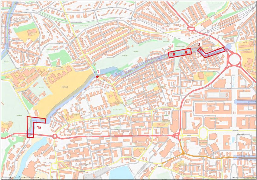
OFFICIAL

  FOREWORD

  As a Council we are committed to encouraging and enabling more trips to be made on foot and by bike.
  We recognise the benefits of increased levels of walking and cycling. For residents it means cheaper travel
  and better health. For businesses, increased productivity, and for society as a whole; lower congestion,
  better air quality, and vibrant, attractive places and communities.

  Our walking and cycling strategy is set out in the Plymouth Plan. We have made a commitment to deliver a
  safe, accessible, sustainable and health enabling transport system 1 that delivers a step change in walking,
  cycling and public transport as the travel modes of choice for those living in and visiting the city. 2 We have
  said that we will make sure that transport is delivered in the most health promoting and environmentally
  responsible manner, 3 where the impact of severance caused by transport networks is reduced, enabling
  more journeys by walking, cycling and public transport and providing genuine alternative ways to travel 4.
  To do this we have adopted a hierarchy of modes and routes based upon different spatial settings, 5 with
  walking and cycling being the best option for local trips.

  Our strategy mirrors the national policy set out in the statutory Cycling and Walking Investment Strategy
  (CWIS) 6 and accords with Governments vision articulated in the Gear Change Report 7.

  Plymouth City Council has a strong track record of investing in active travel. Between 2016 and 2020 we
  invested £8.95 million in walking and cycling infrastructure. This funding has delivered improvements along
  NCN 27 along Finnigan Road and past TR2, and also an extension of the route along the railway alignment
  east of Laira Rail Bridge to serve the Saltram Meadow development. Whilst in the north of the city, the
  first part of a route that will connect Southway to Plymbridge has recently been constructed.

  In addition a further £58M has been secured through the Transforming Cities Fund (TCF). The
  programmes to be delivered through Tranche 2 of the TCF will improve the facilities available for
  pedestrians and cyclists on the Northern and Western Corridors, and city centre, through infrastructure
  schemes, and will also encourage and enable more trips to be made on foot and by bike through the
  delivery of mobility hubs and workplace travel grants.

  This investment, alongside complementary programmes such as Plymotion, have allowed us to make
  significant progress in increasing levels of active travel in Plymouth. Department for Transport counts
  across the city show more than a 70% increase in cycling in the last 10 years, from 2009 to 2019 using a
  two-year rolling average. However, there is still much more to be done and strategic investment, achieved
  through the delivery of the routes identified within our LCWIP and on our Strategic Cycle Network
  (SCN), will support the City’s aspiration to boost active travel still further, to support the sustainable
  development of the City, it’s recovery post Covid-19 and achievement of our Climate Emergency pledge.

  1
    Plymouth Plan Policy HEA6.
  2
    Plymouth Plan – Theme 2: A Green City.
  3
    Plymouth and South West Devon Joint Local Plan policy SPT9.1.
  4
    Plymouth and South West Devon Joint Local Plan Policy SPT9.4.
  5
    Plymouth and South West Devon Joint Local Plan Policy SPT9.8.
  6
    DfT: Cycling and Walking Investment Strategy, April 2017.
  https://assets.publishing.service.gov.uk/government/uploads/system/uploads/attachment_data/file/918442/cycling-walking-
  investment-strategy.pdf.
  7
    Gear Change. A bold vision for cycling and walking, July 2020.
  https://assets.publishing.service.gov.uk/government/uploads/system/uploads/attachment_data/file/904146/gear-change-a-
  bold-vision-for-cycling-and-walking.pdf.

                                                              2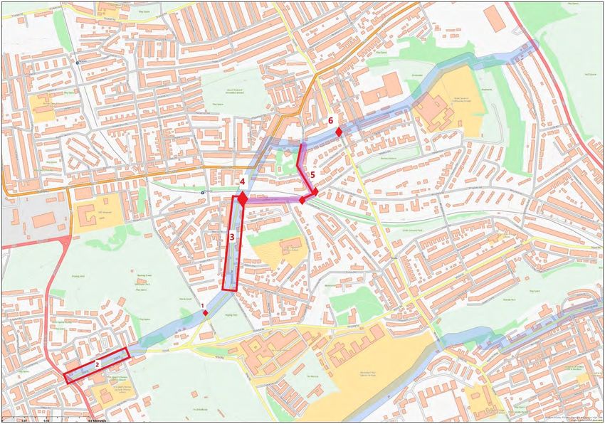
OFFICIAL

  Our commitment to walking and cycling is further demonstrated by this Local Cycling and Walking
  Infrastructure Plan.

  Councillor Jonathan Drean, Cabinet Member for Transport

                                                     3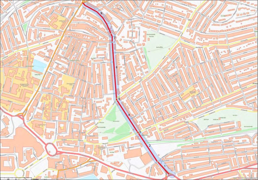
OFFICIAL

  TABLE OF CONTENTS

  1.0 WHAT IS A LOCAL CYCLING AND WALKING INFRASTRUCTURE PLAN?.................... 6
     1.1 WHAT’S INCLUDED IN AN LCWIP? ................................................................................................................................... 6

     1.2 WHY ARE THEY IMPORTANT? .......................................................................................................................................... 6

     1.3 WHAT’S THE PROCESS FOR DEVELOPING AN LCWIP? ..................................................................................................... 7

  2.0 PLYMOUTH’S LCWIP................................................................................................. 7
     2.1 STAGE ONE - Scope .......................................................................................................................................................... 7

     2.2 STAGE TWO - Gathering Information .............................................................................................................................. 8

     2.3 STAGE THREE - Network Planning for Cycling ................................................................................................................. 8

     2.3.1 Cycle Route One ......................................................................................................................................................... 19

     2.3.2 Cycle Route Two ......................................................................................................................................................... 21

     2.3.3 Cycle Route Three....................................................................................................................................................... 23

     2.3.4 Cycle Route Four......................................................................................................................................................... 25

     2.4 STAGE FOUR - Network Planning for Walking ............................................................................................................... 29

     2.4.1 Walking Route One ..................................................................................................................................................... 36

     2.4.2 Walking Route Two..................................................................................................................................................... 38

     2.4.3 Walking Route Three .................................................................................................................................................. 40

     2.4.4 Walking Route Four .................................................................................................................................................... 42

     2.4.5 Walking Route Five ..................................................................................................................................................... 44

     2.4.6 Walking Route Six ....................................................................................................................................................... 46

     2.5 STAGE FIVE – Prioritising Improvements ....................................................................................................................... 48

     2.6 STAGE SIX - Integration and Application ....................................................................................................................... 48

  GLOSSARY ............................................................................................................... 49

                                                                                           4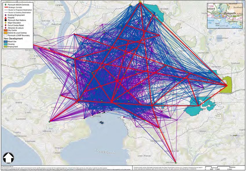
OFFICIAL

  TABLE OF FIGURES

   Figure                                          Title            Page
                                                                    No.
      1     Cycling origin-destination analysis and key corridors    10
      2     Key cycling corridors and PCT outputs                    12
      3     Strategic cycling routes                                 14
      4     Network prioritisation                                   16
      5     Audited Cycle Routes                                     18
      6     Cycling route one – Recommendation locations map         20
      7     Cycling route two – Recommendation locations map         22
      8     Cycling route three – Recommendation locations map       25
      9     Cycling route four – Recommendation locations map        29
     10     City centre core walking zone                            31
     11     Key walking routes into Plymouth City Centre             33
     12     Audited walking routes                                   35
     13     Walking route one - Recommendation locations map         38
     14     Walking route two - Recommendation locations map         40
     15     Walking route three - Recommendation locations map       42
     16     Walking route four - Recommendation locations map        44
     17     Walking route five - Recommendation locations map        46
     18     Walking route six - Recommendation locations map         48

  TABLE OF TABLES

   Table                                           Title            Page
                                                                    No.
     1      Audited cycle routes                                     17
     2      Cost categorisation                                      19
     3      Audited walking routes                                   36

                                                    5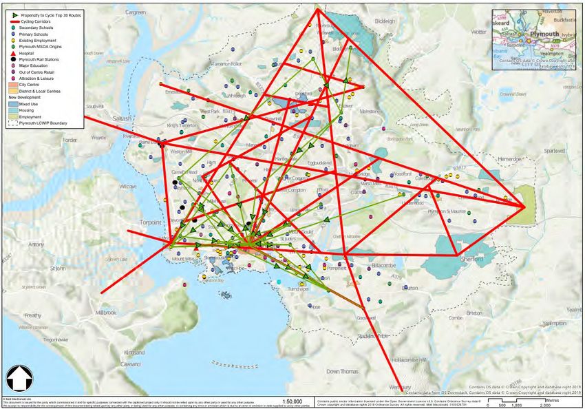
OFFICIAL

  1.0 WHAT IS A LOCAL CYCLING AND WALKING
  INFRASTRUCTURE PLAN?
  A Local Cycling and Walking Infrastructure Plan (LCWIP) is a plan identifying cycling and walking
  improvements needed to increase levels of active travel.

  They are included in the action plan of the statutory, national, Cycling and Walking Investment Strategy
  (CWIS) which was published in April 2017. The Strategy sets out the Government’s ambition to make
  cycling and walking the natural choice for shorter journeys, or as part of a longer journey, with the aim of
  doubling cycling, increasing walking activity and increasing the percentage of children aged 5 to 10 that
  usually walk to school from 49% (2014) to 55% by 2025.

  1.1 WHAT’S INCLUDED IN AN LCWIP?
  An LCWIP should include:
       • a network plan for walking and cycling which identifies preferred routes and core zones for
       further development
       • a prioritised programme of infrastructure improvements for future investment
       • a report which sets out the underlying analysis carried out and provides a narrative which
       supports the identified improvements and network.

  An LCWIP does not include specific designs for proposed interventions, detailed financial information or
  timeframes for delivery nor does an LCWIP set out supporting behaviour change interventions which,
  alongside infrastructure investment, can help to maximise increases in walking and cycling. In Plymouth
  behavioural change interventions are delivered through Plymotion.

  1.2 WHY ARE THEY IMPORTANT?
  By taking a strategic approach to improving conditions for cycling and walking, LCWIPs are intended to
  help:-
          • identify cycling and walking infrastructure improvements for future investment in the short,
          medium and long term
          • ensure that consideration is given to cycling and walking within both local planning and transport
          policies and strategies
          • make the case for future funding for walking and cycling infrastructure.

                                                        6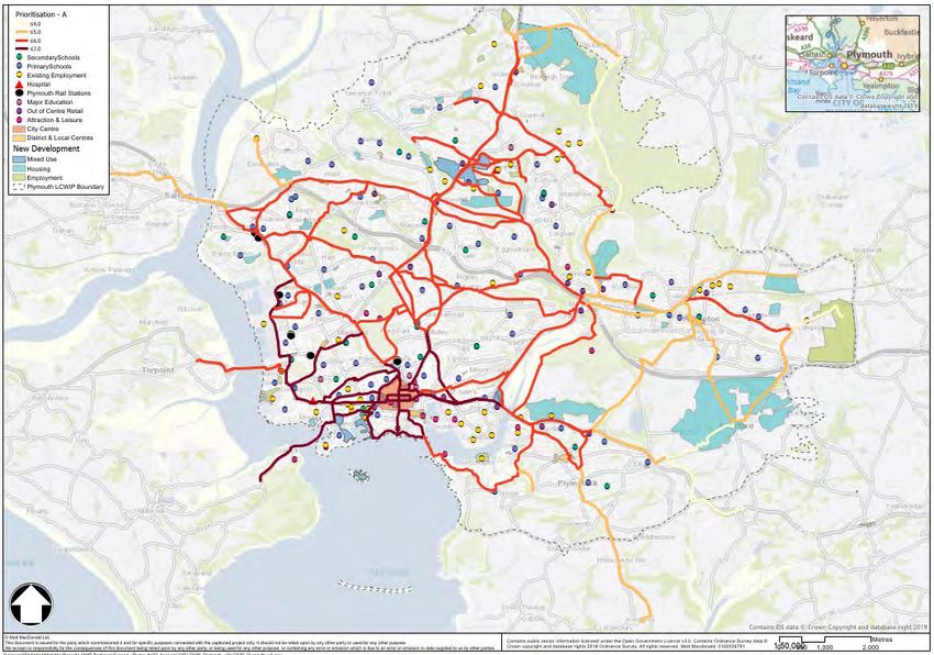
OFFICIAL

  1.3 WHAT’S THE PROCESS FOR DEVELOPING AN LCWIP?
  The development of an LCWIP involves six stages. These are:-

  Plymouth’s LCWIP has been developed in accordance with these stages.

  2.0 PLYMOUTH’S LCWIP

  2.1 STAGE ONE - Scope: - The geographical extent of Plymouth’s LCWIP is the Plymouth
  Policy Area (PPA) of the Joint Local Plan.

  The PPA incorporates the administrative area of Plymouth along with Plymouth’s Urban Fringe. Locations
  that are part of the wider urban area (e.g. Woolwell, Langage) and where major development is committed
  (e.g. the new community at Sherford), as well as the city's landscape setting, fall within this policy area.

  It was chosen as the boundary of the LCWIP because of the potential for walking and cycling trips in this
  area; the LCWIP technical guidance identifies the potential for cycling to replace trips by other modes for
  distances up to 10km (although some people will cycle greater distances), with walking distances being
  circa 2km.

  Due to the size of the area within the PPA Plymouth’s LCWIP will be phased, with the intention being to
  add new routes each year, as demonstrated by action 2.15 within the Councils second Climate Emergency
  Action Plan (CEAP 2) which commits the Council to expand the LCWIP to include five more cycling
  routes identified as having the greatest potential to increase cycling, should the route be enhanced.

  This is the Council’s first LCWIP.

                                                       7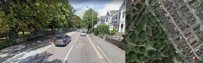
OFFICIAL
2.2 STAGE TWO - Gathering Information
The LCWIP guidance suggests collecting information on the following:
• transport network – including planned and proposed transport and land use schemes;
• travel patterns – information from the Propensity to Cycle Tool (PCT) and locations of existing
origins and trip attractors;
• location of significant trip generators; and
• perception of existing facilities.
To represent residential locations (or origins) within Plymouth, Middle Layer Super Output Area (MSOA)
population weighted centroids (a point at the population centre of the area) within the PPA boundary, and
within 5km of the boundary, were extracted from the national dataset.
Committed allocated housing developments were also included in the Geographic Information System
(GIS) to be used as additional origin points for the LCWIP. This information is essential to understand
potential future flows, which is especially important for new settlements.
The following ‘destinations’ were included in the analysis:
• employment and mixed-use developments;
• key employment areas (business parks, industrial estates);
• the city centre;
• district & local centres;
• major out of centre retail;
• major education facilities (such as universities and large colleges);
• leisure and attractions;
• major hospitals (with A&E departments); and
• transport interchanges (bus, rail and ferry ports).
People’s perceptions of the existing facilities will be obtained as part of the consultation on the LCWIP
routes with comments helping to inform the design of the infrastructure enhancements.
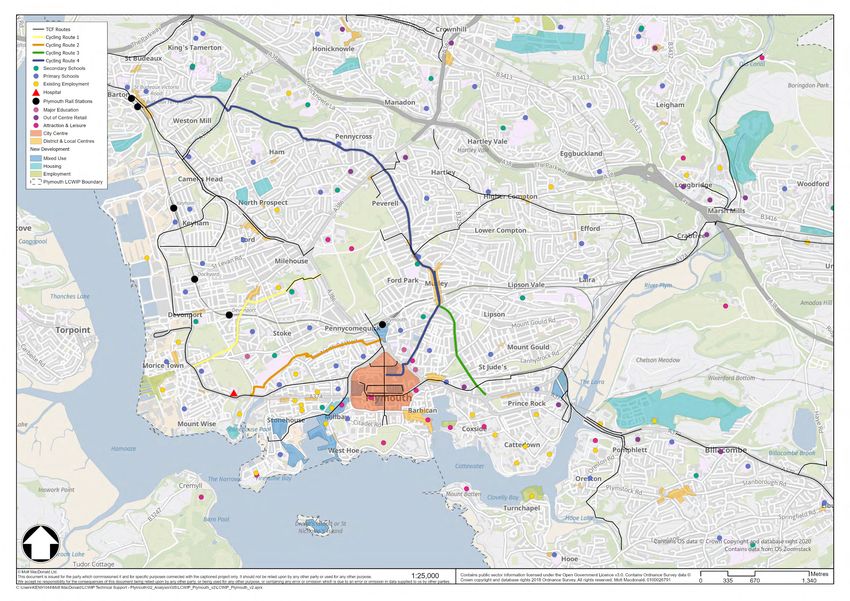
2.3 STAGE THREE - Network Planning for Cycling
Plymouth City Council has a Strategic Cycle Network (SCN). It is a city plan detailing the network of key
cycling routes that we aim to create in the coming years, adopted unanimously by Full Council as part of
the Local Transport Plan, and most recently refreshed as part of the development of the Plymouth and
South West Devon Joint Local Plan.
The SCN has been developed through stakeholder engagement and is designed to support experienced
and inexperienced cyclists, including child cyclists.
The network is colour-coded with the faster purple routes (which involve dealing with traffic) for
experienced cyclists and the slower but safer green routes for less experienced and leisure cyclists and
children. Where the purple and green routes meet they'll be developed so that they're suitable for all
cyclists.
8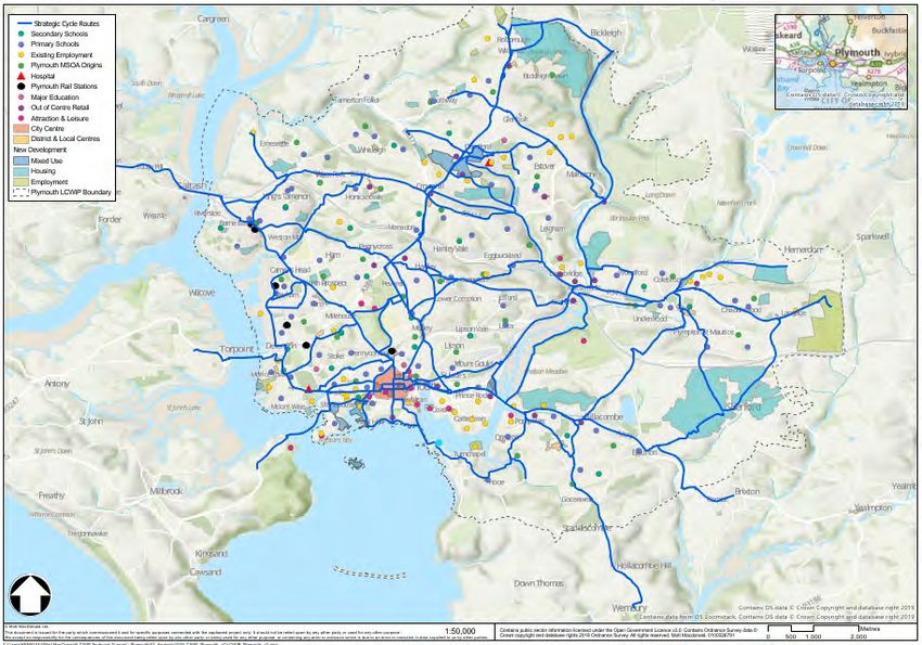
OFFICIAL

  The LCWIP looks to complement the SCN and start to progress the auditing of key routes and the initial
  identification of potential infrastructure improvements.

  For the LCWIP, origin-destination analysis was undertaken in a GIS to understand the routes which cyclists
  are likely to take between origins and destinations, in order to identify corridors of high demand.

  Primarily, a set of core rules were created as to which origins connect to which destinations, the rules are
  as follows:

     •   Every origin will connect to every destination within 5 kilometres (representing approximately a 20-
         minute cycle), excluding: district centres, retail centres and hospitals – for each of these
         destinations each origin is connected to the closest of each category of destination (within 5km).

  The analysis was completed using the Network Analyst extension of ArcMap. The output is a straight line
  between every origin-destination pair which connected on the road and paths network in under 5km (with
  the exception of district centres, retail centres and hospitals as outlined above). From this analysis, key
  corridors, or trends, were identified. The result of the analysis and the key corridors are shown in Figure
  One.

  The purple lines indicate the routes between existing origins to existing destinations. The blue lines show
  potential future routes between new housing developments and existing destinations, or existing origins
  and new employment sites.

                                                        9
OFFICIAL

           FIGURE 1: CYCLING ORIGIN-DESTINATION ANALYSIS AND KEY CORRIDORS
                                                                             10
OFFICIAL
In order to sense check the key corridors identified from this analysis the Propensity to Cycle Tool (PCT)
government target scenario straight line data was loaded into GIS, showing the top 30 routes in the study
area (Figure Two).
The output from the PCT shows some common cycling corridors, but there are also additional routes
which had not been previously identified. The PCT is limited to census travel to work data only, whereas
the key corridors identified also include leisure and education trips, which explains why the corridors are
not all the same.
11OFFICIAL
FIGURE 2: KEY CYCLING CORRIDORS AND PCT OUTPUTS
12OFFICIAL
The corridors identified by the origin-destination analysis were mapped to the road network. Each
corridor was routed on the road and path network along the fastest possible route. The routes were then
merged together to form a network. This was then checked and revised using local knowledge. The output
is shown in Figure Three.
13OFFICIAL
FIGURE 3: STRATEGIC CYCLING ROUTES
14OFFICIAL
Due to the large number of routes identified, the network was prioritised (subjected to multi-criteria
analysis) to identify the highest priority routes, to be taken forward first.
Prioritisation was based on:-
• Proximity to Air Quality Management Areas (AQMAs);
• Indices of Multiple Deprivation (IMD) – at LSOA level;
• Proximity to primary schools;
• Proximity to secondary schools;
• Proximity to higher education;
• Economic – proximity to employment (existing and proposed), out of centre retail, attractions,
local/district centres, town centre, mixed use development;
• Proximity to PCT routes scenario; and
• Proximity to planned housing development.
The network shown in Figure Three was split into links (between junctions). Using spatial analysis, each
link was given a score for each dataset. The score from all eight datasets was added together, giving each
link a total score out of eight. The result is shown in Figure Four.
15OFFICIAL
FIGURE FOUR: NETWORK PRIORITISATION
16OFFICIAL
The highest scoring sections (shown in darker colours in Figure Four) were then extracted. As these sections were generally quite small, they were extended
to form routes. This was undertaken by selecting the next highest priority section adjacent to the ‘top’ sections, and continuing this to either the study area
boundary, or a logical end point.
The sections which form part of the TCF corridors were not included as part of the routes as interventions had already been identified for them.
The top four routes (Table 1 and Figure 5) were identified and audited. The routes were audited using the Route Selection Tool (RST), which scores routes
based on five core design outcomes for cycling, which are: coherent, direct, safe, comfortable and attractive.
Table 1: Audited cycle routes
Route Junction of A374 (Park Avenue / Chapel Street) and Fore Street - Devonport - and the junction of A386 (Alma Road) and
One Ponsonby Road – Stoke
East - west cycle route connecting the walking and cycling routes ‘Dockyard – City Centre’ and the ‘Somerset Place to Ponsonby Road’ [1] being
delivered as part of the Council’s Productive Plymouth Transforming Cities Fund programme.
The route is within 400m of the following potential ‘mobility hub’ locations which are being considered as part of the Transforming Cities Fund
Mobility Hub programme: Devonport Station; Granby Way; Devonport Cumberland Road; City Centre; Plymouth Life Centre.
Route Junction of A374 (Devonport Hill) and Kings Road – Devonport – to junction of A386 (Saltash Road) and North Road West
Two (Plymouth Railway Station) – Stonehouse.
East - west cycle route connecting the walking and cycling routes ‘Dockyard – City Centre’ and the Plymouth Station forecourt scheme being
delivered as part of the Council’s Productive Plymouth Transforming Cities Fund programme. The route also passes through the North
Stonehouse Quiet Neighbourhoods, Connected Community for the length of North Road West.
The route is within 400m of the following potential ‘mobility hub’ locations which are being considered as part of the Transforming Cities Fund
Mobility Hub programme: Plymouth Central Station.
Route Junction of B3238 and Cattedown Roundabout - Cattedown- to Mutley Plain (end of Greenbank Road).
Three
North – south cycle route connecting the community of Cattedown with the Mutley Plain district centre. The route is bordered to the south
by the Council’s proposed Cattedown Roundabout Major Road Network (MRN) scheme.
The route is within 400m of the following potential ‘mobility hub’ locations which are being considered as part of the Transforming Cities Fund
Mobility Hub programme: Friary Retail Park.
Route Eastlake Street/Cornwall Street via Fleetmoor Road and Mutley Plain to St Budeaux Wolseley Road.
Four
North – south cycle route connecting the communities of St Budeaux, King’s Tamerton, Ham, Pennycross and Peverell with the City Centre,
connecting the walking and cycling route ‘Dockyard – City Centre’ and the ‘Better Places Plymouth’ scheme being delivered as part of the
Council’s Productive Plymouth Transforming Cities Fund programme
The route is within 400m of the following potential ‘mobility hub’ locations which are being considered as part of the Transforming Cities Fund
Mobility Hub programme: Armada Way; North Hill Car Park; Mutley Plain Car Park; Peverell Park Road (south); Wolseley Road (St Budeaux).
[1]
https://www.plymouth.gov.uk/plymotion/walkingcyclingandpublictransport/cycling/cycleroutes/cyclerouteimprovements
17OFFICIAL
FIGURE 5: AUDITED CYCLE
ROUTES
18OFFICIAL
The outcome of the audits is recorded below, along with indicative costings for the identified improvements.
The costs reported are based on ‘typical’ cycling infrastructure interventions and have been used to provide an indicative overall broad cost range for
delivering the interventions proposed with the cost for each route being categorised as either high, medium or low (Table Two). However, it should be
noted that the proposed improvements are subject to further feasibility work and subsequent design stages. There are also sections of the route, referred to
as either critical junctions 8 or complex locations 9, which the audit has identified as a location needing more than a standard intervention. These locations are
identified but neither designed nor costed. The costs reported for each route are therefore indicative and will be subject to change over time and as more
detail about the potential scheme becomes known.
Table 2: Cost categorisation
High >£1 million. Medium £0.5 – 1 LowOFFICIAL
FIGURE 6: CYCLING ROUTE ONE – RECOMMENDATION LOCATIONS MAP
20OFFICIAL
2.3.2 Cycle Route Two
Description: Junction of A374 (Devonport Hill) and Kings Road – Devonport – to junction of A386 (Saltash Road) and
North Road West (Plymouth Railway Station) – Stonehouse.
Route length (km) Circa 1.87 km
Existing conditions: The off road route from Stonehouse Bridge to Eldad Hill is mostly high quality in terms of width, surface, lighting and signage.
However, the joining / crossing point of the route through Stonehouse Creek and Eldad Hill is sub-optimal for cyclists (and
pedestrians). There are no crossing facilities and visibility around the corner is poor in both directions and some motorists
do not slow down sufficiently as they come around the corner.
The on road route has high quality surfacing. Eldad Hill has no cycling provision, a steep gradient eastbound and high traffic
flows.
North Road West has no cycling provision and some on street parking. Traffic flows and traffic speeds are low and some one
way give way points serve to slow traffic speeds. Claremont Street, Boon’s Place and Eton Place are residential streets with
no cycling provision, some on street parking and very low traffic flows and speeds.
Barriers to cycling: The key issue identified along this route is:
• The joining / crossing point of the route from Stonehouse Creek and Eldad Hill is difficult to traverse with confidence
for cyclists and pedestrians.
Recommendations: • Subway under western end of Stonehouse Bridge (Kings Road/ Richmond Walk) skirting through Stonehouse
Creek Car Park. Clean up the subway along Richmond Walk (under Stonehouse Bridge/Kings Road roundabout).
• New crossing on Kings Road by Stonehouse Creek Car Park entrance and a raised table crossing to join the shared
use cycle path where it crosses the car park entrance.
• Widen the 3m shared use path and consider provision of a segregated off-road pedestrian and cycle route.
• Address access barrier/restrictions at car park entrance road (Figure Seven, Location 1a).
• Eldad Hill/ Mill Bridge Road Crossing. New cycle and pedestrian crossing provision to link shared use paths on
Victoria Park and Stonehouse Creek Fields, intervention overlaps with Walking Route 2 (Figure Seven, Location 1).
NB: This is being considered within the TCF Dockyard to City Centre scheme.
• North Road West - between Haystone Place and Ilbert Street. Consider 20mph speed limit along North Road West
and consider cycle provision through existing 1-way traffic filters (cycle bypass) to make it easier to traverse for
cyclists. Consider additional warning signs to alert drivers to pedestrians and cyclists (Location 2).
• Claremont Street/ North Road West Junction: Critical Junction - Consider providing cycle provision through
junction to make it easier to traverse for cyclists. Protected right turn for cyclists turning into Claremont Street.
Consider narrowing of Claremont Street junction and raised table (near GP surgery entrance) and a zebra crossing
across North Road West (Zone 3).
• Along Claremont Street and Boon's Place: Cycle provision through Claremont Street into Boon Place. Explore
provision of regular NCN route direction signage including on corner of Claremont Street/ Boon Place and Boon
Place/ Eton Place. Consider 20mph speed limit (Zone 3).
• Eton Place & Eton Ave/ Boon's Place junctions: Improved pedestrian crossing of Eton Place and Eton Avenue.
• Consider 20mph speed limit on Claremont Street and Boon’s Place.
• Consider improved crossing facilities for pedestrians and cyclists in vicinity of the Claremont Street/Boon’s Place
Junction (Zone 3).
Critical junction Claremont Street/ North Road West Junction
location:
Indicative route cost Low
(excluding critical
junction):
21OFFICIAL
Figure 7: Cycling route two – Recommendation locations map
22OFFICIAL
2.3.3 Cycle Route Three
Description: Junction of B3238 and Cattedown Roundabout - Cattedown- to Mutley Plain (end of
Greenbank Road).
Route length (km) Circa 1.27 km
Existing conditions: Traffic volumes are high along the entire route, though traffic speeds are typically low due to high volumes
and narrow lane widths. The road surface is generally good and there is no on street parking for cyclists to
navigate.
There is no cycle provision except for westbound between Cattedown roundabout and Tothill viaduct.
Overall highway width and individual lanes are quite narrow along almost the entire route and much of the
route is also steeply graded. There are several junctions (signalised and unsignalised) that present challenges
for cyclists wishing to undertake right turn manoeuvres.
Barriers to cycling: The key issues identified along this route are:
• No cycling provision along almost the entire route. This is a particular problem because road lanes
are narrow, gradients are steep and traffic volumes are high.
• Challenging right turn manoeuvres for cyclists at the junctions of Tothill Road / Beaumont Road,
Tothill Avenue / Lipson Road, and Greenbank Road / Longfield Place.
• No clear opportunity for cyclists to leave Tothill Road and connect with existing cycling
infrastructure / recommended routes at Cattedown roundabout, St Jude’s Road, Grenville Road and
Cromwell Road.
Recommendations: • Provide improved cycling provision between Desborough Road Junction and the signalised crossing
on the approach to Cattedown Roundabout.
• Improve cycling provision across viaduct and consider cycle/pedestrian crossing facilities of Tothill
Road at either end (to link to St Jude’s Road advisory route on the southern end of the viaduct).
• Improve links to the advisory cycle route along Grenville Road and to the signed route (NCN 2) on
Cromwell Road.
• Create a new cycle/ pedestrian link between St Jude’s Road and Friary Mill Retail Park (Location 2,
Figure Eight).
• Tothill / Beaumont Road Junction: Critical Junction - Cycle provision through junction to make it
easier and safer to traverse for cyclists. Incorporate improvements identified for this location under
Walking Route 5. (Location 3).
• Tothill Avenue: Cycle provision along Tothill Avenue or off road through Beaumont Park or both 10.
(1a) 4m Shared use path on western side. (1a) Narrowing footway on eastern side. (1b) On road
cycle lane north and south side. (2) Create a shared use path through Beaumont Park. (2) Enhance
the North East corner entrance (Location 4).
• Greenbank Road / Lipson Road Junction: Critical Junction - Cycle provision through junction to
make it easier and safer to traverse for cyclists. Incorporate improvements identified for this
location under Walking Route 4. Make the junction easier to navigate for cyclists. Consider
introduction of ASL's. If Option 2 of location 4 is progressed then transition between the junction
and the park entrance needs to be investigated (Location 5).
• Greenbank Road (to Clifton Place): Cycle provision along Greenbank Road, or, south bound cycle
provision along Greenbank Road with northbound provision along Baring Street and Hospital Road.
• Fire Station multi-arm junction: Critical Junction - Cycle provision north bound and / or south bound
along this stretch of Greenbank Road (depending on which of the options for location 8 are
progressed) possibly including protected right turn cycle opportunities (Location 7).
• Greenbank Road (to Junction with Mutley Plain): Explore options for: (1) Creation of on road cycle
lanes on the northbound and southbound lanes. This would require the current kerb line (and
granite kerbstones) to be moved and the pavements to be slightly narrowed to create enough space
for adequate cycle lane and vehicle lane widths. Consideration should be given to a 20 mph speed
limit to reduce risks to and create a more conducive environment for cyclists (and pedestrians),
despite the fact that this is not a residential street (Location 8).
Critical junctions / locations: Cattedown Roundabout - Provision on/around Cattedown Roundabout will be addressed through a MRN
Scheme (Location 1).
Tothill / Beaumont Road Junction
Greenbank Road / Lipson Road Junction
Fire Station multi-arm junction
Indicative route cost (excluding High
critical junctions):
10
Beaumont Park is closed at night so alternative provision to the Park will be required.
23OFFICIAL
FIGURE 8: CYCLING ROUTE THREE – RECOMMENDATION LOCATIONS MAP
24OFFICIAL
2.3.4 Cycle Route Four
Description: Eastlake Street/Cornwall Street via Fletemoor Road and Mutley Plain to St Budeaux; Wolseley Road.
Route length (km) Circa 6.13km
Existing conditions: The route along Cornwall Street is off-road.
The route from Coburg Street to the northern end of Mutley Plain has no cycling provision, very high traffic volumes and
pedestrian flows, narrow lanes at some points, on street parking at some points and some long stretches of steep gradients.
The road surface is high quality and a number of right turn manoeuvres into side streets are facilitated by turning refuges.
The large, four arm signalised junction at the southern end of Mutley Plain and the circulatory road around the Hyde Park
Pub at the northern end of Mutley Plain are intimidating for many cyclists.
The route from the northern end of Mutley Plain to the junction of Hyde Park Road and Weston Park Road has no cycling
provision, high traffic volumes, some on street parking, high quality road surface, a short section that is very narrow and a
short section of very steep gradient.
Weston Park Road has no cycling provision. Traffic volumes are not high, speeds are managed by the periodic placement of
pedestrian crossing build outs / refuges and speed bumps, and the road surface is high quality. Northbound, cyclists must
climb a 500m hill approaching Outland Road, and southbound must climb a steep 150m slope on the approach to Hyde Park
Road.
The route from Outland Road to Ham Lane has almost no cycling provision. Traffic volumes are high, there is a small amount
of on street parking (recessed), the road surface is high quality and lanes are narrow on the southbound approach to Outland
Road.
The off road route through Ham Woods is unlit, shared with pedestrians, has some steep stretches and the path surface is of
mixed quality.
Weston Mill Hill is a long steep hill with medium traffic volumes. It has no cycling provision. Vehicle speeds are not high,
although some southbound vehicles have increased speed as they descend the hill. The road surface is high quality, there is
some on street parking, but the overall highway width is very wide and a hatched area separates the traffic lanes.
Fletemoor Road has no cycling provision and medium traffic levels. There is on street parking throughout, very wide lanes
and overall highway width and high quality road surface.
Barriers to cycling: The key issues identified along this route are:
• Lack of cycling provision along the entire route, large parts of which are heavily trafficked
• Large / intimidating junctions at Drake Circus, both ends of Mutley Plain, northbound right turn from Hyde Park Road
into Weston Park Road and into Outland Road
• Long, steep slopes at several locations.
Recommendations: • Cornwall Street (from Armada Way) to Coburg Street crossing: Improved cycle route signage and cycle parking
(Location 1, Figure Nine).
• Drake Circus Junction: Improve all movements for cyclists through and on the approaches/exits to this junction –
Critical Junction (Location 2).
• Dual carriageway between Drake Circus Junction and Gibbon Lane: (1) Advanced Stop Line at signalised
pedestrian crossing on North Hill southbound and on highway cycle lane on approach to this junction from bus stop
perimeter marking on carriageway. Cycle lane to link in with cycle lane described at location 2 (southbound
approach).
(2) Cycle lane on northbound carriageway, from Drake Circus Junction (linking in to junction bypass described at
location 2, above) as far as signalised pedestrian crossing at Gibbon Lane. Could involve widening carriageway and
realigning the kerb and build outs at the two signalised pedestrian crossings (Location 3).
• North Hill (from Gibbon Lane to Chester Place):
(1) Complex Location - Holistic / corridor solution to create continuous cycle provision or shared use pedestrian
/cycle provision that takes into account and balances the following:
- The need / desire to maintain / extend bus priority provision as this is a principle north-south bus corridor
- The need / desire to maintain current on street parking provision and the taxi rank near Gibbon Lane (currently
c.150m of kerb space along 600m route)
- The need / desire to maintain current right turn refuges and filter lanes, and pedestrian crossing refuges.
- Pedestrian improvements to address issues identified under Walking Route 3.
Package could involve considerable reallocation of kerb lines, refuges, lane markings, lighting columns, and
modifications of the two signalised junctions. Consideration should be given to introducing a 20 mph speed limit
(Zone 4).
• Mutley Plain (including junctions at northern and southern end):
• (1) Critical Location - Holistic / corridor solution to create continuous segregated cycle provision or shared use
pedestrian / cycle provision that takes into account and balances the following:
- The need / desire to maintain / extend bus priority provision as a principle north / south bus corridor.
- The need / desire to maintain current right turn refuges and filter lanes, and pedestrian crossing refuges.
- The needs of businesses along Mutley Plain (the largest retail centre in the city outside the city centre) particularly
the need to create high quality public realm and address car domination and poor air quality.
- Pedestrian improvements to address issues identified under Walking Route 3.
Package could involve considerable reallocation of highway space, kerb lines, refuges, lane markings, lighting columns,
and modifications of the two signalised junctions (which in themselves are Critical Complex Junctions). Consideration
should be given to introducing a 20 mph speed limit (Zone 5).
25OFFICIAL
• Hyde Park Road (from junction at northern end of Mutley Plain to rear entrance gate to Plymouth College):
(1) Explore options for appropriate cycle provision in both directions.
(2) On eastbound approach to junction at Hyde Park Pub, create a cycle lane to enable a safe transition for cyclists
from left hand lane into centre lane to enable safe transition to Mutley Plain (Location 6).
• Hyde Park Road (from rear entrance to Plymouth College to Wesley Place):
On road cycle lane in both directions between Hermitage Road Junction and Wesley Place Junction. To run outside
on street parking provision. Consider additional speed reduction measures (Location 7).
• Hyde Park Road (from Wesley Place to junction with Weston Park Road):
Explore on road cycle provision in both directions, transitioning to right turn into Weston Park Road. Consider
20mph speed limit (Location 8).
• Weston Park Road: Limited highway width and other factors place constraints on deliverable options for Weston
Park Road. Consider cycle path on uphill sections as follows (indicative):
Northbound: - From junction with Thornbury Park Road to Outland Road / Ham Drive Junction (c.500m).
- From Hyde Park Road to just south of the junction with Elim Terrace (c.70m).
Southbound: - From Broad Park Road to Elim Terrace (c.240m).
Consider 20 mph speed limit (Location 9).
• Outland Rd / Weston Park Rd / Ham Drive junction: Critical Junction - Explore options for making junction easier
to navigate for cyclists (Location 10).
• Ham Drive (from junction w/Outland Rd to c.60m west of junction with Honicknowle Lane):
(1) Explore options for creation of on road cycle lane northbound from junction with Outland Road at least as far as
Stroud Park Road
(2) On road cycle lane on southbound lane from opposite Stroud Park Road, past the junction with Pennycross Close
to the point where the carriageway narrows at the entrance to the Cherry Tree pub.
(3) Critical Junction: Explore options for making junction of Ham Drive and Honicknowle Lane easier to navigate for
cyclists, to create / ensure continuity with improved cycle provision on Ham Drive to the west and east (locations 10
and 11). Advanced Stop Line (ASL) to be considered to all three arms.
• Ham Drive (from c.60m west of junction with Honicknowle Lane to junction with Ham Lane): provision of cycle lanes
in both directions and modification of roundabout to accommodate cyclists (Location 12).
• Ham Lane (from junction with Ham Drive to end of vehicular access point (c.135m):
Improved notification/signing of shared use along length of Ham Lane. (Maintenance regime to cut back overhanging
tree growth to ensure clear sight lines) (Location 13).
• Ham Lane, through Ham Woods (from end of vehicular access point to Mowhay Road): Improved and more
frequent route signage, including improved notification of shared use. Consider Route lighting to be installed (subject
to habitat / bat survey) (Location 14).
• Mowhay Road: Footway widening to allow shared use pedestrian / cycle provision on west side of Mowhay Road
c.65m around corner to point opposite entrance to / from Ham Woods, connecting to provision at Location 16
(Location 15).
• Weston Mill Hill to roundabout junction with Fletemoor Road:
(1) Widen pavement along north side of bridge over St. Budeaux Bypass from 2.0m to 2.6m to create a shared use
path.
(2) Connect to shared-use path on Mowhay Road (see location 15).
(3) Enhance shared use facility on eastern and northern side of Weston Mill Hill. Explore off road provision as far as
retaining wall. Either consider re-profiling the slope above the retaining wall to provide a continuation of the 3m
or wider shared use path or consider providing an on-road shared use footway where the existing eastbound
vehicle lane is and move the eastbound lane into the space taken by the hatching/central reservation and address
on-road parking issue on the south side by creating pull-in parking bays between properties 39 and 63 (Location
16).
• Roundabout between Weston Mill Hill and Fletemoor Road: Cycle provision through roundabout to create easy,
safe through route between Fletemoor Road (Location 18) and the shared use provision Weston Mill Hill (Location
16) (Location 17).
• Fletemoor Road: Explore options for two way cycle path along north / west side of all vehicle lanes. Design should
integrate with design for solution at Location 17 to allow travel by bicycle between Fletemoor Road and Weston Mill
Hill (Location 18).
Critical junctions / Drake Circus Junction: Critical Junction
complex locations:
North Hill (from Gibbon Lane to Chester Place): Complex Location
Mutley Plain Complex Location and critical junctions
26OFFICIAL
Outland Rd / Weston Park Rd / Ham Drive junction: Critical Junction
Ham Drive (from junction w/Outland Rd to c.60m west of junction with Honicknowle Lane): Critical Junction
Indicative route cost High
(excluding critical
junctions / complex
locations):
27OFFICIAL
Figure 9: Cycling route four – Recommendation locations map
28OFFICIAL
2.4 STAGE FOUR - Network Planning for Walking
We designated Plymouth city centre as the first core walking zone to be considered. The extent of the core walking zone is shown in Figure 10 (orange
shaded polygon). Through the Better Places Plymouth programme the city centre streets and spaces are being transformed and the LCWIP provides an
opportunity to ensure that important pedestrian routes to and from the city centre are also enhanced.
In order to undertake origin and destination analysis, all population-weighted Output Area (OA) centroids within 2km (the equivalent to a 25-minute walk) of
the city centre boundary were extracted. OAs were used in this case as the study area is much smaller, therefore meaning more detail is required. These
centroids represent a residential population centre.
Using the Network Analyst extension in ArcMap, the centroids were then routed along the OpenStreetMap road and path network on the shortest possible
route into the city centre. The number of different routes along these corridors were then calculated, the result of which is shown in 11.
29OFFICIAL
Figure 10: CITY CENTRE CORE WALKING ZONE
11
30OFFICIAL
Using Figure 10 and also the location of key trip generators and developments, the key walking routes were extracted. This is shown in Figure 11.
31OFFICIAL
Figure 11: Key walking routes into Plymouth City Centre
32OFFICIAL
Due to the close proximity of the routes, pre-prioritisation using spatial analysis in GIS was not feasible. Instead, five routes were chosen to take forward as a
priority. The routes were selected by removing those already covered by the TCF, as well as those in the city centre already being considered as part of the
Better Places Programme 11. Local knowledge of the routes was then used to determine the routes with highest footfall. As a result, the six top priority
walking routes, were identified. These are shown in Figure 12.
11
https://www.plymouth.gov.uk/bigbuild/betterplacesplymouth
33OFFICIAL
Figure 12: Audited walking routes
34OFFICIAL
The top six routes (Table 3) were taken forward for auditing. The Walking Route Audit Tool (WRAT) was used to undertake the audits on selected walking
routes.
Table 3: Audited walking routes
Route A374 Union Street (Stonehouse Bridge to Western Approach Junction).
One
East-west walking route alongside the A374 through the Stonehouse community.
Route Victoria Park to Pennycomequick roundabout.
Two
East-west walking route connecting Molesworth Road and the Pennycomequick roundabout for onwards access to locations such as
Plymouth Railway Station and Central Park. A substantial part of the route is traffic free.
The route is within 400m of the following potential ‘mobility hub’ locations which are being considered as part of the Transforming Cities
Fund Mobility Hub programme: Plymouth Central Station.
Route City Centre (Jigsaw Park), via North Hill (B3250), to Mutley Plain.
Three
North-south walking route connecting Mutley Plain District Centre and the City Centre. This walking route overlaps with part of cycle
route five.
The route is within 400m of the following potential ‘mobility hub’ locations which are being considered as part of the Transforming Cities
Fund Mobility Hub programme: Plymouth Central Station, Mayflower West Car park.
Route City Centre (Jigsaw Park) to Lipson (Ladysmith Road) via Regent Street and Gascoyne Place.
Four
East-west walking route connecting Lipson with the City Centre.
The route is within 400m of the following potential ‘mobility hub’ locations which are being considered as part of the Transforming Cities
Fund Mobility Hub programme: Lipson Road.
Route Charles Cross to Gwyn Road (Mount Gould) via Ebrington Street and Beaumont Road.
Five
East-west walking route connecting the City Centre with the Mount Gould community. Part of this route intersects with cycle route three.
The route is within 400m of the following potential ‘mobility hub’ locations which are being considered as part of the Transforming Cities
Fund Mobility Hub programme: Friary Retail Park.
Route Apsley Road to North Cross Roundabout via Glen Park Avenue.
Six
North-south walking route, connecting communities to the north of Plymouth Railway Station with the city centre.
The route is within 400m of the following potential ‘mobility hub’ locations which are being considered as part of the Transforming Cities
Fund Mobility Hub programme: Plymouth Central Station; Armada Way.
The outcome of the audits is recorded below, along with indicative costings for the identified improvements.
The costs reported are based on ‘typical’ walking infrastructure interventions and have been used to provide an indicative overall broad cost range for
delivering the interventions proposed; with the cost for delivering each route being categorised as either high, medium or low (Table 2). However, it should
be noted that the proposed improvements are subject to further feasibility work and subsequent design stages. There are also sections of the route, referred
to as either critical junctions 12 or complex locations 13, which the audit has identified as needing more than a standard intervention. These locations are
identified but neither designed nor costed. The costs reported for each route are therefore indicative and will be subject to change over time and as more
detail about the potential scheme is known.
12
The DfT Local Cycling and Walking Infrastructure Plans Technical Guidance for Local Authorities defines a critical junction as ‘one that has characteristics which are hazardous for cyclists
e.g. high traffic volumes, lack of priority or segregation, crossing high-speed on-off slip roads or large roundabouts’.
13
In the LCWIP audit a complex location is defined as an area where a standard walking or cycling intervention would not be appropriate and instead a larger area, with a bespoke solution
are required, including, consideration of the public realm.
35OFFICIAL
2.4.1 Walking Route One
Description: A374 Union Street (Stonehouse Bridge to Western Approach Junction).
Route length (km) Circa 0.9km
Existing conditions: Union Street is an important historic and strategic link from the City Centre to Devonport, Stonehouse, Millbay and the
south west of Plymouth. It currently has two distinct parts – the area between Western Approach and the Palace
Theatre and Palace Theatre to Stonehouse Bridge.
Western Approach to the Palace Theatre is more dense and urban in character. Buildings are generally three to four
storeys in height and located at the back of pavement particularly on the southern side of the road. Evening uses are
predominant in the area with takeaways, nightclubs, pubs and bars. However, there are residential flats on the north side
of the street.
The Palace Theatre to Stonehouse Bridge is still dense and urban in character but a greater proportion of the buildings
are set well back from the road. The mix of building types tends to shift away from smaller independent businesses,
takeaways, cafes, pubs etc. towards offices, supermarkets and flatted residential dwellings. The number of/need for
crossing points becomes more dispersed and less frequent and the general perception is that traffic speeds increase the
further east one travels towards the Stonehouse Roundabout.
Barriers to walking: The key issues identified fall into two broad categories:
• Crossing of the A374 (Union Street) and its side-roads, especially at busy junctions;
• Pinch-points along the route.
Recommendations: • Explore options for providing safe pedestrian crossings on all arms of Stonehouse roundabout – Critical junction
(Figure 13: Location 1).
• Reconnect missing footway on northern side of A374 near Lidl Supermarket (Figure 13: Location 2).
• Adjust the wait and crossing times to ensure lights change more quickly and sufficient time is allowed to cross the
road at the two signalised crossing points on Union Street (Figure 13: Locations 3).
• Review the location of the bus stop on A374 southern side near to Stonehouse Bridge roundabout to see if more
space can be provided to reduce conflict between pedestrians and bus passengers waiting at the stop (Figure 13:
Location 4).
• Provide dropped kerbs and improved crossing facilities on the south side of Union Street at the side-road
junction leading to Lidl (Figure 13: Location 5).
• Review guard rail in vicinity of the Octagon Roundabout and improve directness of pedestrian crossing points
where feasible.
• Review route at pinch points. Widths should cater for all users e.g. wheelchairs, buggies etc. (Location 6).
Critical junction Stonehouse roundabout
locations:
Improvements to Stonehouse roundabout are being considered as part of the Productive Plymouth TCF Dockyard – City
Centre scheme which are due to be completed by March 2023.
Union Street / Western Approach junction (Figure 13; Location 7)
The Western Approach junction is referenced within policy PLY37 ‘Strategic infrastructure measures for the city centre
and waterfront growth areas’ for delivery within the Plan period (2034)
Indicative route cost Low
(excluding critical
junctions):
36OFFICIAL
Figure 13: Walking route one – Recommendation locations map
37OFFICIAL
2.4.2 Walking Route Two
Description: Victoria Park to Plymouth Railway Station, via Pennycomequick Roundabout
Route length (km) 0.86km
Existing conditions: This route comprises two distinct sections of differing character. The first section through Victoria Park is a shared-use
off road path. The area can feel quite isolated, especially early morning and late evening.
The second section (Edmund Way, Stuart Road, Pennycomequick and the railway underpass on the A386 and Plymouth
Railway Station) comprises footway (as opposed to footpath) and is busier and more overlooked.
Barriers to walking: The key issues identified along this route fall into four broad categories:
• Poor quality infrastructure (surface condition and drainage), lack of directional signage, lack of lighting;
• Need for heightened maintenance and cleaning;
• Indirect links;
• Narrow footways, poor side-road crossing treatments and pinch points.
Recommendations: • New pedestrian/cycle crossing facility Eldad Hill (Figure 14: Location 1). NB: This is being considered within the TCF
Dockyard to City Centre scheme.
• Footway resurfacing and drainage improvements (Location 3) in Victoria Park.
• Consider feasibility of a new footway to match desire lines (link from Victoria Park circular footpath to junction
of Hotham Place/Eldad Hill – dark blue arrow in Figure 14).
• Survey of lighting provision in the Park.
• Improved signage and wayfinding.
• Seek to secure a new direct pedestrian and cycle link from the eastern end of Victoria Park under the railway line
to link through to Stuart Road through the Residential Development Site (avoiding the narrow Edmund
Way/Stuart Road alleyway and rail underpass).
• Pennycomequick Shopping Parade – Look to widen footways (Approx. 140m) and remove/relocate street clutter.
• Improve side-road crossing along Stuart Road to Edmund Way.
• Review current two-stage crossing of Stuart Road at Pennycomequick (Figure 14: Location 6); the crossing
currently has one stage signalised whilst the second stage is a zebra crossing.
• Wide, 2-stage signalised crossing of A386 (Pennycomequick Hill) south of the roundabout. Seek to narrow down
road width, shorten the crossing and improve the crossings for pedestrians and cyclists (Location 7).
• Pennycomequick pedestrian crossing on Pennycomequick Hill, under the rail bridge up to the Railway Station
Forecourt. Seek to narrow down carriageway to gain additional footway width on both sides of the road, or, on
the east-bound lane, provide an off-road segregated or shared pedestrian/cycleway if width allows. Provide a
continuous footway across the service road running parallel to the railway line on the north-east-side of the rail
bridge or narrow the width of the junction (Location 8).
Critical junction Pennycomequick Roundabout
The roundabout and the approaches on the A386 are on Plymouth’s Major Road Network and improvements to these
locations could form part of a future MRN programme.
Indicative route cost High
(excluding the critical
junction):
38OFFICIAL
Figure 14: Walking route two – Recommendation locations map
39OFFICIAL
2.4.3 Walking Route Three
Description: City Centre (Jigsaw Park), via North Hill (B3250) to Mutley Plain.
Route length (km) Circa 1.32km
Existing conditions: This route (Figure 15) is a busy thoroughfare providing a direct link between the district centre of Mutley Plain in the north and
the City Centre. It is characterised by numerous amenities, especially at its northern and southern ends e.g. Plymouth
University Campus, The Box, bars, pubs, cafes and takeaways. The route is generally busy with activity from all modes but also
provides an alternative link to the A386 serving the north of the city and caters for significant motorised traffic and public
transport services.
Barriers to walking: The key issues identified along this corridor can be summarised as follows:
• Instances of poor crossing facilities for pedestrians, particularly at side roads (indicated with red diamonds in Figure 15);
• Sections of busy footway, often outside services and amenities, which are too narrow and often suffer from poor surface
condition;
• A large, complex junction at the southern end of Mutley Plain which presents a significant barrier to walking (and
cycling).
Recommendations: • Upgrade 25 Side Road Junctions with improved pedestrian crossing facilities (Figure 15).
• Eastern side of North Hill between the signalised pedestrian crossing just to the North of Armada Street on
North Hill up as far as Deptford Place. Seek to widen the footway and introduce a pedestrian priority crossing point
where the existing informal pedestrian refuge/build-out crossing is.
• Side road crossing of Clifton Place (Location 2). In addition to the works referenced above – remove current central
island configuration, narrow down the carriageway width at the junction and tie it in to upgrades for the North Road
East junction opposite.
• Hill Park Crescent (Figure 15: Location 3) – Consider narrowing the carriageway from 2 lanes to 1 - introduce a raised
side-road entry treatment or dropped pedestrian crossing facility on the desire line.
• Southern-end of Mutley Plain (Zone 4): Critical junction - Explore options to facilitate safer, more direct and shorter
crossing for pedestrians and cyclists both directly through the junction and south-east along Greenbank Road (Cycle
Route 3).
• Mutley Plain (Zone 5) – Complex Location: This is a District Centre High Street and needs a comprehensive public
realm scheme which compliments the need for sustainable movement within and through the area.
• New pedestrian crossing (Location 6): Provide a pedestrian crossing from the existing signalised crossings immediately
to the south of the Hyde Park Pub to link the Hyde Park Pub with footway links on either side of the B3250 to the
south.
• Houndiscombe Road - Replace bollards (Figure 15: Location 7, black arrow) and explore road alignment to gain
additional footway width and slow traffic.
• Signalised pedestrian crossings of North Road East and North Hill at the junction of the two (Figure 15: Location 8).
Critical junctions / Southern-end of Mutley Plain (Zone 4): Critical junction
complex locations:
Mutley Plain (Zone 5) – Complex location
Indicative route cost Medium
(excluding critical
junctions and
complex locations):
40You can also read