HERITAGE IMPACT STATEMENT - UNSW Health Translation Hub - 23 February 2021 - Major Projects
←
→
Page content transcription
If your browser does not render page correctly, please read the page content below
HERITAGE IMPACT STATEMENT
UNSW Health Translation Hub

23 February 2021

Cover Image: Artist Impression of the Health Translational Hub site (Source: UNSW)

NBRS & PARTNERS Pty Ltd
Level 3, 4 Glen Street
Milsons Point
NSW 2061 Australia

Telephone +61 2 9922 2344 - Facsimile +61 2 9922 1308

ABN: 16 002 247 565

Nominated Architects
Andrew Duffin: Reg No. 5602

This report has been prepared under the guidance of the Expert Witness Code of Conduct in the Uniform Civil Procedure Rules and the
provisions relating to expert evidence

This document remains the property of NBRS & PARTNERS Pty Ltd.
The document may only be used for the purposes for which it was produced.
Unauthorised use of the document in any form whatsoever is prohibited.

 ISSUED                                         REVIEW                                    ISSUED BY
 08 February 2021                               Draft for Review                          Christiane Moodie
 23 February 2021                               Final for SSDA submission to DPIE         Christiane Moodie
CONTENTS

1.0        INTRODUCTION .................................................................................................................................... 1
            1.1        Background........................................................................................................................... 1
            1.2        Methodology ......................................................................................................................... 2
            1.3        Site Description and Location............................................................................................. 2
            1.4        Heritage Management Framework .................................................................................... 3
            1.5        Authorship ............................................................................................................................ 4
            1.6        Limitations ............................................................................................................................ 4
            1.7        Copyright............................................................................................................................... 4

2.0        DOCUMENTARY EVIDENCE ................................................................................................................... 5
            2.1        Pre-European History........................................................................................................... 5
            2.2        Development of the Suburb ................................................................................................ 5
            2.3        Brief History of the Subject Site ......................................................................................... 6
            2.4        Summary History of the Prince of Wales Hospital......................................................... 10
            2.5        Summary History of the University of New South Wales, Kensington Campus......... 11

3.0        PHYSICAL EVIDENCE.......................................................................................................................... 14
            3.1        Site Context and Description ............................................................................................ 14
            3.2        Views ................................................................................................................................... 14

4.0        ESTABLISHED HERITAGE SIGNIFICANCE ............................................................................................ 17
            4.1        Heritage Status .................................................................................................................. 17
            4.2        Significance of Corana and Hygeia .................................................................................. 17
            4.3        Significance of Sandgate .................................................................................................. 18
            4.4        Significance of the Ritz Theatre ....................................................................................... 19
            4.5        Significance of Big Stable Newmarket ............................................................................ 19
            4.6        Significance of Nugal Hall ................................................................................................. 20

5.0        THE PROPOSAL .................................................................................................................................. 21
            5.1        Documentation Evaluated................................................................................................. 22

6.0        ASSESSMENT OF HERITAGE IMPACT ................................................................................................. 26
            6.1        Introduction ........................................................................................................................ 26
            6.2        Overview of Potential Heritage Impacts .......................................................................... 26
            6.3        Evaluation of the Guidelines of the NSW Heritage Division .......................................... 26
            6.4        Heritage Objectives of the Randwick LEP 2012 ............................................................... 30

7.0        CONCLUSION...................................................................................................................................... 31

Heritage Impact Statement – Health Translation Hub, UNSW
https://nbrsarchitecture.sharepoint.com/PROJECTS/21/21011/05_DOC/02_Reports/05_Heritage/UNSW_Health Translation Hub_HIS.docx                                    iii
LIST OF FIGURES

Figure 1: Site Context. (Source: Google Maps and Ethos Urban). ......................................................................... 3

Figure 2: Site aerial (Source: Nearmaps and Ethos Urban)...................................................................................... 3

Figure 3: The Coach and Horses Hotel, corner Avoca and Albion Streets, Randwick, 1870-1875. (Source:
State Library of NSW, Call No. ON 4 Box 56 No 24, Digital Order No a2824983)................................................. 5

Figure 4: Randwick Post Office, c1910. (Source: NSW State Archives & Records, File
4346_a020_a020000005)............................................................................................................................................... 6

Figure 5: Detail from 1859 map showing the location of the subject site at the corner of High and Botany
Streets (circled red), adjacent to the Asylum for Destitute Children. (Source: State Library of NSW,
‘Randwick Waverley & Coogee 1859’, c00704)........................................................................................................... 7

Figure 6: 1914 – Deposited Plan 7745, dated 8 July 1914, showing lots transferred to Frederick Curry
shaded grey. The approximate extent of the subject site is outlined in red. The allotments to the south,
facing Magill Street, were not part of that subdivision. (Source: NSW LRS, DP7745) ........................................ 8

Figure 7: 1943 – Aerial photograph with the approximate extent of the subject site outlined in red.
(Source: NSW LRS, SIX Maps, 1943 aerial imagery) ................................................................................................. 9

Figure 8: 1955 – Prince of Wales Hospital, Randwick, photographed by Max Dupain. (Source: State Library
of NSW, ‘File 016: Prince of Wales Hospital, Randwick, December 1955’, ON 559/Box 19/no. 384) .............10

Figure 9: Kensington Racecourse, c1900-1910, showing the betting rings, with the racecourses and
saddling paddocks visible in the background. (Source: State Library of NSW, Call No. PXE 711/295, IE No.
1669207, Digital ID a116295h) .................................................................................................................................... 11

Figure 10: 1964 – The main walkway at UNSW as seen from Anzac Parade. (Source: UNSW Records &
Archives, UNSW: A Portrait. Looking back over 60 years,
https://www.recordkeeping.unsw.edu.au/documents/60anniversary_slide_14Sept.pdf (accessed
February 2021) ............................................................................................................................................................... 13

Figure 13: View of the subject site looking east along High Street. The subject site is indicated by the red
arrow. (Source: Architectus + ASPECT Studios) ...................................................................................................... 15

Figure 13: View towards the subject site looking west along High Street. The subject site is indicated by
the red arrow. (Source: Architectus + ASPECT Studios) ........................................................................................ 15

Figure 13: View of the subject site at the intersection of Magill Street and Hospital Road. The subject site
is located at the northwest corner of this block, and indicated by the red arrow. (Source: Google
Streetview)....................................................................................................................................................................... 15

Figure 14: View looking north along Botany Street, close to the intersection of Botany Street and Magill
Street. The subject site is located at the northwest corner of this block and is indicated by the red arrow.
(Source: Architectus + ASPECT Studios)................................................................................................................... 15

Figure 15: View of the northwest corner of subject site from High Street, indicated by the red arrow.
(Source: Architectus + ASPECT Studios)................................................................................................................... 16

Heritage Impact Statement – Health Translation Hub, UNSW
https://nbrsarchitecture.sharepoint.com/PROJECTS/21/21011/05_DOC/02_Reports/05_Heritage/UNSW_Health Translation Hub_HIS.docx                                                      iv
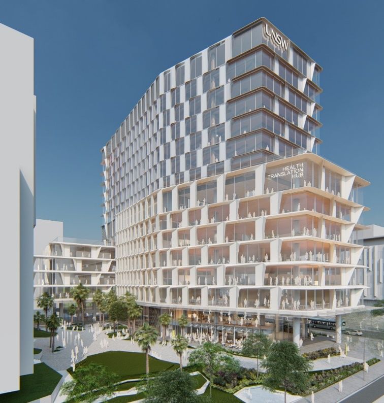
Figure 16: View from within the subject site, looking east. (Source: Image supplied by UNSW) ................... 16

Figure 17: Extract from the Heritage Map 01 on the Randwick LEP 2012. The approximate location of the
subject site is outlined in blue. (Source: Randwick LEP 2012).............................................................................. 17

Figure 18: Corana and Hygeia. (Source: NSW Heritage Database, Image taken by Stewart Watters of the
NSW Heritage Branch) .................................................................................................................................................. 18

Figure 19: Sandgate. (Source: NSW Heritage Database, Image taken by Stewart Watters of the NSW
Heritage Branch) ............................................................................................................................................................ 18

Figure 20: The Ritz Theatre. (Source: NSW Heritage Database, Image taken by Stewart Watters of the
NSW Heritage Branch) .................................................................................................................................................. 19

Figure 21: Big Stable Newmarket. (Source: NSW Heritage Database, Image taken by Stewart Watters of
the NSW Heritage Branch) ...........................................................................................................................................20

Figure 22: Nugal Hall. (Source: NSW Heritage Database, Image taken by Stewart Watters of the NSW
Heritage Branch) ............................................................................................................................................................20

Figure 23: Proposed Site Plan, with the subject site outlined in green. (Source: Architectus with NBRS
overlay)............................................................................................................................................................................. 23

Figure 24: Proposed Ground Floor Plan. (Source: Architectus) ............................................................................ 23

Figure 25: North Facade (Source: Architectus) ........................................................................................................ 24

Figure 26: East Facade (Source: Architectus) .......................................................................................................... 24

Figure 27: South Facade (Source: Architectus)........................................................................................................ 25

Figure 28: West Façade (Source: Architectus) ......................................................................................................... 25

Figure 29: Diagram showing heritage items in the vicinity of the subject site. The approximate location of
the subject site is indicated by the red outline, and the State-listed heritage items in the vicinity are
outlined and shaded in blue. (Source: NSW Planning Portal, ePlanning Spatial Viewer with NBRS overlay)
........................................................................................................................................................................................... 28

Figure 30: Proposed High Street Elevation. The proposed new building to the subject site is highlighted in
yellow. (Source: Architectus + ASPECT Studios) ..................................................................................................... 29

Figure 31: Envelope study showing the proposed building envelope within its immediate context along
Botany Street and Hight Street. (Source: Architectus + ASPECT Studios) ......................................................... 29

Figure 32: Artist’s impression of the proposal. (Source: Architectus + ASPECT Studios) ...............................30

Heritage Impact Statement – Health Translation Hub, UNSW
https://nbrsarchitecture.sharepoint.com/PROJECTS/21/21011/05_DOC/02_Reports/05_Heritage/UNSW_Health Translation Hub_HIS.docx                                                                v

HERITAGE IMPACT STATEMENT FOR
UNSW HEALTH TRANSLATION HUB – RANDWICK CAMPUS
REDEVELOPMENT

1.0         INTRODUCTION
            This report supports a State Significant Development Application (SSDA) for the proposed
            UNSW Health Translation Hub (UNSW HTH) at the Randwick Hospitals Campus (RHC),
            which is submitted to the Department of Planning, Industry and Environment (DPIE)
            pursuant to Part 4 of the Environmental Planning and Assessment Act 1979 (the Act). Health
            Infrastructure on behalf of Health Administration Corporation (HAC) is the applicant for the
            UNSW HTH, which will be delivered with the University of New South Wales (UNSW).

            The UNSW HTH forms an extension of the existing and proposed hospital facilities at the
            RHC, providing a specialist health-related research and education facility on the campus.

1.1         BACKGROUND
            A partnership agreement has been established between HAC and the UNSW to develop the
            UNSW HTH. This partnership will also allow UNSW to operate the building as well as manage
            its design and delivery.

            The partnership will bring together educational and medical researchers, clinicians,
            educators and public health officials to drive excellence, and support the rapid translation of
            research, innovation and education into improved patient care. It will strengthen the
            symbiotic relationship between UNSW and the RHC and its research institutes and broader
            health partners which form part of the Randwick Health and Innovation Precinct (RHIP).

            The UNSW HTH will build on existing affiliation between UNSW and the Sydney Children’s
            Hospital Network (SCHN); Health Infrastructure; and the South Eastern Sydney Local Health
            District, including Prince of Wales Hospital, The Royal Hospital for Women and Eastern
            Suburbs Mental Health Services.

            The subject site is not listed as an item of heritage significance on the State Heritage
            Register or Schedule 5 of the Randwick Local Environmental Plan (LEP) 2012; however it is in
            the vicinity of the following State Heritage Register items:
            -   ‘Corana and Hygeia,’ 211-215 Avoca Street, Randwick - SHR 00454;
            -   ‘Sandgate,’ 128 Belmore Road, Randwick - SHR 00067;
            -   ‘Ritz Theatre,’ 43 St Pauls Street, Randwick - SHR 00348;
            -   ‘Big Stable Newmarket,’ 29-39 Young Street, Randwick - SHR 00388; and
            -   ‘Nugal Hall,’ 16-18 Milford Street, Randwick - SHR 00173.

            Department of Planning, Industry and Environment has issued Secretary’s Environmental
            Assessment Requirements (SEARs) for the proposed development. This report has been
            prepared having regard to the relevant SEARs as follows:

                 Heritage
                 Provide a statement of significance and an assessment of the impact on the heritage
                 significance of the heritage items adjacent to the site in accordance with the guidelines in the

Heritage Impact Statement – Health Translation Hub, UNSW
https://nbrsarchitecture.sharepoint.com/PROJECTS/21/21011/05_DOC/02_Reports/05_Heritage/UNSW_Health Translation Hub_HIS.docx   PAGE 1 OF 31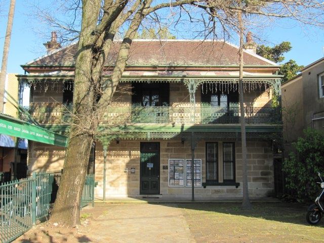
NSW Heritage Manual (Heritage Office and DUAP, 1996) and Assessing Heritage Significance
                 (OEH, 2015).

            Accordingly, this Heritage Impact Statement (HIS) reviews the proposal in terms of the
            relevant heritage provisions of the Randwick LEP 2012 and the Impact Assessment Criteria
            guidelines endorsed by the NSW Heritage Council.

1.2         METHODOLOGY
            This Heritage Impact Statement has been prepared in accordance with the guidelines set
            out in the Australia ICOMOS Charter for Places of Cultural Significance, 2013, known as The
            Burra Charter, and the New South Wales Heritage Office (now the Heritage Division of the
            NSW Office of Environment and Heritage) publication, NSW Heritage Manual.

            The Burra Charter provides definitions for terms used in heritage conservation and proposes
            conservation processes and principles for the conservation of an item. The terminology
            used, particularly the words place, cultural significance, fabric, and conservation, is as defined
            in Article 1 of The Burra Charter. The NSW Heritage Manual explains and promotes the
            standardisation of heritage investigation, assessment and management practices in NSW.

1.3         SITE DESCRIPTION AND LOCATION
            The site is located approximately 6 kilometres (km) from the Sydney Central Business
            District (CBD), within the Randwick Local Government Area (LGA). It is located approximately
            4km from Sydney Airport. Figure 1 provides a regional context map of the site showing its
            location in relation to the Sydney CBD and surrounding centres.

            This block sits in between the existing Randwick Hospitals Campus and the UNSW
            Kensington Campus, and directly adjacent to the CBD and South east Light Rail services
            which runs along High Street (Figure 2). The site of the proposed UNSW HTH has an area of
            8,897square metres (sqm).

            The site has been subject to some site preparation and early works associated with the
            broader development of the block. Adjacent to the site, along the High Street and Botany
            Road frontages, runs a 6-metre (m) wide stormwater and sewage easement.

            Although there are plans to amalgamate the lots on the site, for the purposes of this report,
            the existing lot numbers are referenced, which reflect the former, individual residential
            allotments associated with the former use of the site. The subject site comprises the
            following lots identified by the NSW Land Registry Services (LRS) as:
            -    Lots 3-14, DP12909;
            -    Lots 1-7 DP13997;
            -    Lot 1, DP300666;
            -    Lots A & B, DP 439756;
            -    Lots A-D, DP440501;
            -    Lot X and Y, DP445567;
            -    Lots 1 and 2, DP590480; and
            -    Lot 32, DP667518

Heritage Impact Statement – Health Translation Hub, UNSW
https://nbrsarchitecture.sharepoint.com/PROJECTS/21/21011/05_DOC/02_Reports/05_Heritage/UNSW_Health Translation Hub_HIS.docx   PAGE 2 OF 31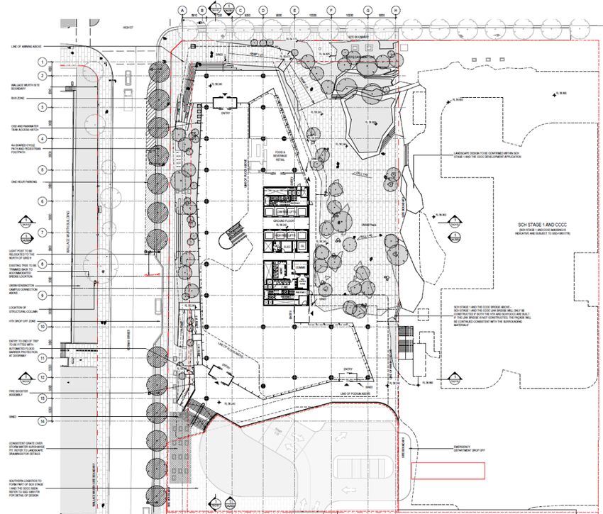
Figure 1: Site Context. (Source: Google Maps and Ethos Urban).

            Figure 2: Site aerial (Source: Nearmaps and Ethos Urban).

1.4         HERITAGE MANAGEMENT FRAMEWORK
            The subject site is not listed as an item of heritage significance on the State Heritage
            Register or Schedule 5 of the Randwick Local Environmental Plan (LEP) 2012; however it is in
            the vicinity of the following State Heritage Register items:
            -   ‘Corana and Hygeia,’ 211-215 Avoca Street, Randwick - SHR 00454;
            -   ‘Sandgate,’ 128 Belmore Road, Randwick - SHR 00067;
            -   ‘Ritz Theatre,’ 43 St Pauls Street, Randwick - SHR 00348;
            -   ‘Big Stable Newmarket,’ 29-39 Young Street, Randwick - SHR 00388; and
            -   ‘Nugal Hall,’ 16-18 Milford Street, Randwick - SHR 00173.

Heritage Impact Statement – Health Translation Hub, UNSW
https://nbrsarchitecture.sharepoint.com/PROJECTS/21/21011/05_DOC/02_Reports/05_Heritage/UNSW_Health Translation Hub_HIS.docx   PAGE 3 OF 31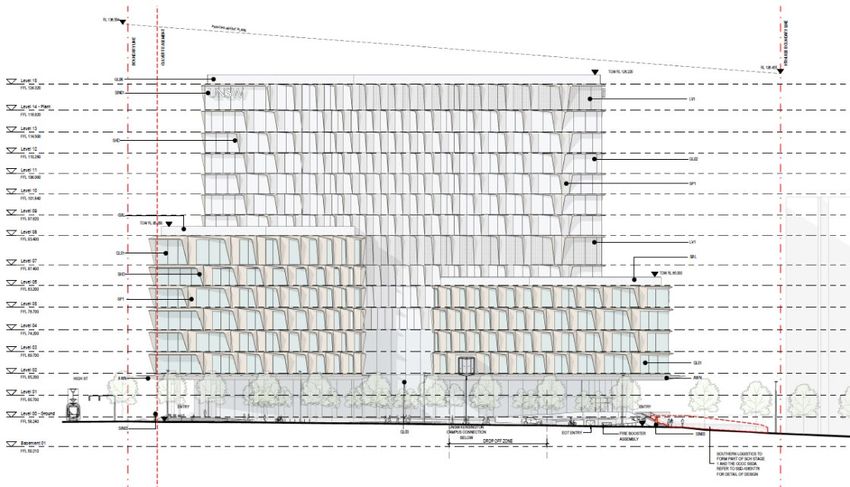
1.5         AUTHORSHIP
            This report was prepared by Christiane Moodie, Heritage Consultant, using research and a
            history written by Dr Martina Muller, Historian, of NBRSARCHITECTURE. This report has
            been reviewed by Samantha Polkinghorne, Director, of NBRSARCHITECTURE.

1.6         LIMITATIONS
            This report is limited to the assessment of potential impacts on the European cultural
            heritage values of the site and does not include Aboriginal and Archaeological assessment.
            This report only addresses the relevant planning provisions that relate to heritage.

            This report does not include an assessment of the cultural significance of the heritage items
            identified in the vicinity of the subject site. This report is limited to assessment of the impact
            of the proposed development on the significance of the heritage items identified in the
            vicinity of the subject site.

1.7         COPYRIGHT
            Copyright of this report remains with the author, NBRSARCHITECTURE. Unless otherwise
            noted, all images are by the author.

Heritage Impact Statement – Health Translation Hub, UNSW
https://nbrsarchitecture.sharepoint.com/PROJECTS/21/21011/05_DOC/02_Reports/05_Heritage/UNSW_Health Translation Hub_HIS.docx   PAGE 4 OF 31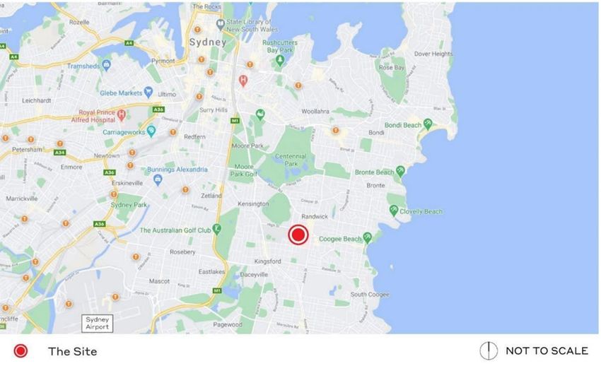
2.0         DOCUMENTARY EVIDENCE
2.1         PRE-EUROPEAN HISTORY
            Aboriginal people of the Cadigal (Gadigal) band have lived in the Randwick area for
            thousands of years. 1 Prior to European colonisation, they moved around the area, using the
            abundant natural resources of the land, the waterways and the ocean. 2 In 1995, one of the
            oldest Aboriginal campsites was discovered off Avoca Street, dating from 8,000 years before
            the present. 3

            The area of Randwick originally contained swampy areas as well as sand dunes, low scrubs
            and dense forests. 4 A stream (later named Lachlan Stream) flowed through modern
            Kensington and Eastlakes towards Botany Bay, providing a constant fresh water supply. A
            large swamp just northwest of present-day Randwick was later named Lachlan Swamps and
            subsequently became Centennial Park, in 1888. 5

2.2         DEVELOPMENT OF THE SUBURB
            The Randwick area developed very slowly and only a small number of Europeans settled in
            this swampy area in the first half of the 19th century. 6 The district became initially known for
            the Asylum for the Relief of Destitute Children (opened 1858 and later reused as the Prince
            of Wales Hospital) and the Randwick racecourse (from the 1840s, initially known as ‘sandy
            track’, later the location of the University of NSW).

            The establishment of the village of Randwick itself, from the 1850s, was largely due to
            Simeon Henry Pearce who named his property ‘Randwick’, in honour of his Gloucestershire
            village. Among the earliest buildings were St Jude’s Church of England and associated
            schoolhouse (1858), as well as the Coach and Horses Hotel (1859), which also provided
            Randwick’s first mail service.

            Figure 3: The Coach and Horses Hotel, corner Avoca and Albion Streets, Randwick, 1870-1875. (Source: State Library of NSW, Call
            No. ON 4 Box 56 No 24, Digital Order No a2824983)

1 Lawrence, J., Pictorial History. Randwick, Alexandria: Kingsclear Books, 2001, p4
2 Randwick Council, ‘Indigenous History’, http://www.randwick.nsw.gov.au/about-council/history/our-story/indigenous-history
(accessed February 2021)
3 Curby, P., Randwick, Dictionary of Sydney, 2015, https://dictionaryofsydney.org/entry/randwick (accessed February 2021)

4 Lawrence, J., Pictorial History. Randwick, Alexandria: Kingsclear Books, 2001, pp2-3

5 Curby, P., Randwick, Dictionary of Sydney, 2015, https://dictionaryofsydney.org/entry/randwick (accessed February 2021); NSW

Heritage Inventory Database, ‘Centennial Park, Moore Park, Queens Park’, Database No. 5045397
6 For this and the following see Curby, P., Randwick, Dictionary of Sydney, 2015, https://dictionaryofsydney.org/entry/randwick

(accessed February 2021)

Heritage Impact Statement – Health Translation Hub, UNSW
https://nbrsarchitecture.sharepoint.com/PROJECTS/21/21011/05_DOC/02_Reports/05_Heritage/UNSW_Health Translation Hub_HIS.docx   PAGE 5 OF 31
Randwick developed into a densely populated suburb during the second half of the 19th
century. Various grand houses, such as Sandgate or Ventnor, were built during the 1870s, and
Randwick Town Hall opened in 1882. Randwick Post Office opened in 1897. An extensive
tramway network, built between 1880 and 1921, making travelling to the city easier.
The population increased sharply again during the interwar years, which led to the
construction of numerous flat buildings. High-rise buildings proliferated during the 1960s,
and the suburb increasingly started to lose its original English village character, with many
historic buildings being demolished to make way for large scale developments. This trend
has continued over the last 30 years and many low-rise interwar streetscapes have been
replaced by large centres with multi-storey buildings.
Figure 4: Randwick Post Office, c1910. (Source: NSW State Archives & Records, File 4346_a020_a020000005)
2.3 BRIEF HISTORY OF THE SUBJECT SITE
The subject site is sited on a block of land located between the Prince of Wales Hospital in
the east and the University of NSW Campus in the west. It was originally part of a parcel of
land containing six acres, two roods and 25 perches, granted to Simeon Henry Pearce and
James Pearce by Crown Grant dated 1 November 1851. 7
By August 1889, that same parcel of land (bar three perches) was owned by Edwin Thomas
Penfold and George Wall, who brought it under Torrens Title. 8 The Certificate of Title noted
a lease made on 1 June 1886 to Charles Morton Pearce, nurseryman, of part of the site for
a period of six years and six months. Charles M. Pearce and his brother, Alfred Pearce were
both noted as nurserymen and florists on the south side of High Street in the Sydney Sands
Directory of 1889, with Mrs. Sophia Pierce listed at the adjacent “The Willows”. 9
7 NSW LRS, CT Vol. 936 fol. 137.
8 Ibid.
9 City of Sydney Archives, Sydney Sands Directory, 1889, Randwick – High Street South.
Heritage Impact Statement – Health Translation Hub, UNSW
https://nbrsarchitecture.sharepoint.com/PROJECTS/21/21011/05_DOC/02_Reports/05_Heritage/UNSW_Health Translation Hub_HIS.docx PAGE 6 OF 31Figure 5: Detail from 1859 map showing the location of the subject site at the corner of High and Botany Streets
(circled red), adjacent to the Asylum for Destitute Children. (Source: State Library of NSW, ‘Randwick Waverley &
Coogee 1859’, c00704)
Messrs. Pierce Brothers established a flower and plant nursery at the site, “situated at
Randwick, not far from the back of the Randwick Asylum, and here, in a warm sheltered
undulation, protected by numbers of old large pines, willows, and other trees, they cultivate
an area of about 12 acres, and produce not only plants for sale, but enormous quantities of
beautiful flowers to supply its large and increasing demand in Sydney.”10 The brothers had
bought the business of Treseder and Bartlett at the Sydney Arcade and sent “every morning
and average of from eight to ten large clothes baskets full of cut flowers” 11 from Randwick,
where they grew an enormously wide range of plants such as violets, roses, petunias, ferns,
orchids. The site contained various bush houses, glasshouses, hothouses, frames, and
potting sheds, and a small watercourse as well as various wells and ponds ensured a
sufficient supply of water. 12 By 1893, Pearce Brothers were known as ‘Vice-Regal Florists’,
with nurseries at Randwick and Gosford. 13
Charles M. Pearce acquired the site on 19 February 1903 and leased part of it to William
George Valentine, also a nurseryman and florist, from May that same year. 14 It appears that
Pearce Bros. remained at Randwick, as in 1905 they reportedly had 30 acres of nursery
grounds at Randwick and Botany. 15 However, in 1911 they sold the Randwick property to
Albert Edward Reid, a commercial traveller from Sydney, who subdivided it three years later,
10 ‘AMONG THE FLOWER NURSERIES.’, Sydney Morning Herald (NSW : 1842 - 1954), 14 September 1889, 15, http://nla.gov.au/nla.news-
article13744632.
11 ‘AMONG THE FLOWER NURSERIES.’, 15.
12 ‘HORTICULTURAL.’, Sydney Mail and New South Wales Advertiser (NSW : 1871 - 1912), 25 May 1889, 1070, http://nla.gov.au/nla.news-
article161933322.
13 ‘City of Sydney Archives’, accessed 2 February 2021, https://archives.cityofsydney.nsw.gov.au/nodes/view/1562747.
14 NSW LRS, CT Vol. 1468 fol. 16.
15 ‘PEARCE BROS.’, Sydney Morning Herald (NSW : 1842 - 1954), 21 December 1905, 3, http://nla.gov.au/nla.news-article14721103.
Heritage Impact Statement – Health Translation Hub, UNSW
https://nbrsarchitecture.sharepoint.com/PROJECTS/21/21011/05_DOC/02_Reports/05_Heritage/UNSW_Health Translation Hub_HIS.docx PAGE 7 OF 31selling the allotments on the western side of the newly formed Eurimbla Avenue to Frederick
Curry and the rest to Charles William Coulton (Figure 6). Both transfers were noted on 21
September 1914, with the subdivision registered as Deposited Plan 7745. 16
Figure 6: 1914 – Deposited Plan 7745, dated 8 July 1914,
showing lots transferred to Frederick Curry shaded grey. The
approximate extent of the subject site is outlined in red. The
allotments to the south, facing Magill Street, were not part of
that subdivision. (Source: NSW LRS, DP7745)
After Charles W. Coulton’s death, his property was transferred to his wife Alice Maud Coulton,
Charles F. Coulton and William L. Coulton, and a new Certificate of Title was issued in May
1920, initiating the subsequent sale of allotments to individual buyers who developed them
for residential purposes. 17 While the Sydney Sands Directory listed 5 occupants on the eastern
side of Botany Street, between High and Magill Streets in 1920, there were 26 individual
occupants at 49 to 101 Botany Street, Randwick, in 1930. 18
Frederick Curry on the other hand began to sell his allotments from 1916, two years after he
had acquired the land on the western side of Eurimbla Avenue. Most of these allotments
were transferred to Sydney Coulton, a builder from Waverley, in successive and separate
transactions. 19 Only our allotments (18 and 19, 20 and 29) were sold to other individuals
between 1916 and 1921.
On 9 October 1918, the Commonwealth acquired six allotments on the western side of
Eurimbla Avenue (Lots 26-31) and two allotments on the eastern side (Lots 35-36) for
defence purposes. 20 The property contained a row of 10 or 14 pairs of existing cottages,
likely built by Sydney Coulton during his brief ownership. These cottages were acquired for
use as homes for nurses at the nearby hospital, which had become a Military Repatriation
16 NSW LRS, CT Vol. 1468 fol. 16.
17 NSW LRS, CT Vol. 2521 fol. 228.
18 City of Sydney Archives, Sydney Sands Directory, 1920 and 1930, Randwick – Botany Street East.
19 NSW LRS, CT Vol. 2521 fol. 227.
20 ‘NOTIFICATION OF THE ACQUISITION OF LAND BY THE COMMONWEALTH.’, Commonwealth of Australia Gazette (National : 1901 -
1973), 17 October 1918, 2038, http://nla.gov.au/nla.news-article232462662.
Heritage Impact Statement – Health Translation Hub, UNSW
https://nbrsarchitecture.sharepoint.com/PROJECTS/21/21011/05_DOC/02_Reports/05_Heritage/UNSW_Health Translation Hub_HIS.docx PAGE 8 OF 31Hospital. 21 After the war, the cottages were occupied by ex-servicemen, with the Defence
Department in March 1921 planning to sell the allotments. 22 On 27 July 1922, Lots 26 to 31
and 36 were sold to the War Service Homes Commissioner, who subdivided the land as
registered in DP 12909 and sold the newly created allotments to individual buyers from early
1925. 23 Accordingly, the Sydney Sands Directory noted 12 occupants on the western side of
Eurimbla Avenue in 1920, but by 1930 there were 33 occupants listed from 2 to 68 Eurimbla
Avenue. 24
An aerial photograph dated 1943 shows the area of the former Pearce Bros. Nursery fully
developed with residential buildings (Figure 7). By that time, the area immediately to the east
was in use as the Randwick Military Hospital, renamed the Prince of Wales Hospital in 1953,
while the area to the west of Botany Street was still known as Randwick Park, and it was not
until 1959 that it became part of the University of NSW campus.
Further subsequent subdivision and amalgamation of allotments at the subject property
appears to have occurred until recently, when the subject site was acquired by the NSW
State Government as part of a larger land acquisition and planned expansion of the Prince
of Wales Hospital. On 4 September 2018, the Sydney Eastern City Planning Panel and
Randwick City Council granted development consent for demolition of 92 dwellings and
ancillary structures, including the buildings at the subject site (DA/208/2018). 25 Demolition
of all existing buildings on the site was subsequently carried out.
Figure 7: 1943 – Aerial photograph with the approximate extent of the subject site outlined in red. (Source:
NSW LRS, SIX Maps, 1943 aerial imagery)
21 ‘FEDERAL COTTAGE DEAL’, Sunday Times (Sydney, NSW : 1895 - 1930), 27 October 1918, 5, http://nla.gov.au/nla.news-
article123138536; ‘TWO INTERROGATORIES’, World (Hobart, Tas. : 1918 - 1924), 16 March 1921, 4, http://nla.gov.au/nla.news-
article187562202.
22 ‘DIGGERS, GET OUT’, Smith’s Weekly (Sydney, NSW : 1919 - 1950), 5 March 1921, 1, http://nla.gov.au/nla.news-article234267953.
23 NSW LRS, CT Vol. 2940 fol. 163; Vol. 3358 fol. 225.
24 City of Sydney Archives, Sydney Sands Directory, 1920 and 1930, Randwick – Eurimbla Avenue West.
25 NSW Government, Prince of Wales Hospital Expansion Stage 1. SSD 9113, February 2019, 2. 7.
Heritage Impact Statement – Health Translation Hub, UNSW
https://nbrsarchitecture.sharepoint.com/PROJECTS/21/21011/05_DOC/02_Reports/05_Heritage/UNSW_Health Translation Hub_HIS.docx PAGE 9 OF 312.4 SUMMARY HISTORY OF THE PRINCE OF WALES HOSPITAL
The Prince of Wales Hospital opened as the Asylum for Destitute Children in 1858, in a
building designed by NSW Colonial Architect, Edmund Blacket. 26 The asylum was located on
a grant of 60 acres, made in 1854 to Randwick’s first Mayor, Simeon Henry Pearce, and was
constructed due to the efforts of the Society for Destitute Children, formed in 1852.
The asylum gradually increased in size, with a wing added in 1868 and the Catherine Hayes
Hospital opening in 1870. During World War I, the site was converted and used as a military
hospital, known as the Randwick Military Hospital. 4,000 soldiers camped in the asylum’s
paddock in October 1914, prior to embarkation to the Middle East. 27 From 1916, the armed
forces officially managed the hospital and continued to do so during World War II, until 1953,
when the last soldiers were transferred to the new Concord Repatriation Hospital.
In 1953, the hospital was renamed The Prince of Wales Hospital and run as an annex to the
Sydney Hospital. In 1961, it was restructured and managed in association with the Prince
Henry Hospital at Little Bay, and two years later the two hospitals were amalgamated under
one board.
Figure 8: 1955 – Prince of
Wales Hospital, Randwick,
photographed by Max
Dupain. (Source: State
Library of NSW, ‘File 016:
Prince of Wales Hospital,
Randwick, December 1955’,
ON 559/Box 19/no. 384)
During the 1990s, a major campus upgrade was undertaken, and the Royal Hospital for
Women at Paddington and various wards from the Prince Henry Hospital relocated to
Randwick. The Prince of Wales Children’s Hospital, established in 1976, was also
redeveloped and renamed the Sydney Children’s Hospital during the 1990s. 28 When Prince
Henry Hospital closed in 2001, its services were transferred to Randwick.
In 2017 the $114 million Bright Building was opened, housing the Prince of Wales Hospital’s
‘Nelune Comprehensive Cancer Centre’, UNSW’s ‘Scientia Clinical Research’ project and an
expansion of the Sydney Children’s Hospital Network. The campus is currently part of a
major redevelopment scheme undertaken by the NSW Government.
26 If not otherwise noted, this and the following has been summarised from Prince of Wales Hospital, Our History,
https://www.seslhd.health.nsw.gov.au/prince-of-wales-hospital/about-us/our-history (accessed February 2021)
27 ‘Randwick Military Hospital Heritage Tour’, National Trust (blog), accessed 2 February 2021,
http://staging.nationaltrust.org.au/ahf_event/randwick-military-hospital-heritage-tour/.
28 The Sydney Children’s Hospitals Network, About Sydney Children’s Hospital, Randwick,
https://www.schn.health.nsw.gov.au/about/about-sydney-childrens-hospital-randwick (accessed February 2021)
Heritage Impact Statement – Health Translation Hub, UNSW
https://nbrsarchitecture.sharepoint.com/PROJECTS/21/21011/05_DOC/02_Reports/05_Heritage/UNSW_Health Translation Hub_HIS.docx PAGE 10 OF 312.5 SUMMARY HISTORY OF THE UNIVERSITY OF NEW SOUTH WALES, KENSINGTON CAMPUS
The University of New South Wales began as The New South Wales University of Technology
in 1949, established by the NSW Government as a technological university. 29 The new
university initially operated from the Sydney Technical College in Ultimo, itself founded in
1878, but from the early 1950s most of the university’s administrative functions relocated
from Ultimo to the new Kensington campus, where an extensive building program was
underway.
The Kensington campus area was originally Crown land and consisted of three separate
main areas: the former Tramway Depot, the Kensington Racecourse and Randwick Park,
which were acquired by the University in separate stages during the 1950s.
The largest portion of the site, today containing the lower and central campus areas, was
originally the Kensington Racecourse which was from 1893 leased to G. R. Rowley, the
Secretary of the Kensington Recreation Grounds Company. 30 Rowley established a
racecourse for ponies and a galloways (small horses) and built associated saddling
paddocks, jockey rooms, two grandstands and a totalisator building on this site. Some of
these structures are today still located on campus, such as the totalisator building (now
known as the Old Tote Building) and the jockey’s changerooms and weighing Area (now the
White House). The racecourse was at various times used as a military camp, and in 1948 a
migrant hostel operated at the site. The recreation hall (now the Fig Tree Theatre) of the
Migrant Hostel also still exists, as well as several Moreton Bay fig trees from the 19th Century.
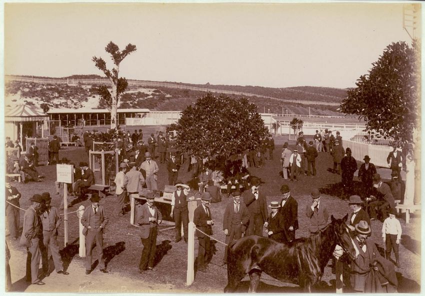
Figure 9: Kensington Racecourse, c1900-1910, showing the betting rings, with the racecourses and saddling paddocks visible in the
background. (Source: State Library of NSW, Call No. PXE 711/295, IE No. 1669207, Digital ID a116295h)
29 The following information is based on the following: McLintock, R., The Development of the Buildings and Grounds of the University of
New South Wales, March 1993; UNSW Website, About Us – The University – History, https://www.unsw.edu.au/about-
us/university/history (accessed February 2021); UNSW Records & Archives, Online Exhibitions,
https://www.recordkeeping.unsw.edu.au/historicalresources/online_exhibitions.html (accessed February 2021).
30 McMahon, J., Kensington – A Model Suburb, Randwick: Randwick and District Historical Society, 1986, p30
Heritage Impact Statement – Health Translation Hub, UNSW
https://nbrsarchitecture.sharepoint.com/PROJECTS/21/21011/05_DOC/02_Reports/05_Heritage/UNSW_Health Translation Hub_HIS.docx PAGE 11 OF 31A smaller portion of the university campus is located at the top of a sand-hill, near the corner
of Botany and High Streets. This was originally occupied by Randwick Park, dedicated in
1884 and rededicated in 1903, extending east to Botany Street and south to Barker Street. 31
The park was said to have been leased for quarrying to a man named Green until rededication
in 1903. 32 Although the park was dedicated for the purpose of public recreation, the Council
continued quarrying for its own purpose, filling and levelling the slope down towards the
racecourse with garbage.
By around the second half of the 1910s this levelling and tipping had created an oval which
became known as the Randwick Oval. Quarrying appears to have continued into the early
1920s, with further garbage tipping and levelling. A Municipal Golf Course was opened in
December 1932, 33 in the north-eastern corner of the site, extending west towards the oval. A
children’s playground was said to have been located to the southeast of the golf course.
Randwick Park was transferred as a whole from Randwick Council to the University on 20
November 1959, to become what is known today as the upper campus.
The third area, located west of Anzac Parade, was a tramway depot and part of a Migrant
Hostel prior to acquisition of the site by the University. Prior to bus services being
established, trams used to bring patrons of Kensington Racecourse to High Street, “and then
shunt into an enclosed paddock used exclusively by the department.” 34 The trams, running on
the Randwick and Coogee Line, 35 were said to have effectively parked at the depot until the
race meetings concluded, and there were repeated calls to sell this valuable piece of land to
bring it to better use. Becoming redundant during the 1940s, the 3.5-acre site (1.4ha) was
initially reserved for the proposed elevated Eastern Suburbs Railway. 36 The northern portion
later became part of a Transport Department Migrant Hostel. 37
After acquisition by the university, the first building constructed as part of the new
Kensington campus was the Main Building which was completed in 1955. Other buildings
from the initial phases of campus development include the Basser College (1959, now
demolished), University Union/Roundhouse (1961), Heffron Building (1962), Goldstein
College (1963, now demolished), Wallace Wurth & Biological Sciences buildings (1963), the
Blockhouse (1965), and Chancellery (1966), to name but a few.
31 Randwick Public Park, New South Wales Government Gazette, 6 June 1884, Issue No 261, p3630; Randwick Park, Daily Telegraph, 12
February 1903, p8
32 If not otherwise noted, the following is based on a Letter from John Metcalfe (University Librarian) to G. Macauley (Registrar), dated 4
March 1965, UNSW Archives, SRF – Kensington Campus, Site Pre-1950 file
33 Opening of Randwick Course, Sydney Morning Herald, 7 December 1932, p16
34 Kensington – Sydney’s Oldest ‘Pony’ Course, Referee, 24 August 1939, p2
35 Ibid.; cf. NSW Government Railways and Tramways, Tramway Guide to Sydney and Suburbs, Sydney: W.E. Smith, 1900, pp16-17
36 Freestone and Pullan, Adaptive Master Planning, 2018, p145
37 Baxter, P., Eight Years of Change, Tharunka, 20 December 1966, p4
Heritage Impact Statement – Health Translation Hub, UNSW
https://nbrsarchitecture.sharepoint.com/PROJECTS/21/21011/05_DOC/02_Reports/05_Heritage/UNSW_Health Translation Hub_HIS.docx PAGE 12 OF 31Figure 10: 1964 – The main
walkway at UNSW as seen
from Anzac Parade. (Source:
UNSW Records & Archives,
UNSW: A Portrait. Looking
back over 60 years,
https://www.recordkeeping.u
nsw.edu.au/documents/60an
niversary_slide_14Sept.pdf
(accessed February 2021)
Today, the Kensington campus is a 38-hectare site which contains various buildings and
spaces added over a period of over 65 years. The campus reflects the continuous growth of
the university as well as the various development strategies implemented over the years,
ranging from the first building program (from 1950) to the first overall master plan (1976),
its 1984 update, the 1990s campus redevelopment, and the Campus 2020 Master Plan. 38
Recent notable buildings and projects include the Roundhouse Refurbishment Project
(2018), the Clancy Auditorium Upgrade (2019), completion of the Biological Sciences
Buildings (2018 and 2019), Electrical Engineering Building Refurbishment (2019) and the
Science and Engineering Building (2019). 39
38 UNSW Records & Archives, Campus Development Exhibition,
www.recordkeeping.unsw.edu.au/historicalresources/onlineexhibitions/kensington.html (accessed February 2021)
39 UNSW Sydney, Estate Management – Campus Development, www.estate.unsw.edu.au/campus-development (accessed February
2021)
Heritage Impact Statement – Health Translation Hub, UNSW
https://nbrsarchitecture.sharepoint.com/PROJECTS/21/21011/05_DOC/02_Reports/05_Heritage/UNSW_Health Translation Hub_HIS.docx PAGE 13 OF 313.0 PHYSICAL EVIDENCE
3.1 SITE CONTEXT AND DESCRIPTION
The subject site is located on the southern side of High Street, Randwick, to the east of the
existing UNSW Kensington Campus and to the west of the existing Randwick Hospitals
Campus. The built form of the surrounding area is characterised by a mix of residential
blocks, generally comprising single dwellings and two and three storey apartment buildings,
and the larger institutional buildings of the University of New South Wales and the Randwick
Hospitals Campus. High Street connects the university and the hospital, running on a roughly
east-west axis from Anzac Parade to the Randwick shops on Avoca Street and Belmore
Road.
The site used to be occupied by a number of residential dwellings, which have been recently
demolished, and now stands vacant.
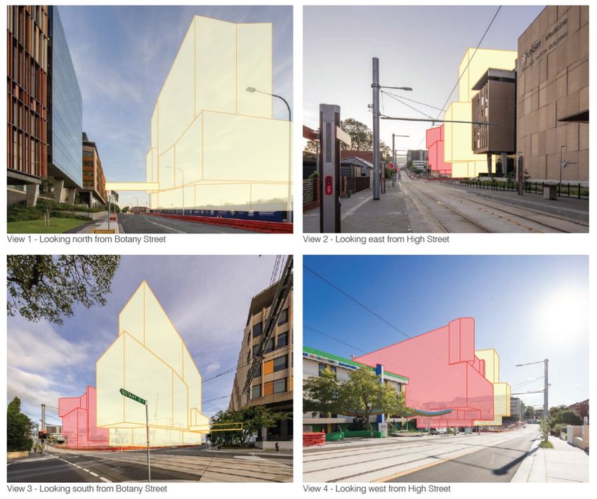
3.2 VIEWS
Primary views of the subject site are those available close to the northwest corner, looking
south from High Street and looking east from Botany Street.
More distant views of the site are largely obtained of the western portion of the site from the
UNSW Kensington Campus, particularly from buildings opening onto Botany Street, as well
as of the eastern portion of the site from the Sydney Children’s Hospital.
Views of the front (northern) portion of the property become more obscured in each direction
along High Street, and views of the side (western) portion of the property become more
obscured in each direction along Botany Street. Currently, views are obtainable of the rear
(southern) portion of the property from Magill Street, and of the eastern portion of the
property from Hospital Road. However, future development towards the northeast,
southeast and southwest portions of the block will soon partially obscure these views.
There are currently no distant views or vistas available from, or of, the subject site. However,
there is a possibility that future mid- to high-rise development on the site may be visible from
other areas in the surrounding suburb.
Heritage Impact Statement – Health Translation Hub, UNSW
https://nbrsarchitecture.sharepoint.com/PROJECTS/21/21011/05_DOC/02_Reports/05_Heritage/UNSW_Health Translation Hub_HIS.docx PAGE 14 OF 31Figure 11: View of the
subject site looking east
along High Street. The
subject site is indicated
by the red arrow.
(Source: Architectus +
ASPECT Studios)
Figure 12: View towards
the subject site looking
west along High Street.
The subject site is
indicated by the red
arrow. (Source:
Architectus + ASPECT
Studios)
Figure 13: View of the
subject site at the
intersection of Magill
Street and Hospital
Road. The subject site is
located at the northwest
corner of this block, and
indicated by the red
arrow. (Source: Google
Streetview)
Figure 14: View looking
north along Botany
Street, close to the
intersection of Botany
Street and Magill Street.
The subject site is
located at the northwest
corner of this block and
is indicated by the red
arrow. (Source:
Architectus + ASPECT
Studios)
Heritage Impact Statement – Health Translation Hub, UNSW
https://nbrsarchitecture.sharepoint.com/PROJECTS/21/21011/05_DOC/02_Reports/05_Heritage/UNSW_Health Translation Hub_HIS.docx PAGE 15 OF 31Figure 15: View of the
northwest corner of
subject site from High
Street, indicated by the
red arrow. (Source:
Architectus + ASPECT
Studios)
Figure 16: View from
within the subject site,
looking east. (Source:
Image supplied by
UNSW)
Heritage Impact Statement – Health Translation Hub, UNSW
https://nbrsarchitecture.sharepoint.com/PROJECTS/21/21011/05_DOC/02_Reports/05_Heritage/UNSW_Health Translation Hub_HIS.docx PAGE 16 OF 314.0 ESTABLISHED HERITAGE SIGNIFICANCE
4.1 HERITAGE STATUS
The subject site is not listed as an item of heritage significance on the State Heritage
Register or Schedule 5 of the Randwick Local Environmental Plan (LEP) 2012; however it is in
the vicinity of the following State Heritage Register items:
- ‘Corana and Hygeia,’ 211-215 Avoca Street, Randwick - SHR 00454;
- ‘Sandgate,’ 128 Belmore Road, Randwick - SHR 00067;
- ‘Ritz Theatre,’ 43 St Pauls Street, Randwick - SHR 00348;
- ‘Big Stable Newmarket,’ 29-39 Young Street, Randwick - SHR 00388; and
- ‘Nugal Hall,’ 16-18 Milford Street, Randwick - SHR 00173.
Details of these items are included below.
Other heritage listed items in the vicinity of the subject site are visually and physically
separated from the site by intervening development, local topography, roadways and
distance.
Figure 17: Extract from the
Heritage Maps 002 (to the
left) and 007(to the right) on
the Randwick LEP 2012. The
approximate location of the
subject site is outlined in blue,
and the approximate location
of the identified State-listed
items in the vicinity are
outlined in green. (Source:
Randwick LEP 2012)
4.2 SIGNIFICANCE OF CORANA AND HYGEIA
The following Statement of Significance for Corana and Hygeia located at 211 – 215 Avoca
Street, Randwick, is sourced from the NSW Heritage Database, reference number 5045332:
Corana and Hygeia are of State heritage significance as two semi-detached mansions in
the late Victorian style and constructed in 1898. They have particular aesthetic
significance as a large and picturesque late Victorian two-storey pair of houses with good
cast iron work on the verandah valences and columns. It has heavily decorated
balustraded roof parapets, classically derived tiled verandah floors and front fences of
cast iron and masonry. The building is of excellent streetscape value and provides a
significant contribution to the High Cross townscape precinct at Randwick. Their
Heritage Impact Statement – Health Translation Hub, UNSW
https://nbrsarchitecture.sharepoint.com/PROJECTS/21/21011/05_DOC/02_Reports/05_Heritage/UNSW_Health Translation Hub_HIS.docx PAGE 17 OF 31historical significance is derived from its association with the family of Judge Thomas
Callaghan, a prominent citizen and member of the judiciary.
Figure 18: Corana and
Hygeia. (Source: NSW
Heritage Database,
Image taken by Stewart
Watters of the NSW
Heritage Branch)
4.3 SIGNIFICANCE OF SANDGATE
The following Statement of Significance for Sandgate located at 128 Belmore Road,
Randwick, is sourced from the NSW Heritage Database, reference number 5045450:
Sandgate constructed circa 1879 is a two storey sandstone residence. It is associated
with Simeon Pearce and the Pearce family who were prominent in the early society and
politics of Randwick Municipality. It was designed as a ‘Gentleman’s residence’ and the
house retains its original character.
Figure 19: Sandgate.
(Source: NSW Heritage
Database, Image taken by
Stewart Watters of the NSW
Heritage Branch)
Heritage Impact Statement – Health Translation Hub, UNSW
https://nbrsarchitecture.sharepoint.com/PROJECTS/21/21011/05_DOC/02_Reports/05_Heritage/UNSW_Health Translation Hub_HIS.docx PAGE 18 OF 314.4 SIGNIFICANCE OF THE RITZ THEATRE
The following Statement of Significance for the Ritz Theatre located at 43 St Pauls Street,
Randwick, is sourced from the NSW Heritage Database, reference number 5045406:
The Randwick Ritz is a good example of a picture theatre showing the smaller scaling
and reduced decoration often applied to suburban theatres. It is one of the few surviving
examples of the hundreds of cinema which were built during the 1930's, the most
creative period of cinematic design in Australia It has many fine pieces of Art Deco
decoration in a restrained Art Deco setting. The Ritz Theatre is a record of the cinema
culture of the 1930's. The building has an excellent ability to interpret aspirations, uses,
tastes and importance of cinema in the society of the 1930s It is the last known surviving
theatre by A.M. Bolot. Following demolition or alteration of most suburban picture
theatres, it is now an important and rare survival.
Figure 20: The Ritz Theatre.
(Source: NSW Heritage
Database, Image taken by
Stewart Watters of the NSW
Heritage Branch)
4.5 SIGNIFICANCE OF BIG STABLE NEWMARKET
The following Statement of Significance for the Big Stable Newmarket located at 29-39
Young Street, Randwick, is sourced from the NSW Heritage Database, reference number
5045439:
The "Big Stable' is significant on the grounds of architectural quality, unusual function
and building type of historic importance. The Newmarket Precinct (Big Stable,
Newmarket House, Sale Ring and Training Stables) will assist in the preservation of an
historic asset of unusual value to the national heritage and to the municipality of
Randwick. The graceful, homely and unpretentious structure of this site survive almost
intact from the 19th century amid well kept trees, lawns and pavements. The occupants
of the site survive continue today the horse breeding and training activities traditionally
associated with Randwick and give support to complimentary activities in the
neighbourhood, in complete harmony with the residential character of the area once
known as 'Struggle Town'. Respect for Newmarket's prestige in its associations with
Australia's thoroughbred horse breeding industry also extends beyond national borders.
Heritage Impact Statement – Health Translation Hub, UNSW
https://nbrsarchitecture.sharepoint.com/PROJECTS/21/21011/05_DOC/02_Reports/05_Heritage/UNSW_Health Translation Hub_HIS.docx PAGE 19 OF 31Figure 21: Big Stable
Newmarket. (Source: NSW
Heritage Database, Image
taken by Stewart Watters of
the NSW Heritage Branch)
4.6 SIGNIFICANCE OF NUGAL HALL
The following Statement of Significance for Nugal Hall located at 16-18 Milford Street,
Randwick, is sourced from the NSW Heritage Database, reference number 5045442:
Nugal Hall is of State significance as an example of an impressive two storey mansion
constructed of stone in the Gothic Revival style. Designed by the Colonial Architect
Mortimer Lewis it was constructed in 1853. The land was a grant to Alexander Arthur, in
1851 by Governor Fitzroy, of 200 acres. Although not of the very high quality of a few
Sydney Gothic Revival houses and despite some 1920s and '30s decorative additions
Nugal Hall is nevertheless impressive. It is associate with a number of significant people.
It is significant in Coogee/Randwick where increasing high rise development has
deprived the area of much of its architectural history. The house sits well in its grounds
and is visually important locally..
Figure 22: Nugal Hall. (Source: NSW Heritage
Database, Image taken by Stewart Watters of the
NSW Heritage Branch)
Heritage Impact Statement – Health Translation Hub, UNSW
https://nbrsarchitecture.sharepoint.com/PROJECTS/21/21011/05_DOC/02_Reports/05_Heritage/UNSW_Health Translation Hub_HIS.docx PAGE 20 OF 31You can also read