Rangitāne o Manawatu Statutory Acknowledgements
←
→
Page content transcription
If your browser does not render page correctly, please read the page content below
Rangitāne o Manawatu Statutory
Acknowledgements
This attachment to the One Plan lists:
1. The Statutory Acknowledgements in the Manawatu-Whanganui Region as identified by
Rangitāne o Manawatu;
2. The statements of association relating to the Statutory Acknowledgements are also
provided along with the maps that show these statutory areas; and
3. The relevant clauses from the Rangitāne o Manawatu Claims Settlement Act 2016.
Attachment of Statutory Acknowledgements is In accordance with section 32 of the Rangitāne o
Manawatu Claims Settlement Act 2016.
Statutory Areas
Rangitāne o Manawatu has statutory acknowledgements for the following statutory areas:
Statutory Area Location
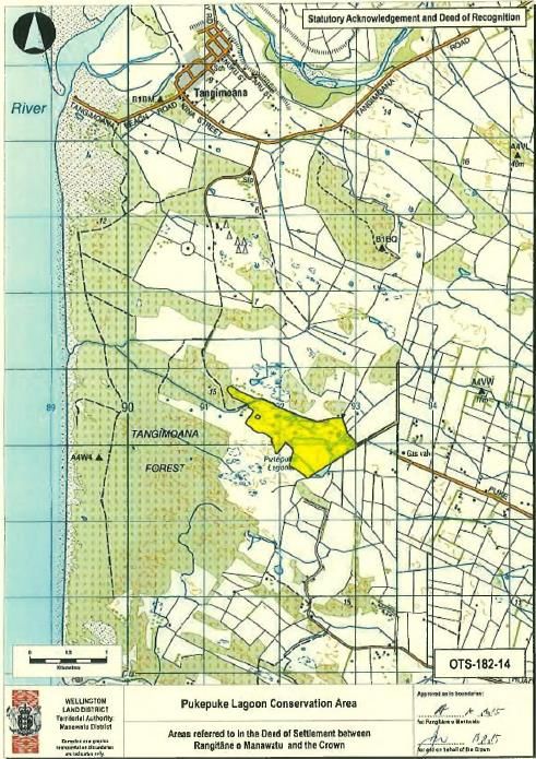
Pukepuke Lagoon As shown on OTS-182-14
Manawatu Scenic Reserve As shown on OTS-182-15
Omarupapako/ Roundbush Scenic Reserve As shown on OTS-182-16
Tawhirihoe Scientific Reserve As shown on OTS-182-17
Ruahine Forest Park As shown on OTS-182-18
Tararua Forest Park As shown on OTS-182-19
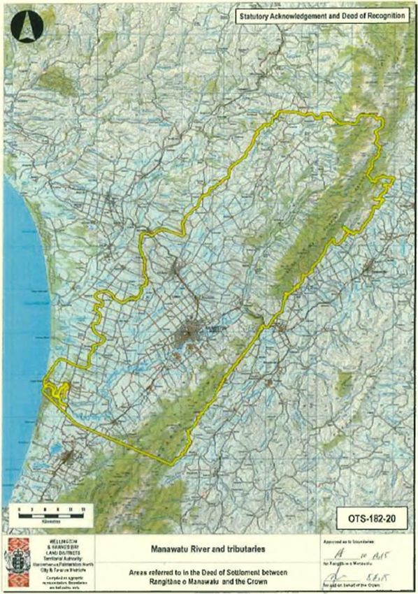
Manawatu River and Tributaries As shown on OTS-182-20
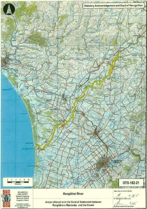
Rangitikei River As shown on OTS-182-21
Pohangina River As shown on OTS-182-22
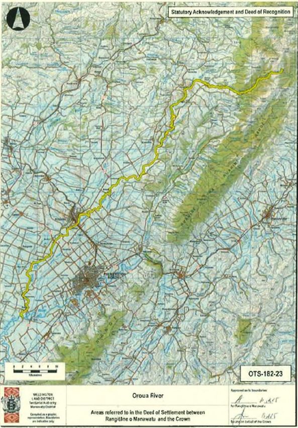
Oroua River As shown on OTS-182-23
Mangahao River As shown on OTS-182-24
Coastal Area As shown on OTS-182-25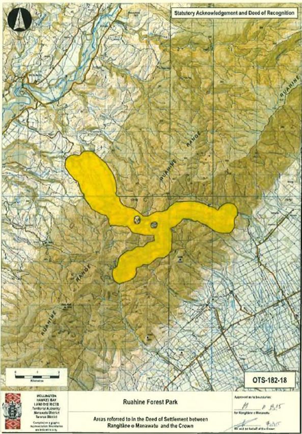
Statutory Acknowledgment for the Pukepuke Lagoon Conservation
Area
Statutory Area
The area to which this statutory acknowledgement applies is the Pukepuke Lagoon Conservation
Area, as shown by OTS-182-14.

Statement of Association
Preamble
Under section 29 of the Rangitāne o Manawatu Claims Settlement Act the statement, the Crown
acknowledges the statement of association made by Rangitāne o Manawatu of their particular
cultural, spiritual, historical, and traditional association with the Pukepuke Lagoon Conservation
Area.
Rangitāne o Manawatu cultural, spiritual, historical, and traditional association with the
Pukepuke Lagoon Conservation Area
Pukepuke Lagoon is of immense historical, cultural, spiritual and traditional significance to Rangitāne
o Manawatu.
Lakes Omanuka, Pukepuke and Kaikokopu provided valuable mahinga kai and an abundance of tuna
to Rangitāne o Manawatu in the early times. They are the places where Rangitāne o Manawatu
would stop overnight to replenish food stocks and to rest while travelling between Rangitikei and
Manawatu. Lakes Omanuka and Kaikokopu remain in Māori ownership however the title of Lake
Pukepuke is now vested in the Department of Conservation.
Pa were established on the southern side of the Pukepuke Lagoon. Mahinga kai were also
established and still utilised today.
Land Court records pertaining to the Himatangi Block reveal that the area was an important source
of eel, fern root, kokapu, koko (tui), kereru and kiekie. Numerous cultivations were situated along
the Coast, particularly Himatangi. A variety of native and migrating birds were located in the
wetlands, lagoons, lakes and swamps at Himatangi and Pukepuke.
Rangitāne o Manawatu oral histories record a number of battles occurring in the vicinity and over
the lagoon.
As Rangitāne o Manawatu develop their capacity they look forward to the future and the time when
they are fully engaged in upholding the principle of kaitiaki over Pukepuke Lagoon.
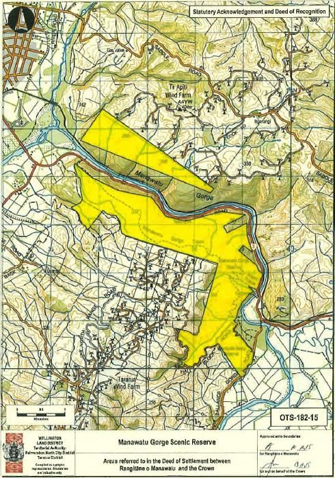
Statutory Acknowledgment for the Manawatu Gorge Scenic
Reserve
Statutory Area
The area to which this statutory acknowledgement applies is the Manawatu Gorge Scenic Reserve,
as shown by OTS-182-15.

Statement of Association
Preamble
Under section 29 of the Rangitāne o Manawatu Claims Settlement Act the statement, the Crown
acknowledges the statement of association made by Rangitāne o Manawatu of their particular
cultural, spiritual, historical, and traditional association with the Manawatu Gorge Scenic Reserve.
Rangitāne o Manawatu cultural, spiritual, historical, and traditional association with the
Manawatu Gorge Scenic Reserve
The name Te Apiti was bestowed upon the Manawatu Gorge by Rangitāne o Manawatu as it was
recognised as one of the main routes connecting the eastern and western parts of their seven
hundred year old rohe. The gorge today remains an important access route from the western side of
the Tararua and Ruahine Ranges.
In Rangitāne o Manawatu history, it was Okatia, a spirit which possessed a giant totara tree on the
Puketoi Ranges that gouged out the Manawatu Gorge. His travels created the bed of the Manawatu
River which later filled with water and now flows from the Puketoi Ranges through to the sea (Okatia
Beach or now commonly known as Foxton Beach) on the west coast of New Zealand.
The geomorphology of the Te Apiti area has essentially remained unchanged except for the
construction of roads and rail. The presence of the Manawatu Gorge Scenic Reserve has resulted in
half of the original vegetation remaining in the area. The Reserve contains some rare endemic
plants. The most significant species that existed in Te Apiti during Rangitāne o Manawatu control
was the Huia, which were apparently so prolific in the Te Apiti area in the late 1860s that the toll-
keeper at the Woodville end of the Gorge sold the culled birds to passing travellers. The bird was
extremely highly prized by Rangitāne o Manawatu, but became extinct early in the twentieth
century. Ironically the last Huia was seen and heard in Te Apiti.
The stretch of the Manawatu River flowing through Te Apiti was known to Rangitāne o Manawatu as
Te Au Rere a te Tonga, the southern flowing current. Te Au nui a te Tonga is the name of the
waterfall located in the middle of the gorge. Te Ahu a Turanga is also the name of the peak above Te
Apiti, on a traditional crossing place used by Rangitāne o Manawatu. This peak is of great
significance to Rangitāne o Manawatu as it is the place where Turangaimua, the son of Turi, the
Captain of the Aotea waka was killed. The west coast origins of Rangitāne have their source with the
Aotea waka which landed at Aotea Harbour, just north of Taranaki. The Aotea waka was captained
by Turi, who settled in the Patea District of southern Taranaki and eventually had a son named
Turangaimua or more commonly, Turanga. Turangaimua settled in the Manawatu after marrying a
Rangitāne o Manawatu woman, Parehuia. At some time after his marriage, Turangaimua journeyed
to Tamaki nui a rua and Ahuriri, and joined with Rangitāne o Manawatu in fighting the local iwi.
Unfortunately the seemingly defeated Ahuriri iwi were not entirely vanquished and the Turangaimua
group were overrun at a saddle on the Ruahine Range, just north of Te Apiti. Turangaimua was killed
in the ensuing battle, along with several Rangitāne o Manawatu Chiefs. The slain were heaped in a
mound and the wāhi tapu site was named Te Ahu a Turanga, the mound of Turangaimua, at the
entrance to the mountain Range. Soon after the battle in which Turanga was slain, his Rangitāne
wife, Parehuia, bore him a daughter named Ruahine. Her name was subsequently bestowed on the
mountain Range. Whangai Range was commonly used to describe the range either side of Te Apiti in
reference to the taniwha, Whangaimokopuna who visits the area when Rangitāne o Manawatu are
present. Located within the Manawatu River in Te Au Rere a te Tonga, is a red-coloured, tapu rock
known as Te Ahu a Turanga which holds the mauri of the River and Rangitāne o Manawatu. The rock
rises and falls with the flood waters and is never covered by the waters.
Significant Sites to Rangitāne o Manawatu

 NAME           DESCRIPTION                  NAME                      DESCRIPTION
 Parahaki       Kainga                       Otangaki                  Clearing
 Kauhanga       Occupied location            Te Ahua Turanga           Peak
 Moturere       Occupied location            Te Apiti                  Site
 Te Wharau      Occupied location            Te Au Nui O Tonga         Site
 Kopuanui       Pa                           Te Au Rere A Te Tonga     Site
 Otangaki       Pa
As Rangitāne o Manawatu develop their capacity they look forward to the future and the time when
they are fully engaged in upholding the principle of kaitiaki over the Manawatu Gorge Scenic
Reserve.
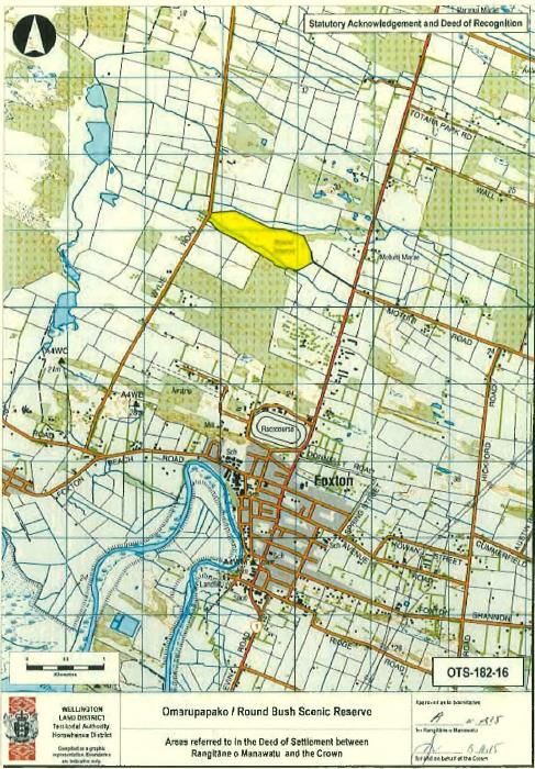
Statutory Acknowledgment for the Omarupapako / Round Bush
Scenic Reserve
Statutory Area
The area to which this statutory acknowledgement applies is the Omarupapako / Round Bush Scenic
Reserve, as shown by OTS-182-16.

Statement of Association
Preamble
Under section 29 of the Rangitāne o Manawatu Claims Settlement Act the statement, the Crown
acknowledges the statement of association made by Rangitāne o Manawatu of their particular
cultural, spiritual, historical, and traditional association with the Omarupapako/ Round Bush Scenic
Reserve.
Rangitāne o Manawatu cultural, spiritual, historical, and traditional association with the
Omarupapako / Round Bush Scenic Reserve

The Reserve is an isolated area of bush, kahikatea (white pine) atop sand dunes about three miles
north of the Manawatu River Estuary. Being part of the coastal dune sequence the Reserve was
noted on early surveys as an area of bush named Omarupapako. The site was occupied seasonally
by Rangitāne o Manawatu for the gathering of kai and other nearby marine resources. Some
mystery shrouds the area today. Some Rangitāne o Manawatu hapu consider the area tapu. This is
due to deaths occurring in the vicinity and being associated with the surrounding lakes and the
location of the taniwha that Matangi slayed after settling the coastal Te Piropiro area. The
surrounding area was cultivated and used by Rangitāne o Manawatu and another iwi for gathering
kiekie and eel. The dune lakes that once existed in the area were also a plentiful supply of eel for
Rangitāne o Manawatu and the Kurahaupo iwi, who both recognised Omarupapako as a prominent
marker (dune) in the landscape. The area between Omarupapako and Himatangi was known as Te
Piropiro.
Omarupapako/Round Bush is the largest and one of the most important dune forest remnants
on the lower North Island west coast. It was selectively logged and partially drained in 1918.
The Manawatu District Council planted the south-eastern part of the reserve in pine trees, and
removal of these was completed in 2000 and restorative planting undertaken. The reserve is fenced,
however vegetation damage and wallowing is caused by sambar deer. The reserve was formally
named 'Round Bush Scenic Reserve' by the Department of Lands & Survey in 1964.

Significant Sites to Rangitāne o Manawatu

 NAME               Description                       Name             Description
 Orua Kai Tawa      Occupied location                 Haku-purua       Lagoon
 Te Humetu          Occupied location                 Okemaha          Lagoon
 Omaru Pa Paku      Bush/ Occupied location           Kai Iwi          Site

As Rangitāne o Manawatu develop their capacity they look forward to the future and the time when
they are fully engaged in upholding the principle of kaitiaki over Omarupapako / Round Bush Scenic
Reserve.
Statutory Acknowledgment for the Tawhirihoe Scenic Reserve
Statutory Area
The area to which this statutory acknowledgement applies is the Tawhirihoe Scenic Reserve, as
shown by OTS-182-17.

Statement of Association
Preamble
Under section 29 of the Rangitāne o Manawatu Claims Settlement Act the statement, the Crown
acknowledges the statement of association made by Rangitāne o Manawatu of their particular
cultural, spiritual, historical, and traditional association with the Tawhirihoe Scenic Reserve.
Rangitāne o Manawatu cultural, spiritual, historical, and traditional association with the
Tawhirihoe Scenic Reserve
Tawhirihoe Scientific Reserve and dune-lands is of historical, cultural, spiritual and traditional
significance to Rangitāne o Manawatu.
Tawhirihoe was an important site and Nohonga area for people travelling along the coast or linking
up with trails following inland to Pukepuke and Puketotara. The Tawhirihoe area has traditionally
been a launching area for waka and Rangitāne o Manawatu fishing station.
Rangitāne o Manawatu also commonly collected pipi along the coastline. The Tawhirihoe area had a
number of large active dunes where traditionally plant and weaving resources such as pingao were
collected.
Tawhirihoe and the adjacent coastline is recognised by the Department of Conservation as a unique
area for its flora, fauna and landforms. The area is also recognised by Rangitāne o Manawatu for this
and the natural resources utilised by the iwi.
The area is one of the last natural coastal (backshore – foredune) environments with a number of
rare sedges and flora. This is one of the last places that the endangered native Katipo spider is
found. The Katipo spider is an important figure within Rangitāne o Manawatu lore.
Over recent years numerous archaeological sites have been discovered unearthing middens and
numerous artefacts providing important insights into the early history and use of the area by
Rangitāne o Manawatu.
As Rangitāne o Manawatu develop their capacity they look forward to the future and the time when
they are fully engaged in upholding the principle of kaitiaki over the Manawatu coastline including
the Tawhirihoe area.
Statutory Acknowledgment for the Ruahine Forest Park
Statutory Area
The area to which this statutory acknowledgement applies is the Ruahine Forest Park, as shown by
OTS-182-18.

Statement of Association
Preamble
Under section 29 of the Rangitāne o Manawatu Claims Settlement Act the statement, the Crown
acknowledges the statement of association made by Rangitāne o Manawatu of their particular
cultural, spiritual, historical, and traditional association with the Ruahine Forest Park.
Rangitāne o Manawatu cultural, spiritual, historical, and traditional association with the
Ruahine Forest Park
Ko Ruahine me nga Tararua te maunga
Ko Manawatu te awa
Ko Kurahaupo te waka
Ko Rangitāne te iwi
The Ruahine Range therefore holds great historical, cultural, spiritual and traditional significance to
Rangitāne o Manawatu, as it is one of two mountain ranges that identify the iwi of Rangitāne.
The southern Ruahine Range is intrinsically connected and related to the activities of the Pohangina
(River and Valley), Te Ahu a Turanga and Wharite as well as the numerous peaks along the Ranges of
which the majority are named after Rangitāne o Manawatu ancestors.
Te Ahu a Turanga is a peak north of the Gorge on the Ruahine Range. The west coast origins of
Rangitāne have their source with the Aotea waka which landed at Aotea Harbour, just north of
Taranaki. The Aotea waka was captained by Turi, who settled in the Patea District of southern
Taranaki and eventually had a son named Turangaimua or more commonly, Turanga. Turangaimua
settled in the Manawatu after marrying a Rangitāne o Manawatu woman, Parehuia. At some time
after his marriage, Turangaimua journeyed to Tamaki Nui a Rua and Ahuriri, and joined with
Rangitāne o Manawatu in fighting the local iwi. Unfortunately the seemingly defeated Ahuriri iwi
were not entirely vanquished and the Turangaimua group were overrun at a saddle on the Ruahine
Range, just north of Te Apiti. Turangaimua was killed in the ensuing battle, along with several
Rangitāne o Manawatu Chiefs. The slain were heaped in a mound and the wāhi tapu site was named
Te Ahu a Turanga, the mound of Turangaimua, at the entrance to the mountain Range. Soon after
the battle in which Turanga was slain, his Rangitāne wife, Parehuia, bore him a daughter named
Ruahine. Her name was subsequently bestowed on the mountain Range.
Wharite is one of the most prominent peaks in Rangitāne o Manawatu rohe. Wharite was inhabited
by Iti a Tohunga from the Ruakawa Pa area below. The Tohunga was banished to the peak due to his
small stature and disfigurements however Rangitāne o Manawatu still consulted him for his
knowledge related to environmental matters. The peak was named after him becoming Whare-Iti.
More recent interpretation also referred to an adjacent area being known for the preparation of titi
hence it becoming confused with the name Whare-titi.
Very little was known about the state of the Ruahine Range and its native vegetation.
Geomorphically the Ruahine Range has only been altered in defined areas by agricultural practices of
the last century. However the lower areas have been damaged from forest removal causing massive
land movements.
Many of the native species and resources found in the Pohangina Valley were also found and
gathered in the ranges. Traditionally the Hinau, Rata and hebe berries and selected other native
trees were collected for food resources. Particular flowers were also gathered from the tussock
land/sub-alpine areas in the range and converted into perfumes. Plants such as the Keikei Tangiau
were used as rongoa while plants such as the supple jack was used in construction particularly for
tuna weir. The extinct highly valued taonga species, the huia was common in the ranges being
collected and traded nationally.
Significant Sites for Rangitāne o Manawatu

 NAME                  DESCRIPTION                     NAME                    DESCRIPTION
 Apiti                 Occupied location               Tukupari                Peak
 Apiti Te Anaowiro     Occupied location               Wairarapa               Occupied location
 Maharahara            Peak                            Ahuriri                 Track
 Oruahiore             Peak                            Te Ahua Turanga         Peak
 Otumore               Peak                            Te Hekenga              Peak
 Taumatatana           Peak                            Wharite                 Peak
 Te Wharau             Occupied location               Whangai                 Range
 Tirahe                Peak

As Rangitāne o Manawatu develop their capacity they look forward to the future and the time
when they are fully engaged in upholding the principle of kaitiaki over the Ruahine Forest Park.
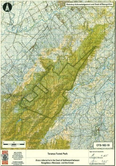
Statutory Acknowledgment for the Tararua Forest Park
Statutory Area
The area to which this statutory acknowledgement applies is the Tararua Forest Park, as shown by
OTS-182-19.

Statement of Association
Preamble
Under section 29 of the Rangitāne o Manawatu Claims Settlement Act the statement, the Crown
acknowledges the statement of association made by Rangitāne o Manawatu of their particular
cultural, spiritual, historical, and traditional association with the Tararua Forest Park.
Rangitāne o Manawatu cultural, spiritual, historical, and traditional association with the
Tararua Forest Park
Ko Ruahine me nga Tararua te maunga
Ko Manawatu te awa
Ko Kurahaupo te waka
Ko Rangitāne te iwi
The Tararua Range holds great historical, cultural, spiritual and traditional significance to Rangitāne o
Manawatu, as it is one of two mountain ranges that identify the iwi of Rangitāne.
The Tararua Range was initially created or “fished up” by Maui and carved into its current shape by
his brothers. It then became the exposed backbone of the fish of Maui (Te Ika A Maui). For
Rangitāne o Manawatu traditions such as this, represent the significant links between the
cosmological world and the modern world, which have shaped Rangitāne as aniwi.
The name Tararua was bestowed on the mountain range by the Rangitāne o Manawatu tupuna
Whatonga. Whatonga who was a great explorer, travelled to the Manawatu via Waka along the
West Coast from the South Island. Following his exploration of the Manawatu, he returned to
Heretaunga, to his wife Hotuwaipara, who had bore him a son named Tara. Whatonga named the
mountain Range (and twin peaks near Mitre Peak) which dominated the landscape within his rohe,
Tararua, after his first born son.
Over time the range developed its own persona and place within Rangitāne o Manawatu cultural
and spiritual belief system as a highly significant geomorphological feature in the landscape. The
Tararua Range became respected and revered as a significant site and was regarded as a place
occupied by past ancestors. These ancestors formed the peaks of the Range and were situated in a
position similar to those Rangatira and Kaumatua that sit on the paepae in the front of a Marae.
Due to this, parts of the Range were not accessible while other parts were used for spiritual and
ritualistic practises.
The name of the Tararua, the tracks located within it, the sources of many rivers which begin there,
the great abundant sources of mahinga kai located within it and the various names bestowed on
areas within the Tararua, reinforce the tribal identity of Rangitāne o Manawatu and the continuity of
Rangitāne o Manawatu through the various generations. They are the living evidence that has
shaped Rangitāne o Manawatu as an iwi and bestowed upon them as one of the kaitiaki of the
Tararua Range.
The Tararua mountain range contains many tracks which link Rangitāne o Manawatu with Rangitāne
whanaunga who live in Tamaki Nui a Rua and Wairarapa. These include the tracks that lead from
Raukawa Pa on the eastern bank of the Manawatu River, to the Wairarapa, whilst another lead from
the fortified Pa site of Te Motu a Poutoa (now known as ANZAC Park) by way of what is now known
as the Pahiatua-Aokautere Road onto Forty Mile Bush, in the Wairarapa. Near Puketotara, which
now links the Te Awe Awe roads on the eastern and western sides of the Tararua Range, was the
track known as Kaihinau, named after the Chief of Tuwhakatupua Pa. From Wairarapa there was a
track that followed the Kahuterawa Stream which Rangitāne o Wairarapa would use to visit
Rangitāne o Manawatu at Kairanga.
Located along the Tararua Range, are significant peaks which Rangitāne o Manawatu would light
fires to send signals to their whanaunga in times of battle. One significant part of the Tararua Range
(currently the Tararua Forest Park) originally referred to as “Tihi-Pakirakira” became established as
an area for crossing the Range and gathering resources, signal fires and small settlements were
established and the area was then known as Arawaru. On Arawaru and Te Apiti some of the most
unique flora in the Manawatu is found.
Another significant peak which Rangitāne o Manawatu identify with, is Hanga-o-hia-tangata, which
means the place that caused surprise to man, as it is from this peak along with Pukematuwai and
Mount Lancaster, that are the sources for the Mangahao, Ruamahanga, Waingawa, Waiohine Park,
Otaki River and the southern branch of the Ohau River. The Tararua therefore, gives life to the
mauri which flows throughout the rohe of Rangitāne o Manawatu, and provided the link between
the cosmological spiritual world and the tupuna of Rangitāne o Manawatu. Another significant peak
is Ngāwhakaraua Peak, which is a transliteration of the Rangitāne Pa, Ngāwhakaraua situated near
the Manawatu River at Opiki. Mairehau peak is named after the Rangitāne hapu Ngāti Mairehau.
The Tararua Ranges not only provided a transport route for Rangitāne o Manawatu and a means of
communication in times of battle, it also contained an abundant source of mahinga kai and shelter
for Rangitāne o Manawatu. These included a considerable number of bird species, such as kiwi,
kokako, weka, kereru, kaka, hokio, kotuku and huia. Kiwi, kotuku and huia, were a taonga species
for Rangitāne o Manawatu, so they were never hunted for food and their feathers were used to
make korowai.
The legendary “hokio” were also found in the Range. So too it is believed the kotuku was a
distinguished, kaitiaki like visitor to wāhi tapu lakes in the Range such as Hapuakorari.
The dense forest which contained the likes of totara, kahikatea and miro provided many berries
which were also a valued mahinga kai. These included the hinau, miro and karaka berries, the
mouku fern and pitau whilst the many rivers and streams provided tuna, waikoura, waikakahi and
other freshwater species.
The Tararua Range also provided many plants that Rangitāne o Manawatu used for Rongoa purposes
and the location of these plant sites of which few remain, stay within the traditional history of
Rangitāne o Manawatu.
The waters that flow from the Tararua are sacred and provide the mauri that flow through the
Manawatu. The tapu associated with the Tararua is a critical dimension of Rangitāne tribal value
and it is the source of the power over life and death, which the Tararua Range possesses.
Significant Sites for Rangitāne o Manawatu

As Rangitāne o Manawatu develop their capacity they look forward to the future and the time
when they are fully engaged in upholding the principle of kaitiaki over the Tararua Range.
Statutory Acknowledgment for the Manawatu River and Tributaries

Statutory Area
The area to which this statutory acknowledgement applies is the Manawatu River and its tributaries,
as shown by OTS-182-20.

Statement of Association
Preamble
Under section 29 of the Rangitāne o Manawatu Claims Settlement Act the statement, the Crown
acknowledges the statement of association made by Rangitāne o Manawatu of their particular
cultural, spiritual, historical, and traditional association with the Manawatu River and its tributaries.
Rangitāne o Manawatu cultural, spiritual, historical, and traditional association with the
Manawatu River and its tributaries
The Manawatu River is of immense historical, cultural, spiritual and traditional significance to
Rangitāne o Manawatu. The Manawatu River was the main route for travel and communication for
Rangitāne o Manawatu with settlements along the margins of the river.
Rangitāne o Manawatu has a rich belief system and structure that has developed over hundreds of
years of occupation. The belief system developed a number of spiritual and ritualistic practices that
occur at different times and locations along the Manawatu River. A large number of these practices
have disappeared due to the introduction of European culture and Christianity. The Manawatu River
was created through the spirit of Okatia, who gave life to a totara growing on the slopes of the
Puketoi Range in the Hawkes Bay. The totara made its way to the mountain ranges of the Ruahine
and Tararua, and as it forced its way through the ranges, it created the Manawatu Gorge and the
Manawatu River as it made its way out to sea. For Rangitāne o Manawatu traditions such as this,
represent the significant links between the cosmological world and the modern world, which have
shaped Rangitāne o Manawatu.
The name Manawatu was bestowed on the River by the Rangitāne Tohunga Haunui a Nanaia, over
six hundred years ago. Whilst searching for his wife, Waireka, Hau travelled down the West Coast of
the North Island crossing and naming many waterways. When he reached a turbulent flowing river
which caused his heart to sink as he thought he may not be able to cross it and continue his search,
he called the River Manawatu.
The spiritual connection that Rangitāne o Manawatu have with the River is evidenced by the building
of churches along the River such as the Church Turongo Hiha. It was here that an aged Rangitāne
Chief related to the assembled people that he had had a momentous dream the previous night. He
dreamed that he was standing at the foot of two great totara trees somewhere on the bank of the
Manawatu River and that these trees were talking to each other. The first tree said, “Do you know
who I am?” “No,” was the reply. “I am whangarae (the god of the forehead),” said the first. “Oh. Do
you know who I am?” asked the second. “I am whangaihu (the god of the nose).” And they both
chanted an incantation. Hiha remembered this karakia and recited it to the assembly. So, on an
appointed day, three large canoes made their way up the River to search for the trees. They finally
discovered them at a place called Kairanga, near where the Linton Army Camp now stands. The
trees were felled and floated down the River to Moutoa where they were pit-sawn into timber. The
timber produced by these two great totara was sufficient not only to build the Church but also the
furnishings, including a beautifully carved altar. The church was subsequently bestowed with the
name Turongo.
Located within the Manawatu River, are many taonga of significance to Rangitāne o Manawatu.
There is Te Au-rere-a-te-Tonga, the flowing current of the south, Te Au-nui-a-Tonga, the waterfall
located in the gorge, as is the tapu rock Te Ahu a Turanga, which remains visible even in the highest
of floods.
There were many Rangitāne o Manawatu kaitiaki guardians of the River. These included Peketahi
who lived at Puketotara, and Whangaimokopuna who lived near Hotuiti, also known as Motuiti until
he was banished and now lives up in the hills at Raekatia. Whenever Rangitāne people from the
lower reaches of the River visit that area, a mist descends which is Whangaimokopuna weeping for
his old friends.
Rangitāne o Manawatu practised a number of rituals along the Manawatu River where its resources
were utilised. These sites later developed into tapu or wāhi tapu sites. Most if not all of these sites
have now been lost (in private or local government ownership) or destroyed due to engineering
works.
The Manawatu River and its large number of waterways provided the main highway for Rangitāne o
Manawatu and as well as being a mahinga kai in its own right, it fed into the land based mahinga kai.
Along the Manawatu River, were located numerous Rangitāne o Manawatu Pa, which have now
become one with the River and their locations and the myriad of trails used by Rangitāne o
Manawatu, remain an integral part of our traditional history. The traditional mobile lifestyle of
Rangitāne o Manawatu, led to their dependence on the Manawatu River and its resources.
Because of the long history of the Manawatu River in providing the highway and mahinga kai to
Rangitāne o Manawatu, both on a temporary and permanent basis, there are numerous urupa, wāhi
tapu and wāhi taonga associated with the River and Rangitāne o Manawatu. These associations hold
the memories, traditions, victories and wairua of Rangitāne o Manawatu tupuna, and many locations
therefore, remain unknown to the wider public.
The most significant quality that flows through the Manawatu River is its mauri which binds all the
physical, traditional and spiritual elements of all things together, generating, nurturing and
upholding all life. That mauri is the most crucial element that binds Rangitāne o Manawatu with the
Manawatu River, and that relationship has consisted for over seven hundred years of unbroken
occupation.
The interconnected waterways of the Manawatu form a dendritic pattern across the landscape. The
mauri supplied from the mountains and areas in the gorge is transported along these waterways to
nourish and feed the land and everything living on the land. The Manawatu River for Rangitāne o
Manawatu is seen as the main artery in this network containing the strongest and greatest amount
of mauri. If any activity that disrupts the flow of the waterway or pollutes the watercourse it is seen
as having a negative impact on the mauri which then in turn has a direct negative impact on
Rangitāne o Manawatu land and people.
Rangitāne o Manawatu occupation of the Manawatu River continues today after several hundred
years. To secure the natural resources needed to sustain Rangitāne o Manawatu and protect the
people from neighbouring iwi, Rangitāne o Manawatu developed a number of Pa in strategic
locations. These Pa were situated near their most valuable natural resources as well as in strategic
positions, particularly along the Manawatu River.
Rangitāne o Manawatu occupied a large area of the Manawatu and developed into a number of
whanau based hapu that were responsible for certain geographical areas and natural resources
along the Manawatu River. Each hapu interacted with the river and the river flowed through each
hapu rohe. These are outlined:
Ngāti Mairehau (Also known as Ngāi Tuahuriri)
Occupied the east bank of the Manawatu River around Turitea to Tokomaru and over the Tararua
Ranges to Pahiatua. More specifically along the northwest bank between Ngāwhakaraua and
Awapuni.
Ngāti Hineaute
Occupied the land along the Manawatu River from Te Apiti to the northern boundary of Palmerston
North City.
Ngāti Rangitepaia (Also known as Ngāti Rangi)
Were based on land from the southern boundary of the city to the confluence of the Oroua and
Manawatu Rivers.
Ngāti Rangiaranaki
Shared the riverbank of the Manawatu River from Te Apiti to Palmerston North with Ngāti Hineaute.
Ngāti Tauira
A shared Rangitāne – Ngāti Apa hapu located around the Oroua River above Mangawhata extending
to the Rangitikei River and coastal area.
Ngāti Te Kapuarangi
Occupied the upper Manawatu catchment and Pohangina area. The Manawatu River, its
geomorphology and human geography can be divided into distinct reaches. Each reach, having a
unique environment, meant Rangitāne o Manawatu interacted with that environment accordingly.
Te Apiti (“The Gorge”)
This part of the River was recognised for its spiritual connections and significance. As identified the
Gorge was carved by a great spirit Okatia cutting its way through the active rising mountain range,
the backbone of Te Ika A Maui, allowing the waters to flow from east to west. This active mountain
range is a source of mauri for Rangitāne o Manawatu hence the mauri is then transported by the
waters of the River to the rest of the rohe. The majority of the sites of significance in this stretch of
the River are related to the identification and preservation of mauri in the River.
Otangaki – Papaeioa (Palmerston North) – Puketotara
Geographically this stretch consisting of a steep, gravely bed with defined flood plain contained a
number of strongholds and Pa. These Pa were used in times of attack as well as to prepare warriors
for battle. These Pa also controlled the entrance to the Gorge as well as various crossings over the
Ranges.
This stretch of what used to be clear clean water was also used seasonally to gather resources and
foods from various locations in the Ranges as well as along the River and used in ritual practises at
the related Pa.
Puketotara was the largest Pa in the area and the central point of the Rangitāne rohe. This site was
home to all Rangitāne and numerous events occurred there that determined the future of Rangitāne
o Manawatu.
Puketotara – Te Papa Ngaio (Shannon/Opiki/Foxton)
This stretch of the River was the most intensively populated and utilised section of the River for
Rangitāne o Manawatu. In this area were numerous Rangitāne o Manawatu papakainga and kainga
as well as large areas of cultivations. This part of the Manawatu River was a highway for a large
amount of traffic for travel, communication and to access the rich supply of resources contained
with the lowland forests and swamps. Associated with the intense population were also numerous
sites of ritualistic practice and worship.
Ngāwhakaraua was a large Pa situated on a great horseshoe bend of the Manawatu River, slightly
upriver and east of the river’s confluence with the Oroua River, and one mile south of the Opiki toll
bridge. The pa was occupied by Rangitāne o Manawatu and covered 86 acres of land. The principal
buildings were, Te Ahu A Turanga Church, moved from Puketotara c.1879 and destroyed by fire
c.1907, although replaced with a smaller building and a wooden whare runanga, ‘Kotahitanga.’
Kotahitanga represented the kaupapa of unity. Ngāwhakaraua was in use as a mahinga kai for some
time before the establishment of a Pa in the locality, which indicates there were sufficient food
resources on the surrounding land to sustain a resident population.
Te Papa Ngaio – Okatia Beach (Opiki to Foxton Beach)
The coastal area of the Manawatu River was extremely important to Rangitāne o Manawatu. Not
only was this area a rich source of kai moana and other natural resources but Rangitāne o Manawatu
were also able to participate in trade with other iwi and groups travelling along the coastline. One of
the greatest resources in this area was the Tapuiwaru swamp (now referred to as the Moutoa
floodway). It was also a very important area as it was the main access point to the Manawatu River
and to the East Coast of the North Island.
Rangitāne o Manawatu - Significant Sites
Along the Manawatu River in the Rangitāne o Manawatu rohe there are 185 recorded sites of
significance. The majority of these sites of settlement and occupation and would have had
permanent structures associated with them.
Approximately ten of these sites were substantial cultivations or eel weirs that were recorded in
historical accounts.
A number of mahinga kai, traditional food gathering areas, and nohoanga, areas of seasonal
settlement were located along the River. However a number of these have been destroyed and lost
due to engineering works and the moving of the watercourse of the River as the result of
engineering works. Over the last one hundred years with constant land use change Rangitāne o
Manawatu cultural landscape and its traditional use has been destroyed and lost.
Significant Sites Associated with the Manawatu River
As Rangitāne o Manawatu develop their capacity they look forward to the future and the time when
they are fully engaged in upholding the principle of kaitiaki over the Manawatu River.
Statutory Acknowledgment for the Rangitikei River
Statutory Area
The area to which this statutory acknowledgement applies is the Rangitikei River, as shown by OTS-
182-21.

Statement of Association
Preamble
Under section 29 of the Rangitāne o Manawatu Claims Settlement Act the statement, the Crown
acknowledges the statement of association made by Rangitāne o Manawatu of their particular
cultural, spiritual, historical, and traditional association with the Rangitikei River.
Rangitāne o Manawatu cultural, spiritual, historical, and traditional association with the
Rangitikei River.
The Rangitikei River is of historical, cultural, spiritual and traditional significance to Rangitāne o
Manawatu. The Rangitikei River is significant as marker of the boundary of the rohe. The north
western boundary of Rangitāne o Manawatu rohe stretches to the south bank of the Rangitikei River
and separates Ohakea/Tangimoana (including the Tangimoana Forest) from Bulls. The rohe
boundary continues up the Rangitikei River where numerous historical sites existed. The River like
the majority along the coast was named by Haunui a Nanaia. Rangitikei has been literally translated
to be the day of the long stride however it refers to the good progress that was made by Haunui
during his day of travels before he encountered the River.
The Rangitikei River and the district’s waterways were a vital means of gaining access to settlement,
cultivation and mahinga kai sites within the rohe of Rangitāne o Manawatu. During the arrival of
Europeans the Māori were noted in the Rangitikei area for travelling up and down the River by waka
staying at Pa sites along the way. It is not coincidental, then, that almost all Rangitāne o Manawatu
Pa and cultivations were situated immediately adjacent to, or within sight of, prominent and
navigable waterways. The soil was fertile in such localities, transport to mahinga kai and other
settlements was significantly aided by River access and rapid communication between Pa was
possible. Early European surveys record large populations at settlements along the River e.g. Te
Awahoe, Mangamahoe, Maramaihoea, Ohinepuhiawe, Matahiwi and Poutu.
Traditionally the Rangitikei River provided an essential means of communication and trade. It is
significant as it provided access to the central North Island which was important for trade. During
the migration of foreign iwi the River provided an easy method to gather and mobilise warriors from
surrounding areas.
Parewanui is one of the main Pa of the area on the Rangitieki River. The Pa site was where the
Rangitikei Manawatu Block was acquired by the Crown in 1866. Descendants of Ngāti Tauira or
Rangitauira, as they were also known, and who were comprised of Rangitāne o Manawatu and
another iwi rest at the Parewanui Urupa next to Wheriko Church. It was here at Parewanui the
famous prophetess, Mererikiriki (II) formed the Maramatanga movement and provided the people
with her spiritual healing powers and visions. She was described as a Tohunga O Te Wairua Tapu,
and Parewanui the Holy Ghost Mission.
Mererikiriki was the grand-daughter of Rangitāne o Manawatu Chief Tame Te Panau and Maata
Momo (who was a renowned spiritual healer in the Rangitikei Manawatu during the early 1800s).
When Christianity arrived in the area, the Church of England linked three churches to preach the
gospel. Wheriko at Parewanui, one at Turakina, and the third, Rangimarie at Rangiotu.
At Parewanui in 1850, Te Hirwanui Kaimokopuna and other Rangitāne o Manawatu Rangatira also
meet with Crown representatives to first discuss the purchase of the land in the Manawatu.
There are a number of native trails or tracks between the settlements and the Rangitikei and
Manawatu Rivers. Along the River were numerous cultivated areas of Kowhai and Karaka that
attracted a multitude of numerous native bird species. Along the course of the River the native
forest comprised totara, tawa, titoki and a few kahikatea. The River was plentiful in native
freshwater species of eel, crustaceans, and shellfish and notably ducks. While at the river mouth
numerous shark and kahawai were caught. The River was previously more sinuous and defined to a
single channel.
Eels were caught in streams and lagoons, cultivations were established and birds were snared. Even
if sufficient food supply could not be gained within the Rangitikei area during certain seasons it was
not unusual for hunters to travel long distances to favoured snaring places.
Significant Sites for Rangitāne o Manawatu

As Rangitāne o Manawatu develop their capacity they look forward to the future and the time
when they are fully engaged in upholding the principle of kaitiaki over the Rangitikei River.
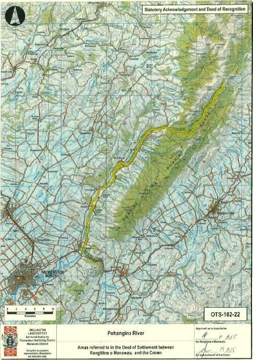
Statutory Acknowledgment for the Pohangina River
Statutory Area
The area to which this statutory acknowledgement applies is the Rangitikei River, as shown by OTS-
182-22.

Statement of Association
Preamble
Under section 29 of the Rangitāne o Manawatu Claims Settlement Act the statement, the Crown
acknowledges the statement of association made by Rangitāne o Manawatu of their particular
cultural, spiritual, historical, and traditional association with the Pohangina River.
Rangitāne o Manawatu cultural, spiritual, historical, and traditional association with the
Pohangina River
The Pohangina River is of historical, cultural, spiritual and traditional significance to Rangitāne o
Manawatu. The Pohangina River has its source in the western foothills of the Ruahine Range, Te Ana
O Whiro, and flows close to the Range until it merges with the Manawatu River at the western end
of Te Apiti.
Through Rangitāne o Manawatu traditions such as waiata, korero and whakairo the area and River
means ‘ulcerated night’, ‘Po’ meaning night and ‘hanga’ meaning ulcerated. This suggests that the
valley had been a place where bloodshed had occurred between Rangitāne o Manawatu and their
enemies. Thus this was a place of darkness and there was a degree of fear attached to the area
because of bloodshed. The second level of meaning was the very ulcerated or dissected nature of
the landscape itself, lots of little streams with valleys cutting down in to the area. It is a very dark
area that tends to get a lot of cloud. It has its own microclimate, being close to the foothills of the
Ruahine Range thus the very climate itself gives a separate identity to the area. The area was
respected and was considered a tapu area to visit. Some oral traditions indicate the areas in the
valley were only visited in certain times of the year with tohunga to collect treasured natural
resources and Rongoa.
In the Pohangina Valley, totara intermingled with matai along the well-drained riverbanks, and small
areas of black beech were present across the valley floor. Amongst journeys to snare birds, catch
fish and gather berries, Rangitāne o Manawatu from the lower reaches of the Manawatu River came
into the Pohangina Valley in order to fell totara, which were floated downriver and hulled to create
waka.
This district during the pre-Pakeha period was an abundant source of food, bore a bountiful variety
of vegetation, bird and freshwater species, and in addition was a geographically diverse landscape
closely aligned both in terms of origin and location.
According to Rangitāne o Manawatu the Pohangina and Oroua valleys were as heavily settled as the
lower Manawatu and rich with a variety of resources. Prior to the 1900’s very few Europeans
ventured into this area yet Pohangina Valley settlers of 1891 noted,
“Māori up here in considerable numbers just now, engaged in the interesting pursuits of pighunting
and eel-catching, and when they are not eating or sleeping, they fill in time in collecting fungus.”
William Colenso, a Missionary for the Church Missionary Society, crossed the Ruahine Range from
east to west at Te Ana O Wiro, in the company of two guides from the Pohangina Valley in 1848
making note of Rangitāne o Manawatu settlement in the valley. During their journey through the
Valley they discovered a very small kainga, either Te Hirau or Te Hara in which seven adults and two
children were resident. J.T. Stewarts survey plan of the Manawatu (1867) identifies numerous
Rangitāne o Manawatu settlements along the Pohangina River specifically the Kiekietengaio
settlement, Tikorangi, Anapatiki, Ahimaramara and the Manga ti paka stream near the existing
Pohangina township and Pohangina Reserve, and Toutauirangi near Totara Reserve.
There is ample historical evidence of battles involving Rangitāne o Manawatu occurring in the
Pohangina Valley. The site is significant as the site of many battles between Rangitāne o Manawatu
and neighbouring iwi. While Rangitāne o Manawatu defeated neighbouring iwi in the valley many
Rangitāne o Manawatu were killed in the process resulting in the area being revered by future
generations. The tapu status of the Pohangina Valley appears to have endured, at least for some
time, after Pakeha settlement of the area. A battle occurred between Rangitāne o Manawatu and a
neighbouring iwi who crossed the Ruahine Range via Te Ahu a Turanga and entered the Pohangina
Valley just north of the present Otangaki. The battle was known as “Te Wai Whakatane o Ngāti
Kahungunu.”
Sites of Significance for Rangitāne o Manawatu

As Rangitāne o Manawatu develop their capacity they look forward to the future and the time when
they are fully engaged in upholding the principle of kaitiaki over the Pohangina River.
Statutory Acknowledgment for the Oroua River

Statutory Area
The area to which this statutory acknowledgement applies is the Oroua River, as shown by OTS-182-
23.

Statement of Association
Preamble
Under section 29 of the Rangitāne o Manawatu Claims Settlement Act the statement, the Crown
acknowledges the statement of association made by Rangitāne o Manawatu of their particular
cultural, spiritual, historical, and traditional association with the Oroua River.
Rangitāne o Manawatu cultural, spiritual, historical, and traditional association with the
Oroua River.
The Oroua River is of historical, cultural, spiritual and traditional significance to Rangitāne o
Manawatu. The histories and traditions of Rangitāne o Manawatu such as waiata, korero and
whakairo outline the connections Rangitāne o Manawatu have with the Oroua River. These histories
link Rangitāne o Manawatu in this area to past generations and with the natural world such as
Ranginui and Papatuanuku.
The Oroua River flows through the centre of Rangitāne o Manawatu rohe with its source originating
from the Ruahine Range. One of the most significant qualities is the mauri that flows from the
central Ruahine Range through the rohe connecting the Range to the wetlands and sand country and
finally to the Manawatu River.
The River provided essential travel and communication from the lower (Opiki Area) Manawatu River
through the bountiful Taonui Swamps to the upper rohe. The River was heavily populated in these
areas such as Mangawhata, Tu Putaangi, Nga Whakaatu and Te Awahuri. The River was also a
mahinga kai in its own right.
Most settlements in this area had associated urupa.
The Oroua River flowed through a variety of environments almost covering a sample of landscape
found within the rohe. Forest cover of matai, rimu, miro and tawa grew from amongst the scrub
throughout its course with areas of forests dominated by kahikatea with pukatea around wetlands
and more sluggish streams. In some isolated locations totara predominated.
Large areas of the lower water course were covered with flax. This fertile land also contained some
of the richest food supplies in the Manawatu Region, with the most desired item being tuna which
could be caught in huge quantities from the waters of the swamps adjacent to the riverbanks and
streams.
Sites of Significance to Rangitāne o Manawatu

As Rangitāne o Manawatu develop their capacity they look forward to the future and the time when
they are fully engaged in upholding the principle of kaitiaki over the Oroua River.
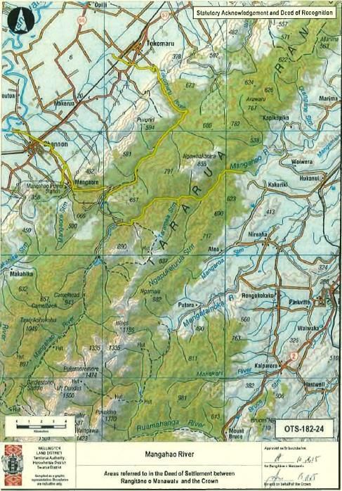
Statutory Acknowledgment for the Mangahao River

Statutory Area
The area to which this statutory acknowledgement applies is the Mangahao River, as shown by OTS-
182-24.

Statement of Association
Preamble
Under section 29 of the Rangitāne o Manawatu Claims Settlement Act the statement, the Crown
acknowledges the statement of association made by Rangitāne o Manawatu of their particular
cultural, spiritual, historical, and traditional association with the Mangahao River.
Rangitāne o Manawatu cultural, spiritual, historical, and traditional association with the
Mangahao River.
The Mangahao River is significant to Rangitāne o Manawatu both as a natural and spiritual resource.
The Mangahao River flows from the central areas, Hanga o hia tangata, in the Tararua Ranges, along
the Ranges, past a number of significant peaks such as Mairehau and Ngāwhakaraua connecting
many of the rivers that then flow to the west and the east. The Mangahao River valley also provided
an important access and route through the Tararua Ranges to the central areas for spiritual purposes
and to gather natural resources. European explorations of the Ranges during the 1900’s have also
uncovered a number of artefacts in the vicinity of this area.
One of the most significant features of the river is the direct connection through the Ranges
connecting many streams to carry Mauri from the ranges to the lowland areas below. However, the
Mangahao River has been heavily altered and dammed during European settlement for industrial
and power generation purposes.
The Mangahao and its distributaries (Tokomaru River and Mangaore Stream) were highly regarded
sources of wai and kai and access ways into the Tararua Ranges.
The Mangahao River has been over time referred to as Moawhanga/Moawanga and
Mongohao/Mangahao. The former names refer to the booming sound the river made through its
course and to the area being a source of Moa that were hunted in the area. Rangitāne (North Island)
also refer to the Mangahao as being a source of (pure) water where the, now extinct, native
freshwater fish (grayling) Upokororo was found in large numbers and gathered.
As Rangitāne o Manawatu develop their capacity they look forward to the future and the time when
they are fully engaged in upholding the principle of kaitiaki over the Mangahao River.
Statutory Acknowledgment for the Coastal Area

Statutory Area
The area to which this statutory acknowledgement applies is the Coastal Area, as shown by OTS-182-
25.

Statement of Association
Preamble
Under section 29 of the Rangitāne o Manawatu Claims Settlement Act the statement, the Crown
acknowledges the statement of association made by Rangitāne o Manawatu of their particular
cultural, spiritual, historical, and traditional association with the Coastal Area.
Rangitāne o Manawatu cultural, spiritual, historical, and traditional association with the
Coastal Area
The coastline within Rangitāne o Manawatu rohe between the Manawatu and Rangitikei Rivers is of
historical, cultural, spiritual and traditional significance to Rangitāne o Manawatu.
The Manawatu Coast has been an integral part of Rangitāne o Manawatu culture, history and
existence with those connections being unbroken for over 700 years. These connections to the
Manawatu Coast and coastal sand dune country have been recorded in waiata, korero and whaikaro.
The coastline or area that was traditionally referred to as Okatia the spirit that created the
Manawatu River resides on the coast. The Holocene dune sequence and unique landscape has also
been a part of Rangitāne o Manawatu identity and spiritual practice. The coastal area is abundant in
archaeological evidence, with over 35 recorded sites.
Rangitāne o Manawatu earliest connections with the Manawatu Coast are recorded by their
Kurahaupo ancestor firstly Kupe who navigated the coastline from the East Coast around Te
Whanganui a Tara and along the Manawatu coastline. One navigational method used was to follow
the migratory birds that seasonally reside in the Manawatu River Estuary. Haunui a Nanaia a
tohunga in search of his wife Waireka also travelled the coastline naming the rivers on his journey.
Whatonga, the grandfather of Tanenuiarangi (Rangitāne) inter alia have first travelled in the
Manawatu after journeying up the coastline from Te Whanganui a Tara. The area was so rich in
natural resources that he and his descendants settled in the area with the area becoming known as
Te Taperenui O Whatonga or the great supply of food for Whatonga. Te Waewae- Kapiti-o-Tara-
raua-ko-Rangitāne or Kapiti Island also became an important connection to the Coastline and
Rangitāne o Manawatu, not only providing an important marine navigational marker but also an
important place for spiritual and ritualistic practices.
The Coast following this time became an important route for trade and communication connecting
both the South (Te Waka a Maui) and North Island (Te Ika a Maui). The Manawatu coastline became
a place of great wealth and strategic importance for Rangitāne o Manawatu between the Manawatu
and Rangitikei Rivers for trade, transport and communication to the East Coast and Central North
Island.
The most significant areas of settlement along the Coast were Te Wharangi and Te Papa Ngaio at the
mouth of the Manawatu River. Te Wharangi (meaning - broad flat place) was an area used for river
crossings and as a waka mooring for ocean going vessels bringing back fish. Te Wharangi was a
mahinga kai utilised seasonally by Rangitāne o Manawatu to catch whitebait, flounder and other
tidal river species. Rangitāne o Manawatu provided river crossings for Europeans upon their arrival
and settlement. Te Papa Ngaio was a large Pa on the southern bank of the Manawatu River opposite
Te Wharangi. During Wakefield’s 1840 visit to the district he journeyed to the Manawatu and
encountered “a body of natives” at the river mouth. According to Wakefield’s account of the
journey, the Māori were unable to supply the New Zealand Company agent with any provisions as
“they were from a settlement near the gorge of the Manawatu” however he noted numerous Pataka
and storehouses of theirs along the Coast.
Himatangi the next main area was an important source of a variety of foods for Rangitāne o
Manawatu. The larger area was known as Te Piropiro. The correct hyphenation of the word is said
not to be Hima-tangi but Hi-matangi, and thereby provides a different tale. “Hi” means to fish, and
Matangi was a Chief who lived in the mystic past in the Mohaka District of the East Coast. The name
also refers to Matangi capturing and slaying a Taniwha in the area upon his settlement. Himatangi
was also famous for the abundance of eel and birds available from the wetlands and dune lakes in
the area, namely Lakes Kaikokopu, Omanuka and Pukepuke. Numerous traditional eel weir were
constructed as well as island Pa, such as Oahura, only accessible by waka and used in a time of battle
as a refuge.
The next main area was the mouth of the Rangitikei River being of strategic importance to Rangitāne
o Manawatu as it provided an entrance to the Rangitikei and Central North Island. This importance
lead to the heavy settlement of the area with Pa, Kainga and Papa Kainga in the lower stretches of
the Rangitikei River to the sea. The most famous of these settlements was Parewanui and the
central point of all Pa and cultivations/farms of the area. This area was frequented by many of the
Crown’s representatives with many meetings being held there to progress the sale of lands in the
Rangitikei and the Manawatu as well as plan for the settlement of the region.
The name “Tangimoana” was allocated to a small coastal area. Traditionally the dune area around
the town was referred to as Te Ruahine. The most recognised area or settlement (nearest to the
present day township) was Tawhirihoe. Tawhirihoe was originally a Pa, then a mahinga kai, and
cultivation, and finally the flat now known as Scott’s Ferry and Tangimoana. More recent erosion
and river works altered the course of the River rapidly and drastically and made all settlement in that
area hazardous.
The areas between these main centres were cultivated and heavily used particularly to grow
potatoes and fern root. Areas such as the coastal lagoons of Pukepuke, Omanuka, Kaikokopu,
Okemaha and Haku Purua were important sources of food (particularly Tuna) and seasonal
settlement.
The dune geomorphic landscape has been relatively unaltered. However within these features the
native forest and cultural cultivations have disappeared apart from two Department of Conservation
reserves. The culturally significant feature of this coastline was the wetland areas and small swallow
dune lakes that were found between large dune structures. Within these lakes and the freshwater
streams that feed them, were a variety of native fish and eel as well as birds.
The most culturally significant feature of the coastline was the shellfish that were found in areas
where the freshwater met the ocean. The most common were; Toheroa/Tohemanga (Paphies
ventricosa); Pipi (Paphies australis); Tuatua (Paphies subtriangulata); Tuangi (Chione stutchbury);
and surf clams (Paphies donacina, Spisula aequilatera, Mactra murchisoni, Mactra discors, Dosinia
anus).
Along with these shellfish species were also the range of ocean fished caught offshore as well as the
occasional whale.

Significant Sites for Rangitāne o Manawatu
You can also read