Draft Environmental Values for Water Quality in the Thomson and Barcoo Catchments, Queensland - July 2013
←
→
Page content transcription
If your browser does not render page correctly, please read the page content below
Draft Environmental Values for Water Quality in
the Thomson and Barcoo Catchments,
Queensland
July 2013
Acknowledgements
Desert Channels Queensland would like to acknowledge and thank the members of the general
community who provided their input and comments throughout the current consultation process.

Desert Channels Queensland would also like to acknowledge the assistance, guidance and support of
the Healthy Waters Policy staff of the Department of Environment and Heritage Protection.

The Queensland Government is acknowledged for provision of funds through Department of
Environmental Protection Agency under the Regional NRM Program Investment for 2012/13.

Desert Channels would like to acknowledge personnel involved in the consultation process,
specifically Helen Cross and Sue Akers.
Draft environmental values for the waterways of the
                    Thomson and Barcoo catchments, Queensland

Contents
  Acknowledgements............................................................................................................................. 2
  Contents .............................................................................................................................................. 3
  Introduction ........................................................................................................................................ 4
     Purpose of this report ..................................................................................................................... 4
     The Lake Eyre Basin and Cooper Catchment .................................................................................. 4
     The Thomson and Barcoo catchments ........................................................................................... 5
     Legislative context .......................................................................................................................... 6
     Local water quality guidelines......................................................................................................... 6
     Progress to date .............................................................................................................................. 7
     What’s next? ................................................................................................................................... 7
     Environmental values...................................................................................................................... 7
  Draft environmental values ................................................................................................................ 9
     The process ..................................................................................................................................... 9
     Assignment of environmental values to subcatchments of the Thomson and Barcoo catchments
     ...................................................................................................................................................... 10
     Aquatic ecosystem protection levels ............................................................................................ 19
     Outcomes ...................................................................................................................................... 19
  References ........................................................................................................................................ 21
  Appendix

                                                                                                                                                            3
July 2013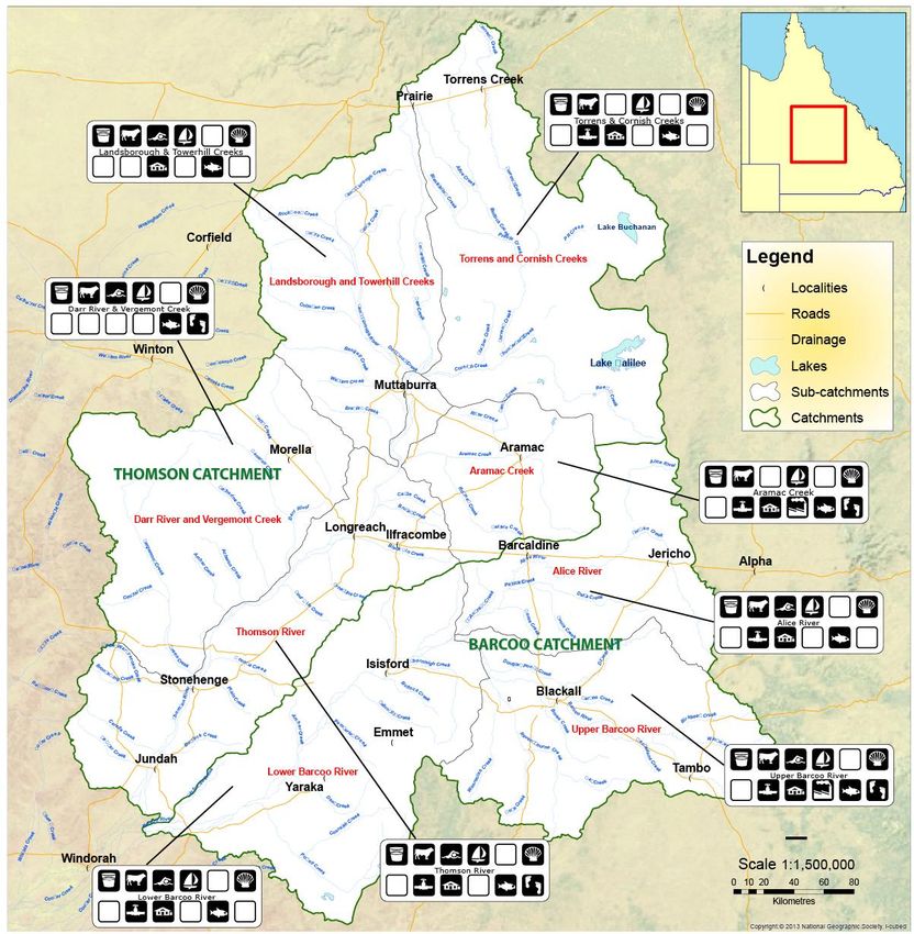
Draft environmental values for the waterways of the
              Thomson and Barcoo catchments, Queensland

Introduction
Purpose of this report
This report describes how the proposed draft environmental values were established for the
waterways of the Thomson and Barcoo catchments and describes the draft environmental values
themselves. This information has been prepared to assist the community to provide feedback on the
proposed draft environmental values for the catchments so that these values can reflect the way the
community values the water of the catchments and so these environmental values can be
appropriately protected through the Government’s scheduling process managed by the Department
of Environment and Heritage Protection.

You can provide your feedback on the proposed draft environmental values at www.dcq.org.au

Once received the community’s feedback will be used to update the draft environmental values for
recommendation to the Department of Environment and Heritage Protection for scheduling in the
Environmental Protection (Water) Policy 2009 as discussed further under the Legislative context
heading below.

The Lake Eyre Basin and Cooper Catchment
The Lake Eyre Basin (LEB) is one of the largest internally-draining systems in the world, covering just
under one-sixth of Australia. The climate is typically hot and dry with highly variable rainfall. Except
for the occasional very large floods, water in the LEB rivers evaporates in the drying wind of the arid
landscape before it reaches Lake Eyre, leaving only the occasional waterhole as drought refuge. The
river catchments that contribute the bulk of flow to Lake Eyre are the Cooper Creek, Diamantina and
Georgina River catchments of Queensland and South Australia. These rivers are among the last of
the world’s unregulated large river systems.

Annual rainfall in the Cooper catchment varies from around 550 mm at Torrens Creek in the north
east to 172 mm at Innamincka in the south west. Most of the catchment experiences more than
2800mm evaporation. The rainfall pattern is summer dominated with either January or February the
wettest month.

Although the north of the catchment may occasionally experience the monsoon from the north, the
bulk of the catchment experiences rain events which are most often connected with an inland
trough. This trough generally travels west to east and separates warmer, moist air to the east from
drier, cooler air to the west. Slower moving troughs, sometimes moving back to the west and fed by
moisture from a belt of low pressure in the summer, produce the most significant and useful rains.
Daily falls in excess of 150 mm have been recorded in most centres in the catchment. Cold front
activity in winter tends more to change the temperature but may bring some rain to the far south.
Cyclonic activity, most often originating from the Gulf of Carpentaria is capable of delivering
significant rain bearing depressions but these are not a reliable source of rain in most years (Chuk
and Kleinschmidt 2004).

The rivers and creeks have a low gradient, slow flow rate and a naturally turbid water quality. None
of the creeks or rivers in the catchment are permanent; they flow only after heavy rain, however
there are some permanent waterholes. “Permanent” waterholes are generally defined as those that
have not gone dry since European settlement.

                                                                                                       4
July 2013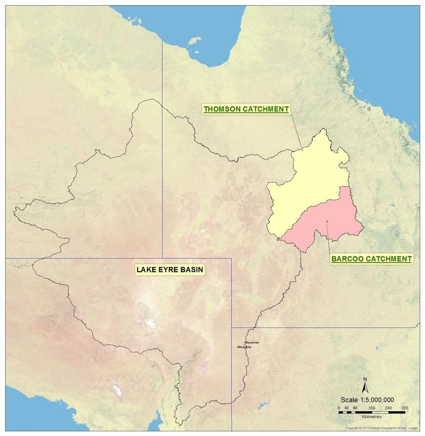
Draft environmental values for the waterways of the
Thomson and Barcoo catchments, Queensland
Groundwater exists in the Cooper catchment in limited volumes from shallow unconfined and semi-
confined aquifers, however the greatest volumes and most reliable supply comes from within the
deeper confined strata of the Great Artesian Basin (GAB). The GAB is a hydrogeological basin that
underlies most of the Lake Eyre Basin and is the world’s largest artesian groundwater basin. The GAB
includes geological basins such as the Eromanga and Galilee Basins which have strata of variable
geological ages from the relatively young Jurassic-Cretaceous sediments to the much older Permian-
Triassic aged sediments. The most important water bearing formations are the Hooray and Hutton
super groups which supply the majority of stock and domestic water in western Queensland. In the
Galilee Basin these formations overlie the Betts Creek Beds and Aramac Coal Measures which are
the target formations for Coal Seam Gas throughout the Galilee Basin and coal mining on the eastern
margins where these formations rise towards the surface. Shale gas occurs in carbon rich
formations. Target formations are generally deep and geologically old however some exploratory
work has been occurring targeting the Allaru Mudstones. Shale Gas development is expected in the
Cooper Basin.
In the absence of permanent surface water resources, the GAB provides most of the stock and
domestic water supply in the Lake Eyre Basin. Shallow aquifers are recharged locally during rain
events through creek flow and direct infiltration into the ground, whereas the GAB is recharged from
infiltration where the sandstone outcrops along the eastern margin of the basin, on the north-west
slopes of the Great Dividing Range.
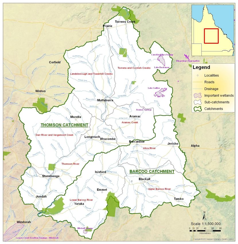
The Thomson and Barcoo catchments
The Thomson and Barcoo Rivers form the headwaters of the Cooper Creek catchment (refer to
Figure 1).
Figure 1. The Thomson and Barcoo catchments
5
July 2013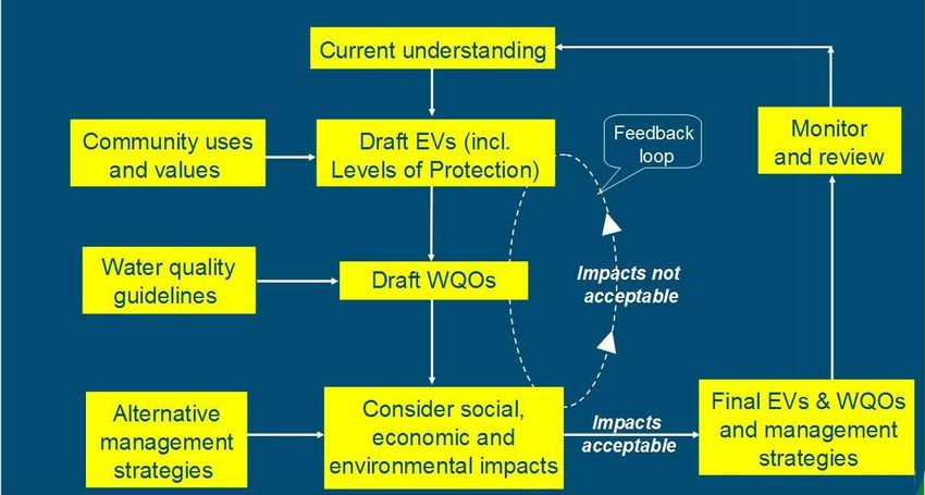
Draft environmental values for the waterways of the
Thomson and Barcoo catchments, Queensland
The northern headwaters of the Thomson River begin as Torrens Creek near Hughenden. The
Towerhill, Landsborough, Cornish Creeks join Torrens Creek just north of Muttaburra to form the
Thomson River. Aramac Creek joins the Thomson from the east, between Muttaburra and
Longreach, and the Darr River and Vergemont Creek flow from the west, joining the Thomson
between Longreach and Stonehenge. It continues in a south-westerly direction and joins the Barcoo
River between Jundah and Windorah to form Cooper Creek.
The Barcoo River starts just east of Tambo and flows in a north-westerly direction through Tambo.
Major tributaries are the Windeyer and Birkhead Creek, which head on the western slopes of the
Great Dividing Range. Ravensbourne Creek heads in the Gowan Ranges and meets the Barcoo west
of Blackall. The Alice River flows south from its headwaters near Jericho and flows into the Barcoo
north-west of Blackall. After this junction the Barcoo turns south and generally follows a south-
westerly course. Powell Creek heads in the Grey Range and flows into the Barcoo east of Jundah. The
Barcoo joins the Thomson River between Jundah and Windorah to form Cooper Creek.
Legislative context
The principal legislative basis for water quality management in Queensland is the Environmental
Protection (Water) Policy 2009 (EPP Water), which embodies the principles of the National Water
Quality Management Strategy. The EPP Water includes a process for:
Identifying environmental values of waterways, including both aquatic ecosystem values,
and human use values. (The range of environmental values that may apply to waterways is
summarised in Table 1); and
Establishing corresponding water quality objectives (also known as targets) to protect
identified environmental values. Water quality objectives are established for different
indicators of water quality such as pH, nutrients and toxicants.
For the protection of environmental values, the EPP Water lists a range of characterisations of water
based on the biological integrity of the aquatic ecosystems. The highest protection level addressed
in this report is for high ecological value waters - waters where the biological integrity of an aquatic
ecosystem is effectively unmodified or highly valued. The management intent specified in the EPP
Water for different categories guides decisions that may affect the waters (i.e. release of waste
water or contaminant) and states that, for high ecological values waters, the measures for the
indicators for all environmental values are maintained.
Achieving the identified water quality objectives for a waterway means the corresponding
environmental values and uses of that waterway will be protected. Where environmental values and
water quality objectives are included in the policy (Schedule 1 of the EPP Water), these take
precedence over the values in the Queensland Water Quality Guidelines when making decisions
under the EPP Water.
Note that environmental values and water quality objectives for a number of regions have been
scheduled under the EPP Water, with the Queensland Water Quality Guidelines acting as a primary
technical input. These can be accessed via: http://www.ehp.qld.gov.au/water/policy/
Local water quality guidelines
Technical water quality guidelines - such as the Queensland Water Quality Guidelines (DERM 2009b)
and Australian and New Zealand Guidelines for Fresh and Marine Water Quality (ANZECC and
ARMCANZ 2000) - form important input to this environmental values/water quality objectives
process because they can be used as a starting point in setting local water quality objectives. They
also act as default water quality objectives in the absence of any scheduled environmental
6
July 2013
Draft environmental values for the waterways of the
Thomson and Barcoo catchments, Queensland
values/water quality objectives. Because the environmental values/water quality objectives process
requires stakeholder input and the consideration of social/economic impacts, the adopted
environmental values and water quality objectives may differ from guideline values contained in the
technical water quality guidelines.
Progress to date
The regional natural resource management group Desert Channels Queensland has been
commissioned by the Department of Environment and Heritage Protection to capture the
community’s uses and values for water in the Thomson and Barcoo River catchments and develop
draft environmental values for 8 subcatchments within these catchments. This report summarises
the outcomes of the work to date, including:
Establishment of draft environmental values in consultation with stakeholder groups
Identification of areas of high environmental values for establishment of protection levels
Preparation of this report for public consultation on the draft environmental values
Figure 2 Process to set environmental values and water quality guidelines
What’s next?
When the community’s feedback on this report has been received, it will be incorporated into a
revised set of draft environmental values and a consultation report for provision to the Department
of Environment and Heritage Protection for consideration for scheduling in the EPP Water.
Environmental values
Environmental values and water quality objectives have been set for many of Queensland’s
waterways, including Moreton Bay/South East Queensland, the Mary River Basin/Great Sandy
Region, the Wet Tropics (north) and Trinity Inlet, and the Fitzroy Basin. The environmental values
and water quality objectives for these areas are documented in Schedule 1 of the EPP Water and in
the Queensland Water Quality Guidelines 2009 (DEHP 2013)
Environmental values and water quality objectives are developed to provide locally relevant
guidelines as benchmarks for the assessment and protection of local water quality. This provides the
7
July 2013Draft environmental values for the waterways of the
Thomson and Barcoo catchments, Queensland
framework under which a Healthy Waters Management Plan can be developed to assist the
community to achieve its water quality objectives over time. The Plan guides the development
approvals process to ensure that new developments protect the environmental values and water
quality objectives set by the community and recognised through government scheduling.
The list of environmental values (DEHP 2013) and the symbols used for them are outlined in Table 1
Table 1. Environmental values list, icons and definition
Drinking Water Raw drinking water supplies
Stock watering Livestock drinking water
Direct contact with water, such as swimming or
Primary recreation
waterskiing
Indirect contact with water, such as fishing,
Secondary recreation
boating/canoeing or sailing
Visual appreciation without contact with water, such
Visual appreciation
as picnicking, bushwalking or sightseeing
Current
uses Human consumption of wild or stocked fish or
Human consumption
crustaceans, such as yabbies
Aquaculture Commercial aquaculture ventures
Irrigation of crops, pastures, parks, gardens,
Irrigation
recreational areas
Farm use Farm use for laundry, wash down areas, fruit packing
Industrial use such as power generation,
Industrial use manufacturing plants. Industries usually treat water
supplies to meet their needs
The value of aquatic ecosystems. An aquatic
ecosystem is defined as a community of organisms
Aquatic ecosystems
living within or adjacent to water, including riparian
areas.
Values
The aesthetic, historical, scientific, social or other
Cultural and spiritual
significance to the present generation or past or
values
future generations
8
July 2013Draft environmental values for the waterways of the
Thomson and Barcoo catchments, Queensland
Draft environmental values
The process
Stakeholders were invited to complete a survey to identify the uses of surface water and
groundwater in the Thomson and Barcoo catchments and the ecological and cultural or spiritual
values the waterways have. Surface water was taken to include rivers, creeks, waterholes, swamps
and wetlands. Groundwater was taken to include borewater and springs. Respondents were asked
to nominate the rivers or creeks and/or the location of the groundwater that they wanted to
comment on. The link to a digital survey (click here for digital survey) was sent to people on the
Desert Channels Queensland contacts database and a hardcopy (Appendix 1) was sent in a mailout
to every ratepayer in the Thomson and Barcoo catchment area (approximately 4,000 ratepayers).
Fifty responses were received.
The responses for individual waterways were then grouped into sub-catchments. Previous division of
the catchments into subcatchments for work undertaken through the State of the Rivers project
(Moller 2000) has been adopted for this process. These subcatchments are shown in Figure 3.
Figure 3. Subcatchment boundaries for environmental values setting in the Thomson and Barcoo
catchments
9
July 2013Draft environmental values for the waterways of the
Thomson and Barcoo catchments, Queensland
Detailed responses about the natural assets and ecological values, and the cultural and spiritual
values (Indigenous and other) are included in Appendix 2.
One community workshops was then held in each of the 2 catchments. The meeting for the Barcoo
catchment was held in Blackall on 29th April 2013, while the meeting for the Thomson catchment
was held in Longreach on 30th April 2013. Four landholders attended the Blackall meeting and one
landholder attended the Longreach meeting. Two Department of Environment and Heritage
personnel from the Water Quality section attended the meetings to outline the Environmental
Values development process and introduce the concept of High Ecological Value areas. Attendees
helped to identify the human uses for each sub-catchment.
Assignment of environmental values to subcatchments of the Thomson and Barcoo
catchments
Surface water
A summary of the subcatchments and their associated draft environmental values for surface waters
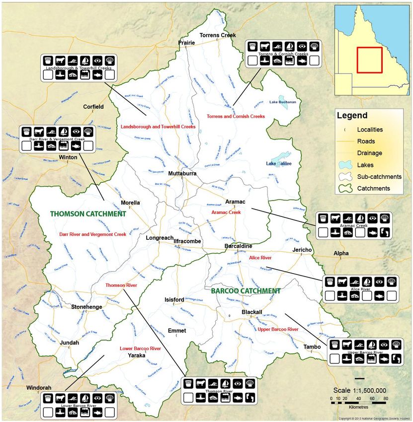
are depicted in Table 2 and Figure 4.
Table 2. Draft environmental values and uses for the surface waters of the Thomson and Barcoo
rivers catchments
Draft surface water environmental values and uses
Catch- Sub-
ment catchment
Torrens &
Cornish Creeks
Landsborough &
Towerhill
Thomson River
Catchment
Creeks
Aramac Creek
Thomson River
Darr River &
Vergemont
Creek
Upper Barcoo
Barcoo River
Catchment
River
Alice River
Lower Barcoo
River
10
July 2013Draft environmental values for the waterways of the
Thomson and Barcoo catchments, Queensland
Figure 4. Draft environmental values and uses for the surface waters of the Thomson and Barcoo
catchments
11
July 2013Draft environmental values for the waterways of the
Thomson and Barcoo catchments, Queensland
Table 3 contains detailed descriptions surrounding the identification of the environmental values for
surface water attached to each sub-catchment.
Table 3. Description of environmental values/uses of the surface waters of the Thomson and
Barcoo rivers catchments
Draft surface water values/uses descriptions
Catchment Subcatchment Value/Use Description
Drinking water Kitchen and bathroom use
Stock watering Grazing use
Primary recreation Swimming and waterskiing at Lake Dunn
Secondary recreation Fishing, yabbying
Picnicking, camping, bushwalking,
sightseeing at White Mountains, Moorrinya
Visual appreciation and Forest Den National Parks; Lakes Dunn,
Galilee and Buchanan; Cornish Creek rest
Torrens & Cornish area
Creeks Human consumption Fish and yabbies
Irrigation Homestead gardens
Farm use Laundry
Industrial use Roadworks
Permanent waterholes; Lakes Buchanan
and Galilee, and Cauckingburra Swamp –
Aquatic ecosystem listed in Directory of Important Wetlands;
White Mountains, Moorrinya and Forest
Den National Parks
Drinking water Kitchen and bathroom use
Thomson Stock watering Grazing use
River Primary recreation Swimming
Secondary recreation Fishing, yabbying
Landsborough & Picnicking, camping, bushwalking,
Visual appreciation
Towerhill Creeks sightseeing, Kooroorinya Falls
Human consumption Fish and yabbies
Irrigation Homestead gardens
Farm use Laundry use
Aquatic ecosystem Permanent waterholes
Drinking water Kitchen and bathroom use
Stock watering Grazing use
Primary recreation Swimming
Secondary recreation Fishing and yabbying
Visual appreciation Sightseeing, picnicking
Aramac Creek Human consumption Fish and yabbies
Irrigation Homestead gardens
Farm use Laundry use on properties
Aquatic ecosystem Permanent waterholes
Cultural and spiritual Known Aboriginal and European cultural
values sites
12
July 2013Draft environmental values for the waterways of the
Thomson and Barcoo catchments, Queensland
Draft surface water values/uses descriptions
Catchment Subcatchment Value/Use Description
Town water supply for Ilfracombe,
Drinking water Longreach, Stonehenge and Jundah;
kitchen and bathroom use on properties
Stock watering Grazing use
Primary recreation Swimming, waterskiing
Secondary recreation Fishing, yabbying, boating/canoeing
Picnicking/camping, sightseeing,
Visual appreciation bushwalking, tourism; Lochern National
Park
Thomson River
Human consumption Fish and yabbies
Extraction licences, town parks and
Irrigation
gardens, homestead gardens
Farm use Laundry use
Thomson
Industrial use Road construction, vehicle wash-down
River
Permanent waterholes, Lochern National
Aquatic ecosystem
Park
Known Aboriginal and European cultural
Cultural/spiritual values
sites
Drinking water Kitchen and bathroom use
Stock watering Grazing use
Primary recreation Swimming
Secondary recreation Fishing, yabbying
Darr River &
Visual appreciation Picnicking/camping
Vergemont Creek
Human consumption Fish and yabbies
Irrigation Homestead gardens
Farm Use Laundry use
Aquatic ecosystem Permanent waterholes
Drinking water Kitchen and bathroom use
Stock watering Grazing use
Primary recreation Swimming, waterskiing in Tambo Dam
Secondary recreation Fishing
Tambo Dam recreational area;
Visual appreciation picnicking/camping, sightseeing, tourism
Barcoo Upper Barcoo along Barcoo River
River River Human consumption Fish and yabbies
Irrigation Homestead gardens
Farm use Laundry use
Industrial use Road construction, vehicle wash-down
Aquatic ecosystem Permanent waterholes
Known Aboriginal and European cultural
Cultural/spiritual values
sites, Chinese gardens
13
July 2013Draft environmental values for the waterways of the
Thomson and Barcoo catchments, Queensland
Draft surface water values/uses descriptions
Catchment Subcatchment Value/Use Description
Drinking water Kitchen and bathroom use
Stock watering Grazing use
Primary recreation Swimming
Secondary recreation Fishing and yabbying
Picnicking/camping, sightseeing, tourism,
Alice River Visual appreciation
Lloyd Jones Weir
Human consumption Fish and yabbies
Irrigation Homestead gardens
Farm use Laundry use
Aquatic ecosystem Permanent waterholes
Barcoo
River
Town water supply for Isisford; kitchen and
Drinking water
bathroom use
Stock watering Grazing use
Primary recreation Swimming
Secondary recreation Fishing, boating/canoeing
Lower Barcoo
Visual appreciation Welford & Hell Hole Gorge National Parks
River
Human consumption Fish and yabbies
Irrigation Homestead gardens
Farm use Laundry use
Permanent waterholes; Welford & Hell
Aquatic ecosystem
Hole Gorge National Parks
14
July 2013Draft environmental values for the waterways of the
Thomson and Barcoo catchments, Queensland
Groundwater
A summary of the subcatchments and their associated draft environmental values for groundwaters
are depicted in Table 4 and Figure 5.
At this stage environmental values for groundwater have only been identified according to their
position in the surface water catchments. While the positions of shallow alluvial aquifers correspond
with surface water catchments, the positions of the deeper confined aquifers of the Great Artesian
Basin (GAB), do not correspond with single surface water catchments due to their massive lateral
extent. Spring groups from GAB aquifers can be located within a catchment however this could
misrepresent the recharge source and the impact of surface works on the yield from these
formations. As the water quality from each formation varies, the incorporation of the groundwater
will need to identify the different aquifers and their particular environmental values. E.g. some
aquifers are suitable for stock drinking water while others aren’t.
Table 4. Draft environmental values and uses of the groundwaters of the Thomson and Barcoo
catchments
Draft groundwater environmental values and uses
Catch- Sub-
ment catchment
Torrens &
Cornish Creeks
Thomson River Catchment
Landsborough &
Towerhill
Creeks
Aramac Creek
Thomson River
Darr River &
Vergemont
Creek
Upper Barcoo
Barcoo River
Catchment
River
Alice River
Lower Barcoo
River
15
July 2013Draft environmental values for the waterways of the
Thomson and Barcoo catchments, Queensland
Figure 5. Draft Environmental Values for the groundwaters of the Thomson and Barcoo
catchments
16
July 2013Draft environmental values for the waterways of the
Thomson and Barcoo catchments, Queensland
Table 5 contains detailed descriptions surrounding the identification of the environmental values for
groundwaters attached to each sub-catchment.
Table 5. Description of Environmental Values of the Groundwater of the Thomson and Barcoo
Rivers Catchments
Draft groundwater values/uses descriptions
Catchment Subcatchment Value Description
Town water supply for Torrens Creek;
Drinking water
kitchen and bathroom use
Stock watering Grazing
Torrens & Cornish Secondary recreation Yabbying in bore drains
Creeks Human consumption Yabbies from bore drains
Irrigation Parks and gardens
Farm use Laundry use
Aquatic ecosystem Groundwater springs
Drinking water Kitchen and bathroom use
Stock watering Grazing
Primary recreation Swimming
Landsborough &
Secondary recreation Yabbying in bore drains
Towerhill Creeks
Human consumption Yabbies from bore drains
Farm use Laundry use
Aquatic ecosystem Groundwater springs
Town water supply for Aramac; kitchen
Drinking water
and bathroom use
Thomson Stock watering Grazing
River Secondary recreation Yabbying in bore drains
Human consumption Yabbies from bore drains
Aramac Creek
Irrigation Town water supply for Aramac
Farm use Laundry use
Industrial Coal seam gas pilot wells
Groundwater springs, endangered
Aquatic ecosystem
species, Edgbaston Nature Reserve
Town water supply for Muttaburra and
Drinking water
Ilfracombe; kitchen and bathroom use
Stock watering Grazing
Primary recreation Artesian spa/bath at Ilfracombe
Secondary recreation Yabbying in bore drains
Thomson River Human consumption Yabbies from bore drains
Irrigation Homestead gardens
Farm use Laundry use on properties
Aquatic ecosystem Groundwater springs
Known Aboriginal cultural sites at
Cultural/spiritual values
springs
17
July 2013Draft environmental values for the waterways of the
Thomson and Barcoo catchments, Queensland
Draft groundwater values/uses descriptions
Catchment Subcatchment Value Description
Drinking water Kitchen and bathroom use
Stock watering Grazing
Primary recreation Homestead swimming pools
Thomson Darr River & Secondary recreation Yabbying in bore drains
River Vergemont Creek Human consumption Yabbies from bore drains
Aquatic ecosystem Groundwater springs
Known Aboriginal and European
Cultural/spiritual values
cultural sites at springs
Town water supply for Tambo and
Drinking water
Blackall
Stock watering Grazing
Artesian spa/bath at Blackall, Tambo
Primary recreation
Aquatic Centre
Secondary recreation Yabbying in bore drains
Upper Barcoo
Human consumption Yabbies from bore drains
River
Irrigation Blackall parks and gardens
Farm use Laundry use on properties
Industrial Vehicle wash down, saleyards
Aquatic ecosystem Groundwater springs
Known Aboriginal and European
Cultural/spiritual values
cultural sites at springs
Town water supply for Jericho and
Drinking water
Barcaldine; kitchen and bathroom use
Barcoo River Stock watering Grazing
Primary recreation Homestead swimming pools
Secondary recreation Yabbying in bore drains
Alice River
Human consumption Yabbies from bore drains
Irrigation Barcaldine parks and gardens
Farm use Laundry use on properties
Industrial Road construction, vehicle wash-down
Aquatic ecosystem Groundwater springs
Drinking water Kitchen and bathroom use
Stock watering Grazing
Primary recreation Homestead swimming pools
Lower Barcoo Secondary recreation Yabbying in bore drains
River Human consumption Yabbies from bore drains
Irrigation Homestead gardens
Farm use Laundry use on properties
Aquatic ecosystem Groundwater springs
18
July 2013Draft environmental values for the waterways of the
Thomson and Barcoo catchments, Queensland
Aquatic ecosystem protection levels
Protection levels are assigned to waters based on their associated values. For aquatic ecosystems,
the four protection levels prescribed in the EPP Water include:
High ecological value (HEV) waters - the biological integrity of an aquatic ecosystem that is
effectively unmodified or highly valued;
Slightly disturbed waters—the biological integrity of an aquatic ecosystem that has
effectively unmodified biological indicators, but slightly modified physical, chemical or other
indicator;
Moderately disturbed waters—the biological integrity of an aquatic ecosystem that is
adversely affected by human activity to a relatively small but measurable degree;
Highly disturbed waters—the biological integrity of an aquatic ecosystem that is measurably
degraded and of lower ecological value than waters mentioned in the levels above.
Protection levels for human use values are prescribed in the EPP Water, whereas aquatic ecosystems
can fall into any one of the categories listed above. National parks and some state forests are
determined to be areas of high ecological value. Wetlands included in the Directory of Important
Wetlands are also given the HEV classification.
Permanent waterbodies provide stability in systems that are characterised by aridity and variability,
such as the Lake Eyre Basin. They act as refuges during drought and underpin the health and viability
of aquatic ecosystems. From these refugia, wildlife can spread back out to other waterholes as water
returns to the system. Jenny Silcock (2009) has identified the permanent refuge waterbodies in the
Cooper Creek and these will be incorporated into the draft HEV areas of the Thomson and Barcoo
catchments.
The ecological and heritage value of springs have become increasingly recognised over the last few
decades, with various spring complexes being protected in National Park and Conservation Reserves.
In the Thomson catchment the Aramac spring complex has been protected by the purchase of
“Edgbaston” by Bush Heritage Australia. Bore capping through the Great Artesian Basin
Sustainability Initiative (GABSI) has resulted in a return of water pressure in bores and the recovery
of springs is being monitored.
Outcomes
A total of 12 areas containing waters of high ecological value have so far been identified across the
Thomson and Barcoo catchments (Table 6 and Figure 6). Waters falling within the other protection
levels will be identified.
19
July 2013Draft environmental values for the waterways of the
Thomson and Barcoo catchments, Queensland
Table 6. Draft HEV areas of the Thomson and Barcoo catchments
Catchment National Park Directory of Important Wetlands listing
White Mountains National Park Lake Buchanan
Moorrinya National Park Lake Galilee
Thomson
Forest Den National Park Cauckingburra Swamp
Lochern National Park Aramac Springs
Idalia National Park Mitchell Swamp
Barcoo Welford National Park
Hell Hole Gorge National Park
White Mountains
National
Park
Moorrinya
National
Park
Forest Den
National
Park
Lochern
National
Park
Idalia
National
Park
Welford
National
Park
Hell Hole Gorge
National
Park
Figure 6. Draft high ecological value areas in the Thomson and Barcoo Catchments
20
July 2013Draft environmental values for the waterways of the
Thomson and Barcoo catchments, Queensland
References
Chuk, M. & Kleinschmidt, M. 2004, Our Country; Our Community - a community information paper
for the Queensland section of the Lake Eyre Basin, Desert Channels Queensland, Longreach
DEHP 2013, What are EVs and WQOs Department of Environment and Heritage Management,
DEHP (2009) Queensland Water Quality Guidelines, Department of Environment and Heritage
Protection Version 3, 2013, ISBN 978-0-9806986-0-2.
Department of Sustainability, Environment, Water, Population and Communities, Directory of
Important Wetlands in Australia
Moller, G 2000, State of the Rivers Cooper Creek and Major Tributaries, Department of Natural
Resources, Brisbane
Silcock, J. 2009, Identification of Permanent Refuge Waterbodies in the Cooper Creek & Georgina-
Diamantina River Catchments for Queensland and South Australia. South Australian Arid Lands
Natural Resources Management Board.
21
July 2013Appendix 1. Survey mailed out to ratepayers of the Thomson and Barcoo catchments
How do you use and value the waterways of the
Thomson and Barcoo catchments?
Tell us what you love about your river and go in a draw to win
an iPad Mini!!
This project will identify ways to ensure the best management of our waterways in recognition of
the values and uses identified through mechanisms like this survey. Your contribution is important.
Waterways includes the surface water such as rivers, creeks, waterholes and swamps, and the
groundwater such as springs and bores.
Who can complete the survey?
Anyone who uses or values waterways in the Thomson & Barcoo River catchments is invited to
complete the survey. Refer to the attached map if you’re not sure if your waterway fits in.
If you’d like more information about this project and the survey open the Stakeholder Survey Information
attachment or contact Helen Cross (details below).
Completing the survey will take approximately 5 - 10 minutes for each waterway you wish to comment on.
Please submit your survey by Friday 19th April 2013.
There are 2 sections in this survey:
1. Surface Water, which includes rivers, creeks, lakes; waterholes and swamps; and
2. Groundwater, which includes springs and borewater.
Survey components
There are separate components to the survey. You are invited to fill in any or all of these parts:
Human Uses Ecological Values Cultural and Spiritual Values
Identifying locations of Seeking your input on natural Focussing on Indigenous and
recreation (swimming, fishing, assets in waterways (e.g. European cultural and spiritual
boating), primary industries habitat for key species) and values associated with
(irrigation, aquaculture etc those waterways you think are waterways
in the best condition
If you only wish to fill out one part, that is fine. We don’t expect you to be able to comment on all
the uses/values of all the waterways in the region. We are keen to receive any information you can
give us even if just for a single location.
If you would like to comment on more waterway locations than are provided for on this form, please
add more pages.
If you would like more information or assistance please contact Helen Cross at Desert Channels on
ph. 07 4652 7829, or email helen.cross@dcq.org.auSection 1. Surface waters of the Thomson and Barcoo catchments, such as the rivers,
creeks, waterholes, wetlands, etc.
1. What is the name of the creek or river you would like to comment on?
e.g. Vergemont Creek, Barcoo River
__________________________________
2. What is the nearest town to the above creek/river?
This will help us with the location of the waterway in case there are other creeks with the same
name, or to identify which section of the longer rivers you are referring to
__________________________________
3. Is there a specific part of the above creek/river you would like to comment on?
e.g. Boomerang Waterhole, Lily Lagoon, upstream of highway, near Longreach
__________________________________
4. Identify the uses that occur in that waterway
Unsur
Tick all that apply Yes Possibly No
e
Raw Drinking Water supplies
Stock watering
Primary recreation - direct contact with water occurs, such as swimming or
water skiing
Secondary recreation - indirect contact with water occurs, such as fishing,
boating, canoeing or sailing
Visual appreciation but no contact with water, such as picnicking,
bushwalking, sightseeing
Human Consumption of wild or stocked fish or crustaceans, such as yabbies
Water for Aquaculture from commercial ventures
Irrigation, e.g. crops or pastures, parks, gardens, recreational areas
Water for Farm use, e.g. laundry, fruit packing, wash down areas
Water for Industrial Use such as power generation, manufacturing plants.
Industries usually treat water to meet their needs
5. What natural assets or ecological values does this waterway contains?
e.g. unsure; it is largely unmodified or has undergone little change; it provides habitat for fish,
turtles, etc.; it has good riparian habitat; it is a refugia for endangered species.
_______________________________________________________________________________
_______________________________________________________________________________
_______________________________________________________________________________
_______________________________________________________________________________
_______________________________________________________________________________
6. What cultural or spiritual values does this waterway contains?
e.g. unsure, Indigenous or non-indigenous cultural heritage such as custodial, spiritual, cultural
or traditional heritage, hunting, gathering or ritual responsibilities; symbols, landmarks & icons
(waterways, turtles, frogs); lifestyles (agricultural, fishing)
_______________________________________________________________________________
_______________________________________________________________________________
_______________________________________________________________________________
23
July 2013Section 2.1 Groundwater of the Thomson and Barcoo catchments –Springs
1 What is the name of the spring/spring group you would like to comment on?
e.g. Edgbaston complex, Barcaldine super group, unsure, un-named
___________________________________________________________________________
2 What is the location of the spring/s?
Give GPS coordinates if possible, or state the name of the property and/or describe the location
___________________________________________________________________________
3. Identify the uses that occur at the springs
Unsur
Tick all that apply Yes Possibly No
e
Raw Drinking Water supplies
Stock watering
Primary recreation - direct contact with water occurs, such as swimming or
water skiing
Secondary recreation - indirect contact with water occurs, such as fishing,
boating, canoeing or sailing
Visual appreciation but no contact with water, such as picnicking,
bushwalking, sightseeing
Human Consumption of wild or stocked fish or crustaceans, such as yabbies
Water for Aquaculture from commercial ventures
Irrigation, e.g. crops or pastures, parks, gardens, recreational areas
Water for Farm use, e.g. laundry, fruit packing, wash down areas
Water for Industrial Use such as power generation, manufacturing plants.
Industries usually treat water to meet their needs
7. What natural assets or ecological values does this spring contain?
e.g. unsure; it is largely unmodified or has undergone little change; it provides habitat for fish,
turtles, etc.; it has good riparian habitat; it is a refugia for endangered species.
_______________________________________________________________________________
_______________________________________________________________________________
_______________________________________________________________________________
_______________________________________________________________________________
_______________________________________________________________________________
8. What cultural or spiritual values does this spring contain?
e.g. unsure, Indigenous or non-indigenous cultural heritage such as custodial, spiritual, cultural
or traditional heritage, hunting, gathering or ritual responsibilities; symbols, landmarks & icons
(waterways, turtles, frogs); lifestyles (agricultural, fishing)
_______________________________________________________________________________
_______________________________________________________________________________
_______________________________________________________________________________
_______________________________________________________________________________
_______________________________________________________________________________
24
July 2013Section 2.2 Groundwater of the Thomson and Barcoo catchments –Borewater
1. What is the location of the borewater you would like to comment on?
e.g. property name, name of town, general location
___________________________________________________________________________
2. IDENTIFY THE USES that occur at the location of the borewater
Unsur
Tick all that apply Yes Possibly No
e
Raw Drinking Water supplies
Stock watering
Primary recreation - direct contact with water occurs, such as swimming or
water skiing
Secondary recreation - indirect contact with water occurs, such as fishing,
boating, canoeing or sailing
Visual appreciation but no contact with water, such as picnicking,
bushwalking, sightseeing
Human Consumption of wild or stocked fish or crustaceans, such as yabbies
Water for Aquaculture from commercial ventures
Irrigation, e.g. crops or pastures, parks, gardens, recreational areas
Water for Farm use, e.g. laundry, fruit packing, wash down areas
Water for Industrial Use such as power generation, manufacturing plants.
Industries usually treat water to meet their needs
3. What natural assets or ecological values does this borewater contain?
e.g. unsure; it provides habitat for fish, waterbirds, etc.
___________________________________________________________________________
25
July 2013Are there any other comments you would like to make?
__________________________________________________________________________________
__________________________________________________________________________________
__________________________________________________________________________________
__________________________________________________________________________________
__________________________________________________________________________________
__________________________________________________________________________________
__________________________________________________________________________________
__________________________________________________________________________________
__________________________________________________________________________________
Personal information
Your contact details will be helpful if we need to clarify the location of a waterbody. Your name and
contact details will also be entered in the prize draw to win an iPad Mini. One entry per person.
Name: ___________________________________________________________________________
Organisation, interest group, or land use: _______________________________________________
Email address: _____________________________________________________________________
Contact phone: ____________________________________________________________________
Would you like to be informed of Desert Channels updates? Yes No
The study team will hold meetings in Blackall from 1-3pm on Monday 29th April and in Longreach
from 9-11am on Tuesday 30th April. Are you interested in attending a stakeholder meeting to
provide further information on waterway uses and values? Yes No
Fax your completed survey to Desert Channels on 4658 0122
Or scan it in and email it to helen.cross@dcq.org.au
26
July 2013Appendix 2. Survey responses regarding the natural assets and ecological values
and the cultural and spiritual values of the waterways of the Thomson and Barcoo
catchments
As well as identifying the human uses of the waterways of the Thomson and Barcoo Catchments
respondents to the survey were asked for their input on the natural assets and ecological values, and
the cultural and spiritual values (Indigenous and other) of the waterways. The questions (and
examples) were as follows:
Q. What natural assets or ecological values does this waterway contains?
e.g. unsure; it is largely unmodified or has undergone little change; it provides habitat for
fish, turtles, etc.; it has good riparian habitat; it is a refugia for endangered species.
Q. What cultural or spiritual values does this waterway contains?
e.g. unsure, Indigenous or non-indigenous cultural heritage such as custodial, spiritual,
cultural or traditional heritage, hunting, gathering or ritual responsibilities; symbols,
landmarks & icons (waterways, turtles, frogs); lifestyles (agricultural, fishing)
The following are the responses grouped by subcatchment:
Torrens & Cornish Creeks
Natural assets and ecological values
Surface water – no responses
Borewater – no responses
Springs
Great monitoring sites for the Artesian Basin, should be a baseline testing regime
established to monitor what is occurring in the GAB. Unmodified.
Cultural & spiritual values
Surface water – no responses
Borewater – no responses
Springs
Important to indigenous for survival and cultural reasons- should be respected by all people.
my comments apply to all mound springs throughout the LEB, we need to look after them all
Landsborough & Towerhill Creeks
Natural assets and ecological values
Surface water
It has undergone little change while providing habitats for native fauna, it is largely
unmodified or has undergone little change; it provides habitat for fish, turtles, etc.; it has
good riparian habitat; it is a refugia for endangered species.
Surface water for roos etc, slows the water for grasslands and trees surrounding creek,
breeding ground for many frogs and fish and crabs, feeds into the larger creeks to join the
Thomson river.
Borewater
Township water, provides habitat for local flora & fauna
It contains very alkaline minerals and salts that help maintain us and has natural occurring
fluoride. It is free from introduced chemicals and mud/dirt. It is very slippery to the touch
"old" water as it is known, a water that has been filtered for many years down in the earth
to be purified. Without this water most of the animal life we see on the place wouldn’t be
here, it couldn’t possibly exist. Once the bore water is brought to the surface many natural
birds and kangaroos live at it and it maintains a frog population.
27
July 2013Springs - no responses
Cultural & spiritual values
Surface water
It draws energy from the wider land and narrows it into the big river of the Thomson. I
believe any of the creeks are a place of refugee from the heat and vastness of the land
around it.
Borewater – no responses
Springs - no responses
Aramac Creek
Natural assets and ecological values
Surface water
All of the above (examples after question).
Borewater
Limited habitat for very small fish in boredrains but is a habitat for birds although the bore
only supplies less than 10kms of drain which is due to be replaced in the current year.
Springs – no responses
Cultural & spiritual values
Surface water
Lower Aramac Creek has nearby remains of Scarbury village cattle yards and well maintained
grave of young boy from 1870's
Borewater - no responses
Springs - no responses
Thomson River
Natural assets and ecological values
Surface water
It has undergone little change while providing habitats for native fauna, it is largely
unmodified or has undergone little change; it provides habitat for fish, turtles, etc.; it has
good riparian habitat; it is a refugia for endangered species,
It is in pristine condition after centuries of good custodian treatment, it provides habitat for
a huge range of plant and animal life and is a refuge for many endangered species.
Habitat for a variety of species: e.g., fish, waterbirds, hollow-nesting species; Refugia area;
Flood mitigation;
The stretch of the river at Longreach between the weirs provides a year round body of water
that enables healthy populations of aquatic species to survive and multiply. There are some
non endemic species (redclaw, invasive weeds) that are currently affecting the waterway
and should be managed.
Virtually unblemished, riparian areas in good condition, good interaction between all users-
environmental, eco and human. Good tourist spots largely respected by all
All elements essential to life ( and a few not so essential and unpleasant) used for
stockwater - a very vital piece of infrastructure for stock use. Source needs protection
It is largely unmodified or has undergone little change; it provides habitat for fish, turtles,
Unmodified waterhole and provides a habitat for all water creatures found in our western
rivers from our fish species through to turtles and smaller freshwater crustaceans. Our
native wildlife also depend on the healthy river system
Provides water for our stock to drink
It is largely unmodified and undergone little change, which is mainly due to the fact that we
the landholders monitor our waterways to keep then in the condition that they are in today.
28
July 2013It is a very fragile and sensitive environment that needs to be looked after by the people
that rely on the river for their likelihoods and recreation, to maintain the habitats of plants
and animals that coexist with the river and maintain this natural asset for future
generations.
This section of the river appears wide and to be deep (near Longreach). I would imagine it
contains habitat for fish, turtles, yabbies and supports a range of other animals and birds
Largely unmodified except for man-made weirs to hold extra body of water.
Habitat for fish, yabbies, turtles, etc.
Provides habitat for fish, yabbies, turtles
Natural, unchanged
Fish, redclaw
Undergone little change due to past generations caring for the system
It provides life to the region & its industry, stock & humans - water is a very precious
resource
Has undergone little change at Stonehenge, provides habitat for fish, yabbies.
Borewater
It provides habitat for plants and animals
It provides a water source not only for domestic use but watering points for our wildlife,
especially birds
It provides habitat for all bird life, and native animals also for watering stock (cattle)
Provides extended water for natural animals e.g. Kangaroos and birds
Ready supply of hot borewater (Why did the Council disconnect the borewater?)
Saving river water for gardens, etc.
Springs - no responses
Cultural & spiritual values
Surface water
Our total way of life with a strong regard for our cultural heritage
Recreational and aesthetic values for community;
There is significant non indigenous history on this section of the river due to its importance
to the establishment of Longreach as a rural community.
Different things to different cultures but something to be revered, used but not abused
Recreation activities such as fishing, swimming and kayaking all play a part in the lives of the
residents of Jundah and surrounding districts.
I’m a white fella
Lifestyle
Camping, fishing, cruising on boats (skiing) and tours, etc.
My family settled on these rivers. I am 5th generation
Water - we pray for it, we respect it, we need to use it & we thank God for it
Unsure, no indigenous persons in area that I am aware of (Stonehenge)
Borewater - no responses
Springs - no responses
29
July 2013Darr River & Vergemont Creek
Natural assets and ecological values
Surface water
Largely unmodified, the Vergemont provides essential beneficial flooding for riparian
pastoral properties, without this flooding, these properties become unviable.
Undisturbed and provides a habitat for native animals as well as a source of water for
domestic stock.
One of the best tributaries of the Thomson (Katherine Creek). A good riparian habitat
Habitat for native species, vegetation cover for bird nesting
Borewater
It is a back up source of water for primary production
Springs – no responses
Cultural & spiritual values
Surface water
Historical society has investigated possible explorer markings and spear markings on trees.
Hey, we are indigenous too, and this area is important to us.
Hunting and gathering area for population in the past (Tocal Creek)
Borewater - no responses
Springs - no responses
Upper Barcoo River
Natural assets and ecological values
Surface water
Permanent waterhole (junction of Alice & Barcoo)
It provides habitat for a number of animals
Habitat for water, tree & land life
This portion of the river has undergone little or no change within my 60 years association
with this waterway except for the introduction of carp & the lack of control of burrs since
the wool industry demise.
Beautiful spot for enjoying many animal species e.g. koalas, possum, quoll, bird watching
It is largely unmodified and has undergone little change; it provides habitat for fish, turtles,
etc.; it has good riparian habitat; it is a refugia for endangered species, and stock water
supply
Borewater
Adds to river environment. Secondary water process & used for irrigation
The ecological is the naturally occurring fluoride & if you live close enough to the bore head -
hot water
This groundwater is part of the Great Artesian Basin (GAB), which provides water for
numerous towns, and stock water for a significant portion of the livestock within the area of
the Barcoo/Thomson catchment. Without the GAB the pastoral industry could not exist
within the catchment. The future of the GAB is under threat from resource industries,
particularly from Coal Seam Gas. Any threat to the GAB is a threat to the pastoral industry
and to the people involved in managing and servicing it. It is up to all of us to ensure that
that threat never materializes.
Springs – no responses
30
July 2013Cultural & spiritual values
Surface water
The waterhole is an icon/landmark (junction of Alice & Barcoo)
For the indigenous community it was of vital importance. As I am not indigenous it is not
appropriate that I comment
Social gathering has been held to present visual art depicting Aboriginal history of local
tribes (being meeting place in past for several tribes)
Nil, "Aboriginal Industry" nonsense
Borewater - no responses
Springs - no responses
Alice River
Natural assets and ecological values
Surface water
An enormous amount. This is the headwaters of the Cooper Creek and is in the Desert
Uplands which remains 70% uncleared woodlands with mostly native grasses, so the natural
assets are many, which is easily referenced in many scientific papers, hence I do not need to
list here
Permanent waterhole (junction of Alice & Barcoo)
Habitat for fish and lobbies
A refugia for endangered species & wildlife. Unfortunately it has a cactus infestation & lots
of dingoes use it as a corridor (Lagoon Creek)
it is largely unmodified or has undergone little change; it provides habitat for fish, turtles,
etc.; it has good riparian habitat; it is a refugia for endangered species.
Borewater
It sustains the beef enterprises and the community!!!!!!!!!!! Remember it is the troughs and
poly infrastructure that is maintaining a lot of bird and marsupials through the dry’s
Habitat for yabbies, birdlife, diversity in our landscape
For human consumption and stock watering
Springs - no responses
Cultural & spiritual values
Surface water
No indigenous activity and may have Title claim
Borewater - no responses
Springs - no responses
Lower Barcoo River
Natural assets and ecological values
Surface water
Undergone little change
It provides life to the region & its industry, stock & humans - water is a very precious
resource
One of the best natural rivers in QLD and will be destroyed if irrigation or commercial that
will produce salt and destroy the run of the river.
Largely unmodified, good riparian habitat & habitat for fish, etc
No change in the twenty years of our connection with this waterhole. Fish & turtles inhabit
this waterhole but no fishing occurs. Native animals and cattle water here
31
July 2013You can also read