AQUATIC SPECIALIST ASSESSMENT FOR THE PROPOSED REMEDIAL WORKS AT BON AMIS DAM ON THE FARM BLOEMENDAL IN DURBANVILLE - Doug Jeffery Environmental ...
←
→
Page content transcription
If your browser does not render page correctly, please read the page content below
AQUATIC SPECIALIST ASSESSMENT FOR THE PROPOSED
         REMEDIAL WORKS AT BON AMIS DAM ON THE FARM
                           BLOEMENDAL IN DURBANVILLE
                                   MARCH 2021

Prepared By:

Ms. Toni Belcher

Tel: 082 883 8055

Email: toni@bluescience.co.za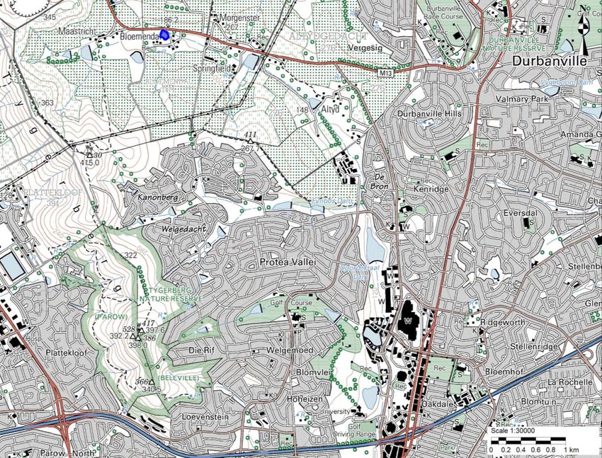
P a g e |2

TABLE OF CONTENTS

1.      SPECIALIST DETAILS, EXPERTISE AND DECLARATION .....................................................................................4

     1.1.        QUALIFICATIONS OF SPECIALIST CONSULTANT ........................................................................................................ 4
     1.2.        DECLARATION OF INDEPENDENCE ........................................................................................................................ 5

2.      INTRODUCTION AND DESCRIPTION OF STUDY ..............................................................................................6

     2.1.        BACKGROUND TO THE STUDY.............................................................................................................................. 6
     2.2.        TERMS OF REFERENCE ....................................................................................................................................... 7
     2.3.        METHODOLOGY ............................................................................................................................................... 7
     2.4.        USE OF THIS REPORT ........................................................................................................................................ 8

3.      DESCRIPTION OF THE PROPOSED ACTIVITY ...................................................................................................8

4.      GENERAL DESCRIPTION OF THE SURROUNDING CATCHMENT ..................................................................... 10

     4.1.        VISUAL CHARACTERISTICS ................................................................................................................................ 10
     4.2.        CLIMATE....................................................................................................................................................... 10
     4.3.        GEOLOGY AND SOIL ........................................................................................................................................ 11
     4.4.        FLORA .......................................................................................................................................................... 12
     4.5.        AQUATIC FEATURES ........................................................................................................................................ 13
     4.6.        LAND USE ..................................................................................................................................................... 15
     4.7.        CONSERVATION IMPORTANCE ........................................................................................................................... 15

5       RESULTS OF AQUATIC ECOSYSTEM ASSESSMENT ........................................................................................ 18

     5.1.        DESCRIPTION OF FRESHWATER FEATURES ASSESSED.............................................................................................. 18
     5.2         RIVER HEALTH ASSESSMENT ............................................................................................................................. 19
     5.3.        ECOLOGICAL IMPORTANCE AND SENSITIVITY ........................................................................................................ 20
     5.4.        RECOMMENDED ECOLOGICAL CONDITION OF AQUATIC FEATURES ........................................................................... 21

6.      AQUATIC IMPACT ASSESSMENT .................................................................................................................. 21

     6.1.        DESCRIPTION OF IMPACTS ................................................................................................................................ 21
     6.2.        CONSIDERATION OF ALTERNATIVES .................................................................................................................... 26

7.      RISK ASSESSMENT ....................................................................................................................................... 26

8.      CONCLUSIONS AND RECOMMENDATIONS .................................................................................................. 26

9.      REFERENCES ................................................................................................................................................ 29

APPENDIX 1: METHODOLOGIES USED IN THE ASSESSMENT ................................................................................. 31

     INDEX OF HABITAT INTEGRITY ........................................................................................................................................ 31
     ECOLOGICAL IMPORTANCE AND SENSITIVITY (EIS) ............................................................................................................. 32

APPENDIX 2: IMPACT ASSESSMENT METHODOLOGY ........................................................................................... 33

APPENDIX 3: RISK ASSESSMENT FOR ACTIVITIES UNDERTAKEN ........................................................................... 36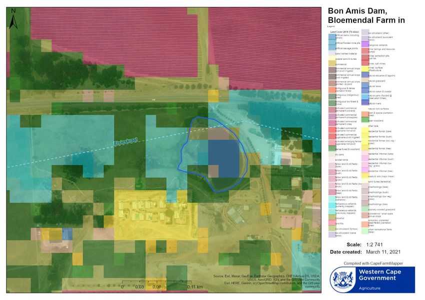
P a g e |3

LIST OF FIGURES
FIGURE 1. TOPOGRAPHICAL MAP INDICATING THE LOCATION OF BON AMIS DAM ........................................................................... 6
FIGURE 2: SPILLWAY DESIGN ................................................................................................................................................ 9
FIGURE 3: EARTH CHANNEL RESHAPING.................................................................................................................................. 9
FIGURE 4. VIEW OF THE SITE, LOOKING NORTHWARDS OVER THE BON AMIS DAM AND THE ELSIESKRAAL RIVER ................................. 10
FIGURE 5. AVERAGE RAINFALL (LEFT) AND TEMPERATURE (RIGHT) GRAPHS (CAPEFARMMAPPER, 2021) .......................................... 11
FIGURE 6. MONTHLY FLOW DISTRIBUTION CHART FOR THE ELSIESKRAAL RIVER BASED ON WR2012 MODELED FLOW DATA.................. 11
FIGURE 7. BROAD SOIL MAP OF THE STUDY AREA (CAPEFARMMAPPER, 2021) ............................................................................ 12
FIGURE 8. VEGETATION TYPES AT THE SITE AND SURROUNDING AREA (CAPEFARMMAPPER, 2021) ................................................. 13
FIGURE 9. GOOGLE EARTH IMAGE SHOWING THE MAPPED WATER FEATURES ON THE SITE .............................................................. 14
FIGURE 10. LANDCOVER MAP FOR THE SITE (CAPEFARMMAPPER, 2021) .................................................................................. 15
FIGURE 11. CITY OF CAPE TOWN SPATIAL BIODIVERSITY PLAN FOR THE SITE (SANBI BIODIVERSITY GIS, 2021) ................................ 16
FIGURE 12. FEPA RIVER MAPPING FOR THE SITE (SANBI BIODIVERSITY GIS, 2021) .................................................................... 17
FIGURE 13. FEPA WETLAND AND NATIONAL WETLAND MAP FOR THE SITE (CAPEFARMMAPPER, 2021) ........................................ 17
FIGURE 14. AN AERIAL PHOTOGRAPH TAKEN 1944 OVERLAIN IN GOOGLE EARTH WITH THE MAPPED AQUATIC FEATURES (BLUE
        LINE=WATERCOURSE AND BLUE POLYGONS=DAMS)........................................................................................................ 18
FIGURE 15. VIEW OF THE ELSIESKRAAL RIVER UPSTREAM OF BON AMIS DAM.............................................................................. 19
FIGURE 16. DIAGRAM INDICATING THE ALIGNMENT OF THE EXISTING CHANNEL (YELLOW DASHED LINE) AND THE PROPOSED NEW
        ALIGNMENT OF THE CHANNEL (BLACK DASHED LINE) ....................................................................................................... 22

LIST OF TABLES
TABLE 1: SUMMARY OF KEY WATER RESOURCE INFORMATION RELATED TO THE SITE ........................................................................ 7
TABLE 3. GEOMORPHOLOGICAL AND PHYSICAL FEATURES OF THE ELSIESKRAAL RIVER AT BON AMIS DAM......................................... 19
TABLE 4. INDEX OF HABITAT INTEGRITY ASSESSMENT FOR THE ELSIESKRAAL RIVER AT BLOEMENDAL AND D’ARIA............................... 20
TABLE 5. RESULTS OF THE EIS ASSESSMENT: ELSIESKRAAL RIVER .............................................................................................. 20
TABLE 6. A SUMMARY OF THE RISK ASSESSMENT FOR THE PROPOSED PIPELINES (SEE APPENDIX 3 FOR FULL RISK MATRIX) ................... 26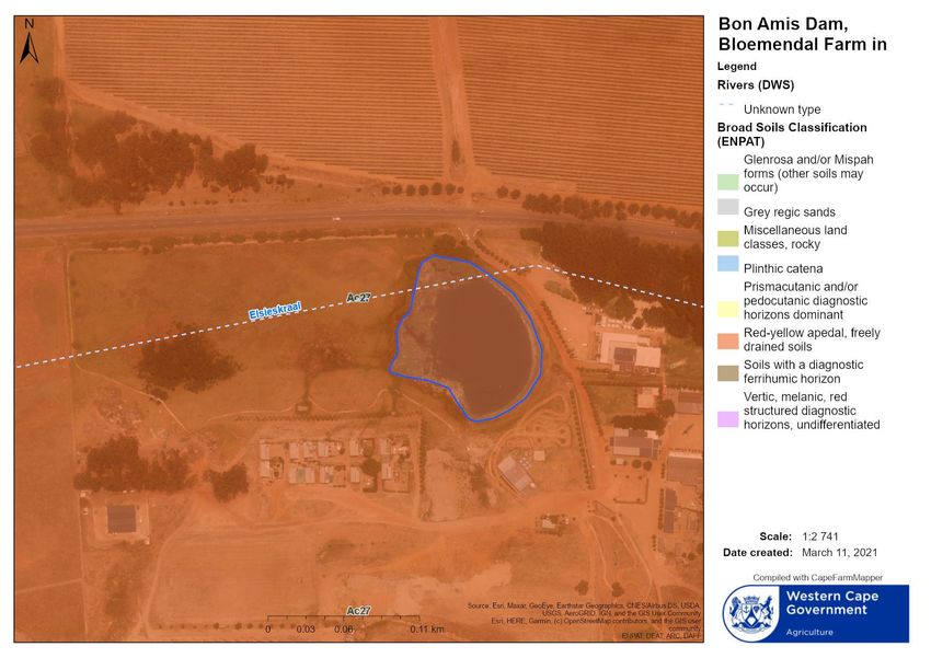
P a g e |4

1.       SPECIALIST DETAILS, EXPERTISE AND DECLARATION

1.1.     QUALIFICATIONS OF SPECIALIST CONSULTANT

Name:                       Antonia Belcher
Contact details:            53 Dummer St, Somerset West, 7130; Phone: 082 883 8055;
                            Email: toni@bluescience.co.za
Profession:                 Aquatic Scientist (P. Sci. Nat. 400040/10)
Fields of Expertise:        Specialist in freshwater assessments, monitoring and reporting
Years in Profession:        30+ years

Toni Belcher worked for the Department of Water Affairs and Forestry for more than 17 years. During this period
she worked for the Directorate Water Quality Management, the Institute for Water Quality Studies and the
Western Cape Regional Office and has built up a wide skills base on water resource management and water
resource quality for rivers, estuaries and the coastal marine environment. Since leaving the Department in 2007,
she has been working in her private capacity and was co-owner of BlueScience (Pty) Ltd, working in the field of
water resource management and has been involved in more than 500 aquatic ecosystem assessments for
environmental impact assessment and water use authorisation purposes. In 2006 she was awarded a Woman in
Water award for Environmental Education and was a runner up for the Woman in Water prize for Water Research.

Professional Qualifications:

         1984      Matriculation Lawson Brown High School
         1987      B.Sc. – Mathematics, Applied Mathematics University of Port Elizabeth
         1989      B.Sc. (Hons) – Oceanography University of Port Elizabeth
         1998      M.Sc. – Environmental Management (cum laude) Potchefstroom University

Key Skills: Areas of specialisation: Aquatic ecosystem assessments, Monitoring and evaluation of water resources,
Water resource legislation and authorisations, River classification and Resource Quality Objectives, River Reserve
determination and implementation, Water Quality Assessments, Biomonitoring, River and Wetland Rehabilitation
Plans, Catchment management, River maintenance management, Water education.

Summary of Experience:

1987 – 1988        Part-time field researcher, Department of Oceanography, University of Port Elizabeth
1989 – 1990        Mathematics tutor and administrator, Master Maths, Randburg and Braamfontein Colleges,
                   Johannesburg
1991 – 1995        Water Pollution Control Officer, Water Quality Management, Department of Water Affairs, Pretoria
1995 – 1999        Hydrologist and Assistant Director, Institute for Water Quality Studies, Department of Water Affairs
                   and Forestry, Pretoria
1999 – 2007        Assistant and Deputy Director, Water Resource Protection, Western Cape Regional Office,
                   Department of Water Affairs, Cape Town
2007 – 2012        Self-employed – Aquatic Specialist
2013 – 2020        Senior Aquatic Specialist and part-owner, BlueScience
2020 – present     Self-employed– Aquatic Specialist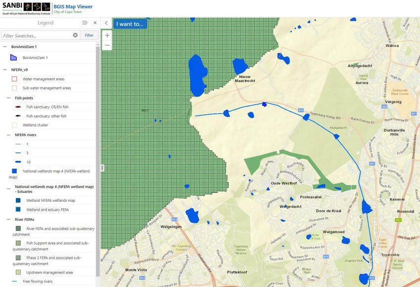
P a g e |5

1.2.     DECLARATION OF INDEPENDENCE

I, Antonia Belcher, as the appointed specialist hereby declare/affirm the correctness of the information provided
or to be provided as part of the application, and that I:

    •    in terms of the general requirement to be independent:
              o   other than fair remuneration for work performed/to be performed in terms of this application,
                  have no business, financial, personal or other interest in the activity or application and that there
                  are no circumstances that may compromise my objectivity; or
              o   am not independent, but another specialist that meets the general requirements set out in
                  Regulation 13 of GN No. 326 have been appointed to review my work (Note: a declaration by the
                  review specialist must be submitted);
    •    in terms of the remainder of the general requirements for a specialist, am fully aware of and meet all of
         the requirements and that failure to comply with any the requirements may result in disqualification;
    •    have disclosed/will disclose, to the Applicant, the Department and registered interested and affected
         parties, all material information that have or may have the potential to influence the decision of the
         Department or the objectivity of any report, plan or document prepared or to be prepared as part of the
         application;
    •    have ensured/will ensure that information containing all relevant facts in respect of the application
         was/will be distributed or was/will be made available to interested and affected parties and the public
         and that participation was/will be facilitated in such a manner that all interested and affected parties
         were/will be provided with a reasonable opportunity to participate and to provide comments;
    •    have ensured/will ensure that the comments of all interested and affected parties were/will be
         considered, recorded and submitted to the Department in respect of the application; and
    •    am aware that a false declaration is an offence in terms of Regulation 48 of the NEMA EIA Regulations,
         2014 (as amended).

Date:                                8 March 2021

Name of company:                     -

Signature of the specialists: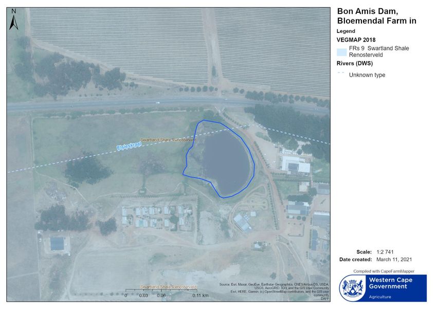
P a g e |6

2.      INTRODUCTION AND DESCRIPTION OF STUDY

2.1.    BACKGROUND TO THE STUDY

Remedial works are being proposed on the Bon Amis Dam on Portion 1 of Farm 1471 Bloemendal in Durbanville,
Cape Town (Figure 1). The proposed works comprise repairs to the spillway and dam wall. It is also necessary to
reshape the earth channel immediately downstream of the dam. The dam is an instream dam on the Elsieskraal
River. Longer-term maintenance of the channel and spillway will also be required.

The need for an aquatic ecologist to assess the proposed works and provide mitigation measures that will inform a
Maintenance Management Plan for the site was identified. This aquatic specialist report is thus intended to inform
the decision-making process on the potential impacts of the proposed activities on the surrounding freshwater
features.

                                                 Bon Amis Dam

Figure 1. Topographical map indicating the location of Bon Amis Dam

The Bon Amis Dam lies within a wider area considered of Very High Aquatic Biodiversity Sensitivity in terms of the
DEA Screening Tool. This is due to the fact that wetlands within the wider area have been mapped as Aquatic
Critical Biodiversity Areas (CBAs) and Freshwater Ecosystem Priority Area (FEPA) Wetlands. The area is also a
Strategic Water Source Area for groundwater (Cape Peninsula and Cape Flats). It is highly unlikely that the
activities would impact the Strategic Water Source Area. The Aquatic CBAs and FEPA mapped features are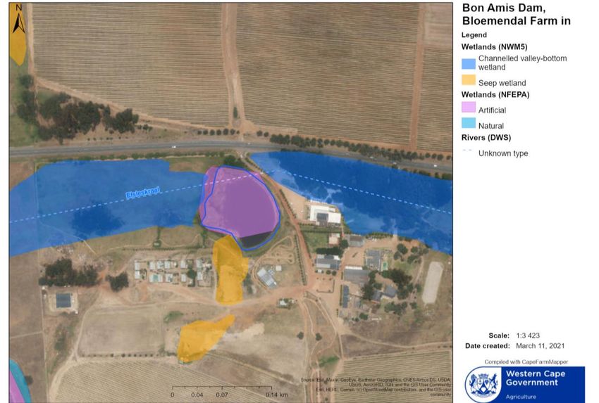
P a g e |7

discussed in Section 4.6 of this report. There are no aquatic CBAs on the site, both the valley bottom wetland
along the Elsieskraal River and the wetland area associated with the dam are indicated to be Critical and Other
Ecological Support Areas. The potential impact of the activities on the wetland areas associated with the
Elsieskraal River at the site is assessed in this report.

Table 1: Summary of key water resource information related to the site

Descriptor                       Name / details                                        Notes
Water Management Area            Berg - OlifantsWMA
Catchment Area                   Elsieskraal Tributary of the Black/Salt River
Quaternary Catchment             G22C
Present Ecological state         Elsieskraal River: F category (critically modified)   DWA 2012 – for larger tributary within
Ecological Importance and        Elsieskraal River: Low and Moderate                   urban area
Ecological Sensitivity
Type of water resource           Small watercourse and associated wetland
Latitude                         33°50'22.65"S                                         Bon Amis Dam wall
Longitude                        18°35'59.72"E

2.2.     TERMS OF REFERENCE

The Scope of Works for this aquatic ecosystem assessment is to provide an aquatic specialist report that informs
the Maintenance Management Plan for the project with regards to aquatic ecosystem impacts and recommended
mitigation measures associated with the proposed remediation works.

2.3.     METHODOLOGY

Input into this report was informed by a combination of desktop assessments of existing freshwater ecosystem
information for the study area and catchment, as well as a brief assessment of the freshwater features on the site.
The site was visited for single days in December 2010, April 2013, March 2016, September 2017 and again in
August 2019 in which the various assessments associated with the property and covered assessments of the site
under wet and dry conditions.

Mapping of the freshwater features within the site was undertaken using a Garmin handheld GPS tracking device
and refined on Google Earth and Planet GIS Professional. In addition, the latest mapping on the SANBI Biodiversity
GIS and CapeFarmMapper websites were consulted to identify any potential constraints relating to features of
conservation importance.

The following techniques and methodology utilised to undertake this study:

    •    Analysis of the freshwater ecosystems was undertaken according to nationally developed methodologies
         as defined by the Department of Water and Sanitation and the Water Research Commission for rivers.
         The assessments were undertaken at a rapid level which was deemed suitable to the level of assessment
         required for this report.

    •    No detailed water quality or aquatic life (fish and macroinvertebrates) integrity assessments were
         undertaken due to the absence of suitable habitat and flow conditions.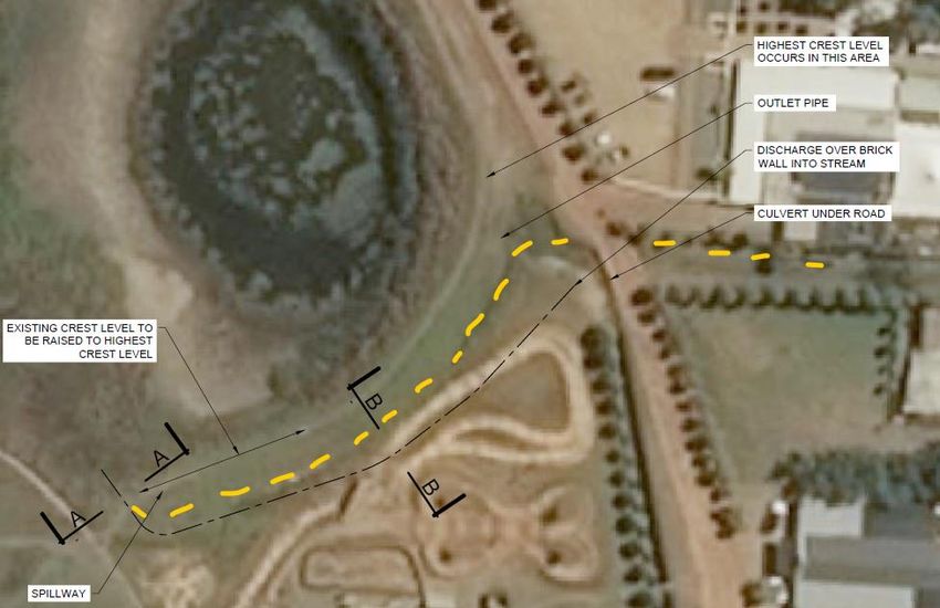
P a g e |8

     •   Recommendations are based on the ecosystem condition and ecological importance and sensitivity.
         These recommendations are based on professional opinion but are in line with the City of Cape Town’s
         river corridor and floodplain management policy and DWS methodologies.

Limitations and uncertainties often exist within the various techniques adopted to assess the condition of
ecosystems. The methods utilised are nationally developed methodologies and were deemed to be sufficient for
the level of assessment required to consider the impacts of the proposed works.

2.4.     USE OF THIS REPORT

This report reflects the professional judgment of its author. The report should be kept in its full and unedited form
and any summary of these findings should only be produced in consultation with the author.

3.       DESCRIPTION OF THE PROPOSED ACTIVITY

The spillway at Bon Amis Dam is currently not functioning properly and required remedial works. There is also a
danger that the toe of the dam wall will become eroded as a result of flooding. The proposed remedial works
entail the following activities:

•    Repair of the existing spillway - It is proposed to construct a concrete spillway approximately 400 mm deep
     and 7 meters wide (See Figure 2);

•    Reshaping and defining of the existing earth channel below the dam wall - The earth channel below the dam
     will need to be moved a few meters away from the dam wall because there is also a threat that the dam wall
     can be damaged in flood events. Figure 3 shows the design of the reshaping of the earth channel. The current
     earthen channel will be infilled;

•    Future maintenance of vegetation in earth channel and around the spillway; and
•    Future maintenance on the spillway.

Element Consulting Engineers have proposed that the works at Bon Amis Dam will consist of the following actions:

Cleaning of the site: The final position of the relocated spillway will be set out. The area will then be cleaned of
vegetation. The contractor will provide the necessary equipment required to remove the topsoil in the proposed
relocated spillway area. The depth of topsoil will be determined on-site. Any uncontaminated topsoil will be
stockpiled on site and maintained throughout the project in a weed-free condition. The stockpiles will be stored,
shaped and sited in such a way that they do not interfere with the flow of water to cause damming or erosion. At
the end of construction, the topsoil will be spread to ±150mm thick to cover the spillway embankments.

Earthworks: An excavator will be used to excavate a further ±0.5m deep to form the proposed relocated spillway.
Imported material will be used to form the embankments of the proposed spillway. On completion, the
compaction plant will compact the newly relocated spillway embankments and channel area. Afterward, the
embankments will be covered by the stockpiled topsoil.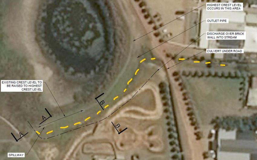
P a g e |9

Figure 2: Spillway design

Figure 3: Earth channel reshaping
P a g e | 10

Spillway beam: The reinforcing will be assembled and fixed to form the spillway beam. Shuttering will be placed
around the reinforcing. The dry material for the mixing of the concrete will be stockpiled on an area away from the
watercourse. The concrete for the spillway will be mixed in the stockpiled area. Damp-proof course (DPC) plastic
sheets and sand will be used to prevent soil contamination during the concrete mixing process. Wheelbarrows will
be used to transport the concrete to the desired area of construction. The cement run-off will be continuously
monitored when placing the concrete to prevent any cementitious run-off to the river. The area will be cleaned
from all plants and material before handover.

4.       GENERAL DESCRIPTION OF THE SURROUNDING CATCHMENT

4.1.     VISUAL CHARACTERISTICS

The farm is located in the upper catchment of the Elsieskraal River in the Black/Sand River Catchment (Figure 4).
The farm lies in the northern slopes of the Tygerberg Hills and is relatively steep becoming flat in the river valley
floor. The surrounding area to the site has largely been developed for agricultural purposes, where the dominant
land use of the area now is vineyards. Much of the middle to lower reaches of the river consists of urban areas of
Durbanville and Bellville.

                                                                                                Bon Amis Dam wall

Figure 4. View of the site, looking northwards over the Bon Amis Dam and the Elsieskraal River

4.2.     CLIMATE

Durbanville has a Mediterranean climate and receives about 475mm of rain per year, mostly during winter (Figure
5). It receives the lowest rainfall (8mm) in February and the highest (90mm) in June. The average midday
temperatures for Durbanville range from 16.2°C in July to 27.3°C in February. The region is the coldest during July
when the mercury drops to 7°C on average during the night.
P a g e | 11 The flow in the Elsieskraal River under natural conditions would have little to no flow in the period December to April and would have high flow conditions in the months of July and August. There are however several instream dams in the upper catchment that impede the low flow in the watercourse and delay the period in which the higher flow occurs in the watercourse such that today it is only likely to flow during June/July to September and remains mostly dry for the remaining months of the year except for some flow for short periods immediately following local rainfall events. Figure 5. Average rainfall (left) and temperature (right) graphs (CapeFarmMapper, 2021) Figure 6. Monthly flow distribution chart for the Elsieskraal River based on WR2012 modeled flow data 4.3. GEOLOGY AND SOIL The geology in the area consists largely of greywacke, phyllite and quartzitic sandstone of the Tygerberg Formation, Malmesbury Group with a surficial cover formed in situ on the Malmesbury rocks. The soils are generally red-and yellow-brown Oakleaf and Tukulu soils (Figure 7) with a restricted soil depth, allow for excessive drainage, have a moderate to high erodibility and a low natural fertility. These soils have a marked clay accumulation and are strongly structured. They are also conducive soils for the formation of wetland areas.
P a g e | 12

                                                          Bon Amis Dam

Figure 7. Broad soil map of the study area (CapeFarmMapper, 2021)

4.4.    FLORA

The natural vegetation on the site has been mapped by Mucina and Rutherford (2006) as Swartland Shale
Renosterveld (Critically endangered). Figure 8 shows the updated 2018 Vegetation Map. The vegetated cover has
however been completely modified and now consists largely of exotic grasses and cultivated areas (vineyards).
Mature exotic trees (predominantly poplar trees Populus x canescens) are also distributed throughout the site,
with the highest densities along the river channel. The vegetation under the poplar canopy comprises cobra lilies
(Chasmanthe aethiopica) and arums (Zantedeschia aethiopica). The vegetation along the watercourse comprises
largely of common reeds (Phragmites australis) while in the dam bulrushes (Typha capensis) dominates. Much of
the area surrounding the watercourse is dominated by invasive alien kikuyu grass (Pennisetum clandestinum).
P a g e | 13
Bon Amis Dam
Figure 8. Vegetation types at the site and surrounding area (CapeFarmMapper, 2021)
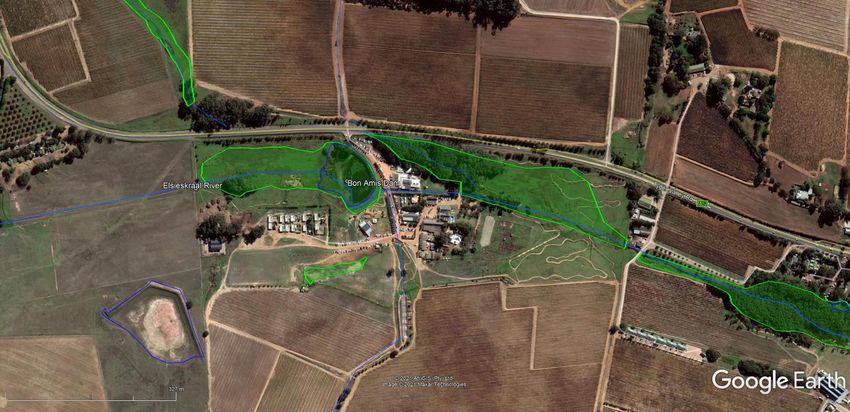
4.5. AQUATIC FEATURES
The aquatic feature associated with Bon Amis Dam is the Elisieskraal River and its associated wetland areas. The
Elsieskraal River flows through the Bloemendal and D’Aria Farms, arising to the west of the properties and draining
towards Bellville in the south-east. Much of the valley floor adjacent to the river comprises of valley bottom
wetland area and instream dams have been constructed within the wider wetland area (Figure 9). The aquatic
features within the property are typified by hydrophilic sedges and grasses that are adapted to waterlogged
conditions. Birdlife such as yellow-billed ducks, coots, dabchicks, egrets and herons makes use of the small
instream dam. An assessment of the aquatic features associated with the proposed activities is included in the
following section.P a g e | 14
Bon Amis Dam
Figure 9. Google Earth image showing the mapped water features on the siteP a g e | 15
4.6. LAND USE
Bloemendal Farm lies outside of the urban edge of the City of Cape Town (Figure 10). Land use in the area consists
primarily of agricultural development (vineyards) but the area is becoming increasingly developed for urban
development (residential and commercial) associated with Durbanville. Some thicket vegetation and wetland areas
occur along the river corridor. The 2014 Spatial Development Plan for the City has zoned the area as being ‘High
Potential and Unique Agricultural Land’.
Bon Amis Dam
Figure 10. Landcover Map for the site (CapeFarmMapper, 2021)
4.7. CONSERVATION IMPORTANCE
Two sets of conservation mapping results are of relevance to the national and provincial identification of the
ecological importance that has been attributed to the freshwater features in the study area. The City of Cape Town’s
(CCT) Biodiversity Network mapping and the National Freshwater Ecosystem Priority Areas map. The Biodiversity
Network map aims to guide sustainable development by providing a synthesis of biodiversity information to decision-
makers to ensure appropriate land use and planning for the best possible long-term benefits and to promote
integrated management of natural resources. The main categories are Critical Biodiversity Areas (CBAs - Terrestrial
and Aquatic), Ecological Support Areas (ESAs - Critical and Other), Other Natural Remaining Areas and No Natural
Remaining Areas. The first two mentioned categories represent the biodiversity priority areas that should beP a g e | 16
maintained in a natural to near-natural state. The last two mentioned categories are not considered as priority areas
and a loss of biodiversity within these areas may be acceptable.
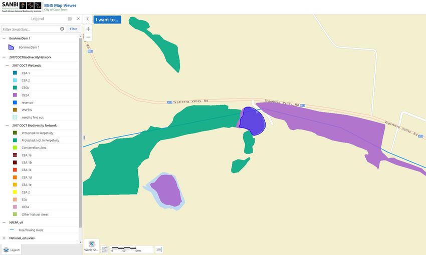
Natural and semi-natural wetland areas along the Elsieskraal River in the upper portion of the farm, are mapped as
Critical ESAs while the wetlands at the dam and in the downstream river corridor and are mapped as Other ESAs
(Figure 12). These areas are important for the provision of ecological services and are associated with the river
corridor as a migration corridor for the movement of water and associated biota in a transformed landscape.
Bon Amis Dam
Figure 11. City of Cape Town Spatial Biodiversity Plan for the site (SANBI Biodiversity GIS, 2021)
The National Freshwater Ecosystem Priority Areas initiative identified freshwater resources which should be protected
against modification. Freshwater Ecosystem Priority Areas (FEPAs) were determined through a process of systematic
biodiversity planning and were identified using a range of criteria for serving ecosystems and associated biodiversity
of rivers, wetlands and estuaries. FEPAs are intended to provide strategic spatial priorities for conserving South
Africa’s freshwater ecosystems and supporting the sustainable use of water resources. Although the neighbouring
catchment of the Diep River is mapped as FEPA River, the Elsieskraal River catchment is not a FEPA River (Figure 12).
The FEPA wetlands mapped within the valley are largely associated with the instream dams (Figure 13). The wider
valley bottom wetland has been mapped in the National Wetland Map with some hillslope seeps occurring on the
lower hillslope to the south of the dam.P a g e | 17
Bon Amis Dam
Figure 12. FEPA River mapping for the site (SANBI Biodiversity GIS, 2021)
Figure 13. FEPA Wetland and National Wetland Map for the site (CapeFarmMapper, 2021)P a g e | 18 5 RESULTS OF AQUATIC ECOSYSTEM ASSESSMENT 5.1. DESCRIPTION OF FRESHWATER FEATURES ASSESSED The Elsieskraal River originates in the Tygerberg Hills and flows in its upper reaches through agricultural lands and past the occasional low density upmarket residential development of the Durbanville Hills to Doordekraal Dam. Downstream of the Doordekraal Dam the river flows through the suburbs of Durbanville and Bellville, where residential densification and the encroachment of commercial developments on the riverbank occurs. After passing under the N1 and the suburbs of Goodwood and Pinelands, the stream is canalised and joins the Black/Vygekraal River complex close to the N2 downstream of the Athlone WWTW discharge point. The early images of the farm from 1944 (Figure 14) show the river and its associated riparian zone to be much as it is today, with the area had been significantly transformed by agricultural activities. The number of relatively large instream dams have since been constructed in the river channel and the growth of invasive alien trees along the river corridor has increased substantially since then. Figure 14. An aerial photograph taken 1944 overlain in Google Earth with the mapped aquatic features (blue line=watercourse and blue polygons=dams) The river within the study area is generally flat with a wide riparian zone that contains associated wetland areas. The channel is overgrown with exotic grasses such as kikuyu and patches of riverbed grass, sedges, arums and bulrush (Figure 16). The instream Bon Amis Dam, dominated by bulrushes, has been constructed within the channel upstream of the Bloemendal building complex. Several small tributaries feed the Elsieskraal River from the adjacent hillslopes.
P a g e | 19

Figure 15. View of the Elsieskraal River upstream of Bon Amis Dam

5.2      RIVER HEALTH ASSESSMENT

The methodologies used in the river health assessment are included in Appendix 1. From the Site Characterisation
assessment, Table 3, the geomorphological and physical characteristics of the upper Elsieskraal River can be classified
as a modified and confined foothill river.

Table 2. Geomorphological and Physical features of the Elsieskraal River at Bon Amis Dam

 Geomorphological Zone    Foothill Zone
 Lateral mobility         Semi-confined
 Channel form             Simple (no macro channel)
 Channel pattern          Single-channel, low sinuosity
 Channel type             Sand
 Channel modification     Significant modification from surrounding agriculture, with infilling and alien plant invasion
 Hydrological type        Seasonal
 Ecoregion                South Western Coastal Belt
 DWA catchment            G22C
 Vegetation type          Swartland Shale Renosterveld
 Rainfall region          Winter

The evaluation of Habitat Integrity (HI) provides a measure of the degree to which a river has been modified from its
natural state. For a description of the methodology refer to Appendix 2. The scores for the instream and riparian zone
components of the habitat integrity are given in Table 4.
P a g e | 20

Table 3. Index of Habitat Integrity Assessment for the Elsieskraal River at Bloemendal and D’Aria

Instream Criteria                Weight            Score          Riparian Zone Criteria            Weight       Score
Water abstraction                14                12             Water abstraction                 13           12
Flow modification                13                12             Inundation                        11           11
Bed modification                 13                10             Flow modification                 12           12
Channel modification             13                13             Water quality                     13           12
Water quality                    14                12             Indigenous vegetation removal     13           8
Inundation                       10                11             Exotic vegetation encroachment    12           12
Exotic macrophytes               9                 8              Bank erosion                      14           4
Exotic fauna                     8                 2              Channel modification              12           11
Solid waste disposal             6                 6
Category                                           D              Category                                       E

The instream habitat integrity of the river is largely modified while the riparian zone is seriously modified. The major
impact to the habitat integrity is the modification of the bed and channel as well as a loss of indigenous riparian
vegetation as a result of the surrounding farming and peri-urban activities. Flow, water quality and invasive alien
plants also impact on the integrity of the aquatic habitat.

5.3.     ECOLOGICAL IMPORTANCE AND SENSITIVITY

The Ecological Importance and Sensitivity EIS assessment considers several biotic and habitat determinants surmised
to indicate either importance or sensitivity (See Appendix 2 for more information). The results of this assessment are
provided in Table 5. Knowledge of the biota and habitat present in the river system is based on existing river health
data collected as part of the National River Health Programme.

Table 4. Results of the EIS assessment: Elsieskraal River

Biotic Determinants                                                                                          Score
Rare and endangered biota                                                                                    1
Unique biota                                                                                                 1
Intolerant biota                                                                                             1
Species/taxon richness                                                                                       1
Aquatic Habitat Determinants
Diversity of aquatic habitat types or features                                                               2
Refuge value of habitat type                                                                                 2
Sensitivity of habitat to flow changes                                                                       2
Sensitivity of flow related water quality changes                                                            2
Migration route/corridor for instream & riparian biota                                                       1
National parks, wilderness areas, Nature Reserves, Natural Heritage sites, Natural areas, PNEs               1
RATINGS                                                                                                      1.4
EIS CATEGORY                                                                                                 Moderate

The ecological importance and sensitivity of the stream assessed are considered to be moderate. Due to the already
modified state of this river system, most of the biota occurring in the river is relatively hardy species. Indigenous fish
species such as Cape galaxias (Galaxia zebratus) do still occur within the river but are threatened by alien fish that
have specifically been stocked within the dams in the river.
P a g e | 21

5.4.     RECOMMENDED ECOLOGICAL CONDITION OF AQUATIC FEATURES

There are no watercourses listed in the proposed Resource Quality Objectives for the Berg Water Management Area
for Quaternary Catchment G22C in which the site is located. The recommended target ecological condition for the
adjacent rivers within the larger G22 catchment are primarily a C Category (moderately modified) or D Category
(largely modified). Given the present ecological condition of the Elsieskraal River that is in a D/E Category (Largely to
seriously modified) and the moderate EIS, it is recommended that the river corridor be rehabilitated to at least a D
Category. If adequately mitigated, the proposed development on the site would be unlikely to impact this
recommended ecological condition and does provide an opportunity for rehabilitation of the associated aquatic
features.

6.       AQUATIC IMPACT ASSESSMENT

6.1.     DESCRIPTION OF IMPACTS

This section provides an assessment of the impacts to freshwater ecosystems that are likely to be associated with
proposed activities. The methodology for the impact assessment is included in Appendix 2. Short-term disturbance to
aquatic habitat at the dam as well as some water quality and possibly flow impacts may occur. These shorter-term
impacts are likely to be of a low significance, particularly considering that the works are to take place within the highly
disturbed and modified aquatic habitat at the dam. No significant longer-term impacts are expected during the
operation phase. The proposed works are also to address the potential erosion that may take place at the dam as well
as to undertake routine maintenance works (clearing of nuisance vegetation and sediment and maintenance of
infrastructure) at the dam.

6.1.1. IMPACTS ASSOCIATED WITH THE PROPOSED REPAIRS TO BON AMIS DAM

The proposed works entail the replacement of the existing earth spillway with a shaped concrete spillway. The
repaired spillway will require the existing channel from the dam to be moved slightly southwards. The alignment of
the existing channel immediately adjacent to the dam is indicated by the yellow dashed line in Figure 16. The
alignment of the new proposed channel is shown as the black dashed line in Figure 16. The realignment of the channel
will only take place in the section immediately adjacent to the dam, to rejoin the existing channel downstream of the
dam.
P a g e | 22

Figure 16. Diagram indicating the alignment of the existing channel (yellow dashed line) and the proposed new
alignment of the channel (black dashed line)

NATURE OF IMPACT: DISTURBANCE OF AQUATIC HABITAT AND SHORT-TERM WATER QUALITY IMPACTS

A potential disturbance of aquatic habitat could be expected during the construction phase of the project due to the
proposed realignment of the channel adjacent to the dam (see Figure 19). During construction contaminated water or
water with high sediment loads could also potentially drain into the downstream aquatic habitat. There is a slight
potential for flow from the dam to be impacted during the construction.

Significance of impacts without mitigation: The proposed works are to take place in aquatic habitat at the dam that is
in a largely to severely modified ecological state, thus the potential impact is likely to be low. The impacts will occur in
the construction phase. Little to no operation impacts are expected to occur.

Proposed mitigation:

    •    The channel shaping and realignment is supported;

    •    It is recommended that the works are undertaken at the end of the dry season and just before the onset of
         the wetter winter months to facilitate the regrowth of cover vegetation without the need to irrigate it.

    •    The construction activities should be limited as far as possible to the modified habitats at the dam. The
         realigned and reshaped channel downstream of the new spillway should be revegetated with preferably
         indigenous grass such as Cynodon dactylon after construction. Cynodon is a low-growing grass that requires
         little maintenance, grows in seasonally inundated areas and tends to be non-invasive in the Western Cape. It
         is also a good plant species in preventing erosion. It is recommended that some wetland vegetation such as
P a g e | 23
Cyperus textilis and Bolboschoenus maritimus be planted in the bed of the channel on the lower slope where
the erosion potential is low.
• The topsoil in the existing channel (approx. 150 mm to 200mm) should be removed and replaced within the
new channel before it is revegetated. The kikuyu grass in the existing channel should first be sprayed with a
herbicide such as Agil at least two weeks before construction commences to reduce the potential for its
regrowth within the new channel. The topsoil should be stockpiled at least 10m away from any aquatic
features at the site.
• Any imported material used for construction should be certified to be seed-free to prevent the further
introduction of alien vegetation to the channel.
• Mixing of concrete at the site should take place at least 10m away from any aquatic features.
• Good housekeeping measures should be in place during construction. All materials associated with the
construction works should be properly stored and contained. Disposal of waste from the site should also be
properly managed. Construction workers should be given ablution facilities at the construction sites that are
located away from any aquatic features (at least 30m) and regularly serviced. These measures should be
addressed, implemented and monitored in terms of the Environmental Management Programme (EMP) for
the construction phase.
• It may be necessary to place a temporary sediment trap to prevent sediment from blocking the channel,
particularly in the downstream culvert at the road.
• All waste materials associated with construction activities should be removed after the construction phase is
complete.
Significance of impacts after mitigation: The significance of the impact on the aquatic ecosystems with mitigation is
expected to be very low.
Repair works to dam spillway and realignment of downstream channel
Potential impact and risk:
at the dam
CONSTRUCTION PHASE
Short-term disturbance to aquatic habitat at the dam as well as some
Nature of impact:
water quality and possibly flow impacts may occur
Duration of impact: Short term
Extent Site
Magnitude/Intensity Low to Very low
Consequence of impact or risk: Temporary disturbance of modified aquatic habitat at the dam
Probability of occurrence: Probable
Degree to which the impact may cause irreplaceable
No loss
loss of resources:
Degree to which the impact can be reversed: Partially reversible
Opportunity for introduction of alien vegetation. The proposed works
Indirect impacts:
is to reduce the erosion potential at the dam.
Cumulative impact prior to mitigation: Low to very low
Significance rating of impact prior to mitigation Low to very low negative
Degree to which the impact can be avoided: Low
Degree to which the impact can be managed: High
Degree to which the impact can be mitigated: High
Proposed mitigation: See above
Residual impacts: Realigned channelP a g e | 24
Cumulative impact post-mitigation: Very Low
Very Low with a potential positive impact associated with reduced
Significance rating of impact after mitigation
erosion potential at the dam
Confidence High
6.1.2. IMPACTS ASSOCIATED WITH THE PROPOSED MAINTENANCE OF INFRASTRUCTURE AT THE
DAM
The proposed maintenance works at the dam comprise of periodic clearing of nuisance vegetation and debris at the
dam and its associated infrastructure. The primary impact of clearing of nuisance material and debris as well as the
undertaking of any repair works to the infrastructure is the disturbance of riparian and aquatic habitat. The clearing of
vegetation and material within aquatic habitats can be conducted in several different ways. The level of impact of
clearing varies depending on the methods used. For example, a bulldozer can be used to do the clearing but, in the
process, all other plants are removed, and the habitat completely modified. The result is a much higher impact than if
the clearing had been undertaken by hand which would have a very low impact. Secondary impacts would be the
potential to cause increased sedimentation and even erosion of the cleared and surrounding areas and the potential
to facilitate the invasion of the area by alien plant species.
The most successful method for control of Typha is through a physical cutting in conjunction with flooding/inundation
of reedbed. Cutting and/or burning should take place at the end of autumn when water levels are low but when the
cut area will be submerged in at least 10 cm of water when water levels rise again. Two subsequent cuttings of the
bulrush will be required within the end of the growing season to suppress the regrowth before the inundation. Pulling
of bulrush can work where the plants are small seedlings.
Significance of impacts without mitigation: Low
Proposed mitigation specific to the removal of nuisance indigenous vegetation:
• The removal of nuisance indigenous instream vegetation should where possible be conducted by hand-
cutting/mowing to avoid the large-scale disturbance of soil and removal of vegetated material.
• Clearing should be limited to the banks of the dam and within the downstream channel;
• Clearing by hand should be conducted at the end of summer and should not be conducted more than once a
year. The reeds should be cut below the lowest leaf and the remaining stump should not be longer than
15cm. If a brush cutter is used, mowing should be no lower than 12cm from the ground to minimise impacts
to small animals and indigenous plants;
• If mowers are used, care should be taken that they do not damage banks or other indigenous vegetation such
as sedges and rushes;
• Mechanical clearing of plants, if this is deemed necessary, should be less frequent than annually and should
be limited in extent (the entire extent of the reedbed should not be cleared, only a portion thereof);
General mitigation measures for the repair work to infrastructure, clearing of vegetation and removal of material from
the dam and watercourse at the dam:P a g e | 25
• Minimise the spatial extent of disturbance and the frequency thereof, or the requirement for, maintenance
activities;
• Repairs should be preferably conducted during the dry period (November/December to February/March)
when there is a lower flow;
• Manual labour is preferred to the use of mechanical equipment to minimise physical disturbance around the
activity location;
• Good house-keeping practices should be followed such as the use of machinery which does not leak oils or
other substances, and if applicable adequate waste disposal and removal, as well as the adequate provision
and servicing of toilets. The site of the maintenance activity must be managed so that construction material
(especially cement and fuel products) is not washed into the watercourse during storm events. Emergency
spill kits should be kept on-site;
• The maintained infrastructure should not impact on the structural integrity of the watercourse nor result in
any alteration to its flow- and sediment carrying-capacity;
• While the work is being carried out; if required, temporary sediment trapping should be put in place to filter
water in the channel which will most likely contain high sediment loads;
• The upstream and downstream impacts of any vegetation clearing activities should be minimized, such as the
prevention of increased sedimentation downstream of the site by not undertaking the activity during the
rainy period;
• If banks are disturbed by the activity, follow-up revegetation may need to be undertaken. Indigenous sedges
and other grasses should be allowed to establish in cleared sections
• Any cleared sediment, vegetation, or spoil material associated with the maintenance activity should be
removed away from the aquatic features, preferably to an approved disposal site;
• Clear alien plants to encourage regrowth of indigenous species; and
• All reasonable measures should be undertaken to ensure that the maintenance activities minimise future
erosion of the watercourse.
Significance of impacts after mitigation: Very Low
Maintenance works at the dam, including repairs to the infrastructure,
Potential impact and risk:
clearing of material and nuisance vegetation
OPERATION PHASE
Short-term disturbance to aquatic habitat as well as some water
Nature of impact:
quality and possibly flow impacts may occur
Duration of impact: Short term
Extent Site
Magnitude/Intensity Low to Very low
Consequence of impact or risk: Temporary disturbance of modified aquatic habitat at the dam
Probability of occurrence: Possible
Degree to which the impact may cause irreplaceable
No loss
loss of resources:
Degree to which the impact can be reversed: Reversible
Indirect impacts: Opportunity for introduction of alien vegetation or increased erosionP a g e | 26
potential.
Cumulative impact prior to mitigation: Low to very low
Significance rating of impact prior to mitigation Low to very low negative
Degree to which the impact can be avoided: High
Degree to which the impact can be managed: High
Degree to which the impact can be mitigated: High
Proposed mitigation: See above
Residual impacts: None
Cumulative impact post-mitigation: Very Low
Significance rating of impact after mitigation Very Low
Confidence High
6.2. CONSIDERATION OF ALTERNATIVES
The No-Go Alternative would imply that the risk of erosion at the dam would not be repaired, nor would the
landowner be in a position to undertake repairs at the dam. This would increase the impact of damage to the
downstream aquatic habitat. The undertaking of the proposed activities at the dam is thus likely to result in a lesser
ecological impact on the aquatic habitat associated with the dam.
7. RISK ASSESSMENT
Considering the scope of works undertaken and the condition of the watercourse at the site, the risk of the proposed
activities is considered to be low provided the recommended mitigation/rehabilitation measures are implemented.
The proposed activities thus fall within the ambit of the General Authorisations for Section 21(c) and (i) water uses.
Table 5. A summary of the risk assessment for the proposed pipelines (See Appendix 3 for Full Risk Matrix)
Phases Activity Aspect Impact Significance Risk Rating
Construction Construction works Repair spillway Aquatic habitat; 32.5 L
associated with Realign channel at the flow and water 37.5
proposed spillway dam quality impacts L
repairs associated with
Operation Maintenance Clearing of nuisance dam and in the 37.5
L
activities at the dam vegetation Elsieskraal River
Clearing of sediment and directly upstream 35
and downstream L
other material
Repairs to infrastructure of the dam 30
8. CONCLUSIONS AND RECOMMENDATIONS
The Elsieskraal River at Bloemendal is in a largely to seriously modified state and has a moderate ecological
importance and sensitivity. The site is not located in a FEPA River sub-catchment and the mapped FEPA wetlands
within the valley are largely associated with the instream dams. In terms of the City Biodiversity Spatial Plan, the
wetland areas along the Elsieskraal River at the dam are mapped as Critical and Other ESAsP a g e | 27
Short-term disturbance to aquatic habitat at the dam as well as some water quality and possibly flow impacts may
occur that would be associated with the proposed repairs and maintenance to the Bon Amis Dam. These shorter-term
impacts are likely to be of a low significance, particularly considering that the works are to take place within the highly
disturbed and modified aquatic habitat at the dam. No significant longer-term impacts are expected during the
operation phase. The proposed works are also to address the potential erosion that may take place at the dam as well
as to undertake routine maintenance works (clearing of nuisance vegetation and sediment and maintenance of
infrastructure) at the dam that would likely be of benefit to the downstream aquatic habitat.
The recommended mitigation to address the potential aquatic ecosystem impacts are provided below:
• The channel shaping and realignment is supported;
• It is recommended that the works are undertaken at the end of the dry season and just before the onset of
the wetter winter months to facilitate the regrowth of cover vegetation without the need to irrigate it.
• The construction activities should be limited as far as possible to the modified habitats at the dam. The
realigned and reshaped channel downstream of the new spillway should be revegetated with preferably
indigenous grass such as Cynodon dactylon after construction. Cynodon is a low-growing grass that requires
little maintenance, grows in seasonally inundated areas and tends to be non-invasive in the Western Cape. It
is also a good plant species in preventing erosion. It is recommended that some wetland vegetation such as
Cyperus textilis and Bolboschoenus maritimus be planted in the bed of the channel on the lower slope where
the erosion potential is low.
• The topsoil in the existing channel (approx. 150 mm to 200mm) should be removed and replaced within the
new channel before it is revegetated. The kikuyu grass in the existing channel should first be sprayed with a
herbicide such as Agil at least two weeks before construction commences to reduce the potential for its
regrowth within the new channel. The topsoil should be stockpiled at least 10m away from any aquatic
features at the site.
• Any imported material used for construction should be certified to be seed-free to prevent the further
introduction of alien vegetation to the channel.
• Mixing of concrete at the site should take place at least 10m away from any aquatic features.
• Good housekeeping measures should be in place during construction. All materials associated with the
construction works should be properly stored and contained. Disposal of waste from the site should also be
properly managed. Construction workers should be given ablution facilities at the construction sites that are
located away from any aquatic features (at least 30m) and regularly serviced. These measures should be
addressed, implemented and monitored in terms of the Environmental Management Programme (EMP) for
the construction phase.
• It may be necessary to place a temporary sediment trap to prevent sediment from blocking the channel,
particularly in the downstream culvert at the road.
• All waste materials associated with construction activities should be removed after the construction phase is
complete.
Mitigation specific to the removal of nuisance indigenous vegetation:P a g e | 28
• The removal of nuisance indigenous instream vegetation should where possible be conducted by hand-
cutting/mowing to avoid the large-scale disturbance of soil and removal of vegetated material.
• Clearing should be limited to the banks of the dam and within the downstream channel;
• Clearing by hand should be conducted at the end of summer and should not be conducted more than once a
year. The reeds should be cut below the lowest leaf and the remaining stump should not be longer than
15cm. If a brush cutter is used, mowing should be no lower than 12cm from the ground to minimise impacts
to small animals and indigenous plants;
• If mowers are used, care should be taken that they do not damage banks or other indigenous vegetation such
as sedges and rushes;
• Mechanical clearing of plants, if this is deemed necessary, should be less frequent than annually and should
be limited in extent (the entire extent of the reedbed should not be cleared, only a portion thereof);
General mitigation measures for the repair work to infrastructure, clearing of vegetation and removal of material from
the dam and watercourse at the dam:
• Minimise the spatial extent of disturbance and the frequency thereof, or the requirement for, maintenance
activities;
• Repairs should be preferably conducted during the dry period (November/December to February/March)
when there is a lower flow;
• Manual labour is preferred to the use of mechanical equipment to minimise physical disturbance around the
activity location;
• Good house-keeping practices should be followed such as the use of machinery which does not leak oils or
other substances, and if applicable adequate waste disposal and removal, as well as the adequate provision
and servicing of toilets. The site of the maintenance activity must be managed so that construction material
(especially cement and fuel products) is not washed into the watercourse during storm events. Emergency
spill kits should be kept on-site;
• The maintained infrastructure should not impact on the structural integrity of the watercourse nor result in
any alteration to its flow- and sediment carrying-capacity;
• While the work is being carried out; if required, temporary sediment trapping should be put in place to filter
water in the channel which will most likely contain high sediment loads;
• The upstream and downstream impacts of any vegetation clearing activities should be minimized, such as the
prevention of increased sedimentation downstream of the site by not undertaking the activity during the
rainy period;
• If banks are disturbed by the activity, follow-up revegetation may need to be undertaken. Indigenous sedges
and other grasses should be allowed to establish in cleared sections
• Any cleared sediment, vegetation or spoil material associated with the maintenance activity should be
removed away from the aquatic features, preferably to an approved disposal site;P a g e | 29
• Clear alien plants to encourage regrowth of indigenous species; and
• All reasonable measures should be undertaken to ensure that the maintenance activities minimise future
erosion of the watercourse.
Considering the scope of works undertaken and the condition of the watercourse at the site, the risk of the proposed
activities is considered to be low provided the recommended mitigation/rehabilitation measures are implemented.
The proposed activities thus fall within the ambit of the General Authorisations for Section 21(c) and (i) water uses.
9. REFERENCES
Cape Farm Mapper. http://gis.elsenburg.com/apps/cfm/.
City of Cape Town. 2009. Floodplain and River Corridor Management Policy. Roads and Stormwater Department.
City of Cape Town 2011. Cape Town Spatial Development Framework Statutory Report.
City of Cape Town. 2012. Final Draft Northern District Plan: Spatial Development Plan & Environmental Management
Framework, Technical Report.
Department of Water Affairs and Forestry. (1998). National Water Act. Act 36. South Africa.
Department of Water Affairs and Forestry. 1999. Resource Directed Measures for Protection of Water Resources.
Volume 3: River Ecosystems Version 1.0. Resource Directed Measures for Protection of Water Resources, Pretoria,
South Africa.
Department of Water Affairs and Forestry. 2005. River Ecoclassification: Manual for Ecostatus Determination (Version
1). Water Research Commission Report Number KV 168/05. Pretoria.
Department of Water Affairs and Forestry. (2016). Government Gazette No. 40229. Impeding or Diverting the Flow of
Water in a Watercourse [Section 21(c)] and Altering the Bed, Banks, Course or Characteristics of a Watercourse
[Section 21(i)]. Pp 105-136, Pretoria.
Department of Water Affairs and Forestry. (2019). Government Gazette Notice 655 of 2019. Proposed Classes of
Water Resources for the Berg River.
Driver, Nel, Snaddon, Murray, Roux, Hill. (2011). Implementation Manual for Freshwater Ecosystem Priority Areas.
Draft Report for the Water Research Commission.
Ellis, F. (2009). Wetland soils variation in the Cape, Department of Soil Science, University of Stellenbosch, Elsenburg
Freshwater Biodiversity Information System. https://freshwaterbiodiversity.org/map/
Kleynhans CJ (1996). A qualitative procedure for the assessment of the Habitat Integrity status of the Luvuvhu River
(Limpopo system, South Africa). Journal of Aquatic Ecosystem Health 5: 41-54.You can also read