Visual Impact Report: Proposed Nuweveld West Wind Farm - ASHA Consulting
←
→
Page content transcription
If your browser does not render page correctly, please read the page content below
Proposed Nuweveld Wind Energy Farms
          Western Cape Province
              for Red Cap (Pty) Ltd

      Visual Impact Report:
Proposed Nuweveld West Wind Farm
                   April 2021

                  Prepared for
          Aurecon South Africa (Pty) Ltd

                   Prepared by
             Quinton Lawson Architect
      Bernard Oberholzer Landscape Architect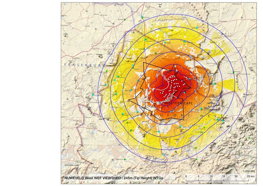
NEMA requirements for Specialist Reports

              Specialist Report content as required by the NEMA 2014 EIA Regulations, as amended                             Section

1 (1)(a)      (i) the specialist who prepared the report; and
              (ii) the expertise of that specialist to compile a specialist report including a curriculum vitae;             Page 3

      (b)     a declaration that the specialist is independent in a form as may be specified by the competent authority;     Page 4
      (c)     an indication of the scope of, and the purpose for which, the report was prepared;
                                                                                                                             Section 1

      (cA)    an indication of the quality and age of the base data used for the specialist report;
                                                                                                                             Section 3

      (cB)    a description of existing impacts on the site, cumulative impacts of the proposed development and
                                                                                                                             Section 12 and 14
              levels of acceptable change;
      (d)     the duration, date and season of the site investigation and the relevance of the season to the outcome
                                                                                                                             Section 4
              of the assessment;
      (e)     a description of the methodology adopted in preparing the report or carrying out the specialised process,
                                                                                                                             Section 2
              inclusive of equipment and modelling used;
      (f)     details of an assessment of the specific identified sensitivity of the site related to the proposed activity
                                                                                                                             Sections 11 - 14
              or activities and its associated structures and infrastructure, inclusive of a site plan identifying site
                                                                                                                             and maps
              alternatives;
      (g)     an identification of any areas to be avoided, including buffers;                                               Section 11
              a map superimposing the activity including the associated structures and infrastructure on the
      (h)                                                                                                                    Maps 7-10, 14
              environmental sensitivities of the site including areas to be avoided, including buffers;
      (i)     a description of any assumptions made and any uncertainties or gaps in knowledge;                              Section 5
      (j)     a description of the findings and potential implications of such findings on the impact of the proposed
                                                                                                                             Section 17
              activity, or activities;
      (k)     any mitigation measures for inclusion in the EMPr;
                                                                                                                             Section 15

      (l)     any conditions for inclusion in the environmental authorisation;                                               Sections 16
      (m)     any monitoring requirements for inclusion in the EMPr or environmental authorisation;                          Section 16
      (n)     a reasoned opinion-
              (i) whether the proposed activity or portions thereof should be authorised; and
              (iA) regarding the acceptability of the proposed activity or activities; and
                                                                                                                             Sections 16 and 17
              (ii) if the opinion is that the proposed activity or portions thereof should be authorised, any avoidance,
              management and mitigation measures that should be included in the EMPr, and where applicable, the
              closure plan;
      (o)     a description of any consultation process that was undertaken during the course of preparing the
                                                                                                                             Refer to EAP
              specialist report;
      (p)     a summary and copies of any comments received during any consultation process and where
                                                                                                                             Refer to EAP
              applicable all responses thereto; and
      (q)     any other information requested by the competent authority.                                                    N/A
2             Where a government notice gazetted by the Minister provides for any protocol or minimum information            Government Notice No.
              requirement to be applied to a specialist report, the requirements as indicated in such notice will apply.     320 has been gazetted
                                                                                                                             and therefore, a
                                                                                                                             verification report
                                                                                                                             aligned with the
                                                                                                                             requirements have
                                                                                                                             been included in this
                                                                                                                             report (Appendix B)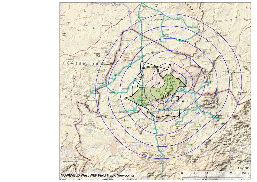
Contents
1    Purpose And Scope Of The Visual Impact Assessment Report                      5
2    Visual Assessment Methodology                                                 5
3    Sources Of Information                                                        5
4    Site Investigation                                                            6
5    Assumptions And Uncertainties                                                 6
6    Regulatory Framework                                                          6
7    Description Of The Proposed Wind Farm Project                                 6
8    Description Of The Study Area                                                10
9    Visual Features Mapping                                                      12
10   General Guidelines For Wind Farms                                            13
11   Visual Sensitivity Mapping                                                   13
12   Potential Visual Impacts                                                     15
13   Visual Impact Criteria                                                       16
14   Visual Impact Assessment                                                     20
15   Visual Mitigation Measures                                                   26
16   Environmental Management Programme                                           27
17   Conclusion And Recommendations                                               27
     References                                                                   31
     Appendix A: Assessment Criteria                                              32
     Appendix B: Site Verification Report                                         33
     Appendix C: Visual Specialists                                               36

Tables
Table 1: Nuweveld West WEF Components
Table 2: Visual Features and Sensitive Receptors
Table 3: Visual Buffers for Wind Turbines
Table 4: Visual Sensitivity Mapping Categories for Wind Turbines
Table 5: Visual Sensitivity Mapping Categories for Buildings and Substation
Table 6: Visual Sensitivity Mapping Categories for Internal Overhead Powerlines
Table 7: Visual Sensitivity Mapping Categories for Access Roads
Table 8: Visual Sensitivity Mapping Categories for N1 Bypass Road
Table 9: Viewpoints and Distances to Proposed Nuweveld West WEF
Table 10: Visual Impact Intensity
Table 11: Visual Impact Assessment: Construction Phase – Wind Turbines
Table 12: Visual Impact Assessment: Construction Phase – Infrastructure
Table 13: Visual Impact Assessment: Operation Phase – Wind Farm
Table 14: Visual Impact Assessment: Operation Phase – Infrastructure
Table 15: Visual Impact Assessment: Operation Phase – Lighting
Table 16: Visual Impact Assessment: Operation Phase – N1 Bypass Road
Table 17: Visual Impact Assessment: Decommissioning Phase
Table 18: Summary of Potential Visual Impacts

Figures
Figure 1: 3D Models: Wind Turbines at a range of Distances
Figure 2: 3D Models: Notional Substation and Switching Station
Figures 3-5: Viewpoint Panoramas

                                                                                   3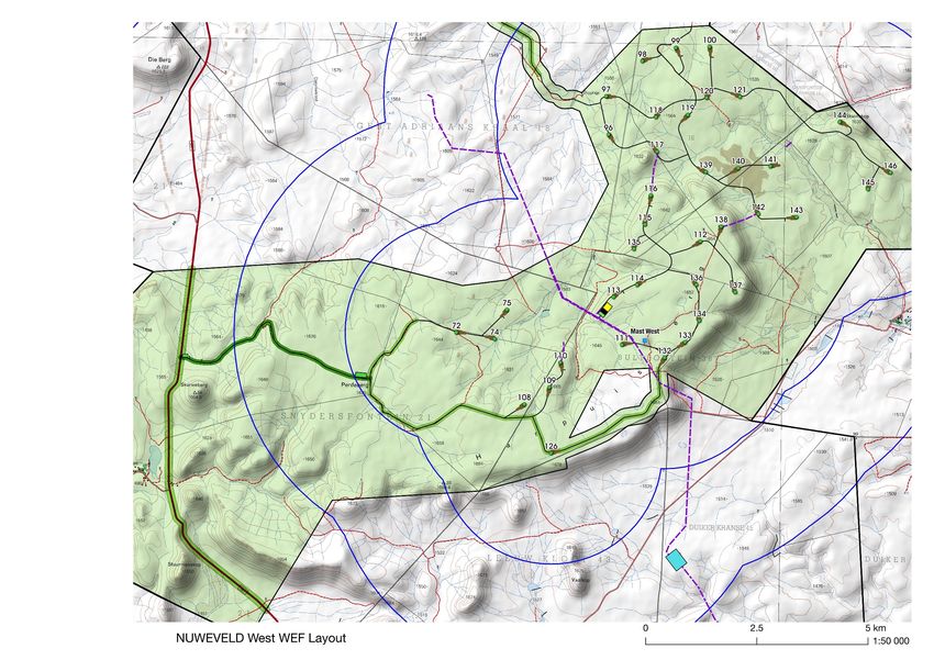
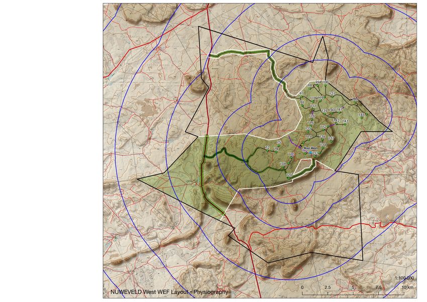
Maps
Map 1: Nuweveld West WEF: Location and Context
Map 2: Nuweveld West WEF: Field track and Viewpoints
Map 3: Nuweveld West WEF: Physiography
Map 4: Nuweveld West WEF: Layout
Map 5: Nuweveld West WEF: Viewshed
Map 6: Nuweveld West WEF: Visual Features and Geology
Map 7: Nuweveld West Visual Sensitivity: Wind Turbines
Map 8: Nuweveld West Visual Sensitivity: Buildings and Substations
Map 9: Nuweveld West Visual Sensitivity: Internal Powerlines
Map 10: Nuweveld West Visual Sensitivity: Internal Roads
Map 11: Nuweveld North, West and East WEF Cumulative Layout
Map 12: Nuweveld North, West and East WEF Cumulative Viewshed
Map 13: Nuweveld West WEF: Beaufort West Bypass Visual Features
Map 14: Nuweveld West WEF: Beaufort West Bypass Visual Sensitivity

Proposed Nuweveld WEF West: Visual Impact Assessment                 4

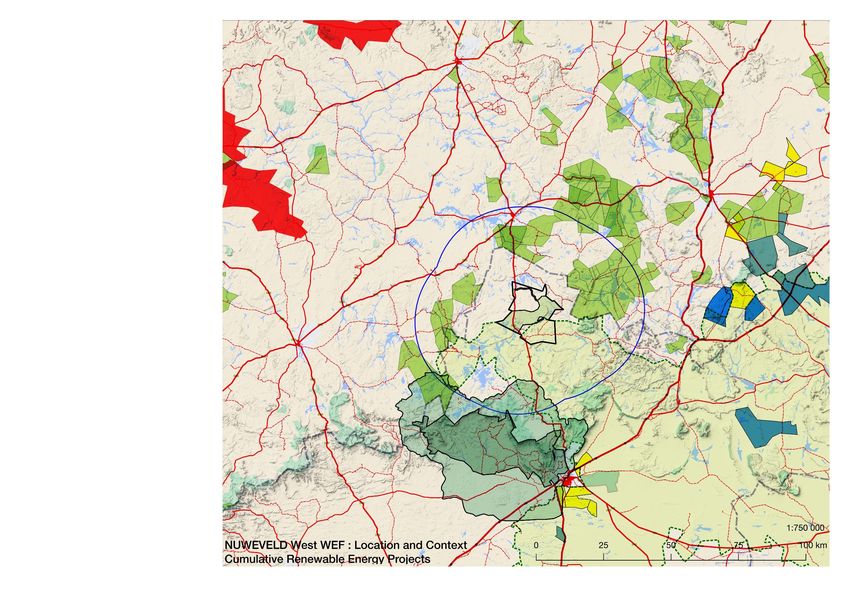
1      PURPOSE AND SCOPE OF THE VISUAL IMPACT ASSESSMENT REPORT
The Visual Impact Assessment (VIA) has been produced as part of an iterative design process followed
during the Visual Screening and Pre-application Scoping Phases of the Nuweveld Wind Farm project.
The intention was to refine the layout for wind turbines and associated infrastructure, taking into
account visual constraints, as well as a number of other specialist studies.
The current preferred layout that has resulted from the earlier Pre-application and Scoping Phases is
what has been assessed in this VIA.
The VIA forms part of the larger Scoping and Environmental Impact Assessment being prepared
by Aurecon, and should be read in conjunction with the larger study for added context, and
particularly the Heritage Impact Assessment (HIA). The location and context of the proposed wind
farm is given on Map 1.

2      VISUAL ASSESSMENT METHODOLOGY
The methodology involves a number of standard procedures including those in the Guideline for
Involving Visual and Aesthetic Specialists (Oberholzer, 2015) and includes:
• A baseline survey of existing scenic resources and visual characteristics of the site, including
   field observations and a photographic survey of visual features and views from sensitive
   receptor locations.
• The identification and mapping of view corridors and important viewpoints to determine the
   visual influence of the proposed WEF.
• The recording of visual issues, where these are known.
• The mapping of zones of visual sensitivity, including buffers, based on best practice criteria.
• The construction of photomontages from selected viewpoints using panoramic photographs
   taken in the field and superimposing a 3D model of the wind turbines.
• The assessment of potential visual impacts relating to the proposed WEF for construction,
   operational and decommissioning phases of the project, and their relative significance.
• The formulation of mitigation measures to avoid or minimise potential negative visual impacts.
• The assessment of cumulative visual impacts in relation to other existing and proposed wind
   energy facilities in the area.
• Impact significance ratings are auto-calculated on a spreadsheet based on a standardised
   methodology provided by Aurecon.

3      SOURCES OF INFORMATION
The main sources of information for the visual assessment included the following:
• Project description data provided by Red Cap and Aurecon (Sept. 2019).
• Chief Directorate: National Geospatial Information 1:50000 Topographic, 1:250000 Topo-
  Cadastral series maps and datasets.
• Council for Geoscience: 1:1000000 Geological Map of South Africa: Spatial Dataset 2011
• Shuttle Radar Topography Mission (SRTM) 1 arcSEC 30m DEM Data 2014
• Google Earth Satellite Imagery 2019
• Google Maps and Open Street Map (OSM) Data 2018
• DEA: Renewable Energy EIA Application Database (REEA) Official Release 2019 Quarter 1
• DEA: South Africa Protected Areas Database (SAPAD) Official Release 2019 Quarter 1
• DEA: South Africa Conservation Areas Database (SACAD) Official Release 2019 Quarter 1
• SANBI: National Freshwater Ecosystem Priority Areas (NFEPA) River and Wetland Datasets
  2017
• SAHRA: National Heritage Sites Inventory Database 2017
• ESKOM: Electricity Grid Infrastructure (EGI) Dataset 2018
• CAA: Civil Aviation Authority: South Africa Airport, Airfields and Obstacle Datasets 2018

Proposed Nuweveld WEF West: Visual Impact Assessment                                                    5
4      SITE INVESTIGATION
A visit to the Nuweveld project site (comprising the Nuweveld North, East and West Wind Farm
areas) and grid corridor, including a photographic survey, was carried out from 30 March to 01
April 2019. The route taken on the field trip is indicated on Map 2. The season was not a
consideration, nor has any major effect for carrying out a visual assessment. Clear visibility was
required for the photographic survey.

5      ASSUMPTIONS AND UNCERTAINTIES
The actual turbine model that may be used has not been determined at this stage, but a range of
sizes (or envelope) has been provided by the Developer, and the worst case, from a visual
perspective has been used in this visual assessment of the turbine envelope (150m hub height and
190m rotor diameter).
Some assumptions had to be made regarding the footprint and height of the proposed substation
(including associated battery facility)and operation and management (O&M) buildings, as well as
lighting and fencing relating to the proposed project as architectural details of these will only
become available at a later stage.

6      REGULATORY FRAMEWORK
The National Environmental Management Act (NEMA) and the Regulations in terms of Chapter 5 of
NEMA (Act No. 107 of 1998), and NEMA EIA Regulations (2014), as amended, apply as the
proposed wind energy facility will trigger a number of listed activities requiring authorization via a
scoping study and EIA process. The need for a visual assessment has been identified as part of this
process.
The National Heritage Resources Act (NHRA) (Act No. 25 of 1999), provides legislative protection
for natural, cultural and scenic resources. This report deals with visual considerations associated
with such resources and sites, while archaeological, paleontological and historical sites are covered
by the heritage specialists.
The 'Guideline for Involving Visual and Aesthetic Specialists' issued by DEA&DP, Provincial
Government of the Western Cape, was followed in the preparation of the VIA.

7      DESCRIPTION OF THE PROPOSED WIND FARM PROJECT
Nuweveld West WEF forms part of 3 proposed wind farms, the others being Nuweveld North and
Nuweveld East, with a capacity of 140-300 MW each. Although a maximum amount of 35 turbines
will be developed for the wind farm, a layout of up to 38 potential turbine positions for Nuweveld
West as indicated on Maps 3 and 4 was considered for this assessment. See Figure 1 below for an
indication of wind turbines at a range of distances. The layout has gone through a number of
iterations during the screening phase and Pre-application Scoping Phase taking the various
specialist studies into account. Following the scoping phase, it is likely that certain turbine positions
will fall away due to further design, environmental or technical constraints that arise along the way.
The WEF would be served by a substation of approximately 150 x 75m, with the proposed site and
connector powerline indicated on Maps 4 and 8. The turbines would be connected by means of
underground and overhead (where needed) powerlines, as well as access / service roads. The
proposed operations and maintenance buildings would be sited adjacent to the substation, (see
Figure 2 below).
An N1 bypass road is proposed to the west and north of Beaufort West for transporting wind turbine
components by means of large abnormal trucks, (see Map 14). After construction of the wind farm
the future use of the road would be decided by the municipality who would determine whether it is
to be rehabilitated by the wind farm or handed over to the municipality.

Proposed Nuweveld WEF West: Visual Impact Assessment                                                   6
The location of temporary construction camps and lay-down areas are indicated on Maps 4
and 8. A detailed description of the WEF facilities is given in Table 1 below.

Figure 1: Indication of wind turbines at a range of distances

Figure 2: Indication of a Typical Substation and Switching Station

Proposed Nuweveld WEF West: Visual Impact Assessment                                 7

Table 1: Nuweveld West WEF Components
 Project               Specifications & Footprint areas                                      Estimated
 Components                                                                                  Combined
 Description                                                                                 Footprint (ha)
 Location              Approximately 65km north of Beaufort West and approximately
                       30km south of Loxton along the R381. Land use of the site and
                       surrounding properties comprise of low density livestock farming
                       (grazing). Total Wind farm area is 12796 ha
 Wind Turbines
                       •  38 potential turbine locations assessed for approval but only
                          up to a maximum of 35 wind turbines will be constructed.
                       • No Turbines are located to the West of the R381.
                       • Turbine envelope:
                         o Rotor diameter: 120m to 190m (up to 95m blade / radius)
                         o Hub height: 80m to 150m
                         o Rotor top tip height: 140m to 245m (maximum based on
                            150m hub + 95m blade = 245m)
                         o Rotor bottom tip height: minimum of 25 m (and not lower).
                       •   Generation capacity: up to maximum of 8MW output per
                           turbine
                       • Nuweveld West has a targeted nameplate capacity of up to a
                           maximum of 280MW.
 Turbine               Each turbine will have a circular foundation with a diameter of up    4.5ha
 Foundations           to 32m and this will be placed alongside the 40m wide hardstand       (permanent)
                       resulting in an area of about 40mx32m that will be permanently
                       disturbed for the turbine foundation.
 Turbine               Each turbine will have a hardstand of 80m x 40m.                      11.2ha
 Hardstands                                                                                  (permanent)
 Cabling               Turbines to be connected to on-site substation via 33kV cables.       1.7ha
                       Cables to be laid underground in trenches mainly adjacent to          (temporary)
                       roads or overhead via 33kV monopoles where burying is not
                       possible due to technical, geological, environmental or
                       topographical constraints. The length of the cabling that is not
                       adjacent to the wind farm roads is 5.8km but of this about 0.3km
                       is running along an existing road thus reducing the impact. The
                       potential area impacted is recorded here for the off-road cables
                       and those sections that run along proposed wind farm roads are
                       covered within the temporary road disturbance footprint, see
                       below.
 Internal WEF          5.3km of 33kV overhead powerline with pylons of up to 20m high.       1.6ha
 overhead              The majority of this (2.9km) will be running next to the proposed     (permanent)
 powerlines            Eskom grid connection ensuring the majority of the internal
                       overhead line impacts are in the same corridor as the proposed
                       grid connection.
 Site roads            Permanent roads will be 6m wide and may require side drains on        ≤54-65ha
                       one or both sides. All roads may have underground cables              (permanent)*
                       running next to them. A 12m wide road corridor may be
                                                                                             ≤46ha
                       temporary impacted during construction and rehabilitated to 6m
                                                                                             (temporary)*
                       wide after construction. For Nuweveld West a total road network
                       of about 76,4km is proposed and the area impacted is presented
                       here. Of this 76,4km, a total of 27km is shared infrastructure with
                       Nuweveld North & East.
 N1 Bypass Road        A temporary bypass road is required on the N1 to avoid the town       6.8ha
 (shared               of Beaufort West with the major Wind Farm components. The             (temporary)
 infrastructure)       road will be up to 6m wide but a 12m wide road corridor may be
                       temporary impacted during construction and rehabilitated once
                       construction is complete. The length of the temporary road will be
                       about 5.6km of which about 2.5km is along an existing track.
 Wind farm             Wind farm will have a 150m x 75m substation yard which
                       includes an Operation and Maintenance (O&M) building,                 3.6ha
 Substations and
                       Substation building and a High Voltage Gantry as well as a 2.4        (permanent)
 battery facility
                       ha area for battery storage facility which may be adjacent or

Proposed Nuweveld WEF West: Visual Impact Assessment                                                          8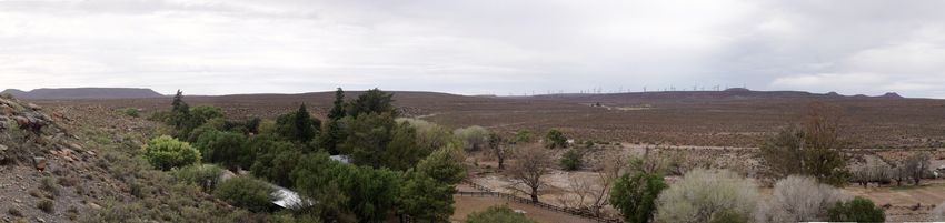
slightly removed from the substation depending on the local
                                constraints. The substation and battery facility will be connected
                                by an underground or overhead cable
 Operations and                 The O&M area will include all offices, stores, workshops, laydown                  Forms part of
 maintenance                    area Building & Substation building will be housed in the                          Substation
 (O&M) area                     substation yard.                                                                   yard
 Security                                                                                                          20m2
                                •    Security gate and hut to be installed at entrance to site.
                                •    No fencing around individual turbines, existing fencing shall
                                     remain around perimeter of properties.
                                •    Temporary and permanent yard areas to be enclosed (with
                                     access control) with an up to 2.4m high fence.
 Temporary                                                                                                         2.2ha
                                •    Wind farm temporary construction areas:
 laydown, staging                                                                                                  (temporary)
 and yards areas                    o Temporary site camp/s areas: 20,000m2
 required for the                   o Batching plant area of approximately 2,000m2
 construction /                     o Each wind farm will have a bunded fuel & lubricants
 decommissioning                      storage facility on site in fixed tanks not exceeding 80m3
 phase.                               (situated at the site camp).
                                •
                          Individual turbine temporary laydown areas including crane
                          boom laydown areas, blade laydown areas and other potential                              17.5ha
                          temporary areas will be up to a maximum of 5000m2.                                       (temporary)
 Total disturbance footprint                                                                                       75ha
                                                                                                                   temporary and
                                                                                                                   86ha
                                                                                                                   permanent*

* these areas represent more than will be impacted given the road values are based on all 38 turbines being constructed wherein reality
only 35 turbines will be developed as part of this application.

Consideration of Alternatives
No alternatives, other than the no-go option, are being considered for the assessment. The
approachhas been to refine the project through iterative inputs from specialists and stakeholders as the
EIA process unfolded, starting with high intensity development (i.e. many turbine positions) and
refining the project until a rationalised layout was achieved in the final application, taking into account
all the social, economic and environmental aspects.

Proposed Nuweveld WEF West: Visual Impact Assessment                                                                                 9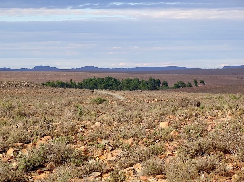
8        DESCRIPTION OF THE STUDY AREA
A brief description of the landscape and scenic features of the site are given below, and in the
accompanying photographs. Maps 3 and 6 provide an indication of the site characteristics.

                                                       Landscape setting
                                                       The site of the proposed Nuweveld West WEF is
                                                       located on the Nuweveld plateau in the Great
                                                       Karoo. The site straddles a flat-topped mesa
                                                       landform with steep side slopes in places. Altitude
                                                       ranges from about 1500m in the plains to the
                                                       northeast, to high points of about 1650m on the
                                                       mesa and koppies in the south.

    Plains and mountains

     Dolerite koppie                                   Geology and landforms
                                                       The landscape in this part of the Great Karoo has
                                                       been eroded over time, the once deeply buried
                                                       Beaufort Group mudstones and sandstones and the
                                                       dolerite intrusions having been exposed to form the
                                                       present-day Karoo landscape.
                                                       The Nuweveld escarpment and plateau is
                                                       characterised by horizontal sills of erosion-resistant
                                                       dolerite forming steep cliffs, boulder-strewn mesas
                                                       or plateaus and flat-topped koppies that are largely
                                                       responsible for the scenic resources of the study
                                                       area.
                                                       The gentler, lower hillslopes and plains consist of
                                                       more easily weathered mudstone, with occasional
                                                       narrow ledges of harder sandstone.

    Vegetation on dolerite koppie                      Vegetation cover
                                                       The vegetation of the Upper Karoo Bioregion is a
                                                       response to the geology and relatively low rainfall,
                                                       which occurs mainly in summer. The Eastern Upper
                                                       Karoo vegetation type covers a vast area on the
                                                       plateau above the escarpment, and consists largely
                                                       of dwarf shrubland, along with grasses and
                                                       succulent shrubs in places.
                                                       The Upper Karoo Hardeveld vegetation type covers
                                                       smaller areas, occuring on the dolerite crests and
                                                       steep slopes, often among large boulders. It
                                                       consists of a grassy dwarf Karoo shrubland.
                                                       (Mucina and Rutherford, 2006).

Proposed Nuweveld WEF West: Visual Impact Assessment                                                         10
Land use
There are no farmsteads on the Nuweveld West
site, while farmsteads surrounding the site are on
average 5 to 10km apart, linked by narrow gravel
roads.
Exotic pines, poplars, beefwoods and gums around
farmsteads in the surrounding areas tend to provide
both shade and visual screening.
Large farms support mainly merino sheep, as well
as dorper sheep, goats, some cattle and game.
Lapfontein
Dorper sheep Sense of place
The flat-topped hills and mesas are a characteristic
feature of the Great Karoo in an otherwise fairly
featureless, parched landscape, an area noted
mainly for its empty, uncluttered landscapes,
stillness, red sunsets, dark nights and starry skies,
as well as for the ancient paleontological remains
hidden in the rocks.
Springbok and many other smaller antelope roam
free on game farms, while the occasional donkey
cart still transports 'Karretjie' people along dirt
roads. Isolated farmsteads in the surroundings form
green oases in the semi-arid landscape, sheltered
from the heat by poplars and other exotic trees.
For the visitor it is an expansive landscape
inhabited by small flocks of sheep, or small antelope
taking fright across the veld.
Proposed Nuweveld WEF West: Visual Impact Assessment 119 VISUAL FEATURES MAPPING
Landscape features of visual or scenic value are described below, along with potential sensitive
receptors in the surroundings. These provide a visual baseline for the study area.
Table 2: Visual Features and Sensitive Receptors
Scenic Resource Landscape features within or adjacent to the development site.
Topographic Characteristic landforms in the Nuweveld include mesas and koppies formed from
features horizontal dolerite sills, such as Skurweberg to the west near the R381. Vertical
dolerite dykes form long knobbly ridges and rock outcrops. These topographic
features contribute to scenic and natural heritage value, providing visual interest or
contrast in the expansive landscape.
Water Features In places dry riverbeds have been carved into the softer mudstones, sometimes
breaking through low ridges. In the dry landscape, drainage features and the larger
dams provide scenic and amenity value.
Cultural Intact wilderness or rural landscapes, contribute to scenic value and sense of place,
landscapes along with green patches of cultivated land and tree copses in alluvial valleys.
Cultural landscapes include archaeological and historical sites identified in the
Heritage Assessment.
Sensitive Receptors adjacent to the site or in the local surroundings.
Receptors
Protected Areas The Karoo National Park, about 25km from the proposed WEF site, includes a
'Viewshed Protection Area'. The Park has wilderness and scenic value in addition to
its biological conservation role.
Private nature Private nature reserves and game farms in the general area, some of which have
reserves, game guest accommodation, are important for the local tourism economy, and tend to be
farms sensitive to loss or degradation of scenic quality.
Human Beaufort West, some 50km south of the site and Loxton about 25km north of the site
settlements, would not be within the zone of visual influence of the proposed WEF. Surrounding
farmsteads farmsteads, particularly those within 10km of the project, may have line of sight and
could be sensitive to the visual intrusion of wind turbines in the landscape. It is
assumed that farms that form part of the development are less visually sensitive.
Scenic routes and The R381 Route between Beaufort West and Loxton, which includes a number of
arterial roads small passes and poorts, has high scenic value in places. This route, and other
district roads, used by residents and visitors to the area, are therefore visually
sensitive.
Cultural and These form part of the heritage study, but could have visual implications.
heritage sites
Proposed Nuweveld WEF West: Visual Impact Assessment 1210 GENERAL GUIDELINES FOR WIND FARMS
Guidelines prepared in the past for buffers around wind energy farms are indicated in Table 3
below. These are, however, intended for regional scale mapping purposes and need to be adapted
at the local scale for individual wind farms. For example, buffers would vary depending on
viewshed mapping, actual site conditions and the design height of wind turbines.
Table 3: Visual Buffers for Wind Turbines
Landscape features PGWC Visual Comment
Guidelines Guidelines
(2006)1 (2018)2
Project area boundary - - Usually 1.5 times height of the proposed turbines.
Prominent topographic 500m 500m Includes prominent ridgelines, peaks and scarp
features edges.
Steep slopes >1:4 >1:4, >1:10 Generally avoid slopes >1:10.
Perennial rivers, large 500m 250 - 500m Subject to specialist freshwater assessment.
dams, wetland features
Provincial / arterial roads 500m 500m - 1 km Could depend on local context, rural / urban.
Scenic routes and passes 2.5 km 1 to 2,5 km Could be less if in a view shadow.
Nature reserves / 2 km 3 to 5 km Could be less if in a view shadow.
protected areas
Private nature reserves/ 500m 1,5 to 3 km Could be less if in a view shadow.
game farms/ guest farms
Farmsteads 400m (noise) 500m General literature recommends 500m to 2 km.
Settlements 800m 2 to 4 km Could be less if in a view shadow.
Cultural landscapes / 500m 500m Subject to heritage assessments.
heritage sites
1
Provincial Government of the Western Cape, (PGWC) 2006. Recommended Criteria Thresholds for Regional and Site
Level Assessment, prepared by CNdV.
2
CSIR, 2018. SEA for Wind and Solar Photovoltaic Energy in SA, Phase 2. Visual and Scenic Resources Chapter
prepared by B. Oberholzer and Q. Lawson.
11 VISUAL SENSITIVITY MAPPING
Scenic resources and sensitive receptors within the study area have been categorised into no-go,
high sensitivity, medium sensitivity and low visual sensitivity zones, as indicated in Tables 4 to 7
below. The visual sensitivity mapping categories for wind turbines, buildings and substations
(including associated battery facility), internal roads and internal overhead powerlines are indicated
on Maps 7 to 10, and the N1 Bypass on Map 14.
The visual sensitivity mapping, which is intended to guide the layout of wind turbines, buildings,
substations (including associated battery facility) and access roads, was partly informed by the
guidelines in Table 3 above, and by adapting these to local site features. The sensitivity mapping
provides some indication of the level of acceptable change in visual terms.
Proposed Nuweveld WEF West: Visual Impact Assessment 13Table 4: Visual Sensitivity Mapping Categories for Wind Turbines (See Map 7)
Scenic Resources No-go areas High visual Medium visual Low visual Neutral
sensitivity sensitivity sensitivity
Topographic features, ridges, Feature Within 250m - - -
peaks, scarps
Minor ridges, scarps, outcrops Feature - Within 250m
Steep slopes Slopes > 1:4 Slopes > 1:10 - - -
Scenic water features Feature Within 150m - - -
Cultural landscapes1 Feature Within 250m - - -
Protected Landscapes / Sensitive Receptors
National Parks (Karoo NP) n/a n/a n/a - -
Nature Reserves n/a n/a n/a - -
Private reserves / game farms Feature within 3 km within 5 km - -
Settlements / towns n/a n/a n/a - -
Farmsteads outside site within 500m within 1km within 2km - -
Farmsteads inside site within 500m within 750m within 1km
Arterial route R381 within 250m within 500m within 750m - -
Scenic Passes/ Poorts (R381) within 500m within 750m within 1 km - -
Main district road within 150m within 250m within 500m - -
Scenic district road within 250m within 500m within 750m
Notes:
1
Cultural Landscapes are the areas defined by the heritage specialists around important cultural feature/s as presented
in the heritage report
Buffers could be less if receptors are in a view shadow.
Table 5: Visual Sensitivity Mapping Categories for Buildings and Substations (including associated
battery facility) (See Map 8)
Scenic Resources No-go areas High visual Medium visual Low visual Neutral
sensitivity sensitivity sensitivity
Topographic features, ridges, Feature Within 150m - - -
peaks, scarps
Minor topo / Geolog features Feature Within 100m - - -
Steep slopes Slopes > 1:4 Slopes > 1:10 - - -
Scenic water features Feature Within 100m - - -
Cultural landscapes1 Feature Within 150m - - -
Protected Landscapes / Sensitive Receptors
National Parks (Karoo NP) n/a n/a n/a - -
Nature Reserves n/a n/a n/a - -
Private reserves / game farms Feature within 500m within 1 km - -
Farmsteads outside within 250m within 500m Within 750m - -
farmsteads inside within 150m within 250m within 500m - -
Scenic routes / Poorts within 250m within 500m within 750m - -
Arterial route R381 within 150m within 250m within 500m - -
Main district road within 100m within 150m within 250m - -
Scenic district road within 150m within 250m within 500m - -
1
Cultural Landscapes are the areas defined by the heritage specialists around important cultural feature/s as presented
in the heritage report
Proposed Nuweveld WEF West: Visual Impact Assessment 14Table 6: Visual sensitivity mapping categories for internal overhead powerlines (See Map 9)
Scenic Resources No-go areas High visual Medium visual Low visual Neutral
sensitivity sensitivity sensitivity
Topographic features, ridges, Feature - - - -
peaks, scarps
Minor topo / outcrops Feature - - - -
Steep slopes Slopes > 1:4 Slopes > 1:10 - -
Scenic water features Feature Within 50m - - -
Cultural landscapes1 (Rock Art Area as defined Within 50m
only) by the heritage
specialist
Cultural landscapes1 (all other, -2 Within 50m - - -
excluding Rock Art)
Protected Landscapes / Sensitive Receptors
National Parks n/a n/a n/a - -
Nature Reserves n/a n/a n/a - -
Private reserves / game farms n/a n/a n/a - -
Farmsteads outside n/a n/a n/a - -
farmsteads inside Feature Within 50m - -
Scenic routes / Poorts Feature Within 50m - - -
Arterial route R381 Feature Within 50m - - -
Main district road - - - - -
1
Cultural Landscapes are the areas defined by the heritage specialists around important cultural feature/s as presented
in the heritage report.
2
No Go areas that are more relevant to visual impacts have been defined in these cultural landscapes and thus preclude
development within them where it will be visually unacceptable. These are captured and mapped under the scenic
resources above such as "topographic features, ridges, peaks, scarps", "scenic water features", "farmsteads", "scenic
routes" etc.
Exception to No-Go areas would apply where internal overhead power lines ascend/descend scarps at right angles. The
lines should follow valleys and avoid peaks/ridges where possible. The final route of internal lines needs to be reviewed
by the specialist/s.
≤ 5km total powerline in No-Go areas associated with topographic features, ridges, peaks and scarp
Table 7: Visual sensitivity mapping categories for internal access roads (See Map 10)
Scenic Resources No-go areas High visual Medium visual Low visual Neutral
sensitivity sensitivity sensitivity
Topographic features, ridges, Feature - - - -
peaks, scarps
Geolog features / outcrops Feature - - - -
Steep slopes Slopes > 1:4 Slopes > 1:10 - - -
Scenic water features Feature Within 50m - - -
Cultural landscapes1 (Rock Art Area as defined Within 50m - - -
only) by the heritage
specialist
Cultural landscapes1 (all other, -2 Within 50m
excluding Rock Art)
Protected Landscapes / Sensitive Receptors
National Parks(Karoo NP) n/a n/a n/a - -
Nature Reserves n/a n/a n/a - -
Private reserves / game farms n/a n/a n/a - -
Farmsteads outside n/a n/a n/a - -
farmsteads inside Feature Within 50m Within 100m - -
Scenic routes / Poorts - Within 100m Within 150m - -
Arterial route R381 - - - - -
Main district road - - - - -
1
Cultural Landscapes are the areas defined by the heritage specialists around important cultural feature/s as presented
in the heritage report.
2
No Go areas that are more relevant to visual impacts have been defined in these cultural landscapes and thus preclude
development within them where it will be visually unacceptable. These are captured and mapped under the scenic
resources above such as "topographic features, ridges, peaks, scarps", "scenic water features", "farmsteads", "scenic
routes" etc.
Proposed Nuweveld WEF West: Visual Impact Assessment 15Notes: Existing roads utilised by the wind farm may go through no-go areas
Table 8: Visual sensitivity mapping categories for N1 Bypass Route (See Map 14)
Scenic Resources No-go areas High visual Medium visual Low visual Neutral
sensitivity sensitivity sensitivity
Topographic features, ridges, Feature - - - -
peaks, scarps
Geology features / outcrops Feature - - - -
Steep slopes Slopes > 1:4 Slopes > 1:10 - - -
Scenic water features Feature Within 50m - - -
Cultural landscapes1 (Rock Art Area as defined Within 50m
only) by the heritage
specialist
Cultural landscapes1 (all other, -2 Within 50m - - -
excluding Rock Art)
Protected Landscapes / Sensitive Receptors
National Parks (Karoo NP) Within 50m Within 100m Within 150m - -
Nature Reserves n/a n/a n/a - -
Private reserves / game farms n/a n/a n/a - -
Towns, Settlements Feature Within 100m Within 150m
Farmsteads Feature Within 50m Within 100m - -
1
Cultural Landscapes are the areas defined by the heritage specialists around important cultural feature/s as presented
in the heritage report.
2
No Go areas that are more relevant to visual impacts have been defined in these cultural landscapes and thus preclude
development within them where it will be visually unacceptable. These are captured and mapped under the scenic
resources above such as "topographic features, ridges, peaks, scarps", "scenic water features", "farmsteads", "scenic
routes" etc.
12 POTENTIAL VISUAL IMPACTS
Potential visual impacts arise where turbine positions conflict with identified scenic resources and
sensitive receptors as indicated on the Visual Sensitivity maps.
Scenic resources within the site include the prominent topographic and water features described in
Section 6 above.
Sensitive receptors include game farms, especially those with tourism facilities, as well as
individual farmsteads within the site and in the surroundings.
Arterial and main district routes are visual corridors from which the Karoo landscape is mainly
experienced by both inhabitants and visitors to the area. Scenic portions along these routes have
increased visual sensitivity.
Potential visual impacts associated with the proposed project are included in Tables 11 to 17.
13 VISUAL IMPACT CRITERIA
The visual assessment of the proposed WEF is based on a number of quantitative and qualitative
criteria to determine potential visual impacts, as well as their relative significance, including the
considerations described below.
13.1 Visual Exposure
A viewshed of the proposed WEF is indicated on Map 5 being the potential zone of visual influence
of the development based on the 38 turbine layout (representing a theoretical Worst Case
Scenario). The white areas on the maps are in a view shadow and therefore not visually affected
by the proposed WEF. Visual exposure is fairly evenly spread around the proposed WEF up to
about 25km distance, but less to the east owing to the screening effect of the topography.
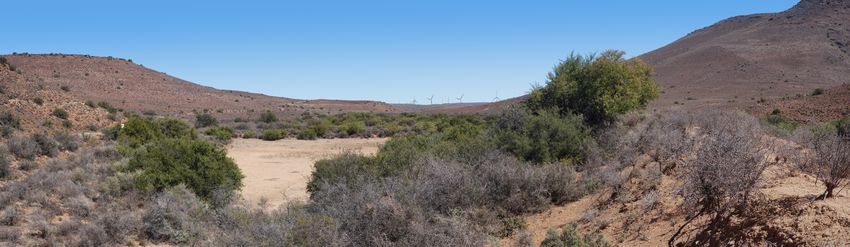
Proposed Nuweveld WEF West: Visual Impact Assessment 1613.2 Visibility A number of significant viewpoints have been identified, together with their relative distances and anticipated visibility of the proposed WEF in Table 9 below. The viewpoints were selected based on proximity to the WEF and the potential sensitivity of identified receptors, including users of arterial routes along with guest farms and farmsteads. The colours used in the table merely indicate levels of visibility related to distance, and do not imply significance. Degrees of visibility would depend on the number of turbines in the view field and their position in the landscape (e.g. on ridgelines), as well as on foreground screening provided by topography or trees. Potential visibility of the Nuweveld West WEF is indicated below based on the photomontages in Figures 3-5. See also Figure 1 for a comparison of visibility of turbines at various distances. High visibility: Prominent feature within the observer’s viewframe 5km Mod-high visibility: Relatively prominent within observer’s viewframe 5-10km Moderate visibility: Clearly visible as part of the wider landscape 10-15km Marginal visibility: A minor element in the landscape on the horizon 15-25km Proposed Nuweveld WEF West: Visual Impact Assessment 17
Table 9: Viewpoints and Distances to Proposed Nuweveld WEST WEF (march 2020 layout)
 View    Location                               Coordinates   Distance     Turbine    Visibility
 point                                                        to WEF       Nº
 vp19    Gansfontein farmstead, local road      31.756639S    2.90 km      146        High visibility
                                                22.546324E
 vp18    Bultfontein farmstead, local road      31.807493S    3.19 km      145        High visibility
                                                22.524124E
 vp16    Lapfontein farmstead, local road       31.877673S    12.20 km     108        Moderate to high visibility
                                                22.328307E
 vp15    Onrus farmstead, local road            31.768099S    9.99 km      72         Moderate to high visibility
                                                22.328545E
 vp14    Sterkfontein farmstead, local road     31.800328S    11.78 km     72         Moderate visibility
                                                22.298547E
 vp20    Abramskraal farmstead, local road      31.774248S    11.65 km     146        Moderate visibility
                                                22.648114E
 vp24    Spitskop                               31.928172S    12.10 km     126        Moderate visibility
                                                22.508806E
 vp21    Booiskraal farmstead, district road    31.862664S    12.25 km     137        Moderate visibility
                                                22.595347E
 vp2     Dunedin farmstead, R381 Route          31.948333S    13.11 km     126        Moderate visibility
                                                22.420511E
 vp17    Driefontein farmstead, local road      31.885400S    17.22 km     72         Marginal visibility
                                                22.263994E
 vp6     Ramfontein farmstead                   31.627358S    14.12 km     99         Not visible
                                                22.437464E
 vp5     Quaggasfontein farmstead, local road   31.622123S    14.76 km     100        Marginal visibility,
                                                22.522873E                            farmstead in view shadow
 vp8     Bulskolk, district road                31.711041S    15.50 km     72         Moderate visibility
                                                22.299667E
 vp13    Inverurie farmstead, Vosfontein        31.813486S    17.74 km     72         Marginal visibility
                                                22.235707E
 vp9     Elandsfontein, district road           31.752165S    18.37 km     72         Marginal visibility
                                                22.240337E
 vp10    Game Lodge, Donkergat farm             31.765835S    18.91 km     72         Not visible
                                                22.229413E
 vp3     Duikerfontein, R381 Route              31.616486S    18.22 km     98         Marginal visibility,
                                                22.354032E                            farmstead in view shadow
 vp23    Hillcrest farmstead, district road     31.902754S    20.66 km     137        Marginal visibility
                                                22.670903E
 vp11    Roodepoort farmstead, district road    31.783018S    22.02 km     72         Not visible
                                                22.192425E
 vp1     Rosedene farmstead, R381 Route         32.031948S    22.02 km     126        Not visible
                                                22.438670E
 vp4     Spes Bona farmstead, district road     31.571790S    21.62 km     100        Marginal visibility
                                                22.572980E
 vp22    Hazeldene farmstead, district road     31.906636S    21.21 km     146        Not visible
                                                22.687984E
 vp12    Sakrivierspoort farmstead              31.819500S    27.02 km     72         Marginal visibility, mainly in
                                                22.137149E                            view shadow
         Other Farms within 30km

         Eyerkuil                               31.917490S      17.81 km        126   Marginal visibility
                                                22.284970E
         Rosary                                 31.945560S      18.55 km        126   Marginal visibility
                                                22.299966E
         Midlands                               31.651314S      15.64 km         98   Marginal visibility
                                                22.352134E
         Melrose                                31.931343S      18.42 km        133   Marginal visibility
                                                22.610531E
         Willemskraal                           31.948610S      19.33 km        132   Not visible
                                                22.600501E
         Vlakfontein / Leeufontein              31.729680S      19.98 km        146   Not visible
                                                22.729947E
         Springfontein                          31.733277S      25.30 km         72   Not visible
                                                22.194996E
         Dundee                                 32.005927S      22.77 km        126   Marginal visibility
                                                22.576023E
         Uitspansfontein                        32.050547S      29.06 km        126   Marginal visibility
                                                22.275712E

Proposed Nuweveld WEF West: Visual Impact Assessment                                                            18
13.3 Visual Absorption Capacity (VAC)
This relates to the potential of the landscape to screen the proposed WEF from view. Wind turbines
tend to be more obscured from view in broken mountainous topography and more exposed in the
open plains. Turbines located on ridgelines or koppies tend to be more visible in the landscape,
particularly when seen in silhouette. The sparse Karoo vegetation provides little screening effect.
However dense clumps of trees around farmsteads tend to reduce visibility by receptors.
13.4 Landscape Integrity
Landscape integrity tends to be enhanced by scenic or rural quality and intactness of the landscape,
as well as absence of other visual intrusions. Natural or pristine landscapes tend to have higher
visual quality and therefore higher value. Cultural landscapes, such as rural or farming scenes also
have visual or scenic value. On the other hand, industrial activity and visual 'clutter', including
substations and power lines, detract from these scenes. Most of the site for the proposed WEF has
an uncluttered, expansive landscape with wilderness or pastoral scenes, for which the Karoo is
renowned.
13.5 Visually Sensitive Resources
Natural and cultural landscapes, or scenic resources, form part of the 'National Estate' and may have
local, regional or even national significance, usually, but not only, of tourism importance. Within the
WEF study area, the dolerite dykes, koppies and other outcrops tend to be the main features of scenic
and geological interest.
13.6 Visual Impact Intensity
The overall potential visual impact intensity is determined in Table 9 below by combining all the
factors above, namely visual exposure, visibility, visual absorption capacity, landscape integrity and
visually sensitive resources. Visual impact intensity is in turn used to assess overall visual impact
significance of the proposed WEF and related infrastructure, such as the substation (including
associated battery facility), buildings, internal overhead powerlines and access roads.
Table 10: Visual Impact Intensity
Visual Criteria Comments Wind turbines Related
infrastructure
Visual exposure Extensive viewshed relating to the large scale and High Low
number of wind turbines.
Visibility Visible from parts of the R381 Route, main district roads, High Low
and a number of farmsteads.
Visual absorption Visually exposed plain and ridges (in places). High Medium
capacity
Landscape integrity / Effect on rural farming character and Karoo landscape. High Medium
intactness
Landscape / scenic Effect on scenic resources / dolerite outcrops. High Low
sensitivity
Impact intensity Summary High Medium-low
Proposed Nuweveld WEF West: Visual Impact Assessment 1914 VISUAL IMPACT ASSESSMENT The quantification of visual impacts for the proposed Nuweveld West WEF is based on the methodology provided by Aurecon (2019), described below. The assessment criteria are included in Appendix A of this report. Status (positive or negative type impact): The status of the visual impact, is considered to be negative, given the height and large number of wind turbines, in relation to the landscape character and scenic resources of the area, along with a number of visually sensitive receptors. Extent (spatial scale): The zone of visual influence would be approximately 25km radius from the WEF. The assigned value would therefore be municipal area for turbines and local for smaller infrastructure. Duration (temporal scale): The predicted life-span of the proposed wind farm and related infrastructure is expected to be more than 15 years, and therefore the assigned numerical value is on-going. The construction phase would be short-term. Intensity (magnitude or degree of alteration): Based on the potential visual impacts outlined in Table 8 above it is expected that the intensity of the impacts would range from high for the proposed wind turbines to medium-low for the related infrastructure. Consequence: Consequence is calculated as a combination of intensity + extent + duration in conjunction with status. Probability (likelihood): The likelihood of the potential visual impacts occurring is certain (without mitigation) given the scale of the proposed WEF and the exposed nature of the terrain, with little opportunity for screening or mitigation. Significance: Significance is determined by combining consequence with probability, firstly without mitigation and then with mitigation measures in place. The level of significance is calculated automatically in the spreadsheets provided by Aurecon, (Tables 10 to 15). Confidence: The confidence rating for the visual impact findings is high based on the precedent of similar wind farms in the region, and on the photomontages prepared for the current proposals. Reversibility: The potential visual impacts would only be reversible over the long term if the wind farm and related infrastructure were decommissioned and the site rehabilitated. However, it is likely that these facilities will be needed to increase the capacity of the electrical infrastructure for some time into the future. The assigned rating is therefore given as medium. Proposed Nuweveld WEF West: Visual Impact Assessment 20
Table 11: Visual Impact Assessment: Construction Phase – Wind Turbines

Proposed Nuweveld WEF West: Visual Impact Assessment                     21
Table 12: Visual Impact Assessment: Construction Phase – Infrastructure

Proposed Nuweveld WEF West: Visual Impact Assessment                      22
Table 13: Visual Impact Assessment: Operation Phase – Wind Farm

Table 14: Visual Impact Assessment: Operation Phase - Infrastructure

Proposed Nuweveld WEF West: Visual Impact Assessment                   23
Table 15: Visual Impact Assessment: Operation Phase - Lighting

Table 16: Visual Impact Assessment: Operation Phase – N1 Bypass Road

Proposed Nuweveld WEF West: Visual Impact Assessment                   24
Table 17: Visual Impact Assessment: Decommissioning Phase

14.1   Visual Assessment of Alternatives
No alternatives for the wind farm site and layout, other than the No-Go option, have been assessed
in the Specialist Scoping and EIA Reports, as alternatives were screened out of the project in the
early Screening Phase, and the layout was further refined in the Pre-application Scoping Phase.
As it is not possible to easily mitigate the visual impact of wind turbines by means of visual screening,
it is important that mitigation is employed through avoidance. This has largely been achieved by the
iterative design process during the Screening and Pre-application Scoping Phases, where no-go
and high visual sensitivity areas have been avoided. In particular, turbines previously located to the
west of the R381 Route, as well as a number of 'outlier' turbines have been removed in the latest
preferred layout, which has significantly helped to minimise visual impacts.
Micro-siting of the proposed turbine locations and infrastructure may be effected as the project
progresses, and will result in a final preferred layout that minimises negative impacts, as far as
possible.

14.2   Visual Assessment of the No-go Alternative
The no-go alternative would mean that there would be no additional visual intrusion on the rural
landscape and on settlements in the area by wind turbines and related infrastructure. Scenic features
and the overall sense of place would therefore remain intact and foreseeable replacement land uses
carry little risk for significant visual impact. The downside is that no renewable energy would be
produced.
It is envisaged that the potential visual impact significance of the no-go alternative would be neutral as
the status quo would likely continue and there would be no further visual impacts.

Proposed Nuweveld WEF West: Visual Impact Assessment                                                   25
14.3   Cumulative Visual Impacts
Cumulative visual impacts have considered all renewable energy land uses within 30km of the
proposed project site. Currently, the only projects located within this zone are the other proposed
Nuweveld wind farms, namely North and East. This cumulative impact is therefore the combined
impact of the Nuweveld North, West and East Wind Farms, as well as the 132/400kV grid connection
to Beaufort West.
The development of the proposed three Nuweveld wind farms and associated grid connection, when
seen together, would result in cumulative visual impacts resulting in a change to the largely rural
character and sense of place of the area, (see Map 12).
The cumulative visual impact significance could potentially be moderate to major for the three
proposed wind farms and associated grid connection, given the potential effect on the rural
landscape and Karoo's sense of place.
However, currently, the cumulative impact assessment has been based on all the potential turbine
positions associated with the proposed WEFs (i.e. 113 in total), while only 35 turbines per WEF
would likely be developed (i.e. 105 in total), which may offset some of the cumulative visual impact.
In addition, the nature of the topography would result in some screening between the wind farms,
and these would therefore seldom be seen fully in combination.

14.4   Future Possible Wind Farm Development in the Area
Based on available information, there are no further wind farms currently proposed in the general
area, within 30km of the proposed Nuweveld project.
On the question whether the landscape can absorb additional visual impacts from future wind farms,
this will depend partly on the terrain, which varies from visually exposed open plains (to the
northwest), and more broken mountainous terrain (to the southeast), which has more visual
absorption capacity.
The number of wind turbines is a further consideration, as large numbers can easily result in pastoral
landscapes becoming industrialised. Therefore, fewer large turbines tend to be preferable to
numerous smaller turbines resulting in visual 'clutter' in the landscape. Small wind farms such as
those at Darling and Caledon in the Western Cape, are more easily absorbed into the landscape.
Opinions vary on whether wind farms should be clustered together to concentrate the visual impacts,
or whether they should be dispersed more than 30km apart. The majority of the Nuweveld Wind
Farm area falls within the REDZ11 proposed to form part of the Renewable Energy Development
Zones (REDZs) (Map 1). The concept of REDZs tends to suggest that wind farms should be
grouped in zones that have been identified as being suitable for wind farm development. Care needs
to be taken, however, to avoid visual impacts on regional scenic resources, such as the Nuweveld
mountain escarpment, particularly where scenic mountain passes exist.
Therefore, absorption capacity for further wind energy developments in the Nuweveld area could
potentially exist, but the visual threshold would be determined by the nature of the local terrain and the
scale of future proposed developments and is therefore difficult to quantify at this stage.

15     VISUAL MITIGATION MEASURES
Mitigation measures are recommended for the siting of wind turbines and the development of
related infrastructure in order to minimise visual impacts on scenic resources and sensitive
receptors. Some mitigation, through avoidance, has already been achieved during the screening
phase, which consisted of a number of layout iterations taking into account visual informants. The
visual mitigations are included in Tables 11 to 17 above.

Proposed Nuweveld WEF West: Visual Impact Assessment                                                   26
16      ENVIRONMENTAL MANAGEMENT PROGRAMME
Visual input into the Environmental Management Programme (EMPr) is discussed below. This
should be included in the Environmental Authorisation for the project.

16.1    Construction Phase Monitoring:
Ensure that visual management measures are included as part of the EMPr, monitored by an
Environmental Control Officer (ECO), including siting of any construction camps and stockpiles (see
mitigation measures in Section 16 above), dust suppression and litter control measures.
Responsibility: ECO / Contractor.
Timeframe: Preparation of EMPr during the planning phase. Monitoring during the contract phase.

16.2    Operation Phase Monitoring:
Ensure that visual mitigation measures are monitored by management on an on-going basis, including
the maintenance of rehabilitated areas, as well as control of any signage, lighting and wastes at the
proposed wind farm, with interim inspections by a delegated ECO.
Responsibility: Wind farm operator and ECO.
Timeframe: During the operational life of the project.

16.3 Decommissioning Phase Monitoring:
Ensure that procedures for the removal wind turbines and building structures during
decommissioning are implemented, including recycling of materials and rehabilitation of the site to
a visually acceptable standard, and signed off by the delegated authority.
It is assumed that some access roads and concrete pads would remain. Those that are not required
should be ripped and the vegetation or grazing cover reinstated.
The revegetation measures are not described here as they would fall under the auspices of the
vegetation/biodiversity specialist.
Responsibility: ECO / Contractor / qualified rehabilitation ecologist or horticulturist.
Timeframe: During the decommissioning contract phase, as well as a prescribed maintenance period
thereafter (usually one year).

17      CONCLUSION AND RECOMMENDATIONS
The layout of the Nuweveld West WEF followed an iterative planning process during the Screening and
Pre-application Scoping Phases, and takes into account the various specialist aspects, including scenic
resources. The proposed layout succeeds in avoiding visual 'no-go' areas indicated on the visual sensitivity
maps. Further refinement of the layout may be possible if some of the turbine locations are not required.
The proposed wind farm and related infrastructure, such as the substation (including associated
battery facility), could affect the rural quality, or sense of place, of the general area, particularly when
combined with the proposed Nuweveld North and East wind farms. There are no other known wind
farms planned within 30km of the Nuweveld WEF project.
Using the assessment methodology provided by the EAP (Aurecon, 2019), potential visual impacts
were automatically calculated in a spreadsheet. The visual impact significance of the proposed wind
farm and related infrastructure is summarized in Table 18 below.

Wind Turbines
Mitigation in the form of avoidance has already taken place through the various iterations in the
siting of the wind turbines. Further limited mitigation is possible by means of omitting or micro-siting
some of the wind turbines. The potential visual impact significance during the operational phase was
Proposed Nuweveld WEF West: Visual Impact Assessment                                                     27
calculated to be major (negative) before mitigation, and would remain major (negative) after
mitigation (see Table 13).
Although avoidance mitigations have been implemented as part of the design process, the overall
visual effect of the 3 wind farms and the associated grid line would still result in a change in character
to the rural Karoo landscape, which was taken into account.
The methodology used in the spreadsheet only provides a range of 4 categories of significance,
being negligible, minor, moderate and major, while a more nuanced range could result in a
'moderate-major' significance after mitigation. However, the worst-case scenario remains major.

Substation (including associated battery facility) and Buildings
Potential visual impact of the substation (including associated battery facility) and O&M buildings
has been minimized through siting of these in a low visual sensitivity area away from scenic
resources and sensitive receptors (see Map 8), as currently planned. Further limited mitigation is
possible by means of screening with vegetated berms and planting if necessary. The potential visual
impact significance was calculated to be moderate (negative), before mitigation and minor
(negative) after mitigation (see Table 14).

Internal Overhead Powerlines and Access Roads
Most internal powerlines would be constructed underground, while others, such as those crossing
drainage lines and steep areas, would need to be overhead. Internal access roads would make use
of existing roads and tracks where possible, but a large number of new access roads would be
required. The potential visual impact significance was calculated to be moderate (negative), before
mitigation and minor (negative) after mitigation, (see Table 14).

N1 Bypass Road
The proposed temporary bypass road around Beaufort West town for the transport of wind farm
components would result in some visual and noise impacts on adjacent residential development, the
golf course and the Karoo National Park, resulting in a moderate (negative) visual impact significance
before mitigation, and minor (negative) significance after mitigation, including rehabilitation. (See
Table 16).

Conclusion
Given the relatively large number and large scale of the wind turbines, the potential visual impact of
the wind farm was calculated to be major (-), before mitigation. However, some scope for mitigation
is possible in the siting of the wind turbines, and treatment of the related infrastructure. In addition,
the VIA considered the visual impact of 45 turbines, but only 35 turbines will be constructed,
potentially reducing the visual impact, depending on which turbines are constructed and which fall
away. This assessment, however, considers the worst-case scenario in terms of the visual impact
associated with the Nuweveld West WEF.
If the wind farm is approved and the final layout does not need all approved turbine locations to
ensure a maximum of 35 turbines, then where a choice exists between turbines to be dropped, and
all other factors are equal, priority should be given to dropping turbines in the 'high' visual sensitivity
areas as indicated on Map 7. Given the scale and extent of the proposed wind farm, the exclusion
of turbines in these areas is unlikely to change the overall significance ratings, and is therefore seen
as an optional mitigation.
Potential cumulative visual impact of the three proposed Nuweveld wind farms (including associated
battery facility), seen in combination, could be major (-), but taking into consideration that there are
no other existing or proposed wind farms within 30km, the cumulative visual significance is more
likely to be moderate (-).

Proposed Nuweveld WEF West: Visual Impact Assessment                                                    28
You can also read