FRONTIERS OF THE ROMAN EMPIRE (ANTONINE WALL) WORLD HERITAGE SITE
                                SUPPLEMENTARY PLANNING GUIDANCE
                                          ENVIRONMENTAL REPORT
←
→
Page content transcription
If your browser does not render page correctly, please read the page content below
FRONTIERS OF THE ROMAN EMPIRE (ANTONINE WALL) WORLD HERITAGE SITE
SUPPLEMENTARY PLANNING GUIDANCE
ENVIRONMENTAL REPORT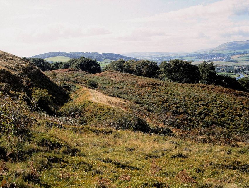
© All images Crown Copyright reproduced courtesy of Historic Scotland
                            www.historicscotlandimages.gov.uk

Front cover: The pits, known as lilia, to the north of the fort at Rough Castle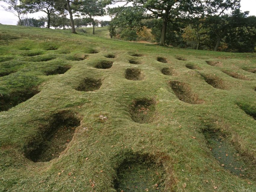
1.      Non technical summary…………………………………………….…………….…….                                                                    2
1.1          Introduction……………………………………………………………….…………………….……..                                                             2
1.2          What is SEA?................................................................................................   2
1.3          Context…………………………………………………………………………………………….……...                                                               3
1.4          Assessment of the environmental effects of the guidance…….……………......                                          3
1.5          Mitigation measures……………………………………………………..……………..………….                                                          4
1.6          Monitoring……………………………………………………………….….............................                                              4
1.7          Consultation…………………………………………………………….………………………………                                                               4

2.      Introduction…………………………………………………………………………….……                                                                        5
2.1          Background……………………………………………………………………………………..……..                                                               5
2.2          Content of the draft guidance………………………………….………………….….………                                                       8
2.3          The SEA process……………………………………………………….………………..……….…..                                                           8

3.      Environmental objectives and scope of assessment……………..……...                                                        9
3.1          Other plans, programmes and environmental objectives…………….………....                                              9
3.2          Scoping the environmental topics to be included in the assessment……....                                        12

4.      Environmental baseline, problems and evolution…………………………                                                            15
4.1          Environmental baseline……………………………………..….……………………………….                                                          15
4.2          Environmental issues………………………………………..………………………………..….                                                          20
4.3          Evolution of the environment without the guidance…….……………..…………                                                23

5.      Assessment approach and methods……………………….………………….….                                                                 24
5.1          Scoping the level of detail of the assessment……………………….…………….……                                                24
5.2          How was the draft guidance assessed?.......................................................                    24

6.      Assessment findings……………………………………………..……………………....                                                                  26
6.1          Assessment of broad alternatives………………………………..…………………………..                                                     26
6.2          Assessment of alternatives within the guidance……………………………….………                                                 27
6.3          Assessment findings – key principles………………………..………………………………                                                    30
6.3.1        Historic Environment………………………………………..………..……………………….……                                                         30
6.3.2        Landscape……………………………………………………..………..………………………….……                                                              30
6.3.3        Population and human health…………………………..………………………………………                                                         32
6.3.4        Soil……………………………………………………………..……………..……………………….…….                                                              32
6.4          Cumulative and synergistic effects………………………………………………….………..                                                    32
6.5          Appropriate Assessment……………………………………..……………………………………                                                           33

7.      Monitoring and Mitigation……………………………………..……………………..                                                                 34
7.1          Monitoring……………………………………………………………………………………….……….                                                               34
7.2          Recommendations……………………………………..…………….……………………...………                                                            35

8.      Next Steps………………………………………………………………………………..…….                                                                       36

                                                                                                                                 1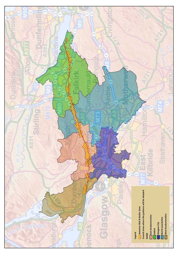
1. Non‐Technical Summary
1.1 Introduction
As part of the preparation of the Frontiers of the Roman Empire (Antonine Wall) World
Heritage Site Supplementary Planning Guidance, North Lanarkshire Council is carrying out a
Strategic Environmental Assessment (SEA). The SEA considers the likely environmental
effects of implementing the guidance. The guidance supports the delivery of development
plan policies agreed by the five Councils along the Antonine Wall: Falkirk, North Lanarkshire,
East Dunbartonshire, Glasgow City Council and West Dunbartonshire. Background
information can be found in section 2.
The information set out in this report is based on the assessment of the likely environmental
effects of implementing the guidance. Our findings have informed the preparation of the
guidance and will be taken into account prior to being finalised and formally adopted.
1.2 What is Strategic Environmental Assessment?
SEA is a systematic method for considering the likely environmental effects of certain plans,
programmes and strategies (PPS). SEA aims to:
integrate environmental factors into PPS preparation and decision‐making
improve PPS and enhance environmental protection
increase public participation in decision making
facilitate openness and transparency of decision‐making
SEA is required by the Environmental Assessment (Scotland) Act 2005. The key SEA stages
are:
Screening: determining whether the PPS is likely to have significant
environmental effects and whether an SEA is required.
Scoping: deciding on the scope and level of detail of the Environmental
Report and the consultation period for the report – this is done in
consultation with Scottish Natural Heritage, Historic Scotland and
the Scottish Environment Protection Agency.
Environmental publishing an Environmental Report on the PPS and its
Report: environmental effects, and consulting on that report.
Adoption: providing information on: the adopted PPS; how consultation
comments have been taken into account; and methods for
2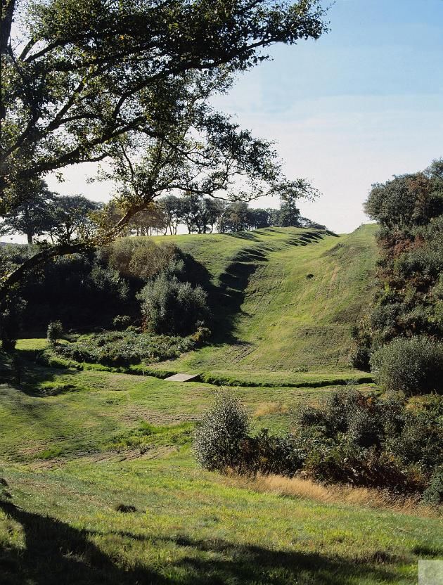
monitoring the significant environmental effects arising form its
                      implementation.

Monitoring:           monitoring significant environmental effects in such a manner so
                      as to also enable the Responsible Authority to identify any
                      unforeseen adverse effects at an early stage and undertake
                      appropriate remedial action.

The assessment process is structured around SEA topic areas. These topic areas are the range
of environmental issues which should be explored through the assessment. They include
biodiversity, flora and fauna, population and human health, water, soil, air, climate, material
assets, cultural heritage and landscape.

1.3 Context

One of the early stages of the SEA process is to consider the relationship of the guidance to
other relevant policies, plans, strategies and environmental objectives. This allows key
environmental issues to be identified for consideration during the process of preparing the
guidance. It is also important to identify the plans and strategies that will influence the
guidance and those that will be influenced by the guidance. Table 2 sets out the review of
the legislation, policies, plans and strategies that are considered to be of most direct
relevance to the draft guidance.

To help consider the environmental effects of the draft guidance information about relevant
aspects of the environmental baseline was gathered. Because the guidance provides advice
relating to sections of the Antonine Wall across the width of Scotland, a baseline
incorporating aspects of the five relevant Local Authorities was established. This included
information on landscape, historic environment, soil, human health and population as the
topics considered likely to be affected by the guidance. Section 4 of the report summarises
the environmental baseline.

1.4 Assessment of the environmental effects of the guidance

A framework has been used to help predict the environmental effects of the guidance. This is
shown in table 4 and allows questions to be asked whilst stepping through the requirements
of SEA. This approach helped to make the assessment systematic and consistent.

It was found that the guidance has the potential to result in significantly positive effects for
the historic environment and landscape. There may also be minor positive effects for
population and human health and soil. No negative effects (individually or cumulatively) were
identified through the assessment. The detailed results of the assessment are described in
section 6 of the report.

                                                                                                3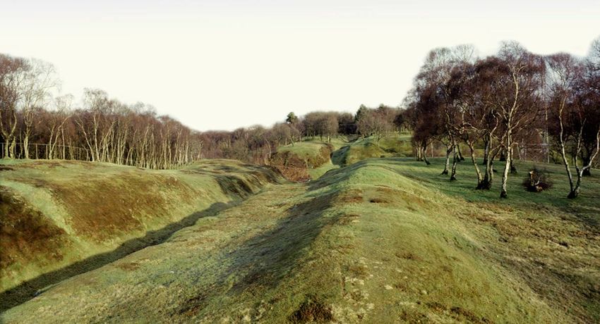
1.5 Mitigation Measures

No significant negative effects were predicted during the course of the assessment which
would require specific mitigation measures. However it was possible to make a number of
recommendations to further improve the clarity and coverage of the guidance to enhance the
positive effects. These recommendations are explained in section 6 of the report.

1.6 Monitoring

Although no significant negative effects are predicted it will be important to ensure that it is
understood how the guidance is affecting the environment once it is being implemented. As
such ways to monitor the effects of the guidance have been suggested in section 7 of the
report.

1.7 Consultation

This Environmental Report accompanies the draft guidance for six weeks of public
consultation from 20 June 2011 to 5 August 2011. Any comments that you would like to
make on either documents are welcomed. With regards to the Environmental Report the
main questions to consider is:

 Do you agree with the results of the environmental assessment and have the
 key issues associated with implementing the guidance been identified?

                                                                                                   4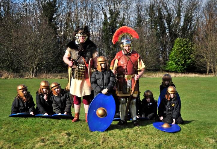
2. Introduction
2.1 Background
As part of the preparation of the Frontiers of the Roman Empire (Antonine Wall) World
Heritage Site Supplementary Planning Guidance, North Lanarkshire Council is carrying out a
Strategic Environmental Assessment (SEA). SEA is a systematic method for considering the
likely environmental effects of certain plans, programmes and strategies (PPS). SEA aims to:
integrate environmental factors into PPS preparation and decision‐making;
improve PPS and enhance environmental protection;
increase public participation in decision making; and
facilitate openness and transparency of decision‐making.
The information set out in this report is based on the assessment of the draft guidance. The
findings of this assessment have influenced the preparation of the guidance and will go on to
inform the final document. SEA is required by the Environmental Assessment (Scotland) Act
2005. The key stages are:
Screening determining whether the PPS is likely to have significant
environmental effects and whether an SEA is required
Scoping deciding on the scope and level of detail of the Environmental
Report, and the consultation period for the report – this is done in
consultation with Scottish Natural Heritage, Historic Scotland and
the Scottish Environment Protection Agency
Environmental publishing an Environmental Report on the PPS and its
Report Environmental effects, and consulting on that report
Adoption providing information on: the adopted PPS; how consultation
comments have been taken into account; and methods for
monitoring the significant environmental effects of the
implementation of the PPS
Monitoring monitoring significant environmental effects in such a manner so
as to also enable the Responsible Authority to identify any
unforeseen adverse effects at an early stage and undertake
appropriate remedial action
5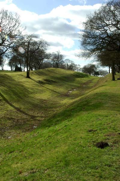
The purpose of this Environmental Report is to:
provide information on the content of the guidance;
identify, describe and evaluate the likely significant effects of the guidance and its
reasonable alternatives; and
provide an early and effective opportunity for the public, and Consultation Authorities to
offer views on any aspect of the relevant documents.
The key facts relating to the guidance are set out in Table 1 below.
Table 1: Key facts
Responsible Authority: North Lanarkshire Council
Title of guidance: Frontiers of the Roman Empire (Antonine Wall) World Heritage Site
Supplementary Planning Guidance
What prompted the Commitment set out in the Antonine Wall World Heritage Site
guidance: Management Plan 2007‐12
Subject: Planning, historic environment
Period covered by Undefined
guidance:
Frequency of updates: As required
Area covered by Antonine Wall World Heritage Site and Buffer Zone which includes Falkirk,
guidance: North Lanarkshire, East Dunbartonshire, Glasgow City Council, and West
Dunbartonshire
Purpose and/or To help ensure that development along the wall retains, protects and
objectives of guidance: preserves the Outstanding Universal Value of the monument and its
setting. In particular, it seeks to:
explain the significance of the Antonine Wall and its status as a
World Heritage Site
encourage early and effective consultation with Councils and
Historic Scotland
outline the approach and procedure for assessing development
affecting the World Heritage Site
set out the criteria which will be applied in determining planning
applications for development along the line and within the setting
of the World Heritage Site
guide decisions on planning appeals and enforcement
Contact Name: Lyndsay Noble
Job Title: Senior Planning Officer
Contact Address: Fleming House
2 Tryst Road
Cumbernauld
G67 1JW
Contact Tel: 01236 616 242
Contact Email: NobleLy@northlan.gov.uk
6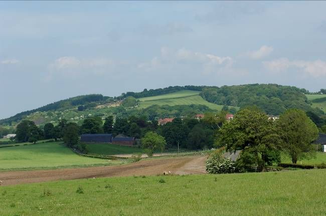
Figure 1: Antonine Wall World Heritage Site and Buffer Zone Location map

7
    Reproduced by permission of Ordnance Survey on behalf of HMSO. (c) Crown copyright and database right [2011]. All rights reserved. Ordnance Survey Licence number 100017509
2.2 Content of the draft guidance
The purpose of the guidance is to:
explain the significance of the Antonine Wall and its status as a World Heritage Site
encourage early and effective consultation with Councils and Historic Scotland
outline the approach and procedure for assessing development affecting the World
Heritage Site
set out the criteria which will be applied in determining planning applications for
development along the line and within the setting of the World Heritage Site
guide decisions on planning appeals and enforcement
2.3 The SEA process
The requirement for SEA comes from the Environment Assessment (Scotland) Act 2005. The
purpose of SEA is to ensure that information on the environmental effects of a plan,
programme or strategy is gathered and made available to plan‐makers and decision takers as
the plan is prepared and implemented. The overarching aim of SEA is to promote sustainable
development. Under section 5(3) of the Act, plans, programmes and strategies with the
potential to have significant environmental effects are to be subject to environmental
assessment prior to adoption. As is the case here, certain types of guidance can also qualify
for and require SEA.
The guidance will be adopted by five local authorities and Historic Scotland. In this situation
however, one Responsible Authority needs to be identified and in this case it is North
Lanarkshire Council. As North Lanarkshire Council, with agreement of all parties, considered
that the guidance has the potential to result in significant environmental effects they
submitted a Scoping Report to the Scottish Government’s SEA Gateway on 3 July 2009 to seek
the views of the relevant Consultation Authorities (SNH and SEPA). SNH and SEPA agreed that
the guidance is likely to have significant environmental effects for all SEA topics and helpful
comments were received from both organisations who were generally supportive of our
proposed approach.
During the assessment some changes were made to the scope of the assessment to better
reflect the purpose of the guidance. Further details on the scoping process can be found in
Section 3.2. Following on from the scoping stage, an environmental assessment of the draft
guidance was carried out as it was being developed. This report presents the results of that
environmental assessment, sets out the measures proposed to mitigate/enhance certain
elements of the guidance and suggests indicators to monitor its effects. This report
accompanies the draft guidance for a six week period of public consultation from 20 June
2011 to 5 August 2011.
Once the consultation period is complete, the need for changes to the guidance will be
reviewed. Where significant changes are made which could result in significant
environmental effects, an assessment will be undertaken of their effect, and reported in the
SEA Post Adoption Statement. This will be published along with the final guidance.
83. Environmental Objectives and Scope of Assessment
3.1 Other plans, programmes and environmental objective
One of the early stages of the SEA process is to consider the relationship of the guidance to
other relevant policies, plans and strategies. This allows key environmental protection
objectives to be identified for consideration during the preparation process. It is also
important to identify both the plans, programmes, strategies and environmental objectives
that will influence and those that will be influenced by the guidance itself. An understanding
of the context and the hierarchy that the guidance sits within is useful for giving early thought
to any required mitigation measures and where they may be best implemented.
We have not published our full review of relevant plans, programmes and strategies; instead,
Table 2 sets out our review of those that are considered to be most directly relevant to the
guidance. It has been assumed that the key environmental objectives for each of the
environmental topics identified in Schedule 3 of the Act are translated into national policy
and strategy. The environmental protection framework provided by European legislation has
not been reviewed in detail. Instead, the focus has been to review the key areas of legislation
and policy relevant to the guidance and its assessment.
9Table 2: Legislative/Policy context for the guidance
SEA Topic Summary of Environmental Objectives Plan, Programme or Strategy
Biodiversity, Biodiversity policies from international to local levels aim in particular to Council Directive 79/409/EEC on the conservation of wild birds
Flora and conserve habitats, species and ecosystems. Halting the decline of key Council 92/43/EEC the conservation of natural habitats and of wild
Fauna species is important, and where possible remedial action and fauna and flora
enhancement should be implemented in degraded areas. Policies also Wildlife and Countryside Act 1981
note the importance of an ecosystem approach – an holistic, landscape Conservation (Natural habitats &c.) Amendment (Scotland)
approach to biodiversity conservation that goes beyond the traditional Regulations 2007
emphasis on protecting individual sites. Nature Conservation (Scotland) Act 2007
UK Biodiversity Action Plan
Scotland’s Biodiversity – It’s In Your Hands.
Population Policy outlines the need to seek to improve health and quality of life. Improving Health in Scotland – the Challenge
and Human
Health
Soil Policies on soil seek to protect resources from a range of impacts, Scottish Soil Framework (2009)
including soil sealing by development, increased susceptibility to erosion
and soil pollution.
Water Water related policies aim to protect water resources, and achieve an Water Framework Directive 2000/60/EC
improvement in their ecological condition where appropriate. River Basin Water Environment and Water Services (Scotland) Act 2003 (WEWS)
Management Plans, which were prepared under the Water Framework Act
Directive and WEWS Act set specific objectives for the protection and Scotland River Basin Management Plan (2009)
improvement of water resources within each river basin.
Air Air quality targets have been set at the European and UK levels. The Air 2008/50/EC Directive on ambient air quality and cleaner air for
Quality Strategy for England, Scotland, Wales and Northern Ireland sets Europe
objectives for Particulate Matter (PM), oxides of nitrogen (NOx), sulphur The Air Quality Strategy for England, Scotland, Wales and Northern
dioxide (SO2) and ozone (O3) amongst others. Good progress is being Ireland (2007)
made towards meeting them.
10SEA Topic Summary of Environmental Objectives Plan, Programme or Strategy
Climatic Policies focus on the need to cut greenhouse gas emissions. National UK Climate Change Act 2008
factors targets are for an 80% reduction by 2050 making a contribution to climate Climate Change (Scotland) Act 2009
change abatement targets set at the UK, EU and international levels. Climate Change Delivery Plan (2009)
Energy policy highlights the importance of energy efficiency, and the need Climate Change Adaptation Framework (2009)
to achieve a shift from fossil fuels to renewable sources of energy. In UK Low Carbon Transition Plan (2009)
addition the importance of adequate, planned adaptation to future Conserve and Save: Consultation on the Energy Efficiency Action Plan
climates is noted in order to increase the resilience of communities, and (2009)
natural and economic systems.
Cultural Historic environment policies aim to identify and protect historic buildings Scottish Historic Environment Policy (SHEP) 2009
heritage and sites from inappropriate development and damage. Policies extend Scottish Planning Policy (SPP)
beyond specific designated sites to reflect the value of wider townscapes, Managing Change in the Historic Environment Guidance Notes
the setting of monuments and historic buildings, and wider cultural FRE (Antonine Wall) WHS Management Plan
landscapes. Convention Concerning the Protection of the World Cultural and
Natural Heritage (1972)
Landscape Landscape policies aim to not only safeguard protected areas, but to Council of Europe, European Landscape Convention (2000)
recognise and conserve wider landscapes. These may not be formally SNH Landscape Policy Framework
designated but make an important contribution to the quality of SNH Wildness in Scotland’s countryside
environment. SNH Natural Heritage Futures
SNH National Scenic Areas Programme
Material Agricultural and forestry policies promote sustainable land use, Scottish Forestry Strategy
assets environmental protection and stewardship, and emphasise the Strategic Transport Review Project
importance of delivering public goods out with market mechanisms. National Transport Plan
Policy sets a target of increasing forest cover to 25% of land cover. The Local Housing Strategy
planning system highlights the need to allow the development of high Scottish Planning Policy
quality, well designed, energy efficient housing. Efficient design will A Vision for Scottish Agriculture
contribute to climate change abatement targets, as will transport The Zero Waste Plan for Scotland
emission reductions.
11In addition to those plans outlined in table 2, the most relevant planning document is the
Local development Plan (adopted or in preparation) for each Council, all of which contain
relevant policies for land use and its responsible management.
The key environmental objectives identified from the review of legislation, policies, plans and
strategies are:
To protect and where appropriate enhance the historic environment ‐ specifically,
protecting the archaeological remains, the line and the setting of the Antonine Wall (an
ancient monument of international importance)
To halt the loss of biodiversity and continue to reverse previous losses through targeted
action for species and habitats
To protect and enhance species and habitats
To increase awareness, understanding and enjoyment of the natural and historic
environment
To protect and enhance the water environment (with a requirement to ensure that the
status of all waters are protected from deterioration)
To promote and encourage opportunities for people of all abilities to enjoy access to
wildlife and the countryside
To manage access appropriately to avoid damage to archaeological sites or habitats, and
disturbance to wildlife, especially breeding birds, by heavy public use of sensitive areas
To protect, enhance and, where appropriate, restore landscape character, local
distinctiveness and scenic value
To protect soil resources and promote soil function
To reduce the exposure of sensitive receptors to poor air quality
To promote sustainable development
To reduce our contribution to climate change and be positioned to respond to the
predicted effects of climate change
3.2 Scoping the environmental topics to be included in the assessment
A key part of the SEA process is identifying the environmental parameters (from Schedule 3 of
the Act) that are likely to be affected by the guidance. This can lead to some environmental
topics being “scoped out” of the assessment and helps to focus the SEA on the key
environmental issues. A Scoping Report was prepared in July 2009 which set out the
proposed scope and level of detail of the assessment and comments were sought from The
Consultation Authorities.
At the outset, and at the time of scoping, it was anticipated that the guidance would have a
role in delivering other environmental objectives and this was reflected in the scoping in of all
topics identified in Schedule 3 of the SEA Act. However, as work on the guidance and its
environmental assessment has progressed over the past year it has become clear that for the
guidance to be an effective planning tool, focusing on the protection of the World Heritage
Site’s Outstanding Universal Value, the opportunity for the incorporation of other
environmental objectives is limited. Likewise, the potential for the guidance to negatively
12impact upon other interests is also limited. The focus of the guidance is about helping key
stakeholders understand the policies by providing criteria that will assist with decision
making. The key role of this criteria is to focus upon heritage matters and is not intended to
outweigh or supersede other material considerations or policies, particularly those outlined in
each Council’s local development plan.
Therefore, while we initially scoped all SEA topics into the assessment, in light of the current
focus of the guidance, we subsequently reviewed the scope to better reflect the alternatives
that could be reasonably considered and delivered.
While we have considered environmental effects in relation to all environmental topics we
consider that the areas where significant effects are now most likely relate to cultural
heritage, landscape, soil and population and human health (access). Table 3 provides our
rationale for those environmental topics that we have scoped out of the assessment.
13Table 3: Scoping in/out
Environmental Scoped Potential issues arising from the guidance and justification for scoping in/out
parameter in/out
Biodiversity, Flora Out Although there may be some indirect effects for biodiversity, flora and fauna as a result of protecting the OUV the
and Fauna guidance will focus on the type and quality of new development on and around the Antonine Wall. It will not contain
guidance on other environmental parameters which is outlined elsewhere in national policy and guidance. As such we
have scoped this topic out of the assessment.
Population and In The guidance could have effects on population and human health through the provision of protection for a site of
Human Health cultural and educational interest.
Soil In There may be effects for soil as a result of guidance on forestry or agriculture activities. This will depend on the
advice included in the guidance but we have taken the precautionary approach of scoping the topic in to the
assessment.
Water Out The advice in the guidance will not address water quality, flow, flooding or pollution. As such we have scoped this
topic out of the assessment.
Air Out It is considered that the guidance will not have significant effects on air. The advice in the guidance is unlikely to
significantly improve air quality or lead to higher levels of pollution. As such we have scoped this topic out of the
assessment.
Climatic Factors Out It is considered unlikely that the implementation of the guidance will contribute to the causes of climate change or to
its mitigation. As such we have scoped this topic out of the assessment.
Material Assets Out Although the guidance may affect forestry and agricultural activities the relevant environmental effects are
considered to be those to soil as they will cover future activity rather than current assets. These effects have been
considered under the soil topic and material assets scoped out.
Cultural Heritage In The main purpose of the guidance is to provide for the protection of the Outstanding Universal Value. For this reason
it is expected that the guidance will have significantly positive effects for the historic environment.
Landscape In Some of the Antonine Wall is designated for its natural landscape value and some areas are currently rural and open.
The guidance will be addressing the appropriate scale and land use of developments within these sites and it is
therefore considered that it could also significantly effect landscapes.
144. Environmental Baseline, Problems and Evolution
4.1 Environmental Baseline
In order to establish the environmental effects of the draft guidance it is necessary to
understand the environmental baseline of the area that is likely to be affected. As noted
above, Schedule 3 of the Act lists the environmental parameters that should be considered in
SEA. To focus the SEA, baseline information has been gathered on the environmental issues
that are likely to be affected by the guidance. For that reason information has not been
gathered on those environmental parameters scoped out of the assessment (table 3 sets out
the environmental topics that are scoped in/out of the assessment).
Given that the guidance will be implemented all along the line of the Antonine Wall, baseline
information has been gathered for each of the five local authorities containing a section. We
have not published all the detailed baseline information gathered during our assessment,
however, a summary of the key baseline information for each environmental topic scoped
into the assessment is set out below.
Population and human health
The environment provides a variety of
services that are beneficial to human
health including opportunities for
education and recreation. Access to
historic environment sites, forests,
woodlands and nature conservation
sites as well as the wider environment
can help to promote healthier
lifestyles having positive effects on
both physical and mental health.
The Antonine Wall is therefore an
important resource for education,
School children visit the Antonine Wall, March 2009
recreation and tourism, allowing
visitors to experience and understand the site first hand.
The quality of the environment in which we live can also impact on our quality of life. High
quality urban environments, including natural landscapes can create a sense of place,
influencing well being. For these values to be retained the Antonine Wall needs to be
managed in a sustainable way to ensure that the positive and distinctive contribution it can
make to our landscape, sense of history and identity, sense of place and well being can be
realised. While the key delivery tool for promotion of the Antonine Wall is the (FRE) World
Heritage Site Management Plan, the guidance should help to deliver, and not hinder,
opportunities for education and recreation.
15The FRE (AW) WHS and buffer zone 1 is typically close to fairly densely populated areas.
Recently, the area close to the Antonine Wall in North Lanarkshire has experienced change
through recent releases of housing land. This has resulted in some significant population
increases at Croy, Gartcosh and Dullatur. Unemployment is below the Scottish average in
Falkirk and East Dunbartonshire, but with higher than average levels in North Lanarkshire,
Glasgow and West Dunbartonshire. This trend is reflected for the local authorities in lower
average life expectancy, and higher levels of poor health and multiple deprivation.
Historic Environment
Scotland has five 2 World Heritage Sites, over 47,000 listed buildings and more than 600
conservation areas. 386 sites are currently identified in the Inventory of Gardens and
Designed Landscapes. The actual extent of archaeological remains in Scotland is unknown
with 8,151 Scheduled Monuments representing only a small proportion of the archaeological
sites for which the Royal Commission on the Ancient and Historical Monuments of Scotland
(RCAHMS) holds records and the many more unrecorded sites and unknown resources
throughout the country.
Designation helps to protect important aspects of
our cultural and historic environment by ensuring
that they are considered in the management of
change introduced by development. It is important
that consideration goes beyond the designated
buildings and sites to reflect the value of wider
townscapes, the setting of historic resources and
wider cultural landscapes, including the Antonine
Wall.
In July 2008, the international cultural and
archaeological importance of the Antonine Wall was
recognised when the World Heritage Committee of
UNESCO 3 inscribed the site as Scotland’s fifth World
Heritage Site (WHS). The Antonine Wall then
became an extension of the trans‐national Frontiers
of the Roman Empire World Heritage Site (FREWHS)
which already includes Hadrian’s Wall in England and General view of the wall at Seabegs fort
the Upper Raetian German Limes. The intention is that the WHS will eventually include all
surviving sections of the frontiers of the Romans in Europe, Africa and the Middle East.
1
The buffer zone along the Antonine Wall has been defined in relation to local circumstances, including the
landscape and modern features such as towns and villages, roads and railways. The aim, as with all buffer zones,
is to protect the setting of the monument and, in this case, continue to allow understanding of why the Antonine
Wall was erected in a particular location.
2
New Lanark, Edinburgh Old and New Towns, St Kilda, The Heart of Neolithic Orkney, The Frontiers of the
Roman Empire (Antonine Wall)
3
United Nations Educational, Scientific and Cultural Organisation
16The Antonine Wall is of great significance for a number of reasons. It represents one of many
sections of a massive military system which stretched over 5000 km from northern Britain,
through Europe to the Black Sea, and from there to the Red Sea and across North Africa to the
Atlantic coast. This frontier helped to protect – and define – the Roman Empire, one of the
greatest states ever to have existed. The Antonine Wall was the most northerly frontier of
the Empire, the last of a series of planned frontiers built in the 2nd Century AD and, at the
time, the most complex ever constructed by the Romans.
The Antonine Wall runs through the northern part of North Lanarkshire, from Castlecary in
the east to Croy Hill in the west. This is one of the most visible sections of the Wall, as it
passes along the south side of the Kelvin valley and over the hills. As a result, the Wall has a
particularly strong presence in the surrounding area. Other features of interest include the
Forth and Clyde Canal, colliery pits and a foundry. There are numerous listed buildings,
including a number within the buffer zones of the Antonine Wall.
The parts of the Antonine Wall in Falkirk include the best surviving stretches of the rampart,
ditch, outer mound and Military Way, the best surviving fort and annexe earthworks, some
visible remains of the stone‐walled fort at Castle Cary (the only visible fortlet). The area also
includes nine Conservation Areas and numerous listed buildings, many of which are within the
WHS buffer zones.
The rampart and ditch of the Antonine Wall at Rough Castle looking east
Within East Dunbartonshire the Antonine Wall and the Roman Bathhouse in Bearsden are
two of the most important Roman relics. The best evidence of the wall can be seen at New
Kilpatrick Cemetery, Bearsden, where the stone base is clearly visible. The ditch to the north
of the rampart can be seen to best effect at Bar Hill, Twechar. The Antonine Wall buffer zone
includes listed buildings, conservation areas and townscape protection areas.
17The Antonine Wall can be found in two locations in Glasgow to the northern edge of the City
boundary at Summerston and Drumchapel. Other sites of importance include the Forth and
Clyde Canal. West Dunbartonshire contains the western terminus of the Antonine Wall. The
area of the wall within West Dunbartonshire runs from Cleddans Burn in the east, to
Duntocher and ends in Old Kilpatrick at the Gavinburn Roman fort. Other sites of importance
include the Forth and Clyde Canal.
With World Heritage Site status comes a commitment to protect the exceptional cultural
significance of the Antonine Wall and Outstanding Universal Values (OUV) for which the site
was inscribed. It is imperative that development does not compromise the values for which
the Antonine Wall was inscribed as a World Heritage Site, nor its authenticity or integrity.
New development is a key threat to the cultural heritage resource.
The Military Way would have run the entire length of the wall. It was normally about 5.5m wide and
placed about 50m south of the wall. It rarely survives as a visible feature, but can be seen here at
Bar Hill, Twechar.
18Soil
Soils are an important natural asset on which life depends. They perform a wide range of
essential environmental, social and economic functions, such as growing food, controlling the
quality and quantity of water flow, and storing carbon 4. Scottish soils are distinguished by
their high organic content, water content and leached character 5. Soil also protect
archaeological remains and provides a record within it of previous cultivation and
improvement and, therefore, of the historical development of landscapes and societies 6.
Within Falkirk the soil resource varies from higher quality agricultural land in the valley
lowlands to the poorer soils of the more elevated areas. For example, the large rural area of
the Slamannan plateau and smaller outliers around Denny, to the north at Airth and east of
Polmont, support a largely open agricultural landscape. To the west, the soils are typically of
lower quality for agriculture. There is a high percentage of agricultural land considered to be
of high quality with land capability for agriculture classes 2 to 4 (wide to narrow ranges of
crops) occurring throughout the lower lying areas of the Forth estuary and Carron Valley.
All of the local authority areas have a long history of industrial activity. Each have a legacy of
vacant, derelict and contaminated land to varying degrees. Trends in the quantities of vacant
and derelict land are uncertain, as there have been recent phases of re‐development.
Development pressure (including agricultural land management, forestry and industrial
operations) is identified as the key threat to soils.
Barr Hill overlooks the Kelvin Valley and its farmland. The Roman fort lies on the summit of the hill.
46
, The State of Scotland’s Soils, SEPA Report (2011): www.sepa.org.uk/land/soil.aspx
5
Scottish Soil Framework: www.scotland.gov.uk/Publications/2009/05/20145602/13
19Landscape
Scotland has a rich variety of landscapes, not limited to places where there has been no
development. More than one million hectares are designated as National Scenic Areas,
reflecting areas of the highest landscape value and National and Regional Parks afford
protection to scenic areas of national and regional importance, respectively. Landscapes are
dynamic, shaped by the interaction of natural processes and human activities. They can be
strongly influenced by built development and land management. The pace and scale of
landscape change has increased with technological progress.
Landscapes are a key part of our cultural heritage having huge economic potential and are a
vital part of our sense of place and general well‐being. Scottish Planning Policy requires
consideration of development impacts on landscapes and emphasises the importance of a
sympathetic approach. Consideration should be given to landscapes outwith designated
areas and should be managed to safeguard
and enhance their distinct identity.
Designated areas should be managed in
such ways that are consistent with
safeguarding their scenic value.
The Antonine Wall stretches from the
coastal landscape at Bo’ness through the
broad valleys and agricultural farmland, to
Glasgow and West Dunbartonshire. Three
Areas of Great Landscape Value (AGLV)
cover the surrounding upland and valley
landscapes of the Antonine Wall within
Falkirk council area.
Pressures on the landscape include
insensitive development, development
pressure in the urban fringe (particularly
Falkirk and North Lanarkshire) and wide
scale visual effects such as windfarms.
General views of Rough Castle fort on the Antonine Wall
20Gaps and or unreliability of the Environmental Baseline data
The following summarises the gaps and/or unreliability of the SEA baseline data, and how
they were minimised:
The Antonine Wall and buffer zone is a specific linear feature which occupies a small area of
land within each local authority area. The environmental baseline information available
across the SEA topic areas is typically produced at a local authority level, and therefore
wider trends have had to be extrapolated as relevant to Antonine Wall and buffer zone.
There is a lack of information on landscape trends and the implications of climate change
on the landscape and townscape, or historic environment. SNH is currently undertaking
research to explore the landscape implications of climate change.
There is limited information on local amenity, which can be extrapolated to some extent
from the results of open space audits, which reflect the quality of open spaces. However
although open space audits are underway or completed in the local authorities in question
the results of the analysis are not widely available.
4.2 Environmental Issues
The purpose of this section is to explain how existing environmental problems will affect or be
affected by the guidance and whether it is likely to aggravate, reduce or otherwise affect
existing environmental problems.
Environmental problems that affect the guidance were identified through an initial analysis of
the baseline environmental data for the Antonine Wall and buffer zone. The key issues for
the area are:
High levels of deprivation and poor health in some areas
Areas of vacant, derelict and contaminated land
Some decline in quality of historic environment
Pressures on landscape and townscape from new development, including renewable
energy
These environmental problems and their implications for the guidance are summarised in
table 4.
21Table 4. Environmental problems relevant to the guidance
Topic Problem Supporting data (where available) Implications for Guidance
Population High levels of Census & SIMD data The guidance should ensure that
and human deprivation and GROS Statistics access and interpretation to the
health poor health in Falkirk Community Health Profile Antonine Wall is not inhibited,
some areas. East Dunbartonshire Local Plan State of the particularly in more deprived
Environment report 2008 areas.
North Glasgow Community Health Profile.
A Community Health and Wellbeing Profile for
West Dunbartonshire.
Glasgow Centre for Population Health, 2008.
Soil Areas of vacant, Vacant and Derelict Land Register The guidance should allow for
derelict and SEPAs State of the Environment Report (and not inhibit) remediation of
contaminated East Dunbartonshire Local Plan State of the vacant, derelict and
land. Environment report 2008 contaminated land where this
Glasgow City Plan SEA meets the objectives of
The State of Scotland’s Soils (SEPA Report, 2011) protecting the Outstanding
Universal Value.
Cultural Some decline in Falkirk Council Sustainable Falkirk indicators 2004 The guidance should support the
heritage quality of historic Falkirk Local Plan SEA, Structure Plan Report of protection and enhancement of
environment Survey the historic environment
resources. North Lanarkshire State of the Environment report resources by identifying the
East Dunbartonshire Local Plan State of the areas for protection and
Environment Report 2008 identifying a series of key
Glasgow City Plan SEA principles.
West Dunbartonshire Local Plan Environmental
Report 2008
Landscape, Pressures on North Lanarkshire State of the Environment The guidance should ensure that
townscape landscape and Report the impacts of new development
and townscape from East Dunbartonshire Local Plan State of the on landscape, townscape and
amenity new development, Environment Report 2008 amenity are minimised by
including Local plans identifying important features in
renewable energy. relation to the Antonine Wall,
and criteria for assessing impacts
on these features.
224.3 Evolution of the environment without the guidance
Without the Supplementary Planning Guidance, planning applications for development in and
around the World Heritage Site would continue to be determined according to the policies of
the existing Development Plan. While such an approach is expected to mitigate any
significant negative effects upon the Antonine Wall, there is potential for inconsistency in
both the interpretation and application of the policies. This is one of the key reasons why
there is a consistent protection policy that will apply (once adopted) to all Council areas. The
absence of this guidance may also result in a reduced awareness that the Antonine Wall
forms part of a wider international designation.
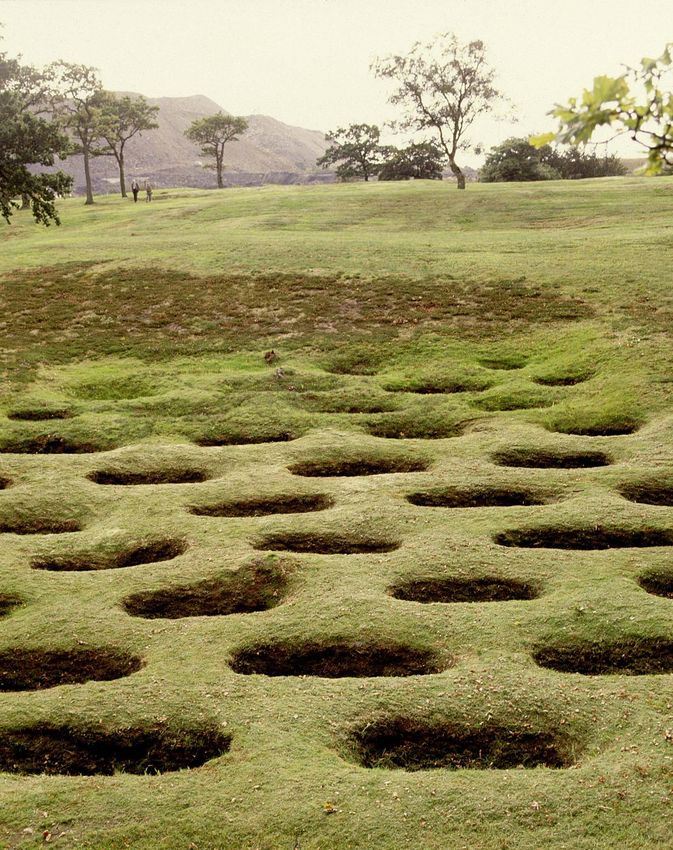
The pits, known as lilia, to the north of the fort at Rough Castle
235. Assessment Approach and Methods
5.1 Scoping the level of detail for the assessment
It is important for any environmental assessment to be undertaken at an appropriate level of
detail. In reaching a view on the level of detail it is necessary to understand the place of the
guidance in the overall hierarchy of management and protection for the historic environment.
We hope that its content will influence the decisions taken on individual planning applications
for developments along the Antonine Wall and its Buffer Zone. The guidance may also
influence other public land use policies such as those for forestry. As the format of the
guidance was still being developed and has been influenced by the SEA we did not include
detailed information on its likely content in this scoping report. We now know that the
guidance will contain a list of factors (key principles) to consider in relation to a development
proposal and examples/criteria of what could be considered to result in adverse effects and
how to mitigate (avoid) harm (and where possible enhance positives). Given the SEA is about
understanding and testing the likely significant effects of implementing the guidance the
following elements were identified as being the key areas to consider:
Section 3: Assessing the impact of development
Section 4: Design and mitigating impacts
Other aspects of the guidance, such as the background information to the inscription of the
site and procedural matters (e.g. the need for scheduled monument consent in some
circumstances) have not been assessed as these will have no or minimal environmental
effects.
5.2 How was the draft guidance assessed?
We adopted a two stage approach to the assessment. Firstly, we considered the way in which
the guidance could be prepared. This looked at the overall approach of implementing the
commitment set out in the overarching policy. The findings of this are set out in section 6.1.
Secondly, we assessed alternative ways of implementing the guidance in terms of how we
explain the overarching policy for the protection of the (FRE) Antonine Wall WHS and its
Buffer Zone. As noted above, we consider this to be the sections relating to assessing the
impact of development (3) and design and mitigating impacts (4). We therefore tested the
key principles contained in each of these sections. At scoping stage an assessment framework
was developed to provide a consistent way of assessing the draft guidance. Given the revised
scope of the assessment and based on an initial analysis of the environmental issues relevant
to the guidance we reviewed our approach.
24We took the view that the assessment should focus on four key questions. They are:
Historic Environment: Will the principles provide for protection of the Outstanding
Universal Value of the site?
Landscape: Will the principles help to protect and enhance landscape character and scenic
value?
Population and Human Health: Will the principles promote access to the cultural and
natural environment for recreation or education?
Soil: Will the principles provide for the protection of soil resources (and function)?
These questions formed the foundations for our approach to the assessment which looked
thematically at the guidance reflecting the SEA environmental topic areas. Table 4 below sets
out the framework we used in our assessment. This structure allows these questions to be
asked whilst stepping through the requirements of SEA.
Table 4: Assessment Structure
Part of the Guidance subject to assessment (Alternatives, Key principles)
SEA Topic: e.g. Landscape
Which landscape issues could the guidance address (baseline)?
Is this issue addressed by the guidance?
Are there any alternatives that could further improve / optimise the benefits of the
guidance with respect to landscape?
Could any of the measures within the guidance (or alternatives to them) have direct or
indirect impacts on landscapes?
How significant would these effects be?
Is mitigation recommended?
Are there opportunities to enhance the guidance to provide more positive effects for the
wider environment as a whole?
256. Assessment Findings
6.1 Assessment of broad alternatives
The commitment to preparing guidance was made in the (FRE) World Heritage Site
Management Plan and subsequently within the respective local development plans for each
Council:
‘The Council in association with partner Councils and Historic Scotland will
prepare Supplementary Planning Guidance on the criteria which will be applied in
determining planning applications for development along the line or within the
setting of the Antonine Wall as defined on the Proposals Map’
In carrying out our assessment we needed to think about alternatives to the guidance, and
different ways of how it could be prepared and implemented. Given the above commitment,
evaluation of the environmental effects of not preparing guidance, known as the ‘business as
usual’ scenario is not considered to be reasonable. In terms of alternatives the SEA has
assessed the environmental effects of alternatives that have been considered during the
guidance preparation process. These have been assessed against the same framework and a
recommendation made on the best environmental option. We have taken a two stage
approach to the consideration of alternatives.
At the outset, various alternatives were considered as a way of implementing this
commitment, including:
Alternative 1: A high level document which provides strategic guidance. This would examine
the implications of a policy which sets out headline objectives for the protection of the
Antonine Wall WHS and buffer zone, and allows interpretation of these objectives within each
local authority context. This could result in flexible interpretation of the guidance, with
different approaches taken within local authorities and between the 5 local authorities
resulting in varied impacts on the SEA topics.
Alternative 2: A more detailed and prescriptive approach tailored to each buffer zone and
focusing on heritage protection. This would examine the potential environmental
implications of detailed and prescriptive guidance which could result in a high level of
heritage protection, potentially at the expense of wider environmental issues. It could also
result in a prescriptive and rigid framework which does not allow opportunities for
enhancement of associated environmental effects.
26You can also read