Land north of Pound Hill Cottage, Pound Hill, Great Bricett, Suffolk. IP7 7DN - Heritage Assessment and Impact Statement April 2021
←
→
Page content transcription
If your browser does not render page correctly, please read the page content below
Land north of Pound Hill Cottage, Pound Hill,
      Great Bricett, Suffolk. IP7 7DN

   Heritage Assessment and Impact Statement

                  April 2021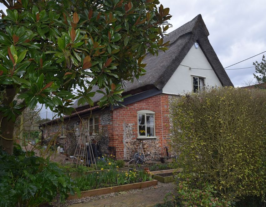
Contents

1.    Introduction ................................................................................................................ 3
2.    Statutory Designations ............................................................................................... 4
3.    Historical Setting. ..................................................................................................... 18
  3.1. Historical Maps ................................................................................................. 18
  3.2. Historical Setting. .............................................................................................. 23
4. Site Photographs ..................................................................................................... 26
5.    Statement of Significance ........................................................................................ 31
6.    Impact Statement ..................................................................................................... 35
7.    References............................................................................................................... 38

                   April 2021 | GBH | Nicolaas Joubert Historic Buildings Consultant.                                    1
Table of Figures
Figure 1: Extract from the 1838 Tithe Map of Great Bricett. ........................................... 18
Figure 2: Extract from the 1838 Tithe Map of Great Bricett. ........................................... 19
Figure 3: Extract from the First Edition OS Map of Great Bricett dated 1885. ................ 20
Figure 4: Enlarged extract from the First Edition OS Map of Great Bricett dated 1885. . 20
Figure 5: Extract from the Second Edition OS Map of Great Bricett dated 1904. ........... 21
Figure 6: Enlarged extract from the Second Edition OS Map of Great Bricett dated 1904.
 ........................................................................................................................................ 21
Figure 7: Sale Particulars Plan of Great Bricett Hall dated 1921. ................................... 22
Figure 8: Proposed development site to North of Pound Hill Cottage. ............................ 26
Figure 9: View to South from the edge (access track) of the proposed proposed
development site to North of Pound Hill Cottage. ........................................................... 27
Figure 10: View towards Bricett Hall Farm Buildings to the South West of the
development site. ............................................................................................................ 27
Figure 11: View towards Bricett Hall Farm Buildings to the South West of the
development site. ............................................................................................................ 28
Figure 12: View towards Great Bricett Hall and the Church of St Mary & St Lawrence to
the South West of the development site. ........................................................................ 28
Figure 13: View from the nearest edge of the development site to Great Bricett Hall and
the Church of St Mary & St Lawrence to the South West. .............................................. 29
Figure 14: South view towards The Street from Pound Hill and The Old Vicarage. ....... 29
Figure 15: North view along The Street, St Peter’s Court to left. .................................... 30
Figure 16: View from the East corner of the Church of St Mary & St Lawrence’s
churchyard towards the proposed development site. ...................................................... 30

                    April 2021 | GBH | Nicolaas Joubert Historic Buildings Consultant.                                         2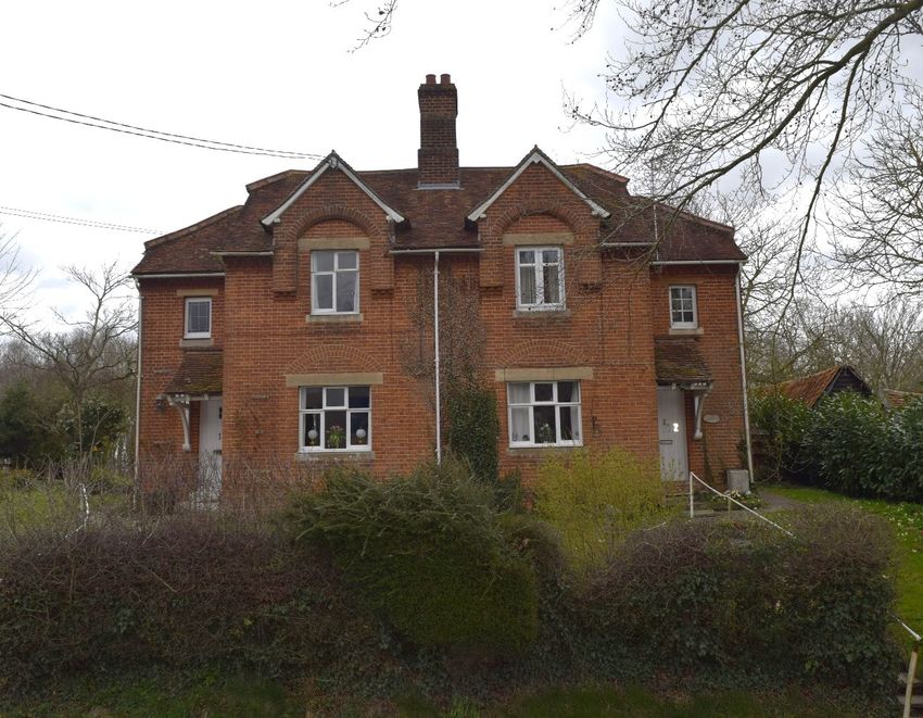
1. Introduction
1.1.      This document presents a Heritage and Impact Statement on Land
   north of Pound Hill Cottage, Pound Hill, Great Bricett, in Suffolk. IP7 7DN.

1.2.      Great Bricett, in the Hundred of Bosmere and Claydon, has a rich
   history dating back to the Roman period. The Manor of Great Bricett
   (dwelling or fold) was established by the Anglo-Saxons and was recorded
   in the Domesday Book (1086) with a population of just 28 souls. By 1444
   the Manor was vested to King’s College, Cambridge by Henry VI until 1996
   when it was purchased by Rupert Cooper. He acquired Great Bricett Hall
   Farm from the Provost and Fellows of King’s College in 1947. The farm
   remained in the family until 2018 when it was sold to Nick Thomson, the
   present owner of Hall Farm.
   Great Bricett in Suffolk is located about 4 miles to the South West of
   Needham Market with Bildeston as its postal town. The small village can
   best be described as having a ribbon development pattern that is somewhat
   dispersed.      The rural village developed very much in dependence of
   Manor/Hall Farm (Great Bricett Hall Farm) which over time employed most
   of the historic population of Great Bricett in the agricultural industry.
1.3.      The assessment was commissioned by Dean Jay Pearce
   Architectural Design and Planning Ltd in advance of a Planning and Listed
   Building Application for the erection of 4No. ‘Estate’ cottages (2No. semi-
   detached pairs) for long-term rental on land to the North of Pond Hill
   Cottage.
1.4.      The Heritage Assessment was carried out by Nicolaas Joubert
   Historic Buildings Consultant (MSc. Conservation).

        April 2021 | GBH | Nicolaas Joubert Historic Buildings Consultant.     3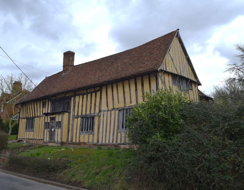
2. Statutory Designations

2.1.      The proposed development site is not within a Conservation Area,
    Special Landscape Area or BUAB.

2.2.      Below is a current Ordnance Survey Map of Great Bricett locating the
    designated and un-designated heritage assets within the setting of the
    proposed development site.

                                                    Red – Designated Hertiage Assets
                                                    Black – Non-Designated Hertiage Assets
                                        H           Relevant views

                        G

                                                                      E
                                                                             D
                                          A                           F
C                                                 B

2.3.      Description of identified Heritage Assets:

        April 2021 | GBH | Nicolaas Joubert Historic Buildings Consultant.        4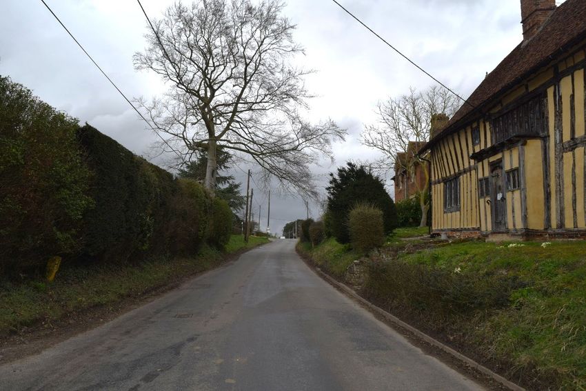
A - Great Bricett Hall

National Grid Reference: TM 03844 50681

Designation: Grade I Listed
List Entry Number: 1032976
Description:
Farmhouse; built as the hall of the Augustinian Priory of St. Leonard and attached
to the north side of the church (see above item). Mid C13 with alterations of early
C14, late C16, c.1770 and mid C19. Timber-framed and plastered. Hipped
plaintiled main roof with axial and end chimneys of C19 red brick. Main range of
3-cell cross-entry plan. 2 storeys. Mid C19 sashes and panelled entrance door
at cross entry, another doorway at rear of cross-entry is similar but with iron
trelliswork porch. A very rare example of a C13 timber-framed domestic
structure, with carpentry of the highest quality. A 2- bay open hall is at the centre,
with an integral storeyed bay at the south end. At the north end of the hall is a
cross-entry; the service cell was almost or entirely rebuilt c.1770. The hall had
(until C16) an aisle on the west side; the east side was not aisled, but had a
structure attached, either a porch or cloister. In the cross-entry is a composition
of 3 service doorways, and a 4th smaller but more richly carved. The doorways
have lap- jointed equilateral arches, and shafts with moulded capitals; the lower
doorway has in addition a band of dogtooth carving and mutilated foliate capitals.
The closed truss above has two pairs of passing braces one above the other,
and a pair of saltire braces at the centre, with studwork at 1.2m centres. The
open truss of the hall is depleted, but had straight tie-beam braces and massive
clasping passing-braces; the eastern post is unmoulded (being in an external

           April 2021 | GBH | Nicolaas Joubert Historic Buildings Consultant.   5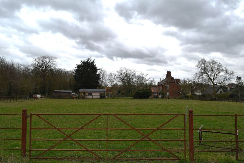
wall) and the arcade post to the west is missing. The closed truss at the upper
end of the hall is similar to the other but has divergent braces crossing the
passing-braces to form saltires. The truss was jettied into the hall over the dais
(until altered in perhaps C18), and there is evidence for a massive supporting
archbrace, perhaps one of a series. Splayed and tabled scarf joints with
undersquinted butts. The medieval roof was rebuilt c.1770, but many C13 and
C15 rafters are reused, the former having had notch-lap jointed collars but no
other bracing (apart from passing-braces at trusses). In early C14 a wing was
added to the south-west corner; it contained a solar of at least 3 bays, of which
2 remain. The main open truss has a cambered tiebeam with ovolo moulding
continuing along the thick archbraces and applied cornice. Two long slender
knee-braced octagonal crownposts with roll-moulded capitals. (compare Church
of St. Mary, Flowton, Item 6/110). The hall has a mid/late C16 inserted upper
floor with moulded joists. Circa 1600, the west wing was truncated and extended.

1921 Sale Particulars:
An attractive old house situate adjoining Great Bricett Church, timber framed,
stucco and tiled, contains the following accommodation:-
On the Ground Floor.-Entrance Porch, front Entrance Hall and Garden, Passage
and Entrance with front Staircase; Drawing Room with boarded floor, fireplace
and white marble chimney piece; Dining Room with boarded floor, fireplace and
grey marble chimney piece, opening into China Pantry with tiled floor and
shelving; Covered Way by the Garden Entrance leads to Office with tiled floor
and fireplace and Earth Closet; Morning Room in lean-to with bay window and
door, fireplace and recessed cupboards; Back Passage with back Garden door
and Back Staircase, leading to Larder and Pantry with paved floor; Kitchen with
paved floor; Back Kitchen with paved floor, open fireplace, baking oven, copper
and sink; Dairy with brick floor and shelving. A separate Staircase leads to two
Rooms over the Back Kitchen and Dairy.
On the First Floor.--Bedroom over Drawing Room fitted with fireplace and large
cupboard; Landing, Bath Room fitted with bath and waste. Bedroom over Dining
Room fitted with fireplace, Bedroom over Pantry, etc., Bedroom over Kitchen with
fireplace and large cupboard; 2 Maids' Bedrooms over the Kitchen and back
portion, and Back Staircase. On the Attic Floor, Lumber Rooms.
Significance: High
Grade I, Grade II* and Grade II Listed Buildings and built heritage of
exceptional quality.
Grade I, Grade II* and Grade II Registered Parks and Gardens and historic
landscapes and townscapes which are extremely well preserved with
exceptional coherence, integrity, time-depth, or other critical factor(s).

High Evidential, Aesthetic, Historic, and Communal Value.

Location: South West of Development Site (See Map above)

           April 2021 | GBH | Nicolaas Joubert Historic Buildings Consultant.   6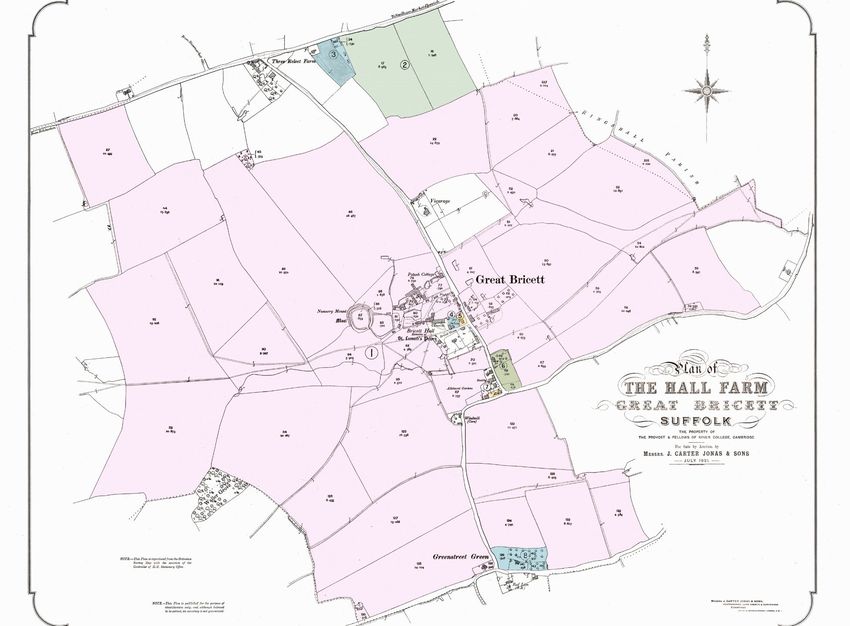
B - Church of St Mary & St Lawrence

National Grid Reference: TM 03865 50677

Designation: Grade I Listed
List Entry Number: 1352160
Description:
Parish church; originally the church of the priory of St. Leonard, founded 1114-
19 for Augustinian canons from St. Leonard de Noblat; the priory was dissolved
in 1444 and granted by Henry VI to his college in Cambridge. Nave, chancel,
south porch. Mainly of random flint rubble with freestone dressings; much
medieval remodelling with limestone and tile rubble, and later brick rubble. C19
brick at upper levels. Continuous plaintiled roof. The core of the early C12 church
remains, but was extended at both ends later in C12, and underwent repeated
alterations throughout the Middle Ages. Fine late C12 south doorway with rich
carving to jambs, shafts, imposts and arched head. In the jambs are 8 reused
stones with carved inscription, of which one word is LEONARDUS. These
probably come from the original early C12 doorway a little to the east, whose
former position is marked by a very early scratch dial. A number of C12 features
remain: blocked tall west doorway with window above, blocket lancets in north
and south walls. There were two C12 transepts in the chancel; these were
demolished and (on the south side) a window inserted in mid C13, with a good
hood-moulded doorway beside it. Blocked early C13 arches. on north and south
sides of chancel, which led to transeptal chapels at the extreme east end. These
in turn were demolished in C14, and the south arch has w:Lthin it a C14
crocketed and pinnacled piscina and a window. The north arch also has an

           April 2021 | GBH | Nicolaas Joubert Historic Buildings Consultant.   7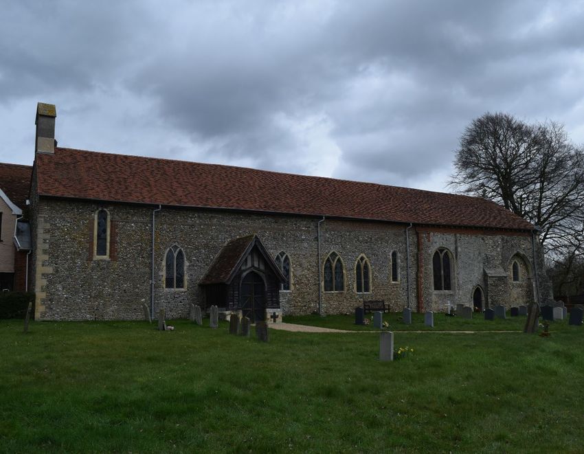
inserted window. In the south wall are several C13 and C14 Y- traceried windows
and a plain C14 piscina. The east wall was rebuilt in 1868; the east window is in
the mid C14 manner and is perhaps original and reconstructed; 4 panels of C14
glass in another window were formerly in the east window with much other glass.
Early C15 crownpost roof over the nave; the archbraced tiebeams are moulded
and the wallpieces have moulded pilasters. Similar chancel roof is later, perhaps
rebuilt with removal of chancel arch. A fine font of late C12: square limestone
bowl enriched with interlaced arcading and shafts with foliate capitals. Plain
square stem and base. Hexagonal oak pulpit with rows of carved sunk trefoils
and bands of quatrefoils above and below, and one side has good window
tracery; the pulpit is in the manner of C15 but possibly constructed (or
assembled) in C19. A wall monument of marble to John Bright of Tollemach Hall,
Little Bricett, d.1680. An archaeological plan of the church showing its complex
evolution is on the north wall.
Significance: High
Grade I, Grade II* and Grade II Listed Buildings and built heritage of exceptional
quality.
Grade I, Grade II* and Grade II Registered Parks and Gardens and historic
landscapes and townscapes which are extremely well preserved with
exceptional coherence, integrity, time-depth, or other critical factor(s).

High Evidential, Aesthetic, Historic, and Communal Value.

Location: South West of Development Site (See Map above)
Additional Information:
Ralph FitzBrian and Emma his wife, about the year 1110, founded a priory for
Austin canons at Bricett, which was dedicated to the honour of St. Leonard. The
foundation charter endowed the priory with the tithes of Bricett and of 'Losa' with
its chapel, a moiety of the church of 'Stepla,' and the church of Stangate, Essex,
in addition to various plots of land in the vicinity. The founder also gave to the
canons a large garden on the south of the monastery and a smaller one on the
east, and he ordained that whenever he was in Suffolk the canons were to act
as his chaplains and to receive a tithe of his bread and beer.
These gifts, with slight additions, were confirmed to the canons both by the son
and grandson of the founder and by Sir Almaric Peche, who married the great
granddaughter and heiress. In 1250, Walter bishop of Norwich, with the assent
of the prior and convent, licensed a chantry in the chapel of Sir Almaric and his
lady, within the court of their house, on condition that the chantry chaplain, at his
first coming, should swear, in the presence of the prior, to restore to the mother
church of Bricett every kind of offering made in the chapel, without any deduction,
on the day or the day after the offering was made; and also that no parishioner
should be admitted to the sacrament of penance or any other sacrament by the
chaplain, save in peril of death. It was also stipulated that Almaric and his wife
and household and their heirs should attend the mother church at Christmas,
Easter, Pentecost, the Assumption, and St. Leonard's Day, and make the
accustomed offerings at high mass.
Although the founder had enjoined that the canons of this house were to be under
the special protection of the Bishop of Norwich, and that the prior was to have
           April 2021 | GBH | Nicolaas Joubert Historic Buildings Consultant.   8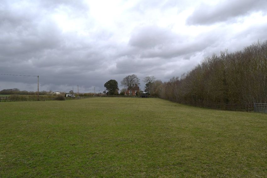
the power of appointing and removing canons, the priory of Bricett was claimed,
early in the thirteenth century, as pertaining to the monastery of Nobiliac, in the
diocese of Limoges and the duchy of Berry. This claim was resisted, but in 1295
an agreement was arrived at favourable to the foreign house, whereby Bricett
became an alien priory; this composition was renewed and confirmed by the
Bishop of Norwich in the chapter-house of Bricett, on 16 July, 1310.
The taxation roll of 1291 gives the annual value of the temporalities of Bricett
priory in various Suffolk parishes and in Pentlow, Essex, as £13 18s. 0½d. Under
spiritualities there was the church of Wattisham with an income of £5 6s. 8d. and
portions from Castle Acre of £1 13s. 4d., and from Wenham of 6s.
In a long list of royal protections to religious houses in 1295, in return for
bestowing on the king a tithe of their income, the priory of Bricett is described as
a cell to the priory of 'Noblac in Lymoches.'
In 1325 Thomas Durant and Margaret his wife obtained licence to enfeoff John
de Bohun of a fourth part of the manor of Great Bricett, together with the
advowson of the priory of St. Leonard of the same town.
Licence was granted in 1331 for the alienation by Thomas le Archer, rector of
Elmsett, and Richard his brother, to the prior and canons of Bricett of three parts
of the manor of Great Bricett, of the yearly value of £7. The fourth part of the
manor of Great Bricett of the annual value of 36s. 8d. was assigned to the priory
in 1346 by Richard Hacoun and Anne his wife. In the same year John Bardoun
and Isabel his wife released to the prior and canons of St. Leonard's all their right
and claim in the manor of Great Bricett.
The prior, with a great number of other priors of alien houses and cells, was
summoned to appear before the council at Westminster, on the morrow of
Midsummer, 1346, 'to speak with them on things that shall be set forth to them,'
upon pain of forfeiture and the loss of the priory, lands, and goods.
¶On the general suppression of the alien priories, Bricett came into the hands of
the crown. In 1444 Henry VI granted the whole of the possessions to the college
of SS. Mary and Nicholas (afterwards King's), Cambridge. This grant was
confirmed by the same king in 1452, and it was again renewed by Edward IV in
the first year of his reign, namely on 24 February, 1462.

           April 2021 | GBH | Nicolaas Joubert Historic Buildings Consultant.   9
C - Great Bricett Moated Site
National Grid Reference: TM 03683 50678
Designation: Scheduled Monument - Monument record BCG 026 - Medieval
Moat and Priory: Nunnery Mount and land adjoining Great Bricett Church, Great
Bricett (BCG 026)
List Entry Number: 1006048
Description:
June-December 2016: Magnometer survey in Nunnery mount and land
adjancent to great Bricett Church.
Garden North of Church: A strong linear feature crossed the site which appears
on the 1883 OS map as a dashed line indicating either a path or a boundary. In
the western third of the plot, it is evident that noise levels are generally high.
Excavations in the 20th century revealed foundations of chapels extending into
this area (plan by PGM Dickinson 1957 in the church) and these could be partly
responsible for this ‘noise’, but there is not enough detail for this to be
diagnostic of any particular building or structure. No evidence was, however,
found of the cloister and its associated structures as hypothesised by
Dickinson.
Churchyard: The intention of the churchyard survey was to establish whether
the Dickinson plan of the church, showing chapels extending to the south of the
April 2021 | GBH | Nicolaas Joubert Historic Buildings Consultant. 10chancel, could be validated. However, as anticipated, ferrous material in the
churchyard obscured any subtle detail. The strong striping and polar response
strip to the north of the churchyard was caused by the church roof's iron
guttering. Gravestones, manhole covers and services accounted for the other
ferrous responses. The cluster of iron responses in the eastern half of the
output was from modern gravestones where metal dowelling is used to lock
headstones to their bases.
Nunnery Mount: Outside the Mount, the pentagonal enclosure is clear,
although the line of the north eastern side is obscured by responses from
fencing and buildings. Up to recent times the enclosure was open ditches and it
is apparent that much ferrous debris is in their fill, particularly the southern arm,
probably from scrap farm machinery and the like. To the north, two linears
running NW and NE are the lines of former field boundaries. In the southwest
quadrant, a former field boundary runs southwest to northeast. Crossing the
southwest quadrant field boundary linear is one well-defined right-angled
response line, which is probably a ditch. Alongside it is an irregular, broader
and less well defined linear, whose line is part-filled in by a ferrous response.
Rather than a single feature, it could be a small number of separate response
areas. The ditch line is unusual and suggests that it is going round one side of
a feature, which may be part obscured by the assumed later field boundary.
Confidence in this interpretation is not high, though. (S1)
Significance: Good
Scheduled Monuments, or assets of national quality and importance, or that
can contribute to national research objectives.
Grade II* and Grade II Listed Buildings, Conservation Areas with very strong
character and integrity, other built heritage that can be shown to have
exceptional qualities in their fabric or historical association.
Grade II* and II Registered Parks and Gardens, Registered Battlefields and
historic landscapes and townscapes of outstanding interest, quality and
importance, or well preserved and exhibiting considerable coherence, integrity
time-depth or other critical factor(s).
Location: West of Development Site
April 2021 | GBH | Nicolaas Joubert Historic Buildings Consultant. 11D - St Peter’s Court
National Grid Reference: TM0395650692
Designation: Grade II Listed
List Entry Number: 1032975
Description:
House; c.1500, with early and late C16 alterations. A 3-cell house, the nucleus
consisting of an open hall of Wealden type. 2 storeys. Timber-framed and
plastered; the close-studding of all 3 phases fully exposed with plaster infill
panels. Plaintiled roof with axial C17 chimney of red brick. Mainly late C20 oak
cavetto-mullioned windows, many in original openings. C20 oak-framed
entrance porch with plank door; reused C17 ovolo-mullioned windows in the
porch with leaded glazing. The 2-bay open hall is all that survives of the original
house, formerly having a cross-entry to right. The open truss has a cambered
tie-beam with cranked arch braces and shafts beneath (one damaged). Evidence
for a crownpost (roof renewed C20). Good tension-braced close studding. The
upper wall framing, although damaged, gives clear evidence for Wealden-type
construction, although with unusual details: the flying wall-plate at the
overhanging eaves has been removed, but mortices for its supporting braces
remain. The rear wall has had reversed assembly at the open truss, and the
crownpost was not central upon its tie-beam. These features are all associated
with the asymmetrical roof over a Wealden house. What is not normal is evidence
for an unjettied service cell to right of the hall, implying that the flying wallplate
continued to the end of the building. Circa 1530, an upper floor was inserted over
the lower bay of the hall; a fine moulded and brattished beam supporting the roll-
April 2021 | GBH | Nicolaas Joubert Historic Buildings Consultant. 12and-cavetto moulded joists; a similarly moulded dais beam was attached to the
upper end of the hall. Also c.1530 the service cell was demolished and a parlour
block built; it has a massive moulded bridging beam and unchamfered joists. An
external doorway at this end has an arched head with sunk spandrels. In late
C16, the original parlour cell to left was rebuilt, with good close-studding, 2-tier
butt-purlin roof, and arched parlour fireplace.
Significance: Medium/Moderate
Grade II Listed Buildings, Conservation Areas, locally listed buildings and
undesignated assets that can be shown to have good qualities in their fabric or
historical association.
Grade II Registered Parks and Gardens, Registered Battlefields, undesignated
special historic landscapes and townscapes with reasonable coherence,
integrity, time-depth or other critical factor(s).
Medium/Moderate Evidential, Aesthetic and Historic Value.
Location: South East of Development Site (See Map above)
April 2021 | GBH | Nicolaas Joubert Historic Buildings Consultant. 13E - Pound Hill Cottage & Hill Cottage
National Grid Reference: TM 03949 50719
Designation: Non-Designated Heritage Asset
Description: (External Only)
Two semi-detached cottages (Originally estate cottages associated with Bricett
Hall Farm); c.1870s; 2 storeys; Red brick (Flemish bond) and plain tiled; Half-
hipped roofs; Each cottage having a 2-storey side wing with entrance lobby and
staircase; Central stack serving both cottages, shouldered and have projecting
brickwork; Modern casement windows, with flat ‘stone’ arches; Decorative
gabled dormers to front roof slope having decorative projecting segmental
arches over, decorative flush segmental arches to ground floor windows in the
same elevation; Single-storey pantiled extensions to rear.
Hall Cottage served as a post office between 1978 and 1991.
1921 Sale Particulars of the cottages: A pair of modern cottages, red brick and
tiled, each containing front porch, entrance lobby and staircase, living room front
with stove, kitchen back with stove, copper and sink, large Pantry with brick floor
and shelving, and 3 bedrooms. Good gardens with outbuildings at the back
comprising of a bakehouse with baking oven and Closets.
Significance: Low to medium with good evidential, aesthetic and historic
value.
Location: South East of Development Site (See Map above)
April 2021 | GBH | Nicolaas Joubert Historic Buildings Consultant. 14F - Pound Cottage
National Grid Reference: TM 03934 50686
Designation: Non-Designated Heritage Asset
Description: (External Only)
Single cottage; Late C18 or Early C19 (interior not inspected); 1 ½ storeys; Flint
& Brick, the upper section of gable ends rendered; Thatched; Casement
windows; Single-storey pantiled lean-to extensions to rear.
1921 Sale Particulars of the cottages: Brick, flint, and thatch with a pantiled lean-
to at back. Contains 2 living rooms, 2 pantries, and 2 bedrooms. Outbuildings:
brick and tile, comprise of piggeries, shed, and closet.
Significance: Low to medium with good evidential, aesthetic, and historic
value.
Location: South West of Development Site (See Map above)
April 2021 | GBH | Nicolaas Joubert Historic Buildings Consultant. 15G – Great Bricett Hall Barn
National Grid Reference: TM 03789 50749
Designation: Non-Designated Heritage Asset
Description:
Threshing barn with 2No. threshing floors; Part c.1600 or earlier. 8-BayTimber
framed construction and seated on red brick plinth walls; Reused timbers
evident; Clasped side-purlin roof structure covered with corrugated metal roof
sheeting; End gable walls removed.
1921 Sale Particulars of the barn: Corn Barn with Porch, timber and thatched,
with lean-to Implement Shed at end.
Significance: Medium with good evidential, aesthetic and historic value.
Location: South West of Development Site (See Map above)
April 2021 | GBH | Nicolaas Joubert Historic Buildings Consultant. 16H – The Old Vicarage
National Grid Reference: TM 03830 50970
Designation: Non-Designated Heritage Asset
Description:
Vicarage House; built 1875 as a gift of King’s College, Cambridge; 2 storeys,
double-pile arrangement with slate tile roofs (single slope on South elevation);
Redbrick (Flemish bond) construction; Internal gable end stack to each pile at
North end (both shouldered and have projecting brickwork); near central internal
stack to the South end of the house; casement windows with segmental arches,
cross-casements to ground floor; bay window to the ground floor of the South
elevation; gabled, slate tiled, timber, glazed and red brick entry porch on West
elevation, single storey, hipped and slate tiled extension to North elevation.
Significance: Low to medium with good evidential, aesthetic, historic, and
communal value.
Location: South West of Development Site (See Map above)
April 2021 | GBH | Nicolaas Joubert Historic Buildings Consultant. 173. Historical Setting.
3.1. Historical Maps
Extract from the Tithe Map of the Parish of Great Bricett in the County of
Suffolk, 1838 (IR 30/33/70).
Proposed Development
Site.
Bricett Hall & Church of
St. Mary and St.
Lawrence.
Figure 1: Extract from the 1838 Tithe Map of Great Bricett.
April 2021 | GBH | Nicolaas Joubert Historic Buildings Consultant. 18Proposed Development
Site.
Figure 2: Extract from the 1838 Tithe Map of Great Bricett.
April 2021 | GBH | Nicolaas Joubert Historic Buildings Consultant. 19OS County Series: Suffolk 1:2500 1885
Figure 3: Extract from the First Edition OS Map of Great Bricett dated 1885.
Proposed Development
Site.
Bricett Hall & Church of
St. Mary and St.
Lawrence.
Figure 4: Enlarged extract from the First Edition OS Map of Great Bricett dated 1885.
April 2021 | GBH | Nicolaas Joubert Historic Buildings Consultant. 20OS County Series: Suffolk 1:2500 1904
Malting Farm.
Figure 5: Extract from the Second Edition OS Map of Great Bricett dated 1904.
Proposed Development
Site.
Bricett Hall & Church of
St. Mary and St.
Lawrence.
Figure 6: Enlarged extract from the Second Edition OS Map of Great Bricett dated 1904.
April 2021 | GBH | Nicolaas Joubert Historic Buildings Consultant. 211921 Sale Particulars Plan of Great Bricett Hall.
Figure 7: Sale Particulars Plan of Great Bricett Hall dated 1921.
April 2021 | GBH | Nicolaas Joubert Historic Buildings Consultant. 223.2. Historical Setting.
3.2.1 The earliest map illustrated within this study is the 1838 Tithe Map of
Great Bricett supported by the 1841 Tithe Apportionments. In 1838 the site
of the proposed development formed part of a larger pastoral field that was
known as Dove House Pasture (No. 88 on the 1838 Map). According to the
1838 Tithe Map, this field formed part of Lilly’s Farm and was comprised of
just over 83 acres, and was in the ownership of Mrs. Jamima Newen. The
farmland was farmed by a tenant farmer know as George Mumford. St.
Peter’s Court and its farm buildings (Nos. 93 & 89 on the 1838 Map), shown
to the East, appears to have served as the homestead for Lilly’s Farm. At
this date, the farmhouse was occupied by James Bloomfield and his wife
Mary. He was an agricultural labourer. They were still residents at St. Peter’s
Court in 1851 when part of the farmhouse was in use as a day school. There
doesn’t appear to be any other records for Jamima Newen related to Great
Bricett other than landholdings suggesting that she was not a resident there.
The 1838 Map shown two cottages (Nos. 91 & 92) to the North of St. Peter’s
Court. The cottage adjacent to St. Peter’s Court is shown in the same
location as Pound Hill and Hall Cottage but does not resemble the footprint
of the existing semi-detached dwellings. Both cottages to the North of St.
Peter’s Court were in the ownership of Thomas Tampen and occupied by
the Grimwood family and other agricultural labourers. As a point of interest,
the Grimwood family also had a tenancy on a cottage further North
belonging to Kings College Cambridge. The family served as agricultural
labourers in Great Bricett throughout the C19 and also during the C20.
3.2.2 In 1444 Henry VI granted the whole of the possessions (Manor of
Bricett) to the college of SS. Mary and Nicholas (afterward King's),
Cambridge. In 1838 George Mumford was resident at Hall Farmhouse
(Great Bricett Hall) as the tenant farmer to King’s College Cambridge
Provost Scholars and Fellows. He was a landholder in Great Bricett before
this date as suggested by the 1832 Poll Rolls for Great Bricett. At the time
of the 1841 Tithe Apportionments, Mumford's tenancy from King’s College
Cambridge included three farms and other fields; Hall Farm - just over 296
April 2021 | GBH | Nicolaas Joubert Historic Buildings Consultant. 23acres, Adam’s Farm to the East of Hall Farm – just over 21 acres, Gatling
Farm to the South of Hall Farm – just over 52 acres. Including his own
landholdings and tenancy lands, George Mumford was farming over 483
acres of land by 1851. Pond Cottage to the West of St. Peter’s Court was
also in the ownership of Mumford and occupied by two agricultural
labourers. Field No. 67 on the Tithe Map, on which The Old Vicarage was
later built, was also in the ownership of George Mumford.
3.2.3 From the 1870s to c.1917 Hall Farm was occupied by the Gowing
family (Ephriam Edward Gowing then his son Arthur Edward Gowing). By
1871 Hall Farm was the largest farm within the area and extended to 438
acres. The School House West of Pond Cottage was built in 1870 and
enlarged in 1880 and 1893. A comparison between the 1838 Tithe Map and
the 1885 First Edition Ordnance Survey map illustrates a change in the form
of the footprint to the first cottage shown North of St Peter’s Court. It appears
that the earlier cottage was demolished and replaced with the semi-
detached dwellings known as Pond Hill Cottage and Hall Cottage. The
replacement estate cottages appear to date to the 1870s (possibly late
1860s). The Old Vicarage was built in 1875 as a gift of King’s College
Cambridge and closed in 1956.
3.2.4 Only minor changes to the surrounding setting of the development site
were carried out between 1885 and 1904 as shown in Figs. 3 and 5.
3.2.5 Figure 7 illustrates the 1921 Sale Particulars Map of Hall Farm which
was to be sold as a freehold property. The farm was let to Mr. H.S Bryant
who agreed to terminate his tenancy later the same year. In 1921 Hall Farm
comprised 385 acres of arable and pasture land. The sale included Great
Bricett Hall and farm, a shop, and 13 cottages to be sold in Lots. As
illustrated on the 1921 Map the proposed development site, St Peter’s
Court, Pond Cottage, The School House, Pound Hill Cottage, Hall Cottage,
and a cottage to the North of the latter two, which was demolished between
1952 and 1972, all formed part of the Great Bricett Hall Estate. These
properties appeared to have been acquired by the Provost and Fellows of
King’s College Cambridge between c.1844 and the 1860s.
3.2.6 During the Second World War, the farmhouse was used to house Italian
April 2021 | GBH | Nicolaas Joubert Historic Buildings Consultant. 24prisoners of war. In 1947 Hall Farm was acquired by Rupert Cooper (and
his father Percy) and the land holdings extended to around 1250 acres.
Rupert Cooper bought the lordship of the Manor of Great Bricett in 1996
from King’s College Cambridge and passed it to his son Oliver Cooper. Hall
farm was put up for sale in June 2018 and purchased by Nick Thomson in
August of the same year.
April 2021 | GBH | Nicolaas Joubert Historic Buildings Consultant. 254. Site Photographs
Pound Hill Cottage
Pound Cottage
PROPOSED DEVELOPMENT SITE
Figure 8: Proposed development site to North of Pound Hill Cottage.
April 2021 | GBH | Nicolaas Joubert Historic Buildings Consultant. 26Figure 9: View to South from the edge (access track) of the proposed development site to
North of Pound Hill Cottage.
Figure 10: View towards Bricett Hall Farm Buildings to the South West of the development
site.
April 2021 | GBH | Nicolaas Joubert Historic Buildings Consultant. 27The Old Vicarage
PROPOSED DEVELOPMENT SITE
Figure 11: View towards Bricett Hall Farm Buildings to the South West of the development
site.
Church of St Mary &
St Lawrence
Great Bricett Hall
PROPOSED DEVELOPMENT SITE
Figure 12: View towards Great Bricett Hall and the Church of St Mary & St Lawrence to the
South West of the development site.
April 2021 | GBH | Nicolaas Joubert Historic Buildings Consultant. 28Figure 13: View from the nearest edge of the development site to Great Bricett Hall and the
Church of St Mary & St Lawrence to the South West.
Development Site
Figure 14: South view towards The Street from Pound Hill and The Old Vicarage.
April 2021 | GBH | Nicolaas Joubert Historic Buildings Consultant. 29Figure 15: North view along The Street, St Peter’s Court to left.
Figure 16: View from the East corner of the Church of St Mary & St Lawrence’s churchyard
towards the proposed development site.
April 2021 | GBH | Nicolaas Joubert Historic Buildings Consultant. 305. Statement of Significance
5.1. A heritage asset is defined within the NPPF as “a building,
monument, site, place, area or landscape identified as having a degree of
significance meriting consideration in planning decisions, because of its
heritage interest. Heritage asset includes designated heritage assets and
assets identified by the local planning authority (including local listing).”
(NPPF Annex 2: Glossary)
5.2. The significance of the heritage assets within the proposed site
require assessment in order to provide a context for, and to determine the
impact of, the current development proposals. Significance is defined as
"the value of a heritage asset to this and future generations because of its
heritage interest. That interest may be archaeological, architectural, artistic
or historic. Significance derives not only from a heritage asset’s physical
presence, but also from its setting." (NPPF Annex 2: Glossary). The aim of
this Heritage Statement is to identify and assess any impacts that the
proposed development may cause to the value or significance of the
identified heritage assets and/or their settings. Impact on that value or
significance is determined by considering the sensitivity of the receptors
identified and the magnitude of change.
5.3. Beyond the criteria applied for national designation, the concept of
value can extend more broadly to include an understanding of the heritage
values a building or place may hold for its owners, the local community or
other interest groups. These aspects of value do not readily fall into the
criteria typically applied for designation and require a broader assessment
of how a place may hold significance. In seeking to prompt broader
assessments of value, Historic England’s Conservation Principles
categorises the potential areas of significance (including and beyond
designated assets) under the following headings:
• Evidential value – ”derives from the potential of a place to yield evidence
about past human activity…Physical remains of past human activity are the
primary source of evidence about the substance and evolution of places,
and of the people and cultures that made them…The ability to understand
April 2021 | GBH | Nicolaas Joubert Historic Buildings Consultant. 31and interpret the evidence tends to be diminished in proportion to the extent
of its removal or replacement.” (Page 28)
Evidential value therefore relates to the physical remains of a
building/structure and its setting, including the potential for below ground
remains, and what this primary source of evidence can tell us about the past.
• Aesthetic Value – ”Aesthetic values can be the result of the conscious
design of a place, including artistic endeavour. Equally, they can be the
seemingly fortuitous outcome of the way in which a place has evolved and
been used over time. Many places combine these two aspects… Aesthetic
values tend to be specific to a time cultural context and appreciation of them
is not culturally exclusive.” (Pages 30-31)
Aesthetic value therefore relates to the visual qualities and characteristics
of an asset (settlement site or building), long views, legibility of building form,
character of elevations, roofscape, materials and fabric, and setting
(including public and private views).
Historic Value – ”derives from the ways in which past people, events and
aspects of life can be connected through a place to the present. It tends to
be illustrative or associative… Association with a notable family, person,
event, or movement gives historical value a particular resonance...The
historical value of places depends upon both sound identification and direct
experience of fabric or landscape that has survived from the past, but is not
as easily diminished by change or partial replacement as evidential value.
The authenticity of a place indeed often lies in visible evidence of change
as a result of people responding to changing circumstances. Historical
values are harmed only to the extent that adaptation has obliterated or
concealed them, although completeness does tend to strengthen illustrative
value.” (Pages 28-30)
Historic value therefore relates to the age and history of the asset, its
development over time and the strength of its tie to a particular architectural
April 2021 | GBH | Nicolaas Joubert Historic Buildings Consultant. 32period, person, place or event. It can also include the layout of a site, the
plan form of a building and any features of special interest.
• Communal Value – “Commemorative and symbolic values reflect the
meanings of a place for those who draw part of their identity from it, or have
emotional links to it… Social value is associated with places that people
perceive as a source of identity, distinctiveness, social interaction and
coherence. Some may be comparatively modest, acquiring communal
significance through the passage of time as a result of a collective memory
of stories linked to them…They may relate to an activity that is associated
with the place, rather than with its physical fabric…Spiritual value is often
associated with places sanctified by longstanding veneration or worship, or
wild places with few obvious signs of modern life. Their value is generally
dependent on the perceived survival of the historic fabric or character of the
place, and can be extremely sensitive to modest changes to that character,
particularly to the activities that happen there.” (Pages 31-32)
Communal value therefore relates to the role an asset plays in a historic
setting, village, town or landscape context, and what it means to that place
or that community. It is also linked to the use of a building, which is perhaps
tied to a local industry or its social and/or spiritual connections.
5.4. Historic England’s Conservation Principles also considers the
contribution made by setting and context to the significance of a heritage
asset.
• “‘Setting’ is an established concept that relates to the surroundings in
which a place is experienced, its local context, embracing present and past
relationships to the adjacent landscape.”
• “‘Context’ embraces any relationship between a place and other places. It
can be, for example, cultural, intellectual, spatial or functional, so any one
place can have a multi-layered context. The range of contextual
relationships of a place will normally emerge from an understanding of its
origins and evolution. Understanding context is particularly relevant to
April 2021 | GBH | Nicolaas Joubert Historic Buildings Consultant. 33assessing whether a place has greater value for being part of a larger entity,
or sharing characteristics with other places.” (Page 39)
5.5. In order to understand the role of setting and context to decision-
making, it is important to have an understanding of the origins and evolution
of an asset, to the extent that this understanding gives rise to significance
in the present. Assessment of these values is not based solely on visual
considerations, but may lie in a deeper understanding of historic use,
ownership, change, or other cultural influence – all or any of which may have
given rise to current circumstances and may hold a greater or lesser extent
of significance.
5.6. Refer to Section 2 para. 2.3.
April 2021 | GBH | Nicolaas Joubert Historic Buildings Consultant. 346. Impact Statement
Refer to drawings;
• 21/011/01 Site Plan
• 21/33/02 Proposed Site Plan
• 21/011/03 Proposed Plans and Elevations
6.1. The statutory duty of section 66(1) of the Planning (Listed Buildings
and Conservation Areas) Act 1990 informs to have special regard to the
desirability of preserving listed buildings or their setting or any features of
special architectural or historical interest which they possess.
6.2. The National Planning Policy Framework (NPPF) states that the
purpose of the planning system is to achieve sustainable development and
that protection and enhancement of the historic environment is an
overarching objective in this (paragraphs 7 & 8). The significance of listed
buildings can be harmed or lost by developing in their setting. The NPPF
states that clear and convincing justification should be made for any such
harm and that ‘great weight’ should be given to the conservation of listed
buildings irrespective of the level of harm caused (paragraphs193 and 194).
This weight and the justification for harm should be especially convincing
where harm to buildings of a high grade of listing is concerned. Paragraph
200 also states that the council should favour those proposals for
development that preserve those elements of the setting that make a
positive contribution to the heritage asset or better reveal its significance.
This justification should be especially convincing where harm to buildings of
a high grade of listing is concerned.
6.3. Paragraph 196 of the National Planning Policy Framework states:
‘Where a development proposal will lead to less than substantial harm to
the significance of a designated heritage asset, this harm should be weighed
against the public benefits of the proposal including, where appropriate,
securing its optimum viable use.’
April 2021 | GBH | Nicolaas Joubert Historic Buildings Consultant. 356.4. Paragraph 197 of the National Planning Policy Framework states:
‘The effect of an application on the significance of a non-designated heritage
asset should be taken into account in determining the application. In
weighing applications that directly or indirectly affect non-designated
heritage assets, a balanced judgment will be required having regard to the
scale of any harm or loss and the significance of the heritage asset.
6.5. It is proposed to erect 4No. ‘Estate’ cottages (2No. semi-detached
pairs) for long-term rental on land to the North of Pond Hill Cottage.
6.6. Within the context of the statutory duty of section 66(1) of the
Planning (Listed Buildings and Conservation Areas) Act 1990, the NPPF,
and Historic England’s Conservation Principles I consider that the scale of
harm posed by the proposed development scheme on the setting and
therefore the significance of the Grade I designated Church of St Mary and
St Lawrence and Great Bricett Hall is within the scale of very low less than
substantial harm. This level of harm is due to the change of use of a pastoral
field that was historically and functionally associated with the designated
heritage assets and which makes a positive contribution to their setting. The
impact is also related to views from the Grade I designated heritage assets
to the countryside beyond the undeveloped paddock. The proposal has
responded well to this potential impact by retaining gaps between the
existing and proposed dwellings which retains the open and partly dispersed
character of the immediate setting of the undeveloped paddock. The
proposal will therefore create a sense of openness and retain a visual
connection between the Grade I listed heritage assets and the open
countryside beyond the proposed development.
The proposed development does not pose any harm to the immediate
setting and therefore the significance of the Grade II listed St Peter’s Court.
There are three non-designated heritage assets to the North (The Old
Vicarage, Pound Hill Cottage, Hall Cottage) and one to the West (Pound
Cottage) of St Peter’s Court as shown in Section 2, para 2.2. These can be
considered to be potentially impacted by the proposed development. The
potential harm is similar to that of the Grade I designated heritage assets
April 2021 | GBH | Nicolaas Joubert Historic Buildings Consultant. 36and is related to views and change within the setting of the non-designated
heritage assets which may detract from the significance and character of
place and of the heritage assets. In terms of scale, character, materials, and
appearance the design and character of the proposed semi-detached
dwellings were informed by the Victorian architectural character of The Old
Vicarage to the North and Pound Hill Cottage and Hall Cottage to the South
which harmonizes well within the setting of the named non-designated
heritage assets. The placement of the development will reflect and sustain
the hierarchy of the historic buildings and the development character at the
North end of the settlement. The proposed gabs between the heritage
assets and the development site will not only retain the openness of the
setting but the green buffers will mitigate any sense of encroachment on the
non-designated.
As shown in the Proposed Street Scene (Drawing 21/33/02), the spacing
between the two pairs of semi-detached ‘estate cottages’, the use of post
and rail boundary fencing around the development, and concealed parking
will retain a sense of openness to the setting.
Bricett Hall Barn, a non-designated heritage asset, will not be affected by
the proposed development.
Overall I find that the proposal for the erection 2No. pairs of semi-detached
dwellings will have a very low impact on the setting and therefore the
significance of the designated and non-designated heritage assets within
view of the proposed development. The proposal will make a positive
contribution to the architectural interest and general setting of Pond Hill.
April 2021 | GBH | Nicolaas Joubert Historic Buildings Consultant. 377. References
• Monument Record, Suffolk Heritage Explorer [database online]
www.heritage.suffolk.gov.uk
• The National Heritage List for England. [database online]
www.historicengland.org.uk
• "Houses of Austin canons: Priory of Bricett." A History of the County of
Suffolk: Volume 2. Ed. William Page. London: Victoria County History,
1975. 94-95. British History Online. Web. 7 April 2021. http://www.british-
history.ac.uk/vch/suff/vol2/pp94-95.
• Tithe Map of the Parish of Great Bricett in the County of Suffolk, 1838 (IR
30/33/70) [database online]. TheGenealogist.co.uk
• Tithe Apportionments of the Parish of Great Bricett in the County of
Suffolk, 1841 (IR 29/33/70) [database online]. TheGenealogist.co.uk
• Census Transcript Search, 1841-1911 [database online].
TheGenealogist.co.uk 2020
• Poll Books [database online]. TheGenealogist.co.uk 2021
• Trade & Post Office Directories for Suffolk [database online].
TheGenealogist.co.uk 2021
• 1921 Sale Particulars and Map of Hall Farm, Great Bricett. [database
online]. www.greatbricett.suffolk.cloud
• O.S County Series Map: Suffolk 1:2,500 1885 [database online]. www.old-
maps.co.uk
• O.S County Series Map: Suffolk 1:2,500 1904 [database online]. www.old-
maps.co.uk
• National Planning Policy Framework
• Historic England; Conservation Principles, Policies, and Guidance
April 2021 | GBH | Nicolaas Joubert Historic Buildings Consultant. 38You can also read