Marine Conservation Zones - Consultation on sites proposed for designation in the third tranche of Marine Conservation Zones June 2018 - Citizen Space
←
→
Page content transcription
If your browser does not render page correctly, please read the page content below
Marine Conservation Zones
Consultation on sites proposed for
designation in the third tranche of
Marine Conservation Zones
June 2018
© Crown copyright 2018

You may re-use this information (excluding logos) free of charge in any format or medium,
under the terms of the Open Government Licence v.3. To view this licence visit
www.nationalarchives.gov.uk/doc/open-government-licence/version/3/ or email
PSI@nationalarchives.gsi.gov.uk

This publication is available at www.gov.uk/government/publications

Any enquiries regarding this publication should be sent to us at mcz@defra.gsi.gov.uk
MCZ Team
Defra
Seacole Building, 1st floor
2 Marsham Street
London
SW1P 4DF

www.gov.uk/defra
Contents
Foreword from the Secretary of State .................................................................................. 1

Executive summary ............................................................................................................. 3

Part A - Purpose and progress ............................................................................................ 6

   1.       Purpose of consultation .......................................................................................... 6

   2.       Consultation process .............................................................................................. 6

   3.       Confidentiality ......................................................................................................... 7

   4.       Evidence standards ................................................................................................ 7

Part B - Why we need MPAs including MCZs ...................................................................... 9

   6.       Ecologically coherent network .............................................................................. 10

Part C - Progress in establishing the MPA network ........................................................... 12

   8. Special Areas of Conservation and Special Protection Areas .................................... 12

   9. Sites of Special Scientific Interest (SSSIs) ................................................................. 12

   10. MCZs progress to date ............................................................................................. 13

   11. Management of MPAs .............................................................................................. 14

   12. Highly Protected Marine Areas ................................................................................. 15

   13. UK-wide picture ........................................................................................................ 15

   14. Scotland ................................................................................................................... 16

   15. Wales ....................................................................................................................... 16

   16. Northern Ireland ....................................................................................................... 17

Part D - MCZ third tranche: identifying sites for designation .............................................. 18

   18. Highly mobile species............................................................................................... 19

Part E - MCZ third tranche proposals ................................................................................ 20

   20. Residual ecological gaps.......................................................................................... 21

   21. Overview of new sites proposed for designation ...................................................... 22

Part F - Additional features in existing MCZs ..................................................................... 24
Part G - Management implications..................................................................................... 25

Part H - Impact assessment............................................................................................... 26

Part I - Next steps .............................................................................................................. 28

Part J - Consultation questions .......................................................................................... 29

   Questions applicable to all proposed new third tranche sites ......................................... 29

   Questions applicable to all additional features proposed for existing Marine
   Conservation Zones ....................................................................................................... 29

   General comments ......................................................................................................... 30

   Question on developing the MPA network after this third tranche .................................. 30
Foreword from the Secretary of State
The UK is surrounded by some of the richest and most diverse sea life in the world, from
the bright pink sea-fan coral colonies off the south-west coast, to the great chalk reef
stretches in the east. With almost 18,000 km of mainland coastline, we are the custodians
of the widest range of marine habitats in Europe.

Our seas and oceans, however, are also an integral part of our history, economy and way
of life. We all rely on a healthy marine environment, protected from persistent pollutants,
heavy metals and over-fishing.

Today, on World Oceans Day, I am delighted to launch this consultation to complete our
very successful Blue Belt programme in UK waters. This document proposes the creation
of 41 new Marine Conservation Zones (MCZs), alongside adding new features to 12
existing sites, making it the most significant expansion so far.

Our underwater habitats are a treasure trove of biodiversity and species richness; home to
dramatic clay cliffs, limestone, peat and sponge. We are often drawn to exotic creatures
like the short-snouted seahorse – also known as the Hippocampus hippocampus – but we
must also protect their habitats and the underwater geology that is, quite literally, our
bedrock.

Many of these species and habitats are under pressure from human activity, with our sea
life now less abundant than it could be.

We are taking action elsewhere by banning plastic microbeads in rinse-off cosmetics and
personal care products, taking nine billion single use plastic bags out of circulation through
our 5p carrier bag charge, and setting out our plans for a ban on plastic straws, stirrers
and cotton buds and the introduction of a deposit return scheme for plastic bottles.

It is only by granting special protection, however, that we will understand the full value of
the marine environment and incorporate that into the decisions we take: this is key to the
‘natural capital’ approach that underpins our 25 Year Environment Plan. Our network of
MCZs will help our seas to recover their health and allow us to draw on the riches of the
sea in a sustainable way.

The UK is at the forefront in establishing Marine Protected Areas, with almost 300 sites
established so far. The 41 new sites proposed in this consultation, from the Purbeck Coast
to Holderness, will complete our world-leading and ecologically coherent network of
Marine Protected Areas. Most of the sites were proposed and developed by stakeholder-
led Regional Projects, whom I would like to thank. I am confident these stakeholders,

                                                                                                 1
environmental NGOs, the fishing and marine industry and the public will respond with the
constructive and challenging responses that help government to protect and enhance our
environment.
The Rt Hon Michael Gove MP
Secretary of State for Environment, Food and Rural Affairs
2Executive summary
The purpose of this consultation is to seek your views on the proposal to designate 41
Marine Conservation Zones (MCZs) in the third tranche of designations, and to add new
features to 12 existing MCZs designated in the first and second tranches. The area
covered by the proposed new MCZs is approximately 11,700 km2 (bringing the total area
of MCZ protection to over 32,000 km2). 201 features (including features to be added to
existing sites) in this tranche will be protected.
This will be the third and final tranche of MCZs and the designation of the sites proposed
will substantially complete the contribution in the Secretary of State’s waters to an
ecologically coherent network of Marine Protected Areas (MPAs) in the North East
Atlantic. This is a key element of an ambitious programme to protect and enhance the
marine environment, while supporting sustainable use of its assets, to achieve the
government’s vision of clean, healthy, safe, productive and biologically diverse oceans
and seas as set out in the 25 Year Environment Plan.
The first tranche of 27 MCZs was designated in 2013 and the second tranche of 23 sites
in 2016. We will designate this third and final tranche within 12 months of this consultation.
Other types of Marine Protected Areas in our network are Special Areas of Conservation
and Special Protection Areas, established under the EU Habitats and Wild Birds
Directives, and Sites of Special Scientific Interest, established under the Wildlife and
Countryside Act 1981.
Many activities posing a threat to Marine Protected Areas are managed immediately via
the licensing and consenting regime. Commercial fisheries management measures such
as byelaws are now in place for the first tranche inshore sites and the Marine
Management Organisation (MMO) and Inshore Fisheries and Conservation Authorities
(IFCAs) are working to implement management measures for the second tranche sites.
Management measures for offshore sites must currently be agreed with other Member
States of the EU through the Common Fisheries Policy. All designated offshore sites are
either in negotiations now or are due to be consulted on very shortly.
Following designation of the second tranche of sites, the Joint Nature Conservation
Committee (JNCC) and Natural England undertook an analysis to identify remaining
ecological gaps within the MPA network, for example where a species or habitat that is
important to the network is not adequately protected within a region. In this final tranche
we are aiming to fill these ecological gaps to substantially complete our contribution to the
international ecologically coherent network of MPAs.
3Sites proposed for designation come from three sources:
(1) sites originally recommended by the Regional MCZ Projects 1 (30 sites);
(2) sites identified by the JNCC and Natural England to fill the remaining ecological gaps
in the network that could not be filled by Regional MCZ Project recommendations
(9 sites); and
(3) sites proposed by stakeholders for highly mobile species (2 new sites plus these
species being added to some other sites).
In addition to establishing new MCZs, we are also proposing to fill some of the gaps in the
network by designating additional features in 12 existing MCZs. These are features that
were not supported by sufficient scientific evidence during previous tranches, but for which
subsequent survey data have become available which now supports their designation.
Regardless of their origin the process for considering sites for the third tranche followed
similar principles: each of the candidate sites was considered in terms of its potential
contribution towards completing the ecologically coherent network alongside the social
and economic costs associated with its designation.
Before this consultation, most sites have already been discussed with local, national and,
where appropriate, international stakeholders. This included discussions with
representatives of all the main marine industry sectors and conservation charities that may
have an interest in the designation of these sites. All evidence and views gathered during
the pre-consultation phase have been considered in selecting these sites for consultation.
Following proposals by stakeholders for the protection of highly mobile species, such as
fish and seabirds, we are also proposing to designate two new sites solely for highly
mobile species and to add highly mobile species as additional features to three other
MCZs. All proposals were carefully considered to ensure that site-based protection
measures were appropriate for the species in question and we are satisfied that in these
cases there is clear evidence of a conservation benefit for these species.
We intend this to be the final tranche of MCZs and consider that it will substantially
complete our contribution to the international ecologically coherent network of Marine
Protected Areas. Designation of these MCZs will mean most, but not all, of our ecological
network targets will have been met. Residual gaps will be considered further with later
designations of individual sites. As new scientific evidence emerges there may also be a
need to make future changes by adding or adapting individual sites.
1The Regional MCZ Project was set up in 2008 to give sea-users and stakeholder interest groups the
opportunity to identify and recommend sites to be designated as MCZs. Further information is available at:
http://jncc.defra.gov.uk/page-2409
4If all of these proposed MCZs are designated, around 40% of English inshore and offshore
waters will be protected, and the total for the UK as a whole will be nearly 25%. The 41
sites proposed for designation in this tranche protect a diverse range of important seabed
habitats and marine life.
The sites vary in biodiversity and complexity, from areas which cover a small number of
important species and habitats, to complex mosaics of diverse habitats that support a wide
range of species, some of which are rare and vulnerable. Sites include a range of seabed
habitats, at different depths, exposed to different wave, current and tidal conditions; from
finer mud sediments to sandy seabeds to coarse gravels and also rocky seabeds. Each of
these habitats support their own range of species, such as banded venus clams living in
subtidal coarse sediment. The component species living on each habitat are part of the
designated habitat feature protected by the MCZ. Consequently, by protecting the full
range of seabed habitats in our waters, and the species that live on and in each, the
network will support the full range of marine biodiversity around the UK. The proposed
MCZs will also protect habitats and species of specific conservation importance, known to
be rare, threatened or declining in our seas. Examples include short-snouted seahorse,
three species of stalked jellyfish, fan mussel, and peacock's tail seaweed.
An Impact Assessment (annex A) has been produced to accompany this consultation. It
sets out the costs and benefits of designating the third tranche sites and indicates possible
management measures. The sectors affected include commercial fishing, ports and
harbours, oil and gas, and recreational boating. The best estimate annual average cost to
sea users for all sites is £418,000 per year. However the benefits, including to marine
biodiversity and productivity, environmental resilience, research and education, climate
regulation, recreational and tourism opportunities and human wellbeing, are expected to
be significant. Details of the species and habitats to be protected and the anticipated
management measures and associated costs for each site are provided in the annexes.
Your views are sought on these third tranche proposals. To aid this, a list of specific
consultation questions is provided in part J of this document. We welcome any additional
evidence that stakeholders wish to submit during the consultation. New evidence must
meet certain quality standards, for example, evidence will only be considered suitable
where there is a clear statement of how data were collected and the data can be
corroborated. We would appreciate any new data be provided as early as possible during
the consultation period. Evidence which has previously been submitted to Defra, JNCC or
Natural England does not need to be resubmitted.
Following consideration of all responses to this consultation, Ministers will make final
decisions on site designations. Regulators will manage sites according to their specific
needs. This does not automatically mean that industry and recreational activities in that
site will be restricted. Decisions will be taken on a case-by-case basis, and management
will only be put in place for activities that are detrimental to the habitats and species being
protected in the MCZ.
5Part A - Purpose and progress
1. Purpose of consultation
1.1 The purpose of this consultation is to seek your views on the proposal to designate
41 new MCZs in the third tranche. We are also seeking your views on designating
additional features in twelve existing first and second tranche sites. The consultation is an
opportunity to provide your views and any relevant natural or socioeconomic scientific
evidence.
2. Consultation process
2.1 Consultation questions are listed in part J of this document. Please focus your
responses on the specific questions asked. There is also a question that allows for general
comments to be made.
2.2 You can respond to this consultation in one of three ways:
• online by completing the survey at https://consult.defra.gov.uk/marine/consultation-on-
the-third-tranche-of-marine-conser/
• email to mcz@defra.gsi.gov.uk
• post to:
MCZ Team
Defra
Seacole Building, 1st floor
2 Marsham Street
London SW1P 4DF
2.3 Our preferred method of receiving responses is via the Citizen Space portal
because it is the fastest and most cost-effective way for us to collate, analyse and
summarise responses.
2.4 Please provide your responses to this consultation by Friday 20th July 2018. Only
responses provided by this date will be considered.
2.5 Final decisions on which sites will be designated will take into account any relevant
information submitted as part of this consultation. We will publish details of evidence
received and a government response to issues raised in the consultation, together with the
final decisions on each site. This will be placed on the consultations section of the
government web site.
63. Confidentiality
3.1 Please tell us if you do not want details of your response to be made public or if
there are any restrictions on the use of information submitted, with an explanation of why it
should be kept confidential. We will take your reasons into account, but you should be
aware that there may be circumstances in which we will be required to disclose this
information to third parties on request. This is in order to comply with our obligations under
the Freedom of Information Act 2000 and the Environmental Information Regulations.
Please note, if your computer automatically includes a confidentiality disclaimer, this will
not be treated as a confidentiality request.
4. Evidence standards
4.1 A number of our questions provide the opportunity to submit additional evidence
relevant to the proposed MCZ sites. This evidence may include environmental and socio-
economic information, such as:
• scientific information on feature presence, extent and condition;
• site-specific data on commercial or recreational activities to inform assessments of
their likely impact on features’ current condition; and
• other socio-economic data for the Impact Assessment.
4.2 We welcome any additional evidence that stakeholders wish to submit during the
consultation which is relevant to decisions on whether to designate these sites. Evidence
provided as part of consultation responses should meet Defra’s definition of evidence as
defined by Defra’s Evidence Investment Strategy 2 and be reliable and accurate
information that we can use to support decisions in developing, implementing and
evaluating policy. It is important that all evidence has a clear audit trail and can be able to
be independently scrutinised and verified. The suitability of environmental evidence for
informing decisions will be assessed as part of Natural England’s and the JNCC’s
evidence assessment process. 3
4.3 Natural England and the JNCC, in partnership with the Wildlife Trusts, have
developed best-practice guidelines for data providers on collecting and submitting data to
support designation of MCZs, which can be accessed here: http://jncc.defra.gov.uk/page-
7119. While Defra will consider all information submitted during the consultation, following
these guidelines will assist Defra and its agencies in making the best use of the available
information.
2 https://www.gov.uk/government/publications/defra-s-evidence-investment-strategy-2010-to-2013-and-
beyond-2011-update
3 Further information is available in section 3 of Natural England's advice to Defra on recommended Marine
Conservation Zones to be considered for consultation in 2015. Pre Consultation Advice at
http://publications.naturalengland.org.uk/publication/5803843768025088?category=6742552893980672
74.4 Evidence should be submitted in electronic format and must be accompanied by a
data submission form, provided at annex B. For large files that cannot be submitted via the
online form please notify us via email at mcz@defra.gsi.gov.uk, and arrangements will be
made to ensure we can access the data via post or a file sharing website.
4.5 Evidence will be processed and analysed as it is received throughout the
consultation period. It is therefore helpful if evidence is provided as early as possible. This
will allow greater scope for Natural England and the JNCC to resolve any issues with the
data.
4.6 It is important to note that where evidence has already been submitted to either
Natural England or the JNCC through other routes this should be clearly referenced in
your consultation response, rather than the data being resubmitted in its entirety. Evidence
used by Natural England and the JNCC in pre-consultation advice to DEFRA is listed
here 4 . Any data which has already been submitted via Mapping European Seabed
Habitats or Marine Recorder does not need to be re-submitted, however, reference should
be provided to the relevant Mapping European Seabed Habitats Globally Unique Identifier
reference or the Marine Recorder Survey ID and Survey Name.
4.7 In the interests of transparency, evidence that is used in decision making is
expected to be publicly available. Where data are submitted as confidential and it is
considered there are justified reasons for considering it as such, high level information
(e.g. data source / survey information) may be made publicly available to maintain
transparency. All scientific data considered for inclusion or exclusion will be shared as
required within the Defra Network 5 and will be referenced within the JNCC’s and Natural
England’s advice. Socio-economic data used in the final assessments of sites will be
referenced in the Impact Assessment accompanying designations.
4For offshore sites, this is listed as part of the JNCC advice at http://jncc.defra.gov.uk/page-7119
5Department of Environment Food and Rural Affairs, Natural England, Joint Nature Conservation
Committee, Marine Management Organisation, Inshore Fisheries Conservation Authority, Environment
Agency and Centre for Environment, Fisheries and Aquaculture Science.
8Part B - Why we need MPAs including MCZs
5.1 The seabed hosts a diverse array of marine habitats and species. Examples
include chalk reefs colonised by crabs and urchins; sandy gravels with scallops, shrimp
and sole; seagrass meadows sheltering seahorses; and deep water mud habitats with sea
urchins, sea cucumbers and scampi.
5.2 MPAs are one tool to protect our marine environment and safeguard the
contribution our marine assets can make to our society for generations to come.
Protecting our natural assets allows marine ecosystems, and the services they provide to
us, to recover and grow, providing greater benefits for all.
5.3 Establishment of MPAs, including MCZs, is a key element of an ambitious
programme to protect and enhance the marine environment while supporting sustainable
use of its resources; this will help to achieve the government’s vision of clean, healthy,
safe, productive and biologically diverse oceans and seas. Other elements are:
• our commitment to manage fish stocks sustainably (ensuring that all fish stocks are
recovered to and maintained at levels that can produce their maximum sustainable
yield) and to end the wasteful discarding of fish;
• the establishment of marine plans around our coast to help achieve efficient
management of competing uses of our seas while safeguarding the environment;
• an improved system for marine licensing; and
• specific protection for important marine species, for example, cetaceans and some
fish species.
5.4 Whilst detailed data on seabed habitats and species remain limited, our knowledge
has greatly improved over recent years and is still growing. We know that the marine
environment is coming under increasing pressure from unsustainable human activity,
which is damaging marine ecosystems. More recently, there have been some positive
indications of change but there are many issues still to be addressed. In comparison to
terrestrial conservation, marine conservation is less well developed and it is important that
appropriate measures are introduced in order to protect our marine ecosystems before it is
too late.
5.5 The Marine and Coastal Access Act 2009 (the Act) requires government to
establish a network of MPAs that protects habitats and species which are representative
of the range of habitats and species in our seas. The Act includes powers to designate
MCZs to contribute to this network to complement other types of MPAs and protect
nationally representative and rare or threatened habitats and species. The Act permits
Ministers to take account of the economic and social implications when deciding where to
designate MCZs. In addition to MCZs, the MPA network includes:
9• Special Areas of Conservation (SACs) and Special Protection Areas (SPAs)
established under the EU Habitats and Wild Birds Directives.
• Sites of Special Scientific Interest (SSSIs) established under the Wildlife and
Countryside Act 1981.
5.6 The recently published 25 Year Environmental Plan 6 included a commitment to
complete our MPA network with this third tranche of MCZs. Commitments on MPAs are
also included in the national Marine Policy Statement 7 as well as the following
international agreements:
• The Oslo and Paris Convention (OSPAR). 8
• Convention on Biological Diversity. 9
• United Nations Conference on Sustainable Development. 10
• Marine Strategy Framework Directive. 11
6. Ecologically coherent network
6.1 MPAs established in UK waters contribute to a wider ecologically coherent network
in the North East Atlantic. Linking MPAs together into an ecologically coherent network
achieves benefits more effectively than individual MPAs can achieve alone. A well
designed network to protect biodiversity will contain ecologically viable MPAs of different
sizes containing different habitats and species, connected by movements of adults and
larvae.
6.2 The UK’s approach to what constitutes an ecologically coherent network of MPAs is
underpinned by the OSPAR Commission guidance 12 on developing an ecologically
coherent network of MPAs.
6.3 In 2012, Defra and the devolved governments published a statement 13 on the UK
contribution to the ecologically coherent network in the North East Atlantic. This is a
commitment to develop a network of MPAs based on biogeographic regions (geographic
areas of biological communities that have similar or shared characteristics) rather than
administrative regions. The five main OSPAR principles guiding the process are:
6 https://www.gov.uk/government/publications/25-year-environment-plan
7 https://www.gov.uk/government/publications/uk-marine-policy-statement
8 www.ospar.org
9 http://www.cbd.int/
10 http://www.un.org/ga/search/view_doc.asp?symbol=A/RES/66/288&Lang=E
11 Directive 2008/56/EC
12 http://jncc.defra.gov.uk/pdf/06-03e_Guidance%20ecol%20coherence%20MPA%20network.pdf
13 Joint Administrations Statement. 2012. UK Contribution to Ecologically Coherent MPA Network in the
North East Atlantic. Available online at http://www.scotland.gov.uk/Resource/0041/00411304.pdf
10• Features – Sites should represent the range of species and habitats in our seas.
The proportion of features included in the MPA network should be determined on a
feature-by-feature basis, considering whether features that are in decline, at risk or
particularly sensitive are of a higher priority and would benefit from a higher
proportion being protected by MPAs.
• Representativity – To support the sustainable use, protection and conservation of
marine biological diversity and ecosystems, areas which best represent the range
of species and habitats should be protected.
• Connectivity – The MPA network should seek to maximise and enhance the
linkages among individual MPAs using the best current science. This may be
approximated by ensuring the MPA network is well distributed in space and takes
into account the linkages between marine ecosystems.
• Resilience – The MPA network should include adequate replication of habitats and
species in separate MPAs in each biogeographic area. The size of the site should
be sufficient to maintain the integrity of the feature for which it is being selected.
• Management – MPAs should be managed to ensure the protection of the features
for which they were selected and to support the functioning of an ecologically
coherent network.
6.4 We have been working with the Devolved Governments in the UK, the JNCC and
national conservation agencies to take stock of the habitats and species protected in
existing and planned MPAs. This work was conducted on a biogeographical basis14, and
has helped to inform analysis undertaken by the JNCC 15 to identify gaps within the MPA
network in the Secretary of State’s waters 16. This analysis was then used to identify gaps
that could be filled by the remainder of the 127 Regional MCZ Project recommendations
which were not already designated or removed from consideration. Where none of the
Regional MCZ Project recommendations were suitable, the JNCC and Natural England
developed proposals for new sites to fill those gaps.
14Assessments were made using regions identified here http://chartingprogress.defra.gov.uk/regional-basis-
charting-progress-2
These are not based on administrative boundaries, but on the 11 biogeographic regions identified as part of
the Review of Marine Nature Conservation (RMNC) 2004, principally using physical and biological features
such as tidal fronts and seabed flora and fauna.
15 JNCC 2016. Assessing progress towards an ecologically coherent MPA network in Secretary of State
Waters in 2016: Results:
http://jncc.defra.gov.uk/pdf/JNCC_NetworkProgressInSoSWaters2016_Results_Final.pdf
16 English inshore waters and English and Northern Irish offshore waters.
11Part C - Progress in establishing the MPA
network
7.1 Existing MPAs have been established either under EU legislation to protect habitats
and species of European importance (for example, for species that are rare at a European
scale or habitats that make a significant contribution to biodiversity at a European level) or
under domestic legislation for features of national importance (for example, where SSSIs
hold some of England’s rarest and most threatened wildlife). Further details of the different
types of sites and what they protect are provided below.
8. Special Areas of Conservation and Special Protection
Areas
8.1 The UK has designated SACs and SPAs in accordance with the EU Habitats and
Wild Birds Directives. In UK waters, there are now 105 SACs and 107 SPAs with marine
components. Of these, 39 SACs and 45 SPAs are in English inshore and offshore waters.
The European Union (Withdrawal) Bill will ensure that the whole body of existing EU
derived environmental law, including the domestic measures which implement the
Habitats and Wild Birds Directives, continues to have effect in UK law, providing
businesses, communities and stakeholders with maximum certainty as we leave the EU.
Environmental protections for designated areas will continue as before. We will also
continue to uphold all our obligations under international environmental treaties.
8.2 SACs protect habitats such as reefs, shallow sandbanks and intertidal mudflats,
and species such as seals and harbour porpoise. 17 Based on current evidence the SAC
network contribution for habitats is considered complete. SPAs protect rare and vulnerable
birds and migratory birds. 18 These include a variety of seabird species, including divers,
terns and gulls. Defra and the Devolved Administrations are in the process of completing
the suite of SPAs for seabirds required in the UK marine area.
9. Sites of Special Scientific Interest (SSSIs)
9.1 These are sites that have been designated under the Wildlife and Countryside Act
1981. There are currently 97 SSSIs with marine components around the English coast.
17 Directive 92/43/EC
18 Directive 2009/147/EC
1210. MCZs progress to date
10.1 An ambitious stakeholder-led approach was used to recommend possible sites to
government. Four Regional Projects were established by the JNCC and Natural England,
these brought together a wide range of stakeholders, including conservation charities,
fishermen and other sea users, to develop proposals for locations for MCZs.
10.2 Economic and social considerations were part of the Regional MCZ Projects’
deliberations from the start so their recommendations represent a balance between
conservation and socioeconomic interests. The Regional MCZ Projects made impressive
progress in building consensus among those with often strongly contrasting views,
however, some aspects of their recommendations remained contentious.
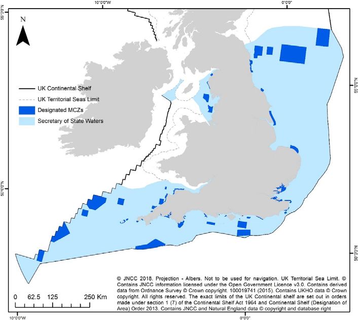
10.3 Following consultation, 27 MCZ sites, covering almost 10,000 km2 of seabed, were
designated in 2013 as the first tranche. In 2016, a second tranche of 23 MCZs were added
to the network, bringing the total area of protection to over 20,000 km2.
Figure 1 - Current MCZs in English and offshore Northern Irish waters
1311. Management of MPAs
11.1 To deliver conservation benefits, effective management of MPAs is crucial.
Managing commercial fishery activities in English waters in the 0-6 nautical miles zone is
the responsibility of the Inshore Fisheries and Conservation Authorities. The MMO is
responsible for licensing non-fisheries activities in all English waters and for fisheries
management in the 6-12 nautical miles and the 12-200 nautical miles (the English
Exclusive Economic Zone). These measures are being introduced through a risk-based,
phased approach to ensure the species and habitats most at risk from damaging activities
are protected first.
11.2 The regulators work with fisheries and other marine interests to make sure that
measures applied are proportionate and enable sites to meet their conservation
objectives. A number of sites already had some protection from fishing activities through
existing voluntary agreements. Since January 2016 all first tranche inshore sites have had
measures identified and work is ongoing to deliver measures for the second tranche sites.
This work includes the 26 SACs with marine features and 38 SPAs in the English inshore
zone. Examples of measures applied include: restricting the use of bottom towed mobile
gears over sensitive features through byelaws in all first tranche inshore sites; seasonal
restrictions on fisheries; and regional restrictions on the type and size of fishing gear used.
Voluntary agreements are used where appropriate and where good compliance can be
demonstrated. Offshore management measures must currently be agreed with other
Member States of the EU through the Common Fisheries Policy. All designated offshore
sites are either in negotiations now or are due to be consulted on very shortly. Defra is
seeking agreement to measures for five first tranche sites in the Southern North Sea and
ten MCZs in the Channel and South West. The MMO is currently consulting on measures
for West of Walney MCZ, a straddling site in the Irish Sea and will shortly be consulting on
measures for Fulmar MCZ and Farnes East MCZs in the North Sea. Examples of
measures proposed for offshore sites include restrictions on mobile bottom-towed gears
and seasonal restrictions on fisheries.
11.3 There are now 29 new and 25 legacy byelaws in place to provide specific protection
in inshore MPAs with a further 21 expected later in 2018. In addition, there are 15 new
voluntary agreements in place and two new Regulatory Orders. The government is
currently developing fisheries management measures for 9 offshore SACs with marine
features in the English offshore region and 2 offshore SPAs. These measures will primarily
protect harbour porpoise and sea birds.
11.4 Activities which require a marine licence, such as port developments, renewable
energy, oil and gas developments, which are within or in close proximity to an MCZ site,
are already managed through the existing marine licensing process. 19 The MCZ
assessment process is now embedded in the marine licensing process and the impact on
sites of potential new activities are assessed in line with legislative requirements.
19 https://www.gov.uk/government/publications/marine-conservation-zones-mczs-and-marine-licensing
1412. Highly Protected Marine Areas
12.1 As part of their work to identify suitable locations for MCZs, the Regional MCZ
Projects were asked to identify Reference Areas, also known as Highly Protected Marine
Areas (HPMAs). These are sites where greater restrictions on commercial or recreational
activities are likely to be needed. Reference areas were the most controversial aspect of
the Regional MCZ Projects’ recommendations. Subsequent scientific advice, from the
JNCC, Natural England and the independent Science Advisory Panel, was that most of
the recommendations were too small to be viable.
12.2 We asked the Centre for Environment, Fisheries and Aquaculture Science to carry
out a review of HPMAs 20. The aim of this review was to assess whether the added
conservation value of HPMAs, compared to other MPAs, would outweigh the additional
impacts they will have on sea users. Although their overall conclusion was that HPMAs
provide additional ecological value, the review found that they were not able to gain a
clear enough understanding of the extra economic costs of such sites. Without this, it is
difficult to justify the added restriction on sea users. The review also concluded that such
sites needed substantial stakeholder support to be successful and the Regional MCZ
Project experience suggested that this would be unlikely.
12.3 We would welcome any new evidence that would help establish whether the added
ecological benefits of HPMAs, beyond those of other MPAs, would outweigh the added
costs to sea users and for enforcement. We would also any views on locations where it
would be particularly beneficial for existing or new MPAs to have the higher level of
protection provided for by being a HPMA. This would not have any bearing on MCZs
designated in this tranche, but would be helpful for consideration of the future policy
development.
13. UK-wide picture
13.1 Each Administration in the UK has responsibility for designating MCZs in its inshore
waters (which extend to 12 nautical miles from the coast). Offshore waters adjacent to
England and Northern Ireland are the responsibility of the UK Government, while there is
executive devolution of responsibility to the Welsh and Scottish governments for offshore
waters adjacent to their countries.
13.2 All administrations are committed collectively to making an appropriate UK
contribution to the ecologically coherent network of MPAs in the North East Atlantic.
13.3 The UK has almost 300 MPAs established in our waters and almost 24% of UK
waters are currently protected in MPAs.
20 Cefas review of highly protected areas for Defra (2014/15). Available from:
http://randd.defra.gov.uk/Default.aspx?Menu=Menu&Module=More&Location=None&ProjectID=19469
1513.4 Please refer queries on MPAs in Scotland, Wales and Northern Ireland to the
relevant administration.
14. Scotland
14.1 In Scotland, MCZs are referred to as Nature Conservation MPAs. In 2014, thirty
Nature Conservation MPAs were designated for a wide range of habitats and species,
covering 10% of Scottish waters. In May 2017, Scottish Ministers designated the Loch
Carron MPA on an urgent basis, and are currently undertaking the statutory process
required to make it a permanent MPA. In addition to these 31 Nature Conservation MPAs,
Scottish Ministers are taking forward plans formally to consult in 2018 on four additional
proposals, primarily for mobile species such as basking shark and minke whale.
15. Wales
15.1 The Welsh Government is working towards completing its contribution to an
ecologically coherent UK network of MPAs. There are 134 MPAs in Welsh waters
protecting a wide range of marine habitats, species and birds.
15.2 An assessment undertaken by the JNCC and Natural Resources Wales in 2016
concluded Welsh MPAs are already making a substantial contribution towards ecologically
coherence and the wider network 21.
15.3 Later this year, work will begin to address the outcome of the network assessment
and the small number of gaps identified in the Welsh network. The Welsh Government
intends to work in partnership with marine stakeholders, Natural Resources Wales and the
JNCC to identify potential areas suitable for consideration as MCZs to fill the gaps.
15.4 The scale of the work will cover Welsh inshore and offshore waters to align with the
Welsh Government’s extended responsibility for nature conservation, as of 1 April 2018 22.
Further information regarding this work and its associated timeframe will be published by
the Welsh Government later this year.
21 http://jncc.defra.gov.uk/page-4164
22 The Wales Act, 2017, Subsection 46 to 47, Available from:
http://www.legislation.gov.uk/ukpga/2017/4/contents/enacted
1616. Northern Ireland
16.1 Following the introduction of the Marine Act (Northern Ireland) 2013, the
Department of Agriculture, Environment and Rural Affairs (DAERA) designated MCZs at
Rathlin, Waterfoot, Outer Belfast Lough and Carlingford Lough. Together with Strangford
Lough, this give a total of five MCZs in Northern Irish waters.
16.2 A network assessment undertaken by the JNCC concluded that following these
designations the current suite of MPAs in the Northern Ireland inshore region is very close
to delivering an ecologically coherent network. The majority of MPA features of
conservation interest are already represented and replicated in the MPA network. A small
number of features do not meet the benchmarks set by the network criteria but these
shortfalls typically only relate to replication or the amount of habitat afforded protection.
16.3 DAERA is currently considering the next steps to improve the coherence of the
network in line with the findings of the report and will focus on filling the identified gaps.
17Part D - MCZ third tranche: identifying sites
for designation
17.1 For the third tranche of MCZ designations, we are aiming to fill remaining gaps in
the network substantially to complete our contribution to the international ecologically
coherent network in the North East Atlantic. Filling gaps in our network means ensuring
our MPAs protect suitable proportions of all habitats and species in our waters.
17.2 Following the designation of the second tranche of MCZs, the JNCC carried out an
assessment of the progress made towards completing the network. This analysis identified
the remaining gaps that needed to be filled. The JNCC’s report 23 recommended that, in
addition to considering Regional MCZ Project sites (which form the bulk of the proposals
here) and adding additional features to existing MCZs, to fill the remaining gaps in the
network it would be necessary to identify a small number of new site options.
17.3 New site options were developed by the JNCC and Natural England to address the
remaining ecological gaps in the network while minimising any socioeconomic impacts on
sea users. The approach taken to identify potential new site options is set out in a
published report 24. Twelve candidate sites were identified and these were discussed with
stakeholders during the pre-consultation engagement period.
17.4 The JNCC and Natural England updated their scientific advice on the Regional
MCZ Project sites under consideration, incorporating data from surveys conducted in the
intervening period and any other new evidence. They also provided scientific advice on
the ecological importance and conservation objectives of the twelve new site options.
17.5 We engaged with local and national and, where appropriate, international
stakeholders to gather their views on the candidate sites. This included discussions with
representatives of all the main marine sectors and conservation charities that may have an
interest in the designation of sites.
17.6 We have reviewed each of the remaining Regional MCZ Project recommendations
(including features recommended for existing MCZs) and the new site options proposed
by the JNCC and Natural England, to identify those suitable to propose in this consultation
for designation in the third tranche. This consideration was based on:
23 JNCC 2016. Assessing progress towards an ecologically coherent MPA network in Secretary of State
Waters in 2016: Results:
http://jncc.defra.gov.uk/pdf/JNCC_NetworkProgressInSoSWaters2016_Results_Final.pdf
24 JNCC and Natural England 2016. Identifying potential site options to help complete the Marine Protected
Area network in the waters around England.
http://jncc.defra.gov.uk/pdf/Identifying_options_MPA_network_Final.pdf
18• Scientific advice on each site’s contribution towards completing the ecologically
coherent network.
• Adequacy of the supporting evidence on the presence and extent of the relevant
habitats and species in the site.
• Socioeconomic estimates of the impacts and costs of designation, including
consideration of concerns expressed by stakeholders.
18. Highly mobile species
18.1 We consider that sectoral measures applied over a wide area are likely to be the
most effective tools in conserving widely dispersed and highly mobile species such as fish,
birds and dolphins. These measures include fisheries quotas, ending wasteful discards,
by-catch mitigation measures and protected species licensing. However, MPAs do have a
role to play where highly mobile species are very dependent on specific areas or habitats,
for example, spawning or nursery grounds for fish, and seabird nesting colonies. Black
seabream and smelt are protected in two existing MCZs, harbour porpoise are protected
in designated SACs and there are now 107 SPAs protecting seabirds around the UK.
18.2 Defra invited proposals for sites where there was clear evidence that an MCZ would
provide effective protection for a highly mobile species. The JNCC and Natural England
developed principles for identifying the suitability of MCZ protection for a highly mobile
species and provided guidance to assist those proposing suitable sites 25.
18.3 Twenty-one proposals were received, covering seabirds, fish species and white-
beaked dolphin. The scientific case and socioeconomic costs and benefits of each
proposal were assessed to identify those suitable to propose for designation in this
consultation, particularly considering if there was clear evidence that the conservation of
the highly mobile species would benefit from site-based protection measures in that
location.
18.4 Other stakeholders have not yet had the opportunity to comment on the sites we
are proposing for designation and we welcome views and any additional evidence that
stakeholders wish to submit during the consultation.
25 JNCC and Natural England 2016b. Identifying possible Marine Conservation Zones for highly mobile
species: Principles for third-party proposals.
http://jncc.defra.gov.uk/pdf/20160525_AnnexA_Selection_criteria_proposed_by_JNCC_and_Natural_Englan
d_v4.0.pdf
19Part E - MCZ third tranche proposals
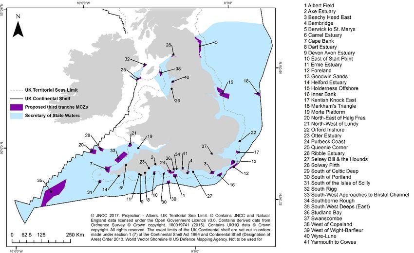
19.1 Forty-one sites are proposed for designation in the third tranche. Details of these
sites are provided in Table 1 below and further information is available in site factsheets.
The areas of the sites have been rounded to the nearest whole kilometre. A map of all
proposed sites is below in Figure 2.
Table 1 – Third tranche MCZs
Proposed MCZ Site number on map Inshore/offshore Area (km2)
Albert Field 1 Inshore 192
Axe Estuary 2 Inshore 1
Beachy Head East 3 Inshore 195
Bembridge 4 Inshore 75
Berwick to St. Mary’s 5 Inshore 634
Camel Estuary 6 Inshore 2
Cape Bank 7 Inshore & offshore 474
Dart Estuary 8 Inshore 5
Devon Avon Estuary 9 Inshore 2
East of Start Point 10 Inshore & offshore 116
Erme Estuary 11 Inshore 1
Foreland 12 Inshore 244
Goodwin Sands 13 Inshore 277
Helford Estuary 14 Inshore 6
Holderness Offshore 15 Inshore & offshore 1176
Inner Bank 16 Inshore & offshore 199
Kentish Knock East 17 Inshore & offshore 96
Markhams’s Triangle 18 Offshore 200
Morte Platform 19 Inshore 25
North-East of Haig Fras 20 Offshore 464
North-West of Lundy 21 Inshore 173
Orford Inshore 22 Inshore & offshore 72
Otter Estuary 23 Inshore 1
Purbeck Coast 24 Inshore 282
Queenie Corner 25 Offshore 146
Ribble Estuary 26 Inshore 15
Selsey Bill & the Hounds 27 Inshore 16
Solway Firth 28 Inshore 45
South of Celtic Deep 29 Offshore 278
South of Portland 30 Inshore 17
South of the Isles of Scilly 31 Offshore 132
South Rigg 32 Offshore 143
South West Approaches to 33 Inshore & offshore
Bristol Channel 1128
20Southbourne Rough 34 Inshore 5
South West Deeps (East) 35 Offshore 4653
Studland Bay 36 Inshore 4
Swanscombe 37 Inshore 3
West of Copeland 38 Offshore 158
West of Wight-Barfleur 39 Offshore 138
Wyre-Lune 40 Inshore 92
Yarmouth to Cowes 41 Inshore 16
19.2 Regional MCZ Project sites make up the bulk of the third tranche proposals (30
sites), alongside nine new site options and two sites to be designated for the protection of
highly mobile species only. Details of all the features proposed for protection in all sites
are provided in site factsheets.
19.3 The two new highly mobile species sites will protect common eider (Berwick to St.
Mary’s) and black seabream (Southbourne Rough). Additionally we are proposing to
protect black seabream as a feature of the new Purbeck Coast site and as an additional
feature of the existing Poole Rocks MCZ, and razorbill as an additional feature of the
existing Cumbria Coast MCZ.
20. Residual ecological gaps
20.1 If all of the sites and features proposed for the third tranche are designated, our
contribution to the international ecologically coherent network of MPAs will be substantially
complete. Some residual ecological gaps will remain but we believe that for the most part
these are not particularly significant. The most significant residual gap will be for seabed
mud habitats in the English Channel. We have, as yet, not been able to find more suitable
sites for this habitat in the region due to limitations of the data for mud in the region and
the very significant socioeconomic implications of some locations considered. The other
residual gaps are minor, either a small shortfall in the proportion of habitat being protected
or in the number of MCZs in which the feature is protected.
20.2 Residual gaps will be considered further with later designations of individual sites.
As new scientific evidence emerges there may also be need to make future changes by
adding or adapting individual sites. We would welcome any new scientific evidence that
may help us identify potential sites to fill these gaps in individual designations after this
third tranche.
2121. Overview of new sites proposed for designation
Figure 2 – Proposed new MCZs in English and offshore Northern Irish waters
21.1 Thirty-nine of the sites proposed are in English waters and two are in Northern Irish
offshore waters. The total area covered by the new sites is 11,713 km2: 3,441km2 in the
inshore area and 8,272 km2 in the offshore area. 201 features will be covered, including
features to be added to existing sites.
21.2 Following analysis of scientific and socioeconomic evidence for each site and
discussions with stakeholders, the boundaries of nine sites have been revised from those
recommended by the Regional MCZ Projects. Boundary changes have been made to
address concerns about specific potential impacts on sea users without significantly
reducing the ecological value of the sites. Boundaries have also been changed to capture
the extent of ecologically important features better. In most cases these boundary
changes have been very minor. The sites affected are Axe Estuary, Bembridge, Camel
Estuary, Ribble Estuary, Selsey Bill and the Hounds, South of Celtic Deep, South West
Deeps (East), Swanscombe, Yarmouth to Cowes and Wyre-Lune. Additionally, the
boundaries for two of the highly mobile species sites have changed from the proposals
submitted. There was a minor change for Cumbria Coast, and a significant extension to
the Coquet Island proposal to include a greater area used by eider ducks for foraging in
the nesting season. In light of the significant amendment to the Coquet Island proposal the
site name has also been changed to Berwick to St. Mary’s to better reflect the location of
the site. Details of the boundaries for each site are provided site factsheets.
21.3 Our MPA network will protect the full range of habitats and species that live in our
seas, some of which are rare and vulnerable. The sites proposed in the third tranche
22protect a diverse range of important habitats, marine life and features of geological
importance. These include 126 broad-scale habitats, 33 species of conservation
importance and seven of geological importance.
21.4 Each broad-scale habitat represents habitats, and the associated species that live
on and in the habitat, at a relatively coarse level, e.g. “subtidal mud” covers all mud
sediment seabed conditions which support a variety of marine life, such as large numbers
of worms, brittle stars, bivalves, urchins, nephrops, burrowing mega-fauna and sea-pens.
These broad habitat types act as surrogates for biodiversity at finer scales. The broad-
scale habitats cover a variety of depths within UK waters, and range from finer mud
sediments to sandy seabeds to coarse gravels and hard substrate such as bedrock, each
supporting a range of species. By protecting a wide range of habitats in different physical
and geographic conditions, the network will support a range of different species that rely
on these.
21.5 Habitats and species of conservation importance are specific species and habitats
that are known to be rare, threatened or declining in our seas. They are considered in
addition to broad-scale habitats to identify where urgent action may be required for their
conservation. An example of a habitat of conservation importance is subtidal biogenic
reefs such as ross worm reefs, which provide a secure environment for other marine life
such as anemones, snails and seaweeds. Other habitats of conservation importance
include seagrass beds which can provide a nursery area or shelter for fish species
including seahorses, unique and fragile peat and clay exposures and diverse seapen and
burrowing megafauna communities.
21.6 Species of conservation importance protected in sites in this consultation include
species known to be rare, threatened or declining in our seas. Examples include short
snouted seahorse, three species of stalked jellyfish, fan mussel, and peacock's tail
seaweed.
21.7 Our aim is to have sufficient representation in our MPA network of these different
types of habitats and species. For broad-scale habitats this is achieved through protecting
a target percentage of each in all the biogeographic regions in which they occur. For
habitats and species of conservation importance our aim is to have three replicates of
each protected in each region in which they occur. Further information on these ecological
targets is provided in Natural England and the JNCC’s Ecological Network Guidance 26.
21.8 The conservation objective for features protected by MCZs is that each of the
features be in favourable condition. To achieve this objective, the general management
approach required will either be for it to be maintained in favourable condition (if it is
currently in this state), or for it to be recovered to favourable condition (if it is currently in a
damaged state) and then to be maintained in favourable condition 27.
21.9 Details of the habitats and species in each of these sites are in site factsheets.
26 http://jncc.defra.gov.uk/pdf/100705_ENG_v10.pdf and
https://assets.publishing.service.gov.uk/government/uploads/system/uploads/attachment_data/file/492784/m
cz-update-jan-2016.pdf
27 https://www.gov.uk/government/uploads/system/uploads/attachment_data/file/259972/pb14078-mcz-
explanatory-note.pdf
23You can also read