On the Duality of Marine Geoheritage: Evidence from the Abrau Area of the Russian Black Sea Coast
←
→
Page content transcription
If your browser does not render page correctly, please read the page content below
Journal of
               Marine Science
               and Engineering

Communication
On the Duality of Marine Geoheritage: Evidence from the
Abrau Area of the Russian Black Sea Coast
Dmitry A. Ruban

                                          K.G. Razumovsky Moscow State University of Technologies and Management (The First Cossack University),
                                          Zemlyanoy Val Street 73, 109004 Moscow, Russia; ruban-d@mail.ru

                                          Abstract: Marine geoheritage is an important but still underdeveloped concept. Field investigations
                                          in the Abrau area (Krasnodar Region, southwestern Russia) and subsequent interpretations allow for
                                          the characterization of its geoheritage. Two geosites, namely Abrau and Limanchik, are delineated
                                          and assessed semi-qualitatively. Their high heritage value, complexity, and appropriate “technical”
                                          properties are appraised. The Abrau geosite features Abrau Lake with its enigmatic origin and the
                                          outcrops of deformed Upper Cretaceous carbonate flysch deposits. The Limanchik geosite represents
                                          an outstanding example of coastal abrasion, Paleocene siliciclastic flysch with trace fossils, and a
                                          coastal lagoon separated from the sea by a bar. The heritage aspects of the study areas are related
                                          to the development of the Late Cretaceous, Paleocene, and Pliocene seas, as well as to the active
                                          dynamics of the Black Sea coastal zone. The duality of marine geoheritage is linked to its relation to
                                          both ancient and modern marine environments.

                                          Keywords: coastal zone; deep-marine setting; geosites; Paleocene; Northwestern Caucasus


Citation: Ruban, D.A. On the              1. Introduction
Duality of Marine Geoheritage:                 Investigations of geological and geomorphological heritage (geoheritage) have become
Evidence from the Abrau Area of the       an important direction of research among international geosciences, with an accumulation
Russian Black Sea Coast. J. Mar. Sci.
                                          of significant amounts of diverse knowledge [1–7]. However, many particular aspects
Eng. 2021, 9, 921. https://doi.org/
                                          of geoheritage are yet to be fully understood. One of them is the concept of marine
10.3390/jmse9090921
                                          geoheritage—a category which sounds particularly evident, but too vague. Coratza et al. [8]
                                          and Rovere et al. [9] focused on underwater geoheritage. Li et al. [10] demonstrated
Academic Editor: Gary Wilson
                                          the relevance of geoheritage to marine parks. According to Gutak et al. [11], marine
                                          geoheritage comprises unique features linked to dynamics, and thus geological forces of
Received: 5 August 2021
Accepted: 24 August 2021
                                          ancient and modern oceans and seas. Additionally, Chiba et al. [12], Peng et al. [13], and
Published: 24 August 2021
                                          Vescovo et al. [14] paid attention to pollution, waste accumulation, and related conservation
                                          in the Mariana Trench, which seems to be a global geoheritage feature due to its outstanding
Publisher’s Note: MDPI stays neutral
                                          depth. Generally, it appears that more evidence from various (terrestrial, coastal, and
with regard to jurisdictional claims in
                                          submarine) localities is necessary to further develop the concept of marine geoheritage.
published maps and institutional affil-        The Abrau area in the southwestern part of Russia hosts several notable manifesta-
iations.                                  tions, which contribute to the understanding of marine geoheritage. This area represents
                                          the Black Sea coast along the Northwestern Caucasus. It belongs to a nationally important
                                          tourist destination and boasts both natural [15–17] and cultural [18,19] heritage. Aspects
                                          of the Abrau area’s geoheritatge have already been reported by Baraboshkin et al. [20],
Copyright: © 2021 by the author.
                                          Karpunin et al. [21], and Ruban [22], but without any in-depth assessment. Nonetheless,
Licensee MDPI, Basel, Switzerland.
                                          these preliminary studies have prepared the way to establish a better framework for subse-
This article is an open access article
                                          quent investigations. The outcomes of the field studies aimed at a geoheritage inventory
distributed under the terms and           for the Abrau area help to characterize related features. Not only general descriptions,
conditions of the Creative Commons        but semi-quantitative assessment is also possible. The outcomes of these new studies also
Attribution (CC BY) license (https://     provide valuable information for discussion of the concept of marine geoheritage. The
creativecommons.org/licenses/by/          objective of the present paper is to give the first systematic characteristics of the Abrau
4.0/).                                    area’s geoheritage, with a focus on its most important manifestations, namely geoheritage

J. Mar. Sci. Eng. 2021, 9, 921. https://doi.org/10.3390/jmse9090921                                         https://www.mdpi.com/journal/jmse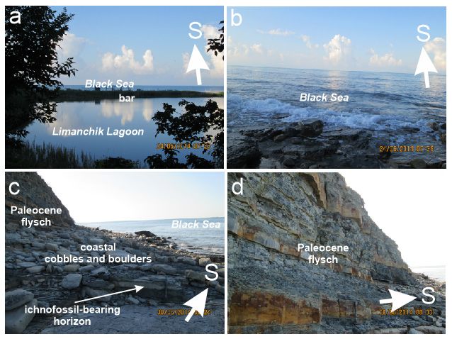
J. Mar. Sci. Eng. 2021, 9, x FOR PEER REVIEW 2 of 14
these new studies also provide valuable information for discussion of the concept of ma-
J. Mar. Sci. Eng. 2021, 9, 921 rine geoheritage. The objective of the present paper is to give the first systematic charac- 2 of 14
teristics of the Abrau area’s geoheritage, with a focus on its most important manifesta-
tions, namely geoheritage sites (geosites) and their relevance to the concept of marine
geoheritage. More
sites (geosites) andgenerally, this paper
their relevance to themakes a contribution
concept to the literature
of marine geoheritage. Moreby empha-
generally,
sizing marine
this paper geoheritage
makes as a specific
a contribution geoheritage
to the literature category, which
by emphasizing is highly
marine important,
geoheritage as a
but still poorly conceptualized. The Abrau area is used as a reference locality for testing
specific geoheritage category, which is highly important, but still poorly conceptualized.
the related
The Abrau ideas
area isand
usedmethods.
as a reference locality for testing the related ideas and methods.
2. Geological Setting
The study area is located on the northeastern coast of the Black Sea bordering bordering the
northwestern
northwestern edge of the Greater Caucasus mountain chain (Figure 1a). The latter is a
late Cenozoic orogen, the origin of which is related to a collision between the much larger
Eurasian lithospheric
lithosphericplate
platetoto
thethe north
north andand the smaller
the smaller Arabian
Arabian plate inplate in the[23–27].
the south south
MesozoicMesozoic
[23–27]. and Cenozoic sedimentary
and Cenozoic packagespackages
sedimentary crop out crop
widely
outthere,
widelyandthere,
theseand
are often
these
deformed
are due to ongoing
often deformed due toorogenesis and earlier
ongoing orogenesis phases
and of phases
earlier tectonicofactivity.
tectonicThese packages
activity. These
formed informed
packages a seriesinofaback-arc
series ofbasins (Figure
back-arc basins1b), which1b),
(Figure evolved
whichon the wide
evolved on northern
the wide
periphery of the Neo-Tethys Ocean until its final re-organization [23,26–28].
northern periphery of the Neo-Tethys Ocean until its final re-organization [23,26–28].
Figure 1. Location of the study area and the principal tectonic elements: (a)—present, (b)—Late Cretaceous (partly based
Figure
on 1. Location of
the information the[28]).
from study area and the principal tectonic elements: (a)—present, (b)—Late Cretaceous (partly based
on the information from [28]).
The Abrau area is a mountainous domain with elevations up to 500 m above sea
level.The
It isAbrau
situated area
westis of
a mountainous
the large city of domain with elevations
Novorossiysk up to
(Figure 1a). 500 m above sea
Administratively, it
level.
belongsIt is
to situated west ofRegion
the Krasnodar the large city
of the of Novorossiysk
Russian Federation.(Figure 1a). Administratively,
The characteristic geographical it
belongs to the Krasnodar Region of the Russian Federation. The
elements consist of Abrau Lake and the Black Sea coastal zone (Figure 2). Its northern part characteristic geo-
graphical
is occupied elements consistzone
by the urban of Abrau Lake and theand
of Abrau-Dyurso, Black
its Sea coastal
central and zone
southern(Figure
parts2).are
Its
northern part is occupied
actively exploited by the ofurban
for the purposes tourismzoneandofoutdoor
Abrau-Dyurso,
recreation, and
withitsmany
central and
related
southern parts arelodges,
facilities (camps, actively exploited
etc.). The slopesfor the purposes
of short of tourism
mountain rangesand
areoutdoor
coveredrecreation,
by forests
or used
with many for related
the purposes of the
facilities winelodges,
(camps, and recreation
etc.). The industries.
slopes of short mountain ranges are
Theby
covered local geology
forests is reviewed
or used by Baraboshkin
for the purposes of the wineet al.and
[20], Kropotkin
recreation [29], Ruban [22],
industries.
and Trikhunkov et al. [30,31]. The Abrau area occupies the
The local geology is reviewed by Baraboshkin et al. [20], Kropotkin [29], southwestern periphery
Rubanof[22],the
Northwestern
and Trikhunkov Caucasus, whichThe
et al. [30,31]. is the edgearea
Abrau of the Greaterthe
occupies Caucasus orogen.periphery
southwestern It is dominated
of the
by flysch deposits,
Northwestern namelywhich
Caucasus, UpperisCretaceous
the edge of (Campanian–Maastrichtian)
the Greater Caucasus orogen. carbonate flysch
It is domi-
with
natedalternating
by flysch limestones,
deposits, namelymarlstones,
Upper sandstones,
Cretaceous and siltstones (the total thickness
(Campanian–Maastrichtian) is
car-
>2000
bonatem), andwith
flysch Paleocene (Selandian–Thanetian)
alternating limestones, marlstones, siliciclastic flysch with
sandstones, alternating
and siltstones sand-
(the to-
stones,
tal siltstones,
thickness andm),
is >2000 rareand
marlstones
Paleocene (the total thickness is >1000
(Selandian–Thanetian) m) [20,22].
siliciclastic flysch Upper
with
Cretaceous carbonate flysch dominates the northeastern half
alternating sandstones, siltstones, and rare marlstones (the total thickness is >1000of the study area, and Pale-
m)
ocene siliciclastic
[20,22]. flysch forms
Upper Cretaceous its southwestern
carbonate part (Figure
flysch dominates 2). All deposits
the northeastern half ofarethe
strongly
study
distorted by tectonic forces, often exhibiting high-angle dipping. These deposits are ex-
posed in small tectonic blocks between numerous late Cenozoic faults trending from the
northwest to the southeast. The regional plate tectonic reconstructions [28] imply that both
flysch packages formed in the central part of the same Western Caucasian Flysch Basin,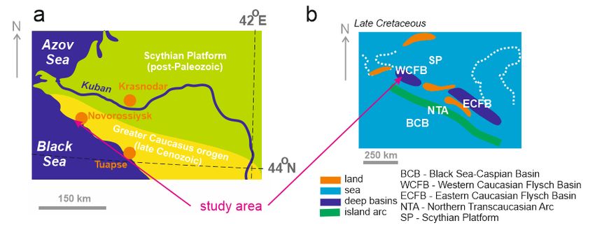
1b). This basin was relatively small, and it occupied the western part of the present oro-
gen between the Northern Transcaucasian Arc in the south and the Scythian Platform
(the southern element of the Russian Platform) in the north. This basin subsided actively,
and it was rather deep (up to 3 km). It was occupied by a semi-enclosed, marginal Cau-
J. Mar. Sci. Eng. 2021, 9, 921 3 of 14
casian Sea, which was warm (tropical conditions), with normal salinity, and populated
by abundant marine invertebrates [32]. Marine life is evident from trace fossils reported
locally from the Upper Cretaceous [20] and the Paleocene [22]. The Creta-
which evolved through
ceous–Paleogene the Late
transition is Cretaceous–Paleocene
marked by a hiatus [20], (Figure 1b). This
which can basin was rela-by a
be explained
tively small, episode
short-term and it occupied the western
of tectonic part
uplift. In theofsecond
the present
half orogen between the
of the Cenozoic, theNorthern
uplift of the
Transcaucasian Arc in the south and the Scythian Platform (the southern
Greater Caucasus and some other mountain chains in the neighboring domains element of resulted
the
Russian Platform) in the north. This basin subsided actively, and it was rather
in the development of the Paratethys Sea with a complex configuration; this sea existeddeep (up to
3until
km).the
It was occupied by a semi-enclosed, marginal Caucasian Sea, which was warm
very end of the Cenozoic, including the Pliocene, and the modern Azov, Black, (trop-
ical conditions), with normal salinity, and populated by abundant marine invertebrates [32].
and Caspian seas can be judged its remnants [33–36].
Marine life is evident from trace fossils reported locally from the Upper Cretaceous [20]
and the Paleocene [22]. The Cretaceous–Paleogene transition is marked by a hiatus [20],
3. Methodology
which can be explained by a short-term episode of tectonic uplift. In the second half of
The present
the Cenozoic, studyof
the uplift is the
based on field
Greater investigations
Caucasus and some inother
the Abrau areachains
mountain with subsequent
in the
interpretations
neighboring of observations,
domains resulted in the descriptions,
developmentand photographs.
of the The
Paratethys Sea original
with field re-
a complex
search and thethis
configuration; earlier preliminary
sea existed studies
until the [20–22]
very end contributed
of the to the establishment
Cenozoic, including of the
the Pliocene,
and the and
Abrau modern Azov, Black,
Limanchik and(Figure
geosites Caspian2).
seas can be judged its remnants [33–36].
Figure2.2.The
Figure TheAbrau
Abrauarea
area and
and itsits geosites.
geosites.
3. Methodology
Geoheritage studies balance methodologically between natural and social sciences.
The presentneed
These studies studynot
is based
only on field investigations
fact-based judgmentsinandthe semi-quantitative
Abrau area with subsequent
analyses, but
interpretations of observations, descriptions, and photographs.
also qualitative (even philosophical) interpretations and individualThe original field research
researchers’ vision.
and theapproaches
These earlier preliminary
are mixedstudies [20–22]
because contributed
geoheritage isto
a the
bothestablishment of the
objective (real Abrau ob-
geological
and Limanchik
jects) geosites
and subjective (Figure 2).
(people’s interpretation of these objects). The present study follows
Geoheritage studies balance methodologically between natural and social sciences.
the basic principles of the “standard” geoheritage-related studies, the outcomes of which
These studies need not only fact-based judgments and semi-quantitative analyses, but
are published in professional international journals (for instance, [37–39]).
also qualitative (even philosophical) interpretations and individual researchers’ vision.
From various methods of geosite-based geoheritage assessment [40–43], the new
These approaches are mixed because geoheritage is a both objective (real geological objects)
approach by Ruban
and subjective et interpretation
(people’s al. [44] was employed. To avoid
of these objects). Therepetitions from
present study the previous
follows the
basic principles of the “standard” geoheritage-related studies, the outcomes of which are
published in professional international journals (for instance, [37–39]).
From various methods of geosite-based geoheritage assessment [40–43], the new
approach by Ruban et al. [44] was employed. To avoid repetitions from the previous
work, this method is explained below only briefly. Nonetheless, the novelty and the
innovativeness of this method should be stressed, as it differs from the approaches proposed
earlier [7,40–43]. This method aims at being more comprehensive, less subjective, and
independent from national (cultural, economical, etc.) contexts, particular situations, and
regional traditions of geoconservation experience. It has previously been employed only
once (and in an extremely different situation) [44], and thus, to deserve wide application, it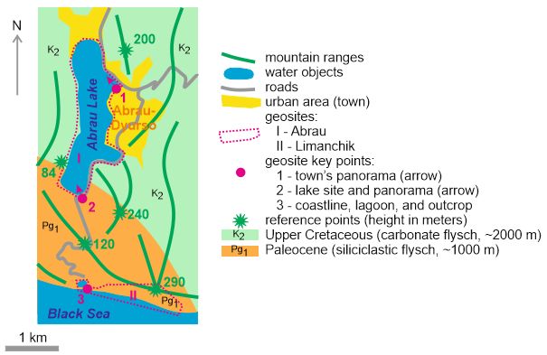
J. Mar. Sci. Eng. 2021, 9, 921                                                                                             4 of 14

                                 needs testing in several reference localities from the different part of the world. Moreover,
                                 its suitability to documenting marine geoheritage is documented.
                                        Each geosite is examined to underscore its uniqueness. The uniqueness is defined as a
                                 spatial rarity of particular features (this may be physical rarity, but also rare possibilities
                                 for studying any particular phenomenon, its standardization, or teaching any aspect of
                                 the Earth’s evolution). For instance, if a given mineral is found in the only locality of the
                                 country, but it is known from many localities of the other countries, its national uniqueness
                                 is amplified. Similarly, if the only section from the given region represents any particular
                                 episode of the geological history, but similar sections are available in the other regions, this
                                 is example of regional uniqueness. When a given geosite includes two and more notable
                                 features, the uniqueness is established for each of them and the uniqueness of the entire
                                 geosite is equal to the biggest uniqueness of its features. Evidently, such a basic valuation
                                 requires perfect geological and/or geomorphological inventories of geosites. Undoubtedly,
                                 uniqueness is an essential category for understanding and valuing geoheritage, although
                                 it is rather subjective (it depends on our current geological knowledge, society attitude
                                 to geoheritage, and the researcher’s ability to argue higher or lower value of a particular
                                 feature). Nonetheless, its analysis can be undertaken objectively via documenting the
                                 relative distribution of the particular class of potentially unique features. In this study,
                                 the uniqueness is treated in three steps. First, descriptions of potentially unique features
                                 found in the Abrau area are provided. Second, the spatial rarity of these features is checked
                                 in qualitative manner. Third, this information is tabulated for better, scientifically sound
                                 representation in order to facilitate establishing scores specified in Table 1.
                                        The other, “technical” (“supplementary”) geosite properties of geosites are also doc-
                                 umented. These may either increase or decrease the basic geoheritage value. A scoring
                                 system has been proposed to take these properties into account and to assess geosites
                                 semi-quantitatively (Table 1). In rare cases, the “technical” properties can increase or
                                 decrease the geosite’s value so much as to shift it to a higher or lower rank, respectively. In
                                 any case, geosites with a higher total score are more valuable than the others. Judgments
                                 on aesthetic properties are always difficult and highly subjective. For the purposes of
                                 the present study, some basic ideas offering the broad understanding of these properties
                                 and their relevance to geoheritage [45–47] are applied. In particular, the aesthetics are not
                                 restricted to only color properties or availability of spectacular views, but these also refer
                                 to sounds, openness, identity, etc.
                                        Each geosite within the Abrau area is delineated to embrace the plot occupied by
                                 the related features. Justification of this task is facilitated by employing satellite images
                                 from the “Google Earth”. As these geosites are rather large, their key points, which are
                                 ideal for visiting, observing, and understanding their heritage, are specified on the basis
                                 of the observations in the course of field investigations. The idea of such points has been
                                 introduced, particularly, by Ruban et al. [48]. Landscape panoramas are essential for the
                                 comprehension of geoheritage, and thus, viewpoints (sensu [49–53]) are distinguished
                                 within the above-mentioned key points.
J. Mar. Sci. Eng. 2021, 9, 921 5 of 14
Table 1. Criteria of geosite assessment (based on [44]).
Criteria (Properties) Subdivisions Scores
Basic valuation
Global (planetary) +500
National (country-scale) +250
Rank/Uniqueness
Regional (provincial) +100
Local (area-restricted) +50
Amendments depending on “technical” properties
>10 +50
4–10 +25
Number of geoheritage types
2–3 +10
1 0
Easy in populated area +25
Accessibility Easy in remote area 0
Difficult –25
No danger +25
Potential danger 0
Vulnerability
Partly damaged –25
Fully destroyed –50
Absent +25
Basic geological knowledge required 0
Need for interpretation
Professional geological knowledge required –10
Scientific analysis required –25
International +25
Scientific importance
Local 0
International +25
Educational importance
Local 0
International +25
Touristic importance
Local 0
High +50
Aesthetic properties Medium +25
Low 0
4. Results
4.1. The Abrau Geosite
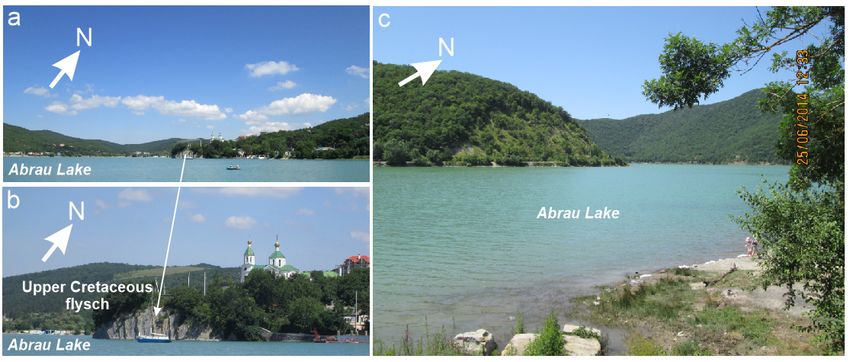
The Abrau geosite is congruent with Abrau Lake (Figure 3), which dominates the
northern part of the study area (Figure 2). This elongated lake has a length of ~2.6 km, width
of ~600 m, depth of ~10 m, and area of ~1.6 km2 [20]. It is one of the biggest lakes of the
Northwestern Caucasus, and its geological uniqueness is linked, first of all, to its enigmatic
origin. Two hypotheses have been proposed [20] and are both highly popular among both
tourist guides and experts. On the one hand, it is possible that the former valley of a small
river was dammed by a giant landslide, which may have been triggered by seismic activity
along a local fault system. This hypothesis is generally plausible, but one should note
the presence of mountain ranges to the south of the lake, which surround the latter and
are larger than any natural dam. On the other hand, this lake could be a remnant of the
former Pliocene marine basin, which was separated by uplifted ranges. This hypothesis is
supported by the presence of not only freshwater, but also a brackish water ichthyofauna
in the modern lake [20]. Nonetheless, there may be alternative explanations of how fish
could populate the lake (for instance, bird transport cannot be excluded). Additionally, one
should note the presence of a spectacular outcrop of Upper Cretaceous flysch on the lake’s
northern shore (Figure 3a). These rocks exhibit rhythmic accumulation of carbonates in the
deep Western Caucasian Flysch Basin during the Campanian–Maastrichtian (Figure 1b).
This sedimentary package experienced significant tectonic stress (probably related to the=> National uniqueness phe of the Past
Widely distributed in the NW Caucasus out-
Record of deep marine basin of
Outcrops of Upper Cretaceous side the study area (although this may be the
Campanian–Maastrichtian age with
carbonate flysch only lakeshore exposure)
rhythmic sedimentation
=> Local uniqueness
J. Mar. Sci. Eng. 2021, 9, 921 6 of 14
Widely distributed in the NW Caucasus out- Cenozoic tectonic deformations
Tectonic deformations side the study area linked, probably, to the orogen
=> Local uniqueness growth
late Cenozoic
Enigmaticorogeny),
lake–seaand the rocksindemonstrate
relationships a pattern
the late Cenozoic of of
history almost vertical
a growing dipping
orogen
(Figure
A single, most important reason 3b). object
to (this Thesedemonstrates
qualitative descriptions
complexitiesform basis for judgments
of near-marine of spatial
lake formation due torarity of the
various
potentially
judge the entire object unique unique
possible features
geological of the
forces Abrau
in the geosite
uplifted (Table
areas 2). Some
and pitfalls related explanations
of scientists to solve the are
also provided
problembelow,
of laketogether
origin; nowith the geoheritage
analogues in Russia)type characteristics.
Figure
Figure 3. The
3. The Abrau
Abrau geosite:
geosite: (a,b)—viewsfrom
(a,b)—views fromthe
the town’s
town’s promenade
promenade lakefront,
lakefront,(c)—panoramic view
(c)—panoramic from
view thethe
from southern
southern
coast.
coast. Arrows
Arrows indicate
indicate views
views towardsnorth.
towards north.
The Abrau geosite can be assigned to three geoheritage types (Table 3) related to the
Table 2. Features of the Abrau geosite.
potentially unique features (Table 2). Although the flysch outcrop indicative of the local
Late Cretaceous palaeogeography and the Occurrence
Spatial Cenozoic tectonic
of deformations is of only local
importance Features
due to the availability of Similar
the similar objects on the State areas
adjacent of Uniqueness
(e.g., [20]),
Features
the lake itself represents a hydro(geo)global phenomenon, which is rare on a coun-
The only lake in Russia with Specific geographical setting,
try-wide scale [21]. The debatable origin of the lake, involving catastrophic scenarios,
such hypothesized relations to debated origin, possible
Abrau
contributes Lake
to its uniqueness. The
thehighest rank is national, and geological
nearby sea thus the entire geositeofcan
catastrophe the
be judged to be of national value. The latter is not
=> National uniqueness challenged by
Past “technical” properties
(Table 4). Although this geosite boasts only three geoheritage types, it is highly accessible
Widely distributed in the NW
Record of deep marine basin
Caucasus outside the study
Outcrops of Upper Cretaceous of Campanian–Maastrichtian
area (although this may be the
carbonate flysch age with rhythmic
only lakeshore exposure)
sedimentation
=> Local uniqueness
Widely distributed in the NW
Cenozoic tectonic
Caucasus outside the study
Tectonic deformations deformations linked, probably,
area
to the orogen growth
=> Local uniqueness
Enigmatic lake–sea relationships in the late Cenozoic history of
A single, most important a growing orogen (this object demonstrates complexities of
reason to judge the entire near-marine lake formation due to various possible geological
object unique forces in the uplifted areas and pitfalls of scientists to solve the
problem of lake origin; no analogues in Russia)
The Abrau geosite can be assigned to three geoheritage types (Table 3) related to
the potentially unique features (Table 2). Although the flysch outcrop indicative of the
local Late Cretaceous palaeogeography and the Cenozoic tectonic deformations is of
only local importance due to the availability of the similar objects on the adjacent areas
(e.g., [20]), the lake itself represents a hydro(geo)global phenomenon, which is rare on a
country-wide scale [21]. The debatable origin of the lake, involving catastrophic scenarios,
contributes to its uniqueness. The highest rank is national, and thus the entire geosite canJ. Mar. Sci. Eng. 2021, 9, 921 7 of 14
be judged to be of national value. The latter is not challenged by “technical” properties
(Table 4). Although this geosite boasts only three geoheritage types, it is highly accessible
because a road stretches along its eastern coast (Figure 2). Vulnerability of this geosite
is linked to the possible fall in lake level due to anthropogenically induced changes in
the water balance in an actively exploited recreational zone. A negative factor is the
need for professional interpretation—ordinary visitors without geological knowledge and
additional explanations will see the only a beautiful lake, whereas their attention should be
turned to its enigmatic origin and the above-mentioned scenarios. Although Abrau Lake
serves chiefly for local research, education, and tourism, it boasts exceptional aesthetic
properties due to spectacular panoramic views (Figure 3a,c), clean water, and the sound
of solitude.
Table 3. Geoheritage types in the geosites of the Abrau area (see text for details).
Geosites (Rank/Uniqueness Is Indicated)
Geoheritage Type
Abrau Limanchik
Stratigraphical - Local
Palaeogeographical Local (MA) National (MA)
Tectonic Local Local
Sedimentary - Regional (MA)
Geomorphological - Local (MP)
Engineering - Local
Hydro(geo)logical National (MA) Local (MP)
3 types, the highest 7 types, the highest
TOTAL
rank—national rank—national
Note: the relations to the ancient marine (MA) and present marine (MP) environments are marked.
Table 4. Scoring the geosites of the Abrau area (see text for details).
Geosites
Criteria
Abrau Limanchik
Rank/uniqueness +250 +250
Number of geoheritage types +10 +25
Accessibility +25 +25
Vulnerability 0 +25
Need for interpretation –10 –10
Scientific importance 0 0
Educational importance 0 0
Touristic importance 0 0
Aesthetic properties +50 +25
325 340
TOTAL
(National rank not changed) (National rank not changed)
The Abrau geosite is relatively large, and its limits coincide generally with the coastline
of Abrau Lake (Figure 2). Two key points can be proposed. The first of them is located
on the wide promenade lakefront of Abrau-Dyurso (Figure 2). It offers a panoramic view
of the northern part of Abrau Lake (Figure 3a) and, particularly, the outcrop of Upper
Cretaceous carbonate flysch (Figure 3b), i.e., it allows an enjoyment of all geoheritage
types of this geosite. The second key location is at the very southern edge of the lake
(Figure 2), from where a spectacular panorama of the lake and the surrounding mountain
ranges can be viewed from the road (visitors can also stay on a narrow lake shore or even
swim in the lake) (Figure 3c). Both of these proposed key spots are essentially viewpoints
(sensu [50,52]).J. Mar. Sci. Eng. 2021, 9, 921 8 of 14
4.2. The Limanchik Geosite
The Limanchik geosite corresponds to the Black Sea coast in the southern part of the
study area (Figure 2). It embraces a narrow (usuallyJ. Mar. Sci. Eng. 2021, 9, 921 9 of 14
Table 5. Features of the Limanchik geosite.
Features Spatial Occurrence of Similar Features State of Uniqueness
Local record of deep marine basin of
The study area provides the best record
Paleocene age with turbidite
of the Paleocene deposits in the NW
sedimentation
Outcrops of Paleocene siliciclastic flysch Caucasus, similar deposits may be found
in the other, remote regions of Russia Local Paleocene reference section
=> Local to regional uniqueness
Regional occurrence of siliciclastic flysch
Widely distributed in the NW Caucasus
Tectonic deformations in Paleocene Cenozoic tectonic deformations linked,
outside the study area
siliciclastic flysch probably, to the orogen growth
=> Local uniqueness
The first (and, probably, the only) locality
Trace fossils of this kind Ophiomorpha rudis ichnosubfacies
=> National uniqueness
Similar shores are known from the other
Modern rocky shore with a cover of
Coastline areas of the NW Caucasus
cobbles and boulders and active abrasion
=> Local uniqueness
Similar cliffs can be found in the other Unusual shape related to
Triangle-shaped cliff areas of the NW Caucasus geomorphological processes in a specific
=> Local uniqueness geological setting
A few water objects of this kind can be
found on the Russian Black Sea (although Clues to the understanding of the present
Limanchik lagoon this may be the only lagoon of this kind coastal dynamics and the past position of
on the rocky shore) the shoreline
=> Local uniqueness
Reference section of the Paleocene siliciclastic flysch with a highly specific trace fossil
A single, most important reason to judge
assemblage (this object provides essential information for the understanding of the
the entire object unique
Paleocene deep-marine environments and bottom life; no analogues in Russia)
The Limanchik geosite can be assigned to seven geoheritage types (Table 3), which is
indicative of its significant complexity. These types are related to the potentially unique
features (Table 5). The palaeogeographical type is linked to an interpreted depositional
environment of Paleocene flysch and, first of all, to the trace fossil evidence (see above).
This is among the first localities of the noted ichnosubfacies reported from Russia [22].
One should take into account the novelty and international research importance of these
ichnosubfacies [54]. The sedimentary type is ranked regionally: although the rocks of
Paleocene flysch taken separately are extremely common rocks on all scales, the silici-
clastic flysch is a rather rare feature at the scale of the Northwestern Caucasus [20]. The
other types are ranked locally because although they represent notable features, are quite
common in the other areas of the Northwestern Caucasus. The stratigraphical type is
linked to the reference section of the Paleocene deposits, the tectonic type is linked to the
rock deformation (most probably, late Cenozoic) and exposure of small fault planes, the
geomorphological type is linked to the coastal cliff and the dynamics of the coastal zone
(including bar development), the engineering type is linked to the slope processes, and
the hydro(geo)logical type is linked to the presence of the above-mentioned small lagoon.
The highest rank is national, and thus the entire Limanchik geosite has national value.
The latter is not challenged by the “technical properties” (Table 4). This geosite comprises
seven geoheritage types, which contributes to its overall value. Its accessibility is excellent.
Visitors can reach it via a road leading from the Abrau Lake to the permanent recreational
and educational camp of a big university near the Limanchik lagoon (Figure 2). Some of
these visitors may be accommodated in this camp. Careful examination of the geosite has
not revealed any factor of danger to its preservation in its natural state (the rocks are rela-
tively hard for occasional ichnofossil damage). However, understanding the local geology
needs professional support. The depositional environments of Paleocene flysch, the traceJ. Mar. Sci. Eng. 2021, 9, 921 10 of 14
fossils, and the origin of the lagoon should be explained properly, which requires specific
knowledge. The scientific, educational, and touristic importance is undisputable, but it
is local. Nonetheless, it should be noted that the above-mentioned camp is actively used
for the summer field practice of university students in the Earth sciences. As for aesthetic
properties, these are judged as moderate. On the one hand, the coastal panoramas are
spectacular (Figure 4a,b), and the sharp-layering of siliciclastic flysch (Figure 4d) matches
the attractive striped pattern [52]. On the other hand, the rocks and the shore deposits
look grey, the panoramas are extremely common to the Black Sea coasts, and the geosite’s
openness is restricted due to a narrow shoreline. The Limanchik geosite is smaller in size
than the Abrau geosite, but the former also occupies a rather large plot (Figure 2). The
only proposed key point is located in a well accessible place between the lagoon and the
western edge of the cliff (Figure 2). Staying there, a visitor can comprehend all geoheritage
types of this complex geosite and, particularly, observe the lagoon and the bar (Figure 4a),
the coastline (Figure 4b), the ichnofossil-bearing horizon (Figure 4c), and the cliff with
Paleocene siliciclastic flysch (Figure 4d). This key point is well accessible, and it comprises
the feature of the natural rock outcrop and the dynamic coastal environment. However,
the entire geosite cannot be restricted to only this key point because it should embrace the
entire lagoon and the entire Paleocene section stretching far eastwards (Figure 2).
4.3. The Abrau Area
The semi-quantitative assessment addressed to the two geosites of the Abrau area
(Table 4) implies that their values are comparable, if even the value of the Limanchik geosite
is greater than that of the Abrau geosite (due to its higher complexity and lower vulnerabil-
ity). Both geosites are ranked nationally. Generally, this means that the geoheritage value
of the entire Abrau area is relatively high.
It appears to be highly important that both geosites and the proposed key points
are fully accessible. Moreover, they are located along the principal roads (Figure 2). This
means that the geoheritage of the Abrau area demonstrates significant connectivity, which
is also facilitated by the availability of viewpoints. Notably, the road between Abrau Lake
and the Black Sea coast crosses the landforms, comprehension of which is important to
realize either lake damming or lake separation from the former marine basin (both are mere
popular hypotheses), i.e., this connection is essential for the geoheritage interpretation.
5. Discussion and Conclusions
Appraisal of the Abrau area’s general geoheritage is worthy on its own account,
but attention should also be paid to its relevance to the concept of marine geoheritage.
In the case of the Abrau geosite, two of three geoheritage types are related to a marine
theme (Table 3). The hydro(geo)logical feature (the lake itself) demonstrates such a relation
because of the debated origin of the lake. As explained above, one plausible hypothesis
relates this object to the former, Pliocene marine basin [20]. The palaeogeographical feature
(Upper Cretaceous carbonate flysch) represents particularly deep-marine depositional
environments of the ancient Caucasian Sea, which impacted the study area in the Mesozoic–
early Cenozoic [32]. In the case of the Limanchik geosite, four of seven geoheritage types
are related to a marine theme (Table 3). The sedimentary and palaeogeographical features
(the Paleocene siliciclastic flysch and the trace fossils) indicate deep-marine depositional
environments and the nature of bottom life in the Caucasian Sea. The geomorphological
and the hydro(geo)logical features (the shore with abrasion processes and the lagoon)
represent a modern, highly dynamic coastal environment of the Black Sea. The noted
relations of these unique features to a marine theme resonate with its value to the general
geoheritage of the Abrau area. A duality of this relationship can be noted as follows. On
the one hand, there are features representing the ancient (Late Cretaceous, Paleocene, and
Pliocene) marine environments. On the other hand, some features represent the modern
coastal environment (although this environment is transitional, its direct connection to theJ. Mar. Sci. Eng. 2021, 9, x FOR PEER REVIEW 11 of 14
J. Mar. Sci. Eng. 2021, 9, 921 11 of 14
general (as earlier noted by Gutak et al. [11]), but also within the same area and even
within the same geosite.
marine basin is evident). This duality can be documented not only in general (as earlier
A relationship both to the ancient and modern marine environments is a character-
noted by Gutak et al. [11]), but also within the same area and even within the same geosite.
istic aspect of marine geoheritage. This category refers to the essence of geoheritage, i.e.,
A relationship both to the ancient and modern marine environments is a characteristic
the entity of unique features. The previous indications by Coratza et al. [8], Li et al. [10],
aspect of marine geoheritage. This category refers to the essence of geoheritage, i.e., the
and Rovere et al. [9] stressed that geoheritage can be related to the marine theme through
entity of unique features. The previous indications by Coratza et al. [8], Li et al. [10], and
not only its essence, but also form. This means that marine environments host geoherit-
Rovere et al. [9] stressed that geoheritage can be related to the marine theme through not
age value, irrespective of whether it represents unique ancient/modern marine features.
only its essence, but also form. This means that marine environments host geoheritage
This is a submarine (underwater) form of geoheritage, which can be judged on the basis
value, irrespective of whether it represents unique ancient/modern marine features. This
of submarine geosites depending on their location. The other form is when geoheritage
is a submarine (underwater) form of geoheritage, which can be judged on the basis of
(not necessarily
submarine marine
geosites by its essence)
depending is included
on their location.in The
sea-based
other geoparks or other
form is when marine
geoheritage
protected
(not necessarily marine by its essence) is included in sea-based geoparks or other in
areas. It appears that the development of marine protection and increase the
marine
efficacy of marine management [55,56] would facilitate geoconservation. Evidently,
protected areas. It appears that the development of marine protection and increase in the the
noted forms
efficacy should management
of marine not be mixed[55,56]
with the ideafacilitate
would of marine geoheritage to avoid
geoconservation. uncer-
Evidently, the
tainty and misinterpretations (Figure 5).
noted forms should not be mixed with the idea of marine geoheritage to avoid uncertainty
and misinterpretations (Figure 5).
Figure 5. Duality of marine geoheritage (blue) and the other categories.
Figure 5. Duality of marine geoheritage (blue) and the other categories.
The outcomes of the present study imply conclusively that the Abrau area features
high-value, large,of
The outcomes and
thecomplex
present geoheritage
study imply objects, and its
conclusively geosites
that are essential
the Abrau for re-
area features
alizing thelarge,
high-value, duality andof complex
marine geoheritage.
geoheritage Practically,
objects, andthe itsco-existence
geosites areofessential
the ancient and
for re-
modern
alizing thesea-related featuresgeoheritage.
duality of marine in the studyPractically,
area is useful to geoconservation.
the co-existence The persis-
of the ancient and
tence ofsea-related
modern the marinefeatures
theme avoids
in the differentiation between
study area is useful to the coastal (“mainstream”)
geoconservation. and
The persis-
inland (“marginal”) objects, also when geoheritage management needs
tence of the marine theme avoids differentiation between the coastal (“mainstream”) and will be presented
to local
inland policymakers.
(“marginal”) Additionally,
objects, also whenthe importance
geoheritage of the geoheritage
management reported
needs will from the
be presented
Abrau area is linked to the possibility to extend the knowledge of specific,
to local policymakers. Additionally, the importance of the geoheritage reported from the biogeochemical
phenomena
Abrau in the Black
area is linked to the Sea reported
possibility to form
extendthetheother areas [57],
knowledge as well biogeochem-
of specific, as to develop
thephenomena
ical joint eno- and geotourism
in the Black Sea activities, which
reported form theis other
urgent on the
areas European
[57], as well asscale [58] and
to develop
may contribute to tourism growth in Russia [59]. Overall, the idea
the joint eno- and geotourism activities, which is urgent on the European scale [58] of marine geoher-
and
itage is a promising, but needs further investigation on the basis of multiple examples, as
may contribute to tourism growth in Russia [59]. Overall, the idea of marine geoheritage
well as further conceptualization. There are many areas promising for studying marine
is a promising, but needs further investigation on the basis of multiple examples, as well
geoheritage—for instance, these can be found on the coasts of the Baltic Sea (Denmark,
as further conceptualization. There are many areas promising for studying marine geo-
Estonia, and Sweden), the Mediterranean Sea (Greek islands), the Pacific Ocean (Peru), etc.
heritage—for instance, these can be found on the coasts of the Baltic Sea (Denmark, Es-
Particularly, Baltic amber found on the Baltic coast of Poland and Russia may be judged to
tonia, and Sweden), the Mediterranean Sea (Greek islands), the Pacific Ocean (Peru), etc.
be an outstanding example of the marine geoheritage duality. Cataloguing and interpreting
Particularly, Baltic amber found on the Baltic coast of Poland and Russia may be judged
such objects and localities seems to be an important task for international research.
to be an outstanding example of the marine geoheritage duality. Cataloguing and inter-
preting
Funding:such
Thisobjects
researchand localities
received seemsfunding.
no external to be an important task for international re-
search.
Institutional Review Board Statement: Not applicable.
Funding:
InformedThis research
Consent received no
Statement: Notexternal funding.
applicable.
Institutional Review
Data Availability Board Statement:
Statement: Not applicable.
Not applicable.J. Mar. Sci. Eng. 2021, 9, 921 12 of 14
Acknowledgments: The author gratefully thanks the journal editors and the reviewers for support
and helpful recommendations.
Conflicts of Interest: The author declares no conflict of interest.
References
1. Brocx, M.; Semeniuk, V. Geoheritage and geoconservation—History, definition, scope and scale. J. R. Soc. West. Aust. 2007, 90,
53–87.
2. Coratza, P.; Reynard, E.; Zwolinski, Z. Geodiversity and Geoheritage: Crossing Disciplines and Approaches. Geoheritage 2018, 10,
525–526. [CrossRef]
3. Crofts, R.; Tormey, D.; Gordon, J.E. Introducing New Guidelines on Geoheritage Conservation in Protected and Conserved Areas.
Geoheritage 2021, 13, 33. [CrossRef]
4. Henriques, M.H.; Castro, A.R.S.F.; Félix, Y.R.; Carvalho, I.S. Promoting sustainability in a low density territory through geoheritage:
Casa da Pedra case-study (Araripe Geopark, NE Brazil). Resour. Policy 2020, 67, 101684. [CrossRef]
5. Németh, B.; Németh, K.; Procter, J.N.; Farrelly, T. Geoheritage Conservation: Systematic Mapping Study for Conceptual Synthesis.
Geoheritage 2021, 13, 45. [CrossRef]
6. Prosser, C.; Murphy, M.; Larwood, J. Geological Conservation: A Guide to Good Practice; English Nature: Peterborough, UK, 2006.
7. Reynard, E.; Brilha, J. (Eds.) Geoheritage: Assessment, Protection, and Management; Elsevier: Amsterdam, The Netherlands, 2018.
8. Coratza, P.; Vandelli, V.; Fiorentini, L.; Paliaga, G.; Faccini, F. Bridging terrestrial and marine geoheritage: Assessing geosites in
Portofino Natural Park (Italy). Water 2019, 11, 2112. [CrossRef]
9. Rovere, A.; Vacchi, M.; Parravicini, V.; Bianchi, C.N.; Zouros, N.; Firpo, M. Bringing geoheritage underwater: Definitions,
methods, and application in two Mediterranean marine areas. Environ. Earth Sci. 2011, 64, 133–142. [CrossRef]
10. Li, Y.; Chen, S.; Li, Y. The evaluation and development of the geoheritage landscapes in Dalian Jinshitan National Marine Park.
Int. J. Geoheritage Parks 2018, 6, 63–74. [CrossRef]
11. Gutak, J.M.; Ruban, D.A.; Yashalova, N.N. New marine geoheritage from the Russian Altai. J. Mar. Sci. Eng. 2021, 9, 92. [CrossRef]
12. Chiba, S.; Saito, H.; Fletcher, R.; Yogi, T.; Kayo, M.; Miyagi, S.; Ogido, M.; Fujikura, K. Human footprint in the abyss: 30 year
records of deep-sea plastic debris. Mar. Policy 2018, 96, 204–212. [CrossRef]
13. Peng, G.; Bellerby, R.; Zhang, F.; Sun, X.; Li, D. The ocean’s ultimate trashcan: Hadal trenches as major depositories for plastic
pollution. Water Res. 2020, 168, 115121. [CrossRef] [PubMed]
14. Vescovo, V.L.; Jamieson, A.J.; Lahey, P.; McCallum, R.; Stewart, H.A.; Machado, C. Safety and conservation at the deepest place
on Earth: A call for prohibiting the deliberate discarding of nondegradable umbilicals from deep-sea exploration vehicles. Mar.
Policy 2021, 128, 104463. [CrossRef]
15. Afanasyev, D.F.; Akatov, V.V. Effects of Cystoseira Sensu lato (Fucales: Phaeophyceae) on Species Richness, Composition, and
Biomass of Abrau Peninsula Shelf Macrophytobenthic Communities (Black Sea). Oceanology 2021, 61, 244–253. [CrossRef]
16. Kuznetsova, E.I. Juniper forests and woodlands of the abrau peninsula (the North-Western Caucasus). Geografiya 2009, 2, 76–80.
17. Petrooshina, M. Landscape mapping of the Russian Black Sea coast. Mar. Pollut. Bull. 2003, 47, 187–192. [CrossRef]
18. Alexander, D.V.; Danila, D.O.; Alexey, M.A.; Vyacheslav, M.V. Dolmens in the anthropogenic landscape of the Abrau Peninsula.
Sib. Hist. Res. 2018, 3, 139–157.
19. Shapenko, A.; Martynov, S. Abrau-Durso: Reviving the 140-year-old Russian wine brand. Emerald Emerg. Mark. Case Stud. 2020,
10, 1–23. [CrossRef]
20. Baraboshkin, E.Y.; Bondarenko, N.A.; Lyubimova, T.V. Unique Geological Objects of the North-Western Caucasus; KubGU: Krasnodar,
Russia, 2012. (In Russian)
21. Karpunin, A.M.; Mamonov, S.V.; Mironenko, O.A.; Sokolov, A.R. Geological Monuments of Nature of Russia; Lorien: Sankt-Peterburg,
Russia, 1998. (In Russian)
22. Ruban, D.A. New findings of trace fossils of Paleocene marine organisms in the vicinities of Abrau-Dyurso (Krasnodar Region).
Izv. Vyss. Uchebnykh Zavedenij. Geol. Razved. 2014, 6, 72–74. (In Russian)
23. Adamia, S.; Zakariadze, G.; Chkhotua, T.; Sadradze, N.; Tsereteli, N.; Chabukiani, A.; Gventsadze, A. Geology of the Caucasus: A
review. Turk. J. Earth Sci. 2011, 20, 489–544.
24. Kaban, M.K.; Gvishiani, A.; Sidorov, R.; Oshchenko, A.; Krasnoperov, R.I. Structure and density of sedimentary basins in the
southern part of the east-European platform and surrounding area. Appl. Sci. 2021, 11, 512. [CrossRef]
25. Rolland, Y. Caucasus collisional history: Review of data from East Anatolia to West Iran. Gondwana Res. 2017, 49, 130–146.
[CrossRef]
26. Saintot, A.; Angelier, J. Tectonic paleostress fields and structural evolution of the NW-Caucasus fold-and-thrust belt from Late
Cretaceous to Quaternary. Tectonophysics 2002, 357, 1–31. [CrossRef]
27. Van Hinsbergen, D.J.J.; Torsvik, T.H.; Schmid, S.M.; Matenco, L.C.; Maffione, M.; Vissers, R.L.M.; Gürer, D.; Spakman, W. Orogenic
architecture of the Mediterranean region and kinematic reconstruction of its tectonic evolution since the Triassic. Gondwana Res.
2020, 81, 79–229. [CrossRef]
28. Lordkipanidze, M.B.; Adamia, S.A.; Asanidze, B.Z. Evolution of the active margins of the ocean Tethys (by example of the
Caucasus). In Oceanology Reports: 27 International Geological Congress, 3; Lisitsin, A.P., Ed.; Nauka: Moscow, Russia, 1984; pp. 72–83.
(In Russian)J. Mar. Sci. Eng. 2021, 9, 921 13 of 14
29. Kropotkin, M. Seismic impacts influence on the slope stability on the example of Abrau Peninsula (Russian sector of Black Sea
coast). E3S Web Conf. 2020, 157, 02022. [CrossRef]
30. Trikhunkov, Y.I.; Bachmanov, D.M.; Gaidalenok, O.V.; Marinin, A.V.; Sokolov, S.A. Recent Mountain Building at the Junction Zone
of the Northwestern Caucasus and Intermediate Kerch–Taman Region, Russia. Geotectonics 2019, 53, 517–532. [CrossRef]
31. Trikhunkov, Y.I.; Gaidalenok, O.V.; Bachmanov, D.M.; Marinin, A.V. Morphostructure of the junction zone of the North-Western
Caucasus and the Kerch-Taman region. Geomorfologiya 2018, 4, 80–95.
32. Yasamanov, N.A. Landscape-Climatic Conditions of the Jurassic, the Cretaceous, and the Paleogene in the South of the USSR; Nedra:
Moscow, Russia, 1978. (In Russian)
33. Kholodov, V.N.; Golubovskaya, E.V.; Nedumov, R.I. Origin and prospects of the Cimmerian iron ore basin in Ukraine and Russia.
Lithol. Miner. Resour. 2014, 49, 359–380. [CrossRef]
34. Popov, S.V.; Rogl, F.; Rozanov, A.Y.; Steininger, F.F.; Shcherba, I.G.; Kovac, M. Lithological-paleogeographic maps of Paratethys.
Cour. Forsch. Senckenberg 2004, 250, 1–46.
35. Popov, S.V.; Shcherba, I.G.; Ilyina, L.B.; Nevesskaya, L.A.; Paramonova, N.P.; Khondkarian, S.O.; Magyar, I. Late Miocene to
Pliocene palaeogeography of the Paratethys and its relation to the Mediterranean. Palaeogeogr. Palaeoclimatol. Palaeoecol. 2006, 238,
91–106. [CrossRef]
36. Rostovtseva, Y.V.; Kuleshov, V.N. Carbon and oxygen stable isotopes in the middle-upper Miocene and lower Pliocene carbonates
of the Eastern Paratethys (Kerch-Taman Region): Palaeoenvironments and post-sedimentation changes. Lithol. Miner. Resour.
2016, 51, 333–346. [CrossRef]
37. Ertekin, C.; Ekinci, Y.L.; Büyüksaraç, A.; Ekinci, R. Geoheritage in a Mythical and Volcanic Terrain: An Inventory and Assessment
Study for Geopark and Geotourism, Nemrut Volcano (Bitlis, Eastern Turkey). Geoheritage 2021, 13, 73. [CrossRef]
38. Naimi, M.N.; Cherif, A. Inventory and assessment of significant scientific Algerian geoheritage: Case of remarkable geosites from
Orania (Western Algeria). Int. J. Geoheritage Parks 2021, 9, 13–29. [CrossRef]
39. Phuong, T.H.; Cu, N.H.; Thanh, T.D.; Van Dong, B. Geoheritage values in the Cat Ba islands, Vietnam. Environ. Earth Sci. 2013, 70,
543–548. [CrossRef]
40. Brilha, J. Inventory and quantitative assessment of geosites and geodiversity sites: A review. Geoheritage 2016, 8, 119–134.
[CrossRef]
41. Štrba, L.; Rybar, P.; Balaz, B.; Molokac, M.; Hvizdak, L.; Krsak, B.; Lukac, M.; Muchova, L.; Tometzova, D.; Ferencikova, J. Geosite
assessments: Comparison of methods and results. Curr. Issues Tour. 2015, 18, 496–510. [CrossRef]
42. Warowna, J.; Zgłobicki, W.; Kołodyńska-Gawrysiak, R.; Gajek, G.; Gawrysiak, L.; Telecka, M. Geotourist values of loess
geoheritage within the planned Geopark Małopolska Vistula River Gap, E Poland. Quat. Int. 2016, 399, 46–57. [CrossRef]
43. Kubalíkova, L.; Drápela, E.; Kirchner, K.; Bajer, A.; Balková, M.; Kuda, F. Urban geotourism and geoconservation: Is it possible to
find a balance? Environ. Sci. Policy 2021, 121, 1–10. [CrossRef]
44. Ruban, D.A.; Sallam, E.S.; Khater, T.M.; Ermolaev, V.A. Golden Triangle Geosites: Preliminary Geoheritage Assessment in a
Geologically Rich Area of Eastern Egypt. Geoheritage 2021, 13, 54. [CrossRef]
45. Kirillova, K.; Fu, X.; Lehto, X.; Cai, L. What makes a destination beautiful? Dimensions of tourist aesthetic judgment. Tour. Manag.
2014, 42, 282–293. [CrossRef]
46. Mikhailenko, A.V.; Nazarenko, O.V.; Ruban, D.A.; Zayats, P.P. Aesthetics-based classification of geological structures in outcrops
for geotourism purposes: A tentative proposal. Geologos 2017, 23, 45–52. [CrossRef]
47. Ruban, D.A.; Mikhailenko, A.V.; Yashalova, N.N. The power of colour in geoheritage studies and marketing: Some tentative
reflections. Geologos 2021, 27, 57–65. [CrossRef]
48. Ruban, D.A.; Zorina, S.O.; Rebezov, M.B. Dispersed Geoheritage Points of the Lagonaki Highland, SW Russia: Contribution to
Local Geoheritage Resource. Geosciences 2019, 9, 367. [CrossRef]
49. Lopes, F.C.; Ramos, A.M.; Gomes, C.R.; Ussombo, C.C. The geoheritage of Lubango-Tundavala road traverse in the Serra da
Leba (SW Angola): Outcrops characterization and numerical assessment for outdoor educational activities and geoconservation
purpose. J. Afr. Earth Sci. 2019, 157, 103510. [CrossRef]
50. Migoń, P.; Pijet-Migoń, E. Viewpoint geosites—values, conservation and management issues. Proc. Geol. Assoc. 2017, 128, 511–522.
[CrossRef]
51. Migoń, P.; Różycka, M. When individual geosites matter less—challenges to communicate landscape evolution of a complex
morphostructure (Orlické–Bystrzyckie mountains block, Czechia/Poland, Central Europe). Geosciences 2021, 11, 100. [CrossRef]
52. Mikhailenko, A.V.; Ruban, D.A. Environment of Viewpoint Geosites: Evidence from the Western Caucasus. Land 2019, 8, 93.
[CrossRef]
53. Tessema, G.A.; Poesen, J.; Verstraeten, G.; Van Rompaey, A.; Van Der Borg, J. The scenic beauty of geosites and its relation to their
scientific value and geoscience knowledge of tourists: A case study from southeastern Spain. Land 2021, 10, 460. [CrossRef]
54. Uchman, A. The Ophiomorpha rudis ichnosubfacies of the Nereites ichnofacies: Characteristics and constraints. Palaeogeogr.
Palaeoclimatol. Palaeoecol. 2009, 276, 107–199. [CrossRef]
55. Sereda, A.V.; Mikhaylichenko, Y.G.; Baklanov, P.Y.; Kachur, A.N.; Lappo, A.D.; Danilova, L.V. Contribution of an integrated
maritime policy to the dialogue of civilisations: The Asia-Pacific case. J. Mar. Sci. Eng. 2021, 9, 610. [CrossRef]
56. Wang, C.; Chang, Y.-C. A new interpretation of the common heritage of mankind in the context of the international law of the sea.
Ocean Coast. Manag. 2020, 191, 105191. [CrossRef]J. Mar. Sci. Eng. 2021, 9, 921 14 of 14
57. Varenik, A.V.; Kalinskaya, D.V. The Effect of Dust Transport on the Concentration of Chlorophyll-A in the Surface Layer of the
Black Sea. Appl. Sci. 2021, 11, 92. [CrossRef]
58. Pijet-Migoń, E.; Migoń, P. Linking Wine Culture and Geoheritage—Missing Opportunities at European UNESCO World Heritage
Sites and in UNESCO Global Geoparks? A Survey of Web-Based Resources. Geoheritage 2021, 13, 71. [CrossRef]
59. Pshenichnykh, Y.; Yakimenko, M.; Zhertovskaja, E. Checking convergence hypothesis of the Russia tourist market. Eur. J. Tour.
Res. 2020, 26, 1–11.You can also read