ENVIRONMENTAL ASSESSMENT - Draft MYRTLE BEACH STORM DAMAGE REDUCTION PROJECT City of Myrtle Beach - Reach 2 Horry County, South Carolina - January ...
←
→
Page content transcription
If your browser does not render page correctly, please read the page content below
______________________________________________________________________________

                                      Draft
                  ENVIRONMENTAL ASSESSMENT

         MYRTLE BEACH STORM DAMAGE REDUCTION PROJECT
                        City of Myrtle Beach - Reach 2
                         Horry County, South Carolina

                                  January 2018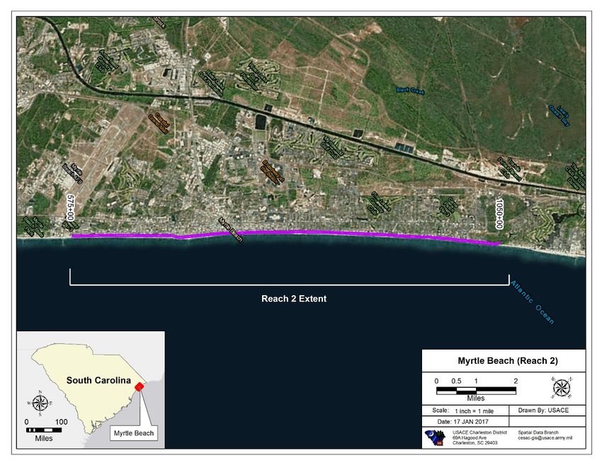
Myrtle Beach Storm Damage Reduction Project – City of Myrtle Beach (Reach 2)
DRAFT Environmental Assessment                                                                                          January 2018

Contents
1.0 Purpose and Need ..................................................................................................................... 2
  1.1 Project Authorization ............................................................................................................ 2
  1.2 Renourishment Trigger.......................................................................................................... 3
  1.3 Environmental Compliance ................................................................................................... 4
  1.4 Incorporation by Reference .................................................................................................. 5
2.0 Description of the Proposed Action .......................................................................................... 6
3.0 Alternatives Analysis ............................................................................................................... 11
  3.1 No Action ............................................................................................................................. 11
4.0 Environmental Consequences ................................................................................................. 12
  4.1 Water Quality ...................................................................................................................... 12
  4.2 Endangered/Threatened Species ........................................................................................ 13
  4.3 Coastal Zone Consistency (CZC) .......................................................................................... 15
  4.4 Coastal Barrier Resources System (CBRS) ........................................................................... 15
  4.5 Essential Fish Habitat (EFH) ................................................................................................. 15
  4.6 Archeological and Cultural Resources ................................................................................. 17
  4.7 Beach Benthic Impacts ........................................................................................................ 18
  4.8 Borrow Area Compatibility Analysis .................................................................................... 18
  4.9 Borrow Area Benthic Impacts ............................................................................................. 19
  4.10 Hazardous, Toxic and Radioactive Waste (HTRW) .............................................................. 20
  4.11 Air, Noise, and Aesthetics ................................................................................................... 20
  4.12 Irreversible and Irretrievable Commitments ...................................................................... 20
  4.13 Cumulative Impacts ............................................................................................................. 20
  4.14 Environmental Justice, Protection of Children.................................................................... 21
5.0 Conclusions.............................................................................................................................. 21
6.0 References ............................................................................................................................... 21
Myrtle Beach Storm Damage Reduction Project – City of Myrtle Beach (Reach 2)
DRAFT Environmental Assessment                                                        January 2018

Appendices
Appendix 1. Previous Supporting Documentation – 2007 Environmental Assessment and Appendices
Appendix 2. Water Quality Certification – SCDHEC Waiver Memo
Appendix 3. Previous Threatened and Endangered Species Coordination (2016/2017)
Appendix 4. Previous Coastal Zone Consistency Coordination (North Myrtle and Garden City/Surfside)
Appendix 5. Placeholder for Resource Agency and Public Comments
Myrtle Beach Storm Damage Reduction Project – City of Myrtle Beach (Reach 2)
DRAFT Environmental Assessment January 2018
1.0 Purpose and Need
1.1 Project Authorization
The Myrtle Beach Shore Protection Project (project) was authorized for construction by Section 101
of the Water Resources Development Act of 1990, Public Law 101-640, dated November 28, 1990
(WRDA 90). "(20) MYRTLE BEACH, SOUTH CAROLINA. The project for storm damage reduction,
Myrtle Beach, South Carolina: Report of the Chief of Engineers, dated March 2, 1989, at a total cost
of $59,730,000, with an estimated first Federal cost of $38,820,000 and an estimated first non-
Federal cost of $20,910,000, and an average annual cost of $1,215,000 for periodic nourishment over
the 50-year life of the project, with an estimated annual Federal cost of $790,000 and an estimated
annual non-Federal cost of $425,000." Section 934 of the Water Resources Development Act of 1986
(WRDA86), Public Law 99-662, authorized the Government to extend the Federal participation in
periodic beach nourishment until 2046. The Final Environmental Impact Statement (EIS) for the
project was completed in January 1993 with the Record of Decision (ROD) signed on November 1,
1993.
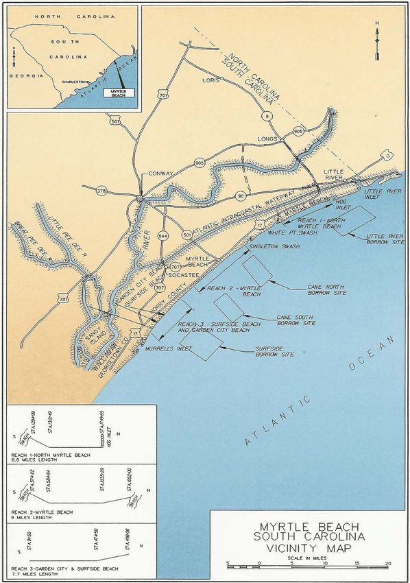
The authorized project required the U.S. Army Corps of Engineers (USACE) to construct protective
beach across three reaches – North Myrtle Beach (Reach 1), City of Myrtle Beach (Reach 2), and
Garden City/Surfside Beach (Reach 3). The total project reach was 25.3 miles (Figure 1). Periodic
nourishment is required every 10 years at Reach 1, and every 8 years with one 10-year effort at
Reaches 2 and 3. In addition, each reach has different sponsors. The Reach 1 Sponsor is North Myrtle
Beach, the Reach 2 Sponsor is the City of Myrtle Beach, and the Reach 3 Sponsor is Horry County.
The renourishment of the City of Myrtle Beach (Reach 2) for which this Draft Environmental
Assessment (EA) has been prepared is partially funded through Flood Control and Coastal
Emergencies (FCCE) funds under P.L. 114-254, Further Continuing and Security Assistance
Appropriations Act of 2017. These funds are specifically allowed for the restoration of Federal
Coastal Storm Damage Reduction projects damaged or destroyed by floods and coastal storms. The
proposed action is also being supported by USACE cost-shared construction general funding, since
Reach 2 was nearing time for periodic renourishment. The renourishment of Reach 2 is needed now
to repair damages from Hurricane Irma and Hurricane Matthew, combined with a periodic
renourishment, to provide the full authorized level of protection (see Section 1.2 below).
The purpose of this Draft EA is to determine whether the proposed action involves either a
substantial change to the project, or significant new circumstances or information relevant to
environmental concerns and bearing on the proposed action or its impacts, pursuant to Corps and
CEQ regulations (33 CFR 230.13(b) and 40 CFR 1502.9(c), respectively). If it is determined to involve
either a substantial change or significant new circumstances or information, a Supplemental
Environmental Impact Statement (EIS) will be prepared; if not, a Finding of No Significant Impact
(FONSI) will be prepared.
2Myrtle Beach Storm Damage Reduction Project – City of Myrtle Beach (Reach 2)
DRAFT Environmental Assessment January 2018
Figure 1. Map of Myrtle Beach Storm Damage Reduction Project
1.2 Renourishment Trigger
Hurricane Matthew and Hurricane Irma, both classified as Significant Storms, have adversely
impacted the Myrtle Beach Storm Damage Reduction Project, specifically the City of Myrtle Beach
3Myrtle Beach Storm Damage Reduction Project – City of Myrtle Beach (Reach 2)
DRAFT Environmental Assessment January 2018
(Reach 2). In late September 2016, Hurricane Matthew developed in the Caribbean, intensifying to
hurricane Category 5 status on October 1, 2016, when it began tracking towards the north. It
weakened to Category 2 status on October 8, 2016 while located offshore of the Florida/Georgia
border. It paralleled the Georgia and South Carolina coast, making landfall as a Category 1 storm near
McClellanville, SC. Hurricane Matthew reemerged offshore just south of Myrtle Beach, SC as a
Category 1 storm and tracked northeast, paralleling the North Carolina coast while transitioning to
extra-tropical status. The dunes and previously constructed berm along the City of Myrtle Beach
(Reach 2) experienced noticeable erosion. The beach profile was uneven but sloped, with occasional
observed berms and similar breaks in grade. Dunes were scarped in a few areas. Dunes were washed
out from overland stormwater pouring out onto the beach, and numerous swashes were significantly
eroded and sinuous gullies had formed.
Rehabilitation from Hurricane Matthew impacts was approved under PL 84-99 in April 2017. Prior to
initiation of the approved post-Hurricane Matthew rehabilitation, the Myrtle Beach Storm Damage
Reduction Project was impacted again, this time by Hurricane Irma during mid-September 2017.
Hurricane Irma made landfall along the Southwest Florida coast as a major, Category 3 hurricane on
September 10, 2017, and traveled northward impacting shorelines along the south Atlantic coast
from Florida through the Carolinas.
Hurricane Irma resulted in loss of dune and berm sand along the entire Myrtle Beach Storm Damage
Reduction Project. Hurricane Irma caused 219,760 cy of damage to North Myrtle Beach (Reach 1);
385,735 cy of damage to City of Myrtle Beach (Reach 2) (in addition to damages from Hurricane
Matthew for a total loss of 732,927 cy); and 561,328 cy of damage to Garden City/Surfside Beach
(Reach 3). Absent rehabilitation, public and private infrastructure and critical habitat are vulnerable
to damage.
The amount of material required to provide the full authorized level of protection to the City of
Myrtle Beach (Reach 2) will be approximately 1,100,000 cy. The full authorized level of protection
includes the USACE cost-shared construction general periodic renourishment funding, in addition to
sand losses from the recent storms being supported with FCCE funding. USACE and the non-federal
sponsor are in agreement regarding the need for renourishment of Reach 2.
1.3 Environmental Compliance
The USACE has previously described the effected environment and evaluated environmental effects
for the Myrtle Beach Storm Damage Reduction Project in the Feasibility Report on Storm Damage
Reduction (USACE, 1987), Environmental Impact Statement (USACE, 1993a), General Design
Memorandum (USACE, 1993b), and Environmental Assessment (2007) (see Appendix 1). The 1993 EIS
and 2007 EA are incorporated in this document by reference (see Section 1.4). For emergency
rehabilitation from the impacts of Hurricane Matthew under PL 84-99, an EA and Finding of No
Significant Impact (FONSI) were prepared and finalized in 2016 (jointly with the Bureau of Ocean
Energy Management) for Garden City/Surfside (Reach 3) and an EA and FONSI were prepared in early
2017 for North Myrtle Beach (Reach 1) (USACE and BOEM, 2016; USACE 2017). The recent findings of
4Myrtle Beach Storm Damage Reduction Project – City of Myrtle Beach (Reach 2)
DRAFT Environmental Assessment January 2018
the EA and FONSI for each reach remain current and are considered advisory for this Draft EA. Minor
updates to reflect emergency rehabilitation to Reaches 1 and 3 post-Hurricane Irma are being
summarized in a Supplemental Impact Report for each EA.
Pursuant to the National Environmental Policy Act (NEPA) of 1969, this Draft EA updates the position
of the USACE, Charleston District regarding the environmental effects associated with use of the
Cane South borrow area and renourishment of City of Myrtle Beach (Reach 2) of the Myrtle Beach
Storm Damage Reduction Project from previous environmental documentation. It evaluates the
impacts of emergency rehabilitation from both Hurricanes Matthew and Irma under PL 84-99. The
purpose is to determine if the proposed action involves a substantial change to the project that is
relevant to environmental concerns, or whether there are significant new circumstances or
information relevant to environmental concerns and bearing on the proposed action or its impacts,
either of which would warrant preparation of a supplemental EIS (33 CFR 230.13(b) and 40 CFR
1502.9(c)). For this Draft EA, the USACE has integrated the process of NEPA compliance with other
environmental requirements, including the Coastal Zone Management Act (CZMA), Endangered
Species Act (ESA), Magnuson-Stevens Fishery Conservation and Management Act (MSFCMA), and
National Historic Preservation Act (NHPA).
1.4 Incorporation by Reference
This document is intended to communicate new environmental information and update the
coordination between a number of Federal and State regulatory agencies. All other findings from the
aforementioned documents are still valid, however are not reiterated in this Draft EA. Specific details
for the project are provided in the following reports and are hereby incorporated by reference in
accordance with NEPA:
US Army Corps of Engineers. 1993. Final Environmental Impact Statement for the Myrtle
Beach and Vicinity Shore Protection Project, Horry and Georgetown Counties, South
Carolina. USACE Charleston District. January 1993.
US Army Corps of Engineers. 2007. Final Environmental Assessment: Myrtle Beach Storm
Damage Reduction Project. North Myrtle Beach, Myrtle Beach, and Horry County, SC. July
2007.
U.S. Army Corps of Engineers and Bureau of Ocean Energy Management. 2016.
Environmental Assessment for Myrtle Beach Storm Damage Reduction Project, Reach 3
Garden City and Surfside Beach, South Carolina. August 2016.
U.S. Army Corps of Engineers. 2017. Environmental Assessment for Myrtle Beach Storm
Damage Reduction Project, Reach 1 – North Myrtle Beach, Horry County South Carolina.
March 2017.
5Myrtle Beach Storm Damage Reduction Project – City of Myrtle Beach (Reach 2)
DRAFT Environmental Assessment January 2018
2.0 Description of the Proposed Action
As described above, the Myrtle Beach Storm Damage Reduction project consists of three reaches
which were constructed simultaneously for initial construction and past periodic nourishments. The
initial construction of City of Myrtle Beach (Reach 2) was completed in December 1997. Initial
placement consisted of 47.1 cy per linear foot of beach for a total placement of 2,250,000 cy. Reach 2
underwent its next periodic renourishment in 2008 with a volume of 1,442,500 cy of material to
return the beach to the full authorized level of protection.
The authorized project at the City of Myrtle Beach (Reach 2) consists of a protective storm berm and
an advanced nourishment berm. The protective storm berm reduces damages which will occur
during severe storm events. The protective storm berm has a top elevation of 9.0 NAVD 88 and a
crest width of 20 feet. The fore slope of the protective berm is 1-vertical to 20-horizontal down to
natural ground. The advanced nourishment berm acts as a buffer for the protective storm berm
against long term erosional forces. The advanced nourishment berm sits adjacent the protective
storm berm. The advanced nourishment berm has a top elevation of 6.0 NAVD 88 and a varying crest
width based on the current condition of the berm. The fore slope of the advanced nourishment is 1-
vertical to 5-horizontal down to elevation 2.0 NAVD 88 then a fore slope of 1-vertical to 20-horizontal
down to the bottom. Figure 2 is a general representation of the project profile (may not be exact).
Figure 2. Representative Profile for Myrtle Beach Storm Damage Reduction Project
The proposed action for which this Draft EA is focused is for emergency rehabilitation to the City of
Myrtle Beach (Reach 2) of the Myrtle Beach Storm Damage Reduction Project from Hurricane
Matthew and Hurricane Irma to the authorized project template using material from the Cane South
borrow area. Damage within the Reach 2 area from the recent storms consisted of berm erosion
along the length of Reach 2, coupled with dune scarping. Inspections following the passing of
6Myrtle Beach Storm Damage Reduction Project – City of Myrtle Beach (Reach 2)
DRAFT Environmental Assessment January 2018
Hurricane Irma noted no significant damage to shorefront infrastructure within the Reach 2 project
area. The majority of the sand loss took place seaward of the protective berm in the advanced
nourishment area. In other words, most of the loss was in the construction template and not in the
design template. The sand loss was evenly distributed throughout the length of the Reach 2 project
with no one area experiencing significantly more loss volumetrically than others. Overall, these
damages have lessened the Reach 2 project’s ability to provide the designed coastal storm damage
reduction for future storm events.
The City of Myrtle Beach (Reach 2) project extends from Station 575+00 to Station 1050+00, which
ends south of Singleton Swash (Figure 3). The length of Reach 2 is approximately 47,500 linear feet,
or 9 miles of shoreline. The proposed action also includes placement of dune grass, dune fencing,
and dune walkovers.
Figure 3. Extent of Proposed Renourishment at the City of Myrtle Beach (Reach 2)
The project will be constructed with a hopper dredge, booster pump, and land-based heavy
equipment (i.e. bulldozers and front-end loaders). The South Carolina Department of Natural
Resources (SCDNR) and Coastal Carolina University (CCU) have monitored for impacts from the
Myrtle Beach project in the past, and previously recommended the continued use of a hopper
7Myrtle Beach Storm Damage Reduction Project – City of Myrtle Beach (Reach 2)
DRAFT Environmental Assessment January 2018
dredge of borrow areas associated with the Myrtle Beach project to minimize benthic impacts and
foster quicker benthic recovery.
The borrow area for Reach 2 was identified in the March 1993 General Design Memorandum for the
project as the Cane South borrow area. Portions of the borrow area were used for the initial
construction in 1997 and again for the 2008 periodic renourishment. The Cane South borrow area
covers approximately 3.0 square miles offshore from Myrtle Beach and ranges from -27 feet along
the shoreward boundary to -34 feet MLLW along the state 3-nautical mile jurisdiction. Roughly 2/3 of
the borrow area lies with in South Carolina territorial waters. There are three protected hardbottom
and buffer zone areas that lie inside this borrow area.
The USACE performed a geotechnical evaluation of the Cane South borrow area in 2017 to verify
material quality and characteristics, and determine the available volume of high-quality beach fill
material for renourishment of Reach 2. More information on this evaluation can be found in Section
4.8. The analysis consisted of re-evaluating 2006 vibracore data against 2017 bathymetric data, and
evaluating 40 vibracores collected in July 2017 (Figure 4). Upon completion of the geotechnical
evaluation, the USACE identified two viable dredging zones for the proposed action that meet the
suitability requirements for the beach and lie within state jurisdictional waters, designated as Zones
A and B shown in Figure 5. Zone C, which lies in Federal waters, is not being considered at this time
for the proposed action.
Due to the emergency nature of this renourishment and the associated funding constraints, the
anticipated project timeframe is May through November 2018. However, this schedule could change
due to contractual issues, inclement weather, equipment failure, or other unforeseen difficulties. The
dredge will operate 24 hours per day, 7 days per week during construction.
Sand fencing will be placed along the landward edge of the nourishment fill to promote dune growth.
Native vegetation will be planted to further expedite dune formation and stabilization, as well as
creating beach dune habitat. Fencing will be installed according to sea turtle friendly design
standards specified in the SC Department of Health and Environmental Control – Office of Ocean and
Coastal Resource Management (SCDHEC- OCRM) “How to Build a Dune” brochure (Figure 6). Similar
sand fencing was completed in the 1998 project and the 2007/2008 project. Work is expected to take
place only during daylight hours and a limited amount of equipment, such as small backhoes and
tractors, is expected to be used on the beach. Sand fencing will be installed per the USACE Charleston
District’s standard design with 5.5-foot spacing between panels. The planting matrix will consist of
the following plants: bitter panicum (Panicum amarum “Northpa”), sea oats (Uniola paniulata),
seashore elder (Iva imbricate), and saltmeadow cordgrass (Spartina patens). Sweet grass
(Muhlenbergia “filipes”) will be planted on the toe of the backside of the dune system. The plants will
be spaced two feet on center, and rows will be spaced at two to four feet depending on which plant
species is in the row. Fertilizer will be placed in the hole at the time of planting. This project will both
protect infrastructure and restore and preserve dry sand and dune habitat used by shorebirds and
endangered species, such as nesting sea turtles. Impacts of beach nourishment projects are relatively
well understood. When projects are designed properly and the appropriate mitigation measures are
incorporated, the impacts are limited to a minimal temporal and spatial extent.
8Myrtle Beach Storm Damage Reduction Project – City of Myrtle Beach (Reach 2) DRAFT
Environmental Assessment January 2018
Figure 4. Vibracore Locations in Cane South Borrow Area
9Myrtle Beach Storm Damage Reduction Project – City of Myrtle Beach (Reach 2) DRAFT
Environmental Assessment January 2018
Figure 5. Proposed Dredging Zones in Cane South Borrow Area
10Myrtle Beach Storm Damage Reduction Project – City of Myrtle Beach (Reach 2)
DRAFT Environmental Assessment January 2018
Figure 6. Sand Fencing Typical Design
3.0 Alternatives Analysis
As previously mentioned, an agency assessment was performed in accordance with NEPA in the early
1990’s and documented within an EIS (USACE, 1993a). That document fully evaluated the
alternatives for the Myrtle Beach Storm Damage Reduction Project. Since the project is authorized
for 50 years of Federal involvement to include periodic renourishment, the original alternatives
analysis is still considered valid. Accordingly, the alternatives were not reevaluated in the 2007
Environmental Assessment, nor are they reevaluated here, with the exception of a no action
alternative.
3.1 No Action
Due to the erosion that has occurred along Myrtle Beach, and because of the Federal Government’s
commitment to renourish the beach when necessary over the life of the project, the No Action
alternative was rejected.
11Myrtle Beach Storm Damage Reduction Project – City of Myrtle Beach (Reach 2)
DRAFT Environmental Assessment January 2018
4.0 Environmental Consequences
4.1 Water Quality
Temporary degradation of water quality will occur at both the dredging site (i.e., offshore impacts)
and the nourishment site (i.e., onshore impacts) due to re-suspension of silt material. Regarding
beach placement impacts, multiple studies have been conducted on past beach nourishment projects
to determine the extent and duration of elevated suspended solids levels down-current of a dredge’s
discharge pipe along the placement site. In general, elevated concentrations were limited to within
an area 1,300 to 1,650 feet of the discharge pipe in the swash zone. Given that the beach fill material
proposed for this project has a low amount of fine-grained sediment, it is expected that the turbidity
plume generated at the placement site would be comparable to those reported in similar projects:
concentrated within the swash zone, dissipating between 1,000 to 2,000 feet alongshore; and short
term, only lasting several hours.
Regarding offshore impacts from dredging operations, studies of past hopper dredge projects
indicate that the extent of the sediment plume is generally limited to between 1,650 to 4,000 feet
from the dredge and that elevated turbidity levels are generally short-lived (on the order of an hour
or less). The length and shape of the plume depend on the hydrodynamics of the water column and
the sediment grain size. Usually, this plume is mostly the result of overflow of the hopper bin and not
at the suction end of the dredge’s drag arm. Monitoring studies done on the impacts of offshore
dredging indicate that sediments suspended within the water column during offshore dredging are
generally localized and rapidly dissipate or settle out when dredging ceases (Naqvi and Pullen 1982,
Bowen and Marsh 1988, Van Dolah et al. 1992). Given that the dominant substrate at the borrow site
is sand, it is expected that any disturbed sediment would settle rapidly and cause less turbidity and
oxygen demand than finer-grained sediments. No appreciable effects on dissolved oxygen, pH, or
temperature are anticipated, because the dredged material has low levels of organics and moderate
biological oxygen demand. Additionally, dredging activities would occur within the open ocean where
the hydrodynamics of the water column are subject to mixing and exchange with oxygen-rich surface
waters. Any resultant water column turbidity would be short term (i.e., present for approximately an
hour) and would not be expected to extend more than several thousand feet from the dredging
operation. Accordingly, it is anticipated that the project would have only minor water quality impacts
at the offshore borrow areas.
The original nourishment project was granted a water quality certification by the South Carolina
Department of Health and Environmental Control (SCDHEC) on November 19, 1993. On March 30,
2007, SCDHEC issued another water quality certification with the following conditions:
1. All necessary measures must be taken to prevent oil, tar, trash, debris, and other
pollutants from entering the adjacent waters or wetlands during construction.
2. Only clean sand, free of all potential sources of pollution, must be used for beach
nourishment.
12Myrtle Beach Storm Damage Reduction Project – City of Myrtle Beach (Reach 2)
DRAFT Environmental Assessment January 2018
3. Sand used for the project must consist of appropriate grain sizes to be compatible for
beach nourishment.
4. Sand used must be at least 80% sand.
5. The permittee must adhere to any recommendations of the US Fish and Wildlife
Service (USFWS) and/or the SCDNR to protect any identified threatened and/or
endangered species and the habitats of such species in the area of the proposed
project.
SCDHEC has temporarily waived the requirement for water quality certification for beach
nourishment projects (see Appendix 2); therefore, a new/updated water quality certification is not
needed for this renourishment project. Regardless, the USACE is committed to ensuring that all
previous conditions will continue to be adhered to during project construction. Section 404 of the
Clean Water Act governs the discharge of dredged or fill material into waters of the U.S. Although the
USACE does not process and issue permits for its own activities, the USACE completed a 404(b)(1)
evaluation for this project in 1997, and the findings of this evaluation are still considered valid.
4.2 Endangered/Threatened Species
Coordination was previously conducted in compliance with the Endangered Species Act (ESA) with
the submission of a Biological Assessment (BA) to the USFWS in September 2006 to consider
potential impacts of the Myrtle Beach Storm Damage Reduction Project on threatened and
endangered species that may be present, and their critical habitat. The USFWS’ Biological Opinion
(BO) was received in January 2007 (see Appendix 1). In April 2016, the USACE again prepared a
Biological Assessment of threatened and endangered species, and an EA for emergency
renourishment of Garden City/Surfside Beach (Reach 3). The USACE later prepared an EA for North
Myrtle Beach (Reach 1) in March 2017, and the USFWS issued a BO to address both Reaches 1 and 3
for the Myrtle Beach Storm Damage Reduction Project in June 2017 (Appendix 3).
Informal consultation for City of Myrtle Beach (Reach 2) has been initiated with USFWS. The recent
BA and EA’s for Reaches 1 and 3 have already evaluated new species and habitat listings since the
2007 project. Consideration of potential endangered species and critical habitat impacts at Reach 2
are similar to those evaluated for Reaches 1 and 3, and will be presented in an amendment to the
2016 BA, which is currently being prepared by the USACE. It was also address updated actions for
Reaches 1 and 3. Appropriate revision of the 2017 BO will be obtained from USFWS.
The USACE will make a determination that the proposed action for Reach 2 will have no effect, or
may affect but not likely to adversely affect, federally listed species. These determinations are
summarized below, and are consistent with determinations made in previous NEPA documents and
ESA consultations for the project. With respect to nesting loggerhead sea turtles and their hatchlings,
the project area for the proposed action (City of Myrtle Beach, Reach 2) is not federally designated as
“critical habitat,” but loggerheads are still likely to be present, and the beach nourishment work
could impact them. Proven conservation measure will be incorporated into the project to minimize
13Myrtle Beach Storm Damage Reduction Project – City of Myrtle Beach (Reach 2)
DRAFT Environmental Assessment January 2018
impacts, so that adverse effects are not anticipated. These will be the same conservation measures
implemented for the actions conducted at Reaches 1 and 3 last year as outlined in the 2017 BO,
which resulted in no reports of adverse impacts to loggerhead sea turtles (or any other species).
Green sea turtles have also nested on Myrtle Beach in the past, but is a rare occurrence. The same
conservation measures for loggerheads will also protect other sea turtle species. Conservation
measures that apply for the threatened and endangered species listed below will be more fully
described in the forthcoming BA amendment.
Project-specific coordination with NOAA Fisheries with respect to sturgeon, the North Atlantic right
whale, and sea turtles is not needed due to the existence of a Regional Biological Opinion (RBO) for
the South Atlantic Region. However, the USACE has notified NOAA Fisheries of this emergency
renourishment and of its intent to adhere to the RBO.
The RBO addresses dredging operations and provides guidance and requirements on a state by state
basis. The USACE had previously determined that the use of a hopper dredge may adversely affect
sea turtles. NOAA Fisheries concurred with this determination in their 1995/1997 RBO and again in
July 2009, and determined that take resulting from hopper dredging activity will not jeopardize the
continued existence of any sea turtle species. The RBO and the terms and conditions outlined within
it can be viewed via the internet at:
http://sero.nmfs.noaa.gov/protected_resources/section_7/freq_biop/
Proposed determinations for species under jurisdiction of NOAA Fisheries:
• The proposed action will have no effect on the shortnose sturgeon.
• The proposed action may affect but is not likely to adversely affect the Atlantic sturgeon.
• The proposed project may affect but is not likely to adversely affect the North Atlantic right
whale, and is not likely to result in the destruction or adverse modification of right whale
critical habitat.
Proposed determinations for species under jurisdiction of USFWS:
• The proposed action may affect but is not likely to adversely affect the piping plover.
• The proposed action may affect but is not likely to adversely affect the rufa red knot.
• The proposed action may affect but is not likely to adversely affect seabeach amaranth.
• The proposed action will have no effect on critical habitat for the wintering piping plover.
• The proposed project will have no effect on critical habitat for the loggerhead sea turtle.
Proposed determinations for species under jurisdiction of USFWS and NOAA Fisheries:
• The proposed action may affect but is not likely to adversely affect the West Indian manatee.
• The proposed action may affect but is not likely to adversely affect Kemp’s ridley,
leatherback, hawksbill, green, and loggerhead sea turtles.
14Myrtle Beach Storm Damage Reduction Project – City of Myrtle Beach (Reach 2)
DRAFT Environmental Assessment January 2018
4.3 Coastal Zone Consistency (CZC)
The Coastal Zone Management Act (CZMA), passed in 1972, provides for the management of the
nation's coastal resources by balancing economic development with environmental conservation.
The goal of the CZMA is to "preserve, protect, develop, and where possible, to restore or enhance
the resources of the nation's coastal zone." The CZMA applies to many different federal actions
including federal agency activities, federal license or permit activities, outer continental shelf plans,
and federally assisted state projects. The CZMA promotes cooperation and coordination between
states and the federal government in order to promote federal consistency and protect our nation's
coastal resources. Federal agencies provide states with a consistency determination for federal
agency activities.
The initial Myrtle Beach Storm Damage Reduction Project satisfied the restrictions and guidelines of
the South Carolina Coastal Zone Management Program pursuant to the CZMA (Code of Federal
Regulations, Title 15, Part 930). The 2007 project also received a Coastal Zone Consistency
Determination on April 2006 from SCDHEC-OCRM (see Appendix 1). To update the last coordination
with SCDHEC-OCRM, a concurrence for the Garden City/Surfside (Reach 3) project was submitted to
SCDHEC- OCRM in 2016 and for the North Myrtle Beach (Reach 1) project in March 2017. In June
2017, SCDHEC-OCRM conditionally concurred with the determinations that the project at both
reaches was consistent to the maximum extent practicable, with conditions (Appendix 4). The
concurrence was based on consistency of the project with these applicable enforceable policies: (1)
Wildlife and Fisheries Management, (2) Dredging, (3) Erosion Control, (4) Activities in Areas of Special
Resource Significance, (5) Beach and Shore Access, and 6) Geographic Areas of Particular Concern.
The USACE is currently reassessing these policies for the proposed action at Reach 2 and the Cane
South borrow area, and if necessary, for updated actions at Reaches 1 and 3. The USACE is in contact
with SCDHEC-OCRM with respect to making an updated determination that the project action is
consistent with the enforceable policies of the state, and will seek concurrence on this
determination. The determination and concurrence for Reach 2 is expected to be similar to those for
Reaches 1 and 3.
4.4 Coastal Barrier Resources System (CBRS)
There are no project areas within the City of Myrtle Beach (Reach 2) that coincide with the
designated units of the Coastal Barrier Resources System.
4.5 Essential Fish Habitat (EFH)
Beaches and nearshore areas along the Grand Strand provide habitat for numerous species that
serve as prey for finfish and crustaceans that have economic and recreational importance, such as
southern flounder (Paralichthys lethostigma), Florida pompano (Trachinotus carolinus), summer
15Myrtle Beach Storm Damage Reduction Project – City of Myrtle Beach (Reach 2)
DRAFT Environmental Assessment January 2018
flounder (Paralichthys dentatus), red drum (Sciaenops ocellatus), spot (Leiostomus xanthurus),
bluefish (Pomatomus saltatrix), white shrimp (Litopenaeus setiferus), and blue crab (Callinectes
sapidus). Sea turtles also are common in the nearshore coastal waters of the project area, and the
beach is used by sea turtles, including the threatened loggerhead sea turtle (Caretta caretta), for
nesting.
The South Atlantic Fishery Management Council (SAFMC) has identified the surf zone of ocean
beaches as EFH for sub adult and adult red drum. As juvenile red drum develop into sub adults and
adults, they utilize and become concentrated in progressively higher salinity estuarine and
beachfront surf zones where their prey is most abundant. Areas of hard bottom habitat also are
present within the Myrtle Beach Storm Damage Reduction Project area, and the SAFMC has
designated hard bottom habitat as EFH for snapper-grouper species and coastal migratory pelagic
species.
An EFH Assessment was completed for the 2007 project as required by the Magnuson-Stevens
Fishery Conservation and Management Act of 1976, as amended through 1996 (Magnuson-Stevens
Act). The objectives of this EFH Assessment were to describe how the project potentially influences
the quality of habitat designated by NMFS and the South Atlantic Fisheries Management Council
(SAFMC). The EFH Assessment describes fish, coral, and benthic species common to the sandy
borrow and nearshore areas and hardbottom habitats (for all three reaches) and discusses the
potential impacts of the proposed action on those species. The 2007 EFH Assessment and the
Conservation Recommendations from NMFS are included in Appendix 1. In 2007, NMFS concluded
that adverse impacts were likely to result from the nourishment project and provided four
conservation recommendations. The USACE responded to these recommendations with a number of
measures to avoid, mitigate or offset adverse impacts of the project, including no-dredging buffers
around hard bottom areas; methods for ensuring beach-compatible sand is placed; and post-
construction monitoring.
A four-year study of the Myrtle Beach renourishment conducted by the CCU Center for Marine and
Wetland Studies in association with the SCDNR and USACE concluded that offshore habitats had not
been significantly impacted by dredging conducted for the initial beach fill (McCoy et al., 2010). The
study found that while some areas of hard bottom experienced deposition and burial, other hard
bottom habitats were uncovered due to erosion of their surface sediments. Consequently, the
dredging and placement activities were found to have only marginally greater impacts on hard
bottom habitat than the system’s own natural variability.
Other monitoring associated with the 2008 renourishment project was conducted one year pre-
nourishment and one year post-nourishment to assess impacts of migrating beach fill on habitat-
structuring invertebrate communities in the hard bottom areas (Burgess et al., 2011). Twenty-one
sites were established in two parallel strata extending from approximately one kilometer (km) north
of the Myrtle Beach State Park to approximately five km south of the park using a Before-After-
Impact-Reference design. Each station was equipped with a biological monitoring array containing
eight settlement tiles and four hard bottom monitoring transects. At each site, four 5.0-meter
transects were video surveyed, and sessile fauna in the video were identified to the lowest practical
16Myrtle Beach Storm Damage Reduction Project – City of Myrtle Beach (Reach 2)
DRAFT Environmental Assessment January 2018
taxonomic or structural/functional group. Invertebrate communities on recruitment tiles were
dominated by early-successional, fast-growing taxa such as tubiculous polychaetes, bryozoans,
hydroids, amphipods, and bivalves. Both recruitment and video data were analyzed to determine
whether invertebrate recruitment at impact and reference areas responded differently between the
before and after time periods. The amount of total surface cover on recruitment tiles was greater
after nourishment than before nourishment and was generally greater overall at stations adjacent to
nourished sections of the beach. Overall, there was little statistically significant evidence to suggest
that invertebrate recruitment or community composition were impacted within one year of the
completion of nourishment.
Monitoring associated with the recent emergency renourishment of Garden City/Surfside (Reach 3) is
currently underway. It is intended to further the understanding of any potential impacts of dredging
offshore borrow areas on higher level trophic interactions based on the quality and function of the
bottom habitat. The study uses an acoustic telemetry array to assess natural movements and habitat
preferences of federally-managed fish species associated with the borrow area. Since the dredging
for that action occurred during the summer season, it will also contribute to the understanding of
impacts of renourishment projects during periods of high biological productivity. Results are not
available yet.
For the proposed emergency rehabilitation of Reach 2, the same previously-considered impacts to
EFH assessed in the 2007 EA for the overall project are expected, and the same conservation
measures will be implemented as appropriate. Long-term impacts to benthos at both borrow and fill
sites of summertime beach renourishment projcts are still not well understood. Similar to the recent
Reach 3 emergency renourishment, the proposed action will occur over the summer to fall seasons.
The USACE is already coordinating with NMFS to better understand the EFH impacts of beach
renourishment activities during high biological productivity periods, and will continue this effort.
4.6 Archeological and Cultural Resources
Federal undertakings must comply with the Archaeological and Historical Preservation Act of 1974
(16 USC 469-469c), the Abandoned Shipwreck Act of 1987 (PL 100-298; 43 USC 2101- 2106), The
National Historic Preservation Act of 1966, as amended (54 USC 2106) and the Advisory Council on
Historic Preservation’s implementing regulations 36 CFR Part 800 (protection of Historic Properties).
Section 106 of the National Historic Preservation Act (NHPA) requires Federal agencies to provide the
Advisory Council on Historic Preservation with a reasonable opportunity to comment on a Federal
undertaking. The placement of sand on beaches and the use of sand from offshore borrow areas are
typically subjected to cultural resources investigations in order to locate potentially significant
resources, including historic properties for purposes of NHPA Section 106 review. Previous
investigations for all 3 reaches of the Myrtle Beach Storm Damage Reduction Project revealed that
there are no historical or archaeological resources within the beach nourishment zone which would
be affected by the placement and movement of sand.
17Myrtle Beach Storm Damage Reduction Project – City of Myrtle Beach (Reach 2)
DRAFT Environmental Assessment January 2018
In 2007, an archaeological remote sensing survey was completed for the Myrtle Beach Storm
Damage Reduction Project offshore borrow areas. Targets identified during the survey of the Cane
South borrow area were shown to have “little potential to be associated with significant cultural
resources” and no additional underwater investigation or mitigation was recommended. Analysis of
sub-bottom records resulted in “no indication of stratification or protected deposition of surficial
(Late Pleistocene or Holocene) sediments that would contain or support any remnant evidence of
human occupation or usage.” As a result, no additional underwater archaeological investigations of
sub-bottom were recommended. In a letter dated April 19, 2007, the State Historic Preservation
Officer (SHPO) concurred and provided a NHPA Section 106 concurrence (see Appendix 1). This is still
considered valid since the same borrow area will be used for the proposed action.
Side scan sonar and magnetometer surveys will be performed on the pipeline corridor leading from
the borrow area to the beach prior to placement. The results of the surveys will be shared with the
SHPO and South Carolina Institute of Archeology and Anthropology electronically in a timely manner,
and any unexpected discoveries will be reported. If any unexpected discoveries are made, additional
surveys will be conducted to identify potential areas to relocate the pipeline.
4.7 Beach Benthic Impacts
Assessment of known impacts to benthos at the placement areas for the Myrtle Beach Storm
Damage Reduction Project are described at length in the 2016 EA for Garden City/Surfside Beach
(Reach 3) and the 2017 EA for North Myrtle Beach (Reach 1). In general, studies have shown that the
recovery time for benthos in beach placement areas ranged from approximately two months to six
months when there is a good match between the fill material and the natural beach sediment. For
the proposed action, results of the borrow area compatibility analysis are presented below in Section
4.8.
Results of a monitoring program performed along with the 2007 renourishment of the Myrtle Beach
Storm Damage Reduction Project (Bergquist et al., 2011a) confirmed that impacts of beach
nourishment on invertebrate species is short term and relatively minor, especially for ghost crab
populations. Most of the studies from South Carolina beach renourishment studies were conducted
for wintertime renourishments. Little information is available on the impacts of benthos at
placement areas during the summertime in South Carolina, as mentioned in Section 4.5 above.
4.8 Borrow Area Compatibility Analysis
The USACE performed a geotechnical evaluation of the Cane South borrow area in order to verify
material quality and characteristics and to determine the available volume of high-quality beach fill
material for the proposed action. The analysis consisted of re-evaluating the existing 2006 vibracore
data against 2017 bathymetric data, and evaluating 40 vibracores collected in July 2017. These new
vibracores were collected by Athena Technologies’ custom designed and fabricated vibracoring
machine, which utilizes a 3-inch diameter galvanized steel sampling barrel. The target penetration
18Myrtle Beach Storm Damage Reduction Project – City of Myrtle Beach (Reach 2)
DRAFT Environmental Assessment January 2018
depth for the investigation was 10 feet or when refusal was encountered. A penetrometer was used
to determine depth advancement into the seafloor and the penetration rates were recorded. The
2017 core locations were surveyed utilizing Real Time Kinematic (RTK) Global Positioning System
(GPS) to accuracies within 0.2 feet vertically and horizontally. All cores were split open,
photographed, logged and visually classified in accordance with the Unified Soil Classification System.
Draft drilling logs and photographic logs were provided to USACE for sample interval selection.
Visually classified sandy sediments were selected for gradation testing. Strata that was classified as
silt, clay or sandy material lying below a thick horizon of fine-grained material was not selected for
testing. A total of 160 samples were selected for gradation testing to verify field classification
(American Society for Testing and Materials [ASTM] D2487), determine particle size distribution
(ASTM 6913), and percent shell, limestone and fines passing the #200 sieve. The laboratory and field
data were then reconsolidated by the USACE and evaluated in-house using gINT and ArcGIS software
to determine the vertical and horizontal spatial relationships of the subsurface strata.
Three areas (designated Zones A through C on Figure 5) were found to have the thickest deposits of
suitable beach fill material. Within these zones, significant quantities of suitable beach fill lie above
the designated cutoff elevations; however, Zone C is not being considered for the proposed action at
this time. The volume estimates and cut-off elevations in each zone are provided below:
• Zone A, if dredged to -36 feet MLLW, is expected to yield 1,850,000 cubic yards of suitable
beach fill sand. If the dredge depth is increased to -38 feet MLLW, the area footprint decreases, but
the expected yield increases to 2,100,000 cubic yards.
• Zone B, if dredged to -34 feet MLLW, is expected to yield 700,000 cubic yards of suitable
beach fill sand.
• Zone C, if dredged to -36 feet MLLW, is expected to yield 550,000 cubic yards of suitable
beach fill sand, however, it will not dredged for the proposed project.
4.9 Borrow Area Benthic Impacts
The known impacts of dredging sediments from borrow areas, both in South Carolina state waters
and within the Outer Continental Shelf, are also covered extensively in the 2016 EA for Garden
City/Surfside Beach (Reach 3) and the 2017 EA for North Myrtle Beach (Reach 1). In general, studies
have shown that while recovery rates are variable, the abundance and diversity of benthic infauna
within the borrow areas frequently return to pre-nourishment levels relatively quickly, often within
post-dredging recovery periods of 1 to 2 years. Most studies indicate that dredging only has
temporary effects on the infaunal community, and in some studies, differences in infaunal
communities were attributed to seasonal variability or to hurricanes rather than to dredging. As
already covered in Section 4.5 above, in a study performed for the 2008 renourishment project, two
of the borrow areas were evaluated for surficial sediment composition and benthic community
recovery (Bergquist et al., 2011b). The changes in sediment composition at both areas were similar
to those changes that occurred during the 1996 initial nourishment project. Section 4.5 above also
19Myrtle Beach Storm Damage Reduction Project – City of Myrtle Beach (Reach 2)
DRAFT Environmental Assessment January 2018
explains that hardbottom areas in and adjacent to the borrow areas, that support complex
communities, have been identified by previous surveys and will be avoided during the proposed
dredging.
Understanding the full range of impacts and recovery of benthos at borrow sites is still an important
aspect in the long term management of offshore sand resources, and monitoring is continuing.
Section 4.5 above describes a current study associated with the Myrtle Beach Storm Damage
Reduction Project to assess the impacts of dredging on higher trophic level interactions, but data are
not available yet.
4.10 Hazardous, Toxic and Radioactive Waste (HTRW)
There are currently no known HTRW producers adjacent to the project area or any entity that
discharges toxic effluent nearby. Since the area has been constructed multiple times, there is
minimal risk of encountering HTRW on the beach or in the borrow area.
4.11 Air, Noise, and Aesthetics
These issues were addressed in the 1993 EIS and reanalyzed in the 2016 EA for Garden City/Surfside
Beach (Reach 3) and the 2017 EA for North Myrtle Beach (Reach 1) renourishments (USACE 1993a,
USACE 2017, USACE and BOEM 2016). The findings from the 1993 EIS have been revalidated,
including by the analysis in the recent EAs which would also apply to the proposed action since Reach
2 is bracketed by Reaches 1 and 3 as part of the same Myrtle Beach Storm Damage Reduction
Project.
4.12 Irreversible and Irretrievable Commitments
An irreversible commitment of resources is one in which the ability to use and/or enjoy the resource
is lost forever. Other than the use of fuel, equipment and supplies, there will be no irreversible
commitment of resources.
4.13 Cumulative Impacts
Cumulative impacts were fully evaluated in the 2007 EA for the Myrtle Beach Storm Damage
Reduction Project, are still considered valid, and are incorporated by reference herein (see Appendix
1). The following paragraph summarizes the conclusion of that impact assessment:
“A relatively small segment of the South Carolina coastline and nearshore, including the
borrow areas, are likely to be affected by the proposed action. The impact area would not
increase significantly since portions of the areas proposed for dredging and fill have
previously been dredged or had sand deposition. On a statewide scale, the existing and
20Myrtle Beach Storm Damage Reduction Project – City of Myrtle Beach (Reach 2)
DRAFT Environmental Assessment January 2018
approved placement sites are well distributed in northern, central and southern parts of the
state. It is unlikely that cumulative impacts from space crowded perturbation are occurring
or will occur due to the construction of this project. The analysis suggests that the potential
impact area from the proposed and existing actions is small relative to the area of available
similar habitat on a vicinity, statewide, and basin basis. Also, for some species, such as sea
turtles and seabeach amaranth, beach projects may provide additional habitat or improve
existing habitat by replacing beach material lost to erosion. Invertebrates are expected to
recover in and adjacent to the borrow areas.”
4.14 Environmental Justice, Protection of Children
No disproportionately high and adverse environmental effects are anticipated for low income or
minority communities as a result of the project proposed herein. Similarly, the proposed project does
not present any material environmental health or safety risk to children.
5.0 Conclusions
The USACE identified and reviewed new information to determine if any resources should be re-
evaluated or if the new information would alter previously-updated impact determinations. While
this Draft EA further supports and elaborates on the analyses and information presented in existing
NEPA documents for the Myrtle Beach Storm Damage Reduction Project, it does not materially
change the substance or conclusions of prior NEPA analyses, as updated. These analyses are still
deemed valid and are incorporated by reference (see Section 1.4). No substantial change to the
Myrtle Beach Storm Damage Reduction Project has occurred, nor are there significant new
circumstances or information relevant to environmental concerns and bearing on the proposed
action or its impacts, such that a supplemental EIS is warranted pursuant to 33 CFR 230.13(b) and 40
CFR 1502.9(c). Since the proposed action does not merit a supplemental EIS, the USACE will issue a
FONSI for the proposed emergency rehabilitation of Reach 2 (City of Myrtle Beach).
6.0 References
Bergquist, Derk C., Stacie E. Crowe, and Martin V. Levisen. 2011a. The 2007-2009 Grand Strand
Renourishment Project: Responses of sediment characteristics and a macroinvertebrate
indicator species, Ocypode quadrata. Submitted to: US Army Corps of Engineers, Charleston
District, Prepared by: Marine Resources Research Institute, Marine Resources Division, SC
Department of Natural Resources.
Bergquist, Derk C., Stacie E. Crowe, and Martin V. Levisen. 2011b. The 2007-2009 Grand Strand
Renourishment Project: Physical and biological responses of the Little River and Cane South
Borrow Areas to dredging. Submitted to: US Army Corps of Engineers, Charleston District,
21Myrtle Beach Storm Damage Reduction Project – City of Myrtle Beach (Reach 2)
DRAFT Environmental Assessment January 2018
Prepared by: Marine Resources Research Institute, Marine Resources Division, SC
Department of Natural Resources.
Burgess, Dany E., George H.M. Riekerk, and Derk C. Bergquist. 2011. The 2007-2009 Grand Strand
Renourishment Project: Impact of sand migration on invertebrate communities associated
with nearshore hardbottom habitats. Submitted to: US Army Corps of Engineers, Charleston
District, Prepared by: Marine Resources Research Institute, Marine Resources Division, SC
Department of Natural Resources.
Bowen, P.R., and G.A. Marsh. 1988. Benthic Faunal Colonization of an Offshore Borrow Pit in
Southeastern Florida. Misc. Rept. D-88-5. U.S. Army Corps of Engineers, Dredging Operations
Technical Support program, Vicksburg, MS.
McCoy, Clay, Jenna Hill, Paul Gayes, Jeff Marshall, Shinobu Okano, Brian Johnson, Matthew Howe,
Shannon Klotsko. 2010. 2007 – 2010 Grand Strand Beach Nourishment Study: Final Report.
Submitted to: US Army Corps of Engineers, Charleston District, Submitted by: Burroughs and
Chapin Center for Marine and Wetland Studies, Coastal Carolina University. September 2010.
Naqvi, S.M., and C.H. Pullen. 1982. Effects of beach nourishment and borrowing on marine
organisms. U.S. Army Corps of Engineers, Coastal Engineering Research Center, Misc. Rept.
82-14. Vicksburg, MS.
U.S. Army Corps of Engineers. 1987. Myrtle Beach and Vicinity Shoreline Protection Project, Horry
and Georgetown Counties, South Carolina Final Feasibility Report on Storm Damage
Reduction.
U.S. Army Corps of Engineers. 1993a. Myrtle Beach and Vicinity Shoreline Protection Project, Horry
and Georgetown Counties, South Carolina Final Environmental Impact Statement.
U.S. Army Corps of Engineers. 1993b. General Design Memorandum: Myrtle Beach, South Carolina
Shore Project Project.
U.S. Army Corps of Engineers. 2017. Environmental Assessment for Myrtle Beach Storm Damage
Reduction Project, Reach 1 – North Myrtle Beach, Horry County South Carolina. March 2017.
http://www.sac.usace.army.mil/Portals/43/docs/civilworks/nepadocuments/mbreachoneres
toration/Draft%20EA.pdf?ver=2017-03-17-152451-583
U.S. Army Corps of Engineers and Bureau of Ocean Energy Management. 2016. Environmental
Assessment for Myrtle Beach Storm Damage Reduction Project, Reach 3 Garden City and
Surfside Beach, South Carolina. August 2016.
http://www.sac.usace.army.mil/Portals/43/docs/civilworks/nepadocuments/gardencitysurfsi
de/FINAL_EA_MyrtleBeach_2016_Renourishment-20160801-
all%20appendices.pdf?ver=2016-08-05-133937-703
Van Dolah, R.F., P.H. Wendt, R.M. Martore, M.V. Levisen, and W.A. Roumillat. 1992. A Physical and
Biological Monitoring Study of the Hilton Head Beach Nourishment Project. Final Report,
prepared for the Town of Hilton Head Island and the South Carolina Coastal Council.
22You can also read