Severe Storms - Cayuga County Hazard ...
←
→
Page content transcription
If your browser does not render page correctly, please read the page content below
Section 5.4.3: Risk Assessment – Severe Storms

        Severe Storms
The following section provides the hazard profile and vulnerability assessment for the severe storm hazard in
Cayuga County.

5.4.3.1      Profile
This section presents information regarding the description, extent, location, previous occurrences and losses,
climate change projections and probability of future occurrences for the severe storm hazard.

Hazard Description
For this HMP the severe storm hazard includes: thunderstorms, lightning, hail, tornadoes, high winds, and
hurricanes/tropical storms, which are defined below.

Thunderstorms
A thunderstorm is a local storm produced by a cumulonimbus cloud and accompanied by lightning and thunder
(NWS 2009). A thunderstorm forms from a combination of moisture, rapidly rising warm air, and a force capable
                                                   of lifting air, such as a warm and cold front, a sea breeze, or a
        Thunderstorms can lead to flooding,        mountain. Thunderstorms form from the equator to as far north
   landslides, strong winds, and lightning. Roads  as Alaska. Although thunderstorms generally affect a small area
      could become impassable from flooding,       when they occur, they have the potential to become dangerous
     downed trees or power lines, or a landslide.
                                                   due to their ability in generating tornadoes, hailstorms, strong
  Downed utility poles can lead to utility losses,
  such as electricity, phone, and water (from loss winds, flash flooding, and lightning. The NWS considers a
       of pumping and filtering capabilities).     thunderstorm severe only if it produces damaging wind gusts of
                                                   58 mph or higher or large hail one-inch (quarter size) in diameter
                                                   or larger or tornadoes (NWS 2009).

Lightning
Lighting is a bright flash of electrical energy produced by         Lightning can damage homes and injure people. In
a thunderstorm. The resulting clap of thunder is the result          the United States, an average of 300 people are
of a shock wave created by the rapid heating and cooling            injured and 80 people are killed by lightning each
of the air in the lightning channel. All thunderstorms             year. Typical thunderstorms are 15 miles in diameter
                                                                     and last an average of 30 minutes. An estimated
produce lightning and are very dangerous. Lightning ranks
                                                                   100,000 thunderstorms occur each year in the United
as one of the top weather killers in the United States,               States, with approximately 10 percent of them
killing approximately 50 people and injuring hundreds                 classified as severe. During the warm season,
each year. Lightning can occur anywhere there is a                thunderstorms are responsible for most of the rainfall.
thunderstorm. Lightning can be cloud to air, cloud to
cloud, and cloud to ground.

Hailstorms
Hail forms inside a thunderstorm where there are strong updrafts of warm air and downdrafts of cold water. If a
water droplet is picked up by the updrafts, it can be carried well above the freezing level. Water droplets freeze
when temperatures reach 32 °F or colder. As the frozen droplet begins to fall, it might thaw as it moves into
warmer air toward the bottom of the thunderstorm, or the droplet might be picked up again by another updraft
and carried back into the cold air to re-freeze. With each trip above and below the freezing level, the frozen
droplet adds another layer of ice. The frozen droplet, with many layers of ice, falls to the ground as hail.

        Hazard Mitigation Plan Update – Cayuga County, New York                                                    5.4.3-1
        MONTH 2021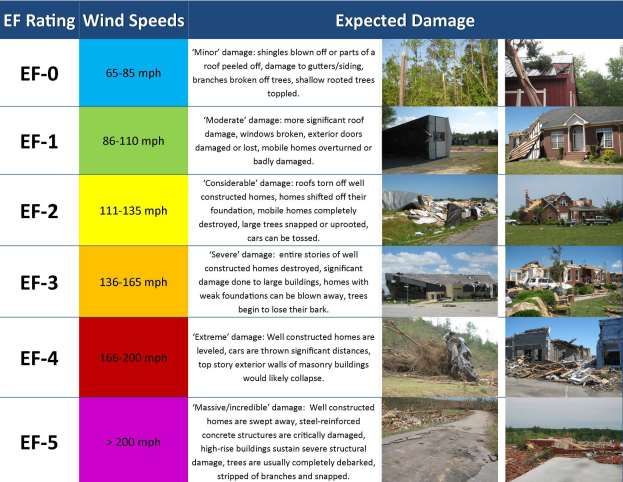
Section 5.4.3: Risk Assessment – Severe Storms

High Winds
Wind begins with differences in air pressures. It is rough horizontal movement of air caused by uneven heating
of the earth’s surface. Wind occurs at all scales, from local breezes lasting a few minutes to global winds resulting
from solar heating of the earth (Rosenstiel School of Marine & Atmospheric Science 2005). High winds are
often associated by other severe weather events such as thunderstorms, tornadoes, hurricanes, and tropical
storms.

Tornadoes
A tornado appears as a rotating, funnel-shaped cloud that extends from a thunderstorm to the ground with
whirling winds that can reach 250 miles per hour (mph). Damage paths can be greater than 1 mile wide and 50
miles long. Tornadoes typically develop from either a severe thunderstorm or hurricane as cool air rapidly
overrides a layer of warm air. Tornadoes typically move at speeds between 30 and 125 mph and can generate
combined wind speeds (forward motion and speed of the whirling winds) exceeding 300 mph. The lifespan of a
tornado rarely is longer than 30 minutes (FEMA 1997). Tornadoes can occur at any time of the year, with peak
seasons at different times for different states (NSSL 2013).

Hurricanes/Tropical Storms
A tropical storm system is characterized by a low-pressure center and numerous thunderstorms that produce
strong winds of 39 to 73 mph and heavy rain. A hurricane is a tropical storm that attains hurricane status when
its wind speed reaches 74 mph or higher. Tropical systems can develop in the Atlantic between the Lesser
Antilles and the African coast or in the warm tropical waters of the Caribbean Sea and Gulf of Mexico. These
storms can move up the Atlantic coast of the United States, impacting the eastern seaboard, or move into the
United States through the states along the Gulf Coast, bringing wind and rain as far north as New England before
moving eastward offshore.

While hurricanes are often experienced in lower Hudson Valley, New York City, and even parts of the Southern
Tier region, the northern counties like Cayuga County are less likely to experience loss from flood (NYS DHSES
2014). Hurricanes and tropical storms can impact New York State from June to November, the official eastern
U.S. hurricane season; however, late July to early October is the most likely period for hurricanes and tropical
storms to impact Cayuga County, due to the cooling of the North Atlantic Ocean waters (NYS DHSES 2014).

Location
All of Cayuga County is exposed to hail, lightning, windstorms, high wind, thunderstorms, tornadoes, hurricanes,
and tropical storms, and all of the county is subject to high winds from severe weather events. According to the
FEMA Winds Zones of the United States map, Cayuga County is located in Wind Zones II and III, where wind
speeds can reach up to 200 mph.

The City of Auburn has noted just within 2020, over 550 NYSEG customers experienced a power outage during
the month of October, when a storm swept through the region (Auburn Pub, October 2020). This is not an unusual
situation and in fact power outage is a significant concern to many communities as documented during the public
engagement and annex updating process for the 2021 HMP update. Thus, as geography and environmental
conditions can influence the likelihood of severe storms and while the events themselves can be disruptive, the
cascading effects and the storm’s indirect impact are also aspects to note as potential vulnerabilities.

Extent
The extent (severity or magnitude) of a severe storm is largely dependent upon the most damaging aspects of
each type of severe weather. This section describes the extent of thunderstorms, lighting, hail, windstorms,

         Hazard Mitigation Plan Update – Cayuga County, New York                                             5.4.3-2
         MONTH 2021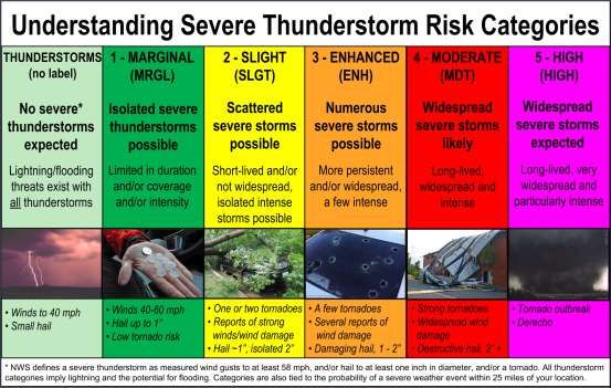
Section 5.4.3: Risk Assessment – Severe Storms

tornadoes, hurricanes, and tropical storms in Cayuga County. Historical data presented in Table 5.4.3-1 lists the
maximum extent of severe weather in Cayuga County.

Table 5.4.3-1. Severe Storm Extent in Cayuga County (1950 to 2020)
                                           Extent of Severe Storms in Cayuga County
                 Largest Hailstone on Record                                          2 inches
                Strongest Tornado on Record                                             F3
                Highest Wind Speed on Record                                          60 knots
            Strongest Tropical System on Record                                       Tornado
Source: NCEI 2018, NOAA Historical Hurricane Tracks 2018

Thunderstorms
Severe thunderstorm watches and warnings are issued by the local NWS office and the Storm Prediction Center
(SPC). The NWS and SPC will update the watches and warnings and notify the public when they are no longer
in effect. Watches and warnings for tornadoes in New York State are as follows:

     •    Severe Thunderstorm Warnings are issued when there is evidence based on radar or a reliable spotter
          report that a thunderstorm is producing, or forecast to produce, wind gusts of 58 mph or greater,
          structural wind damage, or hail one-inch in diameter or greater. A warning will include where the storm
          was located, what municipalities will be impacted, and the primary threat associated with the severe
          thunderstorm warning. After it has been issued, the NWS office will follow up periodically with Severe
          Weather Statements that contain updated information on the severe thunderstorm and advise the public
          when the warning is no longer in effect (NWS 2009d, NWS 2010c).
     •    Severe Thunderstorm Watches are issued by the SPC when conditions are favorable for the development
          of severe thunderstorms over a larger-scale region for a duration of at least three hours. Tornadoes are
          not expected in such situations, but isolated tornado development can also occur. Watches are normally
          issued well in advance of the actual occurrence of severe weather. During the watch, the NWS will keep
          the public informed on what is happening in the watch area and also advise public when the watch has
          expired or been cancelled (NWS 2009, NWS 2010).
     •    Special Weather State for Near Severe Thunderstorms are issued for strong thunderstorms that are below
          severe levels but still might have some adverse impacts. Usually, they are issued for the threat of wind
          gusts of 40 to 58 mph or small hail less than one-inch in diameter (NWS 2010).

Figure 5.4.3-1 presents the severe thunderstorm risk categories, as provided by the SPC.

          Hazard Mitigation Plan Update – Cayuga County, New York                                           5.4.3-3
          MONTH 2021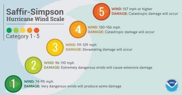
Section 5.4.3: Risk Assessment – Severe Storms

Figure 5.4.3-1. Severe Thunderstorm Risk Categories.

Source: NOAA SPC 2017

Lightning                                                             Figure 5.4.3-2. Hail Size Chart
Lightning is most often associated with moderate to severe
thunderstorms. The severity of lightning refers to the frequency
of lightning strikes during a storm. The New York City Office of
Emergency Management notes that lightning strikes occur with
moderate frequency in the State of New York, with 3.8 strikes
occurring per square mile each year. Multiple devices are
available to track and monitor the frequency of lightning
(NYSDHSES 2014).

Hailstorms
The severity of hail is measured by duration, hail size, and
geographic extent. Most hail stones from hailstorms are made up
of variety of sizes. Only the very largest hail stones pose serious
risk to people, if exposed (NYS DHSES 2019). The size of hail
is estimated by comparing it to a known object. The Tornado and
Storm Research Organization (TORRO) Hailstorm Intensity
Scale (H0 to H10) relates typical damage and hail sizes. Refer to
Appendix E (Supplementary Data) for a table that outlines the
TORRO scale.

High Winds
The following table provides the descriptions of winds and their associated sustained wind speed used by the
NWS during wind-producing events.

         Hazard Mitigation Plan Update – Cayuga County, New York                                        5.4.3-4
         MONTH 2021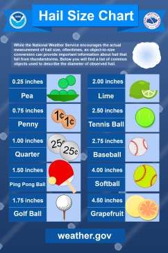
Section 5.4.3: Risk Assessment – Severe Storms

Table 5.4.3-2. NWS Wind Descriptions

                                             Sustained Wind Speed
            Descriptive Term                         (mph)
 Strong, dangerous, or damaging                        ≥40
 Very Windy                                           30-40
 Windy                                                20-30
 Breezy, brisk, or blustery                           15-25
 None                                             5-15 or 10-20
 Light or light and variable wind                      0-5
Source:   NWS 2010
mph       miles per hour

The NWS issues advisories and warnings for winds. Issuance is normally site-specific. High wind advisories,
watches, and warnings are products issued by the NWS when wind speeds can pose a hazard or are life
threatening. The criterion for each of these varies from state to state. According to the NWS (2018), wind
warnings and advisories for New York State are as follows:

     •    High Wind Warnings are issued when sustained wind speeds of 40 mph or greater lasting for one hour
          or longer or for winds of 58 mph or greater for any duration or widespread damage are possible.
     •    Wind Advisories are issues when sustained winds of 30 to 39 mph are forecast for one hour or longer,
          or wind gusts of 46 to 57 mph for any duration.
Tornadoes
The magnitude or severity of a tornado is categorized using the Enhanced Fujita Tornado Intensity Scale (EF
Scale). This is the scale now used exclusively for determining tornado ratings by comparing wind speed and
actual damage. Figure 5.4.3-3 illustrates the relationship between EF ratings, wind speed, and expected tornado
damage.

          Hazard Mitigation Plan Update – Cayuga County, New York                                      5.4.3-5
          MONTH 2021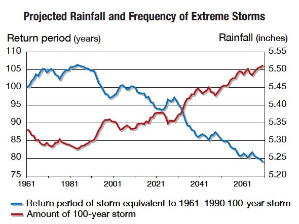
Section 5.4.3: Risk Assessment – Severe Storms

Figure 5.4.3-3. Explanation of EF-Scale Ratings

Source: Cornell University 2018

Tornado watches and warning are issued by the local NWS office. A tornado watch is released when tornadoes
are possible in an area. A tornado warning means a tornado has been sighted or indicated by weather radar. The
current average lead time for tornado warnings is 13 minutes. Occasionally, tornadoes develop so rapidly, that
little, if any, advance warning is possible (FEMA 1997).

Hurricanes/Tropical Storms
The extent of a hurricane or tropical storm is commonly categorized in accordance with the Saffir-Simpson
Hurricane Wind Scale, which assigns a designation of tropical storm for storms with sustained wind speeds
below 74 mph and a hurricane category rating of 1–5 based on a hurricane’s increasing sustained wind speed.
This scale estimates potential property damage. Hurricanes reaching Category 3 and higher are considered major
hurricanes because of their potential for significant loss of life and damage. Tropical Storms and Category 1 and
2 storms are still dangerous and require preventative measures (NOAA 2013). Figure 5.4.3-4 presents this scale,
which is used to estimate the potential property damage and flooding expected when a hurricane makes landfall.

          Hazard Mitigation Plan Update – Cayuga County, New York                                        5.4.3-6
          MONTH 2021
Section 5.4.3: Risk Assessment – Severe Storms
Figure 5.4.3-4. The Saffir-Simpson Scale
Source: Disaster Readiness Portal 2017
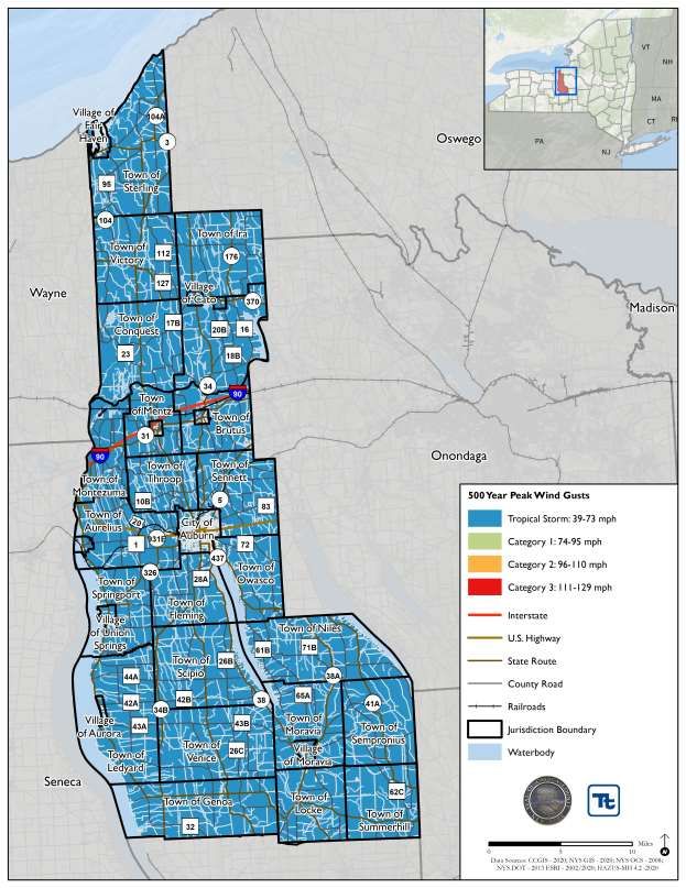
Peak wind speed projections were generated using Hazus-MH v4.2. Hazus estimated the maximum 3-second
gust wind speeds for Cayuga County to be below 39 mph for the 100-year MRP event and not strong enough to
be considered a tropical storm. The maximum 3-second gust wind speeds for Cayuga County range from 39 to
73 mph for the 500-year MRP event (tropical storm). Hazus did not generate the hurricane track for the 100- and
500-year probabilistic events. The associated impacts and losses from these 100-year and 500-year MRP
hurricane event model runs are reported in the Vulnerability Assessment. Figure 5.4.3-5 shows the estimated
maximum 3-second gust wind speeds that can be anticipated in the study area associated with the 500-year MRP
events.
Hazard Mitigation Plan Update – Cayuga County, New York 5.4.3-7
MONTH 2021Section 5.4.3: Risk Assessment – Severe Storms
Figure 5.4.3-5. Wind Speeds for the 500-Year MRP Event
Hazard Mitigation Plan Update – Cayuga County, New York 5.4.3-8
MONTH 2021Section 5.4.3: Risk Assessment – Severe Storms
Previous Occurrences and Losses
Many sources have provided historical information regarding previous occurrences and losses associated with
severe storm events in Cayuga County. According to NOAA-NCEI Storm Events Database, Cayuga County has
been impacted by 307 severe storm events that caused no fatalities, 20 injuries, $6.973 million in property
damage, and $2,000 in crop damage.
Table 5.4.3-3. Severe Storm Events 1954-2020
Number of
Occurrences
Between 1954 and Total Total Total Property Total Crop
Hazard Type 2020 Fatalities Injuries Damage ($) Damage ($)
Funnel Cloud 4 0 0 $0 $0
$1.08
Hail 84 0 0 $209,000
million
Heavy Rain 18 0 0 $0 $0
High Wind 51 0 0 $1.6 million $0
Hurricane* 2 0 0 $0 $0
Lightning 7 0 3 $57,000 $0
Strong Wind 2 0 0 $10,000 $0
Thunderstorm Wind 267 0 3 $27.6 million $1.1 million
Tornado 5 1 0 $3.2 million $0
Tropical Depression* 0 0 0 $0 $0
Tropical Storm* 1 0 0 $0 $0
TOTAL 441 1 6 $32.6 million $2.2 million
Source: NOAA-NCEI 2020; NHC 2020
* Number of events were collected from NHC and includes events that occurred within 65 nautical miles of Cayuga County.
M: Million, K: Thousand
FEMA Disaster Declarations
Between 1954 and 2020, New York State was included in 41 FEMA declared severe storm-related major disaster
declarations (DR) or emergencies (EM) classified as one or a combination of the following hazards: hurricanes,
floods, severe storm, high tides, tropical storm, high winds, wave action, and landslides. Of those declarations,
Cayuga County was included in 12 declarations (FEMA 2020). Table 5.4.3-4 lists FEMA DR and EM
declarations for Cayuga County.
Table 5.4.3-4. Severe Storm-Related FEMA Declarations for Cayuga County, 1954 to 2020
FEMA Declaration
Number Date(s) of Event Event Type Details
DR-26 October 7, 1954 Hurricane Hurricanes
DR-45 August 22, 1955 Hurricane Hurricane and Floods
DR-129 March 16, 1962 Flood Severe Storm, High Tides and Flooding
DR-158 August 23, 1968 Flood Heavy Rains and Flooding
DR-338 June 2, 1972 Tropical Storm Tropical Storm Agnes
DR-367 March 21, 1973 Storm High Winds, Wave Action and Flooding
DR-487 October 2, 1975 Severe Storm Storms, Rains, Landslides and Flooding
DR-1095 January 24, 1996 Severe Storm Severe Storms and Flooding
DR-1244 September 7, 1998 Severe Storm NY – Severe Weather
DM-1534 August, 2004 Severe Storm Severe Storm and Flooding
DM-3262 August 3, 2005 Hurricane Hurricane Katrina Evacuation
Hazard Mitigation Plan Update – Cayuga County, New York 5.4.3-9
MONTH 2021Section 5.4.3: Risk Assessment – Severe Storms
FEMA Declaration
Number Date(s) of Event Event Type Details
DM-1589 April 19, 2005 Severe Storm Severe Storm and Flooding
EM-3351 October 28, 2012 Hurricane Hurricane Sandy
Source: FEMA 2020
USDA Declarations
The US Department of Agriculture, or USDA has a separate disaster declaration system that is used to document
and record agriculture-related loss due to extreme weather events (USDA, 2020). Regarding severe storm
disaster declarations in Cayuga County, 1 high-wind event was recorded in 2014, 1 Hurricane/ Tornado event in
2015, and 3 high-wind events in 2016. There were no events recorded in Cayuga County for the years of 2017,
2018, 2019, and 2020 (up to the month of November).
Previous Events
Figure 5.4.3-6. from the NOAA Historical Hurricane Tracker illustrates the tracks of storms between 1842 and
2020 within 65 miles of Cayuga County. Cayuga County is not frequently impacted by hurricanes, tropical
storms, or tropical depressions but has recently experienced the direct and indirect landward effects associated
with Extratropical Storm Nate in 2017. Please note that the figure does not show Hurricane Sandy passing within
65 nautical miles of the county.
Figure 5.4.3-6. Historical Hurricane Tracks within 65 miles of Cayuga County, 1842 to 2020
Source: NOAA Historical Hurricane Tracks 2020
Hazard Mitigation Plan Update – Cayuga County, New York 5.4.3-10
MONTH 2021Section 5.4.3: Risk Assessment – Severe Storms
The NOAA NCEI Storm Events database records severe storm events. For this HMP update, known severe storm
events that have impacted Cayuga County between 2014 and 2020 are identified in Table 5.4.3-5. With severe
storm documentation for New York State and Cayuga County being extensive, not all sources have been
identified or researched. Therefore, Table 5.4.3-5 might not include all events that have occurred in the county.
For events prior to 2014, refer to Appendix E (Supplementary Data). For detailed information on damages and
impacts to each municipality, refer to Section 9 (Jurisdictional Annexes).
Hazard Mitigation Plan Update – Cayuga County, New York 5.4.3-11
MONTH 2021Section 5.4.3: Risk Assessment – Severe Storms
Table 5.4.3-5. Severe Storm Events in Cayuga County, 2014 to 2020
FEMA
Declaration
Number County
Dates of Event Event Type** (if applicable) Designated? Event Details*
January 6, 2014 High Wind N/A A sharp cold front crossed the region during the overnight/early morning hours. For a brief
period in the wake of the front winds increased across the region. The winds gusted as high
N/A as 60 miles per hour. In Cayuga County, downed trees and power lines were reported from
Chili Center, Covington, Hamburg, Victory, Dansville and Belmont. Estimated property
damage in the county was $10,000.
June 13, 2014 Thunderstorm Wind N/A N/A A cold front brought thunderstorms as it crossed the region. The thunderstorm winds
downed trees on Route 34 in Ira and in Granby Center. Estimated property damage in the
county was $15,000.
June 24, 2014 Thunderstorm Wind N/A N/A Showers and thunderstorms developed across the region in a warm, humid air mass during
the afternoon hours as a cold front approached from the west. Several of the thunderstorms
produced strong, damaging winds. Damage was mainly reported as downed trees and wires
however there were limited reports of structural damage in Fulton. Estimated property
damage in the county was $10,000.
August 2, 2014 Thunderstorm Wind N/A N/A Surface boundaries from prior convection and a lake breeze allowed thunderstorms to
develop across central New York in an unstable airmass. Two severe thunderstorms
occurred both producing large hail. Estimated property damage in the county was $10,000.
June 12, 2015 Thunderstorm Wind N/A N/A A very unstable air mass was present Friday afternoon and evening as a warm front lifted
north that morning across the state of Pennsylvania and New York. A shortwave aloft which
was embedded within the cyclonic flow interacted with this front and showers and
thunderstorms developed over central New York. Late Friday afternoon the front started to
slowly shift southward as a cold front. Showers and thunderstorms continued to develop
along the front into the late evening hours as it moved southward into Pennsylvania. These
storms produced damaging winds and large hail. Estimated property damage in the county
was $23,000.
July 7, 2015 Thunderstorm Wind N/A N/A Thunderstorms accompanied the passage of a cold front across the region. Thunderstorm
winds produced wind gusts which downed trees and power lines. Damage was reported in
Spencerport, Elma, Friendship, Wellsville, and Weedsport. In Sunset Bay, the thunderstorm
wind downed a 50-foot tree which crushed a cottage and flattened two cars. Six people in
the cottage at the time escaped unharmed. Winds were estimated near 60 mph. Estimated
property damage in the county was $10,000.
August 4, 2015 Thunderstorm Wind N/A N/A Showers and thunderstorms moved across the northern Finger Lakes Region. One of the
thunderstorms produced one inch hail in Port Byron. The thunderstorm winds of the storm
downed trees on Shotwell and McClellan Streets in Port Byron. Estimated property damage
in the county was $20,000.
August 18, 2015 Thunderstorm Wind N/A N/A Thunderstorms developed during the late afternoon hours on lingering boundaries from
thunderstorms earlier in the day. The thunderstorms produced damaging winds and that
downed trees and wires from Wayne to Oswego Counties. Isolated storms also downed trees
and wires in Harrisville in Lewis county. Damage was reported near the towns of Ontario,
Hazard Mitigation Plan – Cayuga County, New York 5.4.3-12
MONTH 2020Section 5.4.3: Risk Assessment – Severe Storms
FEMA
Declaration
Number County
Dates of Event Event Type** (if applicable) Designated? Event Details*
Caughdenoy, Central Square, Fulton and Scriba. Multiple trees were downed on the State
University of New York Oswego campus. At Cross Lake Park, east of Cato, several
recreational vehicles were damaged by falling trees and limbs while a few were overturned
by the strong winds. Docks in Cross Lake broke loose with multiple boats being damaged.
Winds gusts were generally estimated around 60 mph but approaching 70 mph at Cross
Lake Park. Estimated property damage in the county was $103,000.
January 10, 2016 High Wind N/A N/A On Sunday, January 10th, deep low pressure crossed Ohio during the morning, southern
Ontario through the day, reaching Quebec Sunday evening. The system dragged a cold front
across the region during the late afternoon hours. Ahead of the cold front, southeast wind
resulted in downslope wind off the Chautauqua Ridge. Wind gusts were measure to 66 mph
at Dunkirk. Also, ahead of the front, southeast winds channeled down the Black River
valley. Across the entire south shore of Lake Ontario, winds increased following the front.
The strong winds brought down trees and power lines. Utilities reported thousands without
power scattered throughout the region. Some of the falling trees damaged homes and
automobiles. Estimated property damage in the county was $25,000.
June 20, 2016 Thunderstorm Wind N/A N/A Thunderstorms developed ahead of an approaching cold front. The first round of storms
developed across southern Ontario just west of the St. Lawrence River and moved east
across Jefferson and northern Lewis counties producing fairly widespread wind damage. A
second line formed near the Buffalo area. This line produced a few sporadic wind damage
reports near Buffalo. As this line progressed southeast of Buffalo, the storms intensified
producing a corridor of widespread damage. Outside of these two lines, a few more isolated
severe storms developed and produced wind damage. Damage consisted mostly of downed
trees and power lines. In some cases roads were blocked and closed by downed trees. In
Delevan, a large tree damaged two trailers. In Shaw Bay, Oswego County, a dock was
flipped over by the thunderstorm winds. Several of the storms produced half inch to three
quarter inch hail near Clarence, Orchard Park, Brighton, Oswego, and Chaffee. Estimated
property damage in the county was $15,000.
July 18, 2016 Thunderstorm Wind N/A N/A Thunderstorms developed over Lake Erie and southern Ontario ahead of a slow moving cold
front. The storm moved across the Genesee Valley intensifying as they reached the Finger
Lakes and North Country. The storms produced damaging winds that downed trees and
power lines. Estimated property damage in the county was $16,000.
January 11, 2017 High Wind N/A N/A Gusty winds accompanied the passage of a deepening storm system crossing the upper Great
Lakes. Wind gusts were measured to 64 mph at Dunkirk, Batavia and Niagara Falls Airport.
Other wind gusts included: 60 mph at Buffalo Airport and 58 mph at Fort Drum and
Rochester Airport. The strong winds downed trees and power lines. Several thousand
customers were without power. Numerous roads were closed because they were blocked by
fallen trees. Structural damage was reported in Buffalo and Cheektowaga as roofs were
blown off the Buffalo Motor and Generator Corporation and the gymnasium of a school.
There was also damage reported to several home and cars caused by falling trees. The
Hazard Mitigation Plan – Cayuga County, New York 5.4.3-13
MONTH 2020Section 5.4.3: Risk Assessment – Severe Storms
FEMA
Declaration
Number County
Dates of Event Event Type** (if applicable) Designated? Event Details*
Skyway in Buffalo was closed for several hours due to the wind conditions making travel on
the elevated span unsafe. Estimated property damage in the county was $50,000.
March 2, 2017 High Wind N/A N/A Strong winds followed the passage of a cold front across the area. The winds increased
during the evening hours of March first before subsiding by daybreak on the second. Gusts
as high as 64 mph were measured. The strong winds downed trees and power lines
throughout the region. The wind damaged several buildings including ones in: Batavia (gas
station canopy knocked over), North Collins (roof off trailer on the Seneca Nation), and
Akron. Falling trees damaged homes or automobiles in: Rochester (on North Clinton
Avenue), Blasdell, Webster, Portageville and Irondequoit. Measured wind gusts included:
64 mph at Rochester Airport, 62 mph at Oswego Airport and near Warsaw, 61 mph in
Boston and near Batavia, and 58 mph near Fredonia. Estimated property damage in the
county was $15,000.
March 8, 2017 High Wind N/A N/A Unusually deep low pressure moved from northwest Ontario across Hudson Bay. The low
brought strong winds to the entire region with sustained winds up to 49 mph and wind gusts
as high as 81 mph. A significant amount of damage resulted with hundreds of thousands left
without power. Particularly hard hit was the northern Genesee Valley region including parts
of Orleans, Monroe, and Genesee counties. Trees and power lines were downed. Power
poles were snapped. The strong winds derailed a train in Batavia (Genesee County). Twelve
out of thirty-one freight cars were blown off the tracks. In Chili, a large section of fence
was impaled into the second story of a house. Numerous flights into the Buffalo and
Rochester Airports had to be diverted due to the winds. This in turn resulted in cancellation
of some outbound flights from those airports. Estimated property damage in the county was
$75,000.
Thunderstorm Wind N/A N/A Under the influence of a warm, moist airmass, thunderstorms developed across western and
north-central New York. A severe multi-cell cluster of storms over northeast Pennsylvania,
tracked northeast forming a line of thunderstorms that moved across the region from
June 18, 2017 Chautauqua County to Lewis County during the afternoon and early evening hours. Law
enforcement reported trees and wires downed by thunderstorm winds. Several roads were
partially or completely blocked by debris from the falling trees. Estimated property damage
in the county was $12,000.
August 4, 2017 Thunderstorm Wind N/A N/A A strong cold front moved across the northeast as a surface low pressure system moved
toward Quebec Friday morning. By Friday afternoon, a pre-frontal trough developed across
New York and Pennsylvania, leading to thunderstorms in a very unstable atmosphere. As
these storms propagated eastward, some became severe producing damaging winds.
Estimated property damage in the county was $10,000.
August 22, 2017 Thunderstorm Wind N/A N/A Three waves of severe storms moved across western and north-central NY making for an
almost 8-hour severe event. The first thunderstorms which developed over northeast Ohio
and northwest Pennsylvania moved across the western southern tier. The second round of
thunderstorms developed mid-afternoon again across the western southern tier. These
storms then moved across western New York to the eastern Lake Ontario region. The third
Hazard Mitigation Plan – Cayuga County, New York 5.4.3-14
MONTH 2020Section 5.4.3: Risk Assessment – Severe Storms
FEMA
Declaration
Number County
Dates of Event Event Type** (if applicable) Designated? Event Details*
wave of storms developed along an advancing cold front during the evening hours over the
Niagara Peninsula then moving across western New York. Estimated property damage in the
county was $10,000.
October 15, 2017 Thunderstorm Wind N/A N/A A line of severe thunderstorms moved across central New York during the early evening
hours of the 15th. The storms produced locally damaging wind gusts with trees and wires
down across several counties in central New York. Estimated property damage in the county
was $50,000.
October 30, 2017 High Wind N/A N/A Low pressure across the mid-Atlantic rapidly intensified as it tracked across central New
York. The winds were especially strong along the Lake Ontario shoreline counties. The
winds downed trees and power lines. Some structural damage was reported. There were
reports road closures due to downed limbs and wires. Several tens of thousands were
without power due to scattered outages. Wind gusts were measured to 71 mph at Oswego.
Estimated property damage in the county was $15,000.
April 4, 2018 High Wind N/A N/A An intense storm system tracked across the eastern Great Lakes region during the early
morning hours of the 4th and then down the Saint Lawrence River Valley during the day and
evening of the 4th. Strong winds behind this system spread across a large part of northern
and western New York State including the Finger Lakes region of upstate New York from
the late morning into the early evening. Numerous locations had wind gusts approaching 60
mph with trees and wires down in many locations. A church suffered some roof damage in
the Greater Syracuse area. The wind gusts peaked during the late afternoon hours of the 4th
before subsiding after sunset. Estimated property damage in the county was $20,000.
July 16, 2018 Thunderstorm Wind N/A N/A An upper level disturbance moved across New York State and triggered severe
thunderstorms the evening of the 16th. Estimated property damage in the county was
$15,000.
February 25, High Wind N/A N/A Low pressure over the central Plains rapidly deepened as it moved into the central Great
2019 Lakes, ending up as a 970 mb low over western Quebec. A strong cold front trailing the low
sliced through western New York trailing it and ushering in very gusty winds. The track of
the strong surface low was a classic high wind track for our region. Strong cold advection
and subsidence behind the cold front allowed post-frontal winds to mix down to the surface,
and the 1.5 PVU surface descending down to at least 500 mb, indicative of steepening lapse
rates. The wind aloft was extremely strong with 70-80 knots just off the deck. Estimated
property damage in the county was $10,000.
May 25, 2019 Thunderstorm Wind N/A N/A A line of showers and thunderstorms moved through portions of the western Southern Tier
and Finger Lakes regions of NY during the evening of the 25th. These severe thunderstorms
caused mainly tree damage in portions of Steuben, Yates, and southern Cayuga counties.
Estimated property damage in the county was $10,000.
July 16, 2019 Thunderstorm Wind N/A N/A A mid-level short wave moving over portions of Central New York sparked showers and
thunderstorms during the afternoon and early evening of the 16th. Some of these storms
became severe and caused mainly tree and power line damage. Estimated property damage
in the county was $10,000.
Hazard Mitigation Plan – Cayuga County, New York 5.4.3-15
MONTH 2020Section 5.4.3: Risk Assessment – Severe Storms
FEMA
Declaration
Number County
Dates of Event Event Type** (if applicable) Designated? Event Details*
August 8, 2019 Thunderstorm Wind N/A N/A A cold front and moved through Central New York during the afternoon of the 8th. This
sparked a line of severe thunderstorms across the area, mainly ahead of the front. Estimated
property damage in the county was $10,000.
August 16, 2019 Thunderstorm Wind N/A N/A A fast moving upper level short wave moved through portions of Central New York during
the evening of the 16th. This sparked a few strong to severe thunderstorms across the area.
Estimated property damage in the county was $10,000.
October 31, 2019 High Wind N/A N/A A deepening area of consolidated low pressure tracked from the north shoreline of Lake Erie
to Toronto, and then along the northern shoreline of Lake Ontario Thursday evening,
October 31st. This system brought recorded breaking Halloween rains to the region,
damaging wind gusts, a large Lake Erie seiche, a smaller Lake Ontario seiche, and river
flooding in the North Country (Cayuga, Black and Moose River). Estimated property
damage in the county was $20,000.
Source(s): FEMA 2018; NOAA-NCDC 2018; NYS HMP 2014
* Many sources were consulted to provide an update of previous occurrences and losses; event details and loss/impact information may vary and has been summarized in the above table
** Only thunderstorm wind events with property damages of $10K or greater are listed. There were 26 days of thunderstorm winds with 59 individual reports and a total of $359,000 in property
damages.
FEMA Federal Emergency Management Agency
HMP Hazard Mitigation Plan
NCDC National Climatic Data Center
NOAA National Oceanic and Atmospheric Administration
NWS National Weather Service
NYS New York State
K =$1,000
Hazard Mitigation Plan – Cayuga County, New York 5.4.3-16
MONTH 2020Section 5.4.3: Risk Assessment – Severe Storms
Climate Change Projections
Cayuga County is located in ClimAID Climate Region 1 (Western New York and the Great Lakes Plain).
Projected impacts of climate change to this region includes relatively low rainfall and increased summer drought
risk. Table 5.4.3-6 displays the projected seasonal precipitation change by the 2050s, by season, for ClimAID
Climate Region 1 (NYSERDA 2014).
Table 5.4.3-6. Projected Seasonal Precipitation Change in Region 1, 2050s (% change)
Winter Spring Summer Fall
+5 to +15 0 to +10 -10 to +10 -5 to +10
Source: NYSERDA 2014
The projected increase in precipitation is expected to fall in heavy downpours and less in light rains. Downpours
are very likely to increase in frequency and intensity, a change that has the potential to affect drinking water
through flooding contaminating wells; heighten the risk of riverine flooding; flood key rail lines, roadways, and
transportation hubs; and increase delays and hazards related to extreme weather events (NYSERDA 2014). Less
frequent rainfall during the summer months can the ability of water supply systems to provide water. Increasing
water temperatures in rivers and streams will affect aquatic health and reduce the capacity of streams to
assimilate effluent wastewater treatment plants and industrial discharges (NYSERDA 2014).
Figure 5.4.3-7. displays the projected rainfall and frequency of extreme storms in New York State. The amount
of rainfall in a 100-year event is projected to increase, while the number of years between such storms (return
period) is projected to decrease. Rainstorms will become more severe and more frequent (NYSERDA 2011).
Figure 5.4.3-7. Projected Rainfall and Frequency of Extreme Storms
Source: NYSERDA 2014
Probability of Future Occurrences
Table 5.4.3-7. summarizes data regarding the probability of occurrences of severe storm events in Cayuga
County based on the historic record. Thunderstorm events are the most common in Cayuga County, followed by
high wind events. The information used to calculate the probability of occurrences is based solely on NOAA-
NCEI storm events database results.
Hazard Mitigation Plan Update – Cayuga County, New York 5.4.3-17
MONTH 2021Section 5.4.3: Risk Assessment – Severe Storms
Table 5.4.3-7. Probability of Future Occurrence of Severe Storm Events
Number of Occurrences Between % chance of occurrence in any
Hazard Type 1954 and 2020 given year
Funnel Cloud 4 5.9%
Hail 84 100%
Heavy Rain 18 26.9%
High Wind 51 76.1%
Hurricane* 2 3%
Lightning 7 10.5%
Strong Wind 2 3%
Thunderstorm Wind 267 100%
Tornado 5 7.5%
Tropical Depression* 0 0%
Tropical Storm* 1 1.5%
TOTAL 441 100%
Source: NOAA-NCEI 2020; NHC 2020
* Number of events were collected from NHC and includes events that occurred within 65 nautical miles of Cayuga County.
Cayuga County is expected to continue experiencing direct and indirect impacts of severe storms annually. These
storms may induce secondary hazards such as flooding and utility failure. In Section 5.3 (Hazard Ranking), the
identified hazards of concern for Cayuga County were ranked. The probability of occurrence, or likelihood of
the event, is one parameter used for hazard rankings. Based on historical records and input from the Planning
Committee, the probability of occurrence for severe storms in the county is considered frequent (event has 100
percent annual probability and might occur multiple times per year).
5.4.3.2 Vulnerability Assessment
To understand risk, a community must evaluate what assets are exposed and vulnerable in the identified hazard
area. For severe storms, the entirety of Cayuga County has been identified as the hazard area. Therefore, all
assets in the County (population, structures, critical facilities and lifelines), as described in the County profile,
are vulnerable. Potential losses associated with high-wind events were calculated for the County for two
probabilistic hurricane events: the 100-year and 500-year MRP hurricane events. The impacts on population,
existing structures, critical facilities and the economy are presented below.
Impact on Life, Health and Safety
The impact of a severe weather event and wind on life, health and safety is dependent upon several factors including
the severity of the event and whether adequate warning time was provided to residents. Hazus estimates that zero
persons will be displaced from their homes or will seek shelter during a 100-year or 500-year MRP hurricane wind
event. Secondary impacts caused by extreme wind events include downed trees, damaged buildings, and debris
carried by high winds, which can lead to injury or loss of life.
Socially vulnerable populations are most susceptible, based on a number of factors including their physical and
financial ability to react or respond during a hazard and the location and construction quality of their housing.
Vulnerable populations include homeless persons, elderly (over 65 years old), low income or linguistically
isolated populations, people with life-threatening illnesses, and residents living in areas that are isolated from
major roads. According to the 5-year 2018 American Community Survey Population Estimates, there are 13,859
persons over 65 years old and 8,563 persons living below the poverty level in Cayuga County.
Hazard Mitigation Plan Update – Cayuga County, New York 5.4.3-18
MONTH 2021Section 5.4.3: Risk Assessment – Severe Storms
Additionally, people located outdoors (i.e., recreational activities and farming) are considered most vulnerable
to hailstorms, thunderstorms and tornadoes. This is because there is little to no warning and shelter may not be
available. Moving to a lower risk location will decrease a person’s vulnerability. Refer to Section 4 (County
Profile) for population statistics for each participating jurisdiction.
Impact on General Building Stock
As discussed in Table 5.4.3-3 several thousand dollars of reported damages have occurred in Cayuga County
due to severe storm events. Damage to buildings is dependent upon several factors including wind speed, wind
duration, presence of hail stones or lightning, and building construction.
After considering the population exposed to the severe storm hazard, the general building stock replacement
value exposed to and damaged by 100- and 500-year MRP events was examined. Wind-only impacts from a
severe storm are reported based on the probabilistic model in Hazus. Potential damage is the modeled loss that
could occur to the exposed inventory, including damage to structural and content value based on the wind-only
impacts associated with a hurricane.
It is assumed that the entire County’s general building stock is exposed to the severe storm wind hazard (greater
than $31 billion). Estimated building damage was evaluated by Hazus across the following wind damage
categories: no damage/very minor damage, minor damage, moderate damage, severe damage, and total
destruction. Table 5.4.3-8 summarizes the definitions of the damage categories.
Table 5.4.3-8. Description of Damage Categories
Roof Window Missile Roof Wall
Qualitative Damage Cover Door Roof Impacts on Structure Structure
Description Failure Failures Deck Walls Failure Failure
No Damage or Very Minor ≤2% No No No No No
Damage
Little or no visible damage
from the outside. No broken
windows, or failed roof deck.
Minimal loss of roof over,
with no or very Limited water
penetration.
Minor Damage >2% and One No 15% and > one and ≤ 1 to 3 Typically No No
Major roof cover damage, ≤50% the larger of panels 5 to 10
moderate window breakage. 20% & 3 impacts
Minor roof sheathing failure.
Some resulting damage to
interior of building from
water.
Severe Damage >50% > the larger >3 and Typically No No
Major window damage or roof of 20% & 3 ≤25% 10 to 20
sheathing loss. Major roof and ≤50% impacts
cover loss. Extensive damage
to interior from water.
Destruction Typically >50% >25% Typically Yes Yes
Hazard Mitigation Plan Update – Cayuga County, New York 5.4.3-19
MONTH 2021Section 5.4.3: Risk Assessment – Severe Storms
Roof Window Missile Roof Wall
Qualitative Damage Cover Door Roof Impacts on Structure Structure
Description Failure Failures Deck Walls Failure Failure
Complete roof failure and/or, >50% >20
failure of wall frame. Loss of impacts
more than 50% of roof
sheathing.
Source: Hazus-MH Hurricane Technical Manual
For the 100-year MRP event, Hazus estimates $0 in structure damage. As Table 5.4.3-3 indicates, there have
been recent severe storm impacts. Therefore, the Hazus results may underestimate the potential loss to the
County as a result of a wind event.
Hazus estimates $84,369 in building damages (less than 1-percent of the county’s total building inventory) as a
result of the 500-year MRP event’s tropical storm peak gust wind speeds (45.7 to 52.4 mph). Residential
buildings account for 100-percent of the total damage. Table 5.4.3-9. summarizes the building damage
estimated for the 500-year MRP wind event by municipality. The Town of Locke will experience the greatest
loss with $35,816 of replacement cost value damages.
Table 5.4.3-9. Damage State Categories for Buildings During 100-Year and 500-Year MRP Hurricane
Wind Event in Cayuga County
Percent of Total
Building and Estimated
Estimated
Total Contents Residential
Total Damages
Replacement Replacement Cost Damages
Jurisdiction Value
Cost Value (All
Occupancies)
500-Year 500-Year 500-Year
Auburn (C) $6,999,332,587 $0 0.0% $0
Aurelius (T) $1,560,055,153 $0 0.0% $0
Aurora (V) $310,613,500 $0 0.0% $0
Brutus (T) $871,216,831 $0 0.0% $0
Cato (T) $936,009,732 $0 0.0% $0
Cato (V) $142,410,826 $0 0.0% $0
Cayuga (V) $151,243,344 $0 0.0% $0
Conquest (T) $767,481,301 $0 0.0% $0
Fair Haven (V) $330,091,747 $0 0.0% $0
Fleming (T) $1,024,193,487 $0 0.0% $0
Genoa (T) $1,445,252,239 $0 0.0% $0
Ira (T) $891,072,727 $0 0.0% $0
Ledyard (T) $958,919,041 $0 0.0% $0
Locke (T) $633,096,125 $35,816Section 5.4.3: Risk Assessment – Severe Storms
Percent of Total
Building and Estimated
Estimated
Total Contents Residential
Total Damages
Replacement Replacement Cost Damages
Jurisdiction Value
Cost Value (All
Occupancies)
500-Year 500-Year 500-Year
Owasco (T) $1,268,899,319 $0 0.0% $0
Port Byron (V) $242,486,497 $0 0.0% $0
Scipio (T) $1,272,634,315 $0 0.0% $0
Sempronius (T) $353,998,820 $21,201Section 5.4.3: Risk Assessment – Severe Storms
Impacts to transportation lifelines affect both short-term (e.g., evacuation activities) and long-term (e.g., day-to-
day commuting and goods transport) transportation needs. Utility infrastructure (power lines, gas lines, electrical
systems) could suffer damage and impacts can result in the loss of power, which can impact business operations
and can impact heating or cooling provision to the population.
Hazus estimates the total economic loss associated with the 100-year and the 500-year MRP hurricane wind
event (direct building losses and business interruption losses). Direct building losses are the estimated costs to
repair or replace the damage caused to the building. This is reported in the “Impact on General Building Stock”
section discussed earlier. Business interruption losses are the losses associated with the inability to operate a
business because of the wind damage sustained during the storm or the temporary living expenses for those
displaced from their home because of the event. Hazus estimates that there are no economic losses for Cayuga
County caused by the 100-year MRP hurricane wind event. Refer to Table 5.4.3-10 for a summary of Hazus
estimated economic losses for Cayuga County caused by the 100-year and the 500-year MRP hurricane wind
events.
Table 5.4.3-10. Estimated Economic Losses for the 100-Year and 500-Year Mean Return Period
Hurricane Wind Events
Building and
Mean Return Inventory Relocation
Content Wages Losses Rental Losses Income Losses
Period (MRP) Loss Loss
Losses
100-year MRP $0 $0 $0 $0 $0 $0
500-year MRP $0 $0 $84,370 $0 $0 $0
Sources: Hazusv4.2; Cayuga County GIS 2020; RS Means 2019
Hazus also estimates the amount of building and tree debris that may be produced as result of the 100- and 500-
year MRP wind events. For the 100-year and 500-year MRP wind events, Hazus estimates 0 tons of debris.
Because the estimated debris production does not include flooding, this is likely a conservative estimate and may
be higher if multiple impacts occur.
Impact on the Environment
The impact of severe weather events on the environment varies, but researchers are finding that the long-term
impacts of more severe weather can be destructive to the natural and local environment. National organizations
such as USGS and NOAA have been studying and monitoring the impacts of extreme weather phenomena as it
impacts long term climate change, streamflow, river levels, reservoir elevations, rainfall, floods, landslides,
erosion, etc. (USGS 2020). For example, severe weather that creates longer periods of rainfall can erode natural
banks along waterways and degrade soil stability for terrestrial species. Tornadoes can tear apart habitats causing
fragmentation across ecosystems. Researchers also believe that a greater number of diseases will spread across
ecosystems because of impacts that severe weather and climate change will have on water supplies (NOAA
2013). Overall, as the physical environment becomes more altered, species will begin to contract or migrate in
response, which may cause additional stressors to the entire ecosystem within Cayuga County.
Cascading Impacts to Other Hazards
Severe weather events and severe wind events can escalate the impacts of flooding and severe winter weather.
Severe weather may carry extreme rainfall that could exacerbate flooding and could increase the intensity of
snow and blizzard events. More information about flooding and severe winter storm can be found in Section
5.4.2 and Section 5.4.4, respectively.
Hazard Mitigation Plan Update – Cayuga County, New York 5.4.3-22
MONTH 2021Section 5.4.3: Risk Assessment – Severe Storms
Future Changes That May Impact Vulnerability
Understanding future changes that affect vulnerability in the County can assist in planning for future
development and ensure establishment of appropriate mitigation, planning, and preparedness measures. Changes
in the natural environment and built environment and how they interact can also provide insight about ways to
plan for the future.
Projected Development
Any areas of growth could be potentially impacted by the severe storm hazard because the entire County is
exposed and vulnerable to the wind hazard associated with severe storms. However, due to increased standards
and codes, new development may be less vulnerable to the severe storm hazard compared to the aging building
stock in the County.
Projected Changes in Population
Estimated population projections provided by the 2017 Cornell Program on Applied Demographics indicates
that Cayuga’s population will continue to decrease into 2040, reducing total population to approximately 66,111
persons (Cornell Program on Applied Demographics, 2017). While less people will reside in the County, those
that remain are still vulnerable to severe weather and severe wind events. Refer to Section 4 (County Profile)
for additional discussion on population trends.
Climate Change
As displayed in Figure 5.4.3-7, the entire State of New York is projected to experience an increase in the
frequency and severity of extreme storms and rainfall. The northeast region of the United States has experienced
a greater increase in extreme precipitation than any other region in the U.S. between 1958 and 2010, the
Northeast experienced more than 70% increase in the amount of precipitation falling in rain events (NCA, 2014).
Refer to Section 5.4.2 (Flood) for a discussion related to the impact of climate change due to increases in rainfall.
An increase in storms will produce more wind events and may increase tornado activity. Additionally,
thunderstorms and increase in temperature can relate to the strength of a storm resulting in tornadoes (NOAA,
2020). With an increased likelihood of strong winds and tornado events, all of the County’s assets will
experience additional risk for losses as a result of extreme wind events.
Changes in Vulnerability Since the 2014 HMP
Since the 2014 analysis, population statistics have been updated using the 5-Year 2014-2018 American
Community Survey Population Estimates. The general building stock was also updated using RS Means 2019
building valuations that estimated replacement cost value for each building in the inventory, updated building
footprints and critical facilities were provided and reviewed by Cayuga County. The updated building stock
inventory was imported into Hazus-MH v4.2 to complete a hurricane wind analysis for the 100-year and 500-
year MRP hurricane wind event. Overall, this vulnerability assessment uses a more accurate and updated
building inventory which provides more accurate estimated exposure and potential losses for Cayuga County.
Overall, this vulnerability assessment uses a more accurate and updated building inventory which provides more
accurate estimated exposure and potential losses for Cayuga County.
Identified Issues
Important issues associated with severe storms in the planning area include the following:
• Downed powerlines caused by tree or debris falling on wires lead to power outages throughout the
County, leaving residents without access to communication services.
Hazard Mitigation Plan Update – Cayuga County, New York 5.4.3-23
MONTH 2021Section 5.4.3: Risk Assessment – Severe Storms
• Heavy, intense rainfall from storm systems can overwhelm rivers and creeks, causing flash flooding and
damages to stream banks.
Hazard Mitigation Plan Update – Cayuga County, New York 5.4.3-24
MONTH 2021You can also read