Wyndham Ridge Estate Residential Subdivision, Greta - Lot 2 DP1151267, Lot 2 DP808354 West Street, Greta Statement of Environmental Effects
←
→
Page content transcription
If your browser does not render page correctly, please read the page content below
Wyndham Ridge Estate, Residential Subdivision – Statement of Environmental Effects

Wyndham Ridge Estate

Residential Subdivision, Greta
Lot 2 DP1151267, Lot 2 DP808354

West Street, Greta

Statement of Environmental Effects
Wyndham Ridge Estate, Residential Subdivision – Statement of Environmental Effects
1.0 Introduction
Hardie Greta Pty Ltd submit this Statement of Environmental Effects (SEE) for the development of land at Greta.
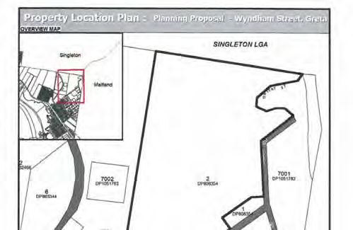
The site subject of this SEE is known as Lot 2 in Deposited Plan (DP) 1151267 and Lot 2 in Deposited Plan (DP)
808354. A locality plan showing the site and surrounding lands is provided in Figure 1.
The development involves subdivision to create two hundred and forty eight (248) allotments, two drainage
reserves, one allotment for open space, as well as earthworks and infrastructure works associated with each
stage of the development.
1.1 Site Context
Greta is located in the Cessnock Local Government Area (LGA). The West and Wyndham Streets Greta Urban
Release Area is located in the suburb of Greta and contains approximately 28.5ha of Low Density Residential,
8.51 hectares of Large Lot Residential Land and 7.7ha of Environmental Conservation land.
The site is surrounded by Large Lot Residential land to the south-east, rural land to the north and east and
residential land to the south-west. The Hunter River Regional Reserve is located to the north east of the site.
The desired future character of the West Street, Greta Urban Release Area is a mix of residential lot sizes that
reflect the constraints and opportunities of the site and complement the existing settlement pattern. On the
eastern side of the release area, minimum lot sizes will be 2,000m². On the western side of the release area,
there will be a mix of lot sizes ranging from 600m² to 2,000m².
The development area of the site is gently undulating topography with elevations on the site rising from RL 62
metres on the southern boundary to a maximum height of RL108 metres towards the northern boundary.
The land was the subject of extensive rezoning investigations. At the Cessnock City Council meeting on 19th
February 2014 the Planning Proposal to rezone the site was supported to make the amendment to the Cessnock
Local Environmental Plan 2011 pursuant to the Environmental Planning and Assessment Act.
Figure 1 Locality Plan
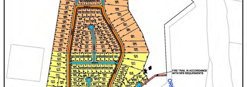
Wyndham Ridge Estate, Residential Subdivision – Statement of Environmental Effects

2.0 Proposal
The proposal subject of this SEE involves the subdivision of the site to create two hundred and forty eight (248)
allotments, two drainage reserves, one allotment for open space, as well as earthworks and infrastructure works
associated with each stage of the development.

A Concept Plan of Subdivision is illustrated in Figure 2 and Annexure 1.
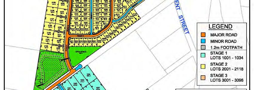
Wyndham Ridge Estate, Residential Subdivision – Statement of Environmental Effects

The lot layout/staging plan illustrate:

Two hundred and forty eight (248) proposed residential allotments of variable size.

The lots shown in stage 1 are located on the part of the site that is zoned R5 Large Lot Residential and in
accordance with the provisions of the CLEP 2011 the minimum lot size is 2,000m2.

The lots shown in stages 2 & 3 are located on the part of the site that is zoned R2 Low Density Residential. In
accordance with the provisions of the CLEP 2011 there is a mixture of minimum lot sizes of 600m2, 1,200m2 and
2,000m2.

Two drainage allotments are provided and dedicated to Council. One in the south west corner and the other in
the north west corner of the R2 Low Density Residential zone.

One proposed open space lot to be dedicated to Council in the south west portion of the R2 Low Density
Residential zone.

The proposal includes clearing of all vegetation (if necessary) contained within the area where the 248 residential
allotments, roads and associated services will be located. The proposal also includes earthworks and
infrastructure works necessary for the development of the land.

The constructed roads, drainage allotments and open space lot will be dedicated to Council.

2.1 Staging
The subdivision is to be constructed in three stages as illustrated in Figure 2 and Appendix 1.

Stage 1 involves the creation of 34 lots, the construction of West Street, construction of the south western
detention basin and associated infrastructure.

Stage 2 involves the creation of 118 lots and associated infrastructure.

Stage 3 involves the creation of 96 lots, construction of the north western detention basin and associated
infrastructure. Timing of the release of stages will be subject to market demand.

3.0 Consultations
A pre-DA meeting was held with Council staff on 7th March 2014. Minutes of this meeting are contained in
Appendix 2.

The SEE and DA has considered items outlined in the pre-DA meeting.

Post the pre-DA meeting further correspondence between the proponent and Council resulted in the final road
and pavements widths as adopted and shown in the SEE.
Wyndham Ridge Estate, Residential Subdivision – Statement of Environmental Effects

4.0 Planning and Statutory Considerations
4.1 Lower Hunter Regional Strategy
The LHRS 2006 provides a regional context to the need for accommodation population growth within the Lower
Hunter Region. The strategy discusses opportunities for urban release areas, infill development, centres and
corridors, and employment generating lands. The LHRS 2006 (p. 27) identifies that between 2006 and 2031 the
Maitland LGA is projected to accommodate an additional 26,500 dwellings. It is anticipated that the majority of
dwellings (21,500) will be contained within new urban release areas, while centres (2,000) and urban infill (3,000)
development will comprise the remaining 5,000 dwellings.

The LHRS identifies the subject site as a proposed urban area.

Following extensive investigations, the subject site has been incorporated into Cessnock Council’s City Wide
Settlement Strategy. Cessnock City Council at its meeting on 19th February 2014 resolved to forward a site
specific Planning Proposal to the Department of Planning and Infrastructure so that the site can rezoned as an
amendment to the Cessnock Local Environmental Plan 2011.

The proposed development described in this application is consistent with the LHRS as it contributes towards
meeting the demands for the supply of residential housing within the Lower Hunter.

4.2 Cessnock City Wide Settlement Strategy
The City Wide Settlement Strategy (CWSS) was adopted by Council on 15 September 2010. The CWSS sets out
strategic directions that informed the preparation of the CLEP 2011 and implemented a number of the outcomes
and actions arising from the LHRS. A fundamental action from the CWSS is the need to contain the urban
footprint of the Cessnock LGA to that identified in the LHRS and the CWSS.

The DA and SEE demonstrates the consistency of the proposed development of the site to the CWSS and CLEP
2011. The proposal for subdivision will be consistent with the objectives of the CWSS.

4.3 Environmental Planning & Assessment Act 1979
Section 79C Evaluation -Potential Matters for Consideration

In determining a development application, a consent authority is to take into consideration such of the following
matters as are of relevance to the development the subject of the development application:

(a) the provisions of:

   i.    any environmental planning instrument, and
  ii.    any proposed instrument that is or has been the subject of public consultation under this Act and that has
         been notified to the consent authority (unless the Director-General has notified the consent authority that
         the making of the proposed instrument has been deferred indefinitely or has not been approved), and
  iii.   any development control plan, and
 iv.     any planning agreement that has been entered into under section 93F, or any draft planning agreement
         that a developer has offered to enter into under section 93F, and
  v.     the regulations (to the extent that they prescribe matters for the purposes of this paragraph), and
 vi.     any coastal zone management plan (within the meaning of the Coastal Protection Act 1979), that apply to
         the land to which the development application relates,

(b) the likely impacts of that development, including environmental impacts on both the natural and built
environments, and social and economic impacts in the locality,
(c) the suitability of the site for the development,
(d) any submissions made in accordance with this Act or the regulations,
(e) the public interest.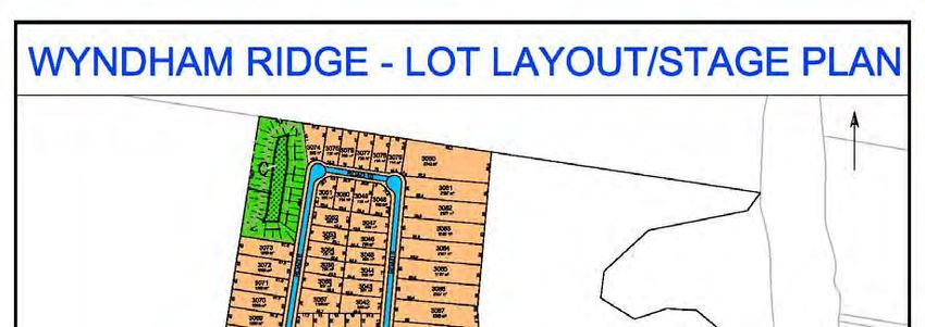
Wyndham Ridge Estate, Residential Subdivision – Statement of Environmental Effects
Section 91 Integrated Development

Integrated development is development which, as well as development consent, requires one or more approvals
under certain sections of the following State legislation:

This development is considered to be an integrated development due to the subject site being partly located
within a bushfire prone area. The DA will be referred to the Rural Fire Service by Council. A Bushfire Threat
Assessment has been undertaken and is discussed in Section 5.7 of this SEE.

The development will also be integrated development under the Water Management Act 2000, with respect to
the 2 bridge crossings within West Street.

4.4 State Environmental Planning Policy (SEPP)
State Environmental Planning Policy No. 44 – Koala Habitat Protection

The policy aims to encourage the conservation and management of areas of natural vegetation that provide
habitat for Koalas. Koalas are classified as “vulnerable and rare” species under the provisions of the Threatened
Species Conservation Act 1997.

The ecological assessment prepared for the site identified that the land does not constitute ‘Potential Koala
Habitat’ under the provisions of the SEPP. In addition, there were no sightings of Koalas utilising the site during
the ecological surveys. No further provisions of this Policy apply to the proposed development in this instance.

State Environmental Planning Policy No. 55 – Remediation of Land

The objective of SEPP 55 – Remediation of Land is to promote the remediation of contaminated land for the
purpose of reducing risk of harm to human health or any other aspect of the environment.

Clause 7 of the SEPP relates to development applications. That is, a consent authority must firstly consider
whether a site is contaminated. If the land is contaminated, the consent authority must be satisfied that the land
is suitable in its contaminated state, or it will be suitable after remediation, for the proposed development.

A phase 2 Contamination Assessment was undertaken in conjunction with the Planning Proposal for the subject
site. The assessment confirmed the subject site as being suitable for residential purposes.

State Environmental Planning Policy Infrastructure 2007 (ISEPP)

The following ISEPP provisions have been considered in relation to the proposal:

Clause 104 relates to traffic generation development. A traffic assessment has been prepared and is further
discussed within section 5.5 – Traffic and Access. The development will be referred to the Roads and Maritime
Services (RMS).

4.5 Cessnock Local Environmental Plan 2011
CLEP 2011 aims to make local environmental planning provisions for land in Cessnock in accordance with the
relevant standard environmental planning instrument under section 33A of the EP&A Act. The proposed
development is consistent with the Aims of the Plan under Section 1.2 of the CLEP 2011 which secures the
environmental, social and economic balance for the future of the LGA. The following provides commentary on the
relevant Parts within CLEP 2011.

Cessnock City Council at its meeting on 19th February 2014 resolved to forward a site specific Planning
Proposal to the Department of Planning and Infrastructure so that the site can rezoned as an amendment to the
Cessnock Local Environmental Plan 2011.
Wyndham Ridge Estate, Residential Subdivision – Statement of Environmental Effects
Part 2 ‐Land Use Zones
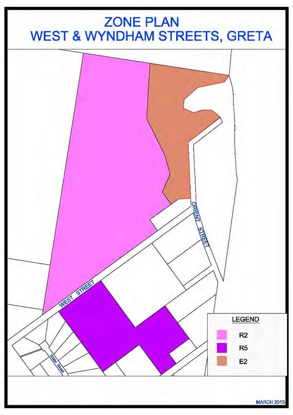
Figure 3 shows the zones adopted by Council of the site. The objectives of the relevant zones are as follows:
Zone R2 Low Density Residential
To provide for the housing needs of the community within a low density residential environment.
To enable other land uses that provide facilities or services to meet the day to day needs of residents.
Zone R5 Large Lot Residential
To provide residential housing in a rural setting while preserving, and minimising impacts on,
environmentally sensitive locations and scenic quality.
To ensure that large residential lots do not hinder the proper and orderly development of urban areas in
the future.
To ensure that development in the area does not unreasonably increase the demand for public services
or public facilities.
To minimise conflict between land uses within this zone and land uses within adjoining zones.
The proposed subdivision fulfils the objectives of both the R2 & R5 zones. The subdivision layout is adequately
sized and positioned to allow development of varying lot sizes within the relevant zone. The subdivision will
provide additional housing opportunities for both the local community and the wider region.
Supporting services and infrastructure will be provided throughout the development.
Figure 3 Zone PlanWyndham Ridge Estate, Residential Subdivision – Statement of Environmental Effects
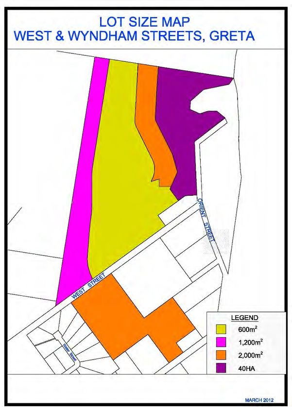
Part 4 ‐Principal development standards
4.1 Minimum subdivision lot size
The proposed subdivision has minimum lot sizes that are consistent with Section 4.1 of CLEP 2011.
Figure 4 shows the minimum lot size map adopted by Council. There is a mixture of minimum lot sizes of
600m2, 1,200m2 and 2,000m2. Lot sizes across the site ranges from 600m2 to 3,094m2. The subdivision provides
a range of varying lots sizes.
The location of the proposed lot boundaries are generally consistent with the concept development plan
considered by Council throughout the rezoning process.
Figure 4 Minimum Lot Size PlanWyndham Ridge Estate, Residential Subdivision – Statement of Environmental Effects Part 5 Miscellaneous Provisions 5.9 Preservation of trees or vegetation Removal of vegetation on site requires the consent from the Council. This application seeks approval for the clearing of land as described in section 2.0 – Proposal. This matter is further discussed is section 5.2. Part 6 Urban release areas The subject site is classified as an Urban Release Area. In accordance with Part 6 of the CLEP 2011 “satisfactory arrangements” are to be made for the provision of designated State public infrastructure before the subdivision of land in an urban release area to satisfy needs that arise from development on the land. The landowner of the site has commenced discussions with the Department of Planning and Infrastructure (DoPI) in order to achieve the “satisfactory arrangements” under Part 6 of LEP 2011. Further information regarding the nature of the “satisfactory arrangements” will be forwarded to Council during the DA assessment process. 6.2 Public utility infrastructure Council is to be satisfied, prior to consent, that any public utility infrastructure that is essential for the proposed development is available, or that adequate arrangements have been made to make that infrastructure available when it is required. Consultation has been undertaken with Hunter Water Corporation in relation to the provision of reticulated water and sewer infrastructure to the development area. This matter is further addressed in the Servicing Strategy discussed within section 5.13. Electricity supply and telecommunications will be provided to the development in accordance with the requirements of the relevant service authorities as the development progresses. 6.3 Development Control Plan This clause requires that a Development Control Plan (DCP) is to be prepared prior to any development consent being granted for development on land within an urban release area. The matters to be addressed in the DCP are prescribed in the clause. The DCP requirements are addressed within the local development controls in section 4.6. Part 7 Additional local provisions 7.1 Acid Sulphate Soils The development site is not identified on Council’s Acid Sulphate Soil Map as being located on land potentially containing Acid Sulphate Soil’s. 7.2 Earthworks The development site will require earthworks associated with the subdivision of land including the construction of roads, storm water and utility infrastructure. 7.3 Flood Planning The development site is not affected by any 1:100 year flood events. 4.6 Cessnock Development Control Plan 2010 The CDCP 2010 identifies general controls across the LGA and specific controls in certain localities. Within the CDCP 2010 a number of sections will apply to the proposal, including: • Part C Chapter 2 Flora and Fauna Guidelines and Waste Management; • Part D Chapter 1 Subdivision Guidelines; and • Part F Urban Release Areas – West and Wyndham, Street Greta. The following tables provide an outline of the relevant objectives within CDCP 2010 and a response to these objectives based upon various aspects of the development.
Wyndham Ridge Estate, Residential Subdivision – Statement of Environmental Effects
Part C Chapter 2 of DCP 2010: Flora and Fauna Guidelines
                                                                              Response
This chapter provides technical guidelines on the survey requirements         The SEE includes contains a Flora and Fauna Assessment per Section 5.2. The
for the preparation of flora and fauna reports.                               assessment complies with the provision of C.2 of DCP2010 and discussions held
                                                                              with Council’s environmental officer.

Part C Chapter 2 of DCP 2010: Waste Management
                                                                            Response
This chapter requires a waste management plan to be prepared.               The SEE includes a Waste Management Plan as contained in Appendix 11 and is
                                                                            discussed in Section 5.12 of this SEE.

Part D Chapter 1 of DCP 2010: Subdivision Guidelines
1.7 Specific Requirement for R2 Residential Subdivision
Element                             Prescriptive Measures                                                                                 Response
                                    a) The minimum lot size is the minimum area shown on the Lot Size Map, as per CLEP,                   Complies
                                    Clause 4.1 – Minimum subdivision lot size.

                                       b) Allotments shall have a minimum width of 18 metres at the building line.                        Complies

                                       c) An allotment shall not be less than 20 metres in depth to ensure there is some flexibility      Complies
                                       in the choice of housing design and siting, as well as the availability of suitable space for
1.7.1 Element 1: Lot size and shape    other activities normally associated with a dwelling-house.

                                       d) The dimensions for access ways (handles) for battle-axe shaped allotments are as                Complies
                                       follows: Maximum Length 60 metres
                                       Minimum Width 3.5 metres
                                       Minimum width of shared 5.0 metres

                                       e) No more than 5 allotments shall be served by an accessway.                                      Complies

                                       f) Vegetation which adds significantly to the visual amenity of a locality and / or which is       Complies
                                       environmentally significant or of habitat value shall be conserved in the design of the
                                       subdivision proposal.

                                       g) Lots shall be designed to allow the construction of a dwelling-house with a maximum cut         Complies
                                       or fill of 1.0 metre from the natural ground level (i.e. the dwelling house shall be designed to
                                       conform to the existing topography).
1.7.2 Accessway (handle) Design        a) Access ways (handles) shall have a minimum sealed width of 3.0 metres.                          Complies

                                       b) Access ways (handles) shall not serve more than 5 lots.                                         Complies
Wyndham Ridge Estate, Residential Subdivision – Statement of Environmental Effects
c) Access ways (handles) shall have a maximum grade of 25% (1:4) at any point Complies
d) The following standards apply to lots with battle-axe handles: Complies
Allotments Min width of battle-axe handle (metres)
1 3.5
2 5.0
3-5 2.0 per lot
e) Access ways (handles) shall be sited away from noise and visually sensitive components Complies
of existing and future dwelling houses.
f) Where possible, access ways (handles) shall be located on the south side of existing and Complies
future dwelling houses.
g) Access ways (handles) shall provide interest and variety and avoid lengthy straight Complies
sections.
h) Where the site is steep or fronts a local collector or higher order road (greater than 3,000 N/A
vehicles per day) or a highly pedestrianised area, accessways (handles) shall be designed
so that vehicles can be driven both onto and off the property in a forward direction.
i) Where vehicles would otherwise have to reverse more than 50 metres, a turning area N/A
shall be provided to enable the vehicles to enter and leave the site in a forward direction
and reduce the need to reverse over long distances.
1.7.3 Heritage a) See CLEP, Clause 5.10 – Heritage conservation. Complies
b) A subdivision proposal on land which contains, or is adjacent to, an item listed in CLEP, N/A
Schedule 5: Environmental heritage, shall illustrate the means proposed to preserve and
protect such items. In this respect a conservation plan, detailing how the item would be
restored, shall accompany the application.Wyndham Ridge Estate, Residential Subdivision – Statement of Environmental Effects
1.7.4 Local Street Design a) Design specifications for streets shall be as follows:
Allotments Road reserve Minimum Parking Kerb Type Complies, refer to section
widths (metres) carriage way Provision 5.5 of the SEE.
width (metres)
400 20.0 13.0 Carriage way Upright
* May be reduced to a minimum of 10 metres where access is required on only 1 side of the
road
1. Cul-de-sacs shall not exceed 200 metres in length unless topographic constraints render
other options impracticable.
2. Streets shall be designed to provide interest and variety in the streetscape through kerbs
(where appropriate), landscaping and paving treatments. The street design shall be
compatible with the existing road pattern in the locality.
3. No more than 3 turning movements at intersections shall be required in order to travel
from any home to the most convenient collector street or higher order road.
4. The minimum spacing of staggered junctions in a local street network shall be 20 metres.
5. Any subdivision proposal adjoining a rear lane shall be designed so as to provide both
vehicular and pedestrian access to the front street. Conversely, Council will not require the
upgrading of rear lanes where vehicular and pedestrian access has been provided to the
front street.
6. Cul-de-sacs for residential roads shall have minimum seal radii of 8.5 metres and
boundary radii of 12 metres.
1.7.5 Pedestrian and Cyclists a) No footpaths are required on streets with a traffic volume less than 300 vehicles per day Footpath locations have
as pedestrians can share the road surface with vehicles in a low speed environment. been discussed and
finalised with Council and
b) Footpaths shall be provided on one side of streets with traffic volumes between 300 are as shown on the DCP
vehicles per day and 2,000 vehicles per day and on both side of streets with traffic volumes indicative lot layout plan
over 2,000 vehicles per day.
1.7.6 Solar Access and Lot a) See Schedule 2 – Solar Access and Energy Efficiency. 80% of lots will have 5
Orientation star access
1.7.7 Stormwater Management a) Where site topography prevents discharge of storm water directly to the street gutter or a Refer to Stormwater
Council controlled pipe system, inter-allotment drainage shall be provided to accept runoff Strategy section 5.3 of the
from existing or future impervious areas on the subject land. The design and construction of SEE and Appendix 4.
the inter-allotment drainage system shall be in accordance with the requirements of
‘Australian Rainfall and Runoff (1987)’.Wyndham Ridge Estate, Residential Subdivision – Statement of Environmental Effects
b) Storm water shall drain by gravity to Council's system which may require inter-allotment
drainage. Easements having a minimum width of 2.0 metres are to be identified on
submitted plans.
c) Proposals may require the creation of easements over downstream properties for
drainage purposes. In this circumstance, a letter of consent from the owner/s of the
downstream properties shall be submitted with the Development Application.
d) For subdivision proposals comprising 5 lots or more or where Council deems it
necessary, a soil and water management plan (SWMP) shall be prepared by a suitably
qualified professional with the aim of minimising erosion and maximising the quality of any
water leaving the site. The contents of a SWMP should be modelled on the information in
Schedule 1.
1.7.8 Utility Services a) Provision of written evidence of compliance with the requirements of all relevant service Complies
authorities prior to release of construction certificate or subdivision certificate, as may be
appropriate.
b) Underground power to be provided to all lots.
Part D Chapter 1 of DCP 2010: Subdivision Guidelines
1.6 Specific Requirement for R5 Large Lot Residential Subdivision
Element Prescriptive Measures Response
a) The minimum lot size is the minimum area shown on the Lot Size Map, as per CLEP, Complies with minimum
Clause 4.1 – Minimum subdivision lot size. 2,000m2 lot size
b) Lots shall accommodate a suitable building envelope with a minimum dimension of 20 Complies
metres. Building envelopes shall be located a minimum of 4.0 metres from significant trees
and other significant vegetation or landscape features. Building envelopes shall include the
area for the siting of a dwelling-house, outbuildings, landscaping and on-site effluent
1.6.1 Element 1: Lot size and shape treatment and disposal areas (if required and permitted).
c) The design of the subdivision shall take into account any significant natural features on Complies
the site and these shall be retained.
d) Vegetation which adds to the visual amenity of the locality and / or which is Complies
environmentally significant shall be preserved in the design of the subdivision proposal.
e) The width to depth ratio of allotments shall not exceed 1:4. If lots are too elongated, land Complies
uses may be restricted (e.g. the shape of long lots may preclude the establishment of
dams).Wyndham Ridge Estate, Residential Subdivision – Statement of Environmental Effects
1.6.2 Agriculture a) Compliance with Part C: General Guidelines, Chapter 4: Land Use Conflict & Buffer Complies. Refer to
Zones. section 5.11 of the SEE
for odour assessment.
b) Subdivision of land that is classified as ‘prime agricultural land’ (classes 1, 2 or 3) may Complies – land is not
require referral to and comment from NSW Industry and Investment (Agriculture). Any prime prime agricultural land
agricultural land occurring on the subject land is to be identified on the plans submitted.
c) Subdivision proposals are not to negatively impact upon sustainable agricultural Complies – land is zoned
activities. R5 for proposed
development
1.6.3 Effluent Disposal a) An effluent disposal / geotechnical report may be required depending upon site N/A – All lots will have
requirements and constraints. Some assessment of the proposed lots will be required to be reticulated sewer in
submitted with the application to identify basic site constraints and identify any areas accordance with Hunter
considered suitable for effluent disposal. The NSW State Government’s ‘Environmental & Water Corporations
Health Protection Guidelines – On-site Sewage Management for Single Households’ requirements.
(February 1998) should be used as a guide to this assessment.
b) Council may require submission of a geotechnical investigation report in certain cases, N/A
depending upon soil conditions, and number of lots proposed, size of allotments and the
like.
c) Disposal of effluent shall not create a health nuisance or pollution particularly in relation N/A
to nutrients infiltrating into bushland and / or watercourses.
d) Where reticulated sewer is not available, effluent will be contained, treated and disposed N/A
of totally on the subject site. The disposal of effluent utilising pump-outs for new lots is
unacceptable.
e) For subdivisions proposing to create 5 or more allotments of 2.0 hectares or below in N/A
size, or where any boundary of the proposed subdivision is within 2.0 kilometres of an
existing sewage reticulation system, Council may require the provision of a reticulated
sewerage treatment system. The only circumstances where this standard should be varied
is on sites already substantially cleared of native vegetation, where soils are highly suitable
for effluent disposal and where they are not located near a watercourse, wetland or other
environmentally sensitive area. In these cases, a detailed investigation into the disposal of
effluent on-site, including any long-term and / or cumulative effects will be required. Such
investigation shall be generally in accordance with the requirements of the NSW State
Government’s ‘Environment & Health Protection Guidelines – On-site Sewage Management
for Single Households’ (February 1998).
f) Any disposal system within 40 metres of a watercourse is ‘Integrated Development’ under N/A
the provisions of the Environmental Planning & Assessment Act 1979.Wyndham Ridge Estate, Residential Subdivision – Statement of Environmental Effects
1.6.4 Flora and Fauna a) See Part C: General Guidelines, Chapter 2: Flora and Fauna Survey Guidelines. Addressed in section 5.2
of SEE
b) Under-scrubbing is not to be undertaken without consent from Council.
c) Degraded areas are to be rehabilitated as part of the subdivision.
d) Watercourses and drainage lines to be retained as part of the subdivision scheme are to
be stabilised and revegetated with appropriate native species.
e) Environmentally sensitive areas are to be preserved and enhanced with appropriate
native vegetation where necessary.
1.6.5 Hazards a) Where a subdivision proposal is located on bushfire prone land the applicant shall Address in section 5.7 of
comply with the NSW Rural Fire Services' document ‘Planning for Bushfire Protection 2006’ the SEE.
and Council’s Bushfire Management Plan. In general, Council will not favourably consider
subdivision of heavily vegetated land in bushfire prone areas where the subdivision will
require subsequent clearing of vegetation to meet required radiation zones, access
requirements and the like.
b) In accordance with the requirements of the abovementioned documents, details shall be Addressed in section 5.7
provided regarding the dimensions of the fire protection zone and arrangements and of the SEE.
maintenance for access for bushfire fighting vehicles. Two separate points of access may
be required in some circumstances.
c) Where a subdivision proposal is on land identified as being potentially subject to landslip, Land is not subject to
the applicant shall engage a geotechnical consultant to prepare a report on the viability of landslip.
subdividing the land and if viable, provide recommendations as to the siting and the type of
buildings and waste water treatment systems which could be permitted on the subject land.
Land is not contaminated,
addressed in section 5.9
d) Compliance with Part C: General Guidelines, Chapter 3: Contaminated Lands.
of the SEE
1.6.6 Heritage a) See CLEP, Clause 5.10 – Heritage conservation. Complies. No items are
identified on the subject
b) A subdivision proposal on land which contains, or is adjacent to, an item listed in CLEP, site in CLEP.
Schedule 5: Environmental Heritage, shall illustrate the means proposed to preserve and
protect such items. In this respect a conservation plan, detailing how the item would be
restored, shall accompany the application.
1.6.7 Roads and Access a) See Council’s ‘Engineering Requirements for Development’. Complies, address in
section 5.5 of the SEE.
b) Design details may be required during development application assessment. Complies, address in
section 5.5 of the SEE.
c) A maximum of two rural lots may gain access from a ‘right of carriageway’. N/AWyndham Ridge Estate, Residential Subdivision – Statement of Environmental Effects
1.6.8 Soil and Water Management a) Depending upon the scale, location and nature of the subdivision proposal, a Soil and Erosion and sediment
Water Management Plan (SWMP) may be required to be prepared by suitably qualified control plans will be
persons. This is most likely where any construction works are required as part of the provided with
subdivision. Early consultation with Council officers will confirm whether a SWMP is Construction drawings.
required. The plan shall detail best management practices in regard to soil conservation and
pollution control measures to be installed prior to clearing and earthworks and maintained
until revegetation measures are complete. The contents of a SWMP are shown in Schedule
1.
b) In subdivision proposals where clearing is minimal and earthworks are limited a SWMP
may not be required. Compliance with Council’s ’Engineering Standards for Development’
will be required.
1.6.9 Stormwater Management and a) See Council’s ‘Engineering Requirements for Development’. Complies, addressed in
Drainage section 5.3 of the SEE.
1.6.10 Utility Services a) Adequate water supplies for both domestic and firefighting purposes must be available. Complies, lots will be
connected to HWC
reticulated mains.
b) Electricity shall be provided to all lots, except for those considered by Council to be Complies, lots will be
‘remote’, where the requirement may be waived and a covenant placed on the title of the connected to the
land where possible. electricity network.
1.6.11 Visual Amenity a) Building envelopes, accessways and roads shall avoid ridge tops and steep slopes. Complies. The
subdivision layout is in
b) Subdivision of escarpments, ridges, and other visually interesting places shall be accordance with the site
managed in such a way that the visual impact rising from development on newly created specific DCP.
allotments is minimal.
c) Subdivisions shall be designed so that, when subsequently developed, visually significant The land is not identified
vegetation, such as that found on ridge tops and other visually prominent locations will be as visually sensitive.
retained.
d) Proposals to subdivide visually sensitive or prominent areas will require the submission
of a visual impact assessment report.Wyndham Ridge Estate, Residential Subdivision – Statement of Environmental Effects
Part F – Urban Release Areas, West and Wyndham Streets Development Control Plan
Element Prescriptive Measures Response
1. Staging Plan All development applications for subdivisions shall include a staging plan, where the Complies. Staging Plan
development is intended to be released sequentially. The development is to be staged from provided in Figure 2 in the
South to North in accordance with the Indicative Layout Plan shown in Figure 1 of the DCP. SEE
Prior to any subdivision of the site, West Street must be constructed to the satisfaction of
Council.
2. Transport Movement Hierarchy The road layout must be consistent with the Indicative Layout Plan shown in Figure 1 of the Complies
DCP. Development applications for subdivisions must ensure that road networks connect to
other development areas in a logical manner.
The extension of West Street through to the Urban Release Area is to be constructed in Complies. Stormwater
accordance with Council’s engineering guidelines. contribution funding is
addressed in the Planning
Agreement Contributions.
No access to Wyndham Street is to be provided until Stage 1 is finalised.
There must be no direct access to Wyndham Street either via an intersection, road or Complies, road dedication
driveway access from new residential allotments. However, provisions shall be made for per Council discussions.
future access to connect the when the balance of the Greta Investigation Area is developed.
An off road cycle way / footpath is to be constructed on the eastern side of West Street from Complies. These works
High Street to the main road entry of the Urban Release Area (approximately 1000m). All are funded in the
road, footpath/cycleway works must be completed in accordance with Council’s standards. Planning Agreement
Contributions
The transport movement hierarchy shall generally be in accordance with the circulation Complies
route shown on the Indicative Layout Plan (Figure 1). Suitable transport access and
connectivity within the site and to adjoining areas shall be maintained at all times for motor
vehicles, pedestrians and cyclists.
3. Overall Landscape Strategy A landscape plan must be submitted with development applications for subdivision. Any Addressed in section 5.8
future landscaping should aim to utilise locally occurring species. The subdivision design is of the SEE
to provide for lot frontages addressing streets, and drainage reserves.
Residential boundary fencing must comprise consistent materials and colour. Boundary Complies
fencing in and adjoining the R5 - Large Lot Residential zone must have an open style rural
character. This may include post and rail/wire fencing.
4. Passive and Recreational Areas The Indicative Layout Plan identifies areas of passive and active recreational spaces. These works are funded
Embellishment of passive and active open spaces are to be undertaken in accordance with in the Planning
Councils Recreation and Open Space Strategic Plan (2009). Agreement ContributionsWyndham Ridge Estate, Residential Subdivision – Statement of Environmental Effects
5. Stormwater and Water Quality The Indicative Layout Plan identifies details of stormwater management facilities. Adequate Addressed in section 5.3
Management Controls stormwater management must be provided at all times during the staged release of land. of the SEE
Stormwater management facilities are to include appropriate landscaping and are to be
designed to Councils standards.
All development applications are required to demonstrate that there will be no detrimental
impact on downstream waterways, wetland environments or agricultural productivity as a
result of new development. Details are to be submitted with the development applications or
at each stage for the subdivision.
6. Amelioration of Natural and Bushfire - Future development must be assessed in accordance with the NSW Rural Fire Complies – addressed in
Environmental Hazards Service’s ‘Planning for Bushfire Protection Guidelines’ 2006 and provide Asset Protection section 5.7 of the SEE.
Zones (APZs) configured in accordance with the Guidelines.
Flora & Fauna
Any proposed tree removal shall be in accordance with Part C: General Guidelines Chapter Complies
7 Trees & Vegetation Management of the Cessnock DCP.
Riparian Corridors - A Vegetation Management Plan (VMP) must be submitted with any Complies – addressed in
future development application to subdivide the land, that impacts on a riparian corridor. section 5.2 & 5.4 of the
SEE.
The VMP shall identify a strategy to appropriately manage the natural watercourse and
riparian vegetation. Appropriate measures shall include:
the implementation of a core riparian zone and vegetated buffer combined into a single
vegetated riparian zone (VRZ) in accordance with the Department of Primary Industries –
Office of Water Guidelines for riparian corridors on waterfront land;
a restriction on vegetation removal within the VRZ.
no buildings other than posts & rails are permitted within the VRZ.
Poultry Farm - The proposed subdivision is located within 1,200m of an operating poultry Complies – addressed in
farm to the west as well as a nearby meat chicken farm that is likely to have cumulative section 5.11 of the SEE.
odour impacts. Prior to subdividing any of the land, a Level 1 Odour Assessment must be
prepared and submitted in accordance with the “EPA Technical Framework – Assessment
and Management of Odour from Stationary Sources in NSW”.
The Level 1 Odour Assessment shall be referred to the NSW Department of Primary
Industries for comment prior to obtaining development consent to subdivide the land. Any
recommendation and/or actions contained within the Odour Assessment respect must be
complied with prior to the release of the Construction Certificate and / or any stage of the
subdivision.Wyndham Ridge Estate, Residential Subdivision – Statement of Environmental Effects
7. Significant Development Sites Development within residential zones must be designed and planned to ensure any Asset Complies
Protection Zones are not located within the E2 Environmental Protection zone.
Development or works within, or adjacent to the land zoned E2 Environmental Protection Complies
are to ensure clearing of vegetation is minimised.
Mechanisms are to be put in place with development to ensure the integrity and protection Complies, a VMP is to be
of established vegetation and riparian areas zoned E2 Environmental Protection. Details are registered on title via a
to be included in all Development Applications affecting the E2 zone. separate development
application with Council
Fencing is to make a positive contribution to the visual appearance of development. Complies, existing post
Fencing adjacent to the boundaries of the surrounding rural lands and visually sensitive and wire fence
areas shown on the Indicative Layout Plan shall be unobtrusive, compatible with the rural
character, and may include timber post and rail style. Fencing details is to be submitted to
Council with development applications.
Development adjacent to rural zones lands are to be suitably designed so as to be Complies
compatible with the existing rural landscape and setting.
8. Residential Densities The Urban Release Area due to its location at the extremity of the existing Greta area is Noted
largely proposed as a low density precinct. Any dual occupancy, medium density or
integrated housing developments are to be designed around areas of high amenity, being
sites adjacent to open space, water bodies and bus routes and be capable of providing
private open space.
9. Neighbourhood Commercial and There are no specific requirements in this regard. N/A
Retail Use
10. Provision of Public Facilities and There are no specific requirements in this regard. N/A
Services
11. Sewer and Water Reticulation Sewer and water reticulation must be provided in accordance with the requirements of the Complies – servicing
Hunter Water Corporation. A water supply servicing strategy is to be prepared at the strategies have been
development application stage to address augmentation requirements for servicing lots undertaken with HWC.
above RL90m.
12. Voluntary Planning Agreement Any future development must have regard for the Voluntary Planning Agreements applying Complies
to the land:
Local Infrastructure - Voluntary Planning Agreement Adopted by Council for Public
exhibition dated 19 February 2014; and
On-site and Off-site Biodiversity Offsets - Voluntary Planning Agreement adopted by
Council for Public exhibition dated 18 June 2014Wyndham Ridge Estate, Residential Subdivision – Statement of Environmental Effects 5.0 Planning and Design 5.1 Subdivision Design Considerations Urban Design Principles The proposed subdivision fulfils the principles of good design through a layout achieving connectivity while responding to site constraints and opportunities. The Concept Plan of Subdivision is shown in Figure 2 and Annexure 1 demonstrates the subdivision being designed to create a safe subdivision. The layout is generally consistent with the plan of subdivision that was considered by Council in conjunction with the rezoning of the lands, and was used to inform the zone boundaries and minimum lot size boundaries for the site. The layout is in accordance with the site specific Development Control Plan. Lot Size and Dimensions The proposed subdivision provides a varied lot range, in terms of type and size. The development will consist of allotments with lot sizes ranging between 600m2 to 3,094m2 in size. Allotments generally front relatively straight sections of proposed streets and are regular shaped with similar primary street frontage to rear boundary ratios. All allotments have been designed to provide sufficient access to services, solar access, sitting of buildings, access to the each allotment within the constraints of the site. Solar Access & Energy Efficiency The internal road network within the proposed subdivision is orientated primarily in either a north-south or east- west direction. The orientation of the street determines the amount of solar access received. A combination of aspect and orientation will determine the solar access for each allotment. The allotments have an area to suitably site a building envelope with sufficient solar access. Crime Prevention through Environmental Design Effective designs of subdivisions can reduce community fear, as well as opportunities for crime. The proposed subdivision complies with the principles of CPTED and best practice guidelines with design details as described in the following sub-sections. Pedestrian and Cycle Routes The subdivision does not create opportunities for crime risk or community fear by providing places for offenders to hide or entrap victims. Pathways will link to the open space areas and off road cycleways that link the development to the town of Greta creating and open feel. Similarly, opportunities for natural surveillance are afforded from nearby residences and from vehicles using the road network. Natural Surveillance The objectives of natural surveillance are to encourage the passive observation of spaces from surrounding buildings and land uses and to further improve surveillance through increased legitimate use. To ensure that the objectives of natural surveillance are met, clear sightlines have been provided between public (streets and pathways) and private spaces. At the construction stage of the residential subdivision, natural surveillance should be reinforced by focusing on orientation of buildings and strategic use of windows, balconies, entrances, permeable fencing and street design. Landscaping A Landscape Concept Plan and Report for the proposed subdivision has been prepared by Moir Landscape Architecture and is contained in Appendix 9. The Landscape Concept Plan will ensure that the subdivision is attractive and encourages legitimate use of public spaces. Lighting Lighting of public places such as public streets and pedestrian areas will meet the relevant Australian Standards.
Wyndham Ridge Estate, Residential Subdivision – Statement of Environmental Effects
Solar Access and Energy Efficiency
The CDCP 2010 requires subdivisions to consider solar access in the design of lots. The lot orientation of the
subdivision will enable effective solar access and energy efficiency of future dwellings.
5.2 Ecology
The site has been the subject of a several ecological studies completed to support the rezoning of the land and
provision of a biodiversity offset package, including HSO (2006), EcoLogical Australia (2011), and Firebird
ecoSultants Pty Ltd (2013). A biodiversity offset package for the proposal has been implemented at the land
rezoning stage. In consultation with the NSW Office of Environment and Heritage (OEH) and Cessnock City
Council, a planning agreement under section 93F of the EP&A Act ensures the provision of biodiversity offsets to
compensate for the loss of biodiversity which will occur as a result of the proposed development.
The NSW Minister for the Environment has formally agreed to accept the 297 hectare off-site offset, being Lot 9,
Lot 102 and Lot 207 DP753817 for addition into Wollemi National Park and the provision of $26,000 to cover
reserve establishment costs. The on-site offset, being the 7.9 hectare E2 Environmental Conservation zoned
land, will be protected by a positive covenant under Section 88B of the Conveyancing Act 1919 and the land
managed for conservation purposes through a Vegetation Management Plan. It has been demonstrated that the
biodiversity offset package will ensure that regional biodiversity values are maintained and that it is acceptable to
meet OEH requirements to permit the whole of the proposed residential development and the inevitable clearing
of the site. The planning agreement and proposed offset contributions will protect areas containing like-for-like
habitat for Central Hunter Ironbark – Spotted Gum – Grey Box Forest EEC and threatened species impacted
upon by the proposed development.
The planning agreement legally establishes the manner and timing in which the biodiversity offsets will occur. It
will also achieve the protection of the biodiversity significance of land both on-site and off-site in perpetuity to
offset the potential impacts arising from the development.
Based on the survey effort and results of these previous studies, and in consultation with Cessnock Council
ecologist Firebird ecoSultants Pty Ltd undertook a report to recognise the relevant requirements of the
Environmental Planning and Assessment Act 1979 (EP&A Act) and the Threatened Species Conservation Act
1995 (TSC Act) by undertaking assessments of significance (7-part tests) to support a development application
for the residential subdivision and development. The report is contained in Appendix 3.
The report concluded the impact on the environment from the residential development is not significant and is
unlikely to place any viable local populations of threatened species at risk of extinction. The report
recommended the following recommendations:
The proposed planning agreement is enacted to facilitate the biodiversity offset package;
Construction and development activities are contained within the residential zoned areas;
The land zoned E2 Environmental Conservation is fenced;
Landscaping / habitat revegetation within the site to use local endemic species characteristic of the
endangered ecological communities present;
Hydrological controls (e.g. Water Sensitive Urban Design principles) are implemented to maintain the quality
and quantity of pre-development water flows into downstream areas;
Ecologist present during hollow-bearing/habitat tree removal.
5.3 Stormwater and water quality
Fisher Consulting Engineers has prepared a Stormwater Drainage Strategy for the proposed subdivision and is
contained in is contained in Appendix 4.
The stormwater drainage strategy addresses stormwater quantity and quality requirements, and flood levels for
the proposed development.
Stormwater Flow Management (stormwater runoff quantity and quality)
The strategy for management of stormwater runoff from the development as depicted in the report comprises:Wyndham Ridge Estate, Residential Subdivision – Statement of Environmental Effects
Capture of stormwater from lot and road reserve areas by a conventional pit and pipe drainage network
located in the street or in interallotment drainage easements where required.
Conveyance of captured stormwater within the drainage pipe network to gross pollutant traps (GPT’s) for
primary treatment prior to discharge into the proposed combined detention basin and constructed
wetland.
The detention basins will provide attenuation of developed stormwater flowrates to existing flowrate
conditions.
The constructed wetland will provide secondary/tertiary treatment and polishing of the stormwater runoff
prior to discharge downstream.
Discharge from the outlet of the constructed wetlands will be conveyed over land to the existing
unnamed watercourse.
The proposed stormwater management measures will be located within drainage reserves and dedicated to
Council consistent with other developments within the Cessnock LGA.
Flooding
In 2010 WMAwater engaged by Cessnock City Council and Maitland Council released a report titled the Hunter
River, Branxton to Green Rocks Flood Study, known as Flood Study 2010. The subject sites developments
footprint ranges from R.L 62m AHD to R.L 108m, and the 100 year (1% AEP) flood level is R.L 27m AHD.
Therefore the development is not affected by flooding from the Hunter River, and no further investigation was
considered necessary for the intent of the strategy.
5.4 NSW Office of Water Creek Crossings
Fisher Consulting Engineers has prepared a bridge crossing report of pre and post development hydraulic
conditions for two proposed bridges located in the existing unformed road reserve of West Street, downstream of
the proposed Wyndham Ridge subdivision. This report has been prepared to support a Controlled Activities
Approval application to the NSW Department of Water. The report is contained in is contained in Appendix 5.
5.5 Traffic and Access
SECA solution prepared a Traffic Impact Statement for the site and the Statement is contained in Appendix
6. The Statement considered traffic data collected in conjunction with field observations and obtained
background data from the Roads and Maritime Service (RMS) for the locality.
Overall the Statement concludes that the additional traffic movements generate by the development will have an
acceptable impact upon the local road network.
The Traffic Impact Statement for the site was reviewed by Cessnock City Council in conjunction with the Planning
Proposal and Voluntary Planning Agreement (VPA) Infrastructure Contributions. This review resulted in the
following external road works being included and funded in the Local Area Monetary Contributions for Traffic and
Drainage:
West Street – Reconstruction from High Street to Branxton Street, Widen & reconstruct road with kerb
and drainage;
Bus Bay – Water Street to entry driveway, Construct 1 indented bus stop with all-weather shelter
Bus Bays within proposed subdivision, 2 bus shelters
West Street – Shared off road footpath/cycleway, West Street from High Street to Branxton Street (200m)
and West Street from Branxton Street to entry driveway (800m)
West Street – Drainage lines
No other road or drainage work upgrades external to the sites boundaries are required.Wyndham Ridge Estate, Residential Subdivision – Statement of Environmental Effects
Proposed internal road reserve and pavement widths have been discussed and agreed with Council as shown in
the table below:
Road Number Road Reserve Width (metres) Pavement Width (metres)
1 Existing 11
2 20 11
3 18 11
4 15 6
5 15 6
6 15 6
7 15 6
8 15 6
9 15 6
10 15 6
11 18 8
12 15 6
5.6 West Street Engineering Report
Fisher Consulting Engineers prepared an Engineering Report for the proposed road works within the unformed
road reserve of West Street Greta, to support a proposed Development Application for a residential subdivision.
The Engineering Report addresses general engineering options in the unformed West Street road reserve that
are likely to be required to support the proposed residential subdivision. The report is contained in Appendix 7.
West and Branxton Street Intersection
The existing intersection of West Street and Branxton Street will require upgrading in conjunction with the
proposed extension of West Street to the proposed subdivision. The report shows a concept upgrade of the
intersection with a vehicle priority change giving main priority to vehicles travelling along West Street. It is
proposed that vehicles travelling on Branxton Street will have secondary priority. This arrangement is consistent
with other existing roads which are running parallel to West Street on its south eastern side.
West Street road layout
Council have advised that the unformed portion of West Street is to be constructed with an 11.0m wide kerb face
to kerb face carriageway. It is proposed to provide a 2.0m wide verge on the north western side (LHS) of the
11.0m wide road and a 4.5m wide verge on the south eastern side (RHS) of the 11.0m wide road. The 4.5m
wide verge is to contain a 2.0m wide combined pedestrian footpath and cycleway. It is considered that a narrow
footway adjacent to rural property, which is not the subject of this development application, is appropriate to
assist the constructed roadway’s batter extent to be maintained within the existing road reserve.
To assist in minimising the required works at the two watercourse crossing locations, it is proposed to narrow the
constructed roadway to 8.0m kerb face to kerb face, and to narrow the LHS and RHS verges. Narrowing of the
roadway and verges will assist in minimising the required crossing structures which will, in turn, assist in
minimising the impact on the watercourse’s existing environment. It is proposed to maintain the 8.0m roadway
formation between the two watercourse crossing locations to maintain consistency for vehicular movements
along West Street. It is considered that the narrowing of the pavement at the two watercourse crossing
locations, and for the roadway in between, to be appropriate as there should not be any permitted vehicular
parking in this vicinity, and cyclists are catered for via the proposed combined pedestrian footpath and cycleway.
Stormwater Conveyance in West Street
A traditional pit and pipe system is proposed for the carriageway within the unformed road reserve of West
Street. The pit and pipe system will capture and convey stormwater flows from the road carriageway and
discharge the flow into the existing watercourse.
It is proposed that two bridge structures will be constructed at the location of the two watercourse crossings to
convey the watercourse flow through the West Street road reserve. The bridge structures will generally enable
the existing features of the watercourse to be maintained.You can also read