Development Victoria 621 Burwood Highway, Knoxfield - Preliminary Stormwater Management Strategy
←
→
Page content transcription
If your browser does not render page correctly, please read the page content below

Development Victoria
621 Burwood Highway, Knoxfield
Preliminary Stormwater Management Strategy
February 2021

V6000_006-REP-001-11
Development Victoria
621 Burwood Highway, Knoxfield

Contents

1     INTRODUCTION                                                  1
2     STORMWATER QUANTITY MANAGEMENT                                3

2.1   MINOR DRAINAGE SYSTEM                                         4

2.2   MAJOR DRAINAGE SYSTEM                                         4

2.3   HYDROLOGIC MODELLING                                          4
3     STORMWATER QUALITY                                            6

3.1   WETLAND                                                       7

3.1.1 Inundation Frequency                                          8

3.1.2 Construction staging                                          9

3.2   HABITAT CREATION                                              9

3.3   ADDITIONAL BENEFITS OF WETLAND ASSETS                         9

3.3.1 Integration and public use                                    9

3.3.2 Integrated Water Cycle Management                             9
4     FLOOD MODELLING OF BLIND CREEK                                11

4.1   EXISTING CONDITIONS                                           11

4.2   DEVELOPED CONDITIONS                                          11
5     EXISTING DAM                                                  14

5.1   CURRENT CONDITION OF THE DAM                                  15

5.2   REMOVAL OF THE EXISTING DAM                                   15
6     STORMWATER MANAGEMENT PLAN                                    17
7     CONCLUSIONS AND RECOMMENDATIONS                               18
8     QUALIFICATIONS                                                19
9     REFERENCES                                                    20

Appendices
Appendix A: Hydrologic Calculations and RORB Model Parameters

Appendix B: Water Quality Calculations and MUSIC Model Parameters

Appendix C: Proposed Wetland Design Plans

Appendix D: Blind Creek RORB and Tuflow modelling

Appendix E: Flood Maps
Development Victoria
621 Burwood Highway, Knoxfield
List of Tables
Table 2-1: 1 % AEP Event Existing Conditions Scenario with Dam Results 5
Table 2-2: 1 % AEP Event Proposed Development Scenario with Wetland/Retarding Basin Results 5
Table 3-1: BPEMG Environmental Management Objectives for Stormwater (CSIRO, 1999) 6
Table 3-2: Treatment Train Effectiveness Development area only 6
Table 3-3: Treatment Train Effectiveness including external catchments 7
Table 4-1: Flood level comparison 11
Table 4-2: Floodplain storage in 1 % AEP 12
List of Figures
Figure 1-1: Knoxfield Development Locality Map 2
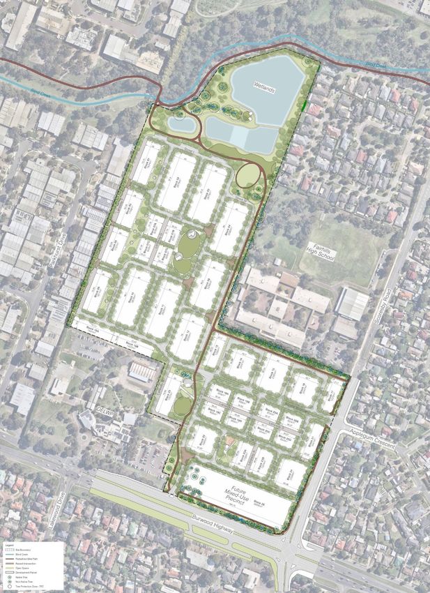
Figure 2-1: Proposed Knoxfield Development 3
Figure 3-1: Inundation Frequency analysis 8
Figure 4-1: Hydrograph from Tuflow modelling 360 m downstream of the development site 12
Figure 5-1: Topography and bathometry of the existing dam based on survey data 14
8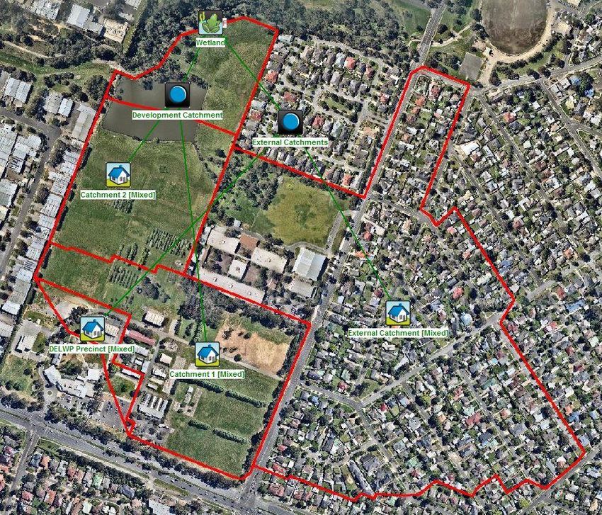
Development Victoria
621 Burwood Highway, Knoxfield
1 INTRODUCTION
Engeny Water Management (Engeny) was engaged by Development Victoria (previously Places Victoria) to review the current
onsite stormwater conditions and provide recommendations regarding the stormwater and drainage requirements of the future
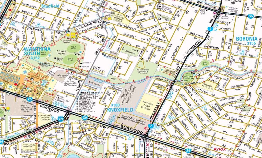
residential and mixed use development of the site at 621 Burwood Highway, Knoxfield. Figure 1-1 provides an overview of the
development location.
621 Burwood Highway, Knoxfield is the disused Institute of Horticultural Development site. Commercial and industrial properties
are located to the west and the DELWP Precinct is located to the site’s immediate south-west. The Fairhills High School and
residential properties lie to the east of the site.
The site is bounded to the north by the Blind Creek waterway. A large dam, spanning approximately 1.4 hectares is situated in
the site’s north-west corner and connects to the waterway corridor. Currently, this dam provides a water storage function, with
limited treatment. The dam was built for water supply for previous use of the site for agricultural purposes. Ecological studies of
the site (Ecocentric Environmental Consulting, 2015) have identified the presence of the endangered, Victorian Flora and Fauna
Guarantee Act 1988 (FFG Act) listed Blue Billed Duck within this dam. Given the sizeable portion of land currently occupied by
the dam and a number of significant existing problems with the dam, Engeny has considered future options for the dam as part
of this study.
This report proposes a stormwater management strategy for the site that will achieve multiple benefits for the existing community,
open space, the environment and future residents of the site. Aspects of the proposed layout in relation to water management
that are described in this report include:
• Improved habitat
• Improved open space
• Improved public access
• Integrated water management to reduce potable water demand, reduce wastewater discharges and reduce stormwater
discharges
• Improved integration of Blind Creek and it’s corridor with the site
• Improved stormwater quality (the layout includes provision of a system to treat stormwater runoff from the new development,
in accordance with the Urban Stormwater Best Practice Environmental Management Guidelines (BPEMG)).
This report was first prepared in 2017 but has been updated based on the revised design work by PGA, updated master planning
and to account for the update to Australian Rainfall and Runoff. The general concept for treatment is still largely unchanged.
1 V6000_006-REP-001-11 / February 2021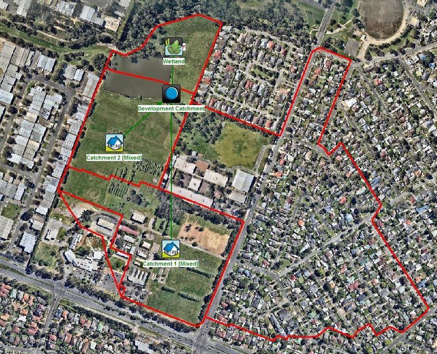
Development Victoria
621 Burwood Highway, Knoxfield

Figure 1-1: Knoxfield Development Locality Map

 2                                               V6000_006-REP-001-11 / February 2021
Development Victoria
621 Burwood Highway, Knoxfield

2         STORMWATER QUANTITY MANAGEMENT

The proposed development will comprise of medium density residential development mixed with open space reserves over most
of the site with a mixed use precinct at its southern end and an area for water treatment and habitat adjacent to Blind Creek as
shown in Figure 2-1.

Figure 2-1: Proposed Knoxfield Development

 3                                                                                             V6000_006-REP-001-11 / February 2021
Development Victoria
621 Burwood Highway, Knoxfield

2.1           MINOR DRAINAGE SYSTEM
The minor drainage system will consist of a subsurface pipe network designed to capture and convey all stormwater runoff
generated from the catchment for rainfall events up to and including the 10 % AEP (annual exceedance probability) design storm
(1 in 10 year ARI).

As the local catchment is less than 60 ha, the system will be designed in accordance with the Knox City Council Stormwater
Drainage Guidelines.

Allowance will be made for the conveyance of the external catchments in the pipe drainage network. There is a 28 hectare
external catchment entering the development area at the rear of the Fairhills High School in an 825 mm diameter drain. The
flow from this external catchment will be piped through the development area.

It is anticipated that the pipe network will discharge to Blind Creek upstream of the existing pedestrian footbridge over the creek.
This discharge will be via a proposed Water Sensitive design / habitat system to treat stormwater from both the development
site and the external catchment, allow for stormwater harvesting and habitat and minimise impacts on Blind Creek and
downstream waterways.

2.2           MAJOR DRAINAGE SYSTEM
The primary objective of the major drainage system is to provide flood protection for the allotments based on the 1 % AEP (1 in
100 year ARI) storm event and to ensure that the overland flow can be safely conveyed through the development. This will be
via overland flow paths contained within road reserves prior to discharging into Blind Creek. Flow computations indicate that
overland flows generated in a major storm event can be safely conveyed within the road reserves.

The dwellings created as part of the development will also need to be constructed with 600 mm freeboard to the 1 % AEP flood
levels within Blind Creek.

The existing dam provides some retardation of peak flows from the existing catchment. The effect of this dam on existing
condition peak flow rates is summarised in section 2.3. When the site develops a retarding basin will be required to ensure that
the peak flow discharged from the site does not increase in the 1 % AEP event based on existing conditions discharge rates,
taking into account the retardation that the existing dam provides.

A catchment plan is contained in Appendix A.

2.3           HYDROLOGIC MODELLING
Engeny utilised the hydrologic modelling program RORB in accordance with Australian and Runoff 2019 guidelines (ARR 2019)to
calculate initial and developed conditions stormwater peak flows into Blind Creek. Refer to Knoxfield Development Stormwater
Management Rev 7 report for findings in accordance with ARR 87 guidelines. Four scenarios were modelled as follows:

•       Existing development model – to estimate a baseline flow for the catchment
•       Existing development model with dam storage – to estimate the current level of water storage provided by the northwest dam
        and existing peak discharge
•       Future development model – to estimate the increase in flow due to the Knoxfield development
•       Future development model with wetland/retarding basin – to estimate the approximate storage required in a retarding basin
        to offset runoff from future development.

RORB simulations were undertaken for all durations of a 1 % AEP event using the runoff coefficient method. Appendix A
contains details of the parameters utilised within the various RORB models.

Two existing development scenarios were modelled, one inclusive of a storage feature to represent the existing dam. Table 2-1
summarises the results of the two existing development scenario models.

    4                                                                                             V6000_006-REP-001-11 / February 2021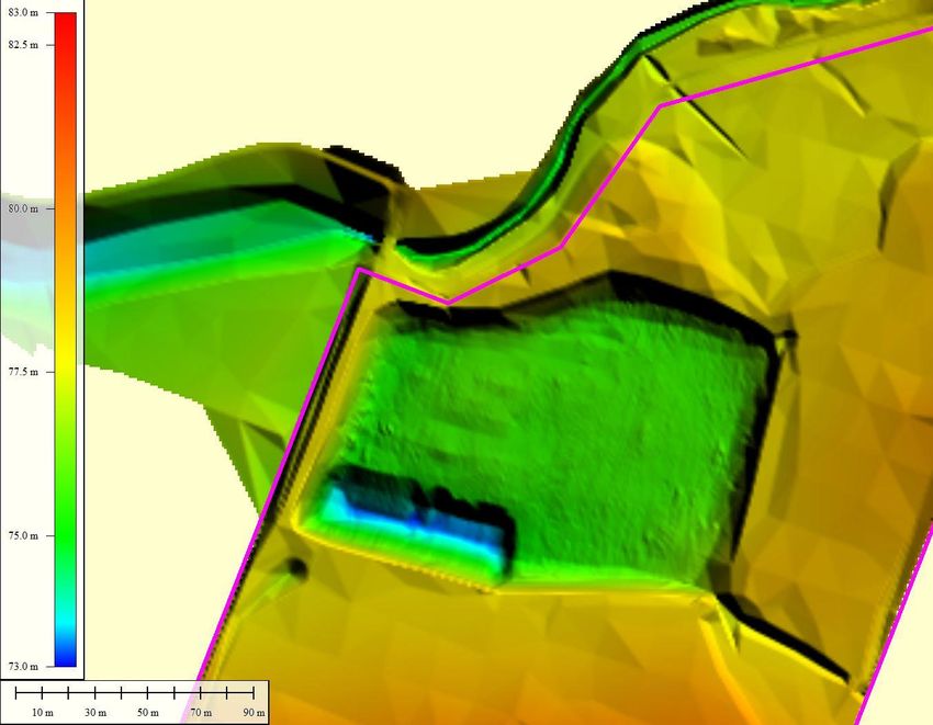
Development Victoria
621 Burwood Highway, Knoxfield

Table 2-1: 1 % AEP Event Existing Conditions Scenario with Dam Results

Peak Outflow from No Storage Model (m3/s) Peak Outflow from existing Dam Storage Peak Storage Provided within Existing Dam
                                          Model (m3/s)                           (m3)

6.2                                         3.6                                         7,090

Two future development scenarios were modelled to determine the increase in peak stormwater flow due to the development,
and to provide preliminary estimation of the requisite sizing for water storage assets. Table 2-2 summarises the final simulation
outputs for the modelled future development scenarios.

Table 2-2: 1 % AEP Event Proposed Development Scenario with Wetland/Retarding Basin Results

Peak Outflow from No Storage Model (m3/s)                         Peak Outflow from Wetland Storage Model (m3/s)

7.0                                                               3.4

Storage assets for the development scenario were iteratively sized to produce a peak outflow which was equal to or less than
the existing conditions peak outflow. The modelling assumes that the wetland is full to the extended detention depth level and
so no storage below this level is considered for flood mitigation purposes.

The modelling indicates that 7690 m3 of active storage within the wetland/ retarding basin would be sufficient to meet the flow
targets. This is only slightly more than is currently available in the existing dam up to its spillway level, however the wetland/
retarding basin is configured in a much more efficient manner. This allows for the lower flows to be discharged more quickly
and the higher flows to be held back, so that only the peak of the hydrograph is being retarded. This can be achieved with a
weir pit with a total weir length of 8 m and single 1200 mm diameter pipe discharging flows into Blind Creek.

 5                                                                                              V6000_006-REP-001-11 / February 2021
Development Victoria
621 Burwood Highway, Knoxfield

3           STORMWATER QUALITY

The State Environment Protection Policy (Waters of Victoria) defines the required water quality conditions for urban waterways.
The aim of stormwater quality treatment is to reduce typical pollutant loads from urban areas to Best Management Practices as
defined in Table 3-1 and as required by Clause 56.07-4 of the Victoria Planning Provisions.

Table 3-1: BPEMG Environmental Management Objectives for Stormwater (CSIRO, 1999)

Pollutant                                                                    Performance Objective

Total Suspended Solids (TSS)                                                 80 % reduction from typical urban load

Total Phosphorous (TP)                                                       45 % reduction from typical urban load

Total Nitrogen (TN)                                                          45 % reduction from typical urban load

Gross Pollutants (GP)                                                        70 % reduction from typical urban load

Source: Urban Stormwater: Best Practice Environmental Management Guidelines – Victorian Stormwater Committee, 1999.

To meet these objectives, Engeny propose a stormwater treatment train comprising a sediment pond and wetland, with treated
stormwater flowing into a new waterbird habitat for the FFG Act listed Blue Billed Duck and other waterbirds.

The MUSIC model was designed with input parameters generally in accordance with Melbourne Water MUSIC Guidelines
(2016), however the rainfall template used has been adjusted to one provided by Knox Council. Appendix B details the
parameter inputs utilised within the MUSIC Model. The Fair and Geyer equation was used to size the sedimentation pond.

From this, it was determined that the combination of a 1,100 square metre sediment pond plus a 4,500 square metre wetland
was sufficient to meet the water quality objectives for the development, as outlined in Table 3-2. The treatment system is
designed to treat all runoff from the development site and has been sized to achieve best practice as if there are no external
catchments flowing into the wetland. The results in Table 3-2 demonstrate that the wetland is achieving this objective. The
proposed arrangement of the wetland system is shown in Appendix C.

Table 3-2: Treatment Train Effectiveness Development area only

Pollutant                              Source (kg/yr)                        Residual (kg/yr)                         Percentage Removed

Total Suspended Solids                 24090                                 4100                                     81 %

Total Phosphorus                       48.5                                  14                                       69 %

Total Nitrogen                         338                                   167                                      46 %

Gross Pollutants                       4264                                  6                                        99.9 %

The wetland system will actually treat all of the runoff from the entire catchment, which includes existing developed catchments.
There is no legislative requirement to treat runoff from any of the existing development catchment, however given the wetland
is being constructed in a location where it can capture this flow easily, it will be treated by the wetland. Table 3-3 shows the
pollutant removal that the stormwater treatment wetland and sedimentation basin achieve relative to the amount of pollutants
generated by the development site. This tables shows that the development is removing significantly more pollutants than is
required under the BPEMG Environmental Management Objectives.

 6                                                                                                              V6000_006-REP-001-11 / February 2021
Development Victoria
621 Burwood Highway, Knoxfield

Table 3-3: Treatment Train Effectiveness including external catchments

Pollutant                        Pollutants generated by          Pollutants removed by           Percentage removed from
                                 development site (kg/yr)         treatment system (kg/yr)        development site

Total Suspended Solids           24090                            29200                           121 %

Total Phosphorus                 48.5                             48.7                            100 %

Total Nitrogen                   338                              198                             59 %

Gross Pollutants                 4264                             10141                           238 %

A complementary treatment option that could be considered within the development area is the use of rainwater tanks to help to
reduce the total volume of runoff from the development. Rainwater tanks could be installed or mandated on some or all dwellings
and plumbed to the toilets and other appropriate locations where potable water is not required, like garden taps. This provides
a constant reuse demand which reduces the total amount of stormwater runoff. By reducing the total amount of stormwater
entering the drainage system there is also a corresponding decrease in the total amount of nutrients and sediment being
discharged into the receiving waterways. The rainwater tanks are not proposed to be relied on to provide any flood mitigation
storage and have not been included in the MUSIC modelling to date to ensure that they are not being relied upon to meet the
performance targets.

3.1         WETLAND
A sedimentation basin of 1100 square metres and a stormwater treatment wetland of 4500 square metres are currently proposed.
In addition to the stormwater treatment area of the wetland an additional 10,400 square metres of habitat wetland is proposed.
This will provide a total wetland and sedimentation pond area with a footprint at the normal water level of 16,000 square metres.
The current design allows for all of these areas to function as one large wetland area with a uniform normal water level. Water
will enter the sedimentation basin in the east and then flow through the treatment wetland before passing through into the habitat
wetland. This will deliver treated stormwater to the habitat wetland, improving the quality of water for the waterbirds currently
using the site. The proposed wetland arrangement is shown in the functional design plans in Appendix C.

The sedimentation basin is separated from the wetland area to allow for more frequent maintenance without the need to disturb
the wetland. A sedimentation laydown and drying area is also provided within the design. The stormwater treatment and habitat
wetlands will appear to be the same continuous wetland area. A cutoff weir will be built at normal water level between the
treatment area and the habitat area to allow for the treatment area of the wetland to be maintained without the need to drain the
habitat wetland. Balance pipes with gate valves are also proposed between the two wetland areas to allow for even water levels
to be maintained. The low flow and high flow controls on the water levels will occur in the habitat wetland near the creek to
ensure that the wetland system does not short circuit (i.e. water will flow through the entire wetland system).

The design has been undertaken to minimise the required cut volume onsite while maximising the wetland surface area available.
Care has also been taken to minimise the impact on the larger living trees within the northern area of the site. Two dead trees
which have been identified as large or old trees will be impacted by the design. It is proposed to relocate these two dead trees
into the habitat area of the wetland as part of the construction process. This would have significant habitat benefits and in the
opinion of Ecocentric would actually increase the habitat value of the dead trees. As standing stags they would provide habitat
for the birds using the site and even as the trees degrade further and eventually collapse would create habitat for native fauna
such as frogs.

The stormwater treatment wetland will be heavily vegetated with 80 % macrophyte cover and 20 % open water. The
sedimentation basin and habitat wetland area will be mainly open water. The first four meters (horizontally) from the normal
water level will grade at 1 in 8 and will be vegetated with macrophytes. Beyond this all areas will be deeper open water. The
sediment basin will be up to 1.5 metres deep whilst the habitat wetland will be 1.5 to 2 metres deep. This depth of water is
proposed to ensure that an open waterbody is maintained and to allow for aquatic vegetation to establish and not be outcompeted

 7                                                                                              V6000_006-REP-001-11 / February 2021
Development Victoria
621 Burwood Highway, Knoxfield
by the vegetation planted on the shallow edges. Shallower water in the habitat wetland would run the risk of vegetation cover
increasing in this area.
3.1.1 Inundation Frequency
It is estimated that the total permanent pool volume of the wetland will be approximately 21,300 cubic metres. Analysis of the
bathymetric survey data suggests that the volume of water storage in the current dam to spillway level is approximately 31,000
cubic metres. The existing dam is over 4 metres deep in some areas and so a reduction in total volume of water will be required
as depths of 4 metres are not desirable in wetland systems. Additional information on the existing dam can be found in section
5.
A preliminary inundation frequency assessment has been undertaken on the whole wetland using cut volumes above normal
water level from 12d and estimated permanent pool volumes based on proposed depths. The inundation frequency was
assessed using Melbourne Water’s MUSIC Auditor. A daily flux file was output for the wetland system which produced the
results shown in Figure 3-1. In addition to the information displayed in the figure the:
• Water level exceeded for 20 % of time: 0.10 m
• Water level exceeded for 50 % of time: 0.0267 m. Effective water level is within 50 mm of normal water level and is acceptable
• 90th Percentile Residence Time: 8 days
• 300 mm depth in the wetland was exceeded for one day only, 13 times in the data set (10 years) analysed.
These results show that the proposed wetland setup provides an acceptable inundation frequency to provide conditions for
healthy plant growth.
Figure 3-1: Inundation Frequency analysis
8 V6000_006-REP-001-11 / February 2021Development Victoria 621 Burwood Highway, Knoxfield 3.1.2 Construction staging It is proposed that the construction of the habitat wetland occurs before the existing dam onsite is decommissioned. An establishment period would also be allowed so that the vegetation within the deeper waters of the habitat wetland are confirmed to be growing well and are healthy. This will allow the water birds that are currently using the site to transition from the existing dam to the new habitat wetland and will ensure that they will not be left without habitat during the construction process. It is expected that the construction and establishment period for the habitat wetland will take approximately 12 months. Ideally the construction would be timed to minimise the disruption to the breeding water birds at the site, however it is understood that not all water birds breed at the same time of the year and that disruption to some species is likely to be unavoidable. From an engineering perspective it would be easier if the earth moving stages of the construction could be timed to occur in summer or autumn when ground conditions will be easier to work with than in winter or early spring. 3.2 HABITAT CREATION The existing dam on the site provides habitat for water birds and aquatic vegetation. The Ecocentric report (2017) notes that, “water quality appears to vary at the site based on prevailing conditions, and was ostensibly relatively poor during winter surveys. Waters were very turbid during field surveys, and a thin ‘slick’ of a contaminant (i.e. hydrocarbon) was observed on part of the water surface on 5 July 2017”. Currently the water in the dam receives no treatment prior to entering the dam. It is currently fed by an urbanised catchment of approximately 25 ha and approximately 20 ha of the existing horticulture site. The proposed wetland setup should improve the quality of stormwater entering the habitat wetland. The Ecocentric report (2017) states that two Blue-billed Ducks, a listed species, are residing permanently at the site. It also notes that “the site lacks the dense marginal vegetation and reed beds (i.e. for nest-building) that are generally associated with the successful breeding of this species (Marchant & Higgins 1990)”. The report also states that Australian Wood Ducks and the Pacific Wood Ducks are breeding at the site. The proposed wetland system will significantly improve the available breeding habitat for waterbirds, with significantly more dense marginal vegetation and reed beds to be provided within both the treatment and habitat areas of the wetland. Dense screening vegetation would also be planted on the embankment batter slopes to discourage access to the wetland. This vegetation will also provide good habitat for native fauna. 3.3 ADDITIONAL BENEFITS OF WETLAND ASSETS 3.3.1 Integration and public use The proposed sedimentation basin, stormwater treatment wetland and habitat wetland should be integrated into the development area. Consideration has been given as to how to encourage safe use of the wetland area for the public. There is currently a dual purpose access and maintenance path running between the sedimentation basin and the stormwater treatment wetland. This access path will provide an active link to the Blind Creek corridor. An additional path may be able to be provided on the western side of the sedimentation basin if this is required. A road will run along the southern boundary of the wetland and the existing Blind Creek Trial runs along the northern boundary. It is not proposed to provide a link along the eastern edge of the habitat wetland. This is at the advice of Ecocentric ecologists who have highlighted that providing a path in this location would increase the disturbance of the water birds that this habitat wetland is aiming to attract. The advice from Ecocentric has been that minimising public access to the wetland will be beneficial for encouraging use of the area by waterbirds. The existing dam on the site currently has no public access and so the development of the site will inherently bring people and their pets closer to the creek corridor. Using dense vegetative screening around the edge wetland will help to minimise this disturbance and also create habitat for waterbirds and other animals. 3.3.2 Integrated Water Cycle Management Consideration could be given to allowing harvesting from the wetland system. The total volume of water stored by the wetlands is very large (approximately 21 ML) and a small portion of this could be used for reuse in surrounding areas. A detailed water balance study would be needed to quantify the amount of water that would be harvested without negatively impacting on the function of the wetland area and to determine the reliability of supply to determine if this is feasible. The current design of the wetland would allow for stormwater harvesting if it is deemed feasible. 9 V6000_006-REP-001-11 / February 2021
Development Victoria
621 Burwood Highway, Knoxfield

Possible demand for use of treated stormwater in the adjacent area could come from:

•        third pipe system through the development
•        Fairhills High School playing fields
•        existing community garden on the northern side of Blind Creek
•        open spaces within the development area.

In order to safely reuse the stormwater some additional treatment, such as ultra violet light filtration may be necessary.

    10                                                                                           V6000_006-REP-001-11 / February 2021
Development Victoria
621 Burwood Highway, Knoxfield
4 FLOOD MODELLING OF BLIND CREEK
Blind Creek is a Melbourne Water managed waterway. Melbourne Water has indicated that flood modelling of Blind Creek for
existing conditions and developed conditions of the site was required.
Melbourne Water provided Engeny with a RORB model and details of the Melbourne Water drainage infrastructure within the
creek corridor to use in the flood modelling. Using this information and Lidar data Engeny has created a Tuflow model of Blind
Creek from Scoresby Road to Lewis Road. Details of the RORB modelling and the Tuflow modelling techniques are contained
in Appendix D.
The RORM model shows that the peak flows on Blind Creek occur in the 2 hour event. The peak 1 % AEP flow is 41.8 m3/s.
The full hydrograph from RORB has been used in the Tuflow modelling for both the existing and developed Tuflow models.
A fixed tailwater level was used for the modelling set at the 1 % AEP flood level supplied by Melbourne Water downstream of
the development site. This boundary condition provides a conservative estimate of downstream flood levels.
4.1 EXISTING CONDITIONS
For the existing conditions model it was assumed that the existing dam was full to its spillway level of 77.54 m AHD.
Appendix E shows the results from the Tuflow flood modelling for the existing conditions.
The Tuflow modelling results show that the dam embankment is overtopped and that there is flooding in the neighbouring
industrial precinct to the west. There is a significant hydraulic control at the point where the Blind Creek Trail crosses over Blind
Creek. At this point there is a drop structure and the low flows in the waterway are piped downstream of this point.
The estimated total volume of floodplain storage on the site is 21,000 m 3.
Melbourne Water has provided flood levels for the subject property. These flood levels are recorded in the north west and north
east corners of the property. Table 4-1 shows the flood levels provided by Melbourne Water and a comparison to the results
from the Engeny flood modelling. The table shows that there is a good match between the two sets of flood levels.
Table 4-1: Flood level comparison
North West Corner (m AHD) North East Corner (m AHD)
Melbourne Water flood level 77.0 78.85
Engeny existing conditions flood level 77.06 78.88
4.2 DEVELOPED CONDITIONS
The same base Tuflow model was used for the developed conditions as the existing conditions. The hydrology was unchanged,
as were the Manning’s n roughness values in Blind Creek and all other areas not impacted by the development works.
The proposed wetlands were modelling using a design DEM from 12d to represent the surface of the proposed wetland. It was
assumed that the wetland was full to normal water level at the start of the flood simulation. It was also assumed that all areas of
the development site south of the proposed wetland would be filled at least 600 mm above the flood level.
Appendix E shows the results from the Tuflow flood modelling for the developed conditions and also shows an afflux map
showing the differences in flood levels between existing and developed conditions.
The modelling shows that there is no change in flood levels upstream of the development area. This includes the neighbouring
residential area directly to the east of the development area. The modelling also shows that there is a reduction in flood levels
in Blind Creek adjacent to the development area, as a result of the increased storage provided in the floodplain by the new
wetland. Downstream of the proposed wetland the modelling shows that there is an increase in flood levels within the waterway
11 V6000_006-REP-001-11 / February 2021Development Victoria
621 Burwood Highway, Knoxfield
and a decrease in both the flood level and the area flooded in the adjacent industrial areas. Directly downstream of the
sedimentation basin there is a moderate increase in flood level over up to 0.2 metres but this is contained to the waterway
corridor and dissipates back to zero within 75 metres.
In their predevelopment advice Melbourne Water stated that no increase in flood levels and no net loss of floodplain storage
would need to be demonstrated for developed conditions. The proposed works increase floodplain storage but do increase flood
levels in Blind Creek downstream of the site. Table 4-2 compares the floodplain storage during existing and developed
conditions. It shows that available floodplain storage on the site is proposed to be increased by 12 600 m 3.
Table 4-2: Floodplain storage in 1 % AEP
Floodplain storage (m3)
Existing conditions 21 000
Developed conditions 33 600
The increase in flood levels in Blind Creek is occurring is due to a reduction in flooding of the industrial areas adjacent to the
creek. In Engeny’s view this is an improvement on existing conditions as more water is being contained within the waterway
corridor and additional properties are being protected from flooding by narrowing the flow path and preventing spills into the
neighbouring industrial areas. It should be noted that the dam on the site is not a naturally occurring structure and that it is
directly contributing to the flooding of some of the adjacent properties by artificially raising flood level upstream of the existing
dam embankment wall.
Despite the increase in total floodplain storage there is also a slight increase in the peak flows recorded downstream of
development area. Figure 4-1 shows the difference in the existing conditions hydrograph (blue line) and the developed conditions
hydrograph (green line). The comparison shows that there is a slight increase in peak flows as a result of reshaping the
floodplain, but that the total volume of flow discharging downstream is reduced (i.e. the area under the hydrograph is less under
developed conditions).
Figure 4-1: Hydrograph from Tuflow modelling 360 m downstream of the development site
12 V6000_006-REP-001-11 / February 2021Development Victoria 621 Burwood Highway, Knoxfield It is noted that the developed conditions flood modelling is based on a DEM from the Engeny 2017 wetland design. This developed case flood mapping will be updated once the current PGA design has been further progressed. It is not expected that there will be any significant changes once the updated design is modelled as the design concept is very similar and achieves similar volumes of excavation and cut within the site. 13 V6000_006-REP-001-11 / February 2021
Development Victoria
621 Burwood Highway, Knoxfield

5         EXISTING DAM

A preliminary biodiversity assessment was undertaken by Ecocentric Environmental consulting (2015). The report found that
"the wetland at the site is large in area and provides habitat for wetland birds, including the threatened Blue-billed Duck, which
was recorded on site during the current assessment. Any proposal to impact the wetland at the site, through the compete
removal, re-design or any other wetland modification, should be undertaken with careful consideration, and planning and in
consultation with an ecologist in order to avoid and minimise impacts to significant wetland species (both flora and fauna taxa)”.
In its current form the existing dam is not engineered to provide stormwater treatment. It also currently receives untreated
stormwater from the upstream urban catchment. Stormwater treatment wetlands require large areas of shallow water with a
high proportion of vegetation cover. They also require gently sloped ephemeral banks which can be subject to regular wetting
and drying to assist in sediment and nutrient removal. Given that the dam is over 4 m deep in some parts regrading the internal
floor of the dam to be in the order of 1 - 0.5 m deep will require significant filling. Figure 5-1 shows the topography and bathymetry
of the dam and surrounding area based on survey undertaken in July 2017.

Maintaining the dam on the site poses a number of challenges and it is likely that better environmental outcomes could be
achieved through the removal of this dam and construction of water bird habitat in the adjacent area rather than retrofitting the
dam to provide stormwater treatment.

Figure 5-1: Topography and bathometry of the existing dam based on survey data

 14                                                                                                V6000_006-REP-001-11 / February 2021
Development Victoria
621 Burwood Highway, Knoxfield

5.1            CURRENT CONDITION OF THE DAM
The Dam Condition Assessment Report by Engeny 2017 provides details on the current condition of the dam. The condition of
the dam is summarised in that report as follows:

Based on the site inspection observations the dam is currently considered to be in fair to poor condition. A number of existing
defects / deficiencies were identified which have the potential to lead to dam failure in time if left to progressively deteriorate
without intervention.

The desktop failure modes assessment identified that the existing spillway doesn’t have capacity to pass even the 63 % AEP
event. This is significantly lower than the minimum spillway capacity of 1 % AEP recommended by industry guidelines (ANCOLD)
for even low consequence category dams. Overtopping of the dam embankment crest would be expected to occur on a regular
basis, which significantly increases the likelihood of dam failure.

The conclusions and recommendations of the dam conditions report state the following:

The Dam is not currently considered fit for purpose and would only be considered to be suitable for on-going use if the following
upgrades / remedial works are completed:

•        Upgrade the spillway to provide capacity to convey, as a minimum, the 1 % AEP rainfall event plus the 10 % AEP wave
         freeboard. To provide the recommended spillway capacity will require raising or relocation of the existing dam embankment.
         Raising the embankment to ensure that it is not overtopped in a 1 % AEP event may impact on flooding behaviour within
         Blind Creek and could increase flood levels within the creek in a 1 % AEP event. This would need to be investigated and
         any increase in flood levels approved by Melbourne Water
•        Undertake the following remedial works to repair existing dam embankment defects:

         ‒   Modify existing uneven embankment surface levels (ruts, depressions, etc) to reduce the likelihood of rill erosion due to
             concentrated runoff
         ‒   Repair longitudinal cracks
         ‒   Repair void in downstream shoulder adjacent to pit
         ‒   Repair existing erosion on downstream batter in north-west corner of dam and stabilise embankment
         ‒   Protect the upstream batter slope from further erosion / steepening / slumping.

•        Develop an operational plan for the Dam which defines roles and responsibilities, surveillance, monitoring and maintenance
         requirements.

5.2            REMOVAL OF THE EXISTING DAM
The key reasons for removing the dam are that the:

•        Embankment is of unknown construction materials and quality
•        The current condition of the dam is fair to poor. It is unlikely that Council would consider accepting the dam as their asset to
         manage in its current condition
•        The dam does not have a spillway with adequate capacity to pass even moderate rainfall events, with the capacity estimated
         to be exceeded a 63 % AEP event (1 year ARI)
•        The dam embankment is very close to the existing development to the west and the water level is above some of the
         development, creating a potential issue should the dam embankment fail
•        The dam fills with untreated stormwater and its current design is not suitable to provide stormwater treatment. Retro fitting
         the existing dam to provide stormwater treatment will have a significant detrimental impact on the existing fauna and flora
         current at the site during construction as heavy earth moving equipment will be required to be used in the dam to flatten the
         batters on the dam edges. The existing normal water level of the dam (77.54 m AHD) and the incoming invert of the pipe for
         Fairhills High School (77.88) will make it difficult to provide stormwater treatment upstream of the existing dam but within the
         development area as there is very little fall between these two points
•        The dam provides limited flood storage as it is usually full to full supply level

    15                                                                                                 V6000_006-REP-001-11 / February 2021
Development Victoria
621 Burwood Highway, Knoxfield
• The steep batter slopes of the dam below the normal water level do not comply with safety requirements for urban public
water bodies. Guidelines from the Royal Life Saving Society Australia (2004) state that safety benches with a maximum
grade of 1:8 (V:H) for the first 1.5-3.0 m from the edge of the bank are required prior to transitioning to steeper grades. It
also states that the “safety bench shall be densely planted such that casual entry will be difficult and that depths gradually
increase beyond 150-200 mm before deepening.”
Engeny has discussed the existing dam with Peter Gannon from Ecocentric Environmental Consulting. Peter agreed that the
current dam is not configured to provide stormwater treatment, and that the works that would be required on the dam to retrofit
it to be able to provide the necessary stormwater treatment would be a significant disturbance to the existing fauna and flora.
Heavy earthmoving equipment would be required to operate in and around the edge of the dam to create safer shallower batter
slopes and the water quality within the dam would be significantly impacted during this works period. The option of constructing
a new stormwater treatment and wetland habitat adjacent to the existing dam has the potential to minimise the disturbance to
the existing fauna on the site as the construction will be staged so that the new wetland is built before the existing dam is filled
in.
16 V6000_006-REP-001-11 / February 2021Development Victoria
621 Burwood Highway, Knoxfield
6 STORMWATER MANAGEMENT PLAN
This stormwater management plan for 621 Burwood Highway Knoxfield has been developed following discussions with
Development Victoria, Knox City Council, Melbourne Water and Ecocentric Consulting. This plan represents a considered
design response, however additional minor changes to the operation scheme of the wetlands may be required within the
proposed footprints. The review and changes will consider the relevant planning controls, both zoning and overlays, along with
the requirements needed to meet the best practice targets for stormwater management.
The stormwater management plan for the site has been designed to:
• Achieve multiple benefits for the environment and the community
• Comply with all environmental requirements
• Solve a number of problems with the existing dam on the site, including the existing dam embankment, poor water quality in
the dam, limited flood mitigation effect of the dam, proximity of the dam to Blind Creek and safety problems with the dam
water body
• Provide improved habitat compared with the existing dam for all flora and fauna
• Provide public access to a significant new open space area within the site
• Treat runoff to significantly exceed the Best Practice target requirements for treating runoff from the site
• To provide an Integrated Water Management system for the site to reduce potable water demand, wastewater discharges
and stormwater runoff.
17 V6000_006-REP-001-11 / February 2021Development Victoria 621 Burwood Highway, Knoxfield 7 CONCLUSIONS AND RECOMMENDATIONS Engeny has assessed the extent of works that are required to manage the stormwater quantity and quality issues associated with the development of the property at 621 Burwood Highway in Knoxfield. The developer will be required to limit the peak outflows from the site to the current existing condition flows. This will require the construction of a retarding basin with approximately 3,000 m 3 of active storage. The most logical location for this retarding basin is in the north of the site adjacent to Blind Creek as all of the site can be drained to this location. At this location it could also be co-located with a wetland to provide stormwater treatment. The developer will also be required to treat the stormwater runoff from the site to meet best practice environmental guidelines. The most cost effective and lowest maintenance way to achieve this would be with a single wetland and sedimentation basin system located adjacent to Blind Creek. The design work undertaken in MUSIC suggests that a 1100 m 2 sedimentation pond and a 4500 m2 wetland will meet this best practice targets. The existing dam on the site has been identified as having environmental values, in particular as a habitat for waterbirds including the blue billed duck. Despite its environmental values it poses a management challenge as it was originally constructed as a dam and not designed as an urban water body with unrestricted public access. Engeny recommend removing the dam and constructing a stormwater treatment wetland and waterbird habitat wetland on the adjacent vacant land to the north east of the existing dam. The construction of the habitat wetland can be staged so that the current dam is maintained in its existing condition throughout the construction period. Flood modelling has been undertaken to model the impact of the development on upstream and downstream flood level. Net floodplain storage is increased under the currently proposed wetland system. Flood levels upstream of the development area are not increased and while flood levels downstream do increase within a localised area of Blind Creek, there are significant reductions in flood levels in the adjacent industrial area which offsets those minor increases which are contained to the waterway corridor. 18 V6000_006-REP-001-11 / February 2021
Development Victoria
621 Burwood Highway, Knoxfield

8          QUALIFICATIONS

      a)     In preparing this document, including all relevant calculation and modelling, Engeny Water Management (Engeny)
             has exercised the degree of skill, care and diligence normally exercised by members of the engineering profession
             and has acted in accordance with accepted practices of engineering principles.
      b)     Engeny has used reasonable endeavours to inform itself of the parameters and requirements of the project and
             has taken reasonable steps to ensure that the works and document is as accurate and comprehensive as possible
             given the information upon which it has been based including information that may have been provided or obtained
             by any third party or external sources which has not been independently verified.
      c)     Engeny reserves the right to review and amend any aspect of the works performed including any opinions and
             recommendations from the works included or referred to in the works if:

             i)     Additional sources of information not presently available (for whatever reason) are provided or become
                    known to Engeny; or
             ii)    Engeny considers it prudent to revise any aspect of the works in light of any information which becomes
                    known to it after the date of submission.

      d)     Engeny does not give any warranty nor accept any liability in relation to the completeness or accuracy of the
             works, which may be inherently reliant upon the completeness and accuracy of the input data and the agreed
             scope of works. All limitations of liability shall apply for the benefit of the employees, agents and representatives
             of Engeny to the same extent that they apply for the benefit of Engeny.
      e)     This document is for the use of the party to whom it is addressed and for no other persons. No responsibility is
             accepted to any third party for the whole or part of the contents of this Report.
      f)     If any claim or demand is made by any person against Engeny on the basis of detriment sustained or alleged to
             have been sustained as a result of reliance upon the Report or information therein, Engeny will rely upon this
             provision as a defence to any such claim or demand.
      g)     This Report does not provide legal advice.

19                                                                                              V6000_006-REP-001-11 / February 2021
Development Victoria 621 Burwood Highway, Knoxfield 9 REFERENCES CSIRO 1999, Urban Stormwater Best Practice Environmental Management Guidelines (BPEMG). Ecocentric Environmental Consulting 2015, Preliminary Biodiversity Assessment 609-619 & 621 Burwood Highway Knoxfield. Ecocentric Environmental Consulting 2017 Flora, Fauna and Native Vegetation Assessment 609-619 & 621 Burwood Highway Knoxfield. Engeny, 2017 Dam Condition Assessment Report – 621 Burwood Highway, Knoxfield. Marchant, S. & Higgins, P. J. (eds) (1990). Handbook of Australian, New Zealand & Antarctic Birds. Vol 1A: Ratites to Ducks. Oxford University Press: Melbourne. The Royal Life Saving Society Australia, 2004, Royal Life Saving Guidelines for Water Safety in Urban Water Developments. GHD 2015, 621 Burwood Highway, Knoxfield Development Assessment. 20 V6000_006-REP-001-11 / February 2021
Development Victoria
621 Burwood Highway, Knoxfield

Appendix A:
Hydrologic Calculations and RORB
Model Parameters

21/38                            V6000_006-REP-001-11 / February 2021
Development Victoria
621 Burwood Highway, Knoxfield

A.1        RORB MODEL SUBCATCHMENT PARAMETERS
Subcatchments within the development area were delineated using local elevation contours and the proposed development
densities (Figure 2-1). An additional subcatchment was drawn over the existing dam, with the model assuming the relocation of
this waterbird habitat. Catchments were also delineated to represent external inflows from the existing residential area to the
east and the DELWP Precinct to the south, using elevation contours and the existing drainage network. An overview of the
RORB Model layout utilised is provided in Appendix Figure A- 1.

Fraction impervious values for these subcatchments varied across the modelled scenarios. Appendix Table A- 1 summarises
the fraction impervious values applied within the various models. Aerial imagery and planning zones were utilised to calculate
these values in the existing development scenarios. The Development Masterplan (Figure 2-1) was utilised to assign
representative fraction impervious values to select subcatchments within the future development scenarios.

Appendix Table A- 1: RORB Subcatchment Area and Fraction Impervious Values (Existing Conditions)

Subcatchment                                Area (km2)                            Existing Conditions

                                                            Direct Fraction       Indirect Fraction     Total Fraction Impervious

A (Existing Residential)                    0.033           0.367                 0.633                 0.611

B (Existing Residential)                    0.059           0.360                 0.640                 0.600

C (Existing Residential)                    0.071           0.360                 0.640                 0.600

D (Existing Residential)                    0.058           0.370                 0.630                 0.616

E (Fairhill High School)                    0.057           0.300                 0.700                 0.500

F (DELWP Precinct)                          0.013           0.420                 0.580                 0.700

G (Development)                             0.056           0.090                 0.060                 0.150

H (Development)                             0.038           0.240                 0.760                 0.400

I (Development)                             0.022           0.060                 0.040                 0.100

J (Development)                             0.023           0.060                 0.040                 0.100

K (Former Dam – Development and Wetland)    0.008           0.060                 0.040                 0.100

L (Former Dam – Development and Wetland)    0.027           0.060                 0.040                 0.100

M (Proposed Wetland)                        0.019           0.060                 0.040                 0.100

Appendix Table A- 2: RORB Subcatchment Area and Fraction Impervious Values (Developed Conditions)

Subcatchment                                Area (km2)      Existing Conditions

                                                            Direct Fraction       Indirect Fraction     Total Fraction Impervious

A (Existing Residential)                    0.033           0.367                 0.633                 0.611

B (Existing Residential)                    0.059           0.360                 0.640                 0.6

C (Existing Residential)                    0.071           0.360                 0.640                 0.6

D (Existing Residential)                    0.058           0.370                 0.630                 0.616

                                                                                                 V6000_006-REP-001-11 / February 2021
Development Victoria
621 Burwood Highway, Knoxfield
Subcatchment Area (km2) Existing Conditions
Direct Fraction Indirect Fraction Total Fraction Impervious
E (Fairhill High School) 0.057 0.419 0.581 0.698
F (DELWP Precinct) 0.013 0.361 0.639 0.601
G (Development) 0.056 0.539 0.461 0.898
H (Development) 0.038 0.463 0.537 0.771
I (Development) 0.022 0.464 0.536 0.774
J (Development) 0.023 0.47 0.53 0.781
K (Former Dam – Development and Wetland) 0.008 0.12 0.08 0.206
L (Former Dam – Development and Wetland) 0.027 0.32 0.68 0.538
M (Proposed Wetland) 0.019 0.06 0.04 0.1
A.2 RORB MODEL STANDARD PARAMETERS
Local rainfall IFD data for the Knoxfield area was sourced from the Bureau of Meteorology. Standard parameters utilised across
the various RORB models are sourced from ARR Data Hub, outlined in Appendix Table A- 3.
Appendix Table A- 3: RORB Model Parameters
Rural IL (mm) Rural CL (mm) kc m
23 3.8 1.03 0.8
The kc was calculated using the Dandenong Valley Authority (DVA) k c Equation. The catchment being modelled falls within the
greater Dandenong Creek catchment. As an additional validation check a flow comparison was undertaken comparing the RORB
outputs from a RORB model with no retarding basins or dams included to the DRNE flood flow regression analysis for urban
catchments. Appendix Table A- 4 shows that there is a close match between the flow estimates using the RORB model under
both existing and developed conditions and the DNRE regression flow value. This indicates that the k c value selected is
appropriate.
Appendix Table A- 4: Flow validation
Flow estimation method Flow (m³/s)
DRNE equation 6.2
RORB model existing conditions no dam 6.2
RORB model future development no RB 7.0
Appendix Table A- 5 and Appendix Table A- 6 shows the stage storage relationships used in the RORB modelling and the
overflow weir details respectively of the developed conditions retarding basin.
V6000_006-REP-001-11 / February 2021Development Victoria
621 Burwood Highway, Knoxfield
Appendix Table A- 5: Stage Storage curve for RORB model
Elevation (m AHD) Storage Volume (m3)
76.850 0
76.900 912.838
77.000 2828.159
77.100 4868.025
77.200 7013.458
77.300 9229.903
77.400 11492.1
77.500 13795.9
77.600 16140.88
77.700 18526.87
77.7500 19734.38
Appendix Table A- 6: RORB outflow setup details
Crest Elevation (m AHD) Weir Length (m)
76.85 (at EDD level) 8.0
77.70 (blockage or extreme event overflow only) 20.0
Appendix Table A- 7 shows the peak discharge and storage above the extended detention depth achieved in each AEP event
under developed conditions.
Appendix Table A- 7: RORB Storages and outflows
AEP event Peak outflow (m3/s) Critical duration Median Temporal Storage (m3) Peak Water Level (m
Pattern AHD)
63 % 1.3 2 hour Tp 4 4030 76.85
39 % 1.6 1 hour Tp 4 3180 76.85
18 % 2.5 1 hour Tp 5 6770 76.86
10 % 2.7 1 hour Tp 15 6880 76.89
5% 2.9 1 hour Tp 15 10000 76.94
2% 3.2 1 hour Tp 29 12300 77.01
1% 3.4 1 hour Tp 27 14500 77.08
V6000_006-REP-001-11 / February 2021Legend
RORB Node
RORB Reach
RORB Subcatchment Boundary
RORB Catchment Boundary
Watercourses
Suite 15, 333 Canterbury Rd, Canterbury VIC 3126 100 0 100 200 m
621 Burwood Highway, Knoxfield
PO Box 452 Canterbury VIC 3126
www.engeny.com.au
Map Projection: Tranverse Mercator Job Number: V6000_002
P: 03 9888 6978 Horizontal Datum: Geocentric Datum of Australia Revision: 1
F: 03 9830 2601
Vertical Datum: Australia Height Datum
Grid: Map Grid of Australia, Zone 55
Stormwater Management Plan Drawn: VW
E: melb@engeny.com.au RORB Model Layout Checked: GO
Data Source: DELWP: VicMap - Sep 2016 Date: 26/7/2017
Figure 9.1Development Victoria 621 Burwood Highway, Knoxfield Appendix B: Water Quality Calculations and MUSIC Model Parameters 5/38 V6000_006-REP-001-11 / February 2021
Development Victoria
621 Burwood Highway, Knoxfield

B.1       MUSIC MODEL PARAMETERS
The MUSIC model was designed and input parameters specified as generally as per the Melbourne Water MUSIC Guidelines
(2016). The rainfall template utilised was supplied by Knox City Council and includes five years of rainfall data.

A simplified version of the RORB subcatchment layout was used to develop the MUSIC model, external catchments with similar
fraction impervious values were merged. The catchment was modelled with seven urban nodes to represent the varying
residential housing densities within the Knoxfield Development, the DELWP Precinct to the south and the established residential
area to the east. Appendix Figure B- 1 provides an overview of the MUSIC model setup that was used to assess the treatment
for development areas. Appendix Figure B- 2 shows the MUSIC model setup for the whole catchment that was used to assess
the inundation frequency of the wetland system.

The sediment pond was sized using the Fair and Geyer Equation. A 1,100 square metre basin was calculated to meet the target
of 95 % particle capture efficiency, for combined inflows from the Site and the neighbouring residential and commercial areas.

The sediment basin was subsequently modelled as an inlet pond of 707 cubic metres in volume, assuming a rectangular shape
incorporating safety benches. The wetland was sized using an iterative process to achieve the BPEMG targets outlined in Table
3-1.

Appendix Figure B- 1: MUSIC Model Layout for Development Area

                                                                                              V6000_006-REP-001-11 / February 2021
Development Victoria
621 Burwood Highway, Knoxfield
Appendix Figure B- 2: MUSIC Model Layout for Whole Catchment
V6000_006-REP-001-11 / February 2021Development Victoria 621 Burwood Highway, Knoxfield Appendix C: Proposed Wetland Design Plans 3/38 V6000_006-REP-001-11 / February 2021
NOT FOR CONSTRUCTION

Plot Date: 5 July 2017 - 9:59 AM   Plotted by: ----   Cad File No:   V:\Projects\V6000 Places Victoria\V6000_002 621 Burwood Highway SWMP\05 Design\AutoCAD\Drawings\V6000-002-C001.dwg
NOT FOR CONSTRUCTION

Plot Date: 5 July 2017 - 10:43 AM   Plotted by: ----   Cad File No:   V:\Projects\V6000 Places Victoria\V6000_002 621 Burwood Highway SWMP\05 Design\AutoCAD\Drawings\V6000-002-C010.dwg
NOT FOR CONSTRUCTION

Plot Date: 5 July 2017 - 10:52 AM   Plotted by: ----   Cad File No:   V:\Projects\V6000 Places Victoria\V6000_002 621 Burwood Highway SWMP\05 Design\AutoCAD\Drawings\V6000-002-C020.dwg
NOT FOR CONSTRUCTION

Plot Date: 11 July 2017 - 4:05 PM   Plotted by: ----   Cad File No:   V:\Projects\V6000 Places Victoria\V6000_002 621 Burwood Highway SWMP\05 Design\AutoCAD\Drawings\V6000-002-C021.dwg
NOT FOR CONSTRUCTION

Plot Date: 5 July 2017 - 10:57 AM   Plotted by: ----   Cad File No:   V:\Projects\V6000 Places Victoria\V6000_002 621 Burwood Highway SWMP\05 Design\AutoCAD\Drawings\V6000-002-C030.dwg
NOT FOR CONSTRUCTION

Plot Date: 27 July 2017 - 8:19 AM   Plotted by: ----   Cad File No:   V:\Projects\V6000 Places Victoria\V6000_002 621 Burwood Highway SWMP\05 Design\AutoCAD\Drawings\V6000-002-C031.dwg
NOT FOR CONSTRUCTION

Plot Date: 5 July 2017 - 10:58 AM   Plotted by: ----   Cad File No:   V:\Projects\V6000 Places Victoria\V6000_002 621 Burwood Highway SWMP\05 Design\AutoCAD\Drawings\V6000-002-C040.dwg
Development Victoria
621 Burwood Highway, Knoxfield

Appendix D:
Blind Creek RORB and Tuflow
modelling

4/38                             V6000_006-REP-001-11 / February 2021
Development Victoria
621 Burwood Highway, Knoxfield

D.1        RORB MODEL
Melbourne Water provided Engeny with a RORB model for the Blind Creek catchment. The RORB model was run in accordance
with the parameters specified in the model and as confirmed with Melbourne Water. These key parameters were:

•    Kc = 19.83
•    m = 0.8
•    Initial Loss (IL) = 10 mm
•    1 % AEP event Runoff Coefficient = 0.6
•    Filtered Temporal patterns
•    Uniform Aerial Pattern
•    Areal Reduction Factor in accordance with ARR87 Book 2 (replace total catchment area with a value of 20 km 2)

Appendix Table D- 1: Blind Creek RORB IFD data

Variable                                                  Blind Creek Values

2 year 1 hour intensity                                   18.5

2 year 12 hour intensity                                  4.9

2 year 72 hour intensity                                  1.4

50 year 1 hour intensity                                  36.5

50 year 12 hour intensity                                 8

50 year 72 hour intensity                                 2.5

Skew                                                      0.36

F2                                                        4.28

F50                                                       15

Zone                                                      1

The model was run for the full range of 1 % AEP storms from 10 minute to 72 hour using Australian rainfall and runoff 1987
intensity frequency duration data (as shown in Appendix Table D- 1). The 2 hour event was identified as having the greatest
peak flow just upstream of the development site and so this event was used in the assessment of both existing and developed
conditions.

The flow input to the Tuflow model were taken from the RORB hydrograph identified in the RORB model outputs as “59
Calculated hydrograph, Downstream Scoresby Rd”.

D.2        TUFLOW MODELLING
A Tuflow model was developed for the study area. The layout of the model is shown in Figure 1-1. The model extents from
Scoresby Road to Lewis Road and was wide enough to encompass the entire floodplain. A flow vs time inflow boundary was
used at the upstream end of the model to insert flows into the model and a fix level head vs time boundary was used at the
downstream end of the model to drain the water out. The head level was based on Melbourne Water’s 1 % AEP flood level at
Lewis Road. The Mannings roughness values were assigned back on inspection of an aerial photograph from NearMap and on
observations made on the site visit. All areas were initial assigned a value corresponding to remainder of parcel (representing
gardens and fences in backyards of properties) and individual values were applied based on the land use as per the aerial
photography. Appendix Table D- 2 shows the Mannings n values used in the Tuflow modelling.

                                                                                              V6000_006-REP-001-11 / February 2021
You can also read