Using stable isotopes as tracer to investigate hydrological condition and estimate water residence time in a plain region, Chengdu, China
←
→
Page content transcription
If your browser does not render page correctly, please read the page content below
www.nature.com/scientificreports
OPEN Using stable isotopes as tracer
to investigate hydrological
condition and estimate water
residence time in a plain region,
Chengdu, China
Jing Zhou1,2, Guodong Liu1,2, Yuchuan Meng1,2*, ChengCheng Xia1,2, Ke Chen1,2 & Yu Chen1,2
The oxygen and hydrogen isotopic compositions (δ18O and δ2H) were measured on river water
and precipitation collected from four sub-catchments within the upper Tuojiang River catchment.
δ18O values of river water and precipitation exhibit significant seasonal variations. These seasonal
variations are used for estimating the mean residence time (MRT) for four sub-catchments by an
exponential model, ranging from 346 to 493 days. The correlation between catchment MRT and mean
slope of the catchment (r2 = 0.29) is weak, while the correlations between catchment MRT, catchment
area (r2 = 0.79) and topographic index (r2 = 0.98) are strong. These results indicate that topography
and catchment area, both control the catchment MRT and the topographic index may be a reliable
parameter for estimating the catchment MRT. Moreover, the relationship between land use types
and MRT was investigated. The results show that paddy fields (r2 = 0.95) compared to the other land
use types may have a greater impact on the MRT of the irrigation-dominated catchment. This study
provides a preliminary exploration of the factors affecting MRT in the plain region and a basis for
simulating MRT in the future.
The catchment hydrological process is complex and it is difficult to observe how rivers respond to precipitation
events. Over the past three decades, hydrologists are starving to figure out how to improve our understanding
of the process and quantitative knowledge at scales where water resource decision was o btained1. As advances
in measurement techniques are achieved, isotope technology provides important insight in better understand-
ing the hydrological p rocess2–4. The residence time refers to the time water travels through the subsurface of the
catchment after its input as precipitation5. MRT is an important descriptor of catchment hydrology to indicate
storage, flow path and source of water in an integrated m easurement6. Damping of tritium (3H/1H), variations
of stable oxygen (18O/16O) and hydrogen (2H/1H) isotopic signature in both precipitation and river water have
been proved useful for estimating the MRT of catchment7–10. The distribution of water residence time in catch-
ments is not only a reflection of flow pathway and storage, but also an important indicator for water quality as
biogeochemical reaction relates directly to time11. Longer residence time means longer contact time with catch-
ment. Therefore, by quantifying the MRT, important information about hydro-chemical systems, hydrological
sensitivity to human activities and climatic changes could be r evealed12,13. Knowledge of residence time would
also help to investigate how a catchment stores and releases water as it is associated with the diversity of flow
pathways in c atchment14,15. Therefore, there have been numerous interests recently in estimating catchment
residence time to describe catchment h ydrology16–18. Besides, many influence factors relate to MRT have been
analysed in many studies. For example, Farrick and B ranfireun17 have found that there is a strong negative
relationship between MRT and catchment slope, while a positive relationship between mean flow path length
and MRT is observed in a forested tropical catchment. Topographic characteristic like the mean topographic
index, which is an attribute that describes the surface flow path, is strongly correlated with M RT7. As the exist-
ence of lake storage, MRT could vary from days to years16. Stewart and Mcdonnell19 have found the increasing
tendency of MRT with soil depth, which indicates the soil depth may also be a factor related to MRT. To date,
1
State Key Laboratory of Hydraulics and Mountain River Engineering, Sichuan University, Chengdu 610065,
China. 2College of Water Resources and Hydropower, Sichuan University, Chengdu 610065, China. *email:
545001616@qq.com
Scientific Reports | (2021) 11:2812 | https://doi.org/10.1038/s41598-021-82349-3 1
Vol.:(0123456789)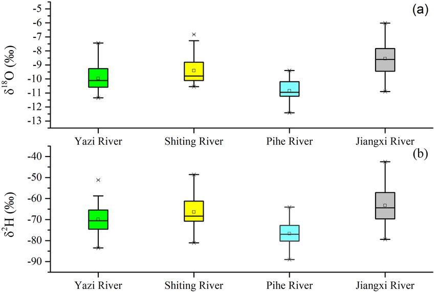
www.nature.com/scientificreports/
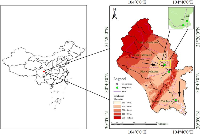
Figure 1. Map of the Tuojiang River catchment and its four sub-catchments, showing the location of the study
area and the sampling site. S1, Y1, P1 and J1 are river water samples site and its elevations are 425 m for S1,
447 m for Y1, 440 m for P1 and 382 m for J1 respectively. The pentacle is the site for sampling precipitation
(489 m). The source of the DEM based on is the open source data of the geospatial data cloud (http://www.gsclo
ud.cn/sources/accessdata/305?pid=302) of which the spatial resolution is 90 m. This map was extracted and
generated using ARCGIS (Version 10.2).
many studies are interested in estimating MRT for characterizing the catchment. Most of them focus on small
catchments because of the difficulty that exists in field sampling and observation. Describing hydrological pro-
cesses for large-scale catchments is important. Because it is necessary for developing a more conceptual model
and be used to address questions at scale that impact land management and climate change7. Therefore, how to
extend those results from a single small catchment to a large-catchment scale is a vital problem. The relation-
ship between stream residence time and landscape feature provides an opportunity to resolve it. Rodgers et al.1,
McGlynn et al.8 have proved that the residence time of water in the catchment is independent of the catchment
scale. However, Farrick and B ranfireun17 have found a strong negative relationship between the catchment area
and MRT. Different results above may suggest that the topography or catchment area is not the only factor gov-
erning residence time distributions. In steep hillslope, the topography may mask the effect of the catchment area.
Therefore, studies in the plain region with moderate terrain may help us to figure out how the catchment scale
influences MRT. However, previous studies in plain referred to MRT focus on using MRT as a tool to investigate
catchment hydrology rather than studying the relationship between MRT and catchment scale20,21. For exam-
ple, Cao et al.22 estimated the MRT of groundwater in the Yang-Dai River plain to identify pollution status and
groundwater cyclical pattern. Ben Ammar et al.23 carried out isotopic (18O, 2H and 3H) investigation to assesses
groundwater renewability by estimate the residence time of groundwater in the plain of Wadi Guenniche. Ma
and Yamanaka24 estimated time-variant MTTs for about ten years (2003–2012) in five mesoscale sub-catchments
of the Fuji River catchment, central Japan and found long-term average MTT was principally controlled by the
amount of groundwater storage, especially in the plain region.
In this paper, the four tributaries of the upper Tuojiang river in Chengdu plain was selected for its slight
topography and relatively uniform climatic condition. We conducted a 1-year sampling and isotope measure-
ment of the water from the four sub-catchments within the Tuojiang River catchment to analyze the periodicity
of its isotope changes. Then, MRT values are estimated for the four sub-catchments, respectively. This paper aims
to: (1) compare the MRT differences in the four sub-catchments of the upper Tuojiang River based on stable
isotope data; (2) identify the correlation between the catchment parameters and MRT; and (3) determine the
dominantly influencing factors of the MRT.
Study area
The Chengdu Plain is located in the west of the Sichuan Basin and surrounded by Longquan and Longmen
mountains. As an alluvial plain in southwest China, it has an extensive area and its terrain is high in the west
and low in the east with a low elevation. Tuojiang River is an upstream tributary of the Yangtze River and is an
economically and ecologically important river passing through the hinterland of the Sichuan Basin (Fig. 1). It
Scientific Reports | (2021) 11:2812 | https://doi.org/10.1038/s41598-021-82349-3 2
Vol:.(1234567890)www.nature.com/scientificreports/
Catchment Area (km2) Mean slope (°) Mean topographic index Sand clay loam (%)
Yazi River 1329.24 14.03 8.26 46.90
Shiting River 1531.17 13.44 8.40 42.83
Pihe River 2168.55 2.21 10.58 78.17
Jiangxi River 907.12 6.39 8.05 22.17
Table 1. Topographic characteristics of the four sub-catchments within Tuojiang River catchment.
Catchment Resident and industrial area (%) Forest land (%) Cultivated land (%) Paddy field (%) Dry land (%)
Yazi River 5.21 37.13 47.47 38.44 9.03
Shiting River 6.41 33.99 49.28 41.34 7.94
Pihe River 17.96 9.42 70.86 63.96 9.68
Jiangxi River 1.65 16.52 79.07 32.30 46.77
Table 2. Statistics of the land use at four sub-catchments within Tuojiang River catchment.
originates from Jiuding mountain in Mianzhu City and flows through the Chengdu Plain with a total length of
712 km and a drainage area of 32,900 km225. The climate of Tuojiang River catchment is subtropical monsoon
climate, with an annual average temperature of 17.1 °C, an annual average flow of 35.1 × 10⁸ m3 and average
precipitation of 1050 mm. There are distinct dry and wet season with 65–75% of the total annual precipitation
falls from June to September in the Tuojiang River catchment26. The Tuojiang River spans across several different
terrains such as plain, hill and mountains and the plain are located along both sides of the Tuojiang River. This
study focuses on four sub-catchments within Tuojiang River catchment (104°E–105.5°E, 29°N–31.5°N), named
Shiting River catchment, Yazi River catchment, Pihe River catchment and Jiangxi River catchment respectively.
Both Shiting River and Yazi River receive precipitation from 900 to 1500 mm annually, while the Pihe River and
Jiangxi River receive only 870 mm. The four sub-catchments area range from 907.12 to 2168.55 k m2 (Table 1).
The Pihe River catchment, which is the largest catchment of these sub-catchments, is the lowest slope and paddy-
dominated region (account for 63.96% of its total area) (Table 2). Pihe River originates from the Min River and
flows into the Tuojiang River after merging with the Qingbai River. It connects the Min River system with the
Tuojiang River s ystem27. Slopes in the uppermost part of the Tuojiang River catchment (Shiting River catchment
and Yazi River catchment) tend to be steep (13.44° to 14.03°) and slopes in the middle part of the Tuojiang River
catchment (Pihe River catchment and Jiangxi River catchment) appear to be much gentler (2.21° to 3.39°). The
Shiting River catchment and Yazi River catchment locate within the transition region between the Longmen
mountain and the Chengdu plain, with the forest coverage range from 37.13 to 33.99%. The Jiangxi River is the
first-grade tributary of the Tuojiang River. It originates from the Longquan Mountains and joins the Tuojiang
River in Jianyang city. It is a typical seasonal river which is mainly recharged by rainfall and its water volume is
quite small in the dry season.
Perudic Argosols (PA), Stagnic Anthrosols (SA), Dystric Purpli-Udic Cambosols (DPC), Typic Purpli-Udic
Cambosols (TPC), Calcific Purpli-Udic Cambosols (CPC) and, Ochri-Aquic Cambosol (OC) are widely dis-
tributed on the study region. Tuojiang River flows through a densely populated region where various land types
exist, including arid land, paddy field, orchard, forestland, grassland and shrub land28. The agricultural land is
mainly distributed on the side of the mainstream of the Tuojiang river and the forestland is mainly distributed
on the Mountain.
Methods and materials
Sampling and isotope analysis. A total of 113 precipitation samples were collected from May 2018 to
April 2019 in bulk collectors in the test field of Sichuan University (104.08°E, 30.63°N) where the shortest dis-
tance from the Tuojiang River is 38 km. Precipitation samplers consist of plastic funnels that are attached to
plastic bottles and a ball that is placed in the center of the funnel to minimize evaporation. Precipitation samples
were immediately collected after every rainfall event to reduce the impact on evaporation to the minimum.
The source of soil data comes from the Harmonized World Soil Database (HWSD) constructed by the Food
and Agriculture Organization of the United Nations (FAO) and the International Institute for Applied Systems
(IIASA) on 2009. The soil data resolution is 1 km2. The source of land use data comes from the Resource and
Environment Science and Data Center of the Institute of Geographic Sciences and Resources Research, Chinese
Academy of Sciences on 2015. The resolution of land use data is 1 km2.
A total of 116 river water samples were collected at the outlet section of four sub-catchments from May 2018
to April 2019. River water samples were hand-dipped along the river shore at a water depth below 20 cm where
relatively clean and flowing water was presented. These water samples were stored in a 20 ml vial of the clean
high-density polyethylene bottle with a tight screw cap and the water samples were quickly stored in the refrigera-
tor. The river water samples were collected weekly during the wet season (May–October), while bi-weekly during
the dry season (November–April). The number of samples per month may vary slightly due to unfavourable
weather conditions and human factors. The isotopic composition (δ18O and δ2H) of the samples were determined
Scientific Reports | (2021) 11:2812 | https://doi.org/10.1038/s41598-021-82349-3 3
Vol.:(0123456789)www.nature.com/scientificreports/
at the Sichuan University laboratory, using a triple-liquid water isotope analyzer which is manufactured by Los
Gatos Research (LGR). The LGR analyzer uses spectrometry to measure the stable isotope content of water and
its measurement principle is the OFF-AXIS Integrated Cavity Output Spectrometer (OA-ICOS). With the aid
of a fully automatic sampler, the analyzer continuously measures the sample according to a computer program
and filters the sample impurities by using a 0.45 μm filter before measurement. Each sample was measured six
times, the first two measurements were discarded due to their large error and only the average of the last four
measurements was taken. Reference standard samples based on VSOMW-2 and SLAP-2 were measured at inter-
vals of three water samples to diagnose whether an abnormality occurred during the measurement. The stable
hydrogen and oxygen isotope values in the water sample are expressed by the thousandth deviation from the
Vienna standard average seawater V-SMOW, which is defined as follows:
(1)
δ(‰) = Rsample − Rstandard /(Rstandard ) × 100
where Rsample and Rstandard represent the value of 18O/16O and 2H/1H in the samples and the standard samples
respectively. The measurement error of the instrument is δ2H < 0.3‰, δ18O < 0.08‰.
Theoretical methods. The isotope composition of river water response to the isotope composition of pre-
cipitation that falls on catchment need some time before reaching the river. The seasonal variability is reflected in
stable isotope values of precipitation and is often inherited by river water. The river outflows composition at any
time, δout (t), consisting of past inputs lagged, δin (t − τ), according to their residence time distribution, g(τ)29,30:
∞
δout = g(τ)δin (t − τ)dτ (2)
0
where τ is the lag times between input and output tracer composition. Equation (2) is similar to the linear sys-
tems approach used in unit hydrograph models (Dooge, 1973). In this paper, only isotope tracer is considered,
therefore the transfer function is represented by g(τ). The approach mentioned above (Eq. (2)) is valid only in
the circumstance of a steady system and a stable mean flow pattern31. The residence time distribution (ie. g(τ))
characterizes the fractional weighting of how isotope tracer exits the catchment. The MRT of tracer is equal to
the MRT of water because we use the stable isotopes like 2H and 18O which are conservative as tracer7. Residence
time distribution in catchment is selected by the exact nature of its flow path distribution and flow system. Three
main model types, including dispersion model (DM), the exponential model (EM) and the exponential-piston
flow model (EPM), have been used frequently in catchment systems8,19,32–34. The exponential model that has been
proved valid in many catchments35,36 is employed in the study. The exponential model is defined by following
the g(τ) function10:
g(τ) = T−1 exp(τ/T) (3)
where T is the residence time.
In the middle latitude region, the stable isotopic compositions of precipitation have a strong seasonal change,
especially in the monsoon climate zone like the southwest of China. Seasonal trends in δ18 O value are modelled
through periodic regression analysis to fit seasonal sine wave curves to annual δ18 O value variations of the pre-
ater1,18,32 defined as:
cipitation and river w
δ18 O=X+A[cos(ct − θ)] (4)
18 18 18
where δ O refers to the simulated δ O, X refers to the annual average of the measured δ O value, A for the
annual amplitude of the measured value δ18O, c for the annual fluctuation of the radial frequency (0.017214 rad
d−1), and t is the number of days between the sampling time and the starting time (2018/5/6), θ refers to the
phase lag or time at which δ18O peaks.
The MRT is estimated via the commonly used exponential model in which precipitation inputs are assumed
to mix rapidly with resident water, by the following equation:
0.5
MRT = c−1 [(AZ2 /AZ1 )−2 −1] (5)
In this equation, A
Z1 is the amplitude of rainfall, A
Z2 is the amplitude of the river water, and c is the radial
frequency of the annual amplitude of Eq. (4).
Results and discussion
Stable isotope variation of rivers water. The measured δ18O and δ2H values of river water collected
from outlets of four tributaries (Yazi, Shiting, Pihe and Jiangxi River) range from − 12.4 to − 8.6‰ and − 89 to
− 63.3‰, respectively (Fig. 2). The δ18O values of Pihe River waters range from − 12.4 to − 9.4‰ and δ2H values
range from − 89 to − 64‰. The lowest average δ18O and δ2H values and the lowest standard deviation relative
to the other three rivers are observed in the Pihe River water. The average δ18O and δ2H values of Yazi River are
− 9.96‰ and − 69.8‰ respectively which are close to that of Shiting River. The average δ18O and δ2H values
of these two rivers are in general higher than that of the Pihe River and lower than that of Jiangxi River, with a
medium standard deviation. The river water from the Yazi River and Shiting River contains a relatively medium
magnitude of variations in δ18O and δ2H, with δ18O ranging from − 11.3 to − 7.4‰ and − 10.6 to − 6.8‰ and
δ2H from − 83.4 to − 51.2‰ and − 81 to − 48.6‰ respectively. The highest δ18O and δ2H values are observed in
Scientific Reports | (2021) 11:2812 | https://doi.org/10.1038/s41598-021-82349-3 4
Vol:.(1234567890)www.nature.com/scientificreports/
Figure 2. Box plots of spatial variation for δ18O (a) and δ2H (b) among Yazi River, Shiting River Pihe River and
Jiangxi River. The box plot has lines at the lower quartile, median, and upper quartile values. The whiskers of the
box are lines extending from each end of the box to show the extent of the rest of the data. The outliers of the
box are data with values beyond the ends of the whiskers.
the Jiangxi River, with δ18O ranging from − 10.9 to − 6.0‰ and δ2H from − 79.4 to 42.5‰. The standard devia-
tion of δ18O and δ2H values in Jiangxi River is high as it reaches 1.14‰ and 8.97‰ respectively.
The lowest isotopic composition of the Pihe River shows a different water source between Pihe River and
the other three tributaries. Pihe River receives the water from the Min River where the isotopic composition of
surface water proved d epleted37. The river water is generally a mixture of channel precipitation, overland flow,
subsurface baseflow, agricultural drains and even municipal effluents and its isotope values could be viewed as
the average level of the comprehensive characteristics of the catchment as well as the reflection of the climate
condition. The close isotope values of the Yazi River and Shiting River indicate the similar characteristics of the
catchment and climate condition. Except for the Pihe River, another three Rivers’ isotope value increase with
the latitude and elevation, which could be attributed to the precipitation’s latitude effect that causes the depleted
isotope values in precipitation. Jiangxi River is a seasonal river heavily affected by precipitation. Hence, the
δ18O and δ2H values of Jiangxi River water are also affected by the high δ18O and δ2H values of precipitation.
Moreover, the construction of reservoirs in Jiangxi River increases its water evaporation phenomena and results
in its enriched isotope v alues38.
Characteristics of the river water line (RWL) among four sub‑catchments. Based on the sta-
ble isotope data measured on water samples collected from four tributaries, we calculate the δ18O versus δ2H
relationship (i.e. river water line) of the four rivers (Fig. 3). The slopes of the RWL for the Yazi River, Shiting
River, Pihe River and Jiangxi River range from 4.85 to 6.36. Compared to the slope of the local meteoric water
line (LMWL) of 7.61 in the study area, the slope and intercept of the RWL of four tributaries are low39. What’s
more, compared with the slope of RWL in adjoining areas, such as the Hailuogou River and the Heishui River in
Sichuan Basin, the slopes of RWL in the four sub-catchments are still low37,40. The lower slopes of the four RWL
indicate that the precipitation occurs evaporation before reaching the river. The stable isotope in the precipita-
tion undergoes kinetic fractionation which makes different fractionation factors between δ2H and δ18O, then
eventually leads to the decrease of the slope of RWL. The lowest slope of RWL is observed in the Pihe River and it
could be attributed to the high evaporation of the Pihe River water. The evaporation ratio of the Pihe River water,
according to previous studies, ranging from 0.48 to 10.22%. There are seasonal differences in evaporation, water
evaporates significantly in the rainy season under the influence of high t emperature27. The slopes of RWL of the
other three rivers are much larger than those of the Pihe River. Spatial heterogeneity of physio-geographical
components leads to spatial and temporal changes of the hydrological process in the catchment. The different
slopes of RWL between four tributaries of the Tuojiang River reflect the characteristics of each catchment. The
largest area and lowest slope of Pihe River catchment may slow down the rate that precipitation flows into the
river, resulting in the long residence time and greater evaporation of the water in the Pihe River catchment. Thus,
make the slope of the RWL of the Pihe River smaller than the other three rivers. The difference of isotope value
and slope of the RWL among four catchments reflect different hydrologic features of four sub-catchments. It also
proves that the stable isotope could be used as a tracer to investigate the characteristics of the catchment and
enhance our understanding of the hydrological process in the catchment.
Scientific Reports | (2021) 11:2812 | https://doi.org/10.1038/s41598-021-82349-3 5
Vol.:(0123456789)www.nature.com/scientificreports/
Figure 3. RWL of four tributaries of the Tuojiang River (Yazi River (a), Shiting River (b), Pihe River (c), Jiangxi
River (d)).
Seasonal analysis of δ18O patterns and estimates of MRT among four sub‑catchments. The
four sub-catchments are located in southwest China where belongs to the subtropical monsoon climate zone. It
is controlled by the East Asian monsoon, the Indian monsoon, and the northwest monsoon. Therefore, signifi-
cant seasonal δ18O trends in precipitation and river water are observed here (Fig. 4). Previous studies prove that
the sine-wave approach could be used to estimate MRT by using a lumped parameter model that takes advan-
tage of the strong seasonal changes in the isotopic composition of precipitation41,42. The seasonal δ18O trends of
precipitation and river water could be interpreted quantitatively by using periodic regression analyses (Eq. (4))
(Fig. 4). Although the modelled curves simplify the pattern of isotopic changes in precipitation and river water,
the results are all nonetheless statistically robust (p < 0.02). The correlation between measured and modelled
δ18O in precipitation and river water is relatively strong, with r2 = 0.54, 0.53, 0.43, 0.26, 0.32 for precipitation, Yazi
River, Shiting River, Pihe River and Jiangxi River respectively. These results are comparable with other similar
studies18,43. The lowest amplitude and relatively weak r2 of 0.26 are observed in the Pihe River and it could be
attributed to the existence of Pihe Water Supply Project. The incoming water of the Pihe Water Supply Project
is dispatched by the Zipingpu Reservoir to meet the water consumption of the Dujiangyan Irrigation District.
Then the remaining water is supplied to the Pihe River catchment. During this process, the seasonal change of
the isotope value of river water is disturbed by human activities. Modelled δ18O values for the Yazi River, Shiting
River, Jiangxi River fit better with measured values and show larger δ18O amplitude values, ranging from 0.86 to
0.92 (Table 3). Combined with a large amplitude, these significant seasonal variations in δ18O of the Yazi River,
Shiting River and Jiangxi River reflect greater responsiveness to recent precipitation inputs. The δ18O amplitude
of precipitation (A = 5.58) during 2018–2019 is similar to the δ18O amplitude of precipitation during 1996–1997
in Chengdu. The amplitude of the sine curves can be used to estimate catchment MRT by Eq. (5). Shorter MRTs
(346 to 374 days) are observed in the Yazi River catchment, Shiting River catchment and Jiangxi River catchment
While longer MRT (493 days) is observed in the Pihe River catchment. According to Fenicia et al.44, the tradi-
tional convolution-based mixing model based on steady-state flow assumption affect the estimation of MRT
for high temporal resolution simulations (e.g. hourly). But, this assumption still provides insight for estimat-
ing MRT by using long-term averaged data (e.g. monthly)44. For example, O grinc18 estimated the MRT of the
Sava River catchment by using monthly isotope data. The result shows a longer MRT (2.2 years) than our study
Scientific Reports | (2021) 11:2812 | https://doi.org/10.1038/s41598-021-82349-3 6
Vol:.(1234567890)www.nature.com/scientificreports/
Figure 4. Fitted annual regression models to δ18O for precipitation (e) and river water (a–d) during 2018–2019.
(f) is the fitted annual regression models to δ18O for precipitation at Chengdu City during 1996–1997.
Name MRT (days) Amplitude (%) N R2 RMSE P-value
Yazi 348 0.92 30 0.53 0.61 0
Shiting 375 0.86 29 0.43 0.67 0
Pihe 493 0.65 28 0.26 0.67 0
Jiangxi 346 0.92 29 0.32 0.91 0
Precipitation 5.58 113 0.54 3.06 0
Table 3. Residence times (days) estimated from regression analysis for isotope data of precipitation and river
water. N is the number of water samples. RMSE is the root mean square error of regression.
region. The seasonal variation of stable isotope oxygen-18 is also used to estimate MRT in central Pennsylvania.
MRTs obtained for river water were 9.5 and 4.8 months which is short compare to the result of our s tudy45.
Relationship between topography, soil and MRT. A 90 m digital elevation model (DEM) is used
to compute topographic attributes for 4 sub-catchments in the Tuojiang River catchment. The relationships
between topography, soil and estimated residence time are examined in a formal manner by correlation analysis
(Fig. 5). Regression equations for mean slope (MS), sub-catchments area (SCA), mean topographic index (MTI)
and sandy clay loam ratio (SCL) are shown in Eqs. (6), (7), (8) and (9), respectively.
MRT = −8.84MS + 470(R2 = 0.29) (6)
MRT = 0.123SCA + 207.82(R2 = 0.79) (7)
MRT = 58.6MTI − 126.88(R2 = 0.98) (8)
MRT = 2.72SCL + 260.83(R2 = 0.72) (9)
The relatively weak negative correlation between the mean slope of sub-catchments and MRT is observed
in this region ( r2 = 0.29). The negative relationship between slope and MRT is consistence with our expectation
with the increase of gravitational potential. This negative correlation has also been observed in other regions,
Scientific Reports | (2021) 11:2812 | https://doi.org/10.1038/s41598-021-82349-3 7
Vol.:(0123456789)www.nature.com/scientificreports/
Figure 5. Relationships between mean slope (a), sub-catchment area (b), mean topographic index (c), sandy
clay loam ratio (d) and MRT.
for example, in Zapotlán catchments ( r2 = 0.91)17. A relatively weak correlation between slope and MRT could
be attributed to the gentle terrain in the study region. In some studies, the positive relationships between slope
and MRT are also found, for example, in Feugh catchment (r2 = 0.67) and Feshie catchment (r2 = 0.48)41,43. This
positive relationship between slope and MRT in the Feugh catchment and Feshie catchment may be influenced
by the most responsive peat soils on the flatter hilltops and the steeper slopes. So, the weak correlation between
slope and MRT in our study area may also be disturbed by another factor. In our study, the sub-catchments area
shows an apparently positive relationship to the estimated MRT ( r2 = 0.79). This result is consistent with some
previous studies32,46. However, a weak relationship between catchment area and MRT is also observed in other
studies7,8. These two different results are likely because of other features on MRT of the catchment that offset the
effect of the area. Most of the strong relationships between catchment area and MRT are observed in a catchment
with gentle s lope32 while most weak relationships between catchment area and MRT are observed in a catchment
with steep s lope8,43. This preliminary finding indicates that the area of the catchments may play a major role in
controlling MRT in the plain with gentle terrain. While in the mountainous region with steep terrain, the slope
of the catchment may play a major role in controlling MRT.
In order to find more effective topographic factors that affect MRT, another topographic attribute, topographic
index (i.e., ln(a/tanβ)), is computed by the geographic information system (GIS). Where a is upslope accumu-
lated area and β is the local slope angle47,48. The strongest positive relationship between topographic index and
MRT is observed here ( r2 = 0.98). The similar strong correlations between MRT and topographic index have
also been found in other studies17. The mean value of topographic index does not vary significantly among Yazi,
Shitingjiang and Jiangxi River catchments (from 8 to 8.4). The highest value of topographic index, observed in
Pihe River catchment, is 10.6 (Table 1). The topographic index ln(a/ tan β) is an important component of many
physically based geomorphic and hydrologic models as it reflects the spatial distribution of soil moisture, surface
saturation and runoff generation p rocesses47. For catchment in humid areas like our study region, the runoff is
dominated by stored-full runoff, and the runoff is mainly generated in regions where the soil moisture reaches
above the field capacity—contributing areas. Previous studies19,49,50 suggest that MRT is positively correlate with
the contributing area. With the increase of contributing areas and the decrease in slopes, the topographic index
will increase too. So, as the topographic index increases, its MRT will also increase.
Soil is an important part of catchment hydrology and its physical properties like moisture retention, dis-
tribution of pore space and specific water capacity have an important influence on the catchment’s response
to precipitation. These physical properties are related to the texture of the soil. In some regions like glaciated
Scientific Reports | (2021) 11:2812 | https://doi.org/10.1038/s41598-021-82349-3 8
Vol:.(1234567890)www.nature.com/scientificreports/
Figure 6. Relationships between resident and industrial area ratio (a), forest land ratio (b), cultivated land ratio
(c), paddy field ratio (d), dry land ratio (e) and MRT.
mountains, soil hydrology can also be a useful predictor of MRT due to the fact that its complex drift distribu-
tions may over-ride topographic and geological d ifferences1. Therefore, the sand clay loam ratio is calculated in
the four sub-catchments to investigate the possible relationship to MRT. The results show that the proportion of
sandy clay loam has a relatively strong positive relationship with MRT ( r2 = 0.72). Sandy clay loam in the study
region has a certain number of large pores and a considerable number of capillary pores. So, it has good ventila-
tion, water permeability and good water retention performance and it is mostly used for agricultural cultivation.
Its good water permeability increases the vertical movement of water and the flow path length, resulting in long
MRT. Also, its good water holding capacity slows the catchment response to the precipitation, which increases
its MRT. The longer the retained water in the soil, the stronger its evaporation, which results in the enrichment
of its isotope value in water51. This phenomenon is also found in river water in the study region and the slope of
its RWL gradually decreases with the increase of MRT. The influence of topographic factors on MRT has been
confirmed in many a rticles36,41. Most of them believe that some descriptions of topography provide a first-order
control on flow processes and transport. The influence of topography on MRT has also been verified in this
study. However, in the plain region where the topographical relief is not significant, the catchment area has a
greater impact on the MRT than the catchment slope. Therefore, when we establish the MRT model, we should
pay attention to the influence of the area factor on MRT in the plain region. In addition, our research shows that
the topographic index is very closely related to MRT, which indicates that the topographic index is a reliable
indicator for MRT simulation.
Preliminarily exploration of the relationship between land use type and residence time. Land
use types are closely related to groundwater and runoff processes in the catchment and are susceptible to human
activities52. Additionally, the residence time can be used as a proxy to understand the hydrologic sensitivity
to land use7. As discussed above, the catchment area has a relatively strong relationship with MRT. Here, the
catchment area is classified according to land use type to explore Which land types impose a greater impact
on MRT. In the four sub-catchments of the study region, the river network is densely covered and the terrain
is relatively flat. The four tributaries of the Tuojiang River pass through many towns and agricultural irrigation
regions, which are affected greatly by human activities. The land use types in the study region include forest land,
resident and industrial area, water area, grassland, and cultivated land. The cultivated land includes paddy fields
and dry land. In this study, the ratios of resident and industrial area (RI), forest land (FL), cultivated land (CL),
paddy field (PF) and dry land (DL) versus total sub-catchment area are calculated to explore the potential rela-
tionship between land use type and MRT (Fig. 6). The results are divided into three categories including strong
Scientific Reports | (2021) 11:2812 | https://doi.org/10.1038/s41598-021-82349-3 9
Vol.:(0123456789)www.nature.com/scientificreports/
correlation, weak correlation and non-correlation. Strong positive correlations are observed between paddy field
ratio, resident and industrial area ratio and MRT ( r2 > 0.9). A positive relationship is observed between MRT
and resident and industrial area ratio though it is counter-intuitive; increased resident and industrial area ratio
would lead to decreasing MRT. Increases in the resident and industrial area ratio leads to a large proportion
of impervious areas and the infiltration from the ground surface is close to zero. Stored-full runoff and slope
runoff occur relatively quickly. Precipitation fills every depression and surface runoff formed quickly, resulting
in a fast response to the rainfall in relevant catchments53. However, high resident and industrial area ratios of
four sub-catchments generally have a more paddy field ratio. Moreover, resident and industrial area ratios are
very small in four sub-catchments, which has a limited impact on the hydrological condition of the entire catch-
ment (Table 2). Therefore, the impact of the paddy field ratio on MRT may mask the impact of the resident and
industrial area ratio on MRT. As a result, the relationship between MRT and the resident and industrial area ratio
shows a trend that contradicts our expectation. Four sub-catchments are described as major grain-producing
regions in Sichuan Province. Paddy field accounts for a large proportion, ranging from 32.3 to 64% in four sub-
catchments. The impact of paddy fields on the MRT mainly includes two parts, one is the interception and evap-
oration of precipitation by planting plants, and another one is the soil affecting the infiltration and confluence of
precipitation. Paddy fields in the study region are mainly planted with rice that its transpiration and interception
evaporation is significant. The paddy soil in the study area is mainly sandy clay loam, which has good water
retention performance. Therefore, as the proportion of paddy fields in the catchment increases, its MRT grows
higher. A weak negative correlation is observed between forest land ratio and MRT ( r2 = 0.18) (Fig. 6). This may
be attributed to the low vegetation coverage of the Tuojiang River catchment and its soil properties in forest
land. For example, among the four sub-catchments, the forest coverage of the Shiting River catchment and Yazi
River catchment is relatively large, ranging from 33.99 to 37.13% (Table 2). Its soil porosity in forest land is large
and has strong permeability, but its water retention is poor, which causes the shorter MRT. Non-correlations
are observed between cultivated land ratio, dry land ratio and MRT ( r2 < 0). The results do not conform to our
expectation as the study area is a plain region with advanced agriculture and a large ratio of cultivated land area.
These results show that in regions dominated by irrigated agriculture, MRT is closely relate to the ratio of paddy
field area compared to the total cultivated land area ratio or dry land area ratio. These results also illustrate that
in future research on the MRT model, we should pay attention to the influence of the paddy field on the MRT
in catchments dominated by agricultural irrigation. MRT plays an important role in controlling the quality of
water that drains soil or c atchments45. With the advancement of urbanization, many paddy fields have been
changed to urban land, which will undoubtedly cause shorter MRT, thereby leads to serious pollution in the
catchment. As the hydrological investigation on the catchment scale is very difficult, we only conducted a long-
term isotope monitoring on four sub-catchments. The scarcity of sampling sites might result in accidental errors.
For example, the r2 for cultivated land ratio and dry land are − 0.37 and − 0.26 respectively, which is impossible.
It suggested that a small catchment with more sub-catchments in the future research should be selected. More
sub-catchments would allow the study to obtain more samples to increase the representativeness of the study. A
small catchment is conducive to long-term sampling and reduce the impact of spatial heterogeneity on the MRT.
Nevertheless, as an initial attempt to simulate MRT in catchments, this paper provides profound insights and
experience for the study in this field.
Conclusion
In this paper, characteristics of RWL and variations of stable isotope in river water among four sub-catchments
in Tuojiang River catchment are investigated. The result shows that Pihe River has depleted isotope value and
the lowest slope of RWL. It also indicated different sources between the Pihe River and the other three rivers
as well as high evaporation of the Pihe River, which is generally consistent with the long mean residence time.
The sine-wave approach is used to model the season trends in δ18O and the amplitude of seasonal δ18O curves
in river water is used to estimate the MRT. Modelled δ18O value compares well to measured δ18O value in river
water from different locations within the Tuojiang River catchments. Estimated MRT within four sub-catchments
ranges from 346 to 493 days and the longest residence time is observed in Pihe River catchment. Moreover,
potential relationships between topography, catchment area, soil, land use and MRT are investigated in this
paper. The results show that the topographic feature is a main affecting factor of MRT, while the influence of
topographic factors on the correlation between slope and MRT in the plain region is relatively weak. A relatively
strong positive relationship between catchment area and MRT is observed in the study region which suggests
that the catchment area may have a greater impact on the MRT than the slope in plain region. We should pay
more attention to this in the future MRT simulation of the catchment in the plain region. In addition, the soil
type is also an important parameter in simulating catchment MRT. Compared with other factors, the topographic
index may be a reliable parameter to estimate the MRT of the catchment as its strongest correlation between
topographic index and MRT. By comparing the correlation between land use types and MRT, we find that in
plain region with developed agricultural irrigation, the proportion of paddy fields in the catchment has a great
impact on MRT. Results from this study could reveal several catchment characteristic parameters related to MRT,
which will provide some reference for future MRT models and improve our understanding of hydrological and
hydro-chemical processes in the catchment (Supplementary Information).
Data availability
The dataset is provided by National Cryosphere Desert Data Center (http://www.ncdc.ac.cn).
Received: 22 August 2020; Accepted: 19 January 2021
Scientific Reports | (2021) 11:2812 | https://doi.org/10.1038/s41598-021-82349-3 10
Vol:.(1234567890)www.nature.com/scientificreports/
References
1. Rodgers, P., Soulsby, C. & Waldron, S. Stable isotope tracers as diagnostic tools in upscaling flow path understanding and residence
time estimates in a mountainous mesoscale catchment. Hydrol. Process. 19, 2291–2307. https://doi.org/10.1002/hyp.5677 (2005).
2. Uhlenbrook, S., Frey, M., Leibundgut, C. & Maloszewski, P. Hydrograph separations in a mesoscale mountainous basin at event
and seasonal timescales. Water Resour. Res. 38, 31-1-31–14. https://doi.org/10.1029/2001wr000938 (2002).
3. Marchina, C. et al. The Po river water from the Alps to the Adriatic Sea (Italy): New insights from geochemical and isotopic
(delta(18)O-deltaD) data. Environ. Sci. Pollut. Res. Int. 22, 5184–5203. https://doi.org/10.1007/s11356-014-3750-6 (2015).
4. Zuecco, G. et al. Understanding hydrological processes in glacierized catchments: Evidence and implications of highly-variable
isotopic and electrical conductivity data. Hydrol. Process. https://doi.org/10.1002/hyp.13366 (2018).
5. Wan, C. et al. Integrating isotope mass balance and water residence time dating: Insights of runoff generation in small permafrost
watersheds from stable and radioactive isotopes. J. Radioanal. Nucl. Chem. 326, 241–254. https://doi.org/10.1007/s10967-020-
07315-1 (2020).
6. McGuire, K. J. & McDonnell, J. J. A review and evaluation of catchment transit time modeling. J. Hydrol. 330, 543–563. https://
doi.org/10.1016/j.jhydrol.2006.04.020 (2006).
7. McGuire, K. J. et al. The role of topography on catchment-scale water residence time. Water Resour. Res. https://doi.
org/10.1029/2004wr003657 (2005).
8. McGlynn, B., McDonnell, J., Stewart, M. & Seibert, J. On the relationships between catchment scale and streamwater mean residence
time. Hydrol. Process. 17, 175–181. https://doi.org/10.1002/hyp.5085 (2003).
9. Ogrinc, N., Kanduč, T., Stichler, W. & Vreča, P. Spatial and seasonal variations in δ18O and δD values in the River Sava in Slovenia.
J. Hydrol. 359, 303–312. https://doi.org/10.1016/j.jhydrol.2008.07.010 (2008).
10. Maloszewski, P., Rauert, W., Stichler, W. & Herrmann, A. Application of flow models in an Alpine catchment-area using tritium
and deuterium data. J. Hydrol. 66, 319–330. https://doi.org/10.1016/0022-1694(83)90193-2 (1983).
11. Burns, D. A. et al. The geochemical evolution of riparian ground water in a forested piedmont catchment. Ground Water 41,
913–925. https://doi.org/10.1111/j.1745-6584.2003.tb02434.x (2003).
12. Landon, M. K., Delin, G. N., Komor, S. C. & Regan, C. P. Relation of pathways and transit times of recharge water to nitrate con-
centrations using stable isotopes. Ground Water 38, 381–395. https://doi.org/10.1111/j.1745-6584.2000.tb00224.x (2000).
13. Turner, J. et al. Future trends in transport and fate of diffuse contaminants in catchments, with special emphasis on stable isotope
applications. Hydrol. Process. 20, 205–213. https://doi.org/10.1002/hyp.6074 (2006).
14. Mcdonnell, J. J., Stewart, M. K. & Owens, I. F. Effect of catchment-scale subsurface mixing on stream isotopic response. Water
Resour. Res. 27, 3065–3073. https://doi.org/10.1029/91wr02025 (1991).
15. Kirchner, J. W., Feng, X. H. & Neal, C. Catchment-scale advection and dispersion as a mechanism for fractal scaling in stream
tracer concentrations. J. Hydrol. 254, 82–101. https://doi.org/10.1016/S0022-1694(01)00487-5 (2001).
16. Niinikoski, P. I., Hendriksson, N. M. & Karhu, J. A. Using stable isotopes to resolve transit times and travel routes of river water:
A case study from southern Finland. Isotopes Environ. Health Stud. 52, 380–392. https://doi.org/10.1080/10256016.2015.1107553
(2016).
17. Farrick, K. K. & Branfireun, B. A. Flowpaths, source water contributions and water residence times in a Mexican tropical dry forest
catchment. J. Hydrol. 529, 854–865. https://doi.org/10.1016/j.jhydrol.2015.08.059 (2015).
18. Ogrinc, N. et al. Distribution of H and O stable isotopes in the surface waters of the Sava River, the major tributary of the Danube
River. J. Hydrol. 565, 365–373. https://doi.org/10.1016/j.jhydrol.2018.08.024 (2018).
19. Stewart, M. K. & Mcdonnell, J. J. Modeling base-flow soil-water residence times from deuterium concentrations. Water Resour.
Res. 27, 2681–2693. https://doi.org/10.1029/91wr01569 (1991).
20. Martínez, D. E. et al. Hydrogeochemistry, isotopic composition and water age in the hydrologic system of a large catchment within
a plain humid environment (Argentine Pampas): Quequén Grande River, Argentina. River Res. Appl. 33, 438–449. https://doi.
org/10.1002/rra.3072 (2017).
21. Bouhlassa, S., Ammary, B. & Elyahyaoui, A. Environmental tritium measurements and lumped parameter modelling in the Tafilalet
aquifer, south-east Morocco. Radiochim. Acta 95, 607. https://doi.org/10.1524/ract.2007.95.10.607 (2007).
22. Cao, T., Han, D., Song, X. & Trolle, D. Subsurface hydrological processes and groundwater residence time in a coastal alluvium
aquifer: Evidence from environmental tracers (delta(18)O, delta(2)H, CFCs, (3)H) combined with hydrochemistry. Sci. Total
Environ. 743, 140684. https://doi.org/10.1016/j.scitotenv.2020.140684 (2020).
23. Ben Ammar, S. et al. Using geochemical and isotopic tracers to characterize groundwater dynamics and salinity sources in the
Wadi Guenniche coastal plain in northern Tunisia. J. Arid Environ. 178, 104150. https://doi.org/10.1016/j.jaridenv.2020.104150
(2020).
24. Ma, W. & Yamanaka, T. Factors controlling inter-catchment variation of mean transit time with consideration of temporal vari-
ability. J. Hydrol. 534, 193–204. https://doi.org/10.1016/j.jhydrol.2015.12.061 (2016).
25. Hu, J. et al. Attribution Analysis of Runoff Change in Min-Tuo River Basin based on SWAT model simulations, China. Sci Rep 10,
2900. https://doi.org/10.1038/s41598-020-59659-z (2020).
26. Yao, L., Xu, J., Zhang, M., Lv, C. & Li, C. Waste load equilibrium allocation: A soft path for coping with deteriorating water systems.
Environ. Sci. Pollut. Res. Int. 23, 14968–14988. https://doi.org/10.1007/s11356-016-6593-5 (2016).
27. Chen, K. et al. Identifying hydrological conditions of the Pihe River catchment in the Chengdu Plain based on spatio-temporal
distribution of 2H and 18O. J. Radioanal. Nucl. Chem. 324, 1125–1140. https://doi.org/10.1007/s10967-020-07163-z (2020).
28. Xu, X. X. et al. Spatial variability characteristics of soil available Mn and Zn in the middle reaches of Tuojiang River Basin. Adv.
Mater. Res. 518–523, 2204–2212. https://doi.org/10.4028/www.scientific.net/AMR.518-523.2204 (2012).
29. Barnes, C. J. & Bonell, M. Application of unit hydrograph techniques to solute transport in catchments. Hydrol. Process. 10, 793–802
(1996).
30. Maloszewski, P. & Zuber, A. Determining the turnover time of groundwater systems with the aid of environmental tracers. 1.
Models and their applicability. J. Hydrol. 57, 207–231 (1982).
31. Zuber, A. On the interpretation of tracer data in variable flow systems. J. Hydrol. 86, 45–57. https://doi.org/10.1016/0022-
1694(86)90005-3 (1986).
32. Dewalle, D. R., Edwards, P. J., Swistock, B. R., Aravena, R. & Drimmie, R. J. Seasonal isotope hydrology of three Appalachian
forest catchments. Hydrol. Process. 11, 1895–1906. https://doi.org/10.1002/(Sici)1099-1085(199712)11:15%3c1895::Aid-Hyp53
8%3e3.0.Co;2-# (1997).
33. Vitvar, T. & Balderer, W. Estimation of mean water residence times and runoff generation by 18O measurements in a pre-Alpine
catchment. Appl. Geochem. 12, 787–796 (1997).
34. Ma, J., Song, W., Wu, J., Liu, Z. & Wei, Z. Identifying the mean residence time of soil water for different vegetation types in a water
source area of the Yuanyang Terrace, southwestern China. Isotopes Environ. Health Stud. 55, 272–289. https: //doi.org/10.1080/10256
016.2019.1601090 (2019).
35. Maloszewski, P. & Zuber, A. A general lumped parameter model for the interpretation of tracer data and transit time calculation
in hydrologic systems—Comments. J. Hydrol. 204, 297–300 (1998).
36. Buttle, J. M. et al. Prediction of groundwater characteristics in forested and harvested basins during spring snowmelt using a
topographic index. Hydrol. Process. 15, 3389–3407. https://doi.org/10.1002/hyp.1033 (2001).
Scientific Reports | (2021) 11:2812 | https://doi.org/10.1038/s41598-021-82349-3 11
Vol.:(0123456789)www.nature.com/scientificreports/
37. Liu, Y. et al. Characteristics of water isotopes and hydrograph separation during the wet season in the Heishui River, China. J.
Hydrol. 353, 314–321. https://doi.org/10.1016/j.jhydrol.2008.02.017 (2008).
38. Xia, C. et al. Revealing the impact of water conservancy projects and urbanization on hydrological cycle based on the distribution
of hydrogen and oxygen isotopes in water. Environ. Sci. Pollut. Res. Int. https://doi.org/10.1007/s11356-020-11647-6 (2020).
39. Xia, C. C. Comparison of precipitation stable isotopes during wet and dry seasons in a subtropical monsoon climate region of
China. Appl. Ecol. Environ. Res. 17, 11979–11993. https://doi.org/10.15666/aeer/1705_1197911993 (2019).
40. Meng, Y. & Liu, G. Stable isotopic information for hydrological investigation in Hailuogou watershed on the eastern slope of Mount
Gongga, China. Environ. Earth Sci. 69, 29–39. https://doi.org/10.1007/s12665-012-1931-5 (2012).
41. Rodgers, P., Soulsby, C., Waldron, S. & Tetzlaff, D. Using stable isotope tracers to assess hydrological flow paths, residence times
and landscape influences in a nested mesoscale catchment. Hydrol. Earth Syst. Sci. 9, 139–155. https://doi.org/10.5194/hess-9-
139-2005 (2005).
42. Soulsby, C. & Tetzlaff, D. Towards simple approaches for mean residence time estimation in ungauged basins using tracers and
soil distributions. J. Hydrol. 363, 60–74. https://doi.org/10.1016/j.jhydrol.2008.10.001 (2008).
43. Soulsby, C., Tetzlaff, D., Rodgers, P., Dunn, S. & Waldron, S. Runoff processes, stream water residence times and controlling
landscape characteristics in a mesoscale catchment: An initial evaluation. J. Hydrol. 325, 197–221. https://doi.org/10.1016/j.jhydr
ol.2005.10.024 (2006).
44. Fenicia, F. et al. Assessing the impact of mixing assumptions on the estimation of streamwater mean residence time. Hydrol. Process.
24, 1730–1741. https://doi.org/10.1002/hyp.7595 (2010).
45. McGuire, K. J., DeWalle, D. R. & Gburek, W. J. Evaluation of mean residence time in subsurface waters using oxygen-18 fluctua-
tions during drought conditions in the mid-Appalachians. J. Hydrol. 261, 132–149. https://doi.org/10.1016/S0022-1694(02)00006
-9 (2002).
46. Soulsby, C., Malcolm, R., Helliwell, R., Ferrier, R. C. & Jenkins, A. Isotope hydrology of the Allt a’Mharcaidh catchment, Cairn-
gorms, Scotland: Implications for hydrological pathways and residence times. Hydrol. Process. 14, 747–762. https: //doi.org/10.1002/
(Sici)1099-1085(200003)14:4%3c747::Aid-Hyp970%3e3.0.Co;2-0 (2000).
47. Zhang, W. H. & Montgomery, D. R. Digital elevation model grid size, landscape representation, and hydrologic simulations. Water
Resour. Res. 30, 1019–1028. https://doi.org/10.1029/93wr03553 (1994).
48. Beven, K. J. & Kirkby, M. J. A physically based, variable contributing area model of basin hydrology/Un modèle à base physique
de zone d’appel variable de l’hydrologie du bassin versant. Hydrol. Sci. Bull. 24, 43–69. https://doi.org/10.1080/026266679094918
34 (1979).
49. Rodhe, A., Nyberg, L. & Bishop, K. Transit times for water in a small till catchment from a step shift in the oxygen 18 content of
the water input. Water Resour. Res. 32, 3497–3511. https://doi.org/10.1029/95wr01806 (1996).
50. McGlynn, B. L. & Seibert, J. Distributed assessment of contributing area and riparian buffering along stream networks. Water
Resour. Res. https://doi.org/10.1029/2002wr001521 (2003).
51. Simin, Q. et al. Evaluating infiltration mechanisms using breakthrough curve and mean residence time. Water Resour. Manag. 27,
4579–4590. https://doi.org/10.1007/s11269-013-0427-8 (2013).
52. Xia, C., Liu, G., Meng, Y., Wang, Z. & Zhang, X. Impact of human activities on urban river system and its implication for water-
environment risks: An isotope-based investigation in Chengdu, China. Hum. Ecol. Risk Assess. Int. J. https: //doi.org/10.1080/10807
039.2020.1848416 (2020).
53. Penna, D. et al. Response time and water origin in a steep nested catchment in the Italian Dolomites. Hydrol. Process. 31, 768–782.
https://doi.org/10.1002/hyp.11050 (2017).
Author contributions
J.Z. conceived the study with the help of C.X. J.Z. and Y.C. C.X., K.C. analysed the data. J.Z. authored the manu-
script with the support and contribution of Y.M., G.L., and all authors approved the manuscript for submission.
Competing interests
The authors declare no competing interests.
Additional information
Supplementary Information The online version contains supplementary material available at https://doi.
org/10.1038/s41598-021-82349-3.
Correspondence and requests for materials should be addressed to Y.M.
Reprints and permissions information is available at www.nature.com/reprints.
Publisher’s note Springer Nature remains neutral with regard to jurisdictional claims in published maps and
institutional affiliations.
Open Access This article is licensed under a Creative Commons Attribution 4.0 International
License, which permits use, sharing, adaptation, distribution and reproduction in any medium or
format, as long as you give appropriate credit to the original author(s) and the source, provide a link to the
Creative Commons licence, and indicate if changes were made. The images or other third party material in this
article are included in the article’s Creative Commons licence, unless indicated otherwise in a credit line to the
material. If material is not included in the article’s Creative Commons licence and your intended use is not
permitted by statutory regulation or exceeds the permitted use, you will need to obtain permission directly from
the copyright holder. To view a copy of this licence, visit http://creativecommons.org/licenses/by/4.0/.
© The Author(s) 2021
Scientific Reports | (2021) 11:2812 | https://doi.org/10.1038/s41598-021-82349-3 12
Vol:.(1234567890)You can also read