Architectural Design Statement - ARCHITECTURAL DESIGN STATEMENT SHD Application at Finnabair South, Dundalk, Co.Louth
←
→
Page content transcription
If your browser does not render page correctly, please read the page content below

Architectural Design Statement

                                 ARCHITECTURAL DESIGN STATEMENT
                                                       SHD Application
      March 2019                  at Finnabair South, Dundalk, Co.Louth

Contents

1.0   Site Context
2.0   Site Analysis
3.0   Design Proposals
4.0   Quality Urban Design Assessment
5.0   Conclusion

TEAM                                                  INTRODUCTION

Planning Consultants        Stephen Ward Associates   This Architectural Design Statement has been prepared to explain the context,
                                                      background, and underlying architectural / urban design concepts employed in
Architects                  van Dijk Architects       the design of the project as described in the Booklet of Drawings and other
Landscape Architect         Paul Martin Design        documents supporting this application.

Traffic Engineer            Roughan O’Donovan
                                                      Project Description
Structural Civil Engineer   CBA Engineers
                                                      142 No. Apartments in 2,3,and 5 storeys with associated creche, community
Sustainability Engineer     Morley Walsh              rooms, landscape, cycle storage facilities and associated site works within an
Mechanical and Electrical   Semple and Mc Killop      already permitted business park development.

Fire Consultant             FCC
Quantity Surveyor           Mc Gahon Surveyors

                                                                                           Introduction
1.0 Site Context

1.1 Site Location
DUNDALK, CO. LOUTH

The site is located within lands which are at the ful-
                DEVELOPMENT PLAN BOUNDARY                      crum of the major development areas within the bound-
                                                               ary of the Dundalk and Environs Development Plan
                                                               (now a Local Area Plan within the Louth County Plan).

                EMPLOYMENT / BUSINESS /                        It lies centrally between the two main development
                EDUCATIONAL + EMPLOYMENT                       cores of Dundalk and Blackrock,
                RELATED RESIDENTIAL                            It lies centrally between the major employments areas
                                                               along the Inner Relief Road and the         developing
                URBAN CORES                                    employment areas stretching out the the M1 Motorway
                                                               which were the subject of the Mullagharlin Framework
                                                               Plan.
                                                               It further lies centrally between a band of existing and
                EMPLOYMENT USES                                proposed mixed use lands (stretching between the two
                                                               cores and encompassing the Dundalk Institute of
                                                               Technology, Green Park with the Crown Plaza Hotel,
                                                               student housing and about to be       developed Nursing
                                                               Home as well as the planned Finnabair South employ-
                                                               ment and business zone of which this is a part.
                GREEN AREAS

SITE

       View of Crown Plaza and Dundalk Institute of Technology which lie immediately to the north of the lands

                                      1.2 Dundalk Development Plan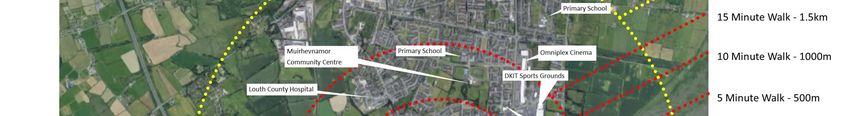
The site is located within lands which form the bulk of
            the first mixed use “Development Cell” within the Mul-
            lagharlin Framework Plan.
            The Plan states:
            The Finnabair South area will provide for a mixed-use
            area south of the DKIT comprising of         employ-
            ment, commercial development, health care, student
            and residential housing and may          incorporate
            links to the adjacent Dundalk Golf Course.
            The area will be well connected with a network of foot-
            path and cycle-ways linking the various sites, encom-
            passing new pedestrian friendly lighting to further pro-
            mote community safety.
            The site specific objective for the Finnabair South Area
            is:
            Accommodate a mixed use low energy urban         quarter
            in an attractive landscape setting.
            The area shall accommodate residential development
            at a medium to high density as part of a mix with com-
            mercial/employment uses.

1.3 Mullagharlin Framework Plan
EMPLOYMENT   3RD LEVEL EDUCATIONAL   MIXED USE          MULLAGHARLIN FRAMEWORK PLAN

                                                                                       Lands already developed or under development

                                                                                       Finnabair Industrial Estate
                                                                                       Multihog, Horseware, Irish Life, Boyle Sports, Spec-
                                                                                       tac, Authentic Food Co. and IDA Advanced office build-
                                                                                       ing under development. Additional Irish Life building
                                                                                       under development also.

                                                                                       Green Park
                                                                                       Crown Plaza Hotel, Nursing Home, Student
                                                                                       Accommodation
                                                 SITE

                                                                                       Xerox Business Park
                                                                                       Xerox, National Pen, Norbrook Laboratories, Paypal
                                                                                       and Furniturelink.

                                                                                       Wasdell Pharma Plant
                                                                                       Under development

                                                                                       Wuxi Pharma Park
                                                                                       Under development

                                                                                      1.4 Surrounding Uses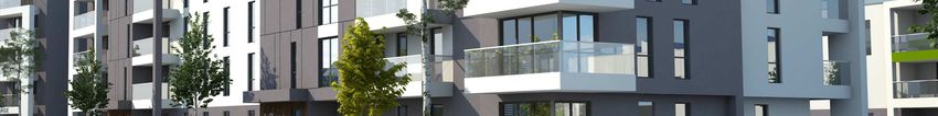
EXISTING AND PLANNED / UNDER CONSTRUCTION EMPLOYMENT
Within walking distance of the site there are existing or planned / under construction businesses with an
employment capacity of over 6000 people.

Illustrations show National Pen, Finnabair Office Park, IDA Advanced Office Building (under     Construc-
tion), Former Actavis Plant (Now Norbrook) Paypal, Irish Life (Under Construction) and Wuxi (In Planning).

                                                  1.5 Surrounding Uses
The lands lie at the heart of the Dundalk 2020 Energy
Zone created by SEAI and supported by EU Concerto
Funding with an emphasis on the development of sus-
tainable buildings and homes. Linkages between end
users is encouraged e.g. between DKIT and Mixed Use
zone to South with a further emphasis on living within
walking / cycling distance of employment and 3rd Level
Educational opportunities.
1.6 Dundalk 2020 Energy Zone2.0 Site Analysis
NETT SITE
  AREA      NETT SITE
              AREA

                        2.1 Site Analysis
NETT SITE
AREA NETT SITE
AREA
2.2 Site AnalysisNETT SITE NETT SITE
AREA AREA
2.3 Site AnalysisView looking East along Inner Relief Road showing existing bus stop along site boundary. View looking East from Old Dublin Road
View looking West from along Inner Relief Road showing View looking North along Old Dublin Road
View looking South from DKIT Campus
existing cycle-path
2.4 Site Analysis3.0 Design Proposals
SITE LAYOUT

       It is proposed to locate 142 Apartments in five buildings with a
       creche and community room within the central portion of the
       site.
       It is intended that the apartments would be aimed at the Private
       Rented Sector (PRS) scheme which apart from the necessary
       Part V element would be targeted at the accommodation needs
       of internationally mobile employees in the existing and planned
       businesses within the Mullagharlin Framework Plan.
       The two eastern buildings (Four storeys + setback storey) are
       designed to be of a similar height to the already granted office
       building at the entrance to the site. These blocks are intended
       to form the “spine” of the overall scheme providing an appropri-
       ate urban edge to the main avenue.
       The three western blocks are primarily three storeyed but step
       down from that to two storeys at their western end to appropri-
       ately relate to the adjoining existing residential.
       In accordance with the Mullagharlin Framework Plan, “Buffer”
       planting has been provided to the rear of those houses. This
       buffer planting provides an edge to the significant public open
       space both between the three small blocks and to the western
       side of the plot which will be available for the occupiers of the
       apartments and the employees of the surrounding business
       park.

Area shaded grey :
Granted Planning Permission PL 15.247927
PA 16 / 803

                                   3.1 Site Layout
Overall Development including approved office and R+D units
Proposed Employment Related Residential in central area
3.2 ProposalURBAN EDGE
The two 5-storey buildings bound the western side of the spine
road of the overall development from Dundalk Institute of
Technology and the Inner Relief Road through to the future
Finnabair South development lands which lie to the South of the
approved business park development.
Conceptually we have imagined these as a strong urban edge
to the spine road with the main entrances to these buildings
fronting onto the spine road to provide an active ground floor.
Visually the important northern and southern corners of the
blocks where access roads pass around them to both the rear
apartments and the adjoining employment uses, have been
emphasised with L-shaped corner balconies and full 5-storeyed
corner features. Similarly the main entrance elements have
been highlighted with a change in materials both in terms of the
vertical features and in detail around the entrance areas.
3.3 Design ProposalsMASSING, OVERLOOKING AND OVERSHADOWING
The larger Blocks (A Type) are oriented on a rough North South
axis and combined with the higher portion of the approved office
building beside the entrance to the business park they form the
spine of the overall business park development. These blocks
are four storeys plus a setback storey with portions such as
corners and entrance features defined as full five storeyed
elements.
Perpendicular to the main spine of buildings, three pavilion style
blocks are set in landscaped gardens stepping down from 3-
storeys to 2-storeys nearest the adjoining residential dwellings
facing the Dublin Road.
Significant separation distances have been adopted with a
minimum of 32.5m from the 2-storeyed and 45.5 from the 3-
storeyed elements of these pavilion buildings to the main body
of any of the adjoining private residences. To the rear gardens
the minimum separation distance is 17.9M
The taller 4/5-storyed blocks are a minimum of 85 metres from
the existing houses.
Min. 85m
Min. 45.5m
Min. 32.5m
3.4 Design ProposalsELEVATIONAL APPROACH
The proposed design achieves a contemporary style of
architecture which is stylish, residential and in keeping with the
approved business park development, Crown Plaza on the
opposite side of the road and the planned and existing
employment use buildings in the area (see site context).
In that light we have proposed a mix of materials with white
coloured render / white brick as the main finish with stone / zinc
coloured panelling to feature areas.
The external more public sides of buildings have more of the
grey stone / zinc coloured elements while garden elevations are
more simple “white” architecture softened by the garden
planting.
The elevational style is similar to an already approved and
under construction development on similarly zoned land at
Northwood, Santry, Fingal by the same architects.
3.5 Design ProposalsMATERIALS
Contemporary materials of white brick, Zinc coloured cladding,
Cedar cladding to setback storey and inside of enclosed
balconies, glass balustrades and sliding grey aluminium
windows and doors.
Any cedar cladding will be heat sealed to avoid maintenance
issues and well protected by overhangs / balconies.
All other external materials are minimum maintenance.
3.6 Design ProposalsAPPROACH TO PUBLIC REALM
The intention for the overall development of which the
application site is a part, is to create a highly landscaped, pe-
destrian and cycle friendly development with a safe, secure and
accessible “eco friendly” children's play area.
However, this is not at the expense of the development being
URBAN in nature and scale.
The public realm is effectively split between the avenue spine
road with future traffic to and from the lands to the South, and
the highly landscaped garden, access and play areas to the
west side. Within these areas cars would be limited to parking
and shared surface areas in compliance with DMURS.
CAR PERMEABILITY OPEN SPACE PUBLIC AVENUE
AMENITY
NETT SITE
AREA
3.7 Design ProposalsPUBLIC / PRIVATE AMENITY SPACE
A range of outdoor amenity spaces will be provided including a
walking / running track through the development, garden areas
to the west of the apartments, an informal children’s play area
close to the apartments, generous balcony spaces provide
private open space to the apartments with favourable aspect.
The scheme has the added benefit of a community room while
nearby the DKIT Sport Centre and Felda Leisure Centre provide
additional recreational opportunities.
3.7 Design ProposalsAt the pre-application consultation the question was raised
about the overall phasing of the site.
Currently, negotiations are underway with a number of potential
end users for buildings within the granted permission for
employment uses on the site and if these come to fruition during
the course of this application then one or other of these may
proceed ahead of the proposed SHD development. If such is
not the case then it is envisaged that phasing will occur as
shown on the attached diagram.
All works to the public road will be carried out within Phase 1.
Phase 1
Phase 2
Phase 3
Phase 4
3.8 Overall Development PhasingFrom “Urban Design Manual – A Best Practice Guide”, Department of Environment, Heritage and Local Government, May 2009. 4.0 Quality Urban Design Assessment
Surroundings:
The overall development cell site with an area of 5.229 Hectares forms the north-western sector of the proposed Finnabair South character area within
the Mullagharlin Framework Plan which is a strategic vision for the development of this area within the Dundalk and Environs Local Area Plan. The site
is located between the Xerox Technology Park to the west and the Finnabair Business Park to the east, with the IDA Offices located on lands to the
east. These parks are occupied by a number of high profile national and international employers including Paypal, Xerox, Authentic Foods, National
Pen and Horseware along with a range of small and medium sized enterprises. Dundalk Institute of Technology (DKIT) and Green Park with the
Crown Plaza Hotel is located just north of the site on the opposite side of the Inner Relief Road. The western boundary largely comprises the rear
gardens of residential dwellings that front onto the Dublin Road. Work is ongoing on the development of further employment uses adjacent to the park
including Irish Life (300 jobs), IDA AOB (Est. 300 jobs), Wasdell, (350 jobs) and Wuxi (Phase 1 400 jobs).
The proposed development forms part of an independent cell that is connected to the wider framework area. The provision of residential
accommodation to support the permitted employment development and future business park development is fully compliant with the Development Plan
and Framework Plan. The site area for the residential development proposed amounts to 1.5194 ha which represents 29% of the development cell
area.
Appropriate increase in density:
The proposed residential development represents a high density development in close proximity to a mix of commercial and employment uses as
envisaged by the Framework Plan. A maximum building height of 3 storeys is prescribed adjacent to existing residential development. This
requirement is met and indeed the proposed apartment buildings reduce to 2-storey height to take account of the existing residential dwellings beyond
the western site boundary. The minimum separation distance to the western site boundary is17.9M.

Form, architecture and landscaping:
The proposed apartment buildings fully reflect the layout of the framework plan in terms of connectivity and form of buildings. The buildings provide a
strong building line along the boulevard while respecting the existing lower density residential development beyond the western boundary. The
perimeter block style allows the interior of the block to accommodate car parking and open space amenity areas for the residents. Significant
landscaping is proposed along the western boundary to provide a buffer area between the rear gardens of houses on the Dublin Road and the
proposed development. Landscaping also provides privacy for ground floor apartments.

Character and identity of neighbourhood
The proposed development forms part of a development cell that is permitted under P.A. Ref. 16/803/ABP Ref. PL15.247927. The development takes
full account of its setting and context, stepping down in height towards the western boundary where existing single storey residential dwellings front
onto the Dublin Road while providing a strong urban edge and streetscape along the new access road. The development site is in an area
characterised by taller buildings and structures including the Crowne Plaza Hotel. This site forms the Gateway to the Mullagharlin Framework Plan
Finnabair South Character Area. The design reflects the aim of the MFP to create a new urban quarter .

Specific boundary conditions:
The proposed development protects the privacy of both existing residents on the Dublin Road to the west of the site and future residents.
The design of the apartment buildings along the western boundary, locates the narrowest elevation facing the rear of existing residents on the Dublin
Road. All buildings exceed the minimum required separation distances. In addition, generous landscaping will provided a buffer zone between the rear
gardens of these dwellings and the proposed apartment buildings.

 See Site Context Drawings and Site Analysis Drawings in sections 1 and 2

                                                                                                                             4.1 Context
Movement Routes:
The site is within a five minute walk of the following:
Dundalk Institute of Technology, Finnabair Industrial Estate,
XEROX Business Park , Louth Creative Spark , Crown Plaza
Hotel
The site is within a ten minute walk of the following:
Louth County Hospital, Dundalk Retail Park, Dunnes Stores
Neighbourhood Shopping, DKIT Sports Complex, Felda
Leisure Complex,
The site is within a fifteen minute walk of the following:
Entire Mullagharlin Framework Plan Area, Dundalk Golf
Club, TESCO Extra.
Planned Wasdell and Wuxi Developments, Supervalu
Neighbourhood Shopping.
Dundalk town centre is accessible within a 10 minute
cycle distance.
4.2 ConnectionsPedestrian Routes: Pedestrian
pathways along internal roads are
accommodated in accordance with the
Mullagharlin Framework plan and designed
to meet DMURS standards and incorporate
recommended DMURS speed reduction
and safety features such as raised tables at
EX. BUS STOP junctions in addition to signalised toucan
crossings with tactile paving and dropped
kerbing. The site is in walking distance to
shopping and community facilities.
Mixed Use Centre: The development is
located within a mixed use low energy
urban quarter in an attractive landscape
setting.
Bus route: There are bus stops located
80m from the proposed apartments on the
R215 and a good level of bus services
available on the Dublin Road. The applicant
is open to the extension of bus services
within the application site in the future.
Efficient Public transport:
There is an existing bus stop located just
beyond the permitted entrance to the IRR
R215. This bus stop is less than c. 300m
walk from the application site. There is a
second bus stop located c 500m further
north at the front entrance to DKIT. The
4.2.1 Primary Pedestrian Connections
Bus StopCycle Routes:
The site is located in close
proximity to existing cycle routes
and proposed cycle routes as
contained within Louth County
Council’s Go Dundalk- Smarter
travel Cycling Strategy.
Cycle ways along internal roads
are accommodated in accordance
with the Mullagharlin Framework
plan and designed to meet
DMURS standards and incorporate
recommended DMURS speed
reduction and safety features such
as raised tables at junctions in
addition to signalised toucan
crossings with tactile paving and
dropped kerbing. A two way
segregated cycle track is also
proposed along the main access
road. The proposed development
includes for cycle lanes to join into
the existing cycle lane network in
Dundalk and in time, to other lands
Pedestrian and cycle Routes connections in the Mullagharlin Framework
Plan area.
4.2.1 Cycle ConnectionsRange of people and households:
The proposed development includes the allocation of 14 no. of units to social housing in compliance with Part V requirements. It is likely that a further 2
units will de added to that so an entire block can be managed. We have entered into talks with Tuath Housing Association and Louth County Council in
this regard. A letter confirming this from Tuath is included with the application.
While the development is aimed at rented accommodation for employees of the growing foreign direct investment companies in the Mullagharlin
Framework Plan, a range of apartment types has been proposed to satisfy the differing likely needs of that target audience.
The following mix of apartments is provided:
58 No. 1-Bed Apartments 41%
64 No. 2-Bed Apartments 45%
20 No. 3-Bed Apartments 14%
Access for all
The proposed apartment buildings will be fully compliant with all Building Regulations and include lift access to all apartments. Disabled car parking
spaces are provided in keeping with the requirement of the DEDP and LCDP.
Open space for all:
The proposed development includes 3120 sq.m of communal open space equating to 20.5% of the site area. Communal open space is provided as
Nett landscaped seating areas as well as a children’s play area. All apartments have their own area of private open space either as terraces at ground floor
or balconies on upper floors.
All apartments meet and exceed the minimum criteria for private amenity space as detailed in the Sustainable Urban Housing: Guidelines for New
Apartments (March 2018). Private amenity space is provided by way of terraces at ground floor level and balconies on upper floors. All balconies have
a desirable aspect and are connected to the main living areas.
Public amenity space is provided in a variety of forms including a children’s play area that is centrally located within the development with good passive
surveillance. It is envisaged this playground will serve children in the age group of 4-8 years old. Landscaped gardens and seating areas are also
proposed as set out in the detailed landscape drawings.
Buildings to present positive aspect
The buildings provide active frontage and an animated streetscape. They are welcoming to passersby and also provide privacy to the occupants by
means of a planted buffer strip to apartment living areas.
4.3 InclusivityThe scheme provides for a total of 15 number apartments
which incorporate design features that are in line with a
universal design approach.
A
G
Design features that are in line with a universal design B
approach F
C
A Entrance door with a clear width of circa 950mm
B Wide hallway of circa 1200-1500mm with storage
C Circa 1800-2400mm turning circle in all habitable rooms
D Kitchen arranged to allow accessible access to all units
E Easily adaptable with ‘soft-spots’ H
eg internal walls to change from two bedroom layout to E
one larger bedroom (highlighted in red).
F Bathroom immediately adjacent to the main bedroom.
G WC can be accessible.
H Provision of ‘hard-spots’ eg in ceiling construction for D
hoist track to be installed in bedroom.
4.3 InclusivityContribution towards quality of life
The Finnabair South sector of the Mullagharlin Framework Plan is envisaged as an area specifically zoned to serve those needs of the extant and
future development of the entire area. There is a clearly expressed need for social housing in Dundalk and for additional residential development to
specifically service the employees of Paypal and National Pen. The location of the site within walking distance of these facilities will contribute to the
quality of life for associated workers.
Uses that attract most people are in the most accessible places
The entire development is designed to be very accessible with uses relating as closely as possible to the adjoining appropriate uses.
Neighbouring uses are compatible with each other.
The residential accommodation uses are located in close proximity to existing residential areas and are located on one side of the access road while
the employment uses are predominantly the other side. The property benefits from a recently granted planning permission for offices and research and
technology buildings. The development granted includes:
Building A is the largest of the office buildings, with a gross floor area of 2,880 sq.m. In keeping with the urban design requirements of the
Mullagharlin Framework Plan it consists of an L-Shaped 'gateway' building with long frontages facing towards the Inner Relief Road and onto the
new north-south access road.
Building B extends to 960 sq.m in area and consists of a 2 no. storey rectangular block. It is located to the west of Building A in the north-western
corner of the application site. It is proposed that Building B will accommodate office/research and development/science and technology uses.
Building C also measures 960 sq.m in area and consists of a 2 no. storey rectangular block. It is located to the east of the proposed north-south
access road that serving the development with its long side facing towards the road. It is proposed that Building B will accommodate office/research
and development/science and technology uses.
Building D is a 2 no. storey building containing 2 no. separate units each with a gross floor area of 240 sq.m. It is proposed these units will be uses
for research and development/science and technology uses.
B A
Building F is similar and shape, form and size to Building E consisting of a 2 no. storey building accommodating 3 no. separate units each
extending to 240 sq.m in area. It is proposed these units will be uses for research and development/science and technology uses.
Buildings G and H are located in the south-western part of the site on the western side of the proposed north-south access road. These buildings
mirror Building D in shape, form, size and height each accommodating 2 no. units for research and development/ science and technology uses over
C 2 no. floors.
Housing types and tenure add to the choice available in the area.
Nett Site The residential component of the project will contain both social housing (to be owned and managed by an approved housing body) and private rental
Area D accommodation (to be owned and managed by investor/s) which will be an immediate response to the identified need for such accommodation in this
particular location.
Opportunities have been taken to provide shops, facilities and services that complement those already available in the neighbourhood.
E
The development will contain a crèche and a community meeting facility. Other services and facilities are readily available in the neighbourhood. These include the
Fairways neighbourhood centre and Dunnes Neighbourhood centre at Hoey’s Lane.
H F
G
4.4 VarietyThe proposal looks at the potential of higher density taking into account appropriate accessibility by public transport and the objectives of
good design.
The development is significantly more dense than the developments around it. The density is seen to be appropriate in terms of its’ use of scarce
resources (including land) while bridging the difference between the lower density extant development along the R132 and the higher densities
appropriate to the urban setting of the R215 Inner Relief Road. A density of 93.5 Units per Hectare is achieved which is appropriate to the URBAN
quality intended for the business park and other developments around this hub serving the town cores and adjoining employment uses. Density and
dwelling type are also compliant with national policy guidelines issued in 2018, including the NDP and the Apartment guidelines.
It is contended that 2-5 storeys is the minimum appropriate response in terms of scale to the 14 storeyed Crown Plaza Hotel on the opposite
side of the Inner Relief Road.
Landscaped areas are designed to provide amenity and biodiversity and protect buildings and spaces from the elements and incorporate
sustainable urban drainage systems.
The landscape plan for the development includes a childrens’ playground with safe rubber surfacing and seating areas. The existing hedgerow to the
east will be maintained along side new high quality planting of the open spaces, buffer zone and frontage to the R215. A full scheme of Sustainable
Urban Drainage has been incorporated into the design. Our landscape architect Paul Martin has won numerous awards for high quality bio diverse
contemporary gardens including in the last few weeks a gold medal at the Singapore Landscaped Garden awards.
Buildings gardens and open spaces are laid out to exploit the best solar orientation.
Higher density apartments in Block Type A are oriented in an east-west direction to benefit from dual aspect morning and evening sunlight. In Block B,
the layout of the apartments are predominantly dual aspect and where single aspect units are provided they face South. Overall there are 73 dual
aspect apartments with 69 single aspect apartments.
Open spaces will include planting to provide shelter from the prevailing South West winds. Afternoon and evening sun will penetrate the designated
open space areas.
The scheme brings a redundant building or derelict site back into productive use.
This objective is not relevant to this development but it should be pointed out that the lands are surrounded by extant industrial, educational and
residential development centrally located within the Dundalk and Environs Local Area Plan and as such their usefulness as agricultural land is
becoming increasingly tenuous.
Appropriate recycling facilities are provided.
Screened Bin storage and recycling facilities are provided within the development as appropriate.
4.5 EfficiencyThe place has recognisable features so that people can describe where they live and form an emotional attachment to the place.
The site is located in close proximity to two landmarks within the town, The crown plaza hotel and Xerox / Paypal campus. The design of the residential
dwellings responds to the scale of the adjacent developments and have been designed within a landscaped parkland setting.
The scheme is a positive addition to the identity of the locality.
In designing the 14 Storeyed Crown Plaza Hotel and the Green Park development on the opposite side of the N52, it was envisaged that this area
would become a “hub” servicing the entire Mullagharlin Framework Plan area. The Crown Plaza suffers from a massing point of view in not having
sufficient substantive accommodation constructed around it. The recent granting of planning permission to further development on the Green park
lands will hopefully begin the process of completing the vision for the area of which the Crown Plaza was part.
The development of this site to provide much needed residential accommodation will further enhance that process.
The layout makes the most of opportunities presented by existing buildings, landform and ecological features to create a memorable layout.
A key feature of this site is its’ potential to act as a gateway between the Institute of Technology and the Finnabair South quarter. The layout of the
development with a central boulevard with where possible a substantial “urban edge” emphasises this approach. The location of the employment uses
on the higher ground to the East of the site emphasises their importance in accordance with the Mullagharlin Framework Plan.
The proposal successfully exploits views into and out of the site.
Views from the proposed development towards the Institute of Technology are a clear feature of the design of this part of the development. The
frontage to the R215 and R132 have both been exploited to facilitate views into the site.
There is a discernible focal point to the scheme or the proposals reinforce the role of an existing centre.
The proposed development integrates into development permitted within the development cell. Urban edge reinforces gateway to The inclusion of
residential accommodation within the overall site will ensure that the centre is constantly active and in use. Within the application site, landscaping
provides a focal point, and a potential meeting point, in centrally positioned open space amenity areas and play area. Crown Plaza has been
recognised as a good example of a well-designed and located taller building as per the ‘Urban Development and Building Heights, Guidelines for
planning Authorities-Consultation Draft 2018’.
During the development of these proposals the following design
precedents have been used as inspiration for key areas of the
design
Screened Facades
Using a series of screens to main elevations help provide shelter to
external private space.
Core
Variation in material to the facades creates legibility to vertical
circulation routes
Massing and articulation
Different options were explored and the strategy chosen was to
recess balconies at the upper level overlooking the
Screened Facades Core Massing and articulation
4.6 DistinctivenessLayout aligns routes with desire lines to create a permeable interconnected series of routes that are easy and logical to navigate around.
The layout is an extremely clear fish bone structure with a main North South access road and adjoining pedestrian route punctuated by a series of East-West
pedestrian and vehicular routes.
The layout focusses activity on the streets by creating active frontages with front doors directly serving the street.
While there is a mix of uses on the site, wherever possible active frontages have been incorporated along streets.
The streets are designed as places instead of roads for cars, helping to create a hierarchy of space with less busy routes having surfaces
shared by pedestrians, cyclists and drivers.
The development includes a hierarchy of roads with the main access boulevard leading to shared surface subsidiary routes.
Traffic speeds are controlled by design and layout rather than by speed humps.
Of necessity given its role in linking the Institute of Technology and the Finnabair South lands the main access route is designed as a straightforward route although
its curved alignment will begin to slow traffic. In addition raised tables are included at the junctions with the minor cul-de-sacs off the access road. The shared surface
cul de sacs will naturally slow traffic.
Block layout places some public spaces in front of building lines and some semi private space to the back as communal courts.
The amenity open space shared by all users of the development is immediately off the main boulevard opposite the residential development while a series of semi
private gardens are laid out along the Western boundary to the rear of the residential blocks.
See Public Realm in Section 2.
CAR PERMEABILITY OPEN SPACE PUBLIC AVENUE
AMENITY
NO THROUGH VEHICULAR ROUTE WITHIN THE DEVELOPMENT
4.7 LayoutAll public open space is overlooked by surrounding homes so that this amenity is owned by the residents and safe to use.
The landscape plan has been designed to maximise permeability, movement and social interaction through the creation of a series of convivial open spaces
connected by a series of landscaped walkways that are direct, safe and easy to use by all.
The public realm is considered as a usable integrated element in the design of the development.
A variety of open spaces are provided which encourage connectivity and permeability through the site while meeting the amenity needs of the residents and other
occupants of the site.
Children’s play areas are sited where they will be overlooked, safe and contribute to the amenities of the neighbourhood.
An informal childrens play area has been located in the open space which is most accessible from the residential units within the development. It will be immediately
overlooked by residential dwellings.
There is a clear definition between public, semi private and private open space.
Boundary details included with the landscape design proposals show how the different types of open space within the development will be demarcated.
Roads and parking areas are considered as an integral landscaped element in the design of the public realm.
The landscape layout attaching to the application shows how the shared surface streets, raised tables and boulevard are all integral to the landscape structure within
the development.
4.8 Public realmDesigns exploit good practice lessons such as the knowledge that certain house types are proven to be ideal for adaptation.
A variety of residential types are included within the development specifically design to meet the short and medium term needs of the Mullagharlin
Framework Plan. The blocks will be designed with concrete frames to allow for future adaptation should that be required.
The homes are energy efficient and equipped for challenges anticipated from a changing climate.
The homes will be designed to include passive solar techniques and local renewable energy generation in excess of that required by the building
regulations. They are located within the Dundalk 2020 Sustainability Zone and as such it would be the intention of the developer to seek funding from
EU Concerto funds to carry out monitoring and further upgrading of the sustainable proposals included in the application.
See Sustainability Statement by Morley Walsh.
Homes can be extended without ruining the character of the types, layout and outdoor space.
Not applicable to this development.
The structure of the home and its’ loose fit design allows for adaptation and sub-division such as the creation of an annexe or small office.
Not applicable to this development.
Space in the roof or garage can be easily converted into living accommodation.
Not applicable to this development.
4.9 AdaptabilityEach home has access to an area of useable private outdoor space.
Ground Floor apartments have private terraces whilst upper floor apartments have balconies in accordance with sustainable housing guidelines.
The design maximises the number of units with dual aspect.
Of the 142 Residential Units there are 51.4 % Dual aspect units with 48.6% single aspect apartments which are predominantly 1-bed apartments. The
orientation of the blocks is such to maximise the south facing single aspect apartments.
Homes are designed to prevent sound transmission by appropriate acoustic insulation or layout.
All units will incorporate acoustic insulation / details to ensure that any party walls or floors achieve the acoustic requirements of the Building
Regulations.
Windows are sited to avoid views into the home from other houses or the street and adequate privacy is afforded to the ground floor units.
Landscaped buffer zones (minimum 2m deep) have been included between footpaths and ground floor units to provide adequate privacy zones.
Distances between three storeyed blocks with substantive glazing or balconies are a minimum of 29m. Distances from the façade of the larger blocks
and the less glazed gables of the smaller blocks is a minimum of 22m. Distances to adjoining existing residences are greater than the minimum
allowable in the development plan or national house design guidelines.
The homes are designed to provide adequate storage including space within the home for the sorting and storage of recyclables.
Dual Single Dual Single Storage in each unit has been provided in accordance with Design Standards for New Apartments - Guidelines for Planning Authorities (March 2018).
aspect aspect aspect aspect Internal, covered and casual cycle storage has been provided.
A B
Ground 3 5 4 2 Recyclable storage will be provided within kitchen units and as part of communal bin storage / recycling areas.
1st 4 7 4 2 Note:
2nd 4 7 3 1 See Shadow Study accompanying the application showing that the buildings will have no negative impact on the adjoining residential properties
3rd 4 7 ( Sample extracts below)
4th 5 1
SUB 11 5 20 27
TOTAL
33 15 40 54
TOTAL 73 69
4.10 Privacy and AmenityAppropriate parking is on-street or within easy reach of the home’s front door.
Parking for the development has been provided in accordance with the the Traffic Impact Assessment, and Mobility Management Plan prepared by Roughan
O’Donovan and attached with the application.
The development is specifically targeted at satisfying a particular need within the Mullagharlin Framework Plan for the accommodation of internationally mobile
employees. These employees usually come from countries with more developed public transport systems. The development is sited within walking / cycling distance
of both the employment locations and all relevant amenities necessary. It is envisaged that car use will not form a major factor in the transport needs of the occupiers
and this has been taken into account in the TIA / MMP. The development proposes 146 car parking spaces, 1 per apartment with an allowance of 4 for the crèche
facility. There are 2 cycle parking spaces per apartment.
Parked cars are overlooked by houses, pedestrians and traffic or stored securely with a choice of parking appropriate to the situation.
A variety of parking opportunities are provided including ESB charging points and dedicated parking for the crèche facility. All of which are overlooked for passive
surveillance reasons with some suitable for residents and others more suitable for visitors.
Parking is provided communally to maximise efficiency and accommodate visitors without the need to provide additional dedicated spaces.
The development has been designed with sufficient car parking provision and in addition a high level of secure cycle parking provision.
Materials used for parking areas are of similar quality to the rest of the development.
A permeable asphalt finish will be used in the parking areas to contribute to align with SUDS requirements.
Adequate secure facilities are provided for bicycle storage.
A variety of bicycle storage is provided with simple outdoor locking racks , covered racks and a fully secure enclosed bicycle store for the residential accommodation.
4.11 ParkingThe materials and external design make a positive contribution to the locality.
The buildings are designed to be contemporary and similar in style to the recently granted buildings within the Green Park development on the
opposite side of the R215. See Materials and Elevations parts of Section 1.
The landscape design facilitates the use of public spaces from the outset.
The development of the residential portion of the development will incorporate the contemporaneous development of the adjoining public, semi private
and private open spaces. These will be carried out to a high quality in accordance with the Landscape drawings being submitted with the application. It
should be noted that as this is likely to be a long term managed Private Rental Sector development, it is in the interest of the investors to construct
durable, high quality minimal maintenance details conducive to good quality design and long term durability..
Design of the buildings and public space will facilitate easy and regular maintenance..
Opens spaces are immediately accessible for maintenance purposes and are clearly visible to users of the site and the wider public to encourage their
maintenance.
Features within the open space and the buildings themselves will be designed to minimise maintenance requirements.
Open car parking areas are considered as an integral element within the public realm design and are treated accordingly.
This approach has been incorporated into the design of the development.
Care has been taken over the siting of flues, vents and bin stores.
The use of recessed balconies should assist in hiding flues and vents. Care will be taken at detailed design stage that flues and vents will not be
unsightly and will not be located where stained can occur on surrounding finishes.
The Bin enclosures have been designed to be properly screened and at a distance from nearby windows to avoid an odour issues but centrally located
within the developments so that they are easily accessible for occupiers from the entrance areas within apartment blocks.
4.12 Detailed Design5.0 Conclusion
Conclusion
                                                                                       We believe that this proposal is highly appropriate in terms of the needs of the
                                                                                       surrounding and planned employment uses, the appropriate development of
                                                                                       the Mullagharlin Framework which is a key driver in the development of
                                                                                       Dundalk in accordance with the National Planning Framework.
                                                                                       The development is complementary in use terms to the adjoining existing
                                                                                       residences and is designed in a style appropriate to the developing high
                                                                                       quality service hub created by the DKIT, Green Park and this proposed
                                                                                       business park all serving the major employers within the Mullagharlin
                                                                                       Framework Plan area.
                                                                                       It has been designed in a similar manner to a development of apartments in
                                                                                       Northwood, Santry by the same architects which was granted planning
                                                                                       permission by Fingal County Council on similarly zoned employment and
                                                                                       business lands and which is now under construction.
                                                                                       The development is sustainable in terms of the efficient use of land, the
                                                                                       location of accommodation within walking and cycling distance of employment
                                                                                       and 3rd level educational opportunities and in the incorporation of NZEB /
                                                                                       Renewable energy features.
                                               Northwood Development, Santry, Dublin

Quality Assessment
This Design Statement was reviewed and approved by:

                                                                                       Signed: Caroline Whately MRIAI
                                                                                       Van Dijk Architects

                                                                                                             5.0 CONCLUSION
Head Office Mill House, Mill Street, Dundalk, Co. Louth, Ireland (P) +353 42 9354466 ( E) info@vandijkarchitects.com Web : www.vandijkarchitects.com Also At Mill House, 8, Mill Street, London SE1 2BA, UK VDI Poland Sp.z o.o. No. 41A/6 Swieradowska Street, 50-559 Wroclaw POLAND VDI Project Management Ltd. HDS Business Centre 3204, (Cluster M), Jumeirah Lakes Towers Dubai, UNITED ARAB EMIRATES Unit J, Auto Moto Business Park, King Faisal Road, Ar Rakah, Al Khobar KINGDOM OF SAUDI ARABIA
You can also read