NCDEQ RISK CALCULATOR USER GUIDE - NORTH CAROLINA DEPARTMENT OF ENVIRONMENTAL QUALITY - NC.gov
←
→
Page content transcription
If your browser does not render page correctly, please read the page content below
NORTH CAROLINA
DEPARTMENT OF ENVIRONMENTAL QUALITY

  NCDEQ RISK CALCULATOR
          USER GUIDE

             February 2021
TABLE OF CONTENTS

1.0     INTRODUCTION ............................................................................................................... 1
  1.1      Key Terms and Concepts ................................................................................................. 1
  1.2      Risk Calculator Cell Color Codes .................................................................................... 3
2.0     GATHERING SITE INFORMATION ................................................................................ 3
  2.1      Site Contamination ........................................................................................................... 3
  2.2      Exposure Pathways .......................................................................................................... 3
  2.3      Receptors .......................................................................................................................... 4
  2.4      Exposure Units ................................................................................................................. 5
3.0     USING THE RISK CALCULATOR................................................................................... 7
  3.1      Project Information and Report Organization Section ..................................................... 8
      3.1.1      Cover Page ............................................................................................................................ 8
      3.1.2      Table of Contents .................................................................................................................. 9
      3.1.3      Select Sheets to Print Button ............................................................................................... 10
  3.2      Site-Specific Data Input Section .................................................................................... 10
      3.2.1      Complete Exposure Pathways ............................................................................................. 10
      3.2.2      Exposure Factors and Target Risks ..................................................................................... 14
      3.2.3      Contaminant Migration Parameters .................................................................................... 16
      3.2.4      Sample Statistics ................................................................................................................. 17
      3.2.5      Data Input - Exposure Point Concentrations ....................................................................... 17
  3.3      Data Output Sheets ......................................................................................................... 22
      3.3.1      Summary Output for All Calculators .................................................................................. 23
      3.3.2      Direct Contact Soil and Water Calculators ......................................................................... 24
      3.3.3      Vapor Intrusion Calculators ................................................................................................ 25
      3.3.4      Sitewide Human Health Risk Summary ............................................................................. 27
  3.4      Contaminant Migration Worksheets .............................................................................. 28
      3.4.1      Soil Leaching to Groundwater Calculations ....................................................................... 29
      3.4.2      Groundwater Migration Calculations.................................................................................. 31
      3.4.3      Surface Water Dilution Calculations .................................................................................. 31
      3.4.4      Model Verification for Transport Pathways ....................................................................... 32
  3.5      Unprotect All Sheet and Protect All Sheets ................................................................... 33
4.0     CALCULATING CLEANUP LEVELS ............................................................................ 33
  4.1      Remedial Goals for Direct Contact Pathways ................................................................ 34
  4.2      Remedial Goals for Indoor Inhalation Pathways ........................................................... 34
5.0     REPORTING ..................................................................................................................... 35
6.0     REFERENCES .................................................................................................................. 36

                                                                                                                    Risk Calculator User Guide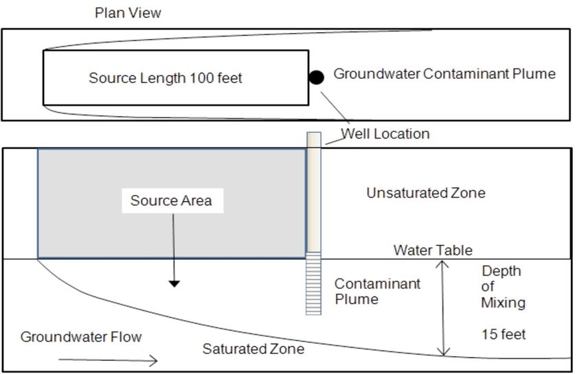
For questions related to information presented in this user guide, please contact:

                               Janet Macdonald
                                (919) 707-8349
                         janet.macdonald@ncdenr.gov

                                       or

                                  David Lilley
                                (919) 707-8241
                            david.lilley@ncdenr.gov

                       Division of Waste Management
             North Carolina Department of Environmental Quality
                             217 W. Jones Street
                          1646 Mail Service Center
                       Raleigh, North Carolina 27699

                                                                  Risk Calculator User Guide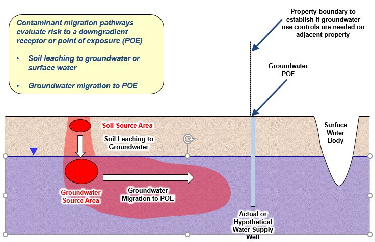
1.0 INTRODUCTION

The North Carolina Department of Environmental Quality (NCDEQ) Risk Calculator has been
developed to evaluate the risks of multiple contaminants and multiple exposure routes associated
with contaminated environmental media at a site.

The Risk Calculator is an Excel-based, menu-driven program. The risk evaluation procedures,
equations, and default parameters used to create the calculator follow current United States
Environmental Protection Agency (USEPA) risk assessment guidance. Refer to the Risk
                                      Evaluation Resources page on the NCDEQ Risk-Based
                                      Remediation website for a link to the list of equations and
  In    addition   to    risk-based   default parameters used in the calculator.
  remediation for site closure, the
  Risk Calculator has also proven         The Risk Calculator incorporates a database that contains
  helpful in refining excavation limits,
                                          toxicity values and other chemical-specific parameters
  determining the quality of imported
                                          obtained directly from the USEPA Regional Screening
  or exported soil, directing vapor
                                          Level (RSL) Tables. The Risk Calculator will be updated
  intrusion evaluations, and siting
  monitoring wells for assessment.        when the RSL tables are updated by USEPA, typically
                                          twice per year.      Where USEPA default exposure
parameters or inputs are not available, the NCDEQ has established North Carolina specific factors
or adopted those used in nearby states. Some of these defaults cannot be changed by the user
because the worksheets are “protected” and can only be “unprotected” by a NCDEQ toxicologist.

This Risk Calculator User Guide (Guide) describes the data needs and functionality of the Risk
Calculator and provides instructions on its use. For general procedures on how to use these risk
assessment results to implement a risk-based remedy according to N.C.G.S 130A-310.65 through
310.77, refer to the Technical Guidance for Risk-Based Environmental Remediation of Sites
(Technical Guidance).

1.1    Key Terms and Concepts

Combined Pathways – An Exposure Pathway that includes the primary routes of entry:
                    ingestion, dermal contact and inhalation. Used when evaluating risks
                    of contaminated soil, tap water, and/or recreational surface water.

Conceptual Site Model - A three-dimensional picture of site conditions that conveys what is
                        known or suspected about the sources, releases and release
                        mechanisms, contaminant fate and transport, exposure pathways,
                        potential receptors, and risks. The conceptual site model is based on
                        the information available at a given point in time and will evolve as
                        more information becomes available.

February 2021                                      1                       Risk Calculator User Guide
Contaminant Migration Parameters – Site specific factors pertaining to the aquifer and plume
geometry, and aquifer properties. These parameters are
used in the contaminant migration calculations.
Exposure Factors – Quantitative values related to human behavior and characteristics that help
determine an individual's exposure to an agent. The default exposure
factors issued by USEPA for conducting human health risk assessments are
used in the risk calculator.
Exposure Pathway – The physical course a chemical or pollutant takes from the source to the
receptor.
Exposure Point Concentration – an estimate of the contaminant concentration in a particular
medium.
Exposure Route - The way a chemical or pollutant enters an organism after contact, e.g., by
ingestion, inhalation, or dermal absorption.
Exposure Unit – An area of a contaminated site represented by similar concentrations and land-
uses. Refer to Section 2.4 for more information about exposure units
NC = Pathway not complete, an abbreviation used in the calculator.
NM = Not modeled, an abbreviation used in the calculator.
Point of Exposure – The location where a human or environmental receptor can come into
contact with a hazardous substance present in the environment.
Receptor - The species, population, community, habitat, etc. that may be exposed to
contaminants.
Soil Saturation Concentration (Csat) - The Csat is the contaminant concentration above which
the contaminant may be present in free phase (non-aqueous-phase liquid or
solid).
Target Risk – The level of risk that, above which, is unacceptable:
For known or suspected carcinogens, the sum of individual excess lifetime cancer risk
values for all contaminants for all exposure pathways may not exceed one in 10,000 (104).
For systemic toxicants, the Hazard Index (HI) for all contaminants for all complete
exposure pathways may not exceed 1.0.
Target Organ - The biological organ(s) most adversely affected by exposure to a chemical,
physical, or biological agent.
Volatilization Factor - An estimate of the rate at which a chemical is emitted from soil as a vapor.
February 2021 2 Risk Calculator User Guide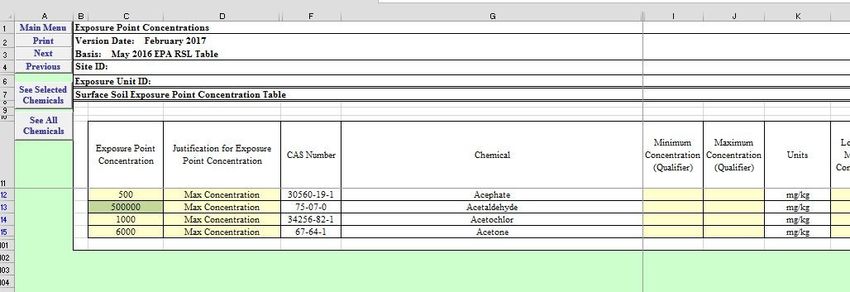
1.2      Risk Calculator Cell Color Codes

                                   Data entry field. All other cells are locked and cannot be changed
                                   by the user
                                   Non-volatile chemical*

                                   Soil concentration exceeds the soil saturation concentration, Csat

                                   Entry not required for pathways selected
                                   An entry has been modified from the default value, or no defaults
                     Red text      are established

                   * chemicals with a Henry's Law constant greater than or equal to 1 x 10⁻⁵ atm-
                   m3/mole or a vapor pressure greater than or equal to 1 mm Hg.

                           2.0      GATHERING SITE INFORMATION

2.1      Site Contamination

To assess risk of a site, the remedial investigation or
comprehensive site assessment must be complete, and the                        Contamination       that     is
following should be documented in a well-understood site                       demonstrated to be naturally
conceptual model:                                                              occurring should be included
                                                                               in the risk evaluation for risk
      1. Sufficient sampling to identify the type and extent of
         contamination in all media and the concentration trends               communication purposes.
         over time.
      2. Geology, hydrogeology, preferential flow paths, and other features influencing the
         movement of contaminants.
      3. The maximum concentration of each contaminant in each medium. Note, contaminants
         with concentrations demonstrated to be within naturally occurring background levels
         should be included in the initial risk evaluation and any unacceptable risk noted for
         communication purposes. Reasons for excluding naturally occurring contaminants from
         the risk evaluation must be well-documented. Cleanup of contaminants above naturally
         occurring levels is not required.
      4. Current and potential future receptors.
      5. Complete exposure pathways.

2.2      Exposure Pathways

An exposure pathway has five parts: a source of contamination, a transport mechanism (e.g.,
movement through groundwater), a point of exposure (e.g., a private well), a route of exposure
(oral, dermal, or inhalation), and a receptor population. When all five parts are present, the

February 2021                                            3                             Risk Calculator User Guide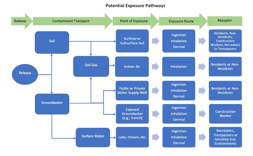
exposure pathway is termed a complete exposure pathway. Conversely, if an element in an
exposure pathway is missing or removed, through remediation or institutional controls, then the
pathway is rendered incomplete.
The user must identify the site-specific exposure pathways that are complete or may be expected
to become complete under current or reasonably anticipated future conditions (e.g., site or building
reconstruction or contaminant migration, etc.). The following graphic illustrates common
exposure pathways.
2.3 Receptors
Receptors may be human (children and adults in specific settings as described below), or
environmental (uncontaminated groundwater, surface waters, wetlands or sensitive environments).
Human receptors are represented by the following designated land uses:
Residential – Includes single-family homes, townhouses, apartment buildings, and
college/university dormitories. These are areas where both children and adults are
February 2021 4 Risk Calculator User Guideexpected to spend most of their time. Child/daycare facilities, schools through high school,
hospitals, and churches, are also considered residential.
Non-residential – Includes office buildings and commercial/industrial facilities where
adult workers routinely spend a significant part of their day. Colleges and universities
(excluding dormitories) are considered non-residential. Facilities whose chemical
exposures fall under the purview of the Occupational Safety and Health Administration
(OSHA) should have those risks evaluated separately. As stated in the DWM Vapor
Intrusion Guidance document, If OSHA standards currently govern the amount of chemical
allowed in indoor air, future exposures from subsurface contamination should be evaluated
using soil gas data to account for potential changes in use of the building or changes in
land use.
Construction Worker – Assumes that adult construction/utility workers may be exposed
to soils through large-scale redevelopment activities that disturb at least ½ acre of
contaminated soil. The associated exposure parameters assume a shorter exposure duration
and higher contamination exposure relative to residential and non-residential worker
scenarios. The additional particulate emission factor (PEF) and volatilization factor (VF)
equations are unique to this scenario.
Recreator – Assumes a total exposure time of 26 years, 6 years as a child (0 to 6 years
old) and 20 years as an adult (6 to 26 years old). With DWM approval, these exposure
durations can be adjusted for situations where a 26-year exposure duration would not be
feasible, such as 4-year housing rotations at a military base. This pathway is often only
complete at unsecured properties, undeveloped properties or properties with open space.
Trespasser –Assumes an exposure duration of 10 years (6 to 16 years old). This pathway
is often only complete at unsecured properties, undeveloped properties or properties with
open space.
2.4 Exposure Units
Exposure units are described as contaminated media within a site having similar concentrations,
exposures and use. Defining exposure units across a site allows evaluation of specific sub-areas
that may require a different set of engineered or institutional controls than other areas. Some
properties may be best evaluated as one exposure unit, providing that the user understands the
current and potential risks associated with the contaminated media across the entire property. Other
contaminated sites, such as those covering a large areal extent, may be best evaluated by dividing
the site into multiple exposure units. Refer to the example on the following page showing multiple
exposure units across a site and the current and potential future risks associated with each exposure
unit.
February 2021 5 Risk Calculator User GuideOnce the engineered and/or institutional controls are established across the site, the boundaries of
all restricted areas of the property must be physically discernable, surveyable, and shown on a
survey plat.
Example site with multiple Exposure Units.
A B
C
D
Potential
Water
Exposed Soil
Supply Well
Contamination
Industrial Building
Residences on
on Municipal Water Groundwater Contamination Municipal Water
Pathways and Receptors for Example Exposure Units
Contaminated
Exposure Unit Current/Future Receptor
Media
Current Non-residential Worker, Trespasser
Soil
Future Resident
A Groundwater Future Resident, Non-Residential Worker
Indoor Air Future1 Resident, Non-Residential Worker
Groundwater Potential Water Supply Well on
Future2
Migration Uncontaminated Property(ies)
Groundwater Future Resident and Non-Residential Worker
B Current Non-residential Worker
Indoor Air
Future1 Resident
Groundwater Future Resident and Non-Residential Worker
C
Indoor Air Future1 Resident and Non-Residential Worker
Groundwater Current Resident
D
Indoor Air Current Resident
1
When no suitable structures are present, future indoor air risk should be evaluated using soil gas data.
2
Contaminant migration modules in the calculator are used to predict movement of contaminants to a
known or hypothetical receptor (such as to a property where a water supply well may be installed).
February 2021 6 Risk Calculator User Guide3.0 USING THE RISK CALCULATOR
Download the latest version of the Risk Calculator from the Risk-Based Remediation Website.
Due to the complexity of the Risk Calculator, a few minutes may be needed to complete the
download. Once downloaded, the Risk Calculator opens to the “Main Menu” page. The entire
functionality of the Risk Calculator is displayed in the Main Menu page and is organized in four
general sections as shown below.
Optional project
information and
report-making
buttons
Links to
important
references and
VISLs
Exposure
pathway
selection, default
input values and
site-specific data
entry
Risk calculations
for each pathway
specified
Conservative
contaminant
migration
calculations
February 2021 7 Risk Calculator User Guide3.1 Project Information and Report Organization Section
This section is optional and includes sheets to add project information and prepare a report of key
risk assessment results with a cover page and table of contents.
3.1.1 Cover Page
The first button on the “Main Menu” takes the user to the “Cover Page” where the applicable site
and exposure unit information can be entered in the yellow data entry cells, where it is
automatically carried forward to the other sheets.
Shortcut buttons allow the user
to return to the main menu, or
proceed to the next sheet, or
previous sheet at any step.
The print button will print the
current sheet.
NCDEQ Risk Calculator date
and date of the EPA Regional
Cells for data entry are Screening Level table used in
highlighted yellow. All other the risk calculations.
cells are locked and can only
be edited by NCDEQ
Enter site information here.
The site ID and exposure unit
ID are automatically carried
forward to the other sheets.
February 2021 8 Risk Calculator User Guide3.1.2 Table of Contents
The “Table of Contents” sheet is optional. The check boxes are not linked to any other functions
in the Risk Calculator, so completion of this sheet has no effect on the risk assessment calculations.
Check boxes to compile
the report with the
pertinent sheets
(optional).
Site ID and Exposure Unit ID
must be entered on the Cover
Page in order to be carried
through to remaining sheets.
February 2021 9 Risk Calculator User Guide3.1.3 Select Sheets to Print Button
The “Select Sheets to Print” button is used to select the sheets to print in one batch. There is the
option to print individual sheets at each step in lieu of the batch print option. There is no option
in this window to select the printer. The correct printer should be selected through Excel’s
File>>Print menu.
Check the boxes to print the
desired sheets.
3.2 Site-Specific Data Input Section
This section contains multiple sheets for the user to enter the site-specific exposure pathways,
aquifer properties, and contaminant concentrations in each medium.
3.2.1 Complete Exposure Pathways
February 2021 10 Risk Calculator User GuideThe user should select the current and potential future exposure pathways identified as complete
in the conceptual site model by checking the pertinent boxes on the “Complete Exposure Pathways”
sheet. If a pathway is not checked, the risk assessment result will report “NC” (pathway
determined by user to be Not Complete) on the “Output Sheet”.
The common pathways
will automatically be
checked so should be
confirmed by the user.
Human Health
Risk Pathways.
Environmental
Risk Pathways
Human Health (Direct Contact) Pathway Considerations
Soil
Since surface soil contamination can pose a risk to all human receptors and deeper soil
contamination may only pose a risk to construction/utility workers, specific soil depth intervals
February 2021 11 Risk Calculator User Guidemay need to be evaluated separately. The selection of specific depth intervals should be
documented and justified.
Notes on the Construction Worker Scenario:
Construction-related exposures depend on many parameters, including the size of the site,
the size of the contaminated source area, the dimensions of the building(s) being
constructed and its location relative to the source area and to the site boundary, the type of
building being constructed (e.g., a slab-on-grade structure versus a building with a
basement), and the overall duration of the construction project. Because there is
uncertainty surrounding the details of future construction and the parameters can vary
considerably from project to project, USEPA does not provide RSLs for this pathway.
Emissions of both volatiles and particulate matter from contaminated soils increase the
inhalation risk to construction workers relative to that of other outdoor receptors. In some
cases, a higher risk could be calculated for a construction worker than for residential
receptors. As a result, the risk to construction workers should not drive a cleanup level but
be used to help guide safety concerns for imminent or potential future construction
activities. If a risk evaluation is warranted for a site-specific construction worker scenario,
the exposure parameters may be adjusted in the calculator with documented justification.
If further risk evaluation is warranted, e.g., for target organs, contact your program
representative so they can request assistance from a NCDEQ toxicologist.
Sediment
Sediment exposure is determined using the same equations and defaults as soil, so any sediment
data should be entered as soil. The user should consult with NCDEQ if modifications to the
exposure factors and contaminant migration parameters may be necessary to evaluate sediment
exposure.
Groundwater
The direct contact groundwater pathway calculates the risk
of using private well water for drinking, cooking and Risk-based groundwater remedies
bathing. To predict whether groundwater or a water supply must rely on institutional controls
well will become contaminated due to contaminant (a land-use restriction and/or a
notice on the property deed) that
migration, use the contaminant migration worksheets at the
bar water supply well installation
bottom of the Main Menu as further discussed below.
and groundwater use of any kind.
As a result, this direct contact (or
Evaluation of dermal contact with groundwater may be water supply use) pathway will be
needed to quantify risks associated with gardening, utility incomplete.
maintenance or digging at sites with shallow groundwater
February 2021 12 Risk Calculator User Guidetables. This pathway is not commonly evaluated under USEPA risk assessment guidance, so
contact your program representative so they can get assistance from a NCDEQ toxicologist if
groundwater exposure through digging beyond the water table is a concern.
Surface Water
The surface water pathway evaluates the risk for ingestion and
Surface water quality dermal (direct) contact of a recreator or trespasser exposed by
must meet the 15A NCAC wading or swimming in contaminated surface water. To predict
02B standards to be whether surface waters will become contaminated due to
eligible for No-Further- contaminant migration, use the contaminant migration worksheets
Action status. at the bottom of the Main Menu as further discussed below.
Potential ecological risks should be evaluated separately. Risk-
based site closure is not possible if contamination from the site discharges into surface waters at
levels that violate applicable surface water quality standards.
Vapor
The vapor intrusion pathway should be considered complete for
residential and non-residential receptors in structures overlying or The calculator should be
within 100 feet (vertical or horizontal) of contaminated soil or used to determine the
groundwater. Since the construction/utility worker will remain need for the next level of
outdoors, the vapor intrusion pathway is considered to be data in the vapor
incomplete. Consult the DWM Vapor Intrusion Guidance document intrusion evaluation.
for specific information pertaining to vapor intrusion.
Contaminant Migration Pathways
The calculator can evaluate three environmental pathways as shown in the graphic below:
1. Soil contaminants vertically leaching to groundwater and migrating to a downgradient
point. This downgradient point may be a water supply well, property boundary, sensitive
environment, or other point of interest. This distance can be set to zero to evaluate vertical
leaching only.
2. Groundwater contaminant migration to a specified downgradient point.
3. Contaminants in soil vertically leaching to groundwater and migrating downgradient to a
surface water body and becoming diluted by a known surface water discharge rate.
February 2021 13 Risk Calculator User Guide3.2.2 Exposure Factors and Target Risks The list of exposure parameters used in the Risk Calculator can be found in Appendix D of the Risk Evaluation Equations and Calculations. USEPA and NCDEQ default values are already populated on the Exposure Factors and Target Risks sheet shown below. Justifications for changing the default value must be documented in the “Justification” column and will require NCDEQ approval. February 2021 14 Risk Calculator User Guide
The target cancer risk and
                                                                      hazard index values are
                                                                        established in law.

                                                                             Red text alerts the
                                                                             user and reviewer
                                                                            that a default value
                                                                             has been changed.
                                                                            Space is provided to
                                                                             justify the change.

                                                                     Children are not
                                                                  considered trespassers,
                                                                  so cells are flagged as
                                                                    NA to prevent data
                                                                  entry for this scenario.

                                                                        Cells become grey when
                                                                      these values are not needed
                                                                       for the exposure pathways
                                                                      checked as complete on the
                                                                          “Complete Exposure
                                                                            Pathways” sheet.

If the “Recreator/Trespasser” pathway was selected as complete, the user must enter the
appropriate exposure parameters in the “Site Specific Value” column for the User-Defined Adult.
These receptors are not common and can only be run one at a time.

February 2021                                   15                       Risk Calculator User Guide
3.2.3 Contaminant Migration Parameters
Contaminant migration parameters are primarily related to geology/hydrogeology (porosity,
moisture content, hydraulic conductivity, hydraulic gradient, aquifer thickness, dry bulk density,
and fraction organic carbon) and plume dimensions (thickness, length, and width of soil and
groundwater source areas). Where a NCDEQ default value is not provided, a site-specific value
is required. A site-specific value entered in place of a default value will change the text color to
red. Justification for the change should be documented in the “Justification” column. If needed
parameters are not entered for a given pathway, the subsequent Output Forms will show “NM”
(Not Modeled). See the Risk Evaluation Equations and Calculations document for documentation
of the variables used.
If one or more “Contaminant
Migration Pathways” are
checked as complete, the
parameters needed will be
highlighted in yellow,
otherwise the cells will be gray.
February 2021 16 Risk Calculator User GuideWater filled soil porosity, air filled soil porosity, and fraction organic carbon have two default values, one for the soil to outdoor air pathway and one for the soil to groundwater pathway. If a site-specific value is entered, the user should enter the same value for both pathways. The default values given are considered conservative for the given pathway. To evaluate the groundwater to surface water pathway, the user must enter a site-specific groundwater to surface water seepage area (width and thickness) and a published surface water discharge rate. If there are no surface water flow data available from published reports or acquired measurements, then the user must use the default value of zero. The Risk Calculator will calculate a surface water concentration, compare it with the standard, and determine whether the standard has been exceeded. 3.2.4 Sample Statistics The optional “Sample Statistics” sheet is included to allow for basic statistical calculations of analytical data. This sheet is not linked to any other input or output sheets, and the data on this sheet is not carried forward in the risk assessment calculator. 3.2.5 Data Input - Exposure Point Concentrations For a given medium, risk will be calculated using one representative set of analytical results. The risk calculator does not accommodate multiple sample results or the spatial distribution of contamination in the evaluation of a selected pathway. Therefore, it is important that the data entered be the highest concentration of each detected chemical in the specific area and medium being evaluated (i.e., exposure unit). Both the chemical name and the CAS number can be searched in Excel. You may notice that if you select “Next” to advance to the next sheet in the calculator, an override sheet will appear. These sheets allow NCDEQ toxicologists to modify the February 2021 17 Risk Calculator User Guide
data entry according to the routes of exposure. They are not editable by the user and a pop-up
message will reflect that. Contact your remediation program representative if you would like a
NCDEQ toxicologist to assist you with site-specific exposure pathways.

                                              These optional columns
                                               are not used in the risk
                                              assessment calculations.

                           “See Selected Chemicals” reduces the list
                              of chemicals to only those where a
                                concentration has been entered.

Enter the maximum concentration of each detected contaminant as the “Exposure Point
Concentrations” for each affected media where a risk determination is desired, including:
   1. Contaminants detected at concentrations less than their residential Preliminary Soil
      Remediation Goal (PSRG), 15A NCAC 02L standard, or 15A NCAC 02B standard,
   2. Contaminant results flagged by the analytical lab, and
   3. Contaminants where the laboratory reporting limits were greater than the PSRGs, 15A
      NCAC 02L standards, or 15A NCAC 02B standards. Concentrations entered should be
      the lab’s reporting limit.

Example data input scenarios:

                          Laboratory Practical
                                                         Screening Level    Value to Enter in
 Maximum Detection         Quantitation Limit
                                                          (e.g., PSRG)         Calculator
                                (PQL)
          ND                      0.8                              1           Enter no value
          0.8                     0.5                              1                0.8
          0.8J                    0.5                              1                0.8
          ND                      1.5                              1                1.5

The “Justification” column can state the source of the data, e.g., boring or monitoring well ID.
These maximum concentrations are intended to be conservative and can represent either sitewide
conditions or a defined exposure unit. If the risk assessment indicates cumulative risks below
acceptable levels using sitewide maximum concentrations, then no further evaluation of multiple

February 2021                                       18                     Risk Calculator User Guide
exposure units is necessary. If cumulative risks exceed acceptable levels using maximum
concentrations, alternative and more representative average concentrations may be calculated as
discussed for each medium below.
If chemicals are eliminated as possible contaminants of concern, the lines of evidence for those
decisions should be appropriately documented and discussed in the risk assessment report. For
example, the contribution of background chemicals (detected at the site) to the overall site-wide
risk should be considered before eliminating background chemicals. If site contaminant
concentrations are in the range of background levels, the
initial risk calculations should include all contaminant
If the contaminant list is revised
concentrations. If risk is exceeded, further evaluation for subsequent calculator runs, all
would then consider the separate risk contributions of the associated sheets should be
site contaminants versus the background concentrations. “refreshed” by clicking “See All
While NCDEQ only requires clean up to background Chemicals” and then clicking
levels, the risk should be calculated from all contaminants “See Selected Chemicals”.
present, and the results may warrant additional risk
communication with suggestions for reducing risk if risk
levels are exceeded.
If a contaminant is not listed in the Risk Calculator, then contact your program representative so
they can request further guidance from a NCDEQ toxicologist.
Soil
An average soil contaminant concentration may be calculated in areas of consistent use (e.g.,
residential or industrial) and generally uniform release of contaminants (e.g., former waste lagoons,
spray fields, orchards, etc.), with the following considerations and the procedures documented:
No single sample point may exceed ten times the site-specific adjusted cleanup level for
all contaminants except lead. For lead, no single sample point used in an average may
exceed 1000 ppm for unrestricted-use and no more than three times the site-specific
cleanup level for restricted-use.
The quarter-acre zone may be a circle or a square or triangle of generally equal sides. One
dimension of the zone’s perimeter may not be disproportionately longer than another.
Samples must generally be evenly spaced over the zone of averaging.
Only samples of the same vertical horizon may be averaged (0-6 inches for surface samples
and no more than 5-foot vertical spread for subsurface samples.
Only actual sample data may be used for all points included in the average and not
published averages for background concentrations.
The laboratory practical quantitation limit (PQL) must be used for points where
concentrations are at or below lab reporting limits. Sample data should not be diluted or
elevated unnecessarily above normal reporting limits.
February 2021 19 Risk Calculator User GuideThe following chemicals have special data entry considerations when using the Risk Calculator:
Cadmium: Enter soil results as Cadmium (Diet). The state of NC uses the state 02L groundwater
standard as the protection of groundwater target, and this is incorporated into calculations for the
Protection of Groundwater PSRG. While EPA RSL tables have a slightly different approach, users
should enter cadmium soil values into Cadmium (diet) for Industrial, Residential, and Protection
of Groundwater assessment.
Chromium: Enter the speciated analytical results for Cr(III) and Cr(VI), if available. If only Total
Cr is reported, the result may only be entered as Cr(III) if it can be verified that Total Cr levels are
within natural background concentrations. Otherwise enter the Total Cr result as Cr(VI).
Cyanide: Enter the total cyanide result as the cyanide species that has the lowest residential
screening level in the PSRG Table (unless analyses for both total cyanide and specific species are
available to demonstrate all of the cyanide is of one particular species).
Dioxins and Furans: Multiply the individual dioxin and furan isomer results by their associated
toxicity equivalency factor (TEF) shown in the table below. Sum the adjusted concentrations of
all dioxins and furans and enter the result as 2,3,7,8-Tetrachlorodizenzo-p-dioxin (2,3,7,8-TCDD).
CASRN Dioxins and Furans TEF
Chlorinated dibenzo-p-dioxins
1746-01-6 2,3,7,8-TCDD 1
40321-76-4 1,2,3,7,8-PeCDD 1
39227-28-6 1,2,3,4,7,8-HxCDD 0.1
57653-85-7 1,2,3,6,7,8-HxCDD 0.1
57653-85-7 1,2,3,7,8,9-HxCDD 0.1
35822-46-9 1,2,3,4,6,7,8-HpCDD 0.01
3268-87-9 OCDD 0.0003
CASRN Dioxins and Furans TEF
Chlorinated dibenzofurans
51207-31-9 2,3,7,8-TCDF 0.1
57117-41-6 1,2,3,7,8-PeCDF 0.03
57117-31-4 2,3,4,7,8-PeCDF 0.3
70648-26-9 1,2,3,4,7,8-HxCDF 0.1
57117-44-9 1,2,3,6,7,8-HxCDF 0.1
72918-21-9 1,2,3,7,8,9-HxCDF 0.1
60851-34-5 2,3,4,6,7,8-HxCDF 0.1
35822-46-9 1,2,3,4,6,7,8-HpCDF 0.01
55673-89-7 1,2,3,4,7,8,9-HpCDF 0.01
39001-02-0 OCDF 0.0003
Lead: Currently there is no USEPA reference dose or cancer potency factor to quantify risks
associated with exposures to lead. Exposure risks to lead are characterized based on predicted
blood lead levels. The USEPA’s health-based screening levels for lead in soil are as follows:
February 2021 20 Risk Calculator User Guide Lead Compounds, residential soil exposure: The screening value for direct residential
contact is 400 mg/kg where it has been demonstrated the lead contribution from well water
is less than 5 ug/l.
Lead Compounds, combination of residential soil AND water exposure: The screening
value is 250 mg/kg for a residential scenario if there are untested drinking water wells in
use that are located in the area of lead contamination, or if the wells have been tested and
the tap water concentration is greater than 5 ug/l.
Lead Compounds, industrial/commercial soil exposure: The screening value is 800
mg/kg for an industrial/commercial scenario.
If either of these levels is exceeded, the Integrated Exposure Uptake Biokinetic (IEUBK) Model
for Lead in Children and the Adult Lead Methodology (ALM) may be used as appropriate to assess
the site-specific risks and calculate remedial levels. The USEPA has also developed the ALM for
evaluating the potential risks from lead in pregnant females. Refer to the USEPA lead guidance
for additional information.
Manganese: USEPA provides RSLs for both diet and non-diet. Enter the result as Manganese
(Non-diet), which excludes the dietary contribution from the normal US diet.
Mercury: Unless it is known what species of mercury is present at the site, enter the result as
‘Mercuric Chloride (and other Mercury salts)’. If methyl mercury formation or mercury vapor
inhalation is likely, contact DEQ for further guidance.
Nickel: Unless the release occurred in the last six months and it is clearly known which species
of this metal was released, enter the result as Nickel Soluble Salts.
Polychlorinated Biphenyls (PCBs): Enter results for the 12 individual dioxin-like PCB
congeners (listed below). Total the remaining 197 congener concentrations and enter the sum as
PCBs (high-risk). Do not enter results for Aroclors without first consulting with the appropriate
remediation program within NCDEQ.
IUPAC No. Dioxin-like PCB Congener
PCB-77 3,3’,4,4’-Tetrachlorobiphenyl
PCB-81 3,4,4’,5-Tetrachlorobiphenyl
PCB-105 2,3,3’4,4’-Pentachlorobiphenyl
PCB-114 2,3,4,4’,5-Pentachlorobiphenyl
PCB-118 2,3’,4,4’,5-Pentachlorobiphenyl
PCB-123 2’,3,4,4’,5-Pentachlorobiphenyl
PCB-126 3,3’,4,4’,5-Pentachlorobiphenyl
PCB-156 2,3,3’,4,4’,5-Hexachlorobiphenyl
PCB-157 2,3,3’,4,4’,5’-Hexachlorobiphenyl
PCB-167 2,3,4,4’,5,5’-Hexachlorobiphenyl
PCB-169 3,3’,4,4’,5,5’-Hexachlorobiphenyl
PCB-189 2,3,3’,4,4’,5,5’-Heptachlorobiphenyl
February 2021 21 Risk Calculator User GuideThallium: Unless the release occurred in the last six months and it is clearly known which species
of this metal was released, enter the result as Thallium (Soluble Salts).
Total Petroleum Hydrocarbons: Total petroleum hydrocarbon analyses for gasoline-range
organics, diesel-range organics, or select ranges of aliphatic and aromatic hydrocarbons do not
provide adequate information for risk analysis. For purposes of human health and ecological
risk evaluation, environmental matrices known or potentially contaminated with petroleum
hydrocarbons must be analyzed using USEPA Method 8260 for volatile organic compounds
(VOCs) and USEPA Method 8270 for semi-volatile organic compounds (SVOCs) to provide
compound-specific identification and entry into the calculator.
Groundwater
Due to the dynamic nature of groundwater conditions, the maximum historic concentration may
not be the most representative input concentration, nor will the most recent concentration. Overall
trends in groundwater concentration data should be considered on a site-specific basis when
selecting the input concentration. Safety factors may need to be considered in some cases.
Vapor
The calculator can evaluate current indoor air risks using any of the following data:
indoor air data
crawl space air data
sub-slab gas data
exterior soil gas data
groundwater data
Due to the variable construction characteristics of structures, risk to future structures on vacant
properties can only be calculated using exterior soil gas or groundwater data.
In all cases, maximum concentrations detected should be used as input concentrations. However,
if cumulative risks exceed acceptable levels using maximum concentrations, limited spatial and/or
temporal averaging may be allowed in some situations. Refer to the DWM Vapor Intrusion
Guidance document for additional details regarding gathering data for a proper vapor intrusion
evaluation.
3.3 Data Output Sheets
Each button in the “Data Output Sheet” in Sections 2 and 3 is a unique risk calculation for that
pathway. Before viewing the outputs for individual pathways, the calculator presents a summary
output of all pathways for a quick understanding of which pathways present an unacceptable risk.
February 2021 22 Risk Calculator User Guide3.3.1 Summary Output for All Calculators
The “Risk for Individual Pathways” presents the calculated risks for all the complete pathways
and allow the user to see which pathways exceed acceptable risk levels and may require further
evaluation and/or risk management. A “NC” result indicates that the pathway was Not Complete
because it was not checked as complete by the user.
NC=not complete.
The user did not Calculated
check this pathway as risk
complete
February 2021 23 Risk Calculator User Guide3.3.2 Direct Contact Soil and Water Calculators
This section provides details on the risk posed by each chemical in the complete exposure
pathways. An example output sheet is shown for soil below.
Shaded cells are the
Concentrations carried over from calculated risk for
input sheet. Will be the same for
individual chemicals.
each route of exposure unless
approved by a NCDEQ Bold values indicate a risk
toxicologist. exceedance.
Cumulative risk from this pathway.
An unacceptable risk will be bold.
The calculated risks for each route of entry is shown in the gray cells and summed in the white cell
to the right. Target risks for individual chemicals are 1x10⁻⁶ for carcinogens and a 0.2 for
noncarcinogens. The individual risks are summed to determine the cumulative risks for each
receptor. Cumulative risks for each receptor are then compared to a risk of 1x10⁻⁴ for carcinogens
and 1 for noncarcinogens.
For evaluation of outdoor inhalation risks due to contaminated soils, two additional parameters are
incorporated into the calculations: the volatilization factor (VF) and particulate emission factor
February 2021 24 Risk Calculator User Guide(PEF). The VF is calculated using both the unlimited source and mass limit equations and the VF
yielding the higher risk value is carried through in the final output. The PEF is used to evaluate
outdoor inhalation of particulates by incorporating dispersion constants. The USEPA RSL website
provides default values for the dispersion constants for different geographic locations. The Risk
Calculator uses a default dispersion constant recommended by USEPA for Raleigh, NC. Since
construction activities vary greatly from site to site, USEPA does not provide default inputs for
the construction worker scenario. North Carolina has chosen very conservative default inputs that
represent worst case situations and may result in overly restrictive risk values in the majority of
cases. Therefore, the construction worker pathway should only be evaluated when large
construction activities are possible. Refer to the construction worker assumptions in Section 3.2.1.
3.3.3 Vapor Intrusion
Calculators
The Risk Calculator now
includes links to the DWM
vapor intrusion screening
levels. Users that have
screening level exceedances
are directed to enter the data
into the calculator to calculate
risk. It is DWM policy that vapor mitigation decisions be based on risk and not on a screening
level exceedance. Therefore, it is important that users follow the North Carolina Division of Waste
Management Vapor Intrusion Guidance document.
The “Vapor Intrusion Calculators” evaluate risk
associated with indoor inhalation of contaminated
vapor intruding into a structure from subsurface The Risk Calculator does not include a
calculation for soil to indoor air due to
contamination. Vapor intrusion risk can be calculated
challenges associated with modeling
for a resident or a non-residential worker using either
vapor intrusion for soil sources. If
indoor air data, soil gas data, or groundwater data, impacted soil is present beneath or
depending on the site-specific data availability. The adjacent to a building, sub-slab gas,
calculations for indoor air are based on the equations crawl space, and/or indoor air samples
specified on the USEPA RSL website and NCDEQ- should be collected.
approved input parameters. The calculations for soil
February 2021 25 Risk Calculator User Guidegas and groundwater to indoor air are based on the equations specified on the USEPA Vapor
Intrusion Screening Level (VISL) Calculator using NCDEQ-approved default parameters. An
overview of the risk characterization approach used in each calculator is summarized as follows:
Site-specific indoor air concentrations are compared the USEPA screening levels to
calculate the risk for each individual constituent, then the risks for individual constituents
are summed to calculate the cumulative risk.
For the soil gas to indoor air calculator, soil gas concentrations are multiplied by an
attenuation factor of 0.01 for the non-residential calculator and 0.03 for the residential
calculator to predict indoor air concentrations. Cumulative risks are then calculated for the
predicted indoor air concentrations using the same process as the indoor air calculator.
For the groundwater to indoor air calculator, groundwater concentrations are multiplied by
Henry’s Law Constant to predict soil gas concentrations, then multiplied by an attenuation
factor of 0.001 (same for residential and non-residential), and then multiplied by a 1,000
L/m3 conversion factor to predict indoor air concentrations. Cumulative risks are then
calculated for the predicted indoor air concentrations using the same process as the indoor
air calculator.
An example vapor intrusion output sheet is shown below.
Orange cells indicate
the chemical is non-
volatile.
Note that the NCDEQ Risk Calculator does not allow modification of the residential VI
exposure duration for mutagens and conservatively applies a default of 26-years regardless of
the site-specific exposure duration entered into the calculator. Consult with a NCDEQ
February 2021 26 Risk Calculator User Guidetoxicologist if you need to adjust exposure parameters at a site with one of the following
mutagenic contaminants.
List of Mutagenic Contaminants
Chemical CASRN Reference
Acrylamide 79-06-1 IRIS
Benz[a]anthracene 56-55-3 Benzo[a]pyrene*
Benzidine 92-87-5 Supplemental Guidance
Benzo[a]pyrene 50-32-8 Supplemental Guidance
Benzo[b]fluoranthene 205-99-2 Benzo[a]pyrene*
Benzo[k]fluoranthene 207-08-9 Benzo[a]pyrene*
Chromium(VI) 18540-29-9 CalEPA and IRIS
Chrysene 218-01-9 Benzo[a]pyrene*
Coke Oven Emissions 8007-45-2 70 Federal Register 19992
Dibenz[a,h]anthracene 53-70-3 Supplemental Guidance
Dibromo-3-chloropropane, 1,2- 96-12-8 PPRTV
Dimethylbenz(a)anthracene, 7,12- 57-97-6 Supplemental Guidance
Ethylene Oxide 75-21-8 IRIS
Indeno[1,2,3-cd]pyrene 193-39-5 Benzo[a]pyrene*
Methylcholanthrene, 3- 56-49-5 Supplemental Guidance
Methylene Chloride 75-09-2 IRIS
Methylene-bis(2-chloroaniline), 4,4'- 101-14-4 PPRTV
Nitrosodiethylamine, N- 55-18-5 Supplemental Guidance
Nitrosodimethylamine, N- 62-75-9 Supplemental Guidance
Nitroso-N-ethylurea, N- 759-73-9 Supplemental Guidance
Nitroso-N-methylurea, N- 684-93-5 Supplemental Guidance
Safrole 94-59-7 Supplemental Guidance
Trichloroethylene 79-01-6 IRIS
Trichloropropane, 1,2,3- 96-18-4 IRIS
Urethane 51-79-6 Supplemental Guidance
Vinyl Chloride 75-01-4 Supplemental Guidance
3.3.4 Sitewide Human Health Risk Summary
The calculator computes the total risks of all contaminants for each pathway in each medium
individually. To ensure that all site risks are within the allowable limits, a Sitewide Risk Summary
February 2021 27 Risk Calculator User GuideSheet has been developed within the calculator to sum the risks of all pathways. The user selects
the pathways that are complete, similar to the “Complete Exposure Pathways” sheet.
The vapor intrusion risk can be calculated by using either groundwater, soil gas or indoor air data.
The calculator’s sitewide risk summary sheet is designed to consider only one vapor risk
calculation, so the inhalation risk will not be overestimated.
The user selects the
pathways that will remain
complete following the
use of engineered or
institutional controls, i.e.
those to be summed.
The calculator only
allows one set of vapor
data to be checked so
the vapor risk is not
double counted.
When risk from any contaminated media is exceeded, it is up to the risk manager on how to best
mitigate those risks through remediation, engineered controls and/or institutional controls.
3.4 Contaminant Migration Worksheets
The contaminant migration equations predict contaminant concentrations at a specified distance
that have migrated from a known source concentration. Three transport equations are included in
the Risk Calculator: (i) soil leaching to groundwater, (ii) groundwater migration to a potential
February 2021 28 Risk Calculator User Guideexposure point, and (iii) surface water dilution. The Risk Evaluation Equations and Calculations
are accessible on the Risk-Based Remediation website.
When only the default
3.4.1 Soil Leaching to Groundwater Calculations
parameters are used, the
result will be close to the
The soil leaching to groundwater calculations are based on Protection of Groundwater
methodology presented in the USEPA Soil Screening Guidance PSRG.
(USEPA, 1996) and USEPA Supplemental Guidance for
Developing Soil Screening Levels for Superfund Sites (USEPA, 2002). These equations are also
used to develop the Protection of Groundwater PSRGs. The equations predict a groundwater
concentration based on source area soil concentration. If “0 feet” is entered for the distance to the
POE on the “Contaminant Migration Parameters” sheet, the calculator will only consider vertical
leaching to groundwater to predict the groundwater concentration directly beneath the soil source
area. A distance greater than zero will also include the lateral transport equation described in the
next section.
The assumptions used in the leaching equation are depicted in the USEPA graphic below:
• Infinite source (i.e., steady-state concentrations are maintained over the exposure period).
• Uniformly distributed contamination from the surface to the top of the aquifer.
• No contaminant attenuation (i.e., adsorption, biodegradation, chemical degradation) in soil.
• Instantaneous and linear equilibrium oil/water partitioning.
• Unconfined, unconsolidated aquifer with homogeneous and isotropic hydrologic Properties.
• Receptor well at the downgradient edge of the source and screened within the plume.
• No contaminant attenuation in the aquifer.
• No NAPLs present (if NAPLs are present, the SSLs do not apply).
February 2021 29 Risk Calculator User GuideTwo equations are available for soil leaching to groundwater, (i) unlimited source model for chronic exposure and (ii) mass limit model for chronic exposure. Per the USEPA Soil Screening Guidance, the unlimited source model assumes an infinite source, so it may violate mass-balance considerations, especially for small sources. As a result, the USEPA guidance also specifies a mass limit equation that may be used when the depth of the contaminated soil source is known or can be estimated with confidence. Also, per the USEPA Soil Screening Guidance, screening levels are calculated using both the unlimited source equation and the mass limit equation. The higher screening level is then used for subsequent modeling calculations. To determine default infiltration rates, an evaluation was performed by the NCDEQ Dry Cleaning Program at 20 sites that were selected to be representative of different geological and weather conditions across NC. For each site, the USEPA’s Hydrologic Evaluation of Landfill Performance (HELP) Model Version 3.07 was used to calculate infiltration rates as a percentage of precipitation. Based on review of the spatial distribution of the calculated infiltration rates, default infiltration rates were selected for different geographic zones across the State of North Carolina. A description of each zone and recommended default infiltration rates to be applied to each zone are summarized below: • Mountain Zone (includes Blue Ridge and Western Piedmont belts) – 30% of precipitation • Piedmont Zone (includes Eastern and Central Piedmont belts) – 25% of precipitation • Coastal Plain Zone (includes Inner and Outer Coastal Plain belts) – 45% of precipitation February 2021 30 Risk Calculator User Guide
The user should determine average precipitation in the site area using published references, then
multiply the precipitation value by the infiltration percentage applicable to the site’s geographic
zone to calculate the infiltration rate to be input.

Infiltration rates should represent source areas with no surface cover in order to confirm whether
an engineered surface cover is warranted to prevent future leaching of soil contaminants.

3.4.2   Groundwater Migration Calculations

Groundwater migration is calculated using the Domenico model [Domenico and Robbins (1985)
and Domenico (1987)]. This one-dimensional model is recognized by USEPA and is the
recommended modeling equation in the ASTM Standard Guide for Risk-Based Corrective Action
at Petroleum Release Sites (ASTM, 2002). This methodology is used to predict the steady-state
groundwater concentration at a specified downgradient distance from a source area accounting for
advection and dispersion. Dispersivity values are calculated based on the user-specified migration
distance using equations specified in the ASTM guidance (ASTM, 2002). The Risk Calculator
conservatively assumes no chemical degradation.

Source soil or groundwater contaminant concentrations are used to estimate the concentrations of
each contaminant in groundwater at the specified distance. The calculated groundwater
concentrations are compared with the 15A NCAC 02L standards to determine if the standards are
exceeded. Because this is a simple, 1-D model, it should only be used as a screening tool.

            Due to the simplicity of the transport equations, empirical monitoring data that
            confirm the plume is stable and unlikely to impact a downgradient receptor are
            more reliable to support risk management decisions.

3.4.3   Surface Water Dilution Calculations

To predict the contaminant concentrations in a surface water receptor, the calculator first employs
the leaching and/or lateral transport equations to predict the groundwater concentrations at the
surface water location. The user-specified plume thickness and width are used to calculate the
volume of groundwater entering the surface water body to calculate the surface water dilution
factor. The surface water dilution factor is applied only if the surface water flow rate is known or
measured, otherwise, no surface water dilution is assumed.

February 2021                                        31                         Risk Calculator User Guide
You can also read