BIOLOGICAL RESOURCES REPORT - FOCUSED SURVEY FOR AGASSIZ'S DESERT TORTOISE, HABITAT ASSESSMENTS FOR BURROWING OWL & MOHAVE GROUND SQUIRREL ...
←
→
Page content transcription
If your browser does not render page correctly, please read the page content below
BIOLOGICAL RESOURCES REPORT
& FOCUSED SURVEY FOR AGASSIZ’S DESERT TORTOISE,
HABITAT ASSESSMENTS FOR BURROWING OWL &
MOHAVE GROUND SQUIRREL

1555 WILD ROSE ROAD, TRONA, INYO COUNTY, CALIFORNIA
15-ACRE± SITE APN 038-300-07-00

APRIL 2021

BIOLOGICAL RESOURCES REPORT
           & FOCUSED SURVEY FOR AGASSIZ’S DESERT TORTOISE,
 HABITAT ASSESSMENTS FOR BURROWING OWL & MOHAVE GROUND SQUIRREL

           1555 WILD ROSE ROAD, TRONA, INYO COUNTY, CALIFORNIA
                       15-ACRE± SITE APN 038-300-07-00

    U.S. GEOLOGICAL SURVEY 7.5’ TRONA EAST QUADRANGLE, TOWNSHIP 24
          SOUTH, RANGE 43 EAST, A PORTION OF SECTION 28, S.B.B.&M

                                   PREPARED BY:

                      GEŌDE ENVIRONMENTAL INC.
                          ESSRA MOSTAFAVI, MA
           AUTHOR AND FIELD INVESTIGATOR: EDWARD L. LARUE, JR.,

                           684 AUTUMN LEAVES CIRCLE
                            BISHOP, CALIFORNIA 93514
                                  760.428.8068
                   EMAIL: INFO@GEODEENVIRONMENTAL.COM

I hereby certify that the statements furnished herein, including attached exhibits,
present the data and information required for this biological evaluation, and that the
facts, statements, and information presented are true and correct to the best of my
knowledge and belief. Field work conducted for this assessment was performed by me
or under my direct supervision. I certify that I have not signed a nondisclosure or
consultant confidentiality agreement with the project applicant or applicant’s
representative and that I have no financial interest in the project.

                                                                    1   |
TABLE OF CONTENTS
EXECUTIVE SUMMARY.……...………………………………………………………...…..…..4
FIGURE 1. SITE LOCATION MAP .................................................................................................6
FIGURE 2. SITE MAP WITH TRANSECT LOCATIONS ..................................................................7
FIGURE 3. AERIAL PHOTOGRAPH ..............................................................................................8
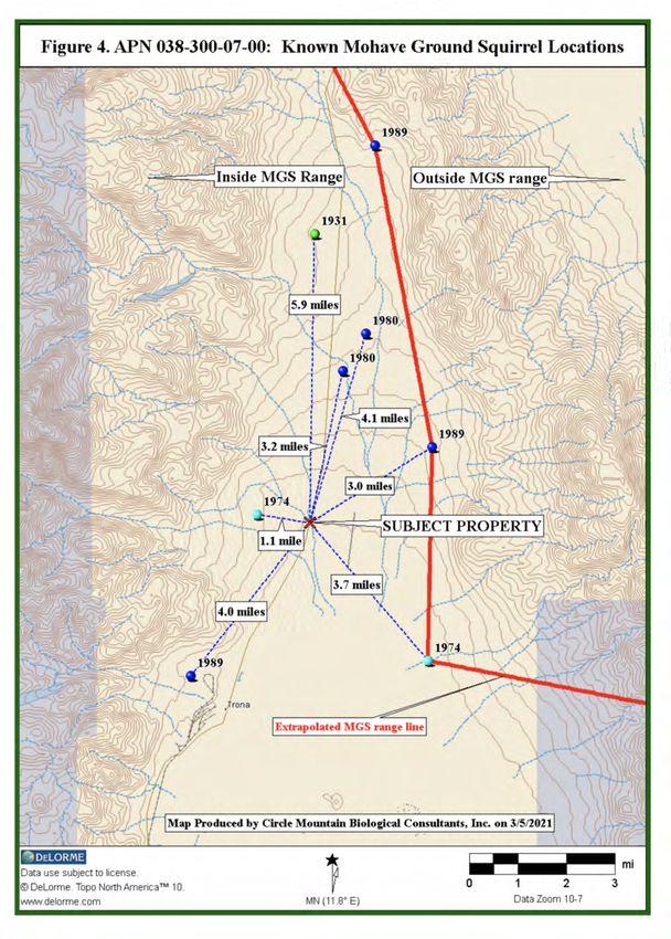
FIGURE 4. KNOWN MOHAVE GROUND SQUIRREL LOCATIONS .............................................9
1.0. INTRODUCTION ....................................................................................................10
1.1. Purpose & Need For Study .....................................................................................10
1.2. Project Description...................................................................................................10
2.0. METHODS...............................................................................................................11
2.1. Literature Review......................................................................................................11
2.2. Field Survey .............................................................................................................11
2.2.1 Survey and Habitat Assessment Protocols……………….…….………...…..11
2.2.2 Field Survey Methods……………………………………………..………...….12
3.0. RESULTS .................................................................................................................13
3.1. Common Biological Resources.................................................................................13
3.1.1. Common Flora ..........................................................................................14
3.1.2. Common Fauna ........................................................................................14
3.2. Uncommon Biological Resources.............................................................................15
3.2.1. Agassiz’s Desert Tortoise ...........................................................................15
3.2.2. Other Special Status Species ....................................................................16
3.3. Other Protected Biological Resources .....................................................................19
3.3.1. Stream Courses .........................................................................................19
3.3.2. Protected Plant Species ............................................................................19
4.0. CONCLUSIONS & RECOMMENDATIONS ............................................................20
4.1. Impacts To Agassiz’s Desert Tortoise & Proposed Mitigation..................................20
4.2. Impacts To Other Biological Resources & Proposed Mitigation………………....…..21
4.2.1. Other Special Status Species.....................................................................21
4.2.2. Other Protected Biological Species ..........................................................21
4.2.2.a. Stream Courses ………………………..............................21
4.2.2.b. Protected Plants………………………..............................22
4.2.2.c. Bird Nests ………..……………………..............................22
2 |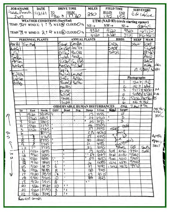
5.0. REFERENCES .......................................................................................................23
APPENDIX A. Plant Species Detected .....................................................................................26
APPENDIX B. Animal Species Detected ..................................................................................28
APPENDIX C. Field Data Sheet Completed On 2 March 2021 ...............................................29
APPENDIX D. Photographic Exhibits (See Figure 5 For Exhibit Locations) .............................31

                                                                                                   3   |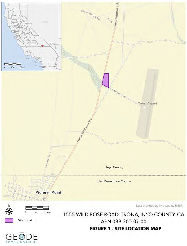
EXECUTIVE SUMMARY

This Biological Resources Report has been prepared to support Inyo County's
California Environmental Quality Act (CEQA) environmental document findings related
to biological resources for the Pinnacle Growth Inc., cannabis cultivation project. In
addition to a general biological resource assessment, this report includes a focused
survey for Agassiz’s desert tortoise (DT), and habitat assessments for burrowing owl and
Mohave ground squirrel (MGS).

The Pinnacle Growth Inc. project is located on a 15-acre± segment of 80-acre Inyo
County APN 038-300-07, located at 1555 Trona Wildrose Road, Trona, CA (see Figures
1 and 2). The project area is located east of Trona Wildrose Rd. and north of Trona
Airport Rd. The legal description for the subject property is Township 24 South, Range
43 East, a portion of Section 28, S.B.B.&M.

For a total of 5.0 hours, between 10:15 and 15:15 hours on March 2, 2021, Ed LaRue
surveyed the site and adjacent areas as described herein. This entailed a survey of 40
transects, spaced at 10-meter intervals and oriented in an east-west direction
throughout the 15-acre± parcel. As depicted in Figure 2, 10 zone of influence transects
were surveyed for detection of burrowing owls at 30-meter intervals to the north and
east, and were not performed to the south or west due to lack of habitat on fenced
private parcels.

Based on DeLorme Topo USAÒ 10.0 software, elevations on the subject property
range from approximately 1,700 feet (518 meters) at the northwest corner down to
1,685 feet (513 meters) at the southeast corner. Terrain is flat, soils are sandy, and in
many places compacted from years of heavy human uses. A single, barely-perceptible
USGS-designated blueline stream occurs on the southern portions of the site. The 35
common plant species identified during the survey, including 28 species onsite and 6
species in adjacent areas, are listed in Appendix A. The site has been heavily impacted
by human use, so about half of it is barren and semi-barren, and the other half is
vegetated by degraded saltbush scrub. Seven of the 34 plant species (20%) are not
native to California. The one reptile, three bird, and six common mammal species
identified during the survey are listed in Appendix B.

Based on the absence of tortoise sign onsite and in adjacent areas, and available
information reviewed for this habitat assessment, Ed LaRue concludes that tortoises are

                                                                      4   |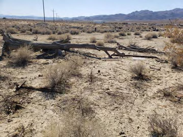
absent from the subject property. As such, no impacts are anticipated and no
mitigation measures are recommended.

Based on the field survey and habitat assessment, Ed Larue concludes that none of the
following special status species reported from the region will be adversely affected by
site development: Crucifixion thorn, burrowing owl, prairie falcon, American badger, kit
fox, or Nelson’s bighorn sheep. As such, no adverse impacts have been identified and
no mitigation measures are recommended.

Although a focused Mohave ground squirrel trapping survey was not performed, Ed
LaRue assessed habitats and reviewed available information to provide a professional
opinion as to the presence or absence of this species on the subject property. Given
the information discussed herein, Ed LaRue concludes that habitat loss, degradation
onsite, and isolation of the site due to lack of habitats to the west and south have
significantly diminished the likelihood of occurrence. Ed LaRue therefore concludes
that Mohave ground squirrel is likely absent from the site and that protocol trapping
surveys are not warranted. The County and/or CDFW will need to concur with this
determination (or not) before the conclusion and decision not to trap are considered
final.

As given herein, there are no biological components like mesic-adapted plant species
that differentiate a USGS-designated blueline stream on the southern portion of the
site from surrounding upland areas. The County will need to determine if a Streambed
Alteration Agreement is warranted for site development.

A single desert holly plant is the only species found on-site that may be subject to
pertinent development codes under the California Native Plant Protection Act. It is
located in semi-barren areas where its protection would not substantially benefit local
floral resources.

                                                                      5   |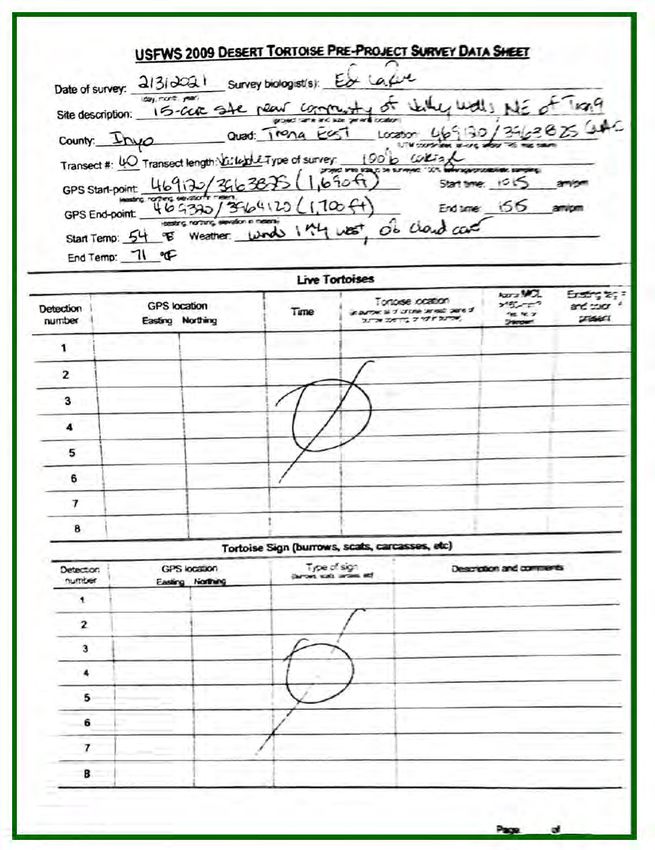
6 |
7 |
8 |
9 |
1.0 INTRODUCTION

1.1. Purpose & Need for Study

This Biological Resources Report has been prepared to support Inyo County's California
Environmental Quality Act (CEQA) environmental document findings related to biological
resources for the Pinnacle Growth Inc., cannabis cultivation project. In addition to a general
biological resource assessment, this report includes a focused survey for Agassiz’s desert
tortoise (Gopherus agassizii), and habitat assessments for burrowing owl (Athene cunicularia)
and Mohave ground squirrel (Xerospermophilus mohavensis).

Given the location of the site in an unincorporated portion of the county and because Inyo
County does not have specific guidelines for biological reports, this report has been prepared,
in part, according to County of San Bernardino’s Report Protocol for Biological Assessment
Reports (County of San Bernardino 2006).

As the California Environmental Quality Act (CEQA) Lead Agency, Inyo County Planning
Department (County) is required to complete an Initial Study to determine if site development
will result in any adverse impacts to rare biological resources. The information may also be
useful to federal and State regulatory agencies, including U.S. Fish and Wildlife Service
(USFWS) and California Department of Fish and Wildlife (CDFW), respectively, if the Lead
Agency asks them to assess impacts associated with proposed development. Results of the
focused tortoise survey, burrowing owl, and Mohave ground squirrel habitat assessments; and
general biological resource assessment, are intended to provide sufficient baseline information
to these agencies to determine if significant impacts will occur and to identify mitigation
measures, if any, to offset those impacts.

1.2. Project Description

The Pinnacle Growth Inc. project is located on a 15-acre± segment of 80-acre Inyo County
APN 038-300-07, located at 1555 Trona Wildrose Road, Trona, CA. The project area is located
east of Trona Wildrose Rd. and north of Trona Airport Rd. The legal description for the subject
property is Township 24 South, Range 43 East, a portion of Section 28, S.B.B.&M.

The California Bureau of Cannabis Control (BCC), the agency regulating commercial cannabis
licenses, has issued Pinnacle Growth Inc. a Type 12 Microbusiness license (License Number
5E-001) allowing for Indoor Cultivation greater than 5,000 sqft, distribution, Manufacturing
Level 1 (type 6 non-volatile), and Manufacturing Level 2 (Type 7 volatile extraction).

                                                                          10   |
The project will be developed in 4 phases:
● Phase 1- Development of 2,300 sq ft small buildings for the nursery and a larger
2,300 sq ft greenhouse for the mother plants.
● Phase 2- Will consist of a large 10,000 sq ft greenhouse for cultivation. Wholesale
distribution and non-storefront delivery will also begin in Phase 2.
● Phase 3- The addition of five 10,000 sq ft greenhouses increasing cultivation output.
● Phase 4- The addition of manufacturing level 1( Type 6 non-volatile) and
manufacturing level 2 (Type 7 volatile) labs for infusing products and for concentrate
production.
2.0. METHODS
2.1. Literature Review.
Biological data repositories like the California Natural Diversity Database (CNDDB), an
inventory of the status and locations of rare plants and animals in California, was consulted to
determine the nearest tortoise locations and other special status plant and animal species that
have been reported from the vicinity of the subject property. The primary source of information
was taken from the March 2021 version of the CNDDB (CNDDB; CDFW 2021a). This and other
materials used in the completion of this report are listed in Section 5.0, below.
2.2. Field Survey.
2.2.1. Survey and Habitat Assessment Protocols
A significant paper was published in June 2011 (Murphy et al. 2011) whereby the “desert
tortoise” of the Mojave Desert was split into two species, including Gopherus agassizii, referred
to as “Agassiz’s desert tortoise,” and a newly described species, G. morafkai, referred to as
“Morafka’s desert tortoise,” which occurs in the Sonoran Desert. According to Murphy et al.
(2011), “…this action reduces the distribution of G. agassizii to only 30% of its former range.
This reduction has important implications for the conservation and protection of G. agassizii,
which may deserve a higher level of protection.” Then in 2016 (Edwards et al. 2016), a third
species of tortoise was described, referred to as the “Goode’s Thornscrub Tortoise” (Gopherus
evgoodei), which further reduced the perceived range of Morafka’s desert tortoise. Agassiz’s
desert tortoise is the threatened species that occurs in the region surrounding the subject
property.
11 |For Agassiz’s desert tortoise, Ed LaRue followed the presence-absence survey protocol first
developed by the USFWS in 1992 and recently revised in 2019. USFWS (2019) protocol
recommends surveying transects at 10-meter (30-foot) intervals throughout all portions of a
given parcel and its associated action area. The action area is defined by regulation as all areas
to be affected directly or indirectly by proposed development and not merely the immediate
area involved in the action (50 CFR §402.02). For this site, the action area is considered to be
the same as the subject property. Since the site is smaller than 500 acres, it may be surveyed
year-round and there is no opportunity to estimate the density of tortoises on the 15-acre±
subject property (USFWS 2019), as no tortoise sign was found.
For burrowing owl, although the formal habitat assessment does not specify a given interval to
survey a site (Appendix C in CDFG 2012), subsequent breeding and nonbreeding studies
identify that transects are surveyed at 7 to 20 meters (23 to 65 feet) apart, with five additional
transects surveyed at 30-meter intervals out to 150 meters (500 feet) in adjacent areas in
potential habitat (i.e., excluding areas substantially developed for commercial, residential,
and/or industrial purposes) (Appendix D in CDFG 2012). With its narrower transect intervals,
the tortoise survey is sufficient to cover the site for burrowing owls. The focus of the survey is to
find and inspect all burrows sufficiently large to be used by burrowing owls. Importantly, this
methodology is considered a formal habitat assessment for the presence of burrowing owls,
which can be conducted any time of the year. Had burrowing owl signs been found, which it
was not, it would have then been necessary to perform breeding burrowing owl surveys during
the spring and summer as outlined in CDFG (2012).
For Mohave ground squirrels, some jurisdictions require that habitat assessments be performed
by individuals certified by CDFW for trapping the species. Ed LaRue, who performed the
fieldwork and drafted this assessment, possesses a Mohave ground squirrel Memorandum of
Understanding with CDFW, dated January 21, 2020 as an attachment to scientific collecting
permit (SC-001544), which expires on December 31, 2022. The primary assessment herein asks
the following questions: (1) Is the site within the range of the species?; (2) Is there native habitat
with a relatively diverse shrub component?; And, (3) is the site surrounded by development and
therefore isolated from potentially occupied habitat?
2.2.2. Field Survey Methods
For a total of 5.0 hours, between 10:15 and 15:15 hours on March 2, 2021, Ed LaRue surveyed
the site and adjacent areas as described herein. This entailed a survey of 40 transects, spaced
at 10-meter intervals and oriented in an east-west direction throughout the 15-acre parcel. As
depicted in Figure 2, 10 zone of influence transects were surveyed for detection of burrowing
owls at 30-meter intervals to the north and east, and were not performed to the south or west
12 |due to lack of habitat on fenced private parcels. Copies of data sheets completed in the field
and USFWS’ (2019) pre-project survey data sheet are included in this report (see Appendix C).
As the site was surveyed, LaRue kept tallies of observable human disturbances encountered on
each of the transects he surveyed. The results of this method provide encounter rates for
observable human disturbances. For example, two roads observed on each of 10 transects
would yield a tally of 20 roads (i.e., two roads encountered 10 times). Habitat quality, adjacent
land uses, and this disturbance information are discussed below in Section 3.2 relative to the
potential occurrence of Agassiz’s desert tortoise and other special status species on and
adjacent to the subject property.
Weather conditions recorded at the beginning and ending of the survey included temperatures
measured approximately 5 centimeters (2.0 inches) above the ground, percent cloud cover, and
wind speeds measured by a hand-held Kestrel weather and wind speed meter, as reported in
Table 1.
All plant and animal species identified during the survey were recorded in field notes. A
Garmin hand-held, global positioning system (GPS) unit was used to survey straight transects
and record Universal Transverse Mercator (UTM) coordinates (North American Datum – NAD
83) for property boundaries, rare species locations, and other pertinent information (Appendix
C). A digital camera was used to take representative photographs (Appendix D), with locations
and directions of exhibits shown in Figure 5. ©2021GoogleTM Earth was accessed via the
internet to provide recent aerial photographs of the subject property and surrounding areas
(Figure 4).
3.0. Results
3.1. Common Biological Resources
The common plant and animal species identified during the survey are listed in Appendices A
and B, respectively. Based on DeLorme Topo USA 10.0 software, elevations on the subject
property range from approximately 1,700 feet (518 meters) at the northwest corner down to
1,685 feet (513 meters) at the southeast corner. Terrain is flat, soils are sandy, and in many
places compacted from years of heavy human uses. A single, barely-perceptible
USGS-designated blueline stream occurs on the southern portions of the site.
13 |3.1.1. Common Flora
The 35 common plant species identified during the survey, including 28 species onsite and 6
species in adjacent areas, are listed in Appendix A. The plant community onsite is best
characterized as saltbush scrub, where allscale (Atriplex polycarpa), spiny saltbush (Atriplex
confertifolia), and burrobush (Ambrosia dumosa) are the codominant species. Less abundant
species include individual creosote bush (Larrea tridentata), cheesebush (Ambrosia salsola), and
Torrey’s sea-blight (Suaeda nigra).
The site has been heavily impacted by human uses. A local resident indicated that the site was
used off-and-on as a motocross race track since the 1970’s. This longtime use has resulted in
pits (Exhibit 3), compacted soils (Exhibit 7), and there are picnic structures (Exhibits 4 and 5),
benches (Exhibit 6), and extensive piles of metal debris throughout the site resulting from these
historic uses. As mapped in Figure 2, about half of the site is barren and semi-barren (see the
top aerial in Figure 4, which was taken in 2014), and the other half is vegetated by degraded
saltbush scrub. Seven of the 34 (20%) plant species are not native to California. The presence
of Russian thistle (Salsola tragus), London rocket (Sisymbrium irio), tumble mustard (Sisymbrium
altissimum), and flixweed (Descurainia sophia) are all indicators of highly degraded habitats,
and would not be present in pristine or even less-degraded desert areas.
3.1.2. Common Fauna
Appendix B lists the species identified during the surveys: one reptile, three birds, and six
common mammal species. The one reptile species observed, the common side-blotched lizard
(Uta stansburiana), is an indication of the relatively early survey period during cooler
temperatures. Other locally common reptile species that occur in the region and possibly
onsite include zebra-tailed lizard (Callisaurus draconoides), long-nosed leopard lizard
(Gambelia wislizenii), desert horned lizard (Phrynosoma platyrhinos), red racer (Masticophis
flagellum), glossy snake (Arizona elegans), gopher snake (Pituophis melanoleucus), long-nosed
snake (Rhinocheilus lecontei), and various rattlesnake species (Crotalus ssp.), though habitat
degradation may preclude some from occurring.
Only three bird species were observed, including common raven (Corvus corax), sage thrasher
(Oreoscoptes montanus), and Say’s phoebe (Amphispiza belli), all of which are tolerant of
human development. Both ravens and phoebes benefit from human-impacted areas, utilizing
degraded substrates for nesting, and ravens, forage for trash and road-killed animals. Sage
thrashers are migratory and winter in southern California deserts, and may therefore have been
incidentally occurring onsite at the time of the survey.
14 |The six common mammal species that were identified included kangaroo rat (Dipodomys sp.),
Audubon cottontail (Sylvilagus audubonii), black-tailed hare (Lepus californicus), coyote (Canis
latrans), and bobcat (Lynx rufus), all of which are regularly detected in urbanizing areas. Wild
burro (Equus astinus) droppings are common, particularly in adjacent areas, but even within the
mostly-fenced site, are relatively common. As described below, American badger and kit fox,
which are special status mammal species were detected east and north of the site, respectively,
but there was no evidence of them onsite, which is further evidence, particularly for badgers, of
habitat degradation throughout the site.
3.2. Uncommon Biological Resources
3.2.1. Agassiz’s Desert Tortoise
No tortoise sign was found either onsite or in adjacent areas during this focused, protocol
survey for the species (USFWS 2019). In March 2017, an adult tortoise was observed crossing a
road approximately 4,000 feet west of the site, which was the only reported occurrence to the
California Natural Diversity Database (CDFW 2021a). Based on the absence of tortoise sign on
the subject property and in adjacent areas, and the extreme degradation of the site and
adjacent areas to the south, west, and somewhat to the north, Ed LaRue concludes that
Agassiz’s desert tortoise is absent from the subject property and action area. Also, there is no
likelihood of wild tortoises entering the site from the west or south and limited likelihood from
the north and east, either to pass through the site or establish residency.
Although encounter rates for observable human disturbances included (in descending order of
prevalence) 90 off-highway vehicle (OHV) tracks, 19 roads, 7 dump sites, and 3 domestic dog
signs, these tallies do not capture the full extent of impacts that have occurred onsite for
decades. OHV track tallies were suspended on the northern 15 of 40 transects because they
were too common to tally and occurred in otherwise barren areas, devoid of native scrub.
There are pits, and although only seven dump sites were tallied, there are dozens of debris
piles comprised of metal objects like vehicle parts that were also not tallied but indicate that
the site has been used for years as a “boneyard,” for depositing materials that may or may not
be used in the future. Collectively, historic and current uses are sufficient to have eliminated
tortoises from the site and adjacent areas.
With the publication of the BLM’s (2016) Record of Decision, the Desert Renewable Energy
Conservation Plan (DRECP) revised the 1980 California Desert Conservation Area Plan (CDCA
Plan; BLM 1980) in significant ways for the conservation and recovery of desert tortoises in the
California Deserts. Although desert tortoise critical habitat was not changed (USFWS 1994a),
Desert Wildlife Management Areas (DWMAs; USFWS 1994b) and Multiple Use Classes on BLM
15 |lands were eliminated. In addition to critical habitat, the two main designated areas under the
DRECP CDCA Plan amendment that provide for tortoise conservation and recovery are Areas
of Critical Environmental Concern (ACECs) and California Desert National Conservation Lands
(CDNCLs). The subject property is not found within any of these conservation areas.
3.2.2. Other Special Status Species
U.S. Fish and Wildlife Service (2008), California Department of Fish and Wildlife [CDFW 2021a
for California Natural Diversity Database; 2021b for Special Plant Species list; 2020 for Special
Animal Species list; and California Native Plant Society (CNPS 2021)] maintain lists of animals
and/or plants considered rare, threatened, or endangered, which are herein collectively
referred to as “special status species.” Regulatory agency-designated special status species
that were identified during the current survey included American badger (Taxidea taxus) and kit
fox (Vulpes macrotis). Crucifixion thorn (Castela emoryi), prairie falcon (Falco mexicanus), and
desert bighorn sheep (Ovis canadensis nelsoni) were the other special-status species reported
to the CNDDB (CDFW 2021a). Life history and occurrence information for rare species
detected during the survey or reported from the region (CDFW 2021a) are given in the next
few subsections.
Emory’s crucifixion thorn is a List 2B.2 plant, meaning the species is rare, threatened, or
endangered in California but more common elsewhere; and, specifically, fairly threatened in
California (moderate degree/immediacy of threat) (CNPS 2021). Crucifixion thorn has been
reported 1.6 miles northwest of the subject property, where it was reported in creosote bush
scrub in gravelly soils on an alluvial fan in 1980, but was not found when sought later (CDFW
2021a). This somewhat large shrub approaching tree stature should have been detectable if
present along the survey transects, and is therefore deemed to be absent.
Burrowing owl is designated as a California Species of Special Concern by CDFW (2020), as a
Bird of Conservation Concern by the USFWS (2008), and is considered Sensitive by the BLM
(CDFW 2021a). It is one of the focal species specifically sought during field surveys, and is
usually detected by distinctive feathers, zygodactyl (x-shaped) tracks, and whitewash (fecal
material deposited away from burrows may be from other bird species). Although pellets and
feathers are sufficiently distinctive that they may be identified away from burrows, it is one or
more of these signs at sufficiently large burrows that are the most definitive means of
determining burrowing owl use of a given site.
In the case of the subject property, there was no evidence of burrowing owls. Those portions of
the site that are vegetated by saltbush scrub are too densely vegetated to be suitable.
Burrowing owls do not create their own burrows; rather they find existing burrows, which they
may slightly modify in order to occupy. Typical existing burrows used by burrowing owls
16 |include abandoned kit fox dens, both active and inactive tortoise burrows, deeper badger digs,
and inactive California ground squirrel burrows. That no such burrows were found on site may
be one of the reasons no burrowing owl sign was found. Burrowing owls are presumed to be
absent from the site and will not be adversely affected by site development.
Prairie falcon (Falco mexicanus) is designated as a Watch List species by CDFW (2020) and a
Bird of Conservation Concern by the USFWS (2008). Although not observed during the survey,
prairie falcons have been reported to the CNDDB (CDFW 2020), which does not disclose the
location of this species to protect nesting sites. There are no suitable nesting substrates (cliff
faces and other inaccessible areas) onsite and only marginal foraging habitat onsite. Site
development would not have any adverse impacts on this species.
American badger is listed as a California Species of Special Concern and has no federal
designation (CDFW 2020). This widespread species is found throughout California, except for
the very northwestern corner of the state (Zeiner et al. 1990). However, Ed LaRue has observed
that badgers are typically absent from urbanizing portions of the desert; so, absence of
diagnostic digs onsite is considered an indicator of relatively degraded habitat quality. During
the survey, a single badger dig was observed approximately 120 meters (400 feet) east of the
site in less-degraded habitat (see Figure 2). It is a highly mobile species that would not be
adversely affected by site development.
Kit fox, as a fur-bearing mammal, is Fully Protected by CDFW (2020) and has no status with
USFWS. Kit fox is an uncommon to rare, permanent resident of arid regions of the southern half
of the state, where they live in vegetation dominated by scattered brush, shrubs, and scrub. Kit
foxes are typically absent from urbanizing portions of the desert; so, lack of its presence on-site
is considered an indicator of relatively poor habitat quality. As depicted in Figure 2, an inactive
kit fox den was found about 168 meters (550 feet) north of the site. There was no evidence of
kit foxes visiting the site, the one den that was found was inactive in less-degraded habitats to
the north, so no impacts are expected from developing this site.
Desert bighorn sheep (Ovis canadensis nelsoni) is designated as a BLM Sensitive species and a
Fully Protected species by CDFW (2020). Although they may occasionally venture out of the
mountains into valley areas, it is usually as they are moving from one mountain range to
another. According to CDFW (2021a), bighorn sheep have been reported in mountains located
14 miles southeast and 29 miles northwest. There is no likelihood that they would occur on the
subject property.
Mohave ground squirrel is designated as a Threatened species by the California Fish and
Game Commission and is not federally listed. In spite of two petitions, one in 1993 and another
in 2005, to list the Mohave ground squirrel as a federally Endangered species, the USFWS
17 |ruled in both instances that listing was not warranted at those times. In recent years, the CDFW
has considered three criteria in assessing potential impacts to the Mohave ground squirrel: (1)
Is the site within the range of the species?; (2) Is there native habitat with a relatively diverse
shrub component?; And, (3) Is the site surrounded by development and therefore isolated from
potentially occupied habitats?
Figure 4 shows known locations of Mohave ground squirrels relative to the subject property
(CDFW 2021a) and the extrapolated range line of the species (Gustafson 1993; U.S. Bureau of
Land Management 2005). The nearest reported occurrence was approximately 1.1 mile west
where a squirrel was found in 1974. Other proximate occurrences have been 3.0 miles
northeast (1989), 3.2 miles north (1980), 3.7 miles southeast (1974), 4.0 miles southwest (1989),
and 4.1 miles north (1980). When a line is drawn to connect the known occurrences to
determine the approximate range of the species (the “red line” in Figure 4 from U.S. Bureau of
Land Management 2005), the site is approximately 2.5 miles west of the extrapolated eastern
boundary, or approximately 2.5 miles inside the suspected species range.
Mohave ground squirrel has been reported between 550 meters (1,800 feet) and 1,710 meters
(5,620 feet) elevation from a wide range of habitats including creosote bush scrub, saltbush
scrub, Joshua tree woodland, juniper woodland, and Mohave mixed woody scrub (U.S. Bureau
of Land Management 2005). Although at 518 meters (1,700 feet) elevation, the site is well
within the known elevational range of the species, there are absolutely no suitable habitats on
the subject property to support the species. There is a relatively low level of diversity of native
perennial plants, with six shrub species identified, but it is the degradation of the habitat that
leads Ed LaRue to conclude Mohave ground squirrel is absent.
Based on studies by Phil and Barbara Leitner (as summarized in U.S. Bureau of Land
Management 2005), in the northern part of the range, winterfat and spiny hopsage are
ecologically important shrubs for Mohave ground squirrels. Neither of these species were
found onsite. There is no data to suggest that these plants are important to the species in the
south as they appear to be in the Coso Range, near the northern extent of the Mohave ground
squirrel known range.
Finally, contiguous lands to the west and south have been developed, so potential Mohave
ground squirrel habitats have been eliminated in these two directions. There are marginally
suitable habitats to the north and east where Mohave ground squirrels may occur, but they
would need to leave relatively more suitable habitats and enter degraded habitats to enter the
subject property. Even on the subject property, an estimated 7.4 acres of the 15-acre site are
barren or semi-barren and not judged to be suitable habitat, and the remaining areas are
marginal, at best. Given the above information, Ed LaRue concludes that the Mohave ground
18 |squirrel is absent from the subject property and there should be no need to perform trapping
surveys.
3.3. Other Protected Biological Resources
3.3.1. Stream Courses
Stream courses provide relatively important resources to animals and plants. In dry years, and
particularly during prolonged drought, annual plants may only germinate in the vicinity of
washes where the water table is relatively near the surface. Perennial shrubs adjacent to washes
are often the only plants that produce flowers and fruit, which in turn are important to insects
and the avian predators that feed on them. Shrubs also tend to be somewhat taller and denser
alongside washes, which provides cover for medium and larger sized animals that may use
them as travel corridors. Biodiversity is generally enhanced by washes, and there are often both
annual and perennial plants that are either restricted to or mostly associated with wash
margins. There are both anecdotal accounts and published literature on washes being
important to tortoises, which use them as travel corridors and access to nearby annual forage.
The blueline stream depicted in Figure 2, running from northwest to southeast through the
southern part of the site, has been so altered on the subject property as to be unrecognizable.
It is nevertheless shown as a USGS-designated intermittent blueline stream on the Trona East
quadrangle. There are no mesic-adapted plants along this stream course different from those
found throughout the remainder of the site.
3.3.2. Protected Plant Species
At the State level, the 1998 Food and Agricultural Code, Division 23: California Desert Native
Plants Act, Chapter 3: Regulated Native Plants, Section 80073 states: The following native
plants, or any parts thereof, may not be harvested except under a permit issued by the
commissioner or the sheriff of the county in which the native plants are growing:
(a) All species of the family Agavaceae (century plants, nolinas, yuccas).
(b) All species of the family Cactaceae (cacti), except for the plants listed in subdivisions
(b) and (c) of Section 80072 (i.e., saguaro and barrel cacti), which may be harvested
under a permit obtained pursuant to that section.
(c) All species of the family Fouquieriaceae (ocotillo, candlewood).
(d) All species of the genus Prosopis (mesquites).
(e) All species of the genus Cercidium (palo verdes).
19 |(f) Senegalia (Acacia) greggii (catclaw acacia).
(g) Atriplex hymenelytra (desert holly).
(h) Dalea (Psorothamnus) spinosa (smoke tree).
(i) Olneya tesota (desert ironwood), including both dead and live desert ironwood.
Desert holly is the only plant species included in the above list that was observed on the
subject property, and the one plant found is mapped in Figure 2. It is not a rare species, would
not be salvageable, and is not likely to result in any development restrictions, pending input
from the County. Several silver cholla plants were observed in adjacent areas, but would not be
lost to site development.
4.0. CONCLUSIONS & RECOMMENDATIONS
4.1. Impacts to Agassiz’s Desert Tortoise and Proposed Mitigation
Based on the absence of tortoise sign onsite and in adjacent areas, and available information
reviewed for this habitat assessment, Ed LaRue concludes that tortoises are absent from the
subject property. As such, no impacts are anticipated and no mitigation measures are
recommended.
Whereas USFWS survey protocols historically indicated that the results of a given survey were
valid for the period of only one year (USFWS 2010 and 2018), according to the revised, 2019
USFWS pre-project survey protocol,
“If the survey data are more than a year old, we encourage project proponents to
contact us at the earliest possible time to allow us to assess the specific
circumstances under which the data were collected (e.g., time of year,
drought/rainfall conditions, size and location of the site, etc.) and to discuss whether
additional surveys would be appropriate. Spatial information can be provided in pdf
and GIS formats.”
At the time of this writing, the Palm Springs office of the USFWS would be the appropriate
office to contact [(760) 322-2070] to determine if another survey should be performed prior to
ground disturbance, if it does not occur before March 2022.
Regardless of survey results and conclusions given herein, tortoises are protected by applicable
State and federal laws, including the California Endangered Species Act and Federal
Endangered Species Act, respectively. As such, if a tortoise is found onsite at the time of
20 |construction, all activities likely to affect that animal(s) should cease and the County contacted
to determine appropriate steps.
Importantly, nothing given in this report, including recommended mitigation measures, is
intended to authorize the incidental take of Agassiz’s desert tortoises during site development.
Such authorization must come from the appropriate regulatory agencies, including CDFW (i.e.,
authorization under section 2081 of the Fish and Game Code) and USFWS [i.e., authorization
under section 10(a)(1)(B) of the Federal Endangered Species Act].
4.2. Impacts to Other Biological Resources and Proposed Mitigation
4.2.1. Other Special Status Species
Based on the field survey and habitat assessment, Ed LaRue concludes that none of the
following special status species reported from the region will be adversely affected by site
development: Crucifixion thorn, burrowing owl, prairie falcon, American badger, kit fox,
Nelson’s bighorn sheep, or Mohave ground squirrel (see below). As such, no adverse impacts
have been identified and no mitigation measures are recommended.
Although a focused Mohave ground squirrel trapping survey was not performed, Ed LaRue
assessed habitats and reviewed available information to provide a professional opinion as to
the presence or absence of this species on the subject property. Given the information
discussed herein, Ed LaRue concludes that habitat loss and degradation onsite and isolation of
the site due to lack of habitats to the west and south have significantly diminished the
likelihood of occurrence. Ed LaRue therefore concludes that Mohave ground squirrel is likely
absent from the site and that protocol trapping surveys are not warranted. The County and/or
CDFW will need to concur with this determination (or not) before the conclusion and decision
not to trap are considered final.
4.2.2. Other Protected Biological Resources
4.2.2.a. Stream Courses
Fish and Game Code section 1602 requires any person, state or local governmental agency, or
public utility to notify CDFW before beginning any activity that will do one or more of the
following: (1) substantially divert or obstruct the natural flow of any river, stream or lake; (2)
substantially change or use any material from the bed, channel, or bank of, any river, stream, or
lake; or (3) deposit or dispose of debris, waste, or other material containing crumbled, flaked,
or ground pavement where it may pass into any river, stream, or lake. Fish and Game Code
21 |section 1602 applies to all perennial, intermittent, and ephemeral rivers, streams, and lakes in
the state, including many dry washes in desert regions. As given above, there are no biological
components like mesic-adapted plant species that differentiate this water course from
surrounding upland areas. The County will need to determine if a Streambed Alteration
Agreement is warranted for site development.
4.2.2.b. Protected Plants
A single desert holly plant is the only species found on-site that may be subject to pertinent
development codes under the California Native Plant Protection Act. It is located in
semi-barren areas where its protection would not substantially benefit local floral resources.
4.2.2.c. Bird Nests
Sections 3503, 3503.5, and 3513 of the California Fish and Game Code prohibit the taking of
all birds and their active nests, including raptors and other migratory nongame birds (As listed
under the Migratory Bird Treaty Act). Typically, CDFW requires that vegetation not be removed
from a project site between March 15 and September 15 to avoid impacts to nesting birds. If it
is necessary to commence project construction between March 15 and September 15, a
qualified biologist should survey all shrubs and structures within the project site for nesting
birds, prior to project activities (including construction and/or site preparation).
Surveys should be conducted at the appropriate time of day during the breeding season, and
surveys would end no more than three days prior to clearing. CDFW is typically notified in
writing prior to the start of the surveys. Documentation of surveys and findings should be
submitted to the CDFW within ten days of the last survey. If no nesting birds were observed
project activities may begin. If an active bird nest is located, the plant in which it occurs should
be left in place until the birds leave the nest. No construction is allowed near active bird nests
of threatened or endangered species.
22 |5.0. REFERENCES
Beauchamp, R. 1986. A Flora of San Diego County, California. Sweetwater River Press. National
City, CA.
California Department of Fish and Game (CDFG). 2009. Protocols for surveying and evaluating
impacts to special status native plant populations and natural communities. California
Natural Resources Agency, Department of Fish and Game, 24 November 2009.
Sacramento, CA.
California Department of Fish and Game. 2012. Staff report on burrowing owl mitigation. 7
March 2012 memo replacing 1995 staff report, State of California Natural resources
Agency, Department of Fish and Game. Sacramento, CA.
California Department of Fish and Wildlife (CDFW), Natural Diversity Database. 2020. Special
Animals. Animal species list published and updated by State of California, The
Resources Agency, Department of Fish and Wildlife, Biogeographic Data Branch,
California Natural Diversity Database. Dated July 2020. Sacramento, CA.
California Department of Fish and Wildlife. 2021a. Electronic database of rare plant and animal
species reported to The State Resources Agency, Natural Heritage Division, California
Natural Diversity Database. Updated monthly. Sacramento, CA.
California Department of Fish and Wildlife, Natural Diversity Database. 2021b. Special Vascular
Plants, Bryophytes, and Lichens List. Plant species list published and updated
quarterly by State of California, The Resources Agency, Department of Fish and
Wildlife, Biogeographic Data Branch, California Natural Diversity Database. Dated
January 2020. Sacramento, CA.
California Native Plant Society (CNPS). 2021. Inventory of Rare and Endangered Plants (online
edition, v8-02). California Native Plant Society. Sacramento, CA.
Circle Mountain Biological Consultants, Inc. 2013. Desert tortoise detection in the Morongo
Basin on 270 sites between 1989 and 2013. Unpublished report presented as a
technical paper at the 2013 Desert Tortoise Council Symposium. Wrightwood, CA.
County of San Bernardino (County). 2004. Standards for assessing impacts to the desert
tortoise and Mohave ground squirrel. Unpublished protocol provided by the County
of San Bernardino, Public and Support Services Group, Land Use Services
Department, Advance Planning Division, dated December 2004. San Bernardino, CA.
23 |County of San Bernardino. 2006. Report protocol for biological assessment reports.
Unpublished protocol provided by the County of San Bernardino, Public and Support
Services Group, Land Use Services Department, Advance Planning Division, dated 31
August 2006. San Bernardino, CA.
eBird. 2021. An online database of bird distribution and abundance [web application]. Version
2. eBird, Ithaca, New York. Available: http://www.ebird.org
Edwards, T., A. Karl, M. Vaughn, P. Rosen, C. Melendez Torres, and R. Murphy. 2016. The
desert tortoise trichotomy: Mexico hosts a third, new sister-species of tortoise in the
Gopherus morafkai-G. agassizii group. ZooKeys 563: 131-158.
Gustafson, J. 1993. A status review of the Mohave ground squirrel (Spermophilus mohavensis).
California Department of Fish and Game (Sacramento), Wildlife Management Division,
Nongame Bird and Mammal Section Report 93-9, 104 pp. plus appendices.
Sacramento, CA.
Hickman, J. Editor. 1993. The Jepson Manual: Higher Plants of California. University of
California Press. Berkeley, CA.
Holland, R. 1986. Preliminary descriptions of the terrestrial natural communities of California.
California Department of Fish and Game. Sacramento, CA.
Ingles, L. 1965. Mammals of the Pacific States: California, Oregon, Washington. Stanford
University Press. Stanford, CA.
Jaeger, E. 1969. Desert Wild Flowers. Stanford University Press. Stanford, CA.
Munz, P. 1974. A Flora of Southern California. University of California Press. Berkeley, CA.
Murphy, R. W., K. H. Berry, T. Edwards, A. E. Leviton, A. Lathrop, and J. D. Riedle. 2011. The
dazed and confused identity of Agassiz’s desert tortoise, Gopherus agassizii
(Testudines, Testudinidae) with the description of a new species, and its consequences
for conservation. ZooKeys 113: 39–71.
Sawyer, J. and T. Keeler-Wolf. 1995. A Manual of California Vegetation. California Native Plant
Society. Sacramento, CA.
Sibley, D. 2000. National Audubon Society, the Sibley Guide to Birds. First Edition. New York,
N.Y.
24 |Stebbins, R. 2003. A Field Guide to Western Reptiles and Amphibians. Third Edition. The
Peterson Field Guide Series. Houghton Mifflin Company. New York, NY.
U.S. Bureau of Land Management (BLM). 2005. Final Environmental Impact Report and
Statement for the West Mojave Plan, a Habitat Conservation Plan and California
Desert Conservation Area Plan Amendment. Moreno Valley, CA.
U.S. Bureau of Land Management. 2006. Record of Decision: West Mojave Plan, Amendment
to the California Desert Conservation Area Plan, dated March 2006. Sacramento, CA.
U.S. Bureau of Land Management. 2016. Record of Decision for the Land Use Plan Amendment
to the California Desert Conservation Plan, Bishop Resource Management Plan, and
Bakersfield Resource Management Plan for the Desert Renewable Energy
Conservation Plan (DRECP). Dated September 2016. Sacramento, CA.
U.S. Fish and Wildlife Service (USFWS). 1992. Field survey protocol for any nonfederal action
that may occur within the range of the desert tortoise. Ventura, CA.
U.S. Fish and Wildlife Service. 1994a. Endangered and threatened wildlife and plants;
determination of critical habitat for the Mojave population of the desert tortoise.
Federal Register 55(26):5820-5866. Washington, D.C.
U.S. Fish and Wildlife Service. 1994b. Desert Tortoise (Mojave Population) Recovery Plan. U.S.
Fish and Wildlife Service, Portland, OR. Pp. 73, plus appendices.
U.S. Fish and Wildlife Service. 2008. Birds of Conservation Concern. Division of Migratory Bird
Management. Arlington, VA.
U.S. Fish and Wildlife Service. 2010. Preparing for any action that may occur within the range of
the Mojave desert tortoise (Gopherus agassizii). USFWS Desert Tortoise Recovery
Office. Reno, NV.
U.S. Fish and Wildlife Service. 2019. Preparing for any action that may occur within the range of
the Mojave desert tortoise (Gopherus agassizii). USFWS Desert Tortoise Recovery
Office. Reno, NV.
Zeiner, D.C., W.F. Laudenslayer, Jr., K.E. Mayer, and M. White (Editors). 1990. California’s
Wildlife. Volume III. Mammals. California Statewide Wildlife Habitat Relationships
System. State of California. The Resources Agency. Department of Fish and Game.
Sacramento, California.
25 |APPENDIX A. PLANT SPECIES DETECTED
26 |27 |
APPENDIX B. ANIMAL SPECIES DETECTED

                                      28   |
APPENDIX C. FIELD DATA SHEETS
The USFWS recommends that consultants include copies of the data collected in the field from
which the results and conclusions given in their reports are derived. As such, below and on the
following page are copies of the data sheets completed by Ed LaRue on 2 March 2021.
29 |30 |
APPENDIX D. PHOTOGRAPHIC EXHIBITS
Locations of the seven photographic exhibits on the next four pages are depicted on
Figure 5.
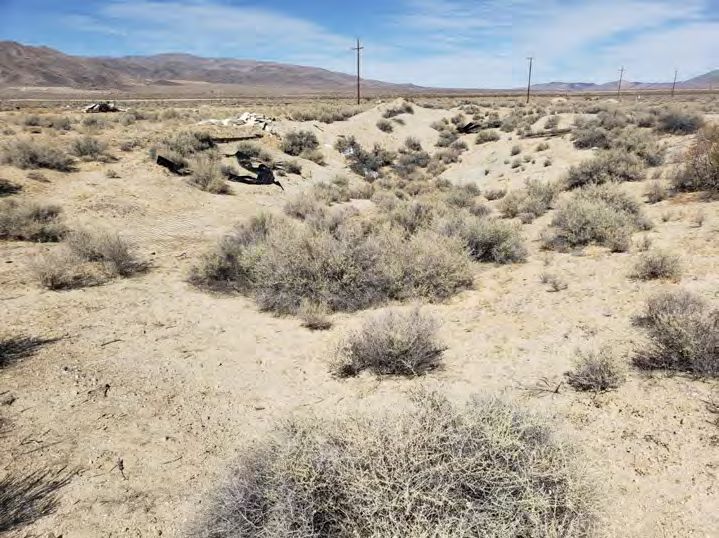
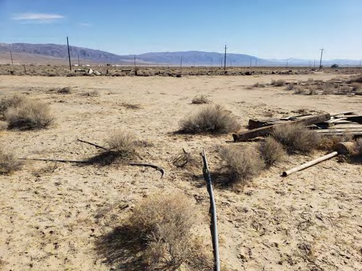
31 |EXHIBIT 1.
VIEW FROM THE SOUTHWEST CORNER OF THE PARCEL, FACING NORTHEAST (SEE
FIGURE 5 FOR LOCATIONS AND DIRECTIONS OF PHOTOGRAPHS).
EXHIBIT 2.
VIEW FROM THE SOUTHEAST CORNER OF THE PARCEL, FACING NORTHWEST.
32 |EXHIBIT 3.
PARTIALLY VEGETATED PIT LOCATED NEAR THE EAST-CENTER BOUNDARY,
FACING NORTH.
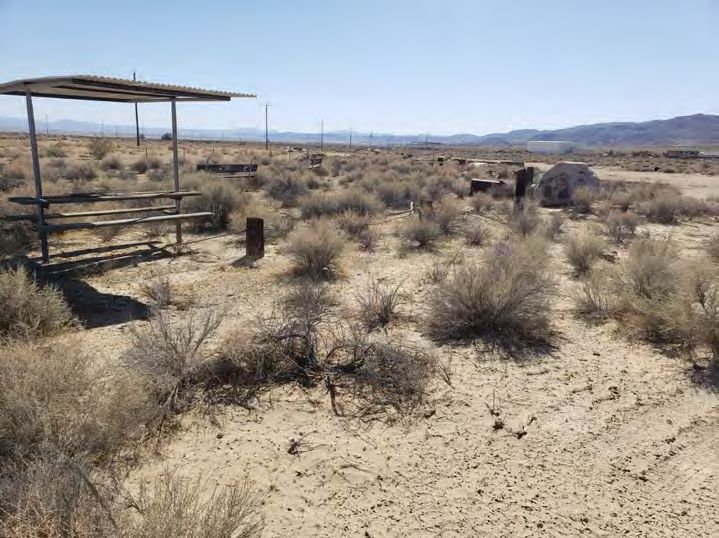
EXHIBIT 4.
ONE OF A HALF DOZEN PICNIC SHELTERS LOCATED NEAR THE CENTER OF THE
SITE, FACING NORTH.
33 |EXHIBIT 5.
ANOTHER OF THE PICNIC SHELTERS, NEAR THE NORTH BOUNDARY, FACING
SOUTH.
EXHIBIT 6.
VIEW FROM THE NORTHEAST CORNER OF THE PARCEL, FACING SOUTHWEST.
34 |EXHIBIT 7.
VIEW FROM THE NORTHWEST CORNER OF THE PARCEL, FACING SOUTHEAST.
35 |M O B I LE 62 6 .6 2 6 .6 1 86 O F F I CE 76 0 . 42 8 . 80 6 8 I N F O @ G E Ō D E ENVIRONMENTAL.COM W W W . GEŌDEENVIRONMENTAL.COM
You can also read