Land Use and Plant Diversity of the Dahliafleur Reserve of Bingerville (South of Côte d'Ivoire)
←
→
Page content transcription
If your browser does not render page correctly, please read the page content below
Land Use and Plant Diversity of the
Dahliafleur Reserve of Bingerville
(South of Côte d’Ivoire)
Konan Akissi Elise1, Koffi Kouadio Arsène Dieudonné1,
Kouassi Konan Edouard1,2, Silue Pagadjovongo Adama3,
Kouakou Abell Mike1, Koutouan Mylène1,2,
Kone Kouhounatchoho Arthur1
1
Université Félix Houphouët-Boigny d’Abidjan, Laboratoire « Milieux des Milieux Naturels et Conservation de la Biodiversité », UFR
Biosciences
2
Université Félix Houphouët-Boigny d’Abidjan, Laboratoire « Milieux des Milieux Naturels et Conservation de la Biodiversité », UFR
Biosciences. West African Science Service Center on Climate Change and Adapted Land Use/Centre d'Excellence Africain sur le Changement
Climatique, la Biodiversité et l'Agriculture Durable (WASCAL/CEA-CCBAB)
3
Université Péléforo Gon Coulibaly de Korhogo, Département de Biologie Végétale, UFR Sciences Biologiques
Abstract: Bingerville is one of the cities of the District of Abidjan which are experiencing rampant urbanization. Despite this urbanization, the
government has managed to preserve an area called the Dahliafleur Reserve as a refuge for biodiversity in this highly urbanized area. The
sustainable management of this Reserve inevitably requires knowledge of the different types of land use and flora. The objective of the present
study was to determine the ecological role that this Reserve could play. Land cover mapping and botanical inventories were the main methods
used. The results obtained revealed a variability of the types of occupation and of the soil with different surface areas. The Reserve is made up of
mosaics of secondary forests, fallow land and bamboo groves. The characterization of the flora made it possible to identify 107 species divided
into 87 genera and 44 families. The Guinean-Congolese species are the most abundant. Phanerophytes are dominant in the Reserve. The presence
of a non-negligible number of species with special status marks an interest in conservation in this anthropized environment. The diversity indices
and specific richness are low. These relatively low values confirm the state of degradation of the vegetation already revealed by satellite images
in the Reserve.
Keywords: Dynamics, Biodiversity, Conservation, Dahliafleur, Côte d'Ivoire
Introduction biodiversity at the heart of sustainable development
The need to conserve and protect biological diversity policies. It follows the need for cities to publish
on a planetary scale was established in the framework policies to protect urban biodiversity or update
of the Rio Convention, adopted in 1992. Since then, policies for the protection of urban green spaces for
the principle of maintaining biodiversity has occupied this purpose.
a central place in the various conventions and various
principles of sustainable development. Biological Cities play a major part in providing services and
diversity is however still considered, at least in built facilities, in addressing inequalities and in
popular discourse, as an issue reserved for tropical managing environments that promote human health.
areas, or at least for natural environments far from For example, urbanization can increase exposure to
urban areas (Elander et al., 2005). The role of common risk factors for noncommunicable diseases,
biodiversity in maintaining facilities and the services such as changes in physical activity and diet.
it provides to humans have not yet been integrated Urbanization is also generally accompanied by an
into collective consciousness. This statement is increase in air pollution which causes significant
attested to be truer for humans living in urban areas. mortality from cardiovascular and respiratory
However, these environments constitute a complex diseases. However, urban forests contribute to the
and dynamic mosaic of biotopes (Pickett and quality of life of communities through the ecological
Cadenasso, 2006), offering multiple habitats for services they provide. And, finally, because urban
many species of animals and plants. At the biodiversity is often the only reservoir of nature with
International Conference on Biodiversity entitled which some residents come into contact (Müller and
Science and Governance held in Paris in 2005, a Werner, 2010). Many cities are already taking action
shared enlargement issue was the safeguard of natural in this direction, in an innovative, enthusiastic and
elements in urban and peri-urban environments. This inspiring way. This is the case of the District of
raised the question of the conservation of urban Abidjan which has the Banco National Park (PNB)
This article is published under the terms of the Creative Commons Attribution License 4.0
Author(s) retain the copyright of this article. Publication rights with Alkhaer Publications.
Published at: http://www.ijsciences.com/pub/issue/2021-06/
DOI: 10.18483/ijSci.2461; Online ISSN: 2305-3925; Print ISSN: 2410-4477
Article Submission Date: 2021-03-22 Acceptance Date: 2021-06-20 Publication Date: 2021-06-24
Koffi Kouadio Arsène Dieudonné (Correspondence)
+
Land Use and Plant Diversity of the Dahliafleur Reserve of Bingerville (South of Cote d’Ivoire)
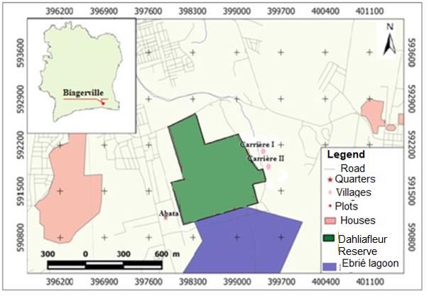
and the Dahliafleur Reserve in Bingerville. For the Reserve covers an area of 148 hectares. It is limited
latter, it is located in an area that is experiencing a in its northern part, by the villages “Carrière I and II”
real estate boom leading to the destruction of plant and by the Ebrié lagoon in its eastern part (Monssou,
cover in urban areas and its corollaries. The objective 2018). To the south and west, residential areas limit
of this study is to determine the ecological role of the it. The corresponding climate is of the subequatorial
Dahliafleur Reserve in a highly urbanized area. type (Edlin et al., 1971). It is characterized by high
Specifically, this will involve studying land use, rainfall and high humidity, daytime temperatures
analyzing the flora and evaluating the carbon average 25˚C to 30˚C annually and abundant rainfall
footprint of this Reserve. reaches 350 mm in the month of June (Asseh, 2019).
It has two seasons, a rainy and a dry one. The rainy
2. Methodology season spans two periods: March to July and
2.1. Study site September to November. The dry season is also
The Dahliafleur Reserve is located in the spread over two periods: from December to February
municipality of Bingerville in the District of Abidjan and the month of August.
in the south of the Côte d’Ivoire (Figure 1). The
Figure 1: Location of the study area (Monssou et al., 2018)
2.2. Data collection method preprocessing of satellite images; extracting
The data collection was structured around three information from images; and the field description of
methods. Remote sensing analysis techniques and the the types of occupations identified during the pre-
Geographic Information System (GIS) were first used treatment.
to map the vegetation cover for 2020. Botanical
2.2.2. Method of botanical inventories of different
inventories were carried out to characterize the flora
types of land use
in the different types of vegetation land use and
The botanical inventories were carried out using two
estimate the woody biomass of the Dahliafleur
complementary methods of floristic surveys: itinerant
Reserve.
surveys and surface surveys. The combination of
2.2.1. Mapping of current land use these methods made it possible to identify the
The production of the maps was made possible maximum number of species present in the types of
thanks to the various data collection missions in the land cover.
field. The mapping was carried out in three stages:
http://www.ijSciences.com Volume 10 – June 2021 (06)
30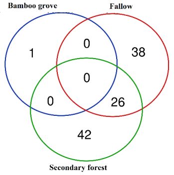
Land Use and Plant Diversity of the Dahliafleur Reserve of Bingerville (South of Cote d’Ivoire)

The surface survey method is commonly used for                             possible to calculate the probability of a pixel to
forest inventories (Adou Yao et al., 2007; Kouassi,                        belong to a certain class and therefore to reduce the
2000; Kouassi, 2007). It consists of listing all the taxa                  risks of error of misclassified pixels by making the
found on areas of varying shapes with the aim of                           best use of the membership probabilities (Oszwald,
identifying as many species as possible (Kouamé,                           2005).
2009). In our study, square plots of 25 m x 25 m (625
m2) were installed in the different types of land use.                     2.3.1.2. Validation of classifications
In each type of land use, six (06) plots were installed                    The validation of treatments makes it possible to
and arranged at random. Once the plots are delimited,                      assess the overall performance level of the treatment.
their geographic coordinates are recorded using the                        This, in order to restore as faithfully as possible the
GPS receiver. In these plots, the presence of all the                      land use classes described in the field. This leads to
species encountered was noted. The circumferences                          the development and analysis of the matrix of
of arborescent individuals with a diameter at human                        confusion.
breast height (DBH) greater than or equal to 5 cm
were also measured. Choosing a minimum DBH of 5                            It comprises two stages: the choice of control plots
cm maximizes the diversity of plant species.                               and the calculation of the cartographic precision.
According to Tchouto (2004), Kouamé et al. (2008)
and Kouamé (2009), the diversity reflected only by                         The control plots correspond to sites described during
individuals with DBH ≥ 10 cm, does not reflect more                        the field visit but which were not used during
than 50 p.c. of all the diversity of an environment.                       training. A correspondence was established between
Also, Vroh (2013) have shown that the diversity of                         the training plots and the control plots to assess the
tree species is maximized when DBH is reduced in                           accuracy of the classification between the land use
dense forest.                                                              classes. Once the supervised classification was
                                                                           validated, a median 3 x 3 filter was applied. This
The method of surface survey was also used. It                             filter reduced intra-class heterogeneity to eliminate
consisted in traversing the environment by picking up                      isolated pixels.
all the plant individuals encountered. This method is
suitable for quick inventories, sites that are difficult                   2.3.1.3. Spatial analysis of land use
                                                                           In this study, it will be a question of carrying out a
to penetrate or large surfaces (Vroh, 2013). All
                                                                           remote sensing analysis which will consist in
species not identified on site were collected to be
identified by comparison with herbarium samples                            determining the different types of land use for the
from the National Floristic Center of Félix                                date 2020 and subsequently evaluating the area of
                                                                           each land use.
Houphouët-Boigny University.
                                                                           2.3.2. Floristic data analyzes
2.3. Data analyzes
                                                                           2.3.2.1. Floristic richness
2.3.1. Cartographic data analyzes
Three major successive phases have made it possible                        Floristic richness is defined as the number of species
to produce the maps: the supervised or directed                            recorded in a given territory (Aké-Assi, 1984). Its
                                                                           measure consists in counting all the species recorded
classification of satellite images, their validation and
                                                                           in each habitat without taking into account their
the characterization of the dynamic of land use.
                                                                           abundance. It was the same for the families and
                                                                           genera of the listed species. The nomenclature of
2.3.1.1. Supervised classification of images
                                                                           plant species adopted is that of Hutchinson & Dalziel
Classification corresponds to the action of
                                                                           (1972), revised by Lebrun and Stork (1991-1997) and
extrapolating, over the entire satellite image, test
                                                                           updated by APG IV. The compilation of all these lists
areas previously chosen during field visits and whose
                                                                           provided the number of species in each habitat
thematic significance is known (Oszwald, 2005).
                                                                           (secondary forests, fallows, and bamboo groves).
Two major stages characterize this phase. This is on                       2.3.2.2. Floristic composition
the one hand the selection of training plots and on the                    The analysis of the floristic composition consisted in
other hand the application of the classification                           noting for each identified species, the biological type,
algorithm. The training plots were selected on the                         the phytogeographic affinity based on the work of
basis of the sites visited and described during the data                   Aké-Assi (2001; 2002) The biological type of a
collection campaigns. Thus, 18 plots representing all                      species is the whole anatomical and morphological
types of land use were used as training for this                           features which characterize its vegetative apparatus
treatment.                                                                 and which distinguish its physiognomy and habitat
                                                                           (Sørensen,        1948;       Hakizimana,        2012).
For this study, the most suitable algorithm for                            Phytogeographic affinities were used to distribute
vegetation is maximum likelihood (Brou, 2005;                              species according to their geographic distribution
Oszwald, 2005; Diallo et al., 2011). It makes it                           area. Thus, the following have been distinguished:

http://www.ijSciences.com                                                                 Volume 10 – June 2021 (06)
                                                                                                                                      31
Land Use and Plant Diversity of the Dahliafleur Reserve of Bingerville (South of Cote d’Ivoire)
the Guineo-Congolese species (GC). These species
are distributed in the Guinean-Congolese E = H’ / / lnS
phytogeographic region, the species (GC-SZ)
subservient to the Guinean-Congolese and Sudano- In this formula, E denotes the Pielou index, H ’is the
Zambezian transition phytogeographic regions. Shannon index and S represents the total number of
Species (SZ) whose distribution area is in the species in the plot or area concerned.
Sudano-Zambezian phytogeographic region and,
exotic or introduced species (I). 2.3.2.3.3. Margalef diversity index
The diversity index proposed by Margalef (1957) is
2.3.2.3. Diversity indices the quantity where n1, n2, ns are the numbers of
2.3.2.3.1. Shannon diversity index (H ’) species encountered in the sample, and N = n1 + n2 +
The Shannon Index (H ’) measures the species ns. It represents the average amount of information
composition of a stand, taking into account species (measured in bits) provided by the determination of
richness and relative abundance. an individual belonging to one of the S species. It is
zero in the case of a single species (n1 = N),
It has a value normally between 0 and 5 according to maximum and substantially equal to log2 S when the
Magurran (2004), when it is calculated with the S species are also represented. Its mathematical
Natural logarithm (ln). expression is as follows:
If we denote by N the total number of S species Rmg = S/ѴN
considered, nor the number of individuals of a
species i and ln (ni / N) the relative abundance of
species i. It is calculated using the following formula: With S number of species and N number of
individuals. It was calculated because it corrects error
H’ = -∑ [(ni/N) x ln (ni/N)] bias because our different sites are not the same size.
This index varies from 0 (only one species present) to 2.3.2.4. Venn diagram
ln (S) (all the species present have the same Venn diagram also called logic diagram, allows to
abundance, therefore good diversity). represent sets and their intersections. As part of our
study we used the Venn diagram to graphically
This index varies from 0 (only one species present) to represent the number of species common to land
ln (S) (all the species present have the same uses. The intercept between two circles is the number
abundance, therefore good diversity). of common species between two land uses (Venn,
1880).
2.3.2.3.2. Piélou index (1966)
For a stand, Pielou index tells us about the 3. Results
distribution of numbers among the different species. 3.1. Land uses in the Dahliafleur Reserve
The calculation of the specific diversity index is The 2020 land use map made it possible to have the
always accompanied by that of equity, because two areas of the different types of land use and much
stands with different physiognomy can have the same more to know the exact location of each type of land
diversity (Kouadio, 2006). Piélou's (1966) equity use on the site.
index (E), also called the equal distribution index
(Blondel, 1979) is the ratio of the sample's Shannon The land uses identified by the mapping are:
index to maximum diversity. Pielou index varies secondary forests, fallows and bamboo plantations
from 0 to 1. It tends towards 0 when almost all the (Figure 2). The overall precision and the Kappa
numbers are concentrated in one species and towards coefficient are respectively 90.44% and 89.64%.
1 when all species have the same abundance. If this There is some confusion between certain classes. The
index tends towards 1, the medium in question is said highest are found between the fallow class and the
to be balanced. This index allowed us to highlight the forest and bamboo grove classes. These confusions
level of balance of the different biotopes of the site. It are respectively 15.11 and 15.52 (Table 1).
is calculated using the following mathematical
formula:
http://www.ijSciences.com Volume 10 – June 2021 (06)
32Land Use and Plant Diversity of the Dahliafleur Reserve of Bingerville (South of Cote d’Ivoire)
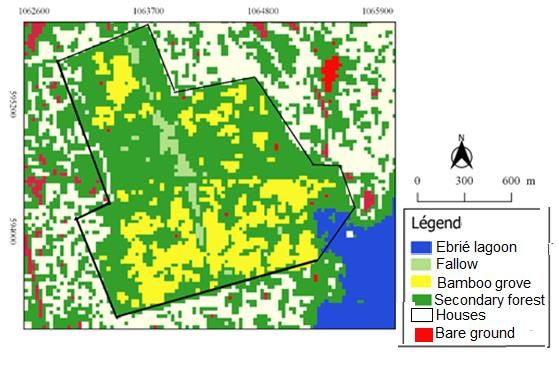
Figure 2: Maps of different land uses in Dahliafleur Reserve
Table 1: Confusion matrix of the 2020 mapping
Overall accuracy = 90.44%
Kappa coefficient = 89.64
Secondary
Classes Houses/Bare ground Bamboo grove Fallow Water
forest
Houses/Bare ground 97,08 0 0 1,94 6,69
Secondary forest 0 79,01 8,21 0,78 0,23
Bamboo grove 0 5,88 72,54 1,16 0
Fallow 2,92 15,11 15,52 96,12 0,35
Water 0 0 3,73 0 92,73
Total 100 100 100 100 100
3.1.1. Secondary forests
Secondary forests are regrowth of vegetation. In other 3.1.3 Bamboo groves
words, these are forests destroyed by human activities Bamboo groves constitute a monospecific plant
or not and which are recovering. The most common formation, made up of a stratum made up of bamboo
species are: Rauvolfia vomitoria Afzel, Sterculia stubble and whose undergrowth is practically empty
tragacantha Lindl, Scottellia klaineana Pierre var. given the very high cover. They cover an area of
klaineana. There is a woody vegetation with 3 strata. 44.65 ha and are found more on the west and south
These are the lower stratum (2 to 8 m in height), the side of the Reserve.
middle stratum (8 to 16 m in height) and the upper
stratum (16 m and more in height). Secondary forests Table 2: Area of the different land uses in Dahliafleur Reserve
cover practically the entire Reserve with an area of Land use
90.89 ha (Table 2). Area (ha)
Secondary forest 90.89
3.1.2. Fallows Fallow 19.13
Fallow land is an environment abandoned after Bamboo grove 44.65
cultivation. These are old plots of crops cultivated in Water 4.78
the area. They vary with age. Their configuration and
diversity can be assimilated to those of natural
formations depending on the stage of reconstitution.
They have an area of 19.13 ha, and are mostly located
in the center of the Reserve. There are species such as
Piptadeniastrum africanum, Strombosia pustulata,
Dracaena arborea.
http://www.ijSciences.com Volume 10 – June 2021 (06)
33Land Use and Plant Diversity of the Dahliafleur Reserve of Bingerville (South of Cote d’Ivoire)
3.2. Diversity of land uses in the study area
3.2.1. Specific richness
The flora of the Dahliafleur Reserve includes 107
species, divided into 87 genera and 44 families. The
Fabaceae family is the most diverse with 17 species,
ie a rate of 16%. It is followed by the Apocynaceae
with nine (09) species ie 8%, the Moraceae with
seven (07) species ie a rate of 7% and Euphorbiaceae
with the seven (07) species ie a rate of 6%. Certain
families like those of Anacardiaceae, Arecaceae,
Asclepiadaceae, Asteraceae, etc., are represented by a
single species. These monospecific families represent
50% of the flora.
Secondary forests include 68 species, 54 genera and
35 families (Table 3). That of fallows includes 64
species, 59 genera and 29 families. On the other
hand, in bamboo groves, there is only one (01) single
Figure 4: Histograms of the areas of the different land uses in the
species, one (01) single genus and one (01) single
Dahliafleur Reserve family. It is Bambusa vulgaris. The families most
represented in secondary forests and fallows are
Fabaceae, Apocynaceae, Moraceae and
Euphorbiaceae with different proportions (Figures 5
and 6).
Table 1: Floristic richness of Dahliafleur Reserve by land uses
Average specific
Land use Number of species Number of genera Number of families
richness
Secondary forest 68 54 35 17.50±5.47b
Fallow 64 59 29 17.17±5.67b
Bamboo grove 1 1 1 1.0±0.0a
Total Dahliafleur 107 87 44 χ²=11.85 ; p-valueLand Use and Plant Diversity of the Dahliafleur Reserve of Bingerville (South of Cote d’Ivoire)
Figure 7: Histogram of the distribution of biological types by land uses
3.2.2.2. Phytogeographical types and fallow land, presents the same order of
All the species inventoried on the study site belong to dominance of phytogeographical types. The GC
five (05) phytogeographic types. Within the various species are those which dominate the flora of the
land uses a tendency emerges. The Dahliafleur Dahliafleur Reserve and those of the various land
Reserve, through land uses such as secondary forests uses (figure 8).
Figure 8: Histogram of the distribution of phytogeographic types by land use
GC: Taxon of the Guineo-Congolese region; GCW: on the Aké-Assi list, these are Lannea nigritana and
Taxon endemic to the forest block in western Togo; Milicia excelsa (Table 4). Among the species
GCi: Taxon endemic to Côte d'Ivoire; SZ: Sudano- recorded in the Reserve, seven (07) are endemic to
Zambesian region taxon; GC-SZ: Taxon of the West Africa (GCW), one (01) is endemic to Côte
Guinea-Congolese and Sudano-Zambesian transition d'Ivoire (Gci). These are Leptoderris miegei (Table
zone; i: introduced. 4). Six (6) species are endemic to Upper Guinea.
These are Baissea zygodioides, Myrianthus libericus,
3.2.3. Conservation value of the biodiversity of the Landolphia membranacea, Placodiscus attenuatus,
Reserve Placodiscus pseudostipularis, Anthocleista nobilis. In
The comparison of the species listed with those of terms of land uses, secondary forests constitute the
Aké Assi (1998) and IUCN (2019), allowed us to most diverse land uses in species with special status,
identify three (03) species which appear on the IUCN they are followed by fallows. Bamboo grove, on the
red list which are Milicia regia (vulnerable), other hand, have no species of conservation value
Placodiscus attenuatus, Placodiscus pseudostipularis (Table 4).
both endangered (Table IV), two (2) species appear
http://www.ijSciences.com Volume 10 – June 2021 (06)
35Land Use and Plant Diversity of the Dahliafleur Reserve of Bingerville (South of Cote d’Ivoire)
Table 2 : List of species with special status recorded in the Dahliafleur Reserve
Aké-Assi
Species Land uses Endemism IUCN 2019
1998
1 Afzelia bella Secondary forest GCW
2 Anthocleista nobilis Fallow GCW-HG
3 Baissea zygodioides Fallow HG
4 Dracaena cristula Fallow - Secondary forest GCW
5 Landolphia membranacea Secondary forest GCW-HG
6 Lannea nigritana Fallow PRE
7 Leptoderris miegei Secondary forest Gci
8 Milicia excelsa Secondary forest PRE
9 Milicia regia Secondary forest GCW Vulnerable
10 Myrianthus libericus Fallow - Secondary forest HG
11 Placodiscus attenuatus Secondary forest GCW-HG Endangered
12 Placodiscus pseudostipularis Fallow - Secondary forest GCW-HG Endangered
Table 3 : Distribution of species with special status in the different land uses
Endemic species IUCN (2019) Aké Assi (1998)
Land uses
Gci GCW HG Endangered Vulnerable PRE
Bamboo grove 0 0 0 0 0 0
Secondary forest 1 6 6 2 1 2
Fallow 0 3 4 1 0 1
3.2.4. Floristic diversity indices
3.2.4.1. Intra-specific diversity indices The value of the Pielou index for fallow and
Considering the different types land uses, the value of secondary forest tends towards 1, which reflects an
the Shannon index varied from one land use to equipartition of individuals within the different land
another. The largest mean value of the Shannon index uses. The zero value in bamboo grove translates into
(2.45±0.24 bits) was observed in the fallow (Table 6). the dominance of a single species in this land use
The lowest value was recorded in the bamboo grove which is Bambusa vulgaris. The average values are
with an average index of 0.0 ± 0.0 bit. Its values not statistically different.
reflect a good diversity of species in fallow, unlike
the zero value in the bamboo grove which quite Margalef index values vary from 2.47±0.56 bits to
simply means the existence of a single species in this 0.12 ± 0.03 bits respectively for secondary forest and
land use. The average values are not statistically bamboo grove. These values show a good diversity of
different. species in secondary forest and fallow. The average
values are not statistically different.
The Pielou index values vary from 0.88 bit to 0.0
respectively for fallow and bamboo grove.
Table 6. Specific diversity in the different land uses
Shannon index Pielou index Margalef index
Secondary forest 2.43±0.45b 0.86±0.1a 2.47±0.56b
Fallow 2.45±0.24b 0.88±0.07b 2.36±0.4b
Bamboo grove 0.86±0.1a 0±0a 0.12±0.03a
Statistic χ²=11.9 ; p-valueLand Use and Plant Diversity of the Dahliafleur Reserve of Bingerville (South of Cote d’Ivoire)
Discussion or environmental heterogeneity.
The value of the Kappa coefficient is 89.64. The
classifications are therefore considered acceptable The Dahliafleur Reserve is dominated by botanical
because the values of the Kappa coefficient are families such as Fabaceae, Apocynaceae,
greater than 75 p.c (Girard and Girard, 1999). Euphorbiaceae, and Moraceae. Indeed, the majority
Because of this, there is a substantial agreement of ivorian forests are dominated by the same families
between the cards and the truth on the ground. The (Kouamé et al., 1998; Nusbaumer et al., 2005; N’Da
values of this coefficient are close to those found by et al., 2008).
Gnagbo (2015) who worked in Azagny with the same
types of images. Whereas N’Da (2007) and Sangne Phanerophytes are most abundant in secondary
(2009) obtained values of the Kappa coefficient forests and fallows. This dominance of
different from ours. This difference is due to the fact phanerophytes does not depart from the high
that these authors worked in areas belonging to the diversity of tree species often reported in tropical
mesophilic sector of the Guinean domain. Following forests (Blanc et al., 2003). Our results are confirmed
our study, it should be noted that certain confusions by Sokpon (1995) and Habiyaremye (1997) who also
encountered are to be noted. Coming in the same demonstrated the dominance of phanerophytes in
view, Pontius (2000) meant that the results of an their study areas. According to these authors, it is the
image analysis with a Kappa coefficient greater than rule that in the forest phanerophytes form almost the
50% are good and usable. Therefore, there is a entire floristic procession and that the other
relationship between the maps designed and the biological types are poorly represented. The low
ground truth. Several authors, as Kpangui (2010) who representativeness of hemicryptophytes, geophytes
conducted his study in Kokumbo; Sangne et al. and therophytes is not only the prerogative of the
(2015) in Haut-Sassandra, emphasized that the use of Dahliafleur Reserve. The low proportions of these
remote sensing indices provide useful and potential biological types, mostly heliophilic species, can be
information for the knowledge of the state of the explained by the dominance of phanerophytes which
vegetation cover of a territory. The spatial analysis of reduce their establishment (Bangirinama et al., 2010).
the land use using sentinel images, took place in two The same observation was also made in evergreen
phases including the determination of the areas of the forest by Devineau (1984).
land use units and the exact location of each of the
land uses the results of the cartographic analysis Guineo-Congolese species are largely dominant in
show that secondary forests have the largest area with secondary forests and fallows. According to Sonké
90.89 ha, then bamboo groves with 44.65 ha and (1998), the high proportion of these species in the
finally fallow with 19.13 ha. These values can be floral procession of a forest is proof that it does
explained by the fact that since the acquisition of the indeed belong to the Guineo-Congolese region of
site it has not been systematically destroyed as a White (1983). According to White (1983), the
whole. And its good conservation allows it to Guinean-Congolese flora is very pure with more than
reconstitute itself slowly and tend towards its original 80 to 90 p.c of endemic species and only about 10 p.c
status. This could explain the dominance of of species of binding elements. The relatively large
secondary forests at this site. The low proportion of proportions of species in the GC-SZ transition zone
fallows may be due to the fact that the aggressions are evidence that all site spaces still suffer from the
are not completely canceled. Thus, the new persistent effects of degradation (Assié et al., 2008).
destruction of vegetation explains the presence of
fallows. The non-negligible proportions of species with
special status give the Dahliafleur Reserve a
The area (44.65 ha) of bamboo groves can be particular interest for conservation as suggested by
explained by the fact that they are very competitive Myers et al. (2000). According to these authors,
species in tropical forests, so their intensive conservation efforts for endemic species, rare species
proliferation has extended to this spatial occupation and endangered species must be a priority in this kind
of this site. of space.
The present study revealed 107 species, divided into This richness in species with special status contrasts
87 genera and 44 families. Our results are with the urban environment and could be the result of
comparable to those obtained by Asseh (2019). This a more or less effective development and
author, during his work in the Dahliafleur Reserve, conservation policy entrusted to various State
identified 106 species divided between 39 genera. structures such as the OIPR for the Dahliafleur
The low diversity of the Reserve can also be Reserve (Monssou, 2018)
explained by the homogeneity of the vegetation.
Indeed, according to Mbaygone (2008), the greatest The low values of the diversity indices could be
floristic diversity is linked to the diversity of habitats explained by the lack of stability of the flora of the
http://www.ijSciences.com Volume 10 – June 2021 (06)
37Land Use and Plant Diversity of the Dahliafleur Reserve of Bingerville (South of Cote d’Ivoire)
different types of land use of the Reserve. Because l’Université Félix Houphouët-Boigny, Spécialité
Systématique, Ecologie et Biodiversité Végétale, 245 p.
according to Loubier (2001), the more unstable a
6. Assié K. H., Angui K. T. P. et Tamia A. J. (2008). Effets de
space, the less diversified it is. The Dahliafleur la mise en culture et des contraintes naturelles sur quelques
Reserve still continues to suffer from anthropogenic propriétés physiques d’un sol ferralitique au centre ouest de
pressures despite its status. la Côte d’Ivoire : conséquences sur la dégradation des sols.
European Journal of Scientific Research, 23 (1): 149-166.
7. Bangirinama F., Bigendako M. J, Lejoly J., Noret N., De
The low floristic similarity between the different Cannière C. & Bogaert J. (2010). Les indicateurs de la
types of land use in the Dahliafleur Reserve is due to dynamique post-culturale de la végétation des jachères dans
the fact that these areas do not present the same la partie savane de la réserve naturelle forestière de Kigwena
(Burundi). Plant Ecology and Evolution 143 : 138-147.
metological conditions. This suggests that the 8. Blanc L., Florès O., Molino J. F., Gourlet S.-Fleury et
Dahliafleur Reserve presents floristic variability, Sabatier D. (2003). Diversité spécifique et regroupement
diverse habitats and great variability in ecological d’espèces arborescentes en forêt guyanaise. Revue Forestière
conditions. Française. LV. 16 p.
9. Blondel J., 1979. Biologie et Ecologie. Masson & Cie, Paris
Conclusion (France), 173 p.
The objective of this study was to determine the 10. Brou Y. T. (2005). Climat, mutations socio-économiques et
paysages en Côte d'Ivoire. Mémoire de synth. Université des
ecological role of the Dahliafleur Reserve. It has Sciences et Technologies de Lille, France, 212 p.
shown that this Reserve presents a variability in land 11. Devineau J.-L. (1984). Structure et dynamique de quelques
use. forêts tropophiles de l'Ouest africain (Côte d'Ivoire).
Université Pierre et Marie Curie-Paris VI. (France), 294 p.
12. Diallo H., Barnba, I., Barima Y.S.S., Visser M., Ballo A.,
The analysis of the flora made it possible to identify Marna A., Vranken I., Maïga M., et Bogaert J. (2011). Effets
107 species divided into 87 genera and 44 families. combinés du climat et des pressions anthropiques sur la
The most numerous families are Fabaceae, dynamique évolutive de la végétation d'une zone protégée du
Mali (Réserve de Fina, Boucle du baoulé). Sécheresse, 22 (3)
Apocynaceae, Euphorbiaceae and Moraceae.
: 97-107.
Microphanerophytes are dominant. Species from the 13. Edlin E., Avenard J.M., Girard G., Sircoulon J., Touchebeuf
Guineo-Congolese region also dominate the Reserve. P., Guillaumet J.L., Adjanohoun E. & Perraud A. (1971). Le
The significant presence of species with special status milieu naturel de la Côte d’Ivoire. ORSTOM, Paris, France,
p 73-108.
confers a particular interest for the conservation of
14. Elander I., Lundgren Alm E., Malbert B. and Sandstrôm U.G.
the Reserve. Unfortunately, this Reserve is still under (2005). «Biodiversity in urban governance and planning:
enormous human pressure. Agricultural practices, Examples from Swedish cities». Planning TheO/y and
severe constraints due to urbanization and sometimes Practiee, vol. 6, no 3, p. 283-301.
15. Hakizimana P. (2012). Analyse de la composition, de la
the collection of medicinal plants by the riparian structure spatiale et des ressources végétales naturelles
population and their regular penetration into the prélevées dans la forêt dense de Kigwena et dans la forêt
Reserve make it a very vulnerable forest mosaic. claire de Rumonge au Burundi (Unpublished doctoral
dissertation). Université libre de Bruxelles, Faculté des
Conflict of interests Sciences – Ecole Interfacultaire des Bioingénieurs, Bruxelles,
The authors have not declared any conflict of 141p.
interests. 16. Girard M. C. & Girard C. M. (1999). Traitement des données
de télédétection. Dunod, Paris, France, 529 p.
Acknowledgements 17. Gnagbo A. (2015). Diversité et distribution des épiphytes
vasculaires dans les forêts côtières de Côte d’Ivoire : Cas du
The authors express profound gratitude to Ivorian Parc National d’Azagny. Thèse Doctorat, UFR Biosciences,
Office of Parks and Reserves (OIPR) for for the easy Université Félix Houphouët-Boigny, Abidjan, Côte d’Ivoire,
access to the Reserve. 208 p.
18. Habiyaremye M. K. F. X. (1997). Étude phytosociologique
de la dorsale orientale du lac Kivu. Musée Royal de l’Afrique
References Centrale, Tervuren, Belgique; Annales Sciences
1. Adou Yao C.Y. (2007). Inventaire préliminaire de la flore et
Economiques, 24, 276 p.
description de la végétation de la Forêt des Marais Tanoé. 19. Hutchinson, J. & Dalziel, J.M., 1954-1972. Flora of West
Rapport pour RASAP-CI, Abidjan, Côte d'Ivoire.: 29 p. Tropica Africa, 2 nd edition. Revised by Key R.W.J., Hepper,
2. Aké-Assi L. (1984). La flore de la Côte d'Ivoire : étude
F.N. Crown Agent, London, 3 vol.
descriptive et biogéographique, avec quelques notes 20. Kouadio H.B. (2006). Apport de la télédétection et d’un
ethnobotaniques. Tome I, II, III. Thèse Doctorat d’État ès Sc. Système d’Information Géographique (SIG) a la gestion
Nat. FA.S.T., Université Nationale de Côte d’Ivoire, Abidjan,
intégrée et participative des aires protégées en Côte d’Ivoire :
1205 p. application au parc national de Comoé (réserve de
3. Aké-Assi L. (2001). Flore de la Côte d'Ivoire 1, catalogue, biosphère), Rapport d’étude, 66 p.
systématique, biogéographie et écologie. Conservatoire et
21. Kouamé N’. F. (1998). Influence de l’exploitation forestière
Jard. Bot., Genève, Switzerland, Boissiera 57, 396 p. sur la végétation et la flore de la forêt classée du Haut
4. Aké-Assi L. (2002). Flore de la Côte d'Ivoire 2, catalogue, Sassandra (Centre-Ouest de la Côte d’Ivoire). Thèse Doctorat
systématique, biogéographie et écologie. Conservatoire et
3ême Cycle, UFR Biosciences, Université Cocody-Abidjan.
Jard. Bot., Genève, Switzerland, Boissiera 58, 401 p. 227 pp.
5. Asseh E.E. (2019). Etudes floristique, phytogéographique et 22. Kouamé D., Adou Yao C. Y., Kouassi K. E., N'Guessan K.
ethnobotanique des Acanthaceae de Côte d’Ivoire : cas de la
E. & Akoi K. (2008). Preliminary floristic inventory and
Réserve Naturelle Partielle de Dahliafleur, dans le district diversity in Azagny National Park (Côte d'Ivoire). European
autonome d’Abidjan et essais de domestication de Justicia Journal of Scientific Research, 23 : 537 - 547.
flava (FORSSK) vahl, pour l’horticulture. Thèse de
23. Kouamé D. (2009). Rôle des animaux frugivores dans la
http://www.ijSciences.com Volume 10 – June 2021 (06)
38Land Use and Plant Diversity of the Dahliafleur Reserve of Bingerville (South of Cote d’Ivoire)
régénération et la conservation des forêts : cas de l'éléphant 38. Nusbaumer L., Gautier L., Châtelain C. & Spichiger R.
(Loxodonta africana cyclotis) dans le Parc National d'Azagny (2005). Structure et composition floristique de la forêt classée
(Sud-Ouest de la Côte d'Ivoire). Thèse de Doctorat, de Scio. Candollea, 60 (2) : 393-443.
Université de Cocody-Abidjan, Côte d’Ivoire, 208 p. 39. Oszwald J. (2005). Dynamique des formations
24. Kouassi, K. E., 2000. Contribution à l'étude de la Flore de la agroforestières en Côte d'Ivoire (des années 1980 aux années
Forêt Classée de la Haute Dodo, dans le Sud-Ouest de la Côte 2000). Université des Sciences et Technologies de Lille. UFR
d'Ivoire, par une approche de relevé de surface. Mém. D.E.A. de Géographie et d'aménagement, Laboratoire de Géographie
U.F.R. Biosciences, Université de Cocody, Abidjan, 102 p. des Milieux Anthropisés (UMR CNRS 8141). Thèse de
25. Kouassi, K. E. 2007 Flore de la Forêt Classée de la Haute Doctorat de Géographie, France, 304 p.
Dodo, dans le Sud-Ouest de la Côte d’Ivoire. Etude de 40. Pickett S.T.A, Cadenasso M.L. (2006). «Advancing urban
quelques espèces commercialisées : cas de Garcinia afzelii ecological studies: Frameworks, concepts, and results from
(Clusiaceae), des rotins (palmiers lianes) des genres Ihe Ballimore Ecosystem Study». Auslra/ Ecology, vol. 31, p.
Calamus, Eremospatha, et Laccosperma (Arecaceae). Mém. J 14-125.
Thèse unique. UFR Biosciences, Université de Cocody, 41. Piélou E. C. (1966). The measurement of diversity in
Abidjan, 214 p. different types of biological collections. Journal of
26. Kpangui K.B. (2010). Apport des Systèmes d’Informations Theoretical Biology, 13: 131-144.
Géographiques à l’étude de la diversité spécifique de 42. Pontius J.R. R. G., (2000). Quantification error versus
l’arboretum du Centre National de Floristique (Côte location error in comparison of categorical maps.
d’Ivoire). Mémoire DEA, Université de Cocody -Abidjan, Photogrammetric Engineering & Remote Sensing, 66: pp.
Côte d’Ivoire, 64 p. 1011-1016.
27. Lebrun, J.-P., & Stork, A. L., 1991. Énumération des plantes 43. Sangne Y. C. (2009). Dynamique du couvert forestier d’une
à fleurs d'Afrique tropicale : Généralités et Annonaceae à aire protégée soumise aux pressions anthropiques : cas de la
PandaceaeVol 1, Conservatoire et Jard. Bot., Genève, 249 p. forêt classée de Téné dans le département d’Oumé (Centre-
28. Lebrun, J.-P. & Stork, A. L., 1997. Énumération des plantes à Ouest de la Côte d’Ivoire). Thèse de Doctorat, Université de
fleurs d'Afrique tropicale: Gamopétales : Ericaceae à Cocody-Abidjan, Côte d’Ivoire, 220 p.
Lamiaceae, Vol 4, Conservatoire et Jard. Bot., Genève, 712 44. Sangne, C. Y., Barima, Y. S. S., Bamba, I., et N’Doumé, C.
p. T. A. (2015). Dynamique forestière post-conflits armés de la
29. Loubier J-C. (2001). Ecologie et SIG : un outil de gestion Forêt classée du Haut-Sassandra (Côte d’Ivoire), VertigO,
patrimoniale appliqué aux espaces naturels touristiques. 15(3): 1-18.
Vème rencontre de Théo Quant, 14 p. 45. Sonké B. (1998). Études floristiques et structurales des forêts
30. Magurran A.E. (2004). Measursuring biological diversity. de la réserve de faune du Dja (Cameroun). Thèse de
Blackwelll Publ. Company United Kingdom, New Jersey, Doctorat, Université Libre Bruxelles, Belgique, 267 p.
US, 248 p. 46. Sørensen T. (1948). A method of establishing groups of equal
31. Magarlef R. (1957). La teoria de la informacion en ecologia. amplitude in plant sociology based on similarity of species
Mem. Real Acad. Ciencias by Artes de Barcelona 32:373- content, and its application to analysis of the vegetation on
449. Danish commons. In GOUNOT, P. M. [ed.], Méthode d'étude
32. Mbayngone E. (2008). Flore et végétation de la réserve quantitative de la végétation. Masson et Cie, Paris, pp. 1-34.
partielle de la faune de Pama Sud-est du Burkina-Faso. Thèse 47. Sokpon N. (1995). Recherches écologiques sur la forêt dense
Unique, Univ. Ouagadougou (Burkina Faso). 138p + semi-décidue de Pobe au Sud-Est du Bénin : groupements
Annexes. végétaux, structure, régénération naturelle et chute de la
33. Monssou O.E. (2018). Diversité végétale et place du jardin litière. Thèse de doctorat, Université Libre de Bruxelles,
botanique de Bingerville et de la Réserve Naturelle Partielle Belgique, 350 p.
de Dahliafleur dans la vie des populations du district 48. Tchouto G. P. M. (2004). Plant diversity in Central African
d’Abidjan (Côte d’Ivoire). Thèse de l’Université Félix rain forest: implication for biodiversity conservation in
Houphouët-Boigny, Spécialité Systématique, Ecologie et Cameroon. PhD. Thesis, Departement of Plant Sciences,
Biodiversité Végétales, 191p. Biosystematic Group, Wageningen University, Pays-Bas, 208
34. Müller N. et Werner, P. (2010). « Urban biodiversity and the p.
case for implementing theconvention on biological diversity 49. Venn J. (1880). On the diagrammatic and mechanical
in towns and cities », in Müller, N., P. Werner and J. G. representation of propositions and reasonings. The London,
Kelcey (Ed.), Urban Biodiversity and Design, John Wiley Edinburg, and Dublin philosophical magazine and journal of
and Sons : Oxford, UK, chapter 1. science, 10(59): 1-18vieira D.L.M. Scenariot A., 2006.-
35. Myers N., Mittermeier R. A., Mittermeier C. G., Da Fonseca principle of natural regeneration of tropical dry forests
G. A. B. & Kent J. (2000). Biodiversity hotspots for restoration. Restoration Ecology 14 : 11-20.
conservation priorities. Nature, 403 : 853-858. 50. Vroh B. T. A. (2013). Evaluation de la dynamique de la
36. N’Da D. H. (2007). Étude et suivi par télédétection et végétation dans les zones agricoles d’Azaguié (sud-est, Côte
système d’information géographique d’une aire protégée d'Ivoire). Thèse Doctorat, UFR Biosciences, Université
soumise aux pressions. Thèse de Doctorat unique. Univ. Cocody- Abidjan, Côte d’Ivoire, 208 p.
Cocody-Abidjan, Côte d’Ivoire, 174 p. 51. White F. (1983). The Vegetation of Africa. A descriptive
37. N’Da D. H., Adou Y. C.Y., N’Guessan K. E., Koné M. & memoir to accompany the Unesco/AETFAT/UNSO map of
Sangne Y. C. (2008). Analyse de la diversité floristique du Africa, Unesco, Paris, France, 384 p.
parc national de la Marahoué, Centre-Ouest de la Côte
d’Ivoire. Afrique Science 04 (3) : 552 – 579.
http://www.ijSciences.com Volume 10 – June 2021 (06)
39You can also read