Draft Yarra Strategic Plan
Planning Evidence Statement for St.Kevins College
18 May 2020
←
→
Page content transcription
If your browser does not render page correctly, please read the page content below

Draft Yarra Strategic Plan Planning Evidence Statement for St.Kevins College 18 May 2020

Prepared for:         Prepared by:
St. Kevin’s College   Sophie Jordan Consulting Pty Ltd

                      PO Box 7200, Richmond

                      Victoria, 3121

                      T: 0414 857 650

                      E: sophie@sophiejordanconsulting.com.au

                      W: sophiejordanconsulting.com.au

                                                                2
Contents Page
                                                   Page

01 Introduction                                    5

02 St. Kevin’s College Land                        7

03 The Draft Yarra Strategic Plan                  11

04 The Current Planning Policy Framework           14

05 Analysis of the Strategic Plan                  23

06 Conclusions                                     31

Appendices
Appendix A    Summary of Professional Experience

                                                          3
4
1.0            Introduction

1. I have been requested by Norton Rose Fulbright on behalf of St Kevin’s College
   Toorak to prepare and present expert planning evidence with regard to the draft
   10 year Yarra Strategic Plan (the Strategic Plan) and the implications of this
   Strategic Plan from a statutory planning perspective on the land owned by
   St.Kevin’s College.

2. The Strategic Plan was released for public comment on 23 January 2020 and
   gives effect to the long term community vision for the Yarra River in the form of
   an integrated river corridor plan to manage the Yarra River and surrounding
   parklands for future generations across several public agencies.

3. I have not been involved in the preparation of any part of the Strategic Plan or
   any associated strategic documentation that has informed the current version of
   the Strategic Plan.

4. Since July 2019 I have been engaged by St Kevin’s College to provide statutory
   planning services. During this time I have prepared two planning permit
   applications for two of the school’s campuses being the Glendalough (Junior)
   Campus at 75 Lansell Road, Toorak and the Heyington (Senior) Campus at 31
   Moonga Road, Toorak respectively.

5. This statement of evidence has been informed by my experience as the planning
   consultant advising St Kevin’s College and my detailed understanding of the
   implications of the current planning framework on two of the school’s campuses
   in Toorak.

6. In preparing this statement I have undertaken the following:
   •   Reviewed the Strategic Plan including background reports;
   •   Reviewed the Lower Yarra River Corridor Study (November 2016);
   •   Reviewed relevant planning controls and policies relating to the Yarra River
       and private land adjacent to the River contained within the Stonnington,
       Boroondara and Yarra Planning Schemes, including Plan Melbourne 2017-
       2050;
   •   Reviewed Draft Yarra Strategic Plan Fact Sheet – Land Use Framework and
       Panel Process (January 2020);
   •   Reviewed Draft Yarra Strategic Plan – City of Stonnington Feedback (March
       2020); and
   •   Reviewed St Kevin’s College’s submission to Melbourne Water, prepared by
       Norton Rose Fulbright.
7. The following statement provides a summary of my assessment and opinions in
   relation to the Strategic Plan and outlines recommendations regarding further the
   final drafting of future planning controls.

8. For the purposes of this statement of evidence, included in Appendix A, is a
   summary of my experience and other relevant particulars.

                                                                                   6
2.0             St.Kevin’s College Land
2.1       St Kevin’s College Campuses

9. St Kevin’s College, Toorak comprises two major education campuses within the
   municipality of Stonnington. Both campuses are sited adjacent to the Yarra River
   and are proximate to Gardiner’s Creek (refer to Figure 1). These campuses are
   commonly referred to as the ‘Heyington Campus’, which is located at 31 Moonga
   Road, Toorak and at the ‘Glendalough Campus’ which is located at 73 – 75
   Lansell Road, Toorak.

                                               Glendalough Campus

                                                                    Heyington Campus

Figure 1: Aerial View of St Kevin’s Colleges
Source: Nearmaps 2020

10. St Kevin’s College has provided education for boys from years prep to year 12
    across both campuses for the last 50 years. The sites have gradually developed
    so as to provide new educational facilities and sporting facilities to keep abreast
    of modern standards. Importantly, each stage of development that the College
    has undertaken over the last few decades has occurred through close working
    relationship with key stakeholders i.e. City of Stonnington and the local
    community – to ensure the campuses continue to positively contribute to whilst
    minimise adverse impacts to the surrounding environment

11. The future of the Glendalough Campus and the Heyington Campus remains
    focused on educating junior, middle and senior students of St Kevin’s College. In
    order to ensure that a dynamic, supportive and progressive environment continue

                                                                                          7
to be afforded, that allows the students to grow and develop, St Kevin’s College
   will continue to improve their facilities not only from an operational but also the
   contemporary learning and recreational spaces.

12. The following section of this report provides an outline of the physical
    characteristics of each campus.

Glendalough Campus

13. The Glendalough Campus is the junior school of the St Kevin’s College and was
    established in 1972 following the issuing of planning permit ref: 70/261 by the
    City of Prahran. In 1999, the Glendalough Campus became a full primary school,
    catering for prep to year 6.

14. This campus is located on the northern side of Lansell Road and is bound by the
    Yarra River along the northern boundary of the site.

15. This campus has evolved over time, with each building program focused on
    providing its pupils with modern, purpose built facilities that address the needs of
    the student body at the time.

16. The school was originally built in the early 1970s, with additions constructed in
    the mid 1980s and more recently, the Boyd Egan Hall and the Victor McMahon
    Music Centre in 2014. Existing play areas and open space are apportioned to
    the north of the campus. Vegetation is largely concentrated along the northern
    and eastern site boundaries with screen planting and canopy trees.

       Key
       A – General teaching spaces
       B – Administration
       C – Music Centre
       D – Boyd Edgan Hall

                                                                                         8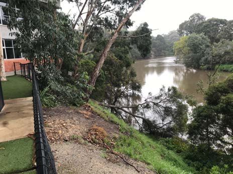
Heyington Campus

17. The Heyington Campus has been in operation since the 1960s. It exists within a
    small precinct that is not highly visible from any access street but is
    predominantly characterised by educational/ institutional facilities and is
    surrounded by generous areas of open space extending along the Yarra River.

18. The Heyington Campus features a total of seven buildings together with a small
    pavilion building which sits between the two ovals. The existing buildings are
    generally focused on the northern portion of the allotment and have been
    constructed over the last few decades in discrete stages. The last major
    expansion occurred in 2010 (planning permit ref: 1099/07) for a four storey
    building – commonly referred to as the ‘Godfrey Building’ (see building E on plan
    below).

2.1    Current Planning Applications

Glendalough Campus – 73 – 75 Lansell Road, Toorak

19. A planning application was lodged with the City of Stonnington on 12 November
    2019. This application seeks approval for buildings and works to the existing
    education centre (primary school) in a General Residential Zone. It includes the
    development of a new building at the southern boundary of the site, the
    construction of a car park for the sole use of the school and removal of vegetation

                                                                                        9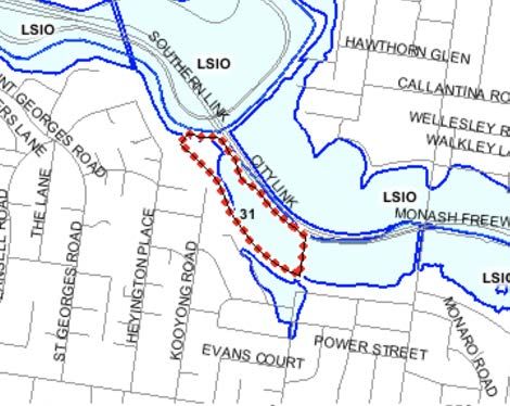
from the central playground area.

20. Further information was submitted to Council on 9 April 2020 and the application
    is due to proceed to public notification at the time of preparing this statement.
Heyington Campus – 31 Moonga Road, Toorak

21. Over the course of the last 9 months I have been involved in the preparation of a
    permit application relating to a proposed extension to the existing Wilding Centre
    (swimming pool building) located in the centre of the Heyington Campus.

22. The design for the proposed buildings and works is well progressed and a
    number of key specialists have been engaged to provide input, including
    consultation with Melbourne Water.

23. It is anticipated that this application will be submitted to the City of Stonnington
    before the end of the financial year.

                                                                                           10
03 The Draft Yarra Strategic Plan
24. The draft Yarra Strategic Plan (the Strategic Plan) was released for public
consultation on 23 January 2020, with community comment required by 29 March
2020.
25. The Strategic Plan was prepared by Melbourne Water as the lead agency in 2019
and seeks to respond to the increasing density and scale of recent developments
proposed and approved adjacent to the Yarra River and its environs. It has been
prepared using a collaborative governance approach by the Yarra Collaboration
Committee. The Committee, comprising a number of State and local government
departments, government agencies and the Wurundjeri Woi wurrung Cultural
Heritage Aboriginal Corporation, sought to identify a 50 year Community vision.
26. Fundamentally, the Strategic Plan recognises the importance of the Yarra River
and outlines the approach for the future management of the River corridor as it
extends through urban, suburban and semi rural environments. It provides a high
level regional strategic framework to guide future urban development for the
waterway and its surrounds to address challenges primarily presented by climate
change and population growth.
27. The Strategic Plan states that its various aims will be achieved through a revised
planning framework that will introduce new controls affecting land adjacent to the
Yarra River.
28. The Strategic Plan comprises two parts:
• Part 1: Working Together to Deliver the Community Vision, as required under
Section 17 of the Yarra River Protection Act 2017; and
• Part 2: Land Use Framework, as required under Section 20 (1)(b) of the Yarra
River Protection Act 2017.
Part 1 – Working Together to Delivery the Community Vision
29. Part 1 of the Strategic Plan amongst other things, includes four performance
objectives for the next 10 years. These are identified as follows:
• Objective 1: A healthy river and lands (improving the water quality of the
Yarra River and protecting its land, floodplains and billabongs to achieve
greater biodiversity)
• Objective 2: A culturally diverse river corridor (acknowledging, protecting and
commemorating the rich heritage of the Birrarung and its stories)
11• Objective 3: Quality parklands for a growing population (improving the river’s
parklands to support community wellbeing and strengthen the relationship
between the Yarra River, its community and visitors
• Objective 4: Protecting the natural beauty of the Yarra River corridor
(respecting the significance of the Yarra River’s landscapes. Where we build,
we will protect and celebrate the river’s natural beauty, landscapes and views
Part 2 – Land Use Framework
30. Part 2 of the Strategic Plan outlines the land use framework, intended to ensure
activities are aligned with the performance objectives described under Part 1 of
the Strategic Plan.
31. The land use framework acknowledges the unique characteristics of the Yarra
River, through the identification of the four ‘reaches’ or precincts from the central
city area of Melbourne and extending out to the Yarra Valle.
32. Both campuses of St Kevin’s College referred to in section 2.0 of this statement
are sited within the ‘Inner City Reach’, specifically, the Gardiners Creek
Confluence as illustrated in Figure 2 of the Strategic Plan.
33. The Strategic Plan puts forward that the Gardiners Creek has been substantially
impacted by surrounding infrastructure and this section of the creek has been
concreted. It further states that ‘while this impact will be long lasting, it is possible
that elements of the waterway’s environmental and cultural heritage could be
reintroduced as a means of reinterpreting this important confluence.’
34. Broadly, the directions for future land use and development within urban areas of
the ‘Inner City’ reach include:
• Improve the cover of native vegetation along the Yarra River through
parklands, private gardens and the local street network to enhance the
community’s sense of connection to the riverside environment.
• Select appropriate plant species to help restore ecological values, improve
biodiversity and contribute to urban cooling and greening.
• Apply integrated water management principles to all development to
maximise stormwater capture and reuse, and to limit runoff into waterways;
• Expand the recreational trail network and provide additional open space to
support community connection to the Yarra River.
• Ensure development is set back from the Yarra River’s edge to strengthen
the vegetation buffer along the waterway and ensure tree canopies retain
their dominance within the landscape. Development must also be set back
12from adjoining parklands and conservation areas to maintain views.
• Protect heritage buildings as important features of the Yarra River
landscape.
• Development in flood affected areas should refer to the Guidelines for
Development in Flood Affected Areas.
Figure 2: Gardiners Creek Confluence
Source: Draft Yarra Strategic Plan (page 120)
35. Specific to the Gardiners Creek Confluence, the opportunities for future projects
and alignment are identified as follows:
• Investigate options for improved environmental outcomes around the
Gardiners Creek confluence. This includes implementing initiatives
outlined in:
- Stonnington City Council’s Gardiners Creek Masterplan 2019
which includes a revegetation strategy for the creek.
- Boroondara City Council’s Urban Biodiversity Strategy 2013-2023
which nominates this area as a potential biodiversity hotspot.
13• Work with the Traditional Owners to provide interpretive information or
artwork about the cultural heritage of these waterways, both
contemporary and pre-European settlement.
• Maintain and strengthen indigenous planting along the Yarra Boulevard
and around the edge of Kevin Bartlett Reserve to improve habitat links.
- Ensure planning controls provide adequate setbacks and height
controls to protect the Yarra River’s landscape setting.
36. Following the finalisation of the Strategic Plan, Clause 12.03-1R- Yarra River
Protection of the Planning Policy Framework will be ‘updated’. The Strategic Plan
will be referenced or incorporated in the relevant planning schemes that include
land adjacent to the River. Timing for this or the extent to which Clause 12.03-1R
will be amended is unknown.
37. The Strategic Plan as exhibited also does not provide detail regarding the future
land use and built form controls to be implemented or any amendments to the
interim Design and Development Overlay or Significant Landscape Overlay that
has previously been introduced as part of the Amendment GC48.
1404 The Current Planning Policy
Framework
38. The following section summaries the relevant provisions of the Stonnington
Planning Scheme, which I have taken into account in the preparation of this
evidence statement, and which provides guidance on both the macro and micro
planning issues, and the long term vision for growth and development of the
St.Kevin’s College campuses which are located adjacent to the Yarra River and
its environs.
4.1 Planning Policy Framework
39. The Planning Policy Framework (PPF) seeks to develop the objectives for
planning in Victoria (as set out in the Planning and Environment Act 1987) to
foster appropriate land use and development planning policies and practices that
encompass relevant environmental, social and economic factors.
40. Of relevance to St Kevin’s College, within the existing built environment of Toorak
are the policies relating to the operation of the Planning Policy Framework
(Clause 10), Settlement (Clause 11), Environmental and Landscape Values
(Clause 12), the Built Environment and Heritage (Clause 15), Transport (Clause
18) and Infrastructure (Clause 19).
41. The key policy objectives that are derived from these relevant sections of the
PPF and which relate to the campuses include the following:
• Clause 11 (Settlement) – This Clause is focused on recognising the
needs of Victorians and identifying how planning should appropriately
respond to these needs through the provision of zoned and serviced land
that provides for a range of land use activities in order to create a healthy
and sustainable community.
• Clause 12.03-1S (River corridors, waterways, lakes and wetlands). This
Clause is focused on protecting and enhancing the environmental, cultural
and landscape values of all water bodies and wetlands including the Yarra
River.
• Clause 12.03-1R (Yarra River protection) to maintain and enhance the
natural landscape character of the Yarra River corridor. The strategies
designed to meet these objectives are:
- Strengthen the Yarra River’s natural environment, heritage and
overall height;
- Promote a sense of place and landscape;
- Retain and enhance people’s enjoyment of the river and its
15environment; and
- Ensure that development is designed and sited to maintain and
enhance the river’s secluded and natural environment.
• Clause 15 (Built Environment and Heritage) – This Clause seeks to
ensure that all new land use and development appropriately responds to
its landscape, valued built form and cultural context, and protect places
and sites with significant heritage, architectural, aesthetic, scientific and
cultural value. Clause 15.01-4 promotes the creation of health and
activity neighbourhoods, Clause 15.01- 5S refers to neighbourhood
character and Clause 15.03 provides specific policy guidance relating to
the conservation of places of heritage significance.
• Clause 19 (Infrastructure) – The broad range of this Clause covers the
development of social and physical infrastructure in a way that is efficient,
equitable, accessible and timely. The scope of this clause recognises
social needs of the community and promotes a range of accessible
community resources, such as education, cultural, health and community
support (mental health, aged care, disability, youth and family services)
facilities to meet growing communities.
• Clause 19.02-2S (Education Facilities) of the PPF specifically addresses
education centres within the overarching objective to “assist the
integration of education and early childhood facilities with local and
regional facilities”. The desire to see primary schools well connected with
the local residential community and public transport networks supports the
proposition that the integration of these types of land uses are important
to the creation of well rounded neighbourhoods including existing and
demand requirements. In addition, it is an objective to locate secondary
school education facilities in designated education precincts, highly
accessible to public transport.
42. Plan Melbourne (2017-2050) provides a broad strategic planning vision for
Victoria including the ongoing protection of the Yarra River. Outcome 4 and
Outcome 5 of Plan Melbourne are focused on building liveable communities and
has a series of policy directions that promote diverse and interconnected
neighbourhoods where a range of services and facilities including education
facilities are highly accessible, encouraging sustainable and healthy
communities.
43. In addition, Policy 4.14 of Plan Melbourne outlines the importance of protecting
and enhancing the metropolitan water’s edge parklands, noting the Yarra River
and its parklands have shaped the development of Melbourne and in turn, are
essential to the identity, liveability and prosperity of the city. Furthermore, there
is an emphasis on stronger planning controls to protect water’s edge parklands
from intrusion and encroachment of development that may impact upon open
16space and diminish their natural landscape setting.
4.2 Local Planning Policy Framework
44. The Local Planning Policy Framework (LPPF) of the Stonnington Planning
Scheme includes both the Municipal Strategic Statement (MSS) and local
policies. The following clauses of the MSS are considered to be the most
relevant to this Strategic Plan:
The MSS focuses on five strategic themes which seek to guide development
across the municipality. These themes include:
• Economic Development
• Housing
• Built Environment and Heritage
• Environment and Open Space
• Infrastructure
45. These themes seek to reinforce existing strengths of the municipality, identify
new opportunities for development and business opportunities, and minimise any
negative impacts of future use and development, including on the Yarra River.
46. Clause 21.07 is focused on Open Space and Environment. This Clause includes
the need to manage the impact of private development in and beside public open
space and protection of the environmental and landscape values of vulnerable
and exposed land in private development along the edge of the Yarra River and
Gardiners Creek. A number of strategies contained within Clause 21.07 seek to
ensure that vegetation removal along the Yarra River environs has minimal
impact on the defined landscape and environmental values. It is policy that
significant trees on private property are to be protected as well as encouraging
opportunities to increase and replace significant trees and minimise intrusive
buildings beside waterways.
47. Clause 21.08 is focused on the Infrastructure needs and objectives across the
municipality and considers the promotion and management of community
facilities.
48. The key issues impacting on the delivery of community infrastructure, as
highlighted at Clause 21.08-5 are:
• Acknowledging the importance of public institutions to the economic and
social viability of the City; and
• Providing residents and institutional bodies effective guidance and greater
certainty with respect to the development of schools, hospitals and similar
facilities, particularly those in residential areas.
49. The key local policies contained at Clause 22 of the Stonnington Planning
Scheme that are relevant for the future use and development of the St.Kevin’s
17campuses include:
• Clause 22.05 – Environmentally Sustainable Development
• Clause 22.16 – Institutional Uses Policy
• Clause 22.18 – Stormwater Management (Water Sensitive Urban Design)
50. I have taken these provisions into account in the preparation of this evidence
statement.
4.3 Zone and Overlays
51. The following sections provides a summary of the current zone and overlay
controls affecting the Glendalough Campus and Heyington Campus.
Glendalough Campus
The General Residential Zone – Schedule 8 (Garden Estate)
Purpose of this zone includes:
• To implement the Municipal Planning Strategy and the Planning Policy
Framework.
• To encourage development that respects the neighbourhood character of the
area.
• To encourage a diversity of housing types and housing growth particularly in
locations offering good access to services and transport.
• To allow educational, recreational, religious, community and a limited range of
other non-residential uses to serve local community needs in appropriate
locations.
Significant Landscape Overlay – Schedule 1
Purpose of this overlay includes:
• To implement the Municipal Planning Strategy and the Planning Policy
Framework.
• To identify significant landscapes.
• To conserve and enhance the character of significant landscapes.
Schedule 1 of the Significant
Landscape Overlay relates to the
Yarra (Birrarung) River Corridor
Environs. This Overlay includes
landscape character objectives
relating to landscape, environmental
and cultural values, protection of
waterway and riparian zone, public
open space access and siting and
design of built form.
18Design and Development Overlay – Schedule 3 (Yarra, Birrarung, River Corridor)
Schedule 3 to the Design and Development Overlay (Yarra (Birrarung) River Corridor
Protection) outlines design objectives in relation to landscape protection, siting and
design and site coverage and permeability.
In accordance with Section 2.0 of Design
and Development Overlay Schedule 3
(DDO3), the mandatory requirements for
area DDO3-A are as follows:
• Minimum Setback of 30 metres from
the Yarra River measured horizontally
in metres from the setback reference
line.
• Maximum Height of 9 metres or 10
metres on a sloping site.
• Buildings and works must not cast any
shadow across the setback reference
line specified in each Setback Map
Reference to this schedule between
11.00am and 2.00pm on 22 June.
**Some exemptions apply to the replacement of a pre-existing building
It is noted that a referral to Melbourne Water is required in accordance with Clause
4.0 of Schedule 3 to assess the impact of an application for buildings and works on
the environmental and waterway values of the Yarra River within 100 metres of its
banks.
Incorporated Plan Overlay – Schedule 1
The purpose of this overlay is to identify areas which require:
• The form and conditions of future use and development to be shown on an
incorporated plan before a permit can be granted to use or develop the land.
• A planning scheme amendment before the incorporated plan can be changed.
Schedule 1 to the IPO relates to Institutional Uses within Stonnington and sets down
the requirements for an incorporated plan. There is no Incorporated Plan prepared
for St.Kevin’s land.
Heyington Campus
Special Use Zone
Purpose of this zone is:
• To implement the Municipal Planning Strategy and the Planning Policy Framework.
• To recognise or provide for the use and development of land for specific purposes
as identified in a schedule to this zone.
19Significant Landscape Overlay – Schedule 1
The scope and key requirements of
Schedule 1 to the Significant
Landscape Overlay was outlined
previously for the Glendalough
Campus. The Significant Landscape
Overlay only affects the northern
portion of the Heyington Campus as
can be seen in the map below.
Design and Development Overlay – Schedule 3 (Yarra, Birrarung, River Corridor)
The scope and key requirements
of Schedule 3 to the Design and
Development Overlay was
outlined previously for the
Glendalough Campus. In the case
of Heyington, DDO3 only affects
the northern portion Campus as
can be seen in the map below.
Incorporated Plan Overlay – Schedule 1
The purpose of this overlay is to identify areas which require:
• The form and conditions of future use and development to be shown on an
incorporated plan before a permit can be granted to use or develop the land.
• A planning scheme amendment before the incorporated plan can be changed.
Schedule 1 to the IPO relates to Institutional Uses within Stonnington and sets down
the requirements for an incorporated plan. There is no Incorporated Plan prepared
for St.Kevin’s land.
Land Subject to Inundation Overlay – Schedule 1 (Floodplain Management
Melbourne Water)
Purpose of this overlay is:
• To implement the Municipal Planning Strategy and the Planning Policy Framework.
• To identify land in a flood storage or flood fringe area affected by the 1 in 100 year
flood or any other area determined by the floodplain management authority.
• To ensure that development maintains the free passage and temporary storage of
floodwaters, minimises flood damage, is compatible with the flood hazard and local
20drainage conditions and will not cause any significant rise in flood level or flow
velocity.
• To reflect any declaration under Division 4 of Part 10 of the Water Act, 1989 where
a declaration has been made.
• To protect water quality in accordance with the provisions of relevant State
Environment Protection Policies, particularly in accordance with Clauses 33 and 35
of the State Environment Protection Policy (Waters of Victoria).
• To ensure that development maintains or improves river and wetland health,
waterway protection and flood plain health.
4.4 Particular Provisions
52. I note that there are several provisions at Clause 52 and 53 which are applicable
to the consideration of a permit application relating to various buildings and
works. The consideration of these clauses is not of direct relevance to the
consideration of the Strategic Plan.
4.5 Other Strategic Documents
53. The key background documents that are of relevance to the consideration of the
Strategic Plan within Stonnington include:
• Lower Yarra River Study – Recommendations Report 2016, Department
of Environment, Land, Water and Planning, November 2016.
• Lower Yarra River Corridor Study – Stonnington Municipal Toolkit,
Department of Environment, Land, Water and Planning, November 2016,
• Review of Policies and Controls for the Yarra River Corridor - Punt Road
to Burke Road, Consultant Report, June 2005
4.6 Planning Scheme Amendment GC48 – Design and Development
Overlay and Significant Landscape Overlay
54. Amendment VC121 was approved by the Minister for Planning on 21 December
2015. Subsequently, Clause 12.03-1R (previously Clause 12.05-2) Yarra River
Protection was introduced to the Planning Scheme as a new Planning Policy
21Framework.
55. In February 2017, the Yarra River Action Plan was released and outlined 30
specific actions so as to ensure the long term protection of the river and its
parklands, as per the recommendations of the Yarra River Protection Ministerial
Advisory Committee (Yarra MAC). One of the actions included the establishment
of the Yarra River Protection (Wilip-gin Birrarung murron) Act 2017.
56. In addition, Recommendation 21 was to:
Introduce the stronger planning controls along the Yarra River that are currently
under development as quickly as possible and expand this work as part of the
Yarra Strategic Plan to other areas along the Yarra River.
This recommendation was adopted in full.
57. On 24 February 2017, planning Scheme Amendment GC48 sought to introduce
Design and Development Overlay (DDO) and Significant Landscape Overlay
(SLO) schedules on an interim basis. These schedules are due to expire on 31
January 2021. It is understood that a permanent version of the control is to be
resolved prior to January 2021.
58. Broadly speaking, the DDO includes mandatory controls with regard to
overshadowing, building height and setback requirements for private land within
proximity to or adjacent to the Yarra River. The DDO also sets out discretionary
controls in relation to permeable area requirements, materiality together with an
array of siting and design parameters.
59. In addition to the DDO, the SLO applies to public and private land. The SLO
spans for a distance of approximately 100 to 400 metres when measured from
the centreline of the Yarra River to the east and west. Under the provisions of the
SLO, planning permission is required for the removal of all vegetation. There are
exemptions that apply for removal of non-native vegetation, buildings below 6
metres in height and fencing.
2205 Analysis of the Strategic Plan
60. The Yarra River and its parklands represents a significant asset that is central to
the character, identify and liveability of Melbourne. Fundamental to the
preservation of this waterway is the recognition of its cultural and heritage values,
environmental health, access and amenity of the river and its parklands for
community use, and how adjacent (often private) land use interface with the River
corridor.
61. At its core, the Strategic Plan is designed to provide an over-arching strategic
vision that will ultimately guide the management and protection the Yarra River,
including through significant challenges such as a climate change and a growing
population. It applies to all land that has an adjacency to the River across a
number of municipalities and has been drafted following consultation with the
Traditional Owners and some key stakeholders.
62. Part 1 of the Strategic Plan outlines four key performance objectives that have
been drafted with a regional focus in mind, applicable to all four reaches of the
Yarra River. These objectives include:
• Objective 1: A healthy river and lands (improving the water quality of the
Yarra River and protecting its land, floodplains and billabongs to achieve
greater biodiversity)
• Objective 2: A culturally diverse river corridor (acknowledging, protecting and
commemorating the rich heritage of the Birrarung and its stories)
• Objective 3: Quality parklands for a growing population (improving the river’s
parklands to support community wellbeing and strengthen the relationship
between the Yarra River, its community and visitors
• Objective 4: Protecting the natural beauty of the Yarra River corridor
(respecting the significance of the Yarra River’s landscapes. Where we build,
we will protect and celebrate the river’s natural beauty, landscapes and
views.
63. In Part 2 the Strategic Plan outlines a 10 year vision together with directions for
future land use development applicable to each section of the River, referred to
as the Inner City, Suburban, Lower Rural and Upper Rural Reaches. However,
this broad policy framework is to a significant degree focused on the
management and regeneration of the River bank itself or relevant to public land.
No guidance is provided by the Plan as to the future policies and controls that will
be developed to align with and achieve these underlying performance objectives
and how they may apply to privately owned land.
64. It is therefore unknown what will be the scope of the final planning controls or the
manner in which they may be introduced into the various planning schemes that
23affect land adjacent to the Yarra River. As outlined in the documentation
available, it is anticipated that the final Strategic Plan will initiate an Amendment
to the Victoria Planning Provisions that will give effect to the Land Use
Framework (Part 2). It is however unknown whether such an Amendment will
involve input from various local governments, private land owners adjacent to the
River and the broader community. There is also no information as to what extent
any future suite of planning controls may reflect the interim Design and
Development Overlay and Significant Landscape Overlay that was introduced as
part of Amendment GC48 in February 2017.
65. Despite this lack of information the Strategic Plan does state that the review and
introduction of permanent controls will “prescribe mandatory maximum building
heights and minimum setbacks” and “updates to existing heritage protection”.
This statement appears to pre-empt the final outcome of any planning controls
before an independent process has been undertaken to examine whether
mandatory controls are appropriate and to what extent.
66. An examination of the background reports prepared in support of the interim
controls introduced in 2017 fail to establish that due consideration had been
given to the implications resulting from the approach to mandatory controls. The
Lower Yarra River Corridor Study Recommendations Report prepared by
DELWP in 2016 places significant emphasis on the need for consistency in the
application of any Design and Development Overlay and Significant Landscape
Overlay to land across several municipalities and also outlines the case for
mandatory provisions to be introduced. It states:
“..mandatory requirements should be consistently represented and
applied throughout the corridor. These will be complemented by
discretionary requirements that relate to the appearance of buildings and
works within the viewshed of the Yarra River. This will provide clarity and
certainty at the river’s edge, while allowing for a performance based
approach for built form outcomes in its broader landscape setting”. (my
emphasis)
67. Whilst the report, and subsequent “tool kit” prepared by DELWP for each relevant
municipality, does provide some analysis of the variation in land use activities,
landscape qualities and topography of private land adjacent to the River bank
environs, it still maintains that the most appropriate approach is to impose
mandatory setbacks and building height to the majority of land. Neither report
acknowledges the existence of either campus of St.Kevin’s College within the
‘leafy suburban area’ of Toorak despite both campuses taking up a very
substantial frontage to the River. It would appear in fact that the analysis
assumes all land within the ‘leafy suburban area’ was used for residential
purposes.
68. It is noted that the Lower Yarra River Corridor Study Recommendations Report
2016 stated that the findings and recommendations of the study were to be
24“exhibited through the Planning Scheme Amendment Process which will provide
opportunities for all stakeholders and community to input into the form and
content of final planning scheme controls”. Unfortunately, this is not occur and
Amendment GC48 was introduced with no public consultation.
69. In order to understand the implications of imposing mandatory built form controls
in the manner that has occurred to date, one must review the scope and
application of the interim Design and Development Overlay. This Overlay applies
to all land that is within the ‘leafy suburban’ precincts of Toorak, Hawthorn, Kew
and Alphington that has a direct interface to the Yarra River with a similar level of
restriction from one municipality to the next.
70. My involvement with two planning applications for St Kevin’s College, both
affected by the interim Design and Development Overlay – Schedule 3 (DDO3) to
the Stonnington Planning Scheme, has brought to light the impact of the highly
restrictive and inflexible nature of the interim controls and that the “discretionary
requirements that relate to the appearance of buildings and works within the
viewshed of the Yarra River” foreshadowed in fact have little benefit.
Constraints of the interim controls on each Campus
71. Both the Glendalough and Heyington campuses have different but unique
physical characteristics in relation to their interface with the Yarra River,
particularly when compared with several other properties in the immediate area
which are much smaller and residential in nature.
72. The embankment adjacent to the Glendalough Campus is particularly steep with
a fall of over 4 metres and is densely vegetated. There is no public access
permitted for pedestrians or cyclists along this section of the River bank directly in
front of the school, however there is evidence of an informal “goat track” path. At
the top of the River bank there is a large area that has been cleared and levelled
and understood to be used by Melbourne Water for access during flooding. The
horizontal distance from the water’s edge of the River to the northern boundary of
the school campus is approximately 34 metres, which is much wider than for the
land immediately to the west. Furthermore, the steep nature of the River bank in
this location would suggest no clear view of the school is possible from the
water’s edge.
25Steep embankment adjacent to the Glendalough Levelled area at the top of the embankment
campus accessible only by Melbourne Water. Northern
boundary of the school being the cyclone wire fence
73. The main school buildings are setback from the northern boundary of the campus
(being the cyclone wire fence the in photo above) in the order of 78 metres and
are two storeys in scale, however extend up to 9 metres in height.
74. The elevated rail line extends along the eastern boundary of the campus and
therefore provides a robust physical barrier to the River bank in this direction.
75. Due to the unusual conditions of the embankment in front of Glendalough,
restriction to public access, the position of the rail overpass and the landscape
character, there are very limited viewing opportunities of the school from any
publicly accessible path. The main view-lines to the campus are in fact from the
northern River bank where there is a cycle track, however this is in the order of
100 metres away. From this position it is difficult to decipher the school buildings
to any degree through the vegetation and as a result of topography.
76. During the design process for the current permit application before Stonnington
Council, it was clear at the outset that as a result of the interim DDO3 there is in
fact very limited opportunity to efficiently and feasibly develop the campus. The
current permit application includes the construction of a semi basement car park
with a new oval above, administration and teaching facilities within a new two
storey building that fronts Lansell Road and a range of upgrades to student pick
up / drop off facilities and playground spaces.
77. The interim DDO3 provisions were undoubtedly the most limiting aspect of the
planning framework that affects the campus, particularly the mandatory 9 metre
building height that applies to all of the land, despite the majority of the campus
being significantly separated from the River.
2678. If the interim controls are to remain in place without any further review or
modification, the school would not be permitted to add height to any of the
existing buildings or build on any part of the new oval area. The only portion of
the site available for redevelopment would be the playground, which clearly
would not be appropriate for a primary school. As such the current permit
application represents the outer limits of the development potential of the school,
despite the unique River bank conditions limiting the potential for there to be any
notable physical or visual impact on the River environs.
79. In my opinion the Glendalough campus clearly demonstrates the need to have a
performance based planning control in place that can allow development of land
to demonstrate the objectives of the controls are met without imposing an
inflexible set of requirements which are not suitable in every situation. There are
very distinctive physical characteristics associated with the River bank in this
location and an unusually large allotment that has a substantial separation from
the River itself. These conditions require a more adaptable set of controls so that
an appropriate balance between future development of the school and protecting
the River can be met.
80. With respect to the Heyington Campus, the interim DDO3 controls also
significantly limit the opportunities for where new development can be positioned.
The River embankment adjacent to the Heyington Campus extends along the
northern “tip” of the land and, similar to Glendalough, is particularly steep,
densely vegetated and has no public access available for pedestrians or cyclists.
81. A substantial powerline extends along part of the eastern boundary as well as the
Citylink overpass, which has a strong visual presence to this part of the River. As
such it is by no means a pristine riparian environment.
Image of the steep embankment adjacent to the Heyington Campus. No public access possible
82. The existing school buildings have been grouped around this northern end of the
campus and have been in place for many decades. The school campus is
27therefore visible from the Gardiners Creek bridge that crosses the River to the
north east and the Citylink overpass. The placement of built form on the campus
has been influenced in part by the desire to have school teaching spaces in close
proximity for efficient movement between classes but also to a large degree a
result of the floodplain that extends across the southern half of the campus.
83. At present only the northern half of the campus is affected by the interim DDO3
and the SLO. This is clearly depicted in the aerial photo below that has been
prepared by the mapping services department of DELWP:
84. As a result of the setback and height requirements of the interim DDO3, no
additional built form could be accommodated to this portion of the campus.
85. Whilst it might appear that the school has a number of options for future
development available to them across the southern half of Heyington (which is
28not subject to the interim DDO3 or SLO) this in fact not the case. As outlined
earlier in this statement the Land Subject to Inundation Overlay affects this
southern portion and given the very low lying nature of this part of the campus
and proximity to Gardiners Creek, opportunities for any new built form is highly
constrained. It would also result in the loss of the sports ovals, which are critical
to the school’s physical education program and used by other sporting groups.
86. The potential for any growth or development of the Heyington is therefore limited
to only one building located in the centre of the campus known as the Wilding
Centre. The permit application that is currently being drafted and soon to be
submitted to Council will be seeking to add four additional levels to the Wilding
Centre. This project has a number of significant engineering constraints and
comes at substantial cost, including addressing flooding risks. It therefore
genuinely represents the last opportunity for any growth or upgrade to facilities.
Matters to consider for the final planning controls
87. In light of the above, it is my opinion that the interim controls do not cater for the
substantial diversity exhibited in the land use and physical characteristics of
affected land that is adjacent to the River. The experience of how the interim
controls have impacted on St.Kevin’s College is but one example which
demonstrates how the application of mandatory restrictions over such a
substantial area can and will result in unintended consequences that may
unreasonably constrain development.
88. On this basis I consider there is an important need for any final drafting of future
planning controls to be more responsive to the variation in River bank and site
conditions and that these should be inherently linked to clearly defined design
outcomes for each precinct of the River.
89. In my opinion, in order for the performance objectives of the Strategic Plan to be
appropriately realised, the following should be investigated at this important
stage:
• Clearer definition in terms of what built form outcomes are sought for
private land adjacent to the River environs. Importantly, how these built
form outcomes may be appropriately be varied, depending on the unique
characteristics of each site and landscape character.
• Detailed consideration of the topography of the River bank and the varied
geological formations, differentiating between areas of public land and
private land. Careful analysis of each allotment of land adjacent to the
Yarra River must be undertaken, including recognition of the land use and
built form conditions. This analysis will demonstrate that private land
situated adjacent to the River bank is highly varied and requires a suite of
controls to manage the extent to which any or existing or new built form
29may be visible from within the public realm and to what degree this level
of visibility is acceptable.
• Consideration as to what the most sensitive and important viewing points
of land that is positioned along the River bank and appropriate justification
for these viewing locations. For instance, should the viewing points be
from the River bank itself even when public access is not possible? And
what distance away from a defined property is the viewing point no longer
considered to be “of influence”. Importantly this analysis should also
consider whether these view lines can be appropriately respected through
a range of design measures and not just building setbacks and building
heights.
90. It is therefore essential that the final planning controls to facilitate the objectives
of the Strategic Plan must be the subject of more detailed analysis to determine
what built form outcomes are acceptable and a consideration of the potential for
development to occur to private property. On the basis that the interim controls
introduced in 2017 were not the subject of an Amendment that benefited from
public consultation, I also consider it imperative that any future Amendment
includes a public exhibition period together with any independent panel process
to ensure these issues are fully explored and resolved.
3006 Conclusions
91. The two education campuses of St.Kevin’s College located in Toorak have been
developed over the course of several decades in response to the ongoing need
to upgrade and modernise the facilities delivered to the staff and student body.
With the introduction of the interim Design and Development Overlay Schedule 3
and Significant Landscape Overlay Schedule 1 in 2017, the opportunity for any
future change and development of either campus is significantly restricted.
92. Importantly, when a detailed analysis is undertaken of the unique conditions of
the Yarra River and its embankment adjacent to St.Kevin’s land, it is clear there
is scope for further development to occur without impacting on the River
environs. However the application of the interim controls across both campuses
and the mandatory nature of the provisions do not allow for this site specific
response to be considered.
93. Having reviewed the key planning issues relevant to the Strategic Plan in its
current form, I have concluded that:
• The Strategic Plan provides no clear insight as to the approach or scope of
the final planning controls that will be introduced to facilitate the objectives of
the Plan. Importantly it does not provide clarity as to what extent the
community will have meaningful input as part of a future Amendment.
• The Strategic Plan does not provide clear policies and objectives required to
adequately guide the diversity in land use patterns, topographical and
environmental characteristics attributable to privately held land adjacent to
the Yarra River.
• The potential for permanent planning controls to be introduced which will
include consistent mandatory building height and setback controls will not
allow for the variation in land form along the River as already evidenced by
the interim Design and Development Overlay affecting St Kevin’s College
campuses.
• A more appropriate approach moving forward would be to develop clear,
performance based policy objectives that can respond to the significant
variation in physical and landscape conditions of privately held land adjacent
to the River and thereby allow for an appropriate balance to be achieved.
94. I consider the Strategic Plan and any future planning controls must have regard
to the recommendations as outlined in Paragraph 89 of this report prior to
finalisation and adoption.
Sophie Jordan
Director
31Appendix A – Summary of expertise
32Name and professional and business address
Sophie Millicent Jordan
Director, Sophie Jordan Consulting Pty Ltd
Level 25, 500 Collins Street
Melbourne VIC 3000
Qualifications and experience:
• Bachelor of Planning and Design (Hons) University of Melbourne, 1996
• 1997 Town planner, City of Stonnington
• 1998-2001 Senior planner, City of Melbourne
• 2001-2003 Senior planner, Hassell
• 2003 – June 2005 Senior planner, Urbis Pty Ltd
• July 2005 – June 2008 Associate Director, Urbis Pty Ltd
• July 2008 – Dec 2011 Director, Urbis Pty Ltd
• January 2012 – present Director, SJ Consulting Pty Ltd
Area of expertise:
• Residential developments including medium density housing projects through
to larger high rise apartment complexes;
• Special needs residential accommodation including student accommodation,
retirement villages, nursing homes and social housing projects;
• Large scale commercial projects including office development within inner
Melbourne;
• Large scale retail development within metro Melbourne and regional Victoria;
• Preparation of Urban Design Frameworks for regional town centres;
• Public Housing Estate redevelopment and social housing projects
• Gaming applications, including the VCGR approval processes; and
• Heritage applications, including Heritage Victoria approval processes.
33Facts, matters and assumptions which the report relies upon:
• Reviewed the documentation as part of the Strategic Plan including
background reports;
• Reviewed the Lower Yarra River Corridor Study (November 2016);
• Reviewed all relevant planning controls and policies contained within the
Stonnington Planning Scheme, including Plan Melbourne 2017-2050;
• Reviewed Draft Yarra Strategic Plan Fact Sheet – Land Use Framework and
Panel Process (January 2020);
• Reviewed Draft Yarra Strategic Plan – City of Stonnington Feedback (March
2020); and
• Reviewed St Kevin’s College’s submission to Melbourne Water, prepared by
Norton Rose Fulbright.
Documents taken into account in preparing this report:
Refer to Section 1.0 of the report for a summary of the documents that have been
taken into account. The assessment and review outlined in the report has relied on
these documents to inform my opinion.
Identity of any person who assisted in the preparation of the report
None
Summary of my opinions
Refer to report and conclusions for a detailed summary of opinions.
Expert Declaration
I have made all the inquiries that I believe are desirable and appropriate and no
matters of significance which I regard as relevant have to my knowledge been
withheld from the Panel.
3435
You can also read