ZONAL DEVELOPMENT PLAN FOR ZONE P- I, NARELA (NARELA SUB-CITY)
←
→
Page content transcription
If your browser does not render page correctly, please read the page content below
ZONAL DEVELOPMENT PLAN FOR
     ZONE P- I, NARELA

              (NARELA SUB-CITY)

Approved by Ministry of Urban Development (Delhi Division), G.O.I vide
  letter No. K-12011/23/2009-DDIB dated 8th March 2010 (In file no.
                    F.4 (5) 2006/MP/Part-II/39-G)

                                           Authenticated    on    behalf     of
                                           Government of India vide letter No.
                                           K-2011/3/Zone P-I, Narela (Narela
                                           Sub-City)/2010- DDIB Dated 9th June,
                                           2010.

                                                           Sd-
                                                  (U. VISWANADHAM)
                                           Under Secretary to the Govt. of India
                                             Ministry of Urban Development
                                              Nirman Bhawan, New Delhi

                NARELA PROJECT & ZONE- "C"

      DELHI DEVELOPMENT AUTHORITY
CONTENTS
                                                                         Page No.
1.0    Introduction                                                           3
2.0    Statutory Provisions                                                   3
3.0    Objectives                                                             4
4.0    Location, Boundaries and Area                                          5
5.0    Population and Work Force                                              5
6.0    Plan Provisions                                                        6
7.0    Existing Profile and Physical Characterstics                           8
8.0    Destination & Development Catalysts Targets                            9
9.0    Proposals                                                             12
10.0   Land use Plan                                                         13
11.0   Change of Land-use                                                    26
12.0   Regularization of Existing Health care, Educational,                  26
       Cultural and Religious (Including Spiritual) Institutes Existing prior
        to 1.1.2006 on self owned land not including Gram sabha or Ridge land

                                LIST OF DRAWINGS

1.0    Location plan of Narela Sub-city (Zone P-I)                             1
2.0    National Capital Territory of Delhi Zones (Divisions)                   2
3.0    Zonal Development Plan                                                 40

                                  LIST OF TABLES

1.0    Land-use Break up                                                      13

                                    ANNEXURES

ANNEXURE-I               Land use Break up as per approved Zonal Plan of 29
                         Sub Zone I-1 (Narela Town)
ANNEXURE-II              Villages / Census Towns in Narala Subcity              30
ANNEXURE-III             Tentative list of unauthorised colonies in zone P-I    31
ANNEXURE-IV              Details of Facility Areas                              33
ANNEXURE-V               List of village ponds – Alipur block                   36
ANNEXURE-VI              Identification of streets for commercial use in Narela 37
                         Zone & Identification of commercial streets in
                         Narela Zone
ANNEXURE-VII             Identification of Mixed landuse streets in             38
                         Narela Zone
ANNEXURE-VIII           The list of the applications of pre-existing            39
                        Institutions (owning land) & rendering Cultural,
                        Religious (including Spiritual),Health care and Educational
                         services in response to the public notice issued by
                         M.P. section on 01.05.08
PREAMBLE • The Zonal Development Plan for Zone P-I has been approved by Ministry of Urban Development, Govt. of India, vide letter no. K- 12011/23/2009-DDIB dated the 8th March 2010 under section 11-A of DD Act, 1957 and notified under section 11 by DDA on 30.07.10. • The regularization of Cultural, Religious (including spiritual), Educational and Healthcare institutions shall be subject to fulfillment of the conditions as given in the para no. 12.2 of text report of ZDP P-I/ Government directions issued from time to time. • Indication of Influence Zone along MRTS / Major Transport Corridor as well as indication of uses other than residential and facility corridors shall be undertaken at the stage of Layout plans / Local Area Plans, as per provisions of MPD-2021 and the Guidelines/ Conditions as notified by DDA with the approval of Government of India from time to time.
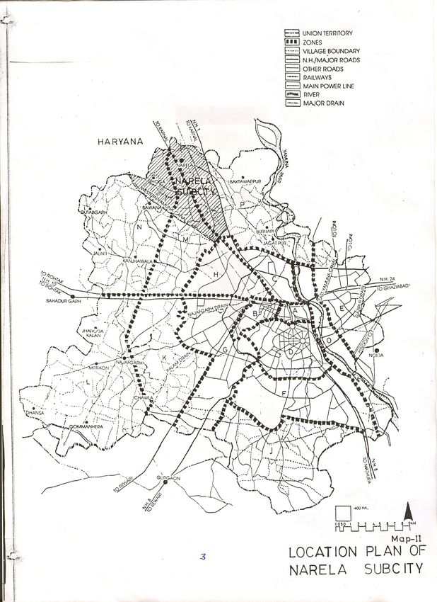
Drawing 1.0: Location plan of Narela Sub-city (Zone P-I)

                                     1
Drawing 2.0: National Capital Territory of Delhi Zones (Divisions)
2ZONAL PLAN OF ZONE P-I (NARELA SUB-CITY)
1.0 INTRODUCTION
1.1 The NCT of Delhi (NCTD) has been divided in 15 planning zones
(divisions) designated from ‘A’ to ‘P’ (except Zone-I) in the Master
Plan for Delhi (MPD) - 2021, P-Zone is further sub divided into two
zones designated on P-I & P-II zones. P-I zone covers an area of
9866 Ha.
1.2 As per MPD-2001 provisions, this zone covers Narela sub-city that
comprises of parts of Zones - M, N and P. It formed part of the urban
extension plan of MPD-2001 approved by the Authority vide
Resolution No. 79 dated 30.6.1987. Hereinafter this zonal plan is
referred to as Zonal Plan of Narela, Zone P-I as per MPD-2021.
2.0 STATUTORY PROVISIONS
2.1 A Zonal Development Plan means a plan for each Zone (Division)
containing information regarding provision of social infrastructure,
parks and open spaces, circulation system etc. The Zonal
Development Plan indicates the actual as well as proposed use
zones designated in the 9 ‘land use’ categories stated in the Master
Plan according to which the area in the Zone is to be finally
developed. User indicated in the Zonal Development Plan will not
give automatic right to the owners to use their property / land for the
designated use. Based on the availability of infrastructure services
by the respective departments, the urbanisable areas will be opened
up for development in a phased manner to meet with the needs of
urbanization envisaged in the Master Plan-2021. The hierarchy of
3Urban Development indicated in the Zonal Development plan is to
be in conformity with table 3.3 of the Master Plan-2021.
2.2 The Zonal Plan of this area stands approved vide MOUD letter no.
K-13011/7/06/DDIB dt. 26.05.2006. However, this has now been
reviewed under the framework of MPD-2021.
2.3 MPD-2021 stipulates that already approved sub-zonal plans in
conformity with master plan shall continue to be operative. The
proposed zonal plan after approval shall supersede the earlier
approved sub-zonal / zonal plans.
3.0 OBJECTIVES
The objectives of the zonal development plan are as under:-
i) As per MPD-2021 this area will be developed as an integrated
part of urban extension with self sufficient and high level of the
services.
ii) This area will cater to all sections of the society in term of
housing and employment.
iii) To provide a comprehensive framework of land/uses as
envisaged in the urban extension plan of MPD-2021.
iv) To retain the green belt as shown in the MPD-2021 land-use
plan.
44.0 LOCATION, BOUNDARIES AND AREA
4.1 P-I zone is located in the North-West of NCTD & the boundaries are
as under :
North: NCTD Boundary
South: Boundaries of Sub-zones C and H
East: G. T. Karnal Road (NH-1)
West: Western Yamuna Canal
4.2 The total area of the zone is 9866 Ha. of which urbanisable area of
the zone is 7365 Ha. The remaining 2501 Ha. is under Green Belt
towards Northern border of NCTD as per the land use plan of MPD-
2021.
5.0 POPULATION AND WORK FORCE
5.1 Population - As per MPD-2021, the urban extension areas are
proposed to be planned with an overall city level density of 250
persons per ha. for urban extensions and based on the area under
consideration the proposed population is to 1.62 million including
that of the existing settlements.
5.2 Work Force - MPD-2021 has anticipated a participation rate of
38.1% and thereby the work-force in the Narela Sub-city works-out
to about 6.2 lakh, due to the location of Industries in the sub-city, the
component of work force works out to be roughly 35-40 %, i.e. in all
a generation of about 6.0 lakh workers.
56.0 PLAN PROVISIONS
6.1 Master Plan for Delhi - 1962
The MPD-62 recommended to develop Narela as one of the ring
towns around Delhi Metropolitan Area (DMA) owing to its location
and development potential. It proposed a township for 60,000 people
with government offices and industry to make the town a self
contained unit. The proposal included the adjoining developments of
Mamurpur village and the development undertaken by the Ministry of
Rehabilitation. Broadly the land use plan for 1753 acres (710 Ha.
approx.) was detailed out with a gross residential density of 50-60
persons / acre. As per the provisions of MPD-62 a Zonal
Development Plan for Narela ring Town / (Zone I-1) was prepared
and approved by the Central Government. Ministry of works and
Housing vide letter No. 11-2/69-UDI dated 10th January 1974. The
land use break up as per approved zonal plan of sub zone I-1 is
annexed at Annexure-I.
6.2 Master Plan for Delhi – 2001
As per MPD-2001, urban area was proposed to be extended about
18000 to 24000 ha. which includes Narela sub-city also.
6.2.1 Zonal Plan of Narela Subcity
Based on the MPD-2001 the zonal plan of this zone (comprising of
part zone M, N & P) covering an area of 9866 Ha. was approved
vide letter No. 13011/7/06/DDIB dated 26.05.2006 with the
proposals as given below:
6i) 3165 ha. of land earmarked for residential use to
accommodate 12 lakh population
ii) For integration of goods movement by road and rail freight
complex is proposed this consist of wholesale market,
chemical market, ware housing, road (truck) and rail transport
terminal, ISBT etc.
iii) To cater to the inter city passenger movement a metropolitan
passenger terminal is provided in the zonal plan.
6.2.2 About 1500 ha. land in this zone has been developed in the form of
various housing category i.e. EWS, LIG, MIG & SFS flats. Approx.
850 nos. of alternative plots for the land owner where land is
acquired. Relocation of slum & JJ squatters from other parts of
Delhi. Macro/Micro level facilities such as hospital, water &
sewerage pumping station, cremation ground, convenient & local
shopping centre, development of roads and about 300 ha. of
Industrial Areas.
6.3 MPD-2021 provisions
MPD-2021 stipulates the holding capacity of the zone to be about
16.2 lakhs.
6.3.1 MPD 2021 has proposed a series of innovative concepts such as:
Local area planning, Redevelopment of villages, unauthorized
colonies and Built up areas, Restructuring around major transport
corridors, metro corridor, a network of green & sports infrastructure
etc. which will be suitably incorporated while preparing the detailed
schemes.
6.3.2 As far as the proposed Green Belt on the periphery of NCTD is
concerned, the plan will have to be developed in such a manner that
7the villages/abadi falling in this belt can be suitably marked and
comprehensive rural development/agriculture development could be
planned in the surrounding areas.
7.0 EXISTING PROFILE AND PHYSICAL CHARACTERSTICS
7.1 The zone P-I is very well connected by major roads and highways &
ideally suited for the urban development. The entire zone area is a
vast expanse of more or less flat terrain with land gradually slopping
towards the south. The area has very large green tree coverage in
the form of orchards, forest (declared as reserved forest) and
farmlands. The whole of sub-city has good natural drainage system
and the area is divided into two drainage basins (i) catchments of
Bawana escape and (ii) catchments of Drain No. 6. Both these
drains have number of subsidiaries spread over the entire sub-city
area holding mainly the rural discharge.
7.2 Other Characteristics:
The significant existing developments in the sub-city are as under:
i) The abadis of 16 villages and two census towns (Alipur and
Narela) fall in the zone. A list of the villages falling in the zone
with their population as per census of India 2001 is annexed
as Annexure-II.
ii) A large number of farmhouses exist in this area. A number of
unauthorized colonies and other developments have also
come up within the zone.
8iii) The major portion of planned development taken up by DDA is
near the Narela Town on acquired land of about 516 ha. for
various uses.
iv) The total area of 477 ha. has been identified for industrial use
zone out of which 247 ha. has already been developed by
DSIDC and is operational.
v) Land for utilities like water treatment plant, roads, ESS, part of
Integrated Freight Complex has been acquired and is being
developed.
vi) Integrated Freight Complex (IFC) covering an area of 397.81
ha. is a major economic and employment generation centre.
8.0 DESTINATION & DEVELOPMENT CATALYSTS TARGETS
8.1 Destination Targets:
i) Narela Industrial Area
ii) Bawana Industrial Area
iii) Metropolitan Passenger Terminal (MPT)
iv) Integrated Freight Complex (IFC)
v) Interstate Bus Terminal (ISBT)
vi) District Center and community Centers, Food & Craft Bazaar
vii) District Sports Center
viii) Integrated Schools, hospitals & Socio-cultural Centers
ix) International Exhibition Center/Trade Conference Center
x) Hi-Tech Park
xi) University Center for research, higher education & colleges
98.2 Development Catalysts:
i) Construction of 100 m. Urban Extension Road (UER) - II, 80 m.
UER-I & III and 60 m. R/W roads for connectivity and opening of
the area.
ii) Extension of Mass Rapid Transit System (MRTS) routes from
Barwala to Bawana and Holambi Kalan station.
iii) Increase in the frequency of shuttle train service between Delhi
and Narela.
iv) Introducing new routes and increasing frequency of existing bus
routes.
v) Relocation of existing grain godowns to the designated
warehousing at IFC.
vi) Relocation of Chemical Market and wholesale markets in IFC.
vii) Development of industrial areas.
8.3 The above would involve certain modifications in the already
approved zonal plan: -
i) To provide a University Center for higher education and
research.
ii) To provide District Sport Centre and Divisional Sport Centre.
iii) To provide an International Exhibition Fair ground along with
trade cum conference center
iv) To explore possibilities of extending MRTS route up to the sub-
city.
108.4 Following are the approved schemes in Narela Sub-city:
i) Sector Plan of A1-A4 for 320 ha. has been approved by the
Screening Committee as high-value residential development
to be developed on group housing basis. The above proposal
was approved by the Screening Committee in its meeting held
in Oct.’2004 which has necessitated relocation of Jail & Court
site, service center site and readjustment of landuse in the
zonal Plan of Narela Sub-city as the land under 3 HT lines
passing through this residential sector which has been
proposed as zonal green.
ii) For water treatment plant to be allotted to DJB, the Technical
Committee in its meeting held on 25.10.04 decided to earmark
35 ha. of land at Narela.
iii) An area of 175 ha. has been notified for “manufacturing” use
vide MOUD notification dt. 01.03.05, DSIDC is developing it.
iv) The realignment of 80 m. UER-I near FCI godown was
approved by the Technical Committee in its meeting held on
12/05/2004. Subsequently the detailed alignment of this 80m
R/W and 100m R/W UER-I & UER-II have been approved
from Technical Committee meeting dt.1/02/2007.
v) Sector plan of G7-G8 covering an area of 299 ha. has been
approved by Screening Committee on 7.1.2007.
vi) Landuse of an area measuring 290.07 ha. has been notified
by the MOUD on 25/01/05 from rural use zone to commercial
and Transportation.
vii) The landuse of an area measuring 1506.89 ha. in the west of
Delhi Karnal railway line upto western Yamuna canal has
been notified by MOUD on 03/01/05 from “Rural” use zone to
11“Residential/ Commercial/ Manufacturing/ PSP/ Recreational/
Utility/ Transportation”.
9.0 PROPOSALS
i) An Education & Research Centre including University has
been proposed at the northern part of the sub-city.
ii) As per MPD-2021 norms, the required number of Petrol Pump
sites/CNG stations in the Narela sub-city works out to be 155.
There are 12 existing sites which include one CNG Mega
station in Narela project, 6 of the existing sites are located on
GT Karnal Road (NH-1) near Singhu Border along the G.T.
Road, which are located in mandatory green belt. The
remaining sites are proposed to be located at layout level as
per prevailing MPD / Guidelines.
iii) The residential pockets for various housing categories are
proposed for an area of 82.0 ha. in Sector A1 – A4. Keeping
this in view, the jail, court complex site, govt. office site
measuring 56 ha. earlier proposed in the approved zonal plan
be shifted in Sector B-3 & B-8 in the north & south of 60m
R/W road near the AIR Khampur with area 16 ha. for jail and
16 ha. for court complex & govt. offices.
iv) The landuse along UER-I, II & III has been readjusted as per
MPD-2021 provision so that facility corridor comprising of
‘Public & Semi-public’ Facility/city level utilization &
commercial use are located along major roads.
v) Development of villages to be integrated with the development
scheme of the area. Around these settlements, education,
health and recreational facilities and other uses would be
developed for the benefit of the local population.
1210.0 LAND USE PLAN
10.1 Following is the proposed land use break-up of this zone:
Table 1.0: Land-use Break Up
Sl. Land Use Area Change of Area Proposed Remark
No. as per Landuse notified (ha) % age
draft MPD-2021 as per
ZDP ZDP
(Zone Area Area P-I,
P-I) Added Subtrac. MPD-
+(ha) -(ha) 2021
1 Residential 3153 11 - 3164 42.95 Shifting of Jail &
addition of
Residential area
under 20 point
programme
2 Commercial 391 - - 391 5.31
3 PSP Facilities 875 - 271.4 603.6 8.2 PSP (AIR Land)
to Recreational
4 Manufacturing 483 - 6 477 6.48 FA-4 shown as
Facility Corridor
as per MPD 2021
5 Utility 327 10.5 - 337.5 4.58 Jal Board's land
shown as Utility
6 Government 16 - - 16 0.22
7 Recreational 1029 261.9 - 1290.9 17.53 PSP (AIR Land),
Utility (WTP) and
utilization of land
under HT line to
Recreational
8 Transportation 1091 - 6 1085 14.73 Reduced 60 m.
R/W road to 30
m. R/W
Total 7365 - - 7365 100
1310.2 Residential Development
10.2.1 Existing Development
The residential development in Narela Sub-city has taken place so
far in the form of various types of DDA Housing i.e. EWS, LIG, MIG
/self financing. A new concept of incremental housing was also
adopted keeping in view of the growing needs of a family. Beside
this the unorganized growth of residential clusters has taken place in
the form of unauthorized colonies, extension of villages etc. The list
of villages is annexed at Annexure - II and unauthorized colonies is
annexed at Annexure - III. A large no. of slum and J.J. population
has also been relocated from the mother city. One pocket in sector
B-2 has also been developed as turn key project for LIG housing.
i) Existing villages & Census Towns - The villages and census
towns are also considered at par as they also have the same
traits. The socio-economic changes in these old unplanned
areas, especially in villages have been substantial. The
redevelopments plans should ensure that the permissibility of
mixed use zoning at property or within the premise level is
compatible to the predominant residential areas.
ii) Unauthorised colonies – The process of regularization of
unauthorized colonies is being coordinated by GNCTD.
Regularization of unauthorized colonies is a continuing
process and is subject to the Government guidelines approved
from time to time. The tentative list of the unauthorised
colonies falling in Zone P-I has been annexed at Annexure-III.
In the case of Village Abadis, the ‘land use’ of the finally
14approved unauthorized colonies located in any use zone, at
any point of time, within the boundaries specified by the
competent authority, would be ‘residential’.
iii) Farm Houses - The Farm Houses were permitted and
sanctioned under the provision of Master Plans 1962 and
2001. As per MPD-2021 the farm houses are now permitted
only in the ‘green belt’. All existing farm houses would be dealt
with as per the Government policy on Farm Houses.
10.2.2 New Housing Areas
The proposed housing strategy incorporates approaches for
development of new housing area, upgradation and re-densification
through re-development of existing housing area including
unauthorized colonies, in view of the limited availability of land and
increased requirement of housing, plotted residential development
shall be discouraged. The sub-city when fully developed will provide
housing facilities to over 3.60 lakh families in all income groups.
Involvement of private sector in development of housing will be
considered as per MPD-2021 provision.
10.2.3 As per MPD-2021, the identification of mixed uses area / street shall
be done as per the Mixed Use Regulations. The mixed use would be
permissible on streets/stretches already notified by the competent
authority. The mixed use areas will be shown in the Local Area
Plans. The list of commercial and mixed land-use streets in Narela
zone as per Notification of GNCTD dated 15.9.07 & 12.4.2007 is
annexed at Annexure – VI & VII respectively. Keeping in view that
15the development of Narela sub-city is yet to come up, MCD may
consider taking forward the list of mixed use & commercial streets.
10.3 Commercial
Shopping and commercial areas reflect the economy and the image
of the city. As required, three District Centers have been proposed
in zone P-I and one remaining site under District Center in IFC will
be utilized for sub-city level whole sale and service market.
The space for informal bazaar and service markets will be reserved
in the District Centers, Community Centers and LSS/CSC.
Integrated Freight Complex (IFC) covering an area of 397.81 ha. is
major economic activity and employment generation centre.
10.4 Public and Semi-Public Facilities
10.4.1 Facility Corridor
In MPD-2021, it is mentioned that for the Zonal Development Plans
of urban extension, the facility belts/corridors shall be detailed out in
Layout Plans. The facility corridors indicated in the Zonal
Development Plan will be detailed out into specific uses as per MPD-
2021 at the time of preparation of detailed layout and Sector Plans
on the basis of feasibility and ground realities. The exact boundary
of facility belts/corridors will thus be governed by the approved
layout plans, wherever applicable.
10.4.2 The requirements of Public and Semi-public facilities (Social
Infrastructure) up to the Zonal Plan level have been identified and
located in various facility areas as per the norms. Each public and
semi-public facility pocket provides a cluster of various community
and above level facilities worked out as per the population of the
16sub-zonal pockets (Annexure - IV). Some of the major facilities
proposed as:
University Centre (1 No), Medical College (2 Nos.), Divisional Sports
Centre (1 No), District Sport Centre (3 Nos.), International Exhibition
cum Fair Ground (1 No), District Jail (1 No).
10.5 Government Offices
An integrated office complex has been proposed in Sector B-3
(16 ha.) which will comprise the offices of GNCTD / local bodies
district court etc.
10.6 Utilities / Physical Infrastructure
10.6.1 Water Supply
The total water requirement of the sub-city works out to be
approximately 120 MGD @ 60 gallons capita per day as per MPD-
2021 norms. A Water Treatment Plant with a capacity of 300 MGD
has been planned which would serve Rohini as well. The water
supply system will consist of underground reservoirs / command
tanks (each for 1.5 to 2 lakh population) inter-connected by water
mains. Each Command Tank will have its own command area. Land
for W.T.P. along Western Yamuna Canal has been identified and
transferred to D.J.B.
10.6.2 Sewerage System
Sewage expected to be generated is 90 MGD. Two STP’s have
been planned. STP-I with a capacity of 20 MGD and STP-II with a
17capacity of 70 MGD system which consist of Gravity main sewage
pumping station and rising mains. The sewage treatment plants are
towards the east of G.T. Karnal Road and are in the process of
development and would take care of requirement of Narela sub-city.
10.6.3 Storm water Drainage
Total discharge is of about 7000 cusecs. The total area falls under
the catchment of Bawana escape and Drain No. 6. There are
number of subsidiary drains such as Bakaner Drain, Sanoth Drain,
Gogha Drain etc which will form major network for carrying the storm
water.
10.6.4 Power
Total requirement: 1400 M.W.
System may consist of 400 KV ESS (1 No. existing) and 220 KV
ESS (5 Nos., 1 already existing) and 66 KV ESS (20 Nos.). The
detailed locations and numbers would be decided in consultation
with concerned agencies at the time of preparation of layout plans.
10.6.5 Solid Waste Management
Total Solid Waste : 840 tons / day. The process of disposal to be
through Sanitary landfills, composting and incineration depending
upon the quality of the refuse. In future emphasis to be laid on solid
waste disposal by more scientific method, where the land
requirement gets reduced to minimum in consultation with the
concerned agencies.
18A site of about 60 ha. for solid waste has been earmarked near
Narela - Bawana industrial area Ph-II.
There is a scope to improve the service delivery by proper
management and coordination. The local bodies and service
agencies may take into account the proposals of zonal plans for
making advance preparation for the provision of services in the
proposed Urban Extension. Alternatives, such as, public private
partnership / joint sector /SPV and privatization may also be
considered with the view to harness all the resources for making
available services in a time bound manner. Decentralization of
services, adoption of new technology and ecological concepts, such
as, watershed planning and better ground water management, zero-
run off drainage, roof top rain water harvesting, recycling, renewable
energy, leakage and waste minimization, etc should be the basis of
services planning and development.
10.7 Industry
10.7.1 An area of 477 Ha. has been proposed for industrial use which
consists of 3 industrial clusters namely (i) Narela Industrial Area in
Ph-1. (ii) Bawana Industrial Area Ph-II. (iii) Bhorgarh Industrial Area.
The planning & development of these industrial areas is dealt by
GNCTD. Besides these, two service centers have been proposed.
10.8 Recreational
10.8.1 About 1290.9 Ha. of land has been proposed for “Recreational” use
which comprises of community, district and sub-city level parks and
play grounds as per the provision of MPD-2021. Land under forests,
drains, HT lines have been proposed for ‘Recreational’ uses apart
19from linear green (Dist. Park) would provide continuity of open space
enhancing the visual and functional quality of built environment as
well as provide for segregated cycle / walking corridors. About
17.53% of land has been proposed in the zonal plan apart from 2501
ha. green belt in the northern fringe of the sub-city. Further local /
neighborhood park / play grounds will be part of the Layout Plan.
Multi-purpose grounds, a category of park/ open grounds for holding
marriages and other special functions has been proposed. Already
approved such sites by the local body/MCD are designated as multi-
purpose grounds.
10.8.2 Environment, Green Belt and Water Bodies
a) Environment
One of the major objectives of the plan is creation of a sustainable
physical and social environment for improving quality of life. There
are two components of urban management – the environment per
se, or the habitat and service management. The following three fold
approval and strategy has been adopted:
i) Management of Natural Resources and the related
environment infrastructure and services in a manner that
would lead to optimization of use of natural resources, and
reduction/ abatement of pollution.
ii) Conservation and Development of the Natural features with a
view to enhancing their environment value; and
iii) Development and preservation of open spaces, green and
landscape / recreational areas.
20b) Water (surface and ground)
The zone has been divided in to two drainage basins (i)
Catchments of Bawana escape and (ii) Catchments of Drain
no.-6 and both these drains have number of subsidiaries
spread over the entire sub-city area holding mainly the rural
discharge.
c) Green / Recreational Area
The zone has very large green coverage in the form of
orchards, forest (declare as reserved forest) and farms lands.
This sub-city covers a green belt of an area of 2501 ha. all
along the northern boundary of the Narela subcity. The other
area under recreational / green use i.e. 1290.9 ha. is in the
form of district parks, city parks, community parks, roads side
green etc. comprising about 17.53% of the total urban land
area.
Two major drains i.e. Drain No-6 and Bawana escape which
are passing through the subcity have been proposed to be
developed as a green corridor. Existing water bodies (1 ha.
and above) are proposed to preserved and developed as
landscape feature. The list of village ponds – Alipur block is
annexed at Annexure- V.
10.8.3 Conservation of Heritage
An old historic tank (Mughal tank) and wall masjid situated in the
revenue estate of village Kuraini has been identified as historical
monuments by INTACH which are to be preserved and a
conservation plan is to be prepared.
2110.9 Transportation / Circulation
10.9.1 Circulation Network
The Zonal Plan indicates circulation network, which is based on
secondary source data. The actual detailed alignment will be with
reference to the actual detailed project report/site survey and thus
may undergo minor modifications at the time of finalizing the road
alignment which will be incorporated in the sector plans/layout plans.
10.9.2 The present circulation system of the sub-city is based on mainly
surface transport i.e. rail and road. The strengthening of the rail
network supported by MRTS would provide major public transport to
the sub-city from the mother city as per details given below:
i) Railway Network
The rail corridor (Broad Gauge Railway Line to Amritsar)
running through the sub-city provides for goods and
passenger movements. The existing railway corridor has
already been electrified for the phased movement of the
commuters as well as the goods from the nearby areas. In
consultation with railways it is proposed to expand the main
corridor to 4 tracks with a metropolitan passenger terminal
near Holambi Kalan.
ii) Road Network
A hierarchy of road network (100m, 80m, 60m and 40m road
right of way) has been proposed. Three major arterial roads
viz UER – I, II & III of 80m, 100m & 80m R/W respectively are
proposed between G. T, Karnal Road (NH-1) to Rohtak Road
22(NH-10) and NH-8 passing through Narela, Rohini & Dwarka
projects. This road system would be further connected by a
hierarchy of collector local roads at the level of Layout Plans.
It is envisaged to segregate the different traffic modes and
roads with green buffer which would also combat the air and
noise pollution in the area. Attempts would be made for
pedestrian and bicycle friendly roads by using modern traffic
calming design to keep the speed within limits as per the
design to provide dedicated cycle tracks for the movement
within the sub-city.
iii) Bus Depots
Apart from the modern rail system, buses will continue to be
other major public transport mode in the city. As per the MPD-
2021 norms, the detailed requirement of Bus terminal & Bus
depots are provided / will be provided with the development of
different phases of development of the city. The new Bus
Terminals need to be planned and developed in strategic
location to make the use of MRTS and Metro station
convenient for all commuters.
iv) MRTS
As recommended in MPD-2021 a link of MRTS has been
proposed from Sanjay Gandhi Transport Terminal to Narela.
However, the exact alignment of the same is to be prepared in
consultation with DMRC. It may be envisaged that the
proposed MRTS corridor from Rithala to Holambi Kalan could
be extended further to Jhangir Puri passing through Zone P-II.
23v) Influence Zone
As per MPD 2021 (Para 3.3.2 (i)), Influence Zone along MRTS
Corridors and the Sub Zones for redevelopment and renewal
will be identified on the basis of physical features such as
metro, roads, drains, high tension lines and control zones of
monuments / heritage areas, etc. This identification will be
done in consultation with GNCTD, wherever applicable.
In Zonal Development Plan the number of colony roads, local
drains, high tension wires, heritage areas etc. are not
indicated. Therefore, boundary of Influence Zone has not been
indicated in the Zonal Development Plan. It will be shown only
in the local area plans, which are more site specific.
vi) Integrated Multi Modal Transport System
The future transport system consist of mix of rail road based
system (IRBT/RRTS corridors as identified in NCR Plan
2021), Bus Rapid transport System and other mass transit
modes on select corridors will be identified as per the needs
from time to time in accordance to prevailing policy.
10.9.3 Petrol Pumps/CNG Station & Gas godowns:
As per Master plan-2021 the provision of Petrol Pump / CNG Station
& Gas Godowns are as follows:
i) Two fuel stations (one petrol pump & one CNG station) 42
per 150 ha of gross residential area : 3165 ha.
ii) Two fuel stations (one petrol pump & one CNG station) 25
per 40 ha of gross industrial area; 483 ha.
24iii) Four fuel stations (two petrol pump & two CNG station) 4
in each freight complex
iv) Four fuel stations (two petrol pump & two CNG station) 12
in each district center: (4 Nos.)
v) Two fuel stations (one petrol pump & one CNG station) 26
in each community center
vi) Two fuel stations (one petrol pump & one CNG station) 42
in each PSP facility area (21 Nos.)
The total no. of 48 gas godowns are required at the rate of three
Gas godowns for 1,00,000 population. The gas godown sites will be
suitably located in the Layout Plans.
10.10 Development Strategy
i) At present, the Govt. of India policy of large scale land
acquisition, development and disposal prevails in Delhi.
ii) The land has to be used as per the approved layout plan
(LOP) and no change of the use premises can be made contrary
to the land ownership together with land use at premise land
even if the plans (MPD/ZDP) permit such use. There is no
automatic conversion of the ‘rural use’ to residential/or any other
urban activity.
iii) After a decision is taken by the Govt. to allow the
betterment/development of private lands, the conversion charges
are to be paid which are leviable on the basis of rates prevalent
on the date of application.
iv) As per Development Code of MPD-2021, the National Capital
Territory of Delhi is divided into 9 Land use Categories and under
Clause 4.0 of MPD-2021 (Page 124) each Category is assigned
number of Use Zones, which shall be further sub-divided into
25required number of Use-premises with or without conditions as
part of the Layout Plans.
v) Clause 2(4) of MPD-2021 defines a Layout Plan indicating
configuration and size of all use premises. As such, without an
approved Layout Plan, the landuse cannot be established for a
premise.
11.0 CHANGE OF LAND USE
The MPD-2021 has been notified by MOUD on 7.2.2007. Care has
been taken not to revise /modify the original land-use distribution
which stands approved vide MPD-2021.
12.0 REGULARIZATION OF EXISTING HEALTH CARE,
EDUCATIONAL, CULTURAL AND RELIGIOUS (INCLUDING
SPIRITUAL) INSTITUTES EXISTING PRIOR TO 1/1/2006 ON
SELF OWNED LAND NOT INCLUDING GRAM SABHA OR RIDGE
LAND
12.1 In pursuance of the Public Notice issued in this regard, the Authority
resolved incorporation & regularization of the above uses/activities in
the ‘Public & Semi Public’ land use category of the Master Plan. The
applications of the existing institutions as listed in the Annexure-VIII
shall be examined as per the Authority resolution and as per the
directions of the Central Government issued from time to time.
However, the regularization of existing institutions located in the
immediate vicinity of notified Ridge/Reserved Forest/Regional Park
shall be subject to finalisation & demarcation of the boundaries of
the aforesaid respective use zones/areas.
2612.2 In case of cultural, health care and educational institutions, the
structures of such institutes as existing as on 1/1/2006, but not
beyond the prevailing relevant provisions of MPD-2021, shall be
considered for regularization. However, in case of the existing
religious (including Spiritual) institutions vis a vis the lands presently
owned by them, regularization shall be subject to the conditions that
a) the built up area in these cases shall not exceed FAR of 15 with
maximum 15% ground coverage; b) shall be confined to the
buildings, which are directly related to the use activities - religious
(including spiritual); c) the structures as existed on 1/1/2006 shall
only be considered; and d) the remaining area shall be kept as
“green area” with no construction to be permitted in future.
The regularization of all the above institutions shall be
confined to those listed in the Annexure-VIII of this plan or those
cases recommended by DDA to the Govt. on or before 8th March,
2010 and shall be undertaken only after ensuring that the change of
the land use u/s 11A of DD Act, 1957 is notified in conformity with
the provisions of MPD-2021 as and where required. This is further
subject to the condition that such individual cases shall not be
considered for regularization, if the site in question is located:
a) on public / Govt. land; or on land acquired by DDA;
b) on encroached land; or on illegal occupied land;
c) In notified or reserved forest area;
d) In area of right of way infrastructure such as of existing /
proposed railway lines / master plan roads, major trunk water
supply and sewerage lines etc;
27e) Or if it violates the provisions of the Ancient Monuments and
Archaeological Remains Act, 1958, amended from time to
time;
f) Or in cases where there is a Court Order restraining change of
land use of for eviction / vacation of premises.
12.3 Further, regularization orders of these categories of institutions shall
not be considered as approved, unless the requisite payment of
penalty / levy / additional FAR charges etc. are deposited by the
applicant institutes; all the conditions prescribed by the Govt. are
fulfilled and formal 'regularization orders' are issued by the DDA.
None of the above institutes shall be entitled to put the land to any
other use at anytime and doing so shall invite takeover of land by the
DDA for alternative uses, on payment of reasonable compensation
(Annexure – VIII).
28ANNEXURE - I
LAND USE BREAK UP AS PER APPROVED ZONAL PLAN OF SUB
ZONE I-1 (Narela Town)
S. No. Description Phase I (Area in Hectares
Acres)
1. Residential Area 518.00 209.63
2. Industrial Area 501.2 202.84
3. District Centre 34.0 13.76
4. Existing Mandi 10.0 4.04
5. Master Plan Roads 25.2 10.20
6. Transport Center 18.0 7.28
7. Railway Station 16.0 6.48
8. Agriculture land 727.5 294.41
9. Existing Tank 14.0 5.66
10. Hospital 20.0 8.09
11. Police Station 4.0 1.62
12. College 34.0 13.76
13. Existing Canal 2.0 0.81
14. Community Center 22.0 8.00
15. Master Plan Green 70.0 28.33
Total 2015.00 815.81
29ANNEXURE - II
VILLAGES/CENSUS TOWNS IN NARELA SUBCITY
S. Name of the Village / Towns Population (2001)
No.
1. Alipur (Cesus Town) 16631
2. Bakaner 21089
3. Bhorgarh 5562
4. Budhpur – Bijapur 3414
5. Holambi Kalan 3876
6. Holambi Khurd 2705
7. Iradat Nagar Alias Naya bans 2509
8. Khera Kalan 6690
9. Khera Khurd 8817
10. Kureni 2586
11. Mamurpur 3465
12. Narela Census Town 38848
13. Sanoth 2909
14. Shahpur Garhi 959
15. Singhola 1878
16. Sirsapur 15043
17. Tikri Khurd 8637
18. Razapur Kalan NA
Source: Census of India, 2001.
30ANNEXURE - III
TENTATIVE LIST OF UNAUTHORISED COLONIES IN ZONE P-I
S. NO. NAME OF UNAUTHORIZED COLONY REGN. NO.
1. Rajiv Colony, Harijan Basti, Narela, Delhi-40. 743
2. Rajiv Colony Extn., Narela, Delhi-40. 593
3. Shiv Mandir Colony, Safiabad Border, Narela, Delhi-40. 574
4. Gautam Colony Extn., Arya Nagar, Safiabad Road, Delhi-40. 278
5. Sanjay Colony, Narela, Delhi-40. 607
6. Ambedkar Colony Exnt. Part-II, Bakner. 25
7. Gautam Vihar Colony, Narela, Delhi-110040. 371
8. Basti Bakner, North Phirni Road, Narela, Delhi-40. 502
8(A).
Basti Bakner near Bharoda Puna, Shamshan Ghat Road, Village Bakner, Narela, Delhi-110040.
8(B). Basti Bakner near Bharoda Puna, Shamshan Ghat Road, Extended Portion) Village Bakner, Narela,
Delhi-110040.
9. Basti Bankner, South Lampur Road, Delhi-40. 529
10. Amedkar Colony, Bankner Extn., Narela, Delhi-110040. 501
11. Khera Kalan & Khera Garhi Extended Abadi P.O. Khera Kalan. ELD-76
12. Om Vihar Colony, Lampur Road, Narela, Delhi-40 . 1028
13. Nai Basti, Lampur, Narela, Delhi-40. 445
14. Swatanra Nagar Extn. West, Gonda Road, Narela, Delhi-40. 577
15. Swatantra Nagar, Left Out Pocket, Phase-II, Narela. 197
15 (i)
LOP of Swatantra Nagar, Narela, Left out portion (Part-I).
15(A)
15 (B) Swatantra Nagar (Left out Pockets) Narela, Delhi-40 (Phase-II).
Swatantra Nagar Phase-II Left out portion.
16. Nai Basti Kurani, Narela, Delhi-40. 627
17. Shyam Kunj Colony, Tikri Khurd, Delhi-40. 856
18. Mahavir Colony, Alipur Road, Bhorgarh, Narela, Delhi-110040 . 819
19. New Colony Sanoth, Ghoga More, Narela, Bawana. 200
20. Sanoth Extn. Park-I, II & III, Narela Delhi-41. 1196
21. Vashu Vihar Colony, Holambi Kalan, Delhi. 20
22. Ankur Vihar Colony, Holambi Kalan. 21
23. Gautam Vihar Colony Extn., Narela, Delhi-40. 1495
24. Bhaght Singh Park, Siraspur, Delhi-42. 337
25. Bhaght Singh Park Extn., Siraspur Village, Delhi-42 1225
26. Chander Park, G. T. Karnal Road, Siraspur, Delhi-42. 639
27. Jeewan Park, Siras Pur, Delhi-42. 758
28. Rana Park, Siraspur, Delhi-110040. 421
29. Rana Park, Siraspur. 418
30. Hazari Park, Holambi Kalan, Delhi-82. 442
31. Siraspur Extn. Abadi Part-II, Delhi-110042. ELD-72
3132. Harijan Basti, Siraspur, Samaypur Badli, Delhi-42. 642
33. Village Siraspur, Part-I, Delhi-110042. ELD-71
34. Tikri Khurd Village, Extended Abadi, Narela, Delhi-40. ELD-19
35. Tikri Khurd, Village Tikri Khurd, Delhi-40. ELD-135
36. Mamurpur Krishna Nagar, Singhu Border, Narela. 153
37. Krishna Estate ‘G’ Block, Punjabi Colony, Narela. 1574
38. Ravi Dass Colony, Narela. 1551
39. Prem Colony, Bawana Road, Narela, Delhi-40. 50
40. Vishal Enclave, Bawana Road, Narela, Delhi-40. 1194
41. Khera Khurd Extn. Village Khera Khurd, Delhi. 1383
42. Sapt Rishi Garden, Holambi Kalan, Narela, Delhi-82. 343
43. Nai Basti, Bakner Paschim, Delhi. 1292
44. Mann-Enclave, Village Khera Khurd, Delhi-110082. 1029
45. Village Ghoga Extn., Delhi-39. ELD-116
46. Jeet Ram Colony, Budh Pur Distt, North West Delhi.. ELD-01
47. Holambi Khurd Extn., Delhi-110082. ELD-45
48. Khera Khurd Extn. Khera Khurd, Delhi-82. ELD-118
49. Village Khera Kalan, Delhi-82. ELD-77
50. Ghoga Extension village Ghoga 1411
51. Raja Vihar Colony, Siraspur, Delhi-110042. 107
Source :- The list is in accordance with 1639 unauthorised colonies 2007-08, GNCTD
32ANNEXURE - IV
DETAILS OF FACILITY AREAS
S. No. Name of Facility Areas Area (In Ha) Facility Proposed
1. FA-1 10.0 2 Proposed College, Hospital,
Medical College
2. FA-2 49.0 Hospital ‘A’, Police Station, Working
Women Hostel
3. FA-3 9.0 Hospital ‘C’, Hospital ‘D’, 2
(Maternity Hospital, Nursing Home),
1 Community Hall, 1 ESS 66 KV,
Hospital. ‘A’, Fire Station
4. FA-4 4.0 Institutional plots
5. FA-5 40.0 Hospital ‘C’, Hospital ‘D’, 2
(Maternity Hospital, Nursing Home),
1 Community Hall, 1 ESS 66 KV,
Vet (h), Vocational Traning, Police
Station, Veterinary Institute
6. FA-6 32.0 Hospital ‘C’, Hospital ‘D’, 2
(Maternity Hospital, Nursing Home),
1 Community Hall, 1 ESS 66 KV,
Hos. ‘B’, Vocational Traning, Fire
Station, Care Centre for physically
challenged orphanage, Children
Centre, Old Age Home, Religious
Centre
7. FA-7 21.0 Hospital ‘C’, Hospital ‘D’, 2
(Maternity Hospital, Nursing Home),
1 Community Hall, 1 ESS 66 KV
8. FA-8 51.0 All India Radio
9. FA-9 54.0 Hospital ‘C’, Hospital ‘D’, 2
(Maternity Hospital, Nursing Home),
1 Community Hall, 1 ESS 66 KV,
Hospital ‘A’, Vocational Traning,
Fire Station, Care Centre for
physically challenged, Working
Women Hostel, Head Post Office,
Telephone Exchange, Old Age
33Home
10. FA-10 56.0 Hospital ‘C’, Hospital ‘D’, 2
(Maternity Hospital, Nursing Home),
1 Community Hall, 1 ESS 66 KV,
Religious Centre, Science Centre
11 FA-11 26.0 Hospital ‘C’, Hospital ‘D’, 2
(Maternity Hospital, Nursing Home),
1 Community Hall, 1 ESS 66 KV,
Hospital ‘B’, Police Station, Fire
Station
12 FA-12 9.7 All India Radio
13 FA-13 18.0 Hospital ‘C’, Hospital ‘D’, 2
(Maternity Hospital, Nursing Home),
1 Community Hall, 1 ESS 66 KV,
Fire Station
14 FA-14 50.0 Hospital ‘C’, Hospital ‘D’, 2
(Maternity Hospital, Nursing Home),
1 Community Hall, 1 ESS 66 KV,
Hospital ‘B’, Professional Collages,
Police Station
15 FA-15 37.0 Hospital ‘C’, Hospital ‘D’, 2
(Maternity Hospital, Nursing Home),
1 Community Hall, 1 ESS 66 KV,
Vet (h), Fire Station
16 FA-16 42.3 Hospital ‘C’, Hospital ‘D’, 2
(Maternity Hospital, Nursing Home),
1 Community Hall, 1 ESS 66 KV,
Police Station
17. FA-17 60.0 Hospital ‘C’, Hospital ‘D’, 2
(Maternity Hospital, Nursing Home),
1 Community Hall, 1 ESS 66 KV,
Hospital ‘A’, Fire Station, Care
Centre for physically challenged,
International Convention Centre,
Exhibition Cum Fair Ground
18. FA-18 20.0 Institutional & Facility plots
19. FA-19 20.0 Hospital ‘C’, Hospital ‘D’, 2
(Maternity Hospital, Nursing Home),
1 Community Hall, 1 ESS 66 KV
3420. FA-20 39.0 Hospital ‘C’, Hospital ‘D’, 2
(Maternity Hospital, Nursing Home),
1 Community Hall, 1 ESS 66 KV,
Hospital ‘B’, Fire Station, Working
Women Hostel Orphanage,
Children Centre, telephone
Exchange, Old Age Home
21. FA-21 29.0 Institutional plots
22. FA-22 115.0 Hospital ‘C’, Hospital ‘D’, 2
(Maternity Hospital, Nursing Home),
1 Community Hall, 1 ESS 66 KV,
Fire Station, University Campus,
Medical College, Distt. Office &
Battalion, Police Lines
23. FA-23 16.0 JAIL
24. FA-24 29.0 Hospital ‘C’, Hospital ‘D’, 2
(Maternity Hospital, Nursing Home),
1 Community Hall, 1 ESS 66 KV,
Hospital ‘B’, Vet (h), Police Station,
Fire Station, Orphanage, Children
Centre, Fire Training Institute,
Disaster Management
25 FA-25 23.0 Divisional Sports Complex
35ANNEXURE - V
LIST OF VILLAGE PONDS – ALIPUR BLOCK
Sl. No. Name of the village / No. of Ponds Land Surface Area
Census town (CT) Ownership (Sq.Mt.)
1 Bankner A BDO 9,000
B BDO 7,000
2 Lampur A BDO 3,500
3 Sanoth A BDO 25,000
B BDO 25,000
C BDO 2,500
4 Holambi Khurd A BDO 2,500
B BDO 4,500
5 Naya Bans A BDO 1,800
B BDO 2,500
6 Narela A BDO 2,500
B BDO 3,000
Mughal Tank C BDO 4,000
Source :- MCD
36ANNEXURE - VI
LIST OF STREETS FOR COMMERCIAL USE IN NARELA ZONE (as
per notification dt. 15.9.2006)
Sl. Name of the Road/Street Stretch of Road From – To ROW (Mtrs)
No.
1. Arya Samaj Road Ram Dev Chowk to Y Turn 18
2. Narela – Lampur Road t. Point to Railway X-ing 24
LIST OF COMMERCIAL STREETS IN NARELA ZONE (as per
notification of GNCTD dt. 12.4.2007)
Stretch
Sl. Name of the Road/Street R.O.W
No. (In Mtrs)
From To
1. Main Swatantar Nagar Bawana Narela Lampur 9.00
Road Narela Road Road
Plot No.68 Plot No. 2152 only 30.00
northern side
2. Narela Bawana Road H. No. 2142 Railway Boundary 30.00
Ram Dev Railway crossing 30.00
Chowk Bawana Road
Swami Railway crossing 30.00
Swaroopanan
Chaudhary Meer Sing Marg Narela Bankner Railway 13.00
Bawana crossing
Road
3. Punjabi Colony Road Physical Govt. Girls Sr. Sec. 7.00
Centre School
37ANNEXURE - VII
LIST OF MIXED LANDUSE STREETS IN NARELA ZONE (as per
notification of GNCTD dt. 12.4.2007)
Stretch
Sl. Name of the Road/Street R.O.W
No. (In Mtrs)
From To
1. Hawaldar Mukhtyar Singh End of Park Main Auchandi 6.00
Road Bawana
2. Shivaji Nagar Road MCD Park L Point of Plot No. 6.00
73 only eastern
side
38ANNEXURE - VIII
THE LIST OF THE APPLICATIONS OF PRE-EXISTING INSTITUTIONS
(OWNING LAND) & RENDERING CULTURAL, RELIGIOUS (INCLUDING
SPIRITUAL), HEALTH CARE AND EDUCATIONAL SERVICES IN
RESPONSE TO THE PUBLIC NOTICE ISSUED BY M.P. SECTION ON
01.05.08:
S. No. Name & Address
1. Apollo Convent School, Holambi Kalan, Delhi-110082.
2. Bharatmata Saraswati Bal Mandir Sr. Sec. School, Narela,
Delhi-110042.
3. Indian Kids Public School, Gautam Colony, Gali No.8, Main
Sabiabad Road, Narela, Delhi-110040.
4. Radha Swami Satsang Beas, Village Mamurpur, Singhu Border.
5. Moga Devi Minda Charitable Trust, Minda Bal Gram at Holambi
khurd more, Alipur, Delhi-110036.
6. DIRD, Holambi Khurd, Delhi-110082.
7. Kaushlaya Rani Home for the aged blind village Bhorgrah, Delhi-
110040.
8. Sant Ganga Ram Convent School, Ghoga, Delhi-110039.
9. Happy Child Public School, Balwant Singh Memorial Welfare &
educational Socity (Regd.), H. No. 29, Khera Garhi, Delhi-
110082 (Siras Pur Road).
10. Rishikul Vidayapeeth, Alipur, ALipur Road, Delhi-110036.
11. Amba Anand Jyoti Education Society, Village Mamurpur, New
Delhi-110040.
12. Sukriti World School, Jai Mann Education & Charitable Society,
Khera Khurd, Delhi-110082.
13. Kasturi Ram College of Higher Education, Village Kurani,
Narela, Delhi.
14. Ruhani Satsang Prem Samaj, Village Mamurpur,
15. Maharaja Agarsain Public School, Bawana, Village Bhoor Garh,
Narela.
Note: Regularization of above institutions would be subject to examination by
Zonal Committee and further processing for approvals as per Authority
resolution dated 10.04.2008, and fulfillment of all the conditions contained
in the Government directions in letter no. K-12011/23/2009-DDIB dated
the 8th March 2010 from MOUD, Govt. of India. Some of such facilities
although indicated on plan as existing facilities shall not become part of
use zone till the competent authority approve it, subject to fulfillment of all
the conditions.
39You can also read