Tamar Fire Management Area
Bushfire Risk Management Plan
2020
←
→
Page content transcription
If your browser does not render page correctly, please read the page content below
Tamar Fire Management Area Bushfire Risk Management Plan 2020
Document Control
Document History
 Version                Date                   Author                 Section

 V1                     2019                   Steve Summers

Agency Endorsements
 Agency                 Name & Title           Signature              Date

Document Endorsement
Endorsed by Tamar Fire Management Area Committee

Accepted by State Fire Management Council

Ian Sauer
Chair, SFMC
Date: 11/06/2020

Cover Page Photo Acknowledgement: Fuel Reduction Trevallyn, Steve Summers

                                                                                                Page 2 of 30
                                                                    Tamar Bushfire Risk Management Plan 2019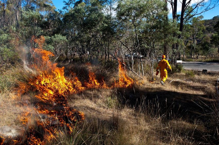
Contents
Glossary ................................................................................................................................................. 5
Acronyms .............................................................................................................................................. 7
Executive Summary ................................................................................................................................ 8
1.     Introduction ................................................................................................................................. 10
      1.1 Background .......................................................................................................................................10
      1.2 Purpose of this plan ..........................................................................................................................10
2.     Establishing the context ................................................................................................................ 11
      2.1 Description of the Tamar Fire Management Area............................................................................11
      2.2 Fire environment ..............................................................................................................................11
      2.3 Population and community ..............................................................................................................14
      2.4 Community engagement ..................................................................................................................15
3.     Identifying the risks ...................................................................................................................... 16
      3.1 Bushfire and impact scenarios..........................................................................................................16
      3.2 Statewide controls ............................................................................................................................16
      3.3 Fire Management Area controls.......................................................................................................16
4.     Analysing and evaluating bushfire risk........................................................................................... 17
      4.1 Analysing bushfire risks ....................................................................................................................17
      4.2 Evaluating bushfire risks ...................................................................................................................17
5.     Bushfire risk treatment ................................................................................................................. 18
      5.1 Treatment plan .................................................................................................................................18
      5.2 Implementing treatments ................................................................................................................18
      5.3 Strategic fire infrastructure ..............................................................................................................18
      5.4 Fuel reduction burning .....................................................................................................................18
6.     Monitoring and review ................................................................................................................. 19
      6.1 Review ..............................................................................................................................................19
      6.2 Monitoring and reporting .................................................................................................................19
References ........................................................................................................................................... 20
Appendices .......................................................................................................................................... 21
      Appendix 1: Treatment plan .....................................................................................................................21
      Appendix 2: Current implementation plans .............................................................................................26

                                                                                                                                           Page 3 of 30
                                                                                                               Tamar Bushfire Risk Management Plan 2019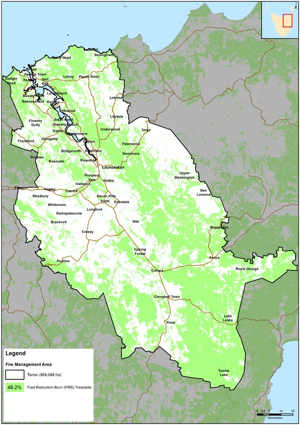
Maps ................................................................................................................................................... 27
      Map 1: Tamar Fire Management Area location .......................................................................................27
      Map 2: Tenure summary map for Tamar Fire Management Area ...........................................................28
      Map 3: Fuel treatability for Tamar Fire Management Area .....................................................................29
      Map 4: Vegetation for Tamar Fire Management Area .............................................................................30

                                                                                                                                           Page 4 of 30
                                                                                                                         Bushfire Risk Management Plan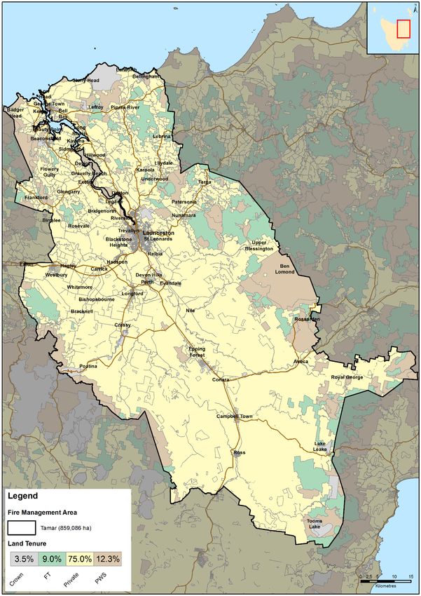
Glossary

Glossary
Asset               A term used to describe anything valued by the community that may be
                    adversely impacted by bushfire. This may include houses, infrastructure,
                    agriculture, production forests, industry, and environmental and heritage sites.
Asset Zone (AZ)     The geographic location of asset(s) and values of importance requiring bushfire
                    exclusion.
Asset Protection    An area adjacent to or near Asset Zones, the primary management purpose of
Zone (APZ)          which is to protect human life, property and highly valued assets and values.
                    Treatment can include intensive fuel reduction, manipulation of fuel moisture or
                    response plans.
Bushfire            Unplanned vegetation fire. A generic term which includes grass fires, forest fires
                    and scrub fires both with and without a suppression objective.
Bushfire hazard     The potential or expected behaviour of a bushfire burning under a particular set
                    of conditions, i.e. the type, arrangement and quantity of fuel, the fuel moisture
                    content, wind speed, topography, relative humidity, temperature and
                    atmospheric stability.
Bushfire risk       A systematic process to coordinate, direct and control activities relating to
management          bushfire risk with the aim of limiting the adverse effects of bushfire on the
                    community.
Community           A bushfire plan for community members that provides local, community-specific
Bushfire            information to assist with bushfire preparation and survival. The focus of the
Protection Plan     Bushfire Protection Plan is on bushfire safety options, and the intent of the plan
                    is to support the development of personal Bushfire Survival Plans.
Community           An Emergency Management Plan for emergency managers and responders. The
Bushfire Response   Bushfire Response Plan aims to better protect communities and their assets
Plan                during bushfire emergencies, through the identification of protection priorities
                    and operational information.
Consequence         Impact(s) of an event on the five key areas: environment, economy, people,
                    social setting and public administration.
Control             A measure that modifies risk. This may be an existing process, policy, device,
                    practice or other action that acts to minimise negative risk or enhance positive
                    opportunities.
Fire management     Classification system for the areas to be managed. The zoning system indicates
zoning              the primary purposes for fire management for an area of land.
Fuel break          A natural or manmade change in fuel characteristics which affects fire behaviour
                    so that fires burning into them can be more readily controlled.
Hazard              The area between a building and the bushfire-prone vegetation that provides
management area     access to a fire front for firefighting, which is maintained in a minimal fuel
                    condition and in which there are no other hazards present that will significantly
                    contribute to the spread of a bushfire.
Human Settlement    Term given for the dataset used to define where people live and work. The
Area                dataset was developed for the purpose of risk modelling and was created using a
                    combination of building locations, cadastral information and ABS data. Includes
                    seasonally populated areas and industrial areas.

                                                                                                     Page 5 of 30
                                                                         Tamar Bushfire Risk Management Plan 2019
Glossary
Land Management An area that is managed to meet the objectives of the relevant land manager
Zone (LMZ) such as: Traditional Owner practices, biodiversity conservation, production
forestry, farming or recreation. Management can include planned burning,
experimental treatments, fire exclusion or no planned action.
Likelihood Chance of something happening. It is used as a general description of probability
and may be expressed qualitatively or quantitatively.
Risk register A document usually presented in a tabular form which lists concisely the
following information for each risk: the risk statement, source, hazard, impact
area, prevention/preparedness controls, recovery/response controls, level of
existing controls, likelihood level, risk level, confidence level and treatment
strategy.
Risk treatment Process of selection and implementation of controls to modify risk. The term ‘risk
treatment’ is sometimes used for the controls themselves.
Strategic Fire An area located close to or some distance away from assets (e.g. the urban–rural
Management Zone interface), the primary management purpose of which is to provide a mosaic of
(SFMZ) areas of reduced fuel in strategic locations to reduce the speed and intensity of
bushfires, potential for spot-fire development, and size of bushfires. Treatment is
by fuel reduction burning and other bushfire protection measures such as fire
trails, water points, detection measures and response plans.
Treatable Types of vegetation which are suitable for fuel reduction burning, for example,
vegetation dry eucalypt forest, scrub, heathland and button grass.
Treatment plan A document related to the risk register presented in a tabular form which lists
concisely the following information for each risk: the agreed strategies to
manage the risk (i.e. treatments), the responsible organisations, proposed
completion date and comments.
Page 6 of 30
Tamar Bushfire Risk Management Plan 2019Acronyms
Acronyms
HSA Human Settlement area
BRU Bushfire Risk Unit
BRMP Bushfire Risk Management Plan
DPIPWE Department of Primary Industries, Parks, Water and Environment
FFDI Forest Fire Danger Index
FMA Fire Management Area
FMAC Fire Management Area Committee
LGA Local Government Area
PWS Parks and Wildlife Service
SFMC State Fire Management Council
STT Sustainable Timber Tasmania
TFS Tasmania Fire Service
Maps contained in this document may include data provided by DPIPWE (Land Tasmania), Parks and Wildlife
Service (Fire Management Section) and Tasmania Fire Service. These map products have been produced by
the Tasmania Fire Service. While all efforts have been taken to ensure their accuracy, there may be errors
and/or omissions in the data presented. Users of these products are advised to independently verify data for
accuracy and completeness before use.
Page 7 of 30
Tamar Bushfire Risk Management Plan 2019Executive Summary
Executive Summary
This Bushfire Risk Management Plan identifies priorities for the treatment of bushfire risk in the Tamar Fire
Management Area. It was developed by the Fire Management Area Committee (FMAC) as required under
sections 18 and 20 of the Fire Service Act 1979. This plan aims to coordinate and influence the treatment of
bushfire risk in the Fire Management Area.
The plan is strategic level and does not include all details of bushfire risk treatments, but does identify which
organisations or individuals are responsible for implementing them. The Tamar FMAC will prepare a written
report at least yearly for the State Fire Management Council on the progress of implementation.
The Tamar Fire Management Area (FMA) is located on the north coast of Tasmania and encompasses
Launceston City, the Tamar River Estuary and the Northern Midlands plains. The FMA covers an area of 859
086 ha and is a mixture of lands with high conservation value or lands with a high agricultural value. The
region is dominated by agricultural and pastoral activities, particularly meat production, wool production,
apples, berries and viticulture, with the Tamar Valley being one of Tasmania’s leading wine producing areas.
Tourism, manufacturing and mineral exploration are also important industries for the region.
An estimated population of 106,000 reside within the Fire Management Area with several major population
centres including Launceston, Beaconsfield/Beauty Point, George Town, Hadspen, Legana, Longford, Perth
and Westbury.
Fire is an integral component of the Australian landscape and has the potential to impact all aspects and
values of the FMA. Historical records have indicated that fire ignitions have been predominately human
based though dry lightning events has ignited fires within the FMA. Changing climatic conditions are
predicted to lead to more extreme fire weather events increasing the fire risk to the communities and assets
within the FMA.
Understanding of the risk is essential to managing fire in the landscape. This interim document examines
and identifies areas that are of a high priority for the treatment of fire risk. The treatment plan (Appendix 2)
lists the actions determined by the FMAC required to treat bushfire risk in the Fire Management Area.
Areas that the FMAC have considered to be a priority for treatment are the East and West Tamar ridges
(either side of the Tamar Estuary. These ridges have the potential to lead fires into the major population
centres or impact minor communities.
Treatment options to reduce risk within the FMA may include:
• Development of appropriate fire management zoning including assets protection zoning;
• Development and the implementation of fuel reduction programs adjacent to the communities at risk
including planned burning;
• Development of fire infrastructure including fuel breaks and access tracks adjacent to communities
under risk;
• Community consultation and engagement including community education initiatives.
Page 8 of 30
Tamar Bushfire Risk Management Plan 2019Executive Summary
Implementation of the treatment plan may be constrained by:
• Resource availability to implement appropriate management activities such as fuel break construction;
• Appropriate windows in the weather may not exist to carry out planned burns;
• the management of fire risk on private land is a considerable challenge for the Tamar FMA;
• Agreement with all stakeholders as to the proposed works.
Future iterations of this document will be based on an expanded risk profile based around likelihood and
consequences together with an understanding of the confidence in the data.
Page 9 of 30
Tamar Bushfire Risk Management Plan 2019Introduction
1. Introduction
1.1 Background
It is a requirement of Section 20 of the Fire Service Act 1979 that the Fire Management Area Committee
(FMAC) prepare a fire protection plan for its Fire Management Area. This Bushfire Risk Management Plan
(BRMP) fulfils that requirement. The BRMP is submitted to and approved by the State Fire Management
Council (SFMC).
The Fire Service Act 1979 requires that the fire protection plan is consistent with the State fire protection
plan and the State vegetation fire management policy.
Under the terms of reference for the Tamar FMAC, the purposes of the committee are:
• Provide a forum for communication and collaboration between key stakeholders in the FMA
• Enable a holistic and consistent approach, incorporating local knowledge, to identify strategic priorities
to reduce bushfire risk
• Coordinate efforts and facilitate resource sharing to implement the strategic risk reduction priorities
• Link the local community and the SFMC through ‘ground-truthing’ the bushfire risk assessment and
mitigation strategies
• Through their advisory function, provide input into decisions and outcomes beyond the Fire
Management Area.
1.2 Purpose of this plan
The management of bushfire-related risk is a collective responsibility of the whole community, with
contributions made by numerous individuals, landowners and organisations.
An overriding aim of this BRMP is to document a coordinated approach to the identification and treatment
of bushfire risk in the Tamar Fire Management Area (FMA). Specific objectives include:
• Guide and coordinate bushfire risk management on all land within the FMA
• Provide a reference point for the prioritisation and justification of bushfire treatment actions, as well
as supporting evidence for funding requests
• Facilitate the integration of bushfire risk management into the business processes of councils,
organisations and land managers
• Facilitate cooperation and the coordination of treatment actions between stakeholders
• Clearly and concisely communicate bushfire risk to stakeholders and the community
• Provide a basis for monitoring and reporting of implementation of bushfire risk treatments in the FMA
This BRMP is a strategic-level document that does not provide detail on treatment actions. Individual
organisations and landowners, or collaborative groups, may have developed plans and processes for
implementation of bushfire risk treatment; these can be considered to be linked to the strategic priorities
identified here. This is an interim version of the BRMP – future versions will be based on a more
comprehensive risk assessment.
Page 10 of 30
Tamar Bushfire Risk Management Plan 2019Establishing the context
2. Establishing the context
2.1 Description of the Tamar Fire Management Area
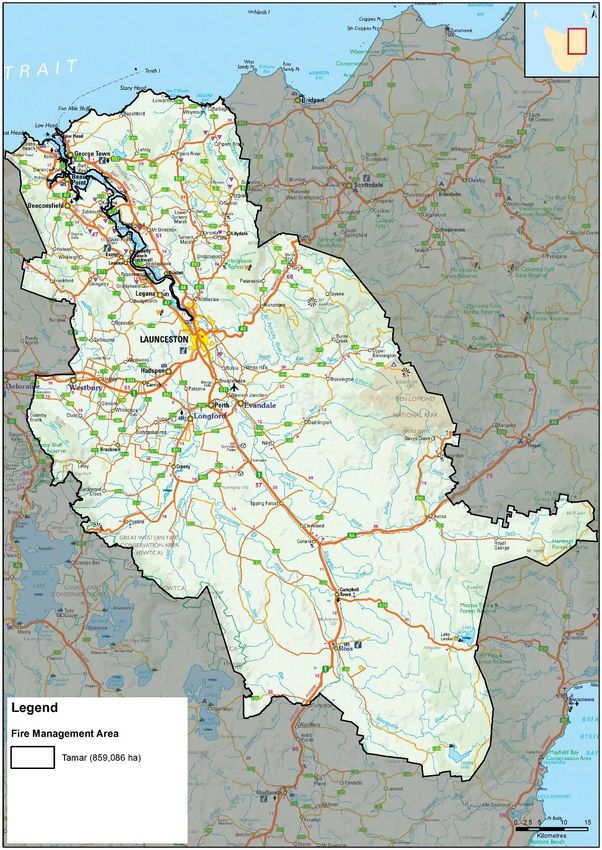
The Tamar Fire Management Area is located in the north of Tasmania (Map 1). Located around the city of
Launceston, the FMA encompasses the Tamar estuary and the Northern Midlands plains. The FMA covers an
area of 859 086 ha. Central to the FMA is the Tamar Valley and Esk River (North and South) systems.
The Tamar Fire Management Area straddles the Midland Highway which is the primary road route to and
from Hobart in the south. It also straddles the Bass Highway between Launceston and Westbury.
Land tenure within the Tamar FMA is approximately 25% public land and 75% private/freehold land (Map 2).
Land Manager/Agency % of Land Managed within the
FMA
Private 75 %
DPIPWE (including Parks and Wildlife Service and Crown land Services) 15.8 %
Sustainable Timbers Tasmania 9%
HydroEstablishing the context
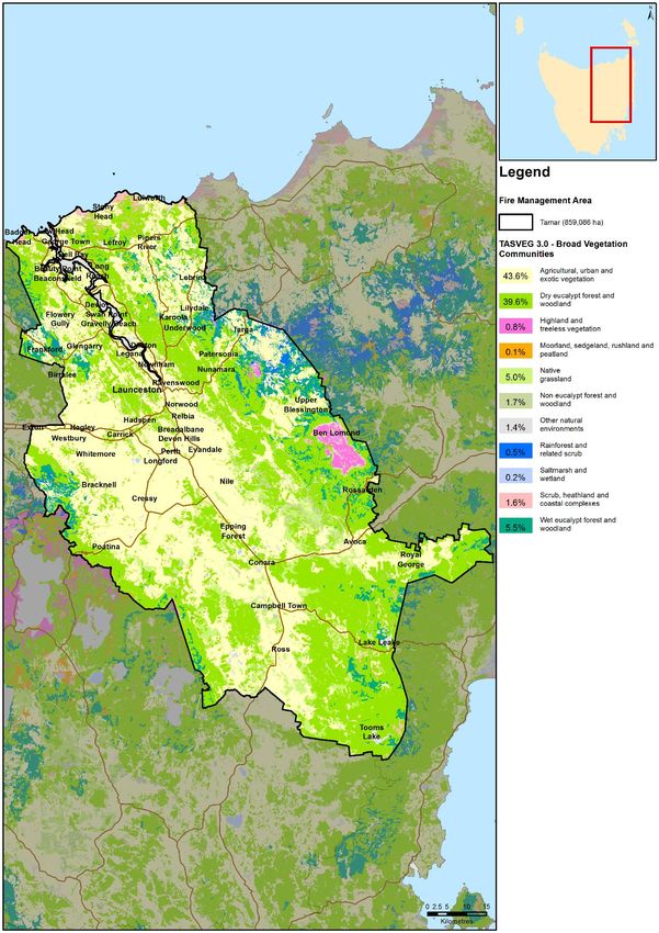
Broad Vegetation Group (TasVeg 3, 2013) (ha) % in FMA Veg Flammability
Agricultural, urban and exotic vegetation 374576 43.6 Medium
Dry eucalypt forest and woodland 340014 39.6 Medium - High
Highland and Treeless Vegetation 6684 0.8 High
Moorland, sedge land, rush land and peatland 466 0.1 Low – Very High
Native grassland 42879 5.0 High
Non eucalypt forest and woodland 14899 1.7 High
Other natural environments 11761 1.4 N/A
Rainforest and related scrub 4655 0.5 Low
Saltmarsh and wetland 1758 0.2 Low
Scrub, heathland and coastal complexes 13615 1.6 High – Very high
Wet eucalypt forest and woodland 4733 5.5 Medium
Total 816040 100
Table 2: Broad vegetation Groups Tamar FMA
Vegetation can also be classified as treatable or untreatable which is an important consideration for fuel
reduction burning purposes. Agricultural lands while susceptible to fire, are not included in the treatable
vegetation group due to the land use priority allocated to this vegetation type. Currently 42.8 % of the FMA
is classified as treatable vegetation and is highlighted in Map 3. A breakdown of the classification of treatable
vegetation is detailed in table 3:
Fuel Reduction Burning Treatability – Tamar Fire Management Area
Tamar Area (ha) (%)
Treatable 428356 49.9
Un-treatable 130608 15.2
Agricultural Land* 292587 34.1
Water 7041 0.8
Not Mapped 495 0.1
Table 3: Treatable vegetation- Tamar FMA
The climate of the Tamar Fire Management Area can be classified as temperate and is characterised by wet
winters and low summer rainfall. Terrain, distance from the coast and the rain shadow of the Central Plateau
has a strong influence on the pattern of rainfall across the FMA. Minimum and maximum temperatures are
also cooler and warmer (respectively) with distance from the coast with inland areas experiencing higher
daily temperatures in summer.
The more rugged highland areas can be subject to frequent snowfalls in spring. Winds are predominately
westerly for the majority of the FMA. Winter is the wettest season due to the influence of passing cold frontal
systems on the area.
Page 12 of 30
Tamar Bushfire Risk Management Plan 2019Establishing the context
Mean Annual rainfall Across the Tamar Fire Management Area mean annual rainfall varies from
498mm/yr. at Ross to 830mm/yr at Lake Leake.
610mm (Cressy), 677mm (Low head) and 680mm (Launceston – Ti Tree
Bend)
Wettest months Winter (July and August)
Driest Months February & March
Windiest Months Spring and summer
Months of least wind June/July (winter)
Cloudiest Month May at Low Head and July in Launceston
Table 4: Summary Climate Statistics – Tamar FMA
Bushfires in Tasmania generally occur within the warmer and drier months of the year, typically from
November to March, though fires can occur outside this period if conditions conducive to fire exist. The
bushfire threat for the Tamar Fire Management Area increases in late December with January/ February
generally being the driest and hottest months when bushfires are more difficult to control.
Available records compiled by Tasmania Fire Service, Parks and wildlife Service and Sustainable Timber
Tasmania and STT indicate that the Ignition cause for the majority of fires within the FMA was classed as
unknown (42%). The next leading causes for fire ignition are listed as escaped (23%), planned burning (18%)
and arson (16%).
Ignition source % of ignitions
Unknown cause 30%
Escapes from planned burns 14%
Planned burns 36%
Arson 12%
Lightning 1%
Accident, bushfire spotting, 4%
campfire (combined)
Table 5: Ignition events Tamar FMA
Major wildfire events within the Tamar FMA within the last 10 years are identified in table 6.
Fire name Year Area Burnt (ha)
Nunamara (Tasman Highway) 2016 (Jan) 871
Connorville Road 2016 (Jan) 808
Lefroy 2015 (Mar) 1060
Back Creek Road 2012 (Nov) 3327
Asbestos Road, York Town 2010 (Jan) 2905
Tippogoree, Hills 2006 (Nov) 4098
Beechford 2003 (Feb) 4160
Table 6: Major wildfire events Tamar FMA
Page 13 of 30
Tamar Bushfire Risk Management Plan 2019Establishing the context
Fire seasons and fuel reduction burning seasons can vary. Planned burning will normally be carried out during
the spring or autumn seasons but is not restricted to these periods. Planned burning should occur when the
prescriptions that are applicable to the burn are met, not arbitrary dates.
Planned burning is limited by weather prescriptions, presence or otherwise of treatable fuels, appropriate
boundaries and the availability of human resources to successfully conduct the ignition and suppression of
the planned burn.
Climate is changing in Tasmania and it is evident from bushfire climate indicators (Fox-Hughes et al. 2015)
that we can expect more extreme fire weather events with an associative increase in the frequency of more
destructive bushfires. Of concern is the increased probability of ignitions from dry lightning events.
2.3 Population and community
The Tamar Fire Management Area has an estimated residential population of 128,000 people.
The principal population centre is Launceston with an estimated population of 106,000 which has the largest
urban population in Tasmania outside of Hobart. In addition, there are a number of population centres within
the FMA including:
• Beaconsfield/Beauty Point (population 3727);
• George Town (population 4304);
• Hadspen (population 2063);
• Legana (population 6680);
• Longford (population 3053);
• Perth (population 2411);
• Westbury (population 2104);
Rural living and smaller dispersed settlements represent another element of population dispersal within the
area. This is especially evident along the Tamar River and estuary. Farm properties and small rural living
enclaves are common development types in the rural and regional areas. The FMA has been described as an
area comprised of land with high environmental values or land with high agricultural value
The FMA’s economy is dominated by agricultural and pastoral activities, particularly meat and wool
production, apples, berries and viticulture, with the Tamar Valley being one of Tasmania’s leading wine
producing areas. Tourism is also an important industry for the region. Launceston is the major retail centre
for the FMA and the city is a major services hub for the state.
Significant built infrastructure assets in the region include:
• Bell Bay Industrial Precinct;
• Launceston Airport;
• Rail infrastructure;
• Bass and Midlands Highway;
• East Tamar Highway;
• TasWater and TasNetworks infrastructure;
• Telecommunications infrastructure (radio and telephone towers, TV transmitters etc;
• Poatina Power Station.
Page 14 of 30
Tamar Bushfire Risk Management Plan 2019Establishing the context
The communities in the Tamar FMA have concerns regarding fire and fire management. Community concerns
include:
• Smoke inundation from planned burning activities - near ventilation areas around mines including
Beaconsfield (currently inactive).;
• The potential for smoke to accumulate in the Tamar Valley (health issues);
• Smoke near vineyards and airports;
• Inappropriate burning and the effects of planned burning on the environment;
• Climate and bushfire season.
2.4 Community engagement
The FMAC identifies the importance of ongoing community liaison and engagement with DPIPWE, STT,
associated specialists, specialist groups along with key stakeholders within the community, as being an
integral component of bush fire management.
Community engagement has and will continue to be centred on individual landowner engagement and
immediate neighbours as part of the planned burn development coordinated by the Bushfire Risk Unit, Parks
and Wildlife and Sustainable Timbers Tasmania.
Recent engagement activities coordinated by BRU engagement officers and TFS community development
officers have included:
• Bushfire Ready Information sessions - providing context around previous and upcoming bushfire
seasons,
• How TFS responds;
• Situational awareness (FDR and Alerts and Warnings);
• Community Protection Planning;
• Bushfire survival planning;
• Preparing individual landowner properties;
• and introducing communities to the Disaster Reliance Education Tasmania resources in mid-December
2019.
Round 2 of the Bushfire Ready Neighbourhood Program has identified the following localities in the Tamar
FMA for community engagement:
• Rowella/Sidmouth/Kayena;
• Kelso/Greens Beach;
• Bellingham.
Page 15 of 30
Tamar Bushfire Risk Management Plan 2019Identifying the risks
3. Identifying the risks
3.1 Bushfire and impact scenarios
To set the scene for this plan, the bushfire scenarios under consideration are very large events, typically
10,000 to 20,000 hectares, occurring when fuel dryness and weather conditions combine to create one or
more days of very significant fire weather. Some important examples for the Tamar Fire Management Area
(FMA) include:
• A stolen car is ignited in the bush on a day of FFDI 52 escapes and ignites a bushfire that spreads and
impacts the town of Grindelwald resulting in destruction of numerous houses, community buildings
and tourist accommodation.
• A lightning strike on Mt Direction ignites a wildfire and rapidly spreads on a day of very high fire danger
(FDDI 48) impacting the East Tamar communities leading to loss of structures
• A wildfire ignites on a day of total fire ban (FFDI 52), on the side of Bowens road (Briggs regional
reserve), and rapidly escalates moving towards Beaconsfield leading to loss of rural farmsteads,
community infrastructure (hospital/ Nursing Home) and numerous houses.
3.2 Statewide controls
The following controls are currently in place across Tasmania to help manage bushfire-related risk:
• Legislative controls – including Fire Service Act 1979 (e.g. Fire permit period, Total Fire Ban days,
campfires), National Parks and Reserves Management Act 2002 (e.g. fires and campfires), abatement
notices;
• TFS public education (e.g. Bushfire Ready Neighbourhoods, media campaigns);
• TFS planning – community protection planning (e.g. Community Response Plans);
• Inter-agency Fuel Reduction Program – funding and coordination of fuel reduction burning;
• SFMC programs (e.g. Red-Hot Tips training program for fuel reduction burning on private land);
• FMAC – performance monitoring and reporting on this BRMP;
• Tasmania Police and TFS – statewide arson prevention programs;
• Land subdivision and building standards (Bushfire-Prone Areas Code, Building Code of Australia);
• Suppression response preparedness – e.g. TFS local volunteer brigades, STT and PWS crews, aircraft,
pre-positioning of firefighting resources;
• Weather forecasting (Bureau of Meteorology) and fire behaviour prediction (TFS, STT, PWS).
3.3 Fire Management Area controls
Existing control measures for bushfire within the Tamar FMA include but are not limited to:
• 59 TFS Brigades totally or partly cover the FMA;
• PWS Crews based Trevallyan Field Centre;
• PWS Regional fire Crew, Prospect;
• STT crews, Perth;
• Disaster reliance education program;
• BRU, STT and PWS planned Burning programs.;
• Launceston Council Burning program – Minor reserves;
• The Bush fire ready neighbourhood (BRN) program.
Page 16 of 30
Tamar Bushfire Risk Management Plan 2019Analysing and evaluating bushfire risk
4. Analysing and evaluating bushfire risk
4.1 Analysing bushfire risks
The analysis of bushfire risk for this plan considers the following:
• Consequences – what values and assets are at risk given the bushfire scenario under consideration
• Existing controls – how effective the existing controls are at reducing the risk and how much they are
used
• Likelihood – how the likelihood of the consequence occurring is quantified, based on weather,
topography, fuels and ignition potential
• Confidence level – how certain we are about the evidence and data used
4.2 Evaluating bushfire risks
In the absence of a dedicated risk register, assessment of the bushfire risk within the FMA was carried out
by the FMAC. Analysis of FMA through the use of the Bushfire Risk Assessment Model (BRAM) and
simulation of bushfires under various scenarios through the use of Phoenix Rapid fire (Tolhurst etal, 2008)
have indicated human settlement areas that require mitigation. These communities are:
• In the vicinity of Hagley and Quamby Bend (north east of Westbury);
• North west of Lilydale;
• North west of Launceston - west of the Tamar River;
• Along the Midlands Highway from Launceston to Campbell Town;
• North west of Lake Leake and Rawlinna;
• North west of Tunbridge;
• North west of Nunamara;
• North west of George Town and Bell Bay;
• North of Bridport Rd in the Leroy/Pipers River area;
• North of Launceston - east of the Tamar River;
• North west of Poatina;
• North west of Cressy.
Agreed ‘at risk’ communities were then prioritised by members of the Tamar Fire Management Area
Committee. This was reviewed in 2019 through discussion in the FMAC. As part of this review, it was
identified that the East and West Tamar ridges (either side of the Tamar Estuary) are critical areas for
mitigation and risk management.
Page 17 of 30
Tamar Bushfire Risk Management Plan 2019Bushfire risk treatment
5. Bushfire risk treatment
5.1 Treatment plan
The Fire Management Area Committee (FMAC) considered the costs, benefits, practicalities and
environmental impacts of various control options for the highest priority risks. The risk treatments that were
determined from these deliberations are recorded in the treatment plan (Appendix 2).
Individual landowners and organisations are usually responsible for implementing the treatments; these are
indicated in the treatment plan. One exception is fuel reduction burning that is planned and conducted by
the Inter-agency Fuel Reduction Program with the agreement of landowners.
The treatment plan identifies priority works in the Tamar FMA. In the case of the Tamar FMA, the East and
West Tamar ridges on either side of the Tamar estuary are the principal areas for priority works.
5.2 Implementing treatments
This Bushfire Risk Management Plan (BRMP) does not guarantee a source of funding for treatment actions,
nor does it provide a process for seeking funding. The organisations and individuals that are responsible for
delivering the bushfire risk controls are responsible for developing further plans for implementation, as well
as arranging resources and funding.
The BRMP is, however, intended to provide evidence and justification for where funding and resources are
most appropriate to be committed by stakeholders to mitigate bushfire risk.
Many treatments identified in this plan will require environmental and cultural impact assessment. These
assessments are the responsibility of the individual organisations and are not covered by this BRMP.
Resourcing constraint existing within the land management agencies precluding works on identified
treatments. Identified works have not been budgeted for within existing programs and while the FMAC may
have listed a program as a high priority, it may not be in organisations overall priority.
5.3 Strategic fire infrastructure
The identification of strategic infrastructure including roads, fuel breaks and fire trails within the Tamar FMA
has not yet been undertaken but has been identified as a priority by the FMAC in future Fire Protection Plans.
5.4 Fuel reduction burning
Individual burn units are not identified in this BRMP but will need to be identified by further planning from
the organisations responsible for carrying out the fuel reduction burning.
There are many kinds of vegetation for which it is not appropriate or practical to conduct fuel reduction
burning (SFMC 2014); these vegetation communities are described as ‘untreatable’ and indicated on Map 3.
The broad vegetation communities within the FMA can be seen on Map 4.
The Fuel Reduction Program that is funded, coordinated and implemented by the Tasmania Fire Service,
Parks and Wildlife Service and Sustainable Timbers Tasmania is undertaken on behalf of and with the
agreement of individual landowners or organisations (e.g. councils). The priorities of the Fuel Reduction
Program are guided by the priorities identified in the treatment plans across all Fire Management Areas.
Page 18 of 30
Tamar Bushfire Risk Management Plan 2019Monitoring and review
6. Monitoring and review
6.1 Review
This Bushfire Risk Management Plan (BRMP), including appendices and maps, will be subject to a
comprehensive review in 2020. The revised BRMP will be based on a new risk assessment that may include
revised input methods. The review process will include examination of:
• Changes to the Fire Management Area (FMA), organisational responsibilities or legislation;
• Changes to the bushfire risk in the area;
• Major bushfire events;
• Shortcomings in data that can be improved;
• Change of usage of the area;
• New or changed asset values within the FMA.
Additional and changed data and values (both community and natural) identified by the review process will
be supplied to the Bushfire Risk Unit (TFS) for inclusion in ongoing risk modelling being carried out at the
state level.
6.2 Monitoring and reporting
Progress towards completion of the treatments proposed will be monitored and reviewed at least every 12
months by the FMAC; this will be documented in the Implementation Status Report which should address as
a minimum:
• Progress on implementation of treatments listed in the treatment plan;
• Planning outcomes including mitigation plans, community protection plans, community response
plans;
• Implementation progress of community programs;
• Completed fuel reduction burns;
• Development and maintenance of Asset Protection Zones (APZ);
• Development and maintenance of strategic fire infrastructure.
At a state-wide level, the State Fire Management Council will examine the impacts of the strategic burning
program on risk management as part of the strategic fuel management program.
Page 19 of 30
Tamar Bushfire Risk Management Plan 2019References
References
Fox-Hughes, P., Harris, R.M.B., Lee, G., Jabour, J., Grose, M.R., Remenyi, T.A. and Bindoff, N.L. (2015).
Climate Futures for Tasmania future fire danger: the summary and the technical report, Antarctic Climate &
Ecosystems Cooperative Research Centre, Hobart, Tasmania. Retrieved from http://acecrc.org.au/wp-
content/uploads/2015/12/Report_CFT_Future-Fire-Technical-Report_2015_web.pdf.
Harris, S and Kitchener, A (2013). From Forest to Fjaeldmark: Descriptions of Tasmania's Vegetation. (Edition
2) Department of Primary Industries, Parks, Water and Environment, Printing Authority of Tasmania. Hobart.
Tolhurst, K.G., Shields, B.J. and Chong, D.M (2008) PHOENIX: development and application of a bushfire
management tool. Australian Journal of Emergency Management, 23 (4), 47 -57.
State Fire Management Council (2014). Bushfire in Tasmania: A New Approach to Reducing Our
Statewide Relative Risk. Department of Police and Emergency Management, Hobart.
Page 20 of 30
Tamar Bushfire Risk Management Plan 2019Appendices
Appendices
Appendix 1: Treatment plan
Map Asset Name and Priority Treatment Treatment Treatment Type and detail Responsibility Completion Date Comment
Location No category Proposed
West Tamar ridge High 1 Fuel develop localised fire TFS with input from 2021/ongoing Greens Beach to Hadspen;
reduction strategy for ridge PWS and STT
Split into smaller projects associated
with relevant community
Beaconsfield High - 2 fuel reduction Continue with planned PWS/BRU 2018/ Ongoing Cabbage tree hill
Med burning program
Beaconsfield High - 3 Fuel Development of localised TFS/PWS 2020 Note: resources may not be available
Med Reduction mitigation strategy to conduct this type of work within
TFS BRU
Note: zero vegetation buffer at the
top of Beaconsfield.
Nursing home present
Beaconsfield High - 4 Fuel Maintain existing fuel breaks Crown Land Services ongoing Selected Fuel breaks/annual
Med Reduction abatements west of Beaconsfield -
Cabbage tree Hill;
Note: Resource issues within Crown
Land Services to undertake this type
of treatment.
Beaconsfield High - 5 Preparedness Develop a Bushfire response TFS 2021
Med plan
Beaconsfield High - 6 Behavioural Develop community TFS 2021
Med change bushfire protection plan
Travellers Rest Med 7 Fuel Continue to implement TFS ongoing
reduction planned burns from the
mitigation plan
Travellers Rest med 8 Fuel Review of localised TFS completed (need a Bushfire mitigation plan completed in
reduction mitigation plan for Travellers review date) 2014.
Rest/ Blackstone heights
Page 21 of 30
Tamar Bushfire Risk Management Plan 2019Appendices
Map Asset Name and Priority Treatment Treatment Treatment Type and detail Responsibility Completion Date Comment
Location No category Proposed
Travellers Rest 9 Behavioural Review of existing TFS completed (need a Sits within the Hadspen response
change community bush fire review date) plan (2012) and protection plan
protection plans (2012)
Completed but in need of review
Travellers Rest 10 Preparedness Review of bushfire response TFS completed (need a Sits within the Hadspen response
plans review date) plan (2012) and protection plan
(2012)
Completed but in need of review
Greens Beach Revisit 11 Fuel Development of localised TFS 2021 Input from PWS re Narawntapu NP
in 2020 reduction mitigation strategy
Engagement for treatment on private
land is required
Town surrounded by flammable fuels,
gorse on private freehold
Greens Beach Med 12 Behavioural Bushfire ready TFS started 2018 BRN meetings occurred in 2018
change neighbourhood program
Bridge north - Exeter, high 13 Fuel Development of localised TFS 2020 Mitigation plan for Exeter,
Grindelwald reduction mitigation strategy Grindelwald and Bridgnorth areas;
Launceston - West of high 14 Fuel Development of localised TFS/BRU 2020 Localised Bushfire Mitigation
Riverside reduction mitigation strategy strategies are proposed for
Stephensdale/Ecclestone and
Riverside/Trevallyn areas. - Grassy
Hut Tier
Launceston - West of high 15 Fuel planned burning program TFS 2020 Grassy Hut Tier
Riverside reduction
Four Springs med 16 Fuel Planned burn program as STT / Forico ongoing Mixed planation and native Forest
Reduction part of STT operations
Communities - Bridgenorth,
Rosevale, Selbourne
East Tamar Ridge High 17 Fuel develop localised fire TFS with input from 2021/ongoing Tippogoree hills to Nunamara
reduction strategy for ridge PWS and STT
Split into smaller projects associated
with relevant community
Nunamara High 18 Fuel Development of localised TFS ??? Immediate area around Nunamara
reduction mitigation strategy
No resources currently within TFS
BRU to develop mitigation plans
Page 22 of 30
Tamar Bushfire Risk Management Plan 2019Appendices
Map Asset Name and Priority Treatment Treatment Treatment Type and detail Responsibility Completion Date Comment
Location No category Proposed
Nunamara high 19 Fuel Continue with FRB program TFS Update in 2020 Priority areas: Boomer hills and
reduction Tippogoree hills
Include in comments burns that are
planned by STT, TFS. And a comment
on the progress of what has been
burnt.
Lake Leake High 20 Fuel Continue with fuel reduction TFS / BRU Review in 2020 Badger hill - burn plan approved but
reduction program has not yet been implemented due to
conditions
Note: that a TFS Lake Leake burn was
conducted in 2019
Lake Leake High 21 Fuel Development of localised TFS Revisit in 2020 No resources currently within TFS
reduction mitigation strategy BRU to develop mitigation plans;
Requires engagement with private
landholders
Lake Leake Med 22 Preparedness Review of bush fire response TFS 2020 Response plan published in 2014.
plan Needs a review
Rossarden Med 23 Fuel Continue planned burns PWS/ STT/ TFS ongoing proposed burns - Castle Cary 2,
Reduction McGinties Tier
Rossarden Med 24 Behavioural Development of a bushfire TFS 2020 Has a bushfire protection plan (2015)
Change response plan
Untreatable fuels (wet forests) - Ben
Lomond - Stacks Bluff
Water treatment plant
Cleveland low 25 Fuel Investigate fuel reduction PWS Revisit in 2020 need risk assessment to reassess risk
reduction burning NW of community (after risk to Cleveland and whether treatments
assessment has are necessary
been undertaken)
George Town/Bell bay Med 26 Fuel Development of localised TFS 2020 input from Bell Bay industrial
reduction fire mitigation strategy complex
George Town/ Bell bay high 27 Fuel Planned burning program TFS/ BRU 2020 may include Tippogoree Hills down to
reduction Mount Direction
Transmission lines, power stations…
Page 23 of 30
Tamar Bushfire Risk Management Plan 2019Appendices
Map Asset Name and Priority Treatment Treatment Treatment Type and detail Responsibility Completion Date Comment
Location No category Proposed
Underwood high 28 Fuel Development of localised TFS with assistance 2020 Mitigation plan started Holly Bank
reduction mitigation strategy from STT and private
companies potential vulnerable group Maze
(tourists)
Underwood high 29 Fuel Planned burning program TFS/Bru 2020 Boomer hills/ Turners marsh/
Reduction Tippogoree hills
Underwood high 30 Behavioural Review bush fire protection TFS completed Lilydale areas (2013)
change plan
Underwood high 31 Preparedness Review Bush Fire response TFS Completed Lilydale area (2012)
plan
Launceston-Trevallyn med 32 Fuel Continue with burning PWS, Launceston ongoing Trevallyn Fire management strategy/
reduction program Council Cataract Gorge Fire management
plan
2 burns in the last 2 years have been
conducted by City of Launceston.
Launceston med 33 Fuel Review of fire strategy PWS 2020
Reduction Trevallyn
Launceston -Trevallyn high 34 Preparedness maintenance of fire trails in PWS, Launceston Ongoing
Trevallyn SRA/ Cataract Council
Gorge
Launceston -Bushland med 35 Fuel Implementation of council Launceston Council/ Ongoing City of Launceston Bushland Reserves
Reserves reduction burning program BRU/TFS (34 reserves across the LGA including
Cataract Gorge, Punchbowl, Carr
Villa, Lilydale Falls and Myrtle Park)
Westbury medium 36 Behaviour Community TFS 2020 Potential impact from fires Reedy
Change engagement/education Marsh area (Central North FMAC);
program - potential BRN Westbury Industrial estate
involvement Grasslands, five-acre private
properties
George Town Council med 37 fuel reduction Development of localised TFS 2020
coastal area mitigation strategy
George Town Council high 38 Fuel continuation of Planned TFS/PWS/DOD 2020 Burn units Weymouth; Burn units
coastal area reduction burning with Stony Head Artillery range; Burn
units Lefroy Regional Reserve
George Town Council high 39 Behaviour BRN - Lulworth etc TFS 2020 Recent major wildfire activity in area -
coastal area Change 2019
Page 24 of 30
Tamar Bushfire Risk Management Plan 2019Appendices
Map Asset Name and Priority Treatment Treatment Treatment Type and detail Responsibility Completion Date Comment
Location No category Proposed
George Town Council high 40 Fuel slashing of Fuel breaks Council/Community/ ongoing Beechford, Lulworth, Weymouth,
coastal area reduction Crown land Services/ Bell Buoy Beach
PWS
Launceston NE suburbs high 41 Fuel Development of localised Council/Community/ completed
Newnham Creek Area reduction mitigation strategy Crown land Services/
(Ravenswood) & rail PWS/TFS
line at Mayfield and
Tamar River
Launceston NE suburbs high 42 Fuel planned burning as per TFS/PWS/City of ??? PWS proposed burns Bouchers Creek
Newnham Creek Area reduction Mitigation plan Launceston and Russell Plains; Native point
(Ravenswood) & rail
line at Mayfield and
Tamar River
Powranna low 43 Fuel development of localised TFS 2020 Feed lot
reduction mitigation strategy
Tom Gibson Nature Reserve &
Conservation Land
Poatina 44 Fuel Complete Fuel reduction TFS and Hydro 2020 Already conducted burn on southern
Reduction burn side of Poatina road…
Page 25 of 30
Tamar Bushfire Risk Management Plan 2019Appendices
Appendix 2: Current implementation plans
Plan owner Plan title Year Treatment
numbers
TFS Avoca CPP 2016
TFS Bellingham CPP 2018
TFS Bellingham BRP 2018
TFS Blackstone Heights CPP 2012
TFS Blackstone BRP 2012
TFS Conara CPP 2015
TFS Conara BRP 2015
TFS Hadspen (including Travellers Rest) CPP 2012
TFS Hadspen (including Travellers Rest) BRP 2012
TFS Lake Leake including Kalangadoo and Rawlinna CPP 2014
TFS Lake Leake including Kalangadoo and Rawlinna BRP 2014
TFS Lilydale CPP 2012
TFS Lilydale BRP 2012
TFS Nunamara CPP 2017
TFS Nunamara BRP 2017
TFS Prospect CPP 2012
TFS Prospect BRP 2012
TFS Ravenswood CPP 2015
TFS Ravenswood BRP 2015
TFS Rocherlea CPP 2015
TFS Rocherlea BRP 2015
TFS Rossarden CPP 2015
TFS Rossarden BRP 2015
TFS Royal George CPP 2016
TFS Turners Marsh (including Lower Turners Marsh, Bangor, Karoola 2012
and Lalla) CPP
TFS Turners Marsh (including Lower Turners Marsh, Bangor, Karoola 2012
and Lalla) BRP
TFS Weymouth Area (including Tam O’Shanter and Lulworth) CPP 2013
TFS Weymouth Area (including Tam O’Shanter and Lulworth) BRP 2013
TFS
TFS Travellers Rest Mitigation plan 2014
TFS Launceston (northern Suburbs) Mitigation Plan
PWS Northern region Strategic fire plan 2009
PWS PWS fire action Plan 2019-2020
PWS Beechford fire management plan 2012
PWS Trevallyn Fire management strategy 2011-2016
PWS Kate reed fire management strategy 2011
Launceston Council Cataract Gorge fire strategy 2016-2026
Launceston Council Bush fire Management strategy for council owned and managed 2015-2025
lands
Launceston Council Carr Villa Flora Reserve and Memorial Park Fire Management 2017-2027
Plan
Launceston Council Distillery Creek Gorge and Waverley lake Fire Management Plan 2017-2027
Launceston Council Havelock Street Reserve Fire management plan 2017-2027
Launceston Council Lilydale Area Reserves Fire Management Plan (including Merthyr 2017-2027
Park & Lilydale Falls Reserve)
Launceston Council Punchbowl Reserve Fire management plan 2016-2026
Launceston Council Ravenswood area reserves fire management plan (Incorp 2017-2027
Vermont Road and Ravenswood Bushland Reserves)
Launceston Council Russell Plains Fire Management Plan 2016-2026
Launceston Council Tasman Bushland Highway Fire Management plan 2017-2027
Launceston Council Youngtown Regional Park Fire management plan 2017-2027
Page 26 of 30
Tamar Bushfire Risk Management Plan 2019Maps
Maps
Map 1: Tamar Fire Management Area location
Page 27 of 30
Tamar Bushfire Risk Management Plan 2019Maps
Map 2: Tenure summary map for Tamar Fire Management Area
Page 28 of 30
Tamar Bushfire Risk Management Plan 2019Maps
Map 3: Fuel treatability for Tamar Fire Management Area
Page 29 of 30
Tamar Bushfire Risk Management Plan 2019Maps
Map 4: Vegetation for Tamar Fire Management Area
Page 30 of 30
Tamar Bushfire Risk Management Plan 2019You can also read