Draft Yarra Strategic Plan: Part-2 Land Use Framework - Urban Design Expert Evidence - Engage Victoria
←
→
Page content transcription
If your browser does not render page correctly, please read the page content below
Draft Yarra Strategic Plan: Part-2 Land Use Framework

                                                                                                                                 [Expert Evidence]
Urban Design Expert Evidence

Prepared by Tim Biles

Prepared for St Kevin’s College

May 2020

                                                        Draft Yarra Strategic Plan: Part - 2 Land Use Framework / Urban Design Expert Evidence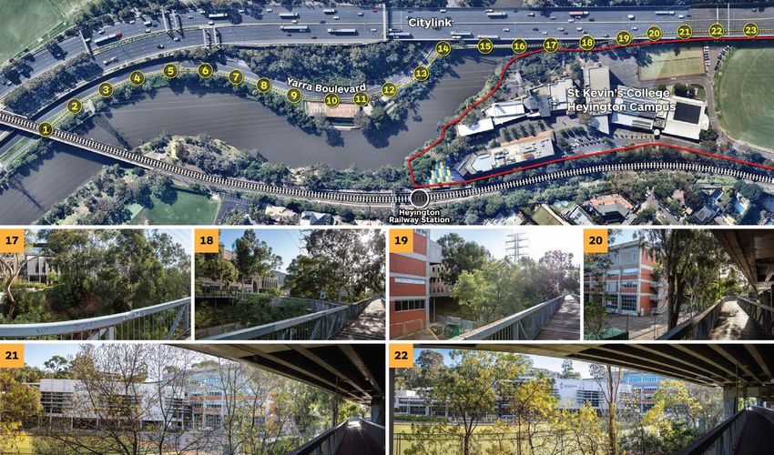
Table of contents:
Chapter / Section                                                                                                                              Page No.

1      Introduction                                                                                                                                    1
1.1    Preamble                                                                                                                                        1
1.2    Background and Instructions                                                                                                                     2
1.3    Summary of Conclusions                                                                                                                          2

2      Analysis                                                                                                                                        3
2.1    Does The Strategy Provide A Sound Framework To Guide Planning And Decision-Making?                                                              3
2.2    How Can The Strategy Be Interpreted To For Individual Sites Such As The St Kevin’s Campuses?                                                    4
2.3    What Further Work Is Required To Deliver Effective Planning Controls That Achieve The Vision For The River Corridor?                            11

3      Conclusion                                                                                                                                     14

       APPENDIX A - St Kevin’s College Sites - Photographic Study                                                                                     15

       APPENDIX B - Witness Statement                                                                                                                 22

ratio:consultants pty ltd
This work is copyright. Apart from any use as permitted under Copyright Act 1968, no part may be reproduced without written permission of ratio:consultants pty ltd.
Disclaimer: neither ratio:consultants pty ltd nor any member or employee of ratio:consultants pty ltd takes responsibility in anyway whatsoever to any person or
organisation (other than that for which this report is being prepared) in respect of the information set out in this report, including any errors or omissions therein.
ratio:consultants pty ltd is not liable for errors in plans, specifications, documentation or other advice not prepared or designed by ratio:consultants pty ltd.

                                                     Draft Yarra Strategic Plan: Part-2 Land Use Framework / Urban Design Expert Evidence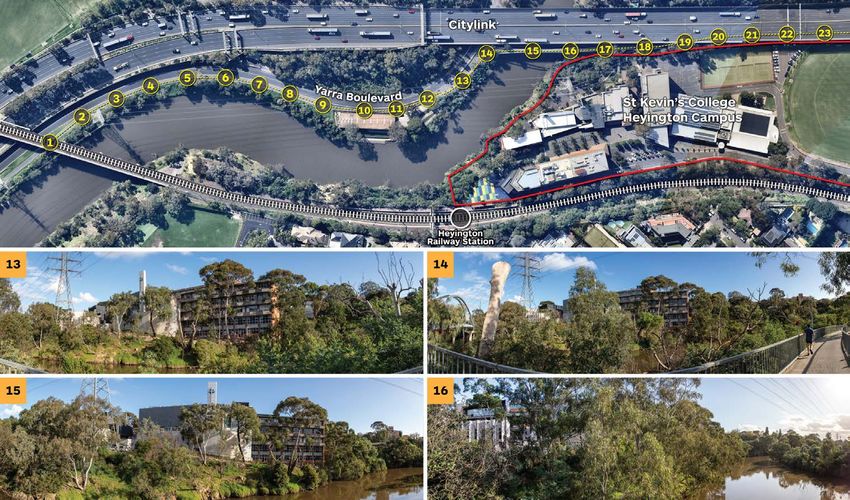
1. Introduction

      1.1 Preamble
001   The draft Yarra Strategic Plan …’sets out the community’s long-term
      aspirations for the Yarra River corridor.’ (P14 Draft Yarra Strategic Plan.)

002   It will be implemented over several decades through a combination of
      iterative decision making under the Planning and Environment Act, mainly by
      local authorities and then State management agencies responsible for the
      stewardship of parks and public open space adjacent to the river.

003   Managing an environmental resource like a river is complex especially when it
      runs through a major city like Melbourne.

004   If the strategy is to be effective in its long-term effect, there are some
      fundamental ingredients that are an imperative. Some of those ingredients are
      missing from this draft strategy and if not addressed will lead to its failure.

005   An effective strategy needs the following:
                                                                                                                               Figure 1 - Yarra River corridor in the future- Draft Yarra Strategic Plan P.57
      — A clear statement of its long-term intent (Where are we going?)
                                                                                                  008   The Yarra River deserves the same management success because as the
      — Evidence based data collection (What are the influences?)                                       Vision says ..’What is good for the Yarra is good for all’ p13
      — Distillation and synthesis of the data (What does it mean?)
                                                                                                  009   The problem with the strategy before the Panel is that it is high on aspiration,
      — Exploration of alternative management regimes (What are the                                     low on evidence-based data collection and interpretation. Low on distillation
        consequences of alternatives?)                                                                  that allows readers and land users to understand the logic and rationale to
                                                                                                        the management alternatives and the means of much of the implementation
      — What are the means of implementation (What is the best option for
                                                                                                        proposed particularly that affecting private land.
        managing the consequences?)
006   While this might sound like a lesson in Planning 101 it is a tried and true                 010   Before the document proceeds to approval my recommendation to the Panel
      formula that the best strategies employ.                                                          is that work needs to be done to address more cogently the 5 points I have
                                                                                                        made in the preamble.
007   In terms of environmental management, the Conservation Plan for the
      Southern Mornington Peninsula 1975 was effective in delivering long term                    011   This report highlights some of the key deficiencies, then sets out how the
      beneficial land management and stewardship of the Peninsula. It is still a place                  reviewed document might be approached. It uses the St Kevin’s school sites
      of great beauty and attraction because of the effectiveness of this policy                        adjacent to the Yarra in Toorak to illustrate some of the deficiencies in the
      initiative.                                                                                       Strategic work as a practical means of illustration.

                                                       Draft Yarra Strategic Plan: Part-2 Land Use Framework / Urban Design Expert Evidence                                                                1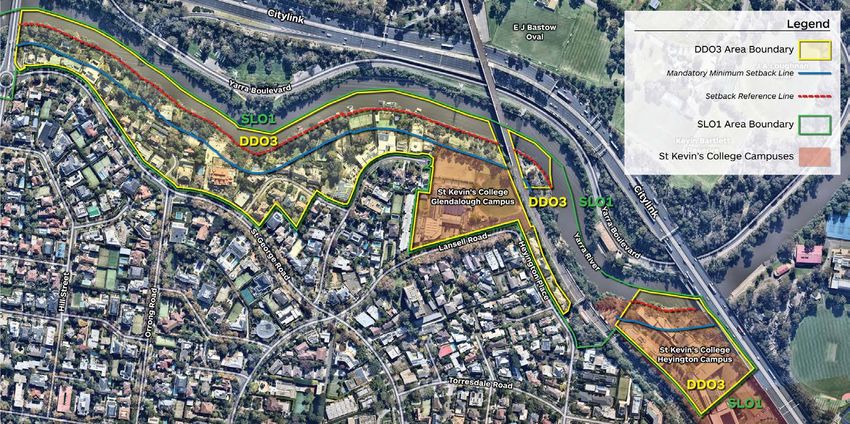
1.2 Background and Instructions                                                           019   The principal concerns raised in the St Kevin’s submission relate to the
                                                                                                      high level nature and broad geographical coverage of the Plan and its
012   Preparation of the draft Yarra Strategic Plan (the strategy) has been led by                    ability, therefore, to provide adequate policy guidance to inform planning
      Melbourne Water to provide a long-term vision for the Yarra River and to                        decisions across a range of local contexts and site conditions. It also raises
      support its future management.                                                                  concerns regarding the potential translation of the interim DDO3 control
                                                                                                      into a permanent control given the current control was introduced without
013   It covers the full length of the river from its upper reaches around Yarra                      consultation with landowners and has the effect of prohibiting development
      Glen through rural and suburban areas and Melbourne’s inner city as far as                      which, when topography and physical landscape are taken into account, would
      Docklands and the Port of Melbourne.                                                            have no effect on the Yarra River corridor.

014   The Strategic Plan comprises of two principal parts.                                      020   I have been requested by Norton Rose Fulbright lawyers on behalf of St
                                                                                                      Kevin’s College to review the Land Use Framework and provide my opinions
      — Part 1 sets out the vision for the Yarra, which is drawn from extensive                       regarding its potential efficacy in guiding future decision-making on land use
        community engagement. It also sets out a co-ordinated approach to                             and urban form matters and the development of permanent planning controls.
        investment that is intended to maximise value to the river and the
        community.
                                                                                                      1.3 Summary Of Conclusions
      — Part 2 is the land use framework which is intended “to provide a regional
        framework for land use planning and decision making on both public and                  021   In summary, my conclusion is that whilst the draft Yarra Strategic Plan
        freehold private land at a local level.” It provides directions at a whole-                   expresses laudable community aspirations for the long term management
        of-river scale as well as more localised directions within the four defined                   of the river corridor, the land use framework in Part 2 of the document is not
        ‘reaches’.                                                                                    sufficiently detailed or based in deep enough analysis to provide a useful
                                                                                                      framework to guide planning decisions, including decisions about future
015   Public consultation on the Strategic Plan took place in February and March
                                                                                                      planning controls such as zones or overlays.
      2020 and a number of submissions were made. The Panel has been
      established to consider submissions relating to Part 2 – Land Use Framework
      of the Plan.                                                                              022   My reasons for these conclusions are set out in the analysis section of this
                                                                                                      report, which follows.
016   St Kevin’s College has two campuses with frontage to the south side of the
      Yarra River in Toorak and is a submitter to the Panel.                                    023   Additional background information is included in the following appendices to
                                                                                                      this report:
017   Both St Kevin’s campuses are affected by the current interim planning controls
      within the Stonnington Planning Scheme (Design and Development Overlay                          — Appendix A - St Kevin’s College Sites - Photographic Study
      – Schedule 3 and Significant Landscape Overlay – Schedule 1) which seek to                      — Appendix B - Witness Statement
      protect the river corridor. These controls, along with similar controls in the
      planning schemes within the lower and middle segments of the river were
      introduced by the Minister for Planning in 2017 under Amendment GC48.

018   The draft strategy is intended to become a reference document in the
      planning scheme, to form the basis of new state and local planning policies
      for the river and envisages the introduction of permanent planning controls.
      However, it does not identify the process for introducing permanent controls
      or whether this will involve a fundamental review of the existing interim
      controls.

                                                     Draft Yarra Strategic Plan: Part-2 Land Use Framework / Urban Design Expert Evidence                                              2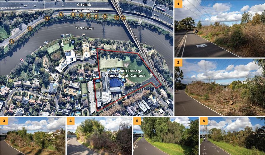
2. Analysis

      2.1 Does the strategy provide a sound framework to guide                                    033   For example, at Yarra Bend, Abbotsford, the uplift on which the Park is located
      planning and decision-making?                                                                     meets the basalt plains that extend into far Western Victoria. It is a confluence
                                                                                                        point and the reason why the Yarra loops in the way it does around Studley
024   While state and local agencies will deliver public works and policy initiatives                   Park. The vegetation associations are important here but we hardly know this
      that are outside the direct management of the Planning and Environment Act,                       from the Strategy, let alone what those associations are. It is available from
      that work will be largely delivered on public land. Much of the river corridor is                 other sources but not in this document. It is important to the Wurundjeri story
      in private and institutional ownership where many of those owning property                        just as it is to decision makers of land use permit applications on the opposite
      on the river edge place high value on it. They aspire to the same objectives as                   bank. It’s important to people teaching environmental science and its part of
      those expressed in the Draft Strategy. Their stewardship will be administered                     the charming ‘rawness’ of being in this Park just a few kilometres from the
      through the Planning and Environment Act.                                                         central city.

025   In this respect the purpose or intent of the strategy is clear.                             034   The juxtaposition of Park with a burgeoning end of the Victoria St Activity
                                                                                                        Centre means that new buildings are inevitable. How can this strategy be of
026   To meet the aspirations however, land users need to understand the rationale                      influence? And not just in terms of building height and set back?
      to management preferences.
                                                                                                  035   Knowledge of influences such as this are particularly germane to answering
027   Rivers tell stories.                                                                              the question …. what does it mean?

028   They are layered and they vary with the author. They depend on the prism                    036   The nature of the land system goes on to influence land use. Factories don’t
      through which the story is being told. But there are some influences that are                     get built on ‘uplifted’ mudstone it’s too steep. Ovals like flood plains and
      fundamental if environmentally based land use decisions are to be made in                         alluvial soils and houses like the aspect of bushland and can manage slope.
      the corridor.
                                                                                                  037   Given that the VPP planning framework provides for recognition of landscape,
029   The indigenous story is well recognized in this Plan. As it should be.                            vegetation and culturally significant places, this should be mapped and
                                                                                                        recorded in the Strategy in a way that planning controls can be made
030   But there are other stories to tell if the river is to be managed through                         influential in local authority decision making. While much of the river is now
      planning legislation as the narrative set out by the Wurundjeri seeks.                            covered with overlay controls recognizing ‘significance’ the basis or raison
                                                                                                        d’etre for the significance is not always clear. A good strategy forming part of
031   A key influence on the planning framework is the Geology and Geomorphology                        a planning scheme is a resource to those controls.
      of the river’s course. It is an indigenous story but for land use planning it’s
      another story.                                                                              038   What we often have, however, is a mix of acknowledgement of underlying
                                                                                                        environmental value and then a suggested action all in the one plan. There are
032   The Yarra rises on uplifted Mudstones and Sandstones that extend to East                          plans with legends, but their purpose is difficult to understand. They are like
      Gippsland. The shape of the riverbed, the width of the river and disposition of                   an inventory and an action plan all in one. This is not good analysis nor clear
      valleys and vegetation associations are tied to geology and soil. We have no                      distillation.
      idea how that plays out in this strategy. Land use is a response to geology.

                                                       Draft Yarra Strategic Plan: Part-2 Land Use Framework / Urban Design Expert Evidence                                             3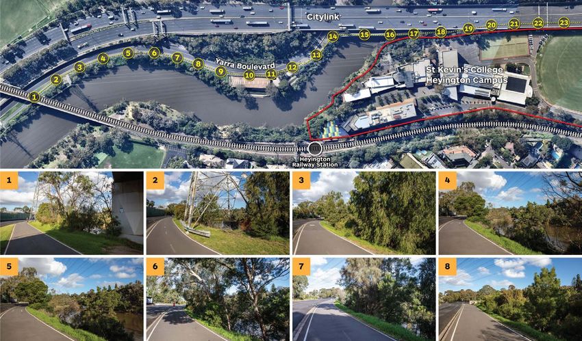
039   Again, for instance, at Page 111 the plan which does not have a title deals with            047   The Panel may be aware of the technique known as sieve mapping where the
      Yarra Bend. There is an inventory of Key views, Wurundjeri protection areas                       layered influences of an area are placed over one another to ascertain the
      and significant sites and billabongs and then notations calling for improved                      value and then risk to health of the system that the mapping reveals. In many
      access. This confuses the message between what is the underlying value and                        respects it is a method of analysis and distillation that should be applied to
      then what should be done about it in an ordered series of actions. Providing                      underpin the intent of this strategy more effectively.
      improved access is not the only aspiration that should be met to achieve the
      strategic intent for a healthy river.                                                       048   As a test of the usefulness of the strategy to private or institutional
                                                                                                        landowners, it is instructive to look at the influence it has on the two riverfront
040   The points 2, 3 and 4 set out in my Preamble are:                                                 campuses of St Kevin’s College at Toorak.

      — Evidence based data collection (What are the influences?)
                                                                                                        2.2 How can the strategy be interpreted for individual sites such as
      — Distillation and synthesis of the data (What does it mean?)                                     the St Kevins campuses?
      — Exploration of alternative management regimes (What are the consequences
                                                                                                        How do the existing planning controls work?
        of alternatives?)
                                                                                                  049   St Kevin’s College has two campuses with frontage to the river corridor in
041   In my assessment, these are insufficiently resolved in the strategy for them
                                                                                                        Toorak, namely:
      to lead to a coherent planning framework that uses the full suite of provisions
      available in the VPP system. More critically it does not explain why some things
                                                                                                        — The Heyington Campus at 31 Moonga Road (senior students); and
      are important and others less so and what might be done about it in making
      land use decisions.                                                                               — The Glendalough Campus at 75 Lansell Road (junior students).
                                                                                                  050   A summary of the existing planning controls affecting the two sites is set out
042   What is the nature of the remnant vegetation? How important is it to the river
                                                                                                        in the table below:
      story? What options are there available to manage it?

043   We have no idea from the strategy the extent, nature, and quality of vegetation                   Heyington Campus                           Glendalough Campus
      along the river corridor and yet its presence in this situation is critical to the
      ongoing health of the river the strategy so enthusiastically aspires to achieve.                  Special Use Zone schedule 1                General Residential Zone Schedule 8

044   The nature and influence of landscape is significant in most places along the
                                                                                                        Land Subject to Inundation Overlay         Land Subject to Inundation Overlay
      river and while earlier documents have partly addressed this it is effectively
      absent or very difficult to find and interpret from this document.
                                                                                                        Incorporated Plan Overlay Schedule 1       Incorporated Plan Overlay Schedule 1
045   Landscape significance and character gets picked up in the existing Significant
      Landscape Overlays (SLO’s) covering parts of the river but there is a generic                     Significant Landscape Overlay schedule 1   Significant Landscape Overlay schedule 1
      basis to much of how those controls are to be given effect in decision making                     – interim (expiring 31 January 2021)       – interim (expiring 31 January 2021)
      by local authorities.
                                                                                                        Design and Development Overlay             Design and development Overlay
046   If the strategy is to have the influence over time, that the proponents aspire                    Schedule 3 (Area A) – interim              Schedule 3 (Area A) – interim
      to, this sort of information and interpretation is critical in the ongoing decision               (expiring 31 January 2021)                 (expiring 31 January 2021)
      making about land use that will be made mainly by municipal planners with
      probably limited understanding of the environmental consequences of                               Citylink Project Overlay
      managing a river.                                                                                                                                Table 1 - A summary of the existing controls

                                                       Draft Yarra Strategic Plan: Part-2 Land Use Framework / Urban Design Expert Evidence                                                      4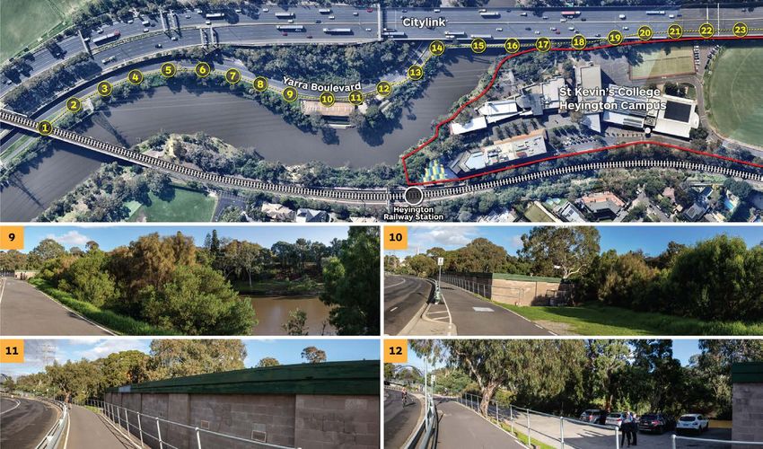
051   The interim SLO1 and DDO3 controls that protect the river corridor affect both                — A set of landscape character objectives to be achieved;
      sites in the manner shown at Figure 2.
                                                                                                    — Application requirements including shadow diagrams demonstrating
                                                                                                      effects on the Yarra River and open space, and visual impact assessment of
052   SLO1 acts as a permit trigger for buildings and works and vegetation removal.
                                                                                                      proposed development from public viewing points and the Yarra River; and
      It includes;
                                                                                                    — Decision guidelines in relation to landscape, environmental and cultural
053   A statement of the nature and key elements of the landscape;                                    values; protection of waterway and the riprarian zone; public open space
                                                                                                      and access; and siting and design of built form.

                                                                                                                                                    Figure 2 - The interim SLO1 and DDO3

                                                    Draft Yarra Strategic Plan: Part-2 Land Use Framework / Urban Design Expert Evidence                                              5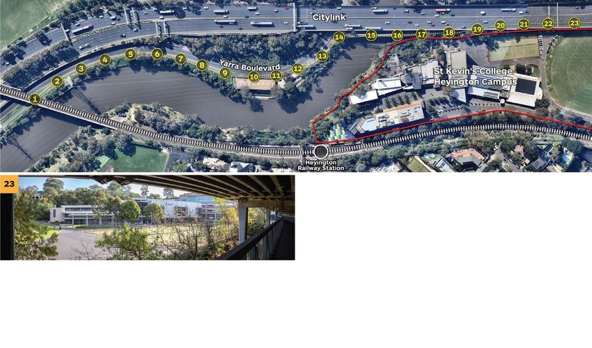
054   This control is useful to the extent that it requires a qualitative assessment of           063   Whilst these quantitative tests may represent reasonable parameters
      impacts on the river landscape.                                                                   for managing residential development on conventional lots in some
                                                                                                        circumstances, the requirements do not appear to have considered the variety
055   However, it is, by definition, quite generic in that it covers a relatively lengthy               of conditions present along the river or the effects on extensive institutional
      stretch of the river. Whilst it provides some description of the existing range                   campuses such the St Kevin’s sites.
      of landscape character conditions that exist along this part of the Yarra, it
      does not provide guidance as to how what is valued is to be protected, or how
                                                                                                        In relation to the Heyington Campus:
      areas of eroded landscape quality are to be enhanced.
                                                                                                        — The campus occupies a narrow and deep parcel of land defined by the
056   Such guidance need not sit within a statutory overlay control in the planning                       raised Citylink freeway above the Gardiners Creek to the east and the Glen
      scheme but should be available within an underpinning strategy document.                            Waverley line railway corridor to the west.

057   The absence of more detailed analysis and guidance from the draft strategy                        — The campus rises steeply at the rivers edge with buildings built into and
      will make interpreting the intent of this interim control (or a future permanent                    stepping up the rocky vegetated escarpment. Buildings are clustered
      SLO control) difficult for landowners and decision-makers considering                               towards the north of the site and ground levels drop down again to the
      individual sites.                                                                                   south where the school’s sporting facilities sit at a lower level within the
                                                                                                          floodplain.
058   The interim DDO3 control similarly acts as a permit trigger for buildings and                     — The DDO3 30m setback line runs through the middle of existing school
      works. It contains a series of design objectives covering landscape protection;                     buildings fronting the river and prevents even minor changes or additions
      siting and design; and site coverage and permeability.                                              to these buildings which could be designed to ensure they have no adverse
                                                                                                          effects on views from and across the river corridor.
059   Unlike SLO1 in addition to qualitative requirements, it includes mandatory
      requirements relating to the river setbacks, building height and shadowing of                     — The 9/10m height restriction extends over much of the built area of the
      the river.                                                                                          Heyington Campus and includes areas where, taking into account the site
                                                                                                          topography and intervening built form, buildings of more than 9m could
060   The Heyington and Glendalough campuses are within Area A for which the                              comfortably be accommodated without any visual impact on the river
      following mandatory requirements apply:                                                             corridor or views from public vantage points on the opposite bank.

      — Minimum building setback from the river of 30m (from the setback
        reference line);
      — A maximum building height of 9m (or 10m on sloping land); and
      — No additional shadow on the river (beyond the setback reference line)
        between 11:00am and 2:00pm on 22 June.
061   Complete or partial replacement of an existing building within the 30m
      setback area is limited to 9m and cannot reduce the existing setback from the
      river or increase the floorspace of the building.

062   These requirements apply to the whole of Area A irrespective of existing
      vegetation, topography, built form conditions, ownership or land use.

                                                                                                                                                  Figure 3 - St Kevin’s College - Heyington Campus

                                                       Draft Yarra Strategic Plan: Part-2 Land Use Framework / Urban Design Expert Evidence                                                     6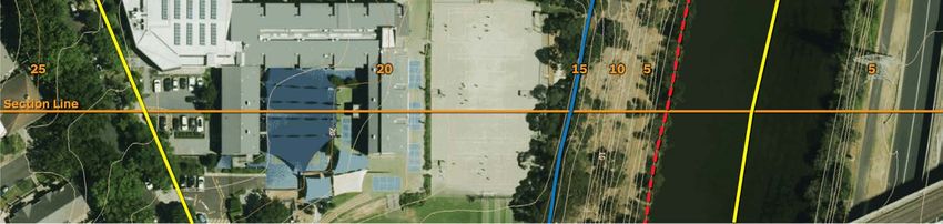
Figure 4 - Sightline diagram locations                                                                           Figure 5 - Sightline Diagram 1

Yarra Boulevard

                                                                                                                                   Figure 6 - Sightline Diagram 2

                                            Draft Yarra Strategic Plan: Part-2 Land Use Framework / Urban Design Expert Evidence                               7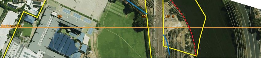
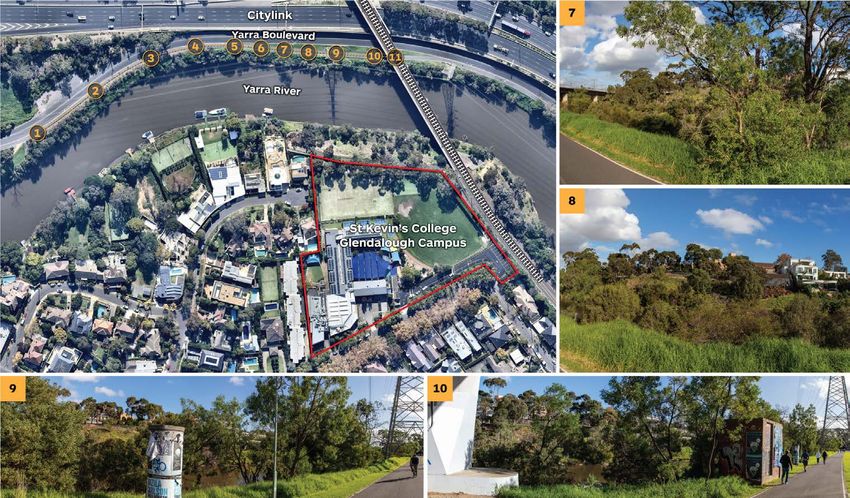
For Glendelough:                                                                                What effect will the draft strategy have?

— This campus sits on a landform where the steeply sloping vegetated                            The proposed Land Use framework within the strategy foreshadows the
  riverbank rises to a relatively level plateau approximately xxm above the                     introduction of permanent planning controls for the river corridor to replace
  river. Buildings are set back from the plateau edge towards Lansell Road                      the current interim controls. However, there is little clarity in regard to the
  and have little visual prominence when viewed from Yarra Boulevard on the                     process for preparing and implementing permanent controls.
  opposite side of the river.
— The 9/10m height limit affects the whole of this campus and extends                           It seems that there are two ways in which this could be undertaken.
  southward to Lansell Road, between 140m and 200m from the river’s edge,
  preventing any development above this height even in locations where                          Either:
  taller built form would have no impact on river views.
                                                                                                — The existing interim controls are made permanent in their existing (or a
                                                                                                  slightly modified) form. This would leave substantial deficiencies in the way
The indicative sightline diagrams at Figure 6 to Figure 7 provide an illustration
                                                                                                  development is managed on sites such as St Kevin’s. The strategy would
of the way in which the mandatory building heights limit the potential to
                                                                                                  become a reference document in the planning scheme but, even if it is
consider taller built form in areas well removed from river views. This limits
                                                                                                  strengthened to include additional analysis and guidance to provide a more
the ability of the school to plan effectively for its future needs without any
                                                                                                  useful framework for consideration of planning proposals, the mandatory
demonstrable benefit to the management of the river environment.
                                                                                                  DDO requirements would prevent their interpretation in a nuanced way on
                                                                                                  individual sites.
A photographic study of views to the two campuses from the river corridor is
at Appendix A. This study illustrates the journey along the opposite bank of                    Alternatively:
the river, the availability of views towards the two campuses, and the way in
which factors such as curves in the river alignment, topography, vegetation                     — New planning controls are prepared based on more detailed and ‘finer
and infrastructure such as bridges affect the availability of public views. This                  grain’ analysis undertaken in the manner described in the following section
complex interplay is not adequately reflected or addressed in the existing                        of my evidence. This analysis should be included in the strategy and
DDO control, with its standardised building setback and heights which obviate                     reflected in associated policy within the planning scheme so that there
the use of discretion and contextual assessment in favour of mandatory                            is a clear flow through the strategy to planning scheme policies and the
numerical requirements. .                                                                         resultant statutory controls.

                                                                                                Clearly, the second approach is a better way to ensure effective planning for
The sightline examples illustrate the issues and foregone development
                                                                                                land along the river.
potential that can arise from the application of generic controls in a blanket
manner without detailed analysis of land capability, development constraints
and opportunities, environmental factors and the like.                                          However, the strategy in its current form is not capable of being effectively
                                                                                                interpreted for individual sites and therefore will have only a peripheral effect
                                                                                                on planning decision making even if reflected in state and local policies. It is
Whilst the background reports that informed the preparation of AM GC48,
                                                                                                simply too general and too high level.
such as the Lower Yarra Recommendations Report, identified some of the
nuance and complexity involved in managing a diverse and varied river
corridor, this was not reflected in the interim controls. The draft Strategy does
not provide clarity as to how this shortcoming is to be addressed.

                                                Draft Yarra Strategic Plan: Part-2 Land Use Framework / Urban Design Expert Evidence                                                8
Figure 7 - Sightline Diagram 3 Draft Yarra Strategic Plan: Part-2 Land Use Framework / Urban Design Expert Evidence 9
Figure 8 - Sightline Diagram 4

Draft Yarra Strategic Plan: Part-2 Land Use Framework / Urban Design Expert Evidence                              10
2.3 What further work is required to deliver effective planning                             073   For example, if one were advising St Kevin’s it would be useful to know if the
      controls that achieve the vision for the river corridor?                                          remnant vegetation is valuable, does it serve a habitat function for fauna and
                                                                                                        bird life? Would a landscape master plan be beneficial for the whole campus
064   As the Panel will be aware managing the health of a river in any circumstance                     and what should its function be beyond its aesthetic role?
      is difficult. There are tensions in this at every level of government and in every
      land user adjacent and within the catchment. This is especially so in a dry                 074   These matters are in part addressed in the Lower and Middle Yarra studies of
      continent like Australia.                                                                         2016 but need to be extended and interpreted in this current document.

065   Invariably that task becomes fragmented into a multiplicity of hands and the                075   A second volume to the strategy could become a key resource to decision
      Yarra River is no exception to this circumstance.                                                 makers dealing with applications for land use and development. Its contents
                                                                                                        would usefully include addressing the following matters.
066   Developing a strategy that hits at the core objective which is to achieve
      a healthy river system is one of the most challenging tasks facing the                            Land System Mapping
      environmental manager.
                                                                                                        — Map the primary geological formations and influences along the course of
                                                                                                          the river and identify sites and locations of significance.
067   The Yarra has seen a number of strategies developed over that past 50 years.
      All well intentioned and, contributing to improvements to the quality of the                      — Use this information to define and map land systems. This is partly done
      river and its environs.                                                                             through character types in the 2016 study and studies by CSIRO and others
                                                                                                          have developed them, but they need to be defined not just by existing land
068   What regrettably happens in these circumstances, however, is that knowledge                         use and character but by their inherent geomorphological foundation. This
      gets lost.                                                                                          is a key influence to the river story, whether it be the Wurundjeri story, the
                                                                                                          geologist’s story, or planner’s story.
069   If this strategy is to be a seminal influence in achieving the aspirations it
                                                                                                        Commentary
      seeks to achieve it needs more work that includes revisiting ‘lost’ knowledge.
      This knowledge needs to be distilled and interpreted into a form that                       076   Understanding how the geomorphology of the river works will inform the
      allows it to be used constructively within the framework of the VPP when its                      nature of land use controls over the height and set back of new buildings and
      administration lies largely with local government.                                                structures along the course of the river.

070   I commented earlier that much of the land adjacent to the river is in private               077   Basic physical geography tells us that rivers rise in the mountains. They
      ownership and so decisions to improve the health of the river in this                             start as a trickle moving more quickly and with greater velocity on the steep
      circumstance will be largely made through permit applications.                                    descent to the plains below. In this high country their erosive qualities are high
                                                                                                        and they are usually very clean.
071   Each decision can be another small step in meeting the aspirations of the
      strategy or another loss in the process of ‘death by a thousand cuts’ to the                078   As they run to the plain, the movement of water slows, river banks break when
      health of the river.                                                                              in flood creating flood plains rich in alluvial soil, turbidity can increase, and
                                                                                                        deposition of suspended soils creates deltas, oxbows (billabongs) fragmenting
072   When an application to extend a school campus is made to a local authority, a                     the original shape of river flow.
      river strategy should be a valuable resource document to the interpretation of
      decision guidelines and design objectives. That is not the case here.                       079   Understanding how the river works in this way should Inform decisions around
                                                                                                        fundamental matters like building set back and height controls.

                                                       Draft Yarra Strategic Plan: Part-2 Land Use Framework / Urban Design Expert Evidence                                            11
080 In my assessment it is the reason why the interim controls introduced for the 087 The indigenous vegetation along a river, if healthy, provides a faunal corridor.
river edge are generic in their conception. Basically, the setback remains the It expands populations of native bird and mammal life if it is connected in long
same along the course of the river irrespective of the shape of the river and lengths of sufficient depth. Properly fenced It can resist the attacks of feral
its banks. It does not represent a measured and clear understanding of the animals that decimate native wildlife.
shape and nature of the geomorphology of the river and its consequent effect
on land use. 088 If the aspiration in this strategy is to be met over time, this 2020 piece of work
is critical to ensuring iterative decision making, step by step, implements the
081 There is a ‘disconnect’ between the ‘science’ of the strategic investigation vision.
required here and the rationale and logic to the interim controls.
089 The vegetation assessment is a key plank in that success.
Vegetation
Tributaries
— Map vegetation by EVC association, extent and quality in the catchment
area defined in the brief to Melbourne Water. — Identify all local steam lines and tributaries entering the Yarra
— Establish where it is owned privately and publicly. — Describe their health on a comparative scale and their contribution to river
health.
— Identify why it is important to river health.
Commentary
Commentary
090 A primary source of river pollution is from storm water. To a large extent
082 Apart from water flowing in the river the type, nature and health of indigenous
storm water drains enter the river along the course of small streamlines and
vegetation along its course is the single most important contributor to the
tributaries that run into the river system.
health of the river.
091 Managing the health of storm water is again complex and difficult. But
083 There is no ‘science based’ Investigation of this natural system influence in the
knowing where these concentration points are along the course of the river
strategy. The 2016 background report calls for a study of this nature. However,
is important to local government planners in making decisions that can
if this has been done there is no evidence of it in this 2020 document.
contribute to the mitigation of polluted water entering the river system.
084 If it has not been done, it should be, because this would be a very useful and
092 There is no recording of the location and effect of these natural system
persuasive element in the future beneficial management of the river and is
influences and their contribution to the erosion of water quality in the
currently missing.
strategy. Again, a local government planner is left uninformed about this issue.
085 While the plans in the Strategy sometimes point to places where new planting
Cultural Influences
is encouraged, there is no supporting material that tells us what nature,
function and type of planting is encouraged. 093 The strategy does identify the location of important indigenous cultural sites
along the river and these can be translated into the VPP system.
086 Indigenous vegetation along the course of the river has been severely
interfered with over time. There is a strong case to reverse that situation. But 094 There are other culturally important elements including sites of botanical and
how does a local government planner know what to encourage, where and to geological significance which are not identified. These again are integral to
what extent, when he or she participates in a preapplication consultation or any sound strategic investigation and intent.
assesses a proposal for further development whether it be a school campus
or an individual home owner?
Draft Yarra Strategic Plan: Part-2 Land Use Framework / Urban Design Expert Evidence 12Summary
095 One of the reasons for the success of the Conservation Plan 1975 on the
Mornington Peninsula was that its supporting investigative research was
based in science. The subsequent planning framework was controversial
because it was different, but in the long term it was effective in delivering
‘conservation’ of the valued assets of the Peninsula.
096 This included its indigenous vegetation, its valued rural and coastal
landscapes and its creeks and streamlines.
097 They were protected by policy grounded in science-based Investigation.
098 The problem with this strategy for the Yarra River is that it lacks science
based investigation. It is seemingly high on consultation with some, but low on
delivering research and advice that planners can use to interpret beneficially
into new controls and day by day decisions on permit applications.
099 It is the reason why the interim controls are largely generic and in this respect
it will not serve the fundamental purpose of a soundly based strategy that
will be the back bone to delivering on the intent set out in its aspirations for a
healthy river. There is still too much of the puzzle missing for it to be coherent
in its role as a strategy.
Draft Yarra Strategic Plan: Part-2 Land Use Framework / Urban Design Expert Evidence 133. Conclusion
100 In summary, my conclusion is that whilst the draft Yarra Strategic Plan
expresses laudable community aspirations for the long term management
of the river corridor, the Land Use Framework in Part 2 of the document is
not sufficiently detailed or based in deep enough analysis to provide a useful
framework to guide planning decisions, including decisions about future
planning controls such as zones or overlays.
101 If the role of the strategy is to provide a useful and long-lasting framework for
development decisions on private land, further work is required as described
in Section 2.3 of this report.
T W Biles
Draft Yarra Strategic Plan: Part-2 Land Use Framework / Urban Design Expert Evidence 14APPENDIX A - St Kevin’s College Sites - Photographic Study
Figure A1 - Glendalough Campus Photographic Assessment 1
Draft Yarra Strategic Plan: Part-2 Land Use Framework / Urban Design Expert Evidence 15APPENDIX A - St Kevin’s College Sites - Photographic Study
9
Figure A2 - Glendalough Campus Photographic Assessment 2
Draft Yarra Strategic Plan: Part-2 Land Use Framework / Urban Design Expert Evidence 16APPENDIX A - St Kevin’s College Sites - Photographic Study
1 2 3 4
5 6 7 8
Figure A3 - Heyington Campus Photographic Assessment 1
Draft Yarra Strategic Plan: Part-2 Land Use Framework / Urban Design Expert Evidence 17APPENDIX A - St Kevin’s College Sites - Photographic Study
9 10
11 12
Figure A4 - Heyington Campus Photographic Assessment 2
Draft Yarra Strategic Plan: Part-2 Land Use Framework / Urban Design Expert Evidence 18APPENDIX A - St Kevin’s College Sites - Photographic Study
13 14
15 16
Figure A5 - Heyington Campus Photographic Assessment 3
Draft Yarra Strategic Plan: Part-2 Land Use Framework / Urban Design Expert Evidence 19APPENDIX A - St Kevin’s College Sites - Photographic Study
17 18 19 20
21 22
Figure A6 - Heyington Campus Photographic Assessment 4
Draft Yarra Strategic Plan: Part-2 Land Use Framework / Urban Design Expert Evidence 20APPENDIX A - St Kevin’s College Sites - Photographic Study
23
Figure A7 - Heyington Campus Photographic Assessment 5
Draft Yarra Strategic Plan: Part-2 Land Use Framework / Urban Design Expert Evidence 21APPENDIX B - Witness Statement
Name and Address Investigations and research
Tim Biles In preparing this evidence I have:
Ratio Consultants Australia Pty Ltd — Reviewed the draft Yarra Strategic Plan and background documents.
8 Gwynne Street, Cremorne 3121 — Reviewed the relevant policies and provisions in the Stonnington Planning
Scheme that affect the St Kevins College Heyington and and Glendalough
Qualifications campuses.
— Bachelor of Arts, Flinders University 1969
— Reviewed the planning policy framework and the relevant planning controls
— Diploma of Town Planning and Regional Planning, Melbourne University for the subject site.
1975
— Fellow, Planning Institute of Australia Summary of opinions
My conclusions are summarised in the preamble and conclusion of this report.
Areas of expertise
I have practised in the field of town planning since 1970 and qualified in 1975. Declaration
My experience includes working in strategic and statutory planning for local In accordance with the Tribunal’s Practice Note No. 2, I declare that I have
government authorities and private consulting dealing with a variety of resi- made all the inquiries that I believe are desirable and appropriate and that no
dential, commercial, industrial and conservation issues. matters of significance which I regard as relevant have to my knowledge been
withheld from the Tribunal.
I give planning and urban design advice to a wide range of commercial and
local government clients involved in the preparation of a range of commercial I prepared this report with assistance from Mathew Furness, Senior Associate
and residential projects. and Gokhan Karpat, Associate Urban Designer at Ratio Consultants Australia
Pty Ltd.
I have also led a series of townscape plan studies as well as landscape and
urban design programs across country Victoria and Melbourne.
Expertise to prepare this report
As a qualified town planner with over 40 years in practice I have had to assess
and provide strategic and land use planning advice on a wide range of town T W Biles
planning and urban design issues. BA DipTRP FPIA
Draft Yarra Strategic Plan: Part-2 Land Use Framework / Urban Design Expert Evidence 22You can also read