Report of the A14 Joint Working Steering Group
←
→
Page content transcription
If your browser does not render page correctly, please read the page content below
Report of the A14 Joint Working Steering
                       Group

This report summarises work undertaken on behalf of a multi-agency Steering Group in relation to the
A14. It was submitted to the Transport Minister in January 2007. The Minister has asked the
Highways Agency to validate this work, and to work up proposals for fuller evaluation. Should the
Minister then decide, proposals will begin a statutory process including public consultation. The plan
shown at Figure A.1 is purely illustrative and was prepared for the purpose of transport modelling. It
does not represent a proposal.
Please ask for   : Brian Wooding

ab
                                                           Tel              : 01604 654315
                                                           Our Ref          :-
                                                           Your Ref         :-
                                                           Date             : 17 January 2007

Mike Goodwin
Department for Transport
3/15 Gt. Minster House
76 Marsham Street
London
SW1P 4DR

A14 JOINT WORKING STEERING GROUP

ASSESSMENT OF THE MITIGATION MEASURES IN SUPPORT OF THE NORTH
NORTHAMPTONSHIRE CORE SPATIAL STRATEGY

SUMMARY OF MAIN POINTS

1. North Northamptonshire is a key part of the MKSM Growth Area with a target of an
   additional 52,100 homes and 43,800 jobs by 2021. The step change in housing
   delivery is being realised with completions up more than 50% since 2001/02.

2. Predicted traffic increases from future planned growth is now threatening the delivery of
   that growth because of the inadequacies of the local and national road network

3. A major cause of these concerns is the level of local traffic using the A14 corridor
   particularly around Kettering

4. Without agreement on a package of improvements and measures including investment
   in the A14, growth targets will not be achieved.

5. The Joint Working Steering Group on the A14 has reached broad agreement on a
   practical way forward for consideration by the relevant agencies, with the aim of
   including the preferred option in the North Northamptonshire Core Spatial Strategy and
   relevant programmes.

6. The preferred option can accommodate the growth proposals in the emerging Core
   Spatial Strategy to 2021. It also provides additional capacity to accommodate further
   growth post 2021.

  Transport Planning and Growth
  Sustainable Transport
  Riverside House, Riverside Way, Bedford Road
  Northampton, NN1 5NX
  w. www.northamptonshire.gov.uk
  t. 01604 654315
  f. 01604 654455
  e. bwooding@northamptonshire.gov.uk
                                                                      a
7. The total cost of implementing the preferred scheme, which includes modal shift,
Transport Strategy for Kettering (TSfG), and a reduced A14 improvement, is some
£242.68m.
Growth Implications of the Preferred Option - summary
When NCC HA Developer Growth
released
2006/07- TSfK and Modal Identification of Travel Plans 26,700
2015/16 Shift Strategy schemes and and other homes and a
(£33.5m based on preliminary work measures similar
TSfK being number of
delivered over ten jobs
years)
2016/17- Modal Shift Collector Travel Plans 17,300
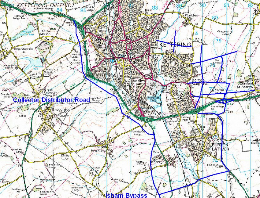
2020/21 Strategy Distributor Road and other homes and a
between junctions measures similar
7 and 9 - 2016 number of
(£109.44m) jobs
Improvements
junction 9-10/10A
- 2019 (£75.77m)REPORT OF THE A14 JOINT WORKING STEERING GROUP Purpose of the Report The purpose of this report is to illustrate a practical and deliverable solution for enabling housing and economic growth in North Northamptonshire by managing the impact of predicted traffic on the operation of the A14 and on the local road network over a wider area Planning and Growth Context The Government’s Sustainable Communities Plan (February 2003) identified the Milton Keynes South Midlands (MKSM) area as one of four growth areas for the greater southeast. Following this, a Sub-Regional Strategy for the area (which covers Northamptonshire, Milton Keynes, Aylesbury Vale, and Bedfordshire) was prepared. It has since been incorporated within the Regional Spatial Strategy for the East Midlands (March 2005) and referred to here as the ‘RSS’. The RSS sets out a long-term spatial Vision for the sub-region towards the year 2031, with specific guidance to 2021. It also sets out guidance on the scale, location and timing of development and the associated transport, employment and the social infrastructure, as well as the delivery mechanisms needed to achieve the Government’s vision for sustainable communities. North Northamptonshire is a key component of the growth area. The RSS outlines that it should accommodate 52,100 new dwellings between 2001 and 2021, with 34,100 of these provided within the neighbouring growth towns of Corby, Kettering, and Wellingborough. This growth would increase the population of North Northamptonshire by 85,000 (from 285,100 in 2001 to 370,100 in 2021). The RSS sets the goal of achieving 43,800 new jobs over the same period. The step change in housing delivery is being realised with completions up more than 50% since 2001/02. Currently North Northants is providing 25% of the MKSM housing growth requirement. More detailed proposals for accommodating this growth will be coming forward in the Core Spatial Strategy (CSS) for North Northamptonshire. This reinforces the spatial guidance in the RSS and proposes that development will be principally directed towards the north- south urban core, focused on the three Growth Towns of Corby, Kettering, and Wellingborough. It proposes that the smaller towns of Burton Latimer, Desborough, Higham Ferrers, Irthlingborough, Rothwell, and Rushden will provide secondary focal points for growth within this urban core.
Figure 1 North Northants Growth Towns

The Northamptonshire Transport Strategy for Growth (TSfG)

The County Council commissioned work on the TSfG to meet the aspirations of the RSS
and is currently being consulted on. To date the TSfG has provided an agreed framework
to assess transport projects against national, regional and local economic, housing, social
and environmental objectives, and therefore to extract sub-regional priority schemes.
The County Council is now developing an evidence-based Integrated Transport Strategy
  to complement the housing growth that will stimulate regeneration and economic growth
  necessary to ensure a sustainable future for Northamptonshire.

  Its purpose is to avoid potential threats to the transport system resulting from growth by
  optimising investment interventions in transport infrastructure. In recognition of the
  differing transportation requirements for each of the growth towns, the TSfG will provide
  specific town transport strategies. These strategies are currently in draft and are the
  subject of consultation.

  The ‘A14 issue’

  The A14 is crucial to North Northamptonshire both in terms of facilitating internal
  connectivity and in terms of linkages to other destinations and markets. It performs a
  strategic role as part of the Trans-European Transport Network linking the M6, M1, and A1
  corridors providing a strategic route from Ireland and the North West through to Felixstowe
  and the other Haven Ports and onto mainland Europe. As such, the route carries a high
  proportion of HGV traffic and is a significant economic route.

  The A14 between the M6 and A1 is also part of the strategic road network subject to the
  Public Service Agreement Reliability Target agreed between the Highways Agency and
  the Government.

  Looking more locally, the Kettering ‘Bypass’ is one of the most congested sections of the
  A14 with a number of closely-spaced grade separated junctions with other major road
  corridors (A43, A509, A6), some of which ‘share’ parts of the existing bypass. Similar to
  other parts of the strategic road network, much of the congestion problem around Kettering
  is caused by local traffic hopping on and off the A14.

                                                                                         Figure 2
                                                   Predicted percentage increase in traffic in North Northamptonshire
                                                           - including proposed modal shift targets (am peak)
                                          210

                                          200

                                                                                                              Total predicted trips (no
                                                                                                              modal shift)
%Increase in trips fromBase year (2005)

                                          190

                                          180                                                                 5% reduction in existing
                                                                                                              traffic (Town centre
                                          170
                                                                                                              modal shift)
                                                                                                              20% reduction in
                                                                                                              development traffic
                                          160
                                                                                                              (modal shift target)
                                                                                                              Optimised Modal Shift
                                          150
                                                                                                              (town + development
                                                                                                              modal shift targets)
                                          140

                                          130
                                            2011                2016              2021               2031
                                                                         Year
These capacity issues affecting both the local and national road network, in particular the
A14 as it circumnavigates Kettering, are a major constraint on the levels of growth that can
be accommodated in North Northamptonshire. Therefore, a solution is required that
allows the housing and economic growth to take place within the constraints of the local
road network and what can reasonably be expected in terms of further investment in it.
The County Council, in its draft Modal Shift strategy, has set itself a stretching target.
Nevertheless, even if this target is reached, the sheer numbers of additional trips mean
that considerable additional investment is required as illustrated in Figure 2.
Highways Agency - A14 Kettering Bypass Widening Study
In his July 2003 response to the recommendations of the London to South Midlands Multi-
Modal Study, the then Secretary of State for Transport instructed the Highways Agency to
undertake further work on the Kettering Bypass section of the A14 route.
An options study was commissioned and several improvement alternatives, including one
suggested by local stakeholders, have been assessed. The study work has taken into
account the housing and employment growth outlined in the RSS.
Options Examined
The options study undertaken by Scott Wilson for the Highways Agency looked at three
specific types of road capacity improvements in an effort to find a solution to the
congestion problems on the A14 in the greater Kettering area. These improvements can
be summarised in general terms as follows:
1) On-line widening of the existing A14 from just west of Junction 3 to east of Junction
10 from its existing cross-section of Dual 2 Lane All-Purpose to Dual 3 Lane All-
Purpose, with no change to the existing junction locations. The widened facility
would cater for both strategic and local traffic.
2) Off-line bypasses of the sections of the existing A14 worst affected by current
problems. Three specific options were looked into, namely:
i) a route close to, and south of, the existing A14, which includes a section of
on-line widening through the restricted Burton Latimer area;
ii) a route located a significant distance to the south of the existing dual
carriageway; and
iii) a route passing to the north of Kettering.
These options are solely for strategic traffic, with no junctions along their lengths –
local traffic having to join or leave the trunk road network at the extremities of the
new schemes.
3) Local ‘distributor road’ options – which include provision of new carriageways just
south of the existing A14 for the local traffic. These would be combined with the
closure of various slip roads between Junctions 3 and 9 to discourage local traffic
accessing, and junction hopping along, the existing A14.
As a result of the study work, including economic assessment, the Highways Agency
concluded that the provision of new road capacity for the benefit of strategic traffic did not,in terms of value for money (Benefit Cost Ratio), represent a viable solution to the A14
congestion problem in the Kettering area. Cost estimates ranged from £300m to £470m
(2005 prices).
A14 Joint Working Steering Group
In 2006 the A14 Joint Working Steering Group (JWSG) formed. This group is chaired by
North Northamptonshire Development Company (NNDC) and includes representatives of
NNDC, Northamptonshire County Council, North Northamptonshire Joint Planning Unit,
East Midlands Development Agency, Department for Transport, Highways Agency,
Department for Communities & Local Government, and Government Office for the East
Midlands.
Its brief was to develop and agree a package of interventions as a practical way forward to
deliver the planned housing and economic growth across North Northamptonshire, and to
produce a delivery plan by the end of December 2006. It was recognised that good and
effective partnership working amongst the various agencies and stakeholders involved
would be essential for success.
The JWSG recognised that providing capacity on the highway to accommodate the totality
of growth was neither desirable nor feasible, and that modal shift would have to be a vital
part of the package.
A summary of the technical work on the consideration of options is attached in Annex A
A14 Joint Working Steering Group Preferred Option
At the meeting of the A14 JWSG held on 15 December, partners reached ‘broad
agreement’ on the ‘proposition’ presented. This included the following:
• Kettering Transport Strategy, which is a co-ordinated package of schemes required
for modal shift and to facilitate increased development in the town centre
• That Option 4, a reduced version of one of the options appraised for A14
improvements by the HA, alleviates the existing congestion problems on the A14 in
the short to medium term, should be progressed further.
The steering group’s recommendations include the provision of collector / distributor roads
between Junctions 7 and 9 of the A14, to segregate local movements from strategic traffic
with on-line widening between Junction 9 and a new Junction 10A. New junction 10A just
to the east of the existing junction 10 is proposed to serve the Core Spatial Strategy urban
extension east of Kettering and requires the closure of the existing Junction 10. Works
would be phased in line with the release of development land.
The package also includes improvements to public transport networks and facilities and
walking and cycling infrastructure, as well parking, traffic and demand management
measures, to make better use of existing networks and encourage modal shift. These are
identified in the Transport Strategy for Kettering and summarised in Section 7.
Costs are estimated at £242.68m (at 2005 prices), and an investment plan will be
developed by the Joint Working Steering Group. Contributions from central government
are likely to be required in terms of benefits to the national network (strategic A14 traffic)and potentially through future Community Infrastructure (CIF), Growth Area (GAF) and,
possibly, Transport Innovation (TIF) funding. Local Transport Plan input will also be
necessary, along with developer contributions and Regional Funding Allocations.
The A14 JWSG considers that further work, in terms of preparing more robust cost
estimates and undertaking environmental and economic assessments, should be carried
out. The JWSG proposes that the Highways Agency is best placed to carry out the work
as the HA consultants working on the A14 Kettering Bypass Widening Study already have
much of the background information required.
It should be noted that no specific environmental or economic appraisal has been
undertaken on any of the proposals promoted in this report.
Summary of the Preferred Option
Project Deliverer Timescale
Transport Strategy for NCC via GAF, CIF, LTP 2007/08-2015/16
Kettering (TSfK) and CSS
Modal Shift Strategy NCC with partners and 2007/08 onwards
developers
Collector Distributor Road HA Opening for 2016
A14 Junctions 7-9
A14 Improvements HA Opening for 2019
Junction 9-10/10A
Transport Strategy for Kettering (TSfK)
The Transport Strategy for Kettering is an integral element of the county council’s wider
Transport Strategy for Growth (TSfG).
The county council has set stretched targets for modal shift, namely, 5% reduction in
single car occupancy travel to work based on census ward data within the existing town,
and 20% reduction in single car occupancy from new developments.
Proposals for achieving these targets are set out in the Northamptonshire Transport
Strategy – Lasting Modal Shift (reported to NCC Cabinet 8 January 2007). A summary of
recommendations are set out in Annex B.
The TSfK measures have been summarised and costed at £33.5m (2006 prices), and are
summarised below:
Transport Strategy for Kettering Measures
Cost
(£m)
Public Transport
Buses - Existing Town
Develop the urban bus network to include for 10-minute frequency
4.1
services on the radial routes, priority infrastructure measures.
Develop the inter-urban growth town corridors, greater frequency ofservice, prioritised infrastructure measures.
Buses - New Development (based upon the proposed urban
extension to the east of Kettering)
Provision of direct bus-only links from development to the existing
To be funded
urban fabric and will include priority operation through the
through the
development for major routes.
development
New bus services will have a 10 minute frequency, free or
subsidised travel, travel choices centre, real time travel information,
mobility friendly etc.
Rail Initiatives
Provision of improvement bus/rail interchange facilities
Redevelopment of the station site facilitated by the creation of new 6.5
parking arrangements to the west of the existing station and
elevated walkway access.
Walking and Cycling
To implement a programme of footway and footpath improvements
following a ward by ward walking audit. Specific schemes
promoted along mass movements corridors.
Bridge widening at Northampton Road and Rothwell Road to allow
8.1
safer pedestrian movements
To implement a programme of cycleway and cycle path
improvements following a ward by ward cycling audit. Opportunities
to combine schemes with walking objectives will be sought.
Parking Strategy
Implementation of decriminalisation of parking control
Town Centre parking limited to short stay
Parking controls and resident parking schemes, to include
developer funded schemes in adjoining urban areas
New parking standards based upon accessibility index 3.6
Interceptor car parking at three locations
North – Northfield Avenue vicinity
South and East - London Road vicinity
South and West - Lake Avenue Rail station and Town Centre
Accessibility Audits
The county council has developed a set of Accessibility Planning
Tools in order to generate modal shift within the existing urban
area. This is in recognition that no one single solution will provide
the levels of non-car increase in movements that required. In 1.1
particular, individual measures are required for major attractors,
such the hospitals, college, council offices, schools, PCT centres,
supermarkets.
Demand Management
Smart card intervention in travel choice
Development of a study in partnership with the DfT
Variable message signing
Traffic management – optimisation of traffic signal operations 5.1
including provision of new and upgraded installations (partly subject
of a GAF2 bid – Kettering Wellingborough Intelligent Transport
System - KWITS). The Kettering element, KITS is the subject of a
GAF bid for 07/08Infrastructure Improvements
Some twenty junctions have been identified through the
transportation study as requiring improvements primarily to increase 5.0
bus punctuality through prioritisation
TOTAL 33.5
The Core Spatial Strategy (CSS) and the Implications for Growth Delivery of the Preferred
Option
The RSS seeks a step-change in the rate of house building in North Northamptonshire.
The CSS seeks to support increased rates of house building in three of the four districts,
focused on the growth towns of Corby, Kettering, and Wellingborough. The high rates of
development experienced in recent years in East Northamptonshire are unsustainable and
the CSS proposes a slowing in the rate of development in this largely rural district.
The RSS breaks overall housing requirements into five-year periods. Although rates of
house building in North Northamptonshire are increasing year on year, completions in the
period 2001 to 2006 fell 2,935 dwellings short of the total in the Regional Strategy. It is
therefore necessary to increase levels of development later in the plan period if the overall
target of 52,100 homes is to be met. This ‘back loading’ of development marries up well
with the timescales for securing key infrastructure including improvement of the A14 and
increased sewage treatment capacity (2015 at the earliest).
The CSS shows the adjusted rate of housing provision that will be planned for in order to
deliver the overall Regional Strategy requirement of 52,100 homes by 2021.
New homes will come from a variety of sources. Some of these have already been
granted planning permission. Some existing local plan allocations do not yet have
planning permission and these will be re-assessed by the planning authorities. On top of
this, urban capacity studies have identified potential for housing development on
previously developed or ‘brownfield’ land and have estimated the continuing supply of
housing from other sources such as smaller infill sites. These sources of housing will be
taken into account when site-specific plans are prepared identifying new housing sites.
These plans will identify sources of housing to enable continuous delivery up to 2021,
including a five-year supply of deliverable sites.
The CSS gives high priority to the reuse of suitable brownfield sites within the urban areas
that can be served by public transport. North Northamptonshire has a limited supply of
such sites and, with the substantial levels of development proposed, there is an estimated
shortfall of around 23,000 homes that will need to be built on new Greenfield sites by
2021.
The CSS sets out the strategy of focusing this Greenfield development in a small number
of Sustainable Urban Extensions at Corby, Kettering, and Wellingborough. These
strategic sites will provide key building blocks for the delivery of growth in North
Northamptonshire. They will be phased to take place throughout the Plan period broadly
as shown below. The proposed Sustainable Urban Extensions West of Corby, East of
Kettering and West, and North-West of Wellingborough have potential to continue to grow
to help accommodate housing requirements beyond 2021. The scale of any majorexpansion will be determined through an early review of this Plan once the review of the
RSS is complete.
Site-specific development plan documents and masterplans should plan for the logical
extent of the Sustainable Urban Extensions and associated infrastructure. This may
involve phasing some development beyond 2021 but this will be limited compared to the
scale of development at that urban extension prior to 2021. Major expansion of the
Sustainable Urban Extensions beyond 2021 should not be committed through site
allocations or planning permissions ahead of the review of this Plan.
It is important that the initial Sustainable Urban Extensions build up momentum as quickly
as possible in order to achieve the critical mass needed to support infrastructure and
facilities, including high frequency public transport services. This will also minimise the
duration of development and the disruption for local people. The plan therefore identifies
the preferred location of an initial Sustainable Urban Extension to each of the three towns
that will be capable of incorporating a mix of uses including around 4,000-6,000 new
homes. The plan also identifies locations for further Sustainable Urban Extensions that
can deliver growth later in the plan period, their precise scale, and phasing to be
determined through the detailed plans prepared by the districts.
The JWSG believes that the Preferred Option would enable North Northamptonshire’s
growth targets to be delivered by 2021.
The broad phasing of the housing elements of the Sustainable Urban Extensions shown in
table 8 has regard to infrastructure constraints and the desirability of establishing the
momentum and success of the initial Sustainable Urban Extensions as quickly as possible.
This momentum should be established once the initial physical infrastructure has been
provided to release the site, and the first 800 homes have been completed along with the
first primary school and local facilities including a frequent bus service. The phasing of the
further Sustainable Urban Extensions will be reviewed and may be brought forward if
required to maintain a continuous supply of housing and to deliver the spatial vision for
North Northamptonshire.
Rates of Housing Provision
Annual rate of development (dwelling completions per annum)
District 2001 – 2006 2006 – 2011 2011 – 2016 2016 – 2021
Corby 298 928 1021 1113
Kettering 471 505 721 923
Wellingborough 304 478 897 881
East Northants 565 271 498 546
Total 1638 2182 3137 3463
RSS requirement 2225 2605 2795 2795
The Sustainable Urban Extensions are key building blocks for growth and it is essential
that, once committed, they begin delivering new homes, jobs, and infrastructure as quickly
as possible. This will not be achieved if landowners or developers chose to ‘bank’ sites for
future development, thereby rationing the supply of sites for housing.Progress with the Sustainable Urban Extensions will be monitored and the planning
authorities and NNDC will work with landowners, developers and other partners to
overcome constraints to delivery. If, despite best endeavours, a Sustainable Urban
Extension does not come forward for development, this Plan and site specific
Development Plan Documents will be reviewed. Where necessary, sites will be de-
allocated and planning permissions will not be renewed.
More detailed work undertaken on these ‘trajectories’ suggests that the TSfK and the
Modal Shift Strategy have the potential to realise much of the early growth, but that the
timing of improvements to the A14 will also be crucial particularly looking to the medium
term.
Based on the most practical phasing and delivery of the Preferred Option, i.e. including the
A14 improvements and funding and implementation of the TSfK set out above it is
estimated that 26,595 homes could be released up to 2016 and 43,910 by 2021. However
this position will need to be reviewed should the programme for implementing the
improvements to the A14 and TSfK, are delayed. It is also noted that in order to deliver
these growth projections, other conditions need to be met, namely:
• That the Highways Agency will not resist development of sites already allocated in
local plans, at uses and densities originally proposed, subject to them still needing a
transport assessment
• That sites with planning permission or a resolution to permit (including Priors Hall,
Corby) will go ahead
• That smaller brownfield sites within the existing built up areas, although
cumulatively adding up to a significant amount of development, are unlikely to be
resisted solely on grounds of impact on the A14, and will be developed early
• That other major urban extensions will be phased in line with the Preferred Option
described here
Indication of how the Preferred Option would enable growth to be released is given below.
Growth Implications of the Preferred Option
When NCC HA Developer Growth released
2006/07- TSfK and Modal Identification of Travel 26,700 homes
2015/16 Shift Strategy schemes and Plans and and a similar
(£33.5m based on preliminary work other number of jobs
TSfK being measures
delivered over ten
years)
20016/17- Modal Shift Collector Distributor Travel 17,300 homes
2020/21 Strategy Road between junctions Plans and and a similar
7 and 9 - 2016 other number of jobs
(£109.44m) measures
Improvements junction
9-10/10A - 2019
(£75.77m)Recommendations of the A14 Joint Working Steering Group
A. That the proposition included in this report is approved.
B. That the Joint Working Steering Group now develop and approve an investment
and delivery plan
C. That the NCC modal shift strategy and Kettering Transport Strategy for Growth are
finalised after consultation before July 2007
D. Northamptonshire County Council (NCC) is invited to bid for any GAF and/or CIF
slippage for funding early phases of the Transport Strategy for Kettering (TSfK).
E. That related prioritised projects are submitted for inclusion in the Regional Funding
Allocation priority list
F. That a local policy framework is developed as part of the Local Development
Framework, again as a matter of priority, to provide a context for securing developer
contributions possibly via a standard charge towards funding local transport
improvements.
G. That the Core Spatial Strategy contain policies and proposals which seek to reduce
the need to travel and encourage the use of more sustainable modes of transport.
Brian Wooding
Chairperson of the A14 Joint Working Technical Group on behalf of the Steering Group
AbANNEX A
A14 Joint Working Steering Group Technical Assessment
Option Assessment
The options considered as part of the technical assessment were agreed by the steering
group. They included the earlier Highways Agency study work together with the road
proposals promoted by Bee Bee Developments Limited as developers for the urban
extension to the east of Kettering. It was agreed that the following potential solutions for
the A14 should be evaluated in addition to a Do-Minimum option, and are shown in Figure
A.1:
♦ Do Something 1 – Including the committed highway schemes and Collector
Distributor Road (CDR) scheme Option 1 (dual carriageway – 70 mph from A14 J7 to
J9 following the coding provided by Scott Wilson, J7 west facing slips only, J9 east
facing slips only, no slips at J8, and no change at J10);
♦ Do Something 2 – Including committed highway schemes and CDR Option 2 (dual
carriageway – 70 mph from A14 J7 to J9 following the coding provided by Scott
Wilson, J7 west facing slips only, J10A east facing slips only, no slips at J8, J9 and
J10, Isham Bypass ‘Dogleg’ option for the CDR to J10A 70 mph); and
♦ Do Something 3 – Including committed highway schemes and CDR Option 3 (dual
carriageway – 70 mph from A14 J7 to J9 following the coding provided by Scott
Wilson, J7 west facing slips only, J9 eastbound slips only, no slips at J8, J10 no
change, three lanes between J9 and J10).
Figure A.1 – Option Assessment
A14 7
Proposed Kettering East
Option 1 8 Urban Extension
10A
9 10
Option 3
A6
A43
A509
Option 2The Future Year Do Minimum, with the Plan development options, was adopted as basis
for these A14 Tests. The Isham Bypass scheme has also been included as a part of the
Do Minimum network for this test as funding for this is identified – the southern section of
this scheme has not been included.
The coding of these schemes has been undertaken based on data provided by Scott
Wilson. Following the results and identified problem areas of the Highways Agency A14
study, the changes below have been made:
♦ The speed limit on the CDR has been changed from 50 mph to 70 mph;
♦ The CDR roundabout junction next to A14 J8 was initially coded with a single lane
capacity, and has been improved to a dual lane capacity;
♦ The link between the CDR and A14 J9 has been upgraded from single carriageway to
dual carriageway; and
♦ The CDR junction adjacent to A14 J9 has been grade separated in both directions in
the Do Something 2 scenario, as opposed to only in the westbound direction in Scott
Wilson’s coding.
Table A.1 indicates the impact of the Do-Minimum option. For this study, future year
assessments have been undertaken for 2011, 2016 and 2021. This is to enable an
assessment of the possible phasing of the works and is consistent with the Core Spatial
Strategy phases. This illustrates that the lack of capacity poses obvious threats to the
proposition for growth in North Northamptonshire.
Table A.1 – Link Stress Levels Do-Minimum (based on TA 46/97)
2005 2011 2016 2021
% of Peak % of Peak % of Peak % of Peak
Section
Capacity Capacity Capacity Capacity
AM PM AM PM AM PM AM PM
J6-7 86 78 86 82 88 87 90 92
J7-8 92 81 95 89 100 92 104 96
J8-9 83 83 89 86 94 91 98 95
J9-10/10A 70 66 83 74 87 87 90 92
TA46/97 Annex D (rural dual carriageways) indicates that 90% is a desirable capacity level. Above 100%, flows may
breakdown with average speeds dropping significantly.
The assessment findings for Options 1 to 3 are shown in Table A.2 overleaf.Table A.2 – Summary of 2021 Option Test Results and Costs
Do Something Option 1 Do Something Do Something
Option 2 Option 3
Section Ave % Relief Cost Ave % Cost Ave % Cost
on A14 (£m)#1 Relief (£m)#1 Relief (£m)#1
on A14 on A14
J6 - 7 + 1.5 / - 1.8 / + 1.3 /
J7 - 8 - 30.8 42.64 - 39.5 42.64 - 29.8 42.64
J8 - 9 - 31.3 66.80 - 40.0 66.80 - 30.3 66.80
J9 - 10/10A - 2.0 / - 36.5 110.43 + 0.5 75.77
Junction 10A#2 / / / 23.97 / /
Total Cost (£M) 109.44 243.84 185.21
#1 Costs have been supplied by Scott Wilson and represent Q1 2005 prices, including Preparation, Supervision,
Risk, VAT, 31% Optimism Bias and Historical Costs.
#2 Junction 10 costs have been provided by Buchannans and represent 2006 prices including 45% optimism bias
and VAT
All three options necessitate closing access to the A14 to varying degrees to maximise the
draw down of non-national traffic from the A14. The implications of these are shown in
Table 3.
Table A.3 – A14 Restricted Access By Option Assessment
Junc. 7 Junc. 8 Junc. 9 Junc. 10 Junc. 10A
Facing Facing Facing Facing Facing
Option
Slips Slips Slips Slips Slips
West East West East West East West East West East
1 - -
2
3 - -
Open Closed N/A -
In consideration of Option 1, while this provided relief to the A14 between junctions 7
through 9, that section of the A14, junction 9 through 10 remained heavily congested.
Regarding Option 2, the ‘loop’ road scenario, the Steering Group were cognisant of
significant distribution centres and employment uses in and around Burton Latimer.
Advice from the Highways Agency indicated that strong opposition would be met in closing
the east and west-facing slip roads at junctions 9 and 10 respectively. This is due to the
loop road scenario adding considerable journey time to A14 bound traffic from Burton
Latimer. Option 2 has also been assessed as the more expensive means of moving traffic
between A14 junctions 9 and 10. In view of these issues the Steering Group were mindful
not to pursue Option 2.
While Option 3 reduced the levels of congestion on the A14, it did not provide for
development to the east of Kettering as provided for in the CSS.Therefore, in recognition of the proposal for a Kettering eastern urban extension, a further, option was promoted for testing by the Steering Group (Option 4). This included Option 1, junction 7 through 9; a new junction 10A (part of option 3); complete access closure of junction 10; and the widening of the A14 between junction 9 and 10A. The provision of a new junction at 10A would also be in keeping with the developer’s proposal of a Kettering Eastern Avenue post 2021 to facilitate further development, subject to future policy decisions on level and location of growth informed by the Core Spatial Strategy process. The JWSG reached broad agreement on the 15 December 2006 that Option 4 was the Preferred Option. An integral part of this solution is a complementary package of modal shift, travel behaviour and demand management measures to reduce the demand to travel. The following tests have been undertaken on Option 4: ♦ Update of trip matrices; ♦ Assessment of potential phasing; and ♦ Review of potential relief of scheme and subsequent costs. Updating of the SATURN Demand Matrixes The demand matrices used in the existing assessment have been updated to represent an accurate forecast of future travel demand. Unfortunately, due to delays in obtaining relevant data a proxy matrix has therefore been developed, utilising all the available information on future growth in background traffic, along with developments expected to form part of the overall traffic growth in the region. Specifically, the forecast traffic matrices take account of the following: Background Traffic Growth: Overall traffic growth in the model has been constrained to TEMPRO, as set out in Department for Transport (DfT) guidelines, although the distribution of this growth has been altered to reflect Core Spatial Strategy housing and employment forecasts in Corby, Kettering, Wellingborough, and East Northamptonshire. This approach has the benefit of allowing a robust assessment of the traffic impacts at the level of individual developments, whilst retaining consistency with DfT guidance on forecasting traffic impacts. Residential Developments: These constitute the original Core Spatial Strategy forecasts relating to housing land uses, as the amendments received to date have been minimal and would have a negligible impact on overall travel demand. Additional small sites located in Corby have not been incorporated at this point. It is emphasised that the future year demand matrices are, at this stage, a proxy for our ‘true’ demand. Such an approach is deemed both appropriate and necessary in order to maintain progress against the agreed work programme. It is envisaged that further tests will be conducted with the ‘true’ forecast demand on receipt of all outstanding material. Potential Phasing Phasing of the works is essential to ensure optimisation of investment priorities and to ensure that demand management techniques are integrated to meet the demands of growth up to and beyond the provision of improvements to the A14. Table 1 indicates that the collector distributor solution between junctions 7 and 9 is
required to be operational by no later than 2016. Experience indicates that the earliest
year of opening for this element would be 2013. Improvements between Junction 9 and
10 or 10A need to be functioning by 2021 to avoid severe congestion.

When assessing this phasing of the Preferred Solution, it is noted that the A14, junctions 7
through 10 or 10A, operates at levels in 2021 lower than that experienced in 2005. It has
also been determined that the A14 between junctions 9 and 10 or 10A operate at
moderate capacity levels by 2016 and would necessitate the improvement towards the end
of the 5 year period to 2021. Further evaluation of the impact of the preferred option
demonstrated significant increase in the available capacity of the A14 post improvement
using the aforementioned phasing.

Potential Scheme Relief

The resulting stress levels are illustrated in Table 4. This table demonstrates that in all of
the improved sections the stress levels are significantly reduced along the A14. This also
highlights that as well as accommodating the Core Spatial Strategy proposals, the scheme
has built in additional capacity to accommodate further growth beyond 2021.

Table A.4 - Link Stress Levels Post Improvement (Option 4) (based on TA 46/97)

                                    2011                      2016                      2021
                                  % of Peak                 % of Peak                 % of Peak
          Section
                                   Capacity                  Capacity                  Capacity
                                 AM       PM               AM       PM               AM       PM
                    J6-7         87        82              94        89              94        92
                    J7-8         61        54              65        60              73        68
                    J8-9         61        54              65        60              73        68
               J9-10/10A         85        77              88        84              72        70
TA46/97 Annex D (rural dual carriageways) indicates that 90% is a desirable capacity level. Above 100%, flows may
breakdown with average speeds dropping significantly.

It is noted that the stress levels on the A14, junction 6 to 7, are in excess of 90% in both
peak periods at 2021. This will need additional investigation outside of this steering group
as part of the CSS consideration of the post 2021 land allocations.
Summary of Preferred Option
Table A.5 summarises the phasing and operational characteristics of Option 4 and in
particular, that the evolving spatial strategy for North Northamptonshire can be achieved.
Table A.5 – Summary of Preferred Option 4
Section Opening Ave % Relief Cost (£m) Max 14 % of CSS
Year on A14 in Link Accomm
Opening Year Stress in odated
Year of
Opening
J7 - 8 2013 - 40 42.64 #1 61%/65% 100%
J8 - 9 2013 - 37 66.80 #1 61%/65% 100%
J9 - 10/10A 2021 + 10 75.77 #1 72% 100%
Junction 10A#2 23.97 #2
Total Cost (£M) 209.18
#1 Costs have been supplied by Scott Wilson and represent Q1 2005 prices, including Preparation, Supervision,
Risk, VAT, 31% Optimism Bias and Historical Costs.
#2 Junction 10 costs have been provided by Buchannans and represent 2006 prices including 45% optimism bias
and VATANNEX B
NORTHAMPTONSHIRE TRANSPORT STRATEGY – LASTING MODAL SHIFT
(REPORT TO NCC CABINET 8 JANUARY 2007)
Summary of Recommendations
The following section summarises the action points contained within this document, with
reference to those applicable to new developments, existing areas, and those applicable in
both instances.
New Developments
Modal Shift Targets
• The Targets for Modal shift for new developments within the County is therefore 20%
- this to be measured as a reduction in single occupancy car journeys.
Increased Travel Options
• All new major bus routes must use full width bus boarders as the preferred bus stop
type
• In new developments bus routes must be prioritised to provide a service that is as
time efficient or more time efficient that the equivalent car journey.
• Optimum Spacing of Bus Stops must be between 500 -1000m
• Walking distances to bus stops must be no greater than 300m, and no greater than
600m when accessing an Express Service*
• All new bus stops must comply with Inclusive mobility best practice standards
• Major bus routes should be essentially linear, running at minimum ten minute
frequencies and with minimal loops or repetition.
• Pedestrian crossing points that carry significant levels of pedestrian movements or
are located in District Centres/Town Centres should provide the widest possible
controlled crossing areas, up to the maximum Government allowance of 10m.
• Routes encouraging considerable pedestrian access must be provided with added
width footways, including zones for grouped signage and street furniture clear of the
walking route.
• New Development sites must provide both off and on road cycling solutions to
access key areas within the site and connecting to the existing surrounding area.
• Marketing must be promoted from the earliest stages of development – with
sustainable transport and travel planning information included within the marketing
literature for the site and with space set aside for promotion within show homes.
• Secure Cycle facilities must be provided at key destination points and interchanges.
Alternative modes championed
• All developments must provide a welcome pack to new residents providing
Sustainable Transport information and a minimum of 1 year’s free public transport
and/or 5 years subsidised public transport.• All Large Urban Extensions sites must provide a dedicated Travel Choices centre;
smaller sites must contribute towards area Travel Choice Centres.
• Demand management should include:
Re-assignment of Road Space to non-car modes.
Bus only links on key internal routes.
Prioritisation of junctions for non-car modes.
Reduced parking supply
Urbanisation of Towns
• New Developments must be demonstrated to be well connected to existing Towns
and Services.
• Full co-operative working between the County Council and the relevant District
Councils and Developers is required to ensure a sufficiently robust mix of land uses
in order to maximise the number of internalised trips within new developments.
Non car oriented land use planning
• All new Developments to provide Robust, Bonded Travel Plans
• All New Developments to carry out Accession runs to determine the Accessibility
Criteria of the development site.
Reduced parking supply
• New parking standards to be based upon accessibility index scoring system.
• Housing and Employment sites to offer de-bundled parking to incentivise reduced car
ownership financially.
• Housing and Employment sites to offer de-bundled parking to incentivise reduced car
ownership.
Reduced car ownership
• All new developments must comply with the standards within the NCC Document –
“Transportation Design Guide for Residential Developments – December 2006”.
Existing Areas
Modal shift targets
• The Target for modal shift within the County outside of new development sites is 5%
Increased travel Options
• New Ticketing procedures are required on a countywide basis – either pre-ticketing,
(currently in limited usage through the introduction of the Buzz Card or through the
introduction of Smartcard technology.
• Optimum Spacing of Bus Stops must be between 500 -1000m
• Walking distances to bus stops must be no greater than 300m, and no greater than
600m when accessing an Express Service
• All new bus stops must comply with Inclusive mobility best practice standards• Major bus routes should be essentially linear, running at minimum ten minute
frequencies and with minimal loops or repetition.
• Routes encouraging considerable pedestrian access should be provided with added
width footways, including zones for grouped signage and street furniture clear of the
walking route.
• Pedestrian crossing points that carry significant levels of pedestrian movements or
are located in District Centres/Town Centres should provide the widest possible
controlled crossing areas, up to the maximum Government allowance of 10m.
• Secure Cycle facilities must be provided at key destination points and interchanges.
Alternative modes championed
• Demand management should include:
Re-assignment of Road Space to non-car modes.
Bus only links on key internal routes.
Prioritisation of junctions for non-car modes.
Reduced parking supply
• The County Council will complete a study into the possibility of introducing road user
charging and its effects on travel choices, in the future.
Urbanisation of Towns
• The County to revisit educational Transport policy and provision and identify
examples of best practice.
• More resources put into the Travel Planning Team by Capital funding of posts via
Section 106 agreements.
Reduced parking supply
• Decriminalisation of Parking is required on a countywide basis prior to the
commencement of Construction of further Growth sites.
• All Town Centres within the County affected by Growth Traffic will require the
introduction of charged parking within the Town Centre and the surrounding area,
defined by a charged parking cordon.
• All long stay parking should be relocated to peripheral, interceptor sites – with
specific dispensation for Disabled and Mother and Baby spaces.
• Rationalised parking charges across the County to encourage Peak Spreading.
• New parking standards to be based upon accessibility index scoring system.
• Housing and Employment sites to offer de-bundled parking to financially incentivise
reduced car ownership.You can also read