The Adventure Begins - Lake Roland
←
→
Page content transcription
If your browser does not render page correctly, please read the page content below
The Adventure Begins…
Baltimore County invites you to explore and
experience our region’s diverse outdoor
adventures with Nature Quest! Here’s your
opportunity to discover the beauty and
solitude of nature, a variety of wildlife, the
magnificence of natural settings—and the
health benefits of being more active—all in
our own “backyard!”
Share the wonders of the great outdoors with family and friends and get to
know your region up close and personal.
The Wegmans Hit the Trail Passport program is ongoing throughout the year,
with our annual Nature Quest Fest celebrating the participants happening each
fall. See how many trail marker rubbings you can collect, and read below for
the prizes that await you!
All Questers that complete 5 or more trails will receive a prize and free
admission to Quest Fest in the fall.
Questers that complete 9-16 trails will receive the prizes listed above and
be entered in raffles for prizes such as a $250 Wegmans Gift Card, a free
pavilion rental at Lake Roland, a free pavilion rental at Honeygo Run Park,
gift baskets from Oregon Ridge Nature Center, the Center for Maryland
Agriculture and Farm Park, and Banneker Historical Park, and much more.
Prizes can be picked up during building hours at participating parks. One prize
and/or raffle entry per completed passport (no more than 1 prize per person).
Please call (410) 887-4156 or email us at LakeRol-RP@BaltimoreCountyMD.gov
if you have any questions.
We hope that Nature Quest and your Hit the Trail Passport provide you, your
family, and friends an easy way to enjoy nature, fitness, and fun!Nature Quest Park Locations Lake Roland Agricultural Ctr. & Farm Park Cromwell Valley Park Honeygo Run Regional Park Marshy Point Park Fort Howard Oregon Ridge Park Red Run Stream Valley Trail Benjamin Banneker Historical Park
Lake Roland
                1000 Lakeside Drive, Baltimore County, MD 21210
                     (410) 887-4156 ● www.lakeroland.org
                          Park Hours: Sunrise to Sunset
               Nature Center Hours: 9am – 5pm, Tuesday – Sunday

Tucked into the surrounding communities of Ruxton and
Roland Park, Lake Roland remains a wonderful secret to
many. The park consists of over 500 acres of forests,
meadows, wetlands, streams, a lake, and globally rare
serpentine barrens. In addition, the park is steeped in history.
The park sits in two different historic districts and has many
historic structures, including a Greek Revival pump house,
dam, and structures from the Baltimore & Susquehanna
Railroad (later, the Northern Central Railroad).

Visitors can enjoy miles of hiking and biking trails, a visit to
the park’s new Nature Center, canoeing and kayaking on the
lake, participating in one of the many nature programs, Paw
Point off-leash dog park (membership required), or watching
the numerous species of birds and other wildlife.

Directions: Lake Roland is located just north of the
intersection of Falls Road and Lake Avenue. Park signs on
Falls Road will help direct visitors to the park. Parking can be
found at the parking lot at the end of Lakeside Drive or at
the Falls Road Light Rail lot. Or even better, take the Light
Rail to the park.
Lake Roland: Red Trail
Railroad Trail Marker
INDICATES TRAIL MARKERLake Roland: Red Railroad Trail Directions: Starting from the Dam side of the park, hike or bike on the paved pathway up the hill. At the split in the path, stay to the left. Located on the left is a brown park rules sign; take the nearby steps down the hill. After crossing the Light Rail tracks, you will be on the Red Railroad Trail. Follow the red trail blazes. GPS Coordinates: N 39° 23.397, W 76° 39.149 Length: 1.6 miles each way, from parking lot Difficulty: Easy Features: You are hiking or biking on the bed of the Baltimore Susquehanna Railroad which later became the Northern Central Railroad. A train station complete with hotel and post office used to be located just past what is now the Light Rail tracks. During the Civil War, Southern sympathizers destroyed the bridge (located where the light rail bridge is now) to keep the Northern army from moving south. Soldiers from the north camped here throughout the war to protect the bridge. Look for the remains of the railroad as you make your way along the trail. MAKE TRAIL MARKER RUBBING HERE
Lake Roland: Canoe and Kayak Trail
Willow Island Trail Marker

        INDICATES TRAIL MARKER
Lake Roland: Canoe and Kayak Trail Note: Must bring your own canoe or kayak or join a scheduled Ranger-led trip (see LakeRoland.org). Life preservers must be worn by all boaters. Trailers and motorized boats are not allowed. Directions: Park in the parking lot on Lakeside Drive. Boats can be launched at the concrete fishing pier. Once in your boat, go under the Light Rail bridge, make a right, head upstream until you hit the first large island on the left hand side. The marker can be found on a sandy beach. GPS Coordinates: N 39° 23.207, W 76° 38.638 Length: 0.5 miles Difficulty: Easy Features: From 1858 until 1915, Lake Roland was the sole drinking water supply for Baltimore City. Today the lake is used for recreation and habitat for wildlife. Look for bald eagles, herons, wood ducks, beavers, turtles, and many species of fish. Towson Run, Roland Run, and the Jones Falls feed the lake as well as many other smaller streams. Anything that runs off lawns and streets in Towson and the surrounding communities flows into the lake and then into the Chesapeake Bay. Help protect the Chesapeake Bay, which is the largest estuary in the United States, by reducing lawn chemicals, properly maintaining vehicles, and disposing of trash properly. MAKE TRAIL MARKER RUBBING HERE
Lake Roland: Yellow Trail
Serpentine Trail Marker

    INDICATES TRAIL MARKER
Lake Roland: Serpentine Yellow Trail Directions: Starting on the Dam side of the park, hike on the paved pathway up the hill. At the split in the path, stay to the left. Located on the left is a brown park rules sign: take the nearby steps down the hill. After crossing the Light Rail tracks, you will be on the red trail. Follow the red trail blazes, and then make a left onto the Green Trail. Turn left onto the Yellow Trail. The trail marker is in an area that has been cleared of pine trees and is located on a pine tree that has been cut to about 3 feet in height. GPS Coordinates: N 39° 23.211, W 76° 39.112 Length: 1.4 miles each way, from parking lot Difficulty: Moderate, occasionally rocky, varying terrains Features: A globally rare ecosystem called the serpentine barrens is located in the North West corner of the park. The Serpentine is a mixed prairie community characterized by thin soils and fields of grasslands with native oaks and rare wildflowers, along with invasive Virginia pine, red cedar and woody underbrush. The bedrock in the serpentine area contains harsh metals, high magnesium, and low calcium. Plants that grow in serpentine soils often have special adaptations to tolerate these extreme conditions (and can include many rare plants). Examples of plants that have adapted to this area are fameflower, lyreleaf rockcress, purple gerardia, rose pink, and small white snakeroot. Why are we cutting trees? Historically, serpentine barrens were grazed or burned by natural fires or fires set by Native Americans. Regularly burning or grazing the area kept it in a grassland state. Since this area is no longer burned or grazed Virginia pines have moved in and become invasive. By removing the Virginia pine trees we are opening up the area to sunlight and reducing the organic matter in the area, thus allowing grasses and plants that are uniquely suited to the harsh soils to thrive. MAKE TRAIL MARKER RUBBING HERE
Center for Maryland Agriculture and Farm Park
                   1114 Shawan Road, Cockeysville, MD 21030
                 (410) 229-0530 ● www.marylandagriculture.org
                          Park Hours: Sunrise to Sunset
                   Center Hours: 9am to 3pm, Monday – Friday

This 149-acre Farm Park was once part of a larger 400-acre grain
and equestrian farm. Although land records from the 1700s exist,
the farm’s main homestead was built in the 1800s. Most of the
original homestead is gone, but the land now serves as a living
outdoor classroom designed to allow the public unfettered access
to the many different aspects of agriculture in Maryland’s
piedmont, and provide farmers the opportunity to share innovative
practices.

Did you know Maryland is losing 20,000 acres of farmland each
year? We invite you to explore and learn about the beauty of this
endangered landscape. In addition to the pastures, crops, bees, and
farm animals, there are forests, wetlands, and meadows that are
home to a wide variety of birds and mammals. Some of the area’s
largest and oldest white and red oak trees will provide the shade
needed for your picnic lunch. Dogs are welcome if they are on a
leash. Remember to “Leave No Trace.”

Directions: From Route 83, exit 20B Shawan Road; go west toward
Oregon Ridge Park. Travel less than one mile on Shawan Road and
turn right into the driveway located at 1114 Shawan Road, just
across from an Oregon Ridge Park sign. You’ve gone too far if you
pass the Cuba Road traffic light, or the Oregon Grille restaurant.
Center for Maryland Agriculture and Farm Park
Scenic Ridge Trail Marker
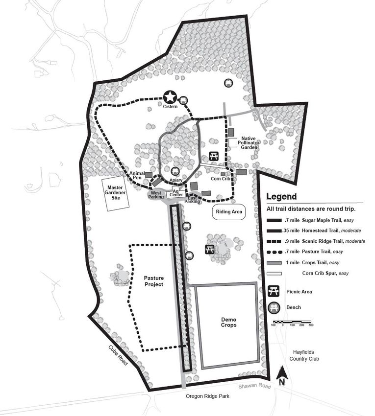
INDICATES TRAIL MARKERCenter for Maryland Agriculture & Farm Park: Scenic Ridge Trail Directions: Access the Scenic Ridge Trail from the west parking area near the Exhibit Barn. The marker is located near the cistern—the highest point in the Farm Park. GPS Coordinates: N 39 30’ 11”, W 76 41’ 07” Length: 0.9 miles round trip Difficulty: Easy – Moderate Features: The Farm Park’s trail system brings you up close and personal with agriculture’s past, present, and future. Here you can observe conventional crops, experimental plots, apiculture, demonstration gardens, livestock, historic farm buildings, and pastures. The public is encouraged to enjoy breathtakingly beautiful scenic vistas while exploring forests, wetlands, meadows, and farm-inspired art. This is a working demonstration farm. On any given day, you may catch fields being planted or harvested, bees being tended, or any of the many activities that are required to keep a farm productive. MAKE TRAIL MARKER RUBBING HERE
Oregon Ridge Park & Nature Center
            13555 Beaver Dam Road, Cockeysville, MD 21030
          (410) 887-1815 ● www.oregonridgenaturecenter.org
                      Park Hours: Sunrise to Sunset
          Nature Center Hours: 9am to 5pm, Tuesday – Sunday

Oregon Ridge Nature Center (ORNC) is located in the 1100+
acres of Oregon Ridge Park in Cockeysville, Maryland. As the
largest county park, it’s a little bit of wilderness where one can
hike over pristine streams, be under tall trees, and see varied
wildlife like white-tailed deer, frogs, and many types of birds.
Majestic tulip trees, sassafras, spicebush, and ephemeral
wildflowers add to the beauty of the trails.

The Nature Center, with ORNC Council’s support, offers
educational and outdoor opportunities to the public all year by
providing school field trips, seasonal hikes and nature programs,
campfires, canoeing trips, and special events. The Nature
Center houses a collection of live native animals and exhibits.
The park amenities include hiking trails, playgrounds, and picnic
areas. There are over 6 miles of hiking trails that visitors can use
year-round from sunrise to sunset with ample parking at two
locations.

Directions: Take 83 North to Exit 20B (Shawan Road West).
Follow Shawan Road to the first light, Beaver Dam Road, and
turn left. Make an immediate right and follow the driveway to
the parking lot. The Nature Center is located a short walk up the
driveway.
MAKE TRAIL MARKER RUBBING HERE
INDICATES TRAIL MARKER
MAKE TRAIL MARKER RUBBING HERE
INDICATES TRAIL MARKEROregon Ridge Park Red and Yellow Trail Markers
Oregon Ridge Park: Red Logger Trail
Directions: From the Nature Center parking lot, walk up the
driveway toward the nature center. Cross the bridge next to the
nature center and turn right onto the Red Trail. Cross the gas line
and turn right and walk along the wood line until the Red Trail picks
up again through the woods. The marker is shortly after the
shortcut trail. Take the Blue Trail for a more direct route back to the
parking lot/nature center.

Length: 1 mile to trail marker one-way.

GPS Coordinates: N39° 29.291’, W76° 41.535’

Difficulty: Moderate, varying terrains

Features: The park trails are blazed by color for easy identification.
Pets are permitted as long as they are on leashes. The trails will pass
by habitats in transition such as the gypsy moth devastation that
killed 18 acres of oak forest in 2006. This parcel of land is now in
succession from meadow to woodland with oak saplings. The Red
Trail will pass the Oregon Branch, where the trail is scattered with
pieces of garnets from the rock formation (mica schist) in the area.

Please note: the portion of the Red Trail that used to cut through
the lake is closed indefinitely. Please obey the signs and use the
Orange Trail detour to and from the gas line. The lake is closed for
all activities until further notice.
Oregon Ridge Park: Ivy Hill/St. James Campbell Yellow Trail
Directions: From the Nature Center parking lot, walk up the hill
toward the Nature Center. Cross the bridge next to the Nature
Center to begin hiking west on the Red Trail and then connect to
the Yellow Trail. When returning from the Yellow Trail, take the left
on the fork and head west onto the Red Trail. There are 2 possible
options on the return from the Red Trail: 1. Take the Green Trail and
it will continue onto the Orange Trail, where there is a rustic log
bridge and a view of the Oregon Ridge Lake, before it connects
back to the Red Trail; or 2. Take the Blue Trail for a more direct
route back to the parking lot/Nature Center.

GPS Coordinates: N39° 28.699’, W76° 41.266’

Length: 2 miles to trail marker one-way.

Difficulty: Moderate-Hard, occasionally rocky, varying terrains,
stream crossings

Features: The park trails are blazed by color for easy identification.
Pets are permitted as long as they are on leashes. The Yellow Trail
will cross over Baisman Run a few times. The Yellow Trail is more
strenuous than the Red Trail because of the elevation changes and
includes the Baisman Run crossings, which are just rocks lined up in
the stream. Therefore, rocks may be submerged or washed away
depending on storms. Feet may get wet, but it is worth the trip to
see the south side of the park, where there is a tranquil spot at the
Ivy Hill pond for a respite after finding the second Nature Quest
marker.
Marshy Point Park and Nature Center
          7130 Marshy Point Road, Middle River, MD 21220
             (410) 887-2817 ● www.marshypoint.org
                Nature Center Hours: 9am to 5pm daily
                     Park Hours: 9am to Sunset

Marshy Point is Baltimore County’s environmental education
center on the Upper Chesapeake Bay, and a part of the
National Park Service Chesapeake Gateways Network.

The Nature Center is open from 9am to 5pm every day and
park hours are 9am to sunset. The Nature Center provides a
variety of educational activities and the park has over 3 miles
of hiking trails to provide numerous opportunities for
exercise and exploration.

Directions: Marshy Point Park is
located at 7130 Marshy Point Road,
Middle River MD 21220 off of
Eastern Blvd, MD 150. From the
Baltimore Beltway take exit 31C,
Route 43 East, White Marsh
Boulevard. Follow 43 for 8 mi and make a left onto MD 150
East. After 2.5 mi on MD 150, make a right on Marshy Point
Road. Follow Marshy Point Road 0.5 mile to the Nature
Center parking area.

GPS Coordinates: N 39.35054, W -76.37878
Marshy Point Nature Center
Dundee-Saltpeter Trail Marker
INDICATES TRAIL MARKERMarshy Point: Dundee-Saltpeter Trail Description: Loop, following blue, red, and white blazed trails. Directions: Beginning at Marshy Point Nature Center, hike the Dundee- Saltpeter Trail (blue blaze) for 0.8 miles until you reach an overlook of Saltpeter Creek and the Trail Rubbing Marker. Follow the Dundee- Saltpeter Trail for another 0.2 miles until it intersects the Weiskittel Trail (red blaze) and follow it straight ahead, crossing the park road. Follow the Weiskittel Trail for 0.2 miles until it intersects the Whitetail Trail (white blaze). At the Whitetail Trail turn left and follow for 0.3 miles until you arrive back at the Nature Center. GPS Coordinates: 39.34440, -76.37386 Length: 1.5 miles Hiking Time: 45 minutes Difficulty: Easy and flat. Trail may be muddy after rain events. Features: Note the flat terrain of the coastal plain forest and enjoy views of Dundee and Saltpeter Creeks. Creeks like these serve as nursery and habitat for the birds, fish, mollusks, and crabs that make the Chesapeake Bay an important habitat and a unique ecosystem. MAKE TRAIL MARKER RUBBING HERE
Marshy Point Nature Center
Dundee Creek Canoe and Kayak Trail

          INDICATES TRAIL MARKER
Marshy Point: Dundee Creek Canoe and Kayak Trail Description: Canoe exploration. Must bring your own canoe or kayak. Directions: Put in at the Canoe Launch to enjoy exploration of the tidal creeks around Marshy Point. The Canoe Launch faces Dundee Creek looking toward the mouth of the Gunpowder River and the Chesapeake Bay. Enjoy a paddle through estuarine waters full of fish and crabs but be sure to paddle under the pedestrian bridge and into Minnow Branch Creek to find the Trail Rubbing Marker. GPS Coordinates: 39.35084, -76.37062 Length: Variable Time: Variable Difficulty: Moderate, depending on weather conditions, canoeing experience, wind, and tides. Features: Marshy Point offers canoe programs available to the public from April to November. Anyone with their own canoe or kayak is welcome to launch during park hours throughout the year, free of charge. Dundee creek offers a sheltered area for paddling and exploration with abundant wildlife to see at all times of the year. MAKE TRAIL MARKER RUBBING HERE
Benjamin Banneker Historical Park and Museum
                    300 Oella Ave, Catonsville, MD 21228
           (410) 887-1081 ● www.friendsofbenjaminbanneker.com
             Museum Hours: 10am to 4pm, Tuesday – Saturday
                       Park Hours: Sunrise to Sunset.

Encompassing 142 acres, with various facilities and extensive
nature trails, the primary focus of this site is cultural and
natural history. The historical park and museum is dedicated
to the legacy of the colonial farmer, clockmaker,
mathematician, astronomer, and federal territory surveyor,
Benjamin Banneker. Benjamin Banneker is known as the first
African American man of science.

The Banneker Museum features a permanent exhibition on
Benjamin Banneker's life and works, community gallery of
changing exhibits, gift shop, and patio garden. The site also
includes a colonial cabin, historic Victorian farmhouse, and
pavilion. The park and museum offers diverse programming
in history, culture, science, nature, environmental, and visual
and performing arts.

Directions: Take I-695 to exit 14, Edmondson Avenue.
Proceed west on Edmondson Avenue to the traffic circle and
exit onto Old Frederick Road (left). Turn right at the stop sign
on Oella Avenue. The park entrance is on the left.
Benjamin Banneker Historical Park and Museum
Trolley Trail
INDICATES TRAIL MARKER
MAKE TRAIL MARKER RUBBING HEREBenjamin Banneker Historical Park and Museum: Trolley Trail Directions: Follow the Yellow Trail, that begins behind the museum adjacent to the colonial cabin, downhill to the historic #9 Trolley Trail. At the Trolley Trail turn left and proceed to the marker on your left. GPS Coordinates: N 39.269009, W -76.78058 Length: 0.5 miles from museum to trail marker Hiking Time: 15 minutes to marker Difficulty: Easy Features: This 1 mile round-trip hike guides visitors through cool, dense second-growth woods on the historic Banneker farmstead, and along a small tributary of Cooper’s Branch which leads to the Patapsco River. You will pass two spring-fed wells and a man-made ice pond that served the inhabitants of this property and their livestock for hundreds of years. The #9 Trolley Trail dates from the late 1800s when an electric trolley line ran from Ellicott City into Catonsville and Baltimore. Notice the dominant rocks in the area: Ellicott City granite and Oella Schist. From the Nature Quest trail marker, you can proceed another 0.5 mile on the Trolley Trail to the Patapsco River and restaurants and shops in old Ellicott City.
Benjamin Banneker Historical Park and Museum

                    Red Trail

                INDICATES TRAIL MARKER

MAKE TRAIL MARKER RUBBING HERE
Benjamin Banneker Historical Park and Museum: Red Trail Directions: Take the Yellow Trail, which begins behind the museum, to the historic # 9 Trolley Trail (paved path). At the Trolley Trail turn left. Just past the storm water pond take the Red Trail on the left. Proceed uphill on the wooded Red Trail, continuing over two logs and turning right to follow the red trail markers. Follow the ridge through the beech/hickory forest. The marker is located at the top of the ridge where the red trail meets the blue trail. You can turn around and head back the way you came, or for a longer trek, continue along the red trail back to the Museum. GPS Coordinates: N 39.26676, W -76.86205 Length: 1 mile from museum to trail marker Hiking Time: 35 minutes to marker Difficulty: Moderate Features: This is one of the most scenic hikes in Banneker Park with delightful views of the Trolley Trail and Cooper’s Branch below. The trail winds through stands of mountain laurel, American beech, and pignut hickory. The property once belonged to Benjamin Banneker and later his friend, George Ellicott, who loaned him astronomy books and a telescope and started him on his brilliant studies of the heavens. Banneker undoubtedly traveled these trails in the late 1700s as he visited and shopped at the Ellicott Company store in what was then Ellicott’s Lower Mills.
Cromwell Valley Park
    2002 Cromwell Bridge Road, Baltimore, MD 21234
     (410) 887-2503 ● www.cromwellvalleypark.org
              Park Hours: Sunrise to Sunset
   Nature Center Hours: 9am to 4pm, Tuesday – Sunday

The 460-acre park was acquired by the Baltimore County
Department of Recreation and Parks starting in 1993. It is a stream
valley park comprised of pasture, cultivated gardens, open fields,
woods, hedgerows, orchards, and wooded piedmont hills. The
diversity of this habitat makes it an excellent area for wildlife.

The park is home to miles of hiking trails that range from stream
strolls on the Blue Trail along Minebank Run, to walks through
many meadows on the Yellow Trail, to more challenging hikes
through the woods on the Orange, Red, and Green Trails. Before
setting off, grab a trail map from the kiosks located at Willow Grove
& Sherwood Farm parking lots.

Directions: Baltimore Beltway, I-695 to Exit 29, Cromwell Bridge
Road. At the traffic light at the end of the exit ramp, turn left (east)
onto Cromwell Bridge Rd. Continue on Cromwell Bridge Rd past
Loch Raven High School. The first entrance to the Park is Sherwood
Farm.

   Do NOT turn into the Sherwood Farm entrance for Nature
                           Quest!

Go ½ mile past the Sherwood Farm entrance to the 2nd entrance,
Willow Grove Farm (2175 Cromwell Bridge Road). Turn left into the
driveway and continue across the bridge to the gravel parking lot.
Cromwell Valley Park
Blue Minebank Run Trail
INDICATES TRAIL MARKERCromwell Valley Park: Blue Minebank Run Trail
Description: Out & back following blue blazed trail.
Directions: Beginning at Willow Grove Farm parking lot, backtrack toward bridge
and turn left onto the Blue Trail just before bridge. Follow the Blue Trail along
Minebank Run, passing stone limekilns (on left), and a small “amphibian pond”
(on right), until reaching small section of wooden split rail fencing. Bear left at
fencing and proceed up mowed path to top of hill. Trail Rubbing Marker is
located near bluebird box #25, just past top of hill. Backtrack to parking lot on
same paths.
GPS Coordinates: N 39.414287, W 76.549609
Length: Just under 1 mile. Hiking Time: 30 minutes.
‘
Difficulty: Easy, flat except for short hill past split rail fencing.
Features: Cromwell Valley has been settled since the early 1700’s and used
primarily for agriculture, pasture, and woodlands. The area was formerly known
as “Lime Kiln Bottom,” owing to the numerous limekilns that were located in the
valley beginning in the mid 1800’s. You will pass three of these kilns along this
hike. The kilns used wood harvested from the nearby hillside to heat marble,
creating lime powder. The lime powder was then collected and bagged at the
base of the kilns. The lime kilns in the valley operated until the 1920’s.
MAKE TRAIL MARKER RUBBING HERECromwell Valley Park Red Willow Grove Trail
Cromwell Valley Park: Red Willow Grove Trail
Description: Out & back following red blazed trail.

Directions: Beginning at Willow Grove Farm parking lot, turn left onto
paved road (Red Trail) and proceed past Nature Education Center, toward
Willow Grove Barn. Follow red blazes up gravel path, past post & cable
barrier. Continue on Red Trail, past entrances to the Yellow Trail, and bear
left into woods. Follow red blazes uphill until reaching split in Red Trail at
very top of hill. Trail Rubbing Marker is located at split in Red Trail, next to
wooden bench. Backtrack to parking lot on same trail.

GPS Coordinates: N 39.421727, W 76.552514

Length: Just under 1.2 miles.         Hiking Time: 1 ¼ hours.

Difficulty: Hilly, moderately strenuous.

Features: Big trees are the primary feature of this challenging trail through
woodland habitat, along an abandoned farm lane. Oak, tulip tree, and beech
are the dominant tree species. Understory vegetation includes spicebush,
sassafras, and viburnums.

  MAKE TRAIL MARKER RUBBING HERE
Honeygo Run Regional Park
                    9033 Honeygo Boulevard, Perry Hall, MD 21128
                    (410) 887-3681 ● www.leaguelineup.com/hrrp
                             Park Hours: Sunrise to Sunset

Honeygo Run Regional Park is a 150 acre park that provides a variety of
outdoor and indoor recreation facilities. Facilities include ball diamonds,
athletic fields, roller hockey court, playground, pavilions, dog park
(membership required), and recreation center. Hikers will enjoy our paved
walking path and miles of beautiful forested trails.

1. Directions from points west of the intersection of White Marsh Boulevard
  (Rt. 43) and I-695: From the Baltimore Beltway (I-695) take exit 31C for
  White Marsh Boulevard East. Continue on White Marsh Boulevard for
  approximately 3.5 miles and make a left onto Honeygo Boulevard.
  Proceed north on Honeygo Boulevard for approximately one mile and
  make a right into the park entrance just past the overhead pedestrian
  bridge.

2. Directions from points east of the intersection of White Marsh Boulevard
  and I-695: From the Baltimore Beltway (I-695) take exit 33 for I-95 North.
  Continue on I-95 North for approximately three miles and take exit 67 for
  White Marsh Boulevard West (toward White Marsh Town Center). Proceed
  to the first stoplight and make a right onto Honeygo Boulevard. Follow
  Honeygo Boulevard North for approximately one mile and make a right
  into the park entrance just past the overhead pedestrian bridge.
Honeygo Run Regional Park Red Trail Marker INDICATES TRAIL MARKER
Honeygo Run Regional Park: Red Trail
Directions: Walk behind the recreation center and towards the
fenced athletic field. Take the paved walkway between the dog park
and the fenced field. The trail entrance will be on your left. Follow
the signs and the red tree blazes to the trail marker.

GPS Coordinates: N 39.389297, W -76.444688

Length: 0.5 miles to marker          Difficulty: Easy

Features: The Red Trail will take you through a forest of oak, maple,
hickory, sassafras, and more while offering views of the nearby
stream, Honeygo Run. A variety of spring ephemeral wildflowers
can be found along the trail.

  MAKE TRAIL MARKER RUBBING HERE
Red Run Stream Valley Trail
                             Owings Mills Recreation Office
                               4931 New Town Boulevard
                                Owings Mills, MD 21117
                    (410) 887-1582 ● www.leaguelineup.com/omrpc
                              Park Hours: Sunrise to Sunset

The Red Run Stream Valley Trail is located in Owings Mills and features both
mulch paths and paved paths suitable for wheelchairs, bicycles, or strollers.
The trail is surrounded by woods and goes directly through Soliders Delight
Natural Environmental Area.

Parking is available in two locations: along Lakeside Boulevard, and after the
intersection of Dolfield Road and Pleasant Hill Road, past the bridge.

Please Note: Nature Quest prizes and booklets cannot be picked up at this
location.

Directions: from 695, take exit 19 to merge onto I-795 N (Northwest
Expressway) toward Reisterstown/Owings Mills, then take exit 4 for Owings
Mills. Keep left at the fork, then follow signs for Owings Mills Boulevard
South and merge onto Owings Mills Boulevard. Turn right onto Lakeside
Boulevard. The Lakeside Spur of the trail will be on your right, just before
Silverbrook Lane.
Red Run Stream Valley Trail
Walnut Grove Trail Marker
P
P
INDICATES TRAIL MARKERRed Run Stream Valley: Walnut Grove Trail Directions: From the parking area near Red Run Boulevard, take the path marked “Main Trail” on your map. The Nature Quest marker can be found on the “Walnut Grove Trail Loop” sign at the intersection of one of the Overlook paths. GPS Coordinates: N 39.41089, W -76.80516 Length: About 0.7 miles to marker Difficulty: Easy Features: This is a trail with paved sections that are suitable for bicycles and strollers. This trail runs alongside Red Run Stream, and to the west (outside the area of your map), the trail leads toward Soliders Delight Natural Environmental Area, which features unique and globally rare serpentine barrens. MAKE TRAIL MARKER RUBBING HERE
Red Run Stream Valley: Woodland Trail
Directions: From the parking area near Red Run Boulevard, take
the Main Trail to the first trail on the left (labeled “Nature Trail” on
your map). The marker is on the railing of a bridge.

GPS Coordinates: N 39.40824, W -76.8009

Length: 0.61 miles to marker           Difficulty: Easy, with hills

Features: This is a shaded trail surrounded by forest, with several
wooden bridges over Red Run Stream. There are paved and mulch
sections of this trail.

  MAKE TRAIL MARKER RUBBING HERE
Fort Howard Park
                                 9500 North Point Road
                                Fort Howard, MD 21052
                                 http://www.esprec.com
                              Park Hours: Sunrise to Sunset
                            Park Closed October - November

Located on the tip of the North Point peninsula in the southeastern corner of
Baltimore County, Fort Howard Park sits on a mile of waterfront at the mouth
of the Patapsco River where it empties into the Chesapeake Bay.

The park and the surrounding area are steeped in military history. In 1814, forty
ships of the British navy sailed into the Patapsco and landed an invasion force of
4500 redcoats at North Point intending to attack and burn Baltimore. American
forces met the British troops a few miles north of the present day park. That
engagement is called the Battle of North Point.
In 1899, the property where the park is located was purchased by the army and a
coast artillery installation was built. It was named Fort Howard in honor of John
Eager Howard, a Revolutionary War hero and early governor of Maryland.

By 1903, the fort housed 18 huge artillery pieces designed to protect Baltimore
from another attack by enemy ships. The hulking concrete gun batteries still
dominate the park. Visitors can climb onto the structures and learn about the
guns that were once emplaced in them from the ten historical panels that dot the
park.

In addition to its historical aspect, Fort Howard Park features covered pavilions,
playgrounds, a fishing pier, and miles of trails throughout the property.

Please Note: Nature Quest prizes and booklets cannot be picked up at this
location.

Directions: Fort Howard Park is located at the end of North Point Road. Take the
Edgemere exit off the Baltimore Beltway (695) and follow the signs to the park.
Fort Howard Park Gun Battery Trail INDICATES TRAIL MARKER
Fort Howard Park: Gun Battery Trail
Directions: While facing the bulletin board in the parking lot at the park,
take the paved pathway to your left. When you see the playground,
continue down the pathway to the left. The marker will be located on the
Battery Clagett sign.

GPS Coordinates: N 39.19891, W -76.44037

Length: 0.5 miles to marker          Difficulty: Easy

Features: The trail at Fort Howard Park is unique in that you can access an
online Do It Yourself Tour Guide to learn about the various historical sites
along the trail. Using this QR code (also posted on the bulletin board in the
park) will take you to the Friends of Fort Howard Park website, where you
can find the link to download the Tour Guide document. Follow the
directions it provides and you are off on a 1.25 mile hike through Baltimore
County history.

                 www.esprec.com/site/ClientSite/article/1870258

  MAKE TRAIL MARKER RUBBING HERE
Hiking Tips Crossword
Make sure you are prepared for your journey through Baltimore’s parks.
Complete this crossword by figuring out the hiking tips below.
(Answers on next page.)
ACROSS
4. Know before you go: read one of these and plan which trails to take.
6. Remember to pack these to eat on the trail.
7. “Leave No Trace” by using this kind of container for your necessities.
9. This kit should include bandages, antiseptic, and tweezers, among other supplies.
DOWN
1. Some trails are for hiking only, but others are also for people riding these.
2. Bring this with you to stay hydrated.
3. Wear layers so that you can be prepared for any kind of ___________.
5. Know how to identify this three-leafed plant so that you can avoid it.
8. Don’t hike alone, bring one of these with you.
10. Make sure you have a pair that is comfortable and closed-toed.Nature Quest Fest
Held Annually Each Fall
Hold on to your Passport! If you have completed at least 5 trails,
your passport is your free admission ticket to the Nature Quest Fest
held each year in the fall (date and time to be announced by Lake
Roland on www.LakeRoland.org).
Nature Quest Fest is an exciting celebration and will include
multiple activities such as canoeing, archery, meeting live animals,
fishing, and more. Be sure to RSVP at one of the parks when you
collect your prizes! For more information, call us at 410-887-4156,
or email LakeRol-RP@BaltimoreCountyMD.gov.
Redeem Your Completed Passport for Prizes
A park stamp certifies a completed Nature Quest Hit the Trails Passport.
When you present your passport booklet to receive your prize, a park staff
member will stamp here to show you have completed 5 or more trails.
___________________
Park Staff: Stamp in this Box Date CompletedCrossword Answers: 1. Bikes 2. Water 3. Weather 4. Trail map 5. Poison Ivy 6. Snacks 7. Reusable 8. Buddy 9. First Aid 10. Shoes
You can also read