Groundwater Recharge New Jersey Stormwater Best Management Practices Manual
←
→
Page content transcription
If your browser does not render page correctly, please read the page content below
New Jersey Stormwater
     Best Management Practices Manual
                                             April 2004

                                C H A P T E R                   6

          Groundwater Recharge
This chapter presents the standards, data, and procedures necessary to meet the groundwater recharge
requirements of the NJDEP Stormwater Management Rules at N.J.A.C. 7:8. According to these Rules, a
“major development” project, which is one that disturbs at least 1 acre of land or creates at least 0.25 acres
of new or additional impervious surface, must include nonstructural and/or structural stormwater
management measures that prevent the loss of groundwater recharge at the project site. This requirement is
included in the Rules because the loss of groundwater recharge can adversely impact the health of streams
and wetlands and the yield of water supply wells. Urban redevelopment and certain linear development
projects are exempt from the groundwater recharge requirements, while waivers may obtained under certain
conditions for public roadway, railroad, and pedestrian walkway enlargements. Complete details can be
found in Subchapter 5 of the Stormwater Management Rules.
   Specifically, the Stormwater Management Rules require that a proposed major land development comply
with one of the following two groundwater recharge requirements:
     Requirement 1:     That 100 percent of the site’s average annual pre-developed groundwater recharge
                        volume be maintained after development; or
     Requirement 2:     That 100 percent of the difference between the site’s pre- and post-development 2-
                        Year runoff volumes be infiltrated.
    The Stormwater Management Rules allow the site designer to select which requirement to follow. The
Rules also state that compliance with either of the above alternative requirements must be demonstrated
through hydrologic and hydraulic analysis. Regardless of which alternative requirement is selected, such an
analysis will generally begin with a computation of the existing (or pre-developed) hydrologic conditions at
the proposed development site. In the case of Requirement 1, these conditions will focus on the annual
amount of groundwater recharge that occurs at the site under pre-developed conditions while, for
Requirement 2, the focus will instead be on the pre-developed volume of 2-Year site runoff.
    These computations will then be followed by similar ones for the proposed (or post-developed) conditions
at the site. A comparison of the results of either of these pre- and post-development computations will then
yield the annual volume of groundwater that must be recharged (Requirement 1) or 2-Year storm runoff
volume that must be infiltrated (Requirement 2) through one or more structural recharge or infiltration
BMPs. Ideally, the planning and design of the proposed site will have incorporated nonstructural measures to
such an extent that the need for structural facilities is reduced to a practical minimum.
Finally, once the analysis of pre- and post-development conditions has established the need for structural
recharge (Requirement 1) or infiltration (Requirement 2) BMPs, the hydrologic and hydraulic analysis
would next focus on the actual design of such facilities. This process would include answering such
questions such as:
• Should the required recharge or infiltration be achieved at a single facility or several located
throughout the development site?
• Should the facilities be located above or below ground?
• Which portions of the development site should be utilized to generate runoff to the facilities?
• What facility dimensions are required?
• Where should the facilities be located on the site relative to buildings, septic systems, property
lines, and other sensitive areas?
This chapter presents the groundwater recharge information necessary to perform the hydrologic and
hydraulic analysis required for Requirement 1 (maintaining pre-developed annual recharge volumes).
Information necessary for the analysis required for Requirement 2 (infiltrating the increased 2-Year runoff
volume) is presented in Chapter 5: Computing Stormwater Runoff Rates and Volumes. Design information
regarding structural recharge and infiltration BMPs can be found in this chapter and Chapter 9: Structural
Stormwater Management Measures.
Fundamentals
In both the NJDEP Stormwater Management Rules and this manual, groundwater recharge is defined as
precipitation that infiltrates into the soil and is not evapotranspired. Instead, the infiltrated precipitation
moves downward to a depth below the root zone of the surface vegetation, where it cannot be removed by
that vegetation through uptake and evapotranspiration. At such a depth, it is considered available to enter
the soil’s saturated zone and become groundwater. The role of groundwater recharge in the overall
hydrologic cycle is illustrated in Figure 6-1 below.
Figure 6-1: Groundwater Recharge in the Hydrologic Cycle
Source: New Jersey Geological Survey Report GSR-32.
New Jersey Stormwater Best Management Practices Manual • Chapter 6: Groundwater Recharge • April 2004 • Page 6-2According to the New Jersey Geological Survey (NJGS):
The potential for natural groundwater recharge begins with precipitation (rain, snow, hail, sleet). Some
of the precipitation never seeps into the soil, but instead leaves the system as surface runoff. The water
that seeps into the soil is infiltration. Part of the water that does infiltrate is returned to the atmosphere
through evapotranspiration. Evapotranspiration refers to water that is returned to the atmosphere
from vegetated areas by evaporation from the soil and plant surfaces and soil water that is taken up by
plant roots and transpired through plant leaves or needles. Infiltrated water that is not returned to the
atmosphere by evapotranspiration moves vertically downward and, upon reaching the saturated zone,
becomes ground water. This ground water could be in a geologic material that is either an aquifer or
nonaquifer, depending on whether it can yield satisfactory quantities to wells. (NJGS GSR-32)
In addition to supplying water to wells, groundwater can also provide base flow to streams, wetlands,
and other water bodies, directly affecting the ecology and geomorphology of these resources.
The potentially adverse impacts of land development on groundwater recharge have long been
recognized. From the description presented above, it can be seen that land development activities that either
cover permeable soils with impervious surfaces or reduce the soils’ permeability through disturbance and
compaction will reduce the rate of groundwater recharge that occurs under pre-developed site conditions.
As noted above, such reductions in groundwater recharge can adversely impact streams, wetlands, and
other water bodies by reducing the volume and rate of base flow to them. Reductions in groundwater
recharge to aquifers can also adversely impact the yield of water supply wells. As a result, the New Jersey
Stormwater Management Rules require that pre-developed groundwater recharge rates be maintained at
land development sites under post-development conditions.
New Jersey Stormwater Best Management Practices Manual • Chapter 6: Groundwater Recharge • April 2004 • Page 6-3Computing Groundwater Recharge
Overview
As described above, the groundwater recharge requirements of the NJDEP Stormwater Management Rules
can be met by demonstrating that the average volume of precipitation that is annually recharged to the
groundwater at a major land development site under pre-developed conditions will be maintained following
site development. As described in detail below, this can be achieved through a combination of natural
recharge over the developed site’s pervious surfaces and artificial recharge through groundwater recharge
BMPs constructed at the site. The BMP volume is based on an average annual distribution of runoff-
producing precipitation events at the site, the impervious drainage area to the BMP, and the losses that may
occur to the infiltrated runoff before it can travel below the root zone of surrounding vegetation and become
groundwater.
The data and analytic procedures necessary to meet these requirements have been developed by the New
Jersey Department of Environmental Protection (NJDEP) with assistance from the New Jersey Geologic
Survey (NJGS), the U.S. Geologic Survey (USGS), and professional consultants, and have been compiled
into the New Jersey Groundwater Recharge Spreadsheet (NJGRS), a Microsoft Excel-based computer
spreadsheet program. The NJGRS is intended for use by site planners, designers, engineers, and reviewers to
determine average annual groundwater recharge amounts under both pre- and post-development site
conditions and to design the groundwater recharge BMPs necessary to maintain 100 percent of the pre-
developed site’s annual groundwater recharge rate. Information regarding the NJGRS, including a detailed
User’s Guide, an example problem, and instructions on how to download the NJGRS from the NJDEP
stormwater management website, is presented below. Details of the program’s theoretical basis, equations,
and supporting databases are also summarized.
In general, the analytic procedures utilized by the NJGRS to achieve compliance with the groundwater
recharge requirements of the Stormwater Management Rules (described as Requirement 1 above) can be
summarized by the following computational steps:
1. Compute the average amount of annual groundwater recharge occurring over the land
development site under pre-developed site conditions.
2. Compute the average amount of annual groundwater recharge occurring over the land
development site under post-developed conditions. Such site conditions should reflect the use, to
the maximum extent practicable, of nonstructural stormwater management measures at the post-
developed site in accordance with the Stormwater Management Rules. Details of such
nonstructural measures are presented in Chapter 2: Low Impact Development Techniques.
3. Compute any resulting annual groundwater recharge deficit by subtracting the post-developed
annual recharge amount in Step 2 from the pre-developed annual amount in Step 1. This deficit
represents the average annual amount of groundwater recharge that must be achieved at the
development site through structural groundwater recharge BMPs.
4. Determine the storage volume and related dimensions of the structural groundwater recharge BMP
that will be required to satisfy the average annual groundwater recharge deficit computed in Step
3 above. In doing so, the BMP volume must be based on the average annual distribution of runoff-
producing precipitation events at the development site, the size of the drainage area over which
these events will occur (and from which runoff will be collected or captured for recharge), and the
infiltration, evapotranspiration, and other losses that may occur to the recharged runoff in the
BMP before it can actually enter the groundwater.
New Jersey Stormwater Best Management Practices Manual • Chapter 6: Groundwater Recharge • April 2004 • Page 6-4Theoretical Basis of Computations
Computation of the average annual groundwater recharge at a land development site under either pre- or
post-developed conditions (as described above in Steps 1 and 2) can be performed with the New Jersey
Groundwater Recharge Spreadsheet (NJGRS). This Microsoft Excel-based spreadsheet is based on the data
and computational procedures contained in the 1993 Geological Survey Report GSR-32: A Method for
Evaluating Ground Water Recharge Areas in New Jersey developed by the NJGS. As described in the report,
GSR-32 utilizes precipitation, soil, land cover, and climate data, and rainfall-runoff and mass balance
computations to estimate average annual groundwater recharge amounts at sites within any New Jersey
municipality under a variety of surface and development conditions. All pertinent GSR-32 databases and
computational algorithms have been incorporated into the NJGRS. As such, use of the NJGRS is governed,
in part, by the assumptions and limitations of GSR-32.
Design of the required recharge BMP (as described in Step 4 above) to compensate for the developed
site’s groundwater recharge deficit (as described in Step 3 above) can also be performed with the NJGRS.
The design computations in the NJGRS are based on a number of analytic techniques and databases.
Conceptually, a groundwater recharge BMP will recharge the runoff it receives from its drainage area for all
storms up to a particular precipitation depth, which can be referred to as the BMP’s groundwater recharge
design storm. While the recharge BMP will also receive runoff from larger storms, it will only recharge that
portion of the runoff that equals the Recharge Design Storm runoff. The remaining runoff from these larger
storms will overflow or otherwise bypass the BMP. It is important to note that the range of precipitation
depths typically involved in the design of a groundwater recharge BMP are relatively small when compared
to depths associated with runoff quality or quantity control. As a result, the NJGRS requires that the entire
drainage area to a recharge BMP be impervious, since pervious surfaces would typically not be able to
produce a sufficient amount of rechargeable runoff from such small precipitation depths.
Assuming that all of the precipitation falling in a recharge BMP’s impervious drainage area can be
collected and recharged (i.e., no runoff, infiltration, or recharge losses), computation of the BMP’s Recharge
Design Storm depth can be conceptually illustrated with the following conversion equation:
Total Average Annual Sum of Number of
Recharge Design
Annual Recharge = Recharge Design and
+ Storm Depth
x Larger
Deficit Smaller Storm Storms
Depths
The above equation shows that, with appropriate precipitation data and ignoring all losses, the total
annual recharge deficit at a land development site can be converted to the sum of two precipitation
amounts, both of which are based on a single groundwater recharge design storm. The first amount is the
sum of all storm depths up to and including the Recharge Design Storm that would occur at the site in an
average year. The second amount is the product of the Recharge Design Storm depth times the number of
larger storms that would also occur at the site in that same average year.
Unfortunately, most of the ease and simplicity of the conversion equation shown above is gained through
its two assumptions: that appropriate precipitation data is available, and that all of the precipitation falling
on the BMP’s impervious drainage area can be recharged without loss. In reality, compiling such
precipitation data for a specific land development site requires considerable effort and resources and must
be repeated for each new development site. In addition, precipitation losses will occur and must be taken
into consideration in the design of a recharge BMP. As noted above, these losses, which will vary with the
total precipitation depth, include those occurring in the conversion of precipitation to runoff, including
surface storage, evaporation, and infiltration through cracks, joints, and seams in the drainage area’s
impervious surface. Further losses will occur once the runoff is delivered to the recharge BMP, primarily in
New Jersey Stormwater Best Management Practices Manual • Chapter 6: Groundwater Recharge • April 2004 • Page 6-5the form of evapotranspiration by the vegetation above, beneath, and/or adjacent to the BMP. Further
complications arise when one attempts to estimate these variable losses. While equations exist to predict
such losses for individual storm events, there are none readily available that can do so for an annual
precipitation depth.
The NJGRS addresses these problems in several ways. Regarding the need for appropriate precipitation
data for all possible development site locations in New Jersey, the NJGRS developers compiled and analyzed
52 years of daily precipitation data collected at 92 precipitation stations throughout New Jersey between
1948 and 1999. To ensure a proper database, only precipitation depths greater than 0.04 inches were
considered, since this depth was considered the minimum amount necessary to produce runoff from
impervious surfaces. All daily values at each station were sorted for each year and then averaged over the 52
year period of record. Next, all values with the same rank were averaged across all 92 stations to produce an
average annual series of 79 precipitation events for the state. Finally, this series was normalized by dividing
each event value by 46.32 inches, which was the average annual precipitation for the 92 stations. This
produced an average annual series of 79 precipitation events, expressed as a percentage of total annual
precipitation, that are analyzed individually by the NJGRS to compute the runoff, infiltration, and recharge
losses and the resulting annual groundwater recharge achieved by a recharge BMP at a land development
site in any New Jersey municipality.
This average annual series of precipitation events for New Jersey is shown below in Figures 6-2 and 6-3.
Figure 6-2 depicts the precipitation depth, expressed as a percentage of total average annual rainfall, of each
event in the series in ascending order, while Figure 6-3 depicts, also in ascending order, the events’
cumulative percentage of the average annual rainfall. More detailed information about each specific event in
the average annual series is contained in the NJGRS’ databases. The average annual precipitation series
shown in Figure 6-2 is used by NJGRS to produce a site-specific, year-long series of design storms by
multiplying each event value in the series by the average annual precipitation in the municipality where the
recharge BMP is located. Since the NJGRS also contains average annual precipitation values for each New
Jersey municipality, the NJGRS user can generate this site-specific average annual design series simply by
specifying the municipality and county in which the development site is located.
New Jersey Stormwater Best Management Practices Manual • Chapter 6: Groundwater Recharge • April 2004 • Page 6-6Figure 6-2: Average Annual Precipitation Series in NJGRS
Figure 6-3: Cumulative Total of Average Annual Precipitation Series in NJGRS
New Jersey Stormwater Best Management Practices Manual • Chapter 6: Groundwater Recharge • April 2004 • Page 6-7Once an average annual design series is computed for the specific recharge BMP site, the NJGRS next
addresses the problem of precipitation losses. As noted above, all of the possible losses that will occur, from
the time the precipitation falls on the BMP’s impervious drainage area to when the recharged water moves
below the root zone of the vegetation in or adjacent to the BMP, must be accounted for in order to
accurately compute the actual volume that will be recharged. Such losses can include infiltration and surface
storage losses on the drainage area surface as the precipitation is converted into runoff, as well as
evapotranspiration and infiltration losses as the runoff is converted to recharge within the BMP itself. To
compute runoff losses, the NJGRS uses one of three equations depending upon the total depth of the event.
These equations are applied to each event in the average annual design series to compute the resultant
runoff for each one. This resultant runoff is then used in additional equations that estimate the losses that
will occur for each design event once the runoff enters the recharge BMP.
When computing runoff losses for design event depths less than 0.0408 inches, the NJGRS assumes that
the entire precipitation depth is consumed by surface storage, infiltration, and other losses and no runoff is
produced.
For design event depths between 0.04 and 1.25 inches, the NJGRS uses the following equation to
compute runoff:
Q = 0.95 (P - 0.0408) 0.90
where:
Q = Runoff Depth in Inches
P = Precipitation Depth in Inches
For design event depths greater than 1.25 inches, the NJGRS uses the NRCS Runoff Equation with a
Runoff Curve Number (CN) of 98:
Q = (P – 0.04)2
(P + 0.16)
where:
Q = Runoff Depth in Inches
P = Precipitation Depth in Inches
As noted above, the resultant runoff depth for each design event is then applied to specialized equations
developed specifically for the NJGRS to estimate the losses that will occur to the runoff after it is stored in
the recharge BMP. These losses will depend upon a number of factors, including the climate at the
development site, the specific vegetation and soil conditions at the recharge BMP location, and the depth of
the BMP relative to the vegetation’s root zone. A complete description of the loss equations used in the
NJGRS is presented in the program’s User’s Guide. By subtracting these losses from the stored runoff, the
amount of runoff that is actually recharged for each design event is computed. The NJGRS then adds up the
recharge amounts from each design event to obtain a total annual recharge amount, which is then compared
with the average annual recharge deficit created by the development to determine whether the recharge
BMP’s performance is adequate. Similar to the computation of the average annual design series described
above, the NJGRS’ loss computations are performed automatically each time the user provides new
development site or recharge BMP data and then requests a BMP design update. The NJGRS will then either
evaluate the performance of the proposed recharge BMP or, if requested, compute the effective BMP storage
depth or surface area necessary to offset the development’s annual recharge deficit.
New Jersey Stormwater Best Management Practices Manual • Chapter 6: Groundwater Recharge • April 2004 • Page 6-8New Jersey Groundwater Recharge Spreadsheet (NJGRS)
General Instructions
As described above, the New Jersey Groundwater Recharge Spreadsheet (NJGRS) is a Microsoft Excel-based
computer spreadsheet program. It is typically used in a two step procedure, utilizing first the Annual
Recharge worksheet and then the BMP Calculations worksheet in the program. During the first step, the
average annual groundwater recharge amounts at the site under pre- and post-developed conditions are
estimated based upon site data provided by the user. From these estimates, the program computes the
average annual groundwater recharge deficit caused by the site development that must be offset by a
groundwater recharge BMP. During the second step, this recharge BMP is sized based upon user-specified
information regarding both the BMP and its location at the development site. General information regarding
each step is provided below. Specific information about the program’s use and computation methods are
provided in the NJGRS User’s Guide, which is presented at the end of this chapter.
It should be noted that, as a spreadsheet, certain cells of the program are reserved for user input while
others provide intermediate and final results. All user input cells are shaded with a tan color while
spreadsheet output cells are shaded with gray. Only the tan, user-input cells should be changed. In
addition, the spreadsheet contains several combinations of commands known as macros. While these
macros are essential to the spreadsheet’s operations, they are unsigned and, as such, their presence may
conflict with the Excel program’s security settings in the user’s computer. These conflicts would be
identified to the user through an error or warning message immediately after opening the NJGRS. If such
conflicts are encountered, they can usually be addressed by setting the Excel macro security level to
Medium. The user should determine whether this level of security is acceptable for their own system. The user
would then be prompted to enable the NJGRS macros each time the spreadsheet is opened.
Finally, upon completing use of the NJGRS for a specific project, the user will be asked whether the
changes made during use should be saved. While such decisions are at the discretion of each user, it may be
helpful for training purposes to retain the spreadsheet original settings, which match those in the NJGRS
User’s Guide. In this case, a copy of the revised NJGRS with project specific data entered can be saved with
a project-specific name using the Save As command under File on the Excel command line.
Annual Recharge Worksheet
Annual groundwater recharge at a land development site under both pre- and post-developed (or existing
and proposed) site conditions can be estimated using the Annual Recharge worksheet in the NJGRS. As
discussed above, these estimates are based on the methodology contained in Geological Survey Report GSR-
32: A Method for Evaluating Ground Water Recharge Areas in New Jersey (GSR-32) developed by the New
Jersey Geological Survey. In general, use of this worksheet requires the following user input:
1. Name of municipality and county in which the project site is located (Cell C3). Upon input of this
data through use of a drop-down list, the NJGRS will immediately display the average annual
precipitation and climate factor for the site’s municipality from the GSR-32 databases in the
NJGRS. The user can also specify a project name, description, and date in the lines provided
(Cells K1, K2, and K3).
2. Land use and land cover (LULC) data for the site under both pre- and post-developed conditions.
This data will consist of the area (in acres), LULC characteristics, and soil series name for up to 15
land segments of the pre- and post-developed site. The NJGRS will issue a warning message if the
total area specified under pre-developed conditions is different than post-developed. The LULC
data and soil series names are listed in a drop-down list next to the respective input cells. It is
New Jersey Stormwater Best Management Practices Manual • Chapter 6: Groundwater Recharge • April 2004 • Page 6-9important to note that the LULC categories in the drop-down list are based on those contained in
Table 2-2 of the NRCS Technical Release 55 – Urban Hydrology for Small Watersheds. For a
correlation between these LULC categories and those in GSR-32, upon which the NJGRS is based,
see Table 6-1 below.
Table 6-1: NJGRS/TR-55 and GSR-32 LULC Descriptions
NJGRS/TR-55 LULC Descriptions GSR-32 LULC Descriptions
Brush Brush
Gravel, Dirt Unvegetated
Impervious Areas Unlandscaped Developed
Meadow, Pasture, Grassland or Range Agricultural – Pasture
Open Space Landscape Open Space
Residential 1 to 2 Acre 1 - 2 Acre Lots
Residential 1/2 to 1 Acre 1/2 - 1 Acre Lots
Residential 1/3 to 1/4 Acre 1/8 - 1/2 Acre Lots
Residential 1/8 Acre or Less 1/8 Acre Lots
Row Crop Agricultural – General
Small Grain or Legumes Agricultural – Cropland, Legume
Urban Districts Landscaped Developed
Woods Woods
Woods – Grass Combination Wooded – General
As noted in the NJGRS User’s Guide, it is important to specify a site’s LULC characteristics as accurately
as possible. Therefore, while a 1/4 acre residential site could be specified in the NJGRS by the “Residential
1/3 to 1/4 Acre” LULC description in Table 6-1, it is generally more accurate to divide the site into
impervious and pervious areas and specify each as a separate land segment in the NJGRS. For example, at a
1/4 acre residential site with a total area of 10 acres consisting of 40 percent connected impervious and 60
percent grassed surfaces and a single soil series, it would be more appropriate to specify the site’s LULC
characteristics in the program as a separate 4 acre impervious area land segment and a 6 acre open space
land segment. This separation of connected impervious and pervious areas is similar to the technique for
computing runoff volume using the NRCS methodology in Chapter 5. It should be noted that the total
impervious area for post-developed conditions displayed in Cell M23 of the Annual Recharge worksheet
will be based only on those post-developed land segments specified as impervious.
When using the above technique, it should be noted that if any impervious areas at a development site
are unconnected (see Chapters 2 and 5 for complete details and requirements), the area used in the
impervious surface designations described above for these unconnected areas should be one half of the
actual area. For example, if a site has 3 acres of directly connected impervious surface, but 2 acres of
unconnected impervious area, the total impervious area specified in the NJGRS can be 3 + (0.5)(2) or 4
New Jersey Stormwater Best Management Practices Manual • Chapter 6: Groundwater Recharge • April 2004 • Page 6-10acres. This 50 percent reduction in the size of unconnected impervious areas accounts for the runoff re-
infiltration that can occur downstream of such areas and is consistent with the runoff computations for such
areas contained in TR-55. To keep the total site area correct, the user should remember to specify the
“remainder” of the unconnected impervious area as a pervious one with the appropriate soil series and
LULC based upon the actual pervious area downstream of the unconnected impervious area.
It should also be noted that if a proposed recharge BMP will have a specific location within a land
development site with similarly specific LULC and soil characteristics, that portion of the site should be
specified as a separate land segment on the Annual Recharge worksheet. This is true even if that segment
will be covered with an impervious surface. Doing this will allow the NJGRS to more accurately compute
the losses and resultant recharge at the BMP. More details are presented below in the NJGRS User’s Guide,
including the need to specify this segment on the BMP Calculation worksheet.
From the above, it can be seen that the more generalized Residential and Urban District LULC
descriptions in Table 6-1 above should be used only for general planning studies of groundwater recharge
requirements, particularly at sites with multiple lots of similar size and impervious coverage where each lot
will have a separate groundwater recharge BMP. Since the soil series in which each BMP will be located may
vary from lot to lot, the general LULC descriptions can be used to compute typical or general groundwater
recharge requirements and BMP dimensions for the entire site. These general values can then be refined on a
lot by lot basis during later, more detailed project phases with specific lot and BMP information.
Finally, in accordance with NJGS Report GSR-32, which is the basis of the NJGRS, zero recharge volume
will be computed for any land segment specified for either pre- or post-development conditions that contain
soils that are hydric. See Report GSR-32 for more details.
BMP Calculations Worksheet
The dimensions of a groundwater recharge BMP can be either determined or tested using the BMP
Calculations worksheet in the NJGRS. This worksheet can be used to calculate the effective depth required
at a recharge BMP if the impervious drainage area and BMP area are specified. Conversely, the worksheet
can also be used to calculate the required area of the BMP if the drainage area and effective BMP depth are
specified. Finally, the BMP Calculations worksheet can be used to analyze a specific recharge BMP with a
certain area and effective depth to see what amount of annual groundwater recharge it can provide.
As explained in the NJGRS User’s Guide, it is critical that the surface area of a recharge BMP (variable
ABMP) be specified in the program as accurately as possible. This is because the program uses the ratio of
the BMP’s drainage area and surface area to determine the resultant depth of runoff in the BMP for each
storm event analyzed. In addition, a recharge BMP’s effective depth (variable dBMP) represents the
maximum equivalent water depth that can be achieved in the BMP before overflow begins. Therefore, if the
proposed recharge BMP will consist, for example, of a subsurface, vertical-walled chamber, dBMP will
simply be the maximum achievable depth before the chamber is full and overflow occurs. However, if the
proposed BMP will be filled with broken stone or other suitable material, dBMP will be the product of the
BMP’s actual or physical depth and the void ratio of the fill material.
For recharge BMPs that consist of a combination of filled and open areas (e.g., a perforated pipe within a
stone filled trench) or for irregular-shaped BMPs with nonvertical sides, dBMP can be computed by dividing
the BMP’s total storage volume by its surface area (ABMP). For BMPs with varying surface areas (e.g., a
trapezoidal infiltration basin with sloping sides or a perforated elliptical pipe), the user should exercise
discretion in selecting the correct surface area to use. In most cases, the average surface area would be
appropriate. In all cases, the user should always verify that the product of the specified surface area (ABMP)
and effective depth (dBMP) equals the BMP’s total storage volume (variable VBMP in Cell G12). More
information and recommendations can be found in the NJGRS User’s Guide.
New Jersey Stormwater Best Management Practices Manual • Chapter 6: Groundwater Recharge • April 2004 • Page 6-11In addition to the above, it is important to note that the BMP Calculations Worksheet assumes that all
runoff stored in the recharge BMP at depths at or below dBMP (i.e., the maximum storage depth in the
BMP) will be infiltrated into the soils below the BMP and that any greater runoff amounts will overflow the
BMP. As such, the BMP Calculations Worksheet cannot directly model a recharge BMP that will infiltrate
some of its runoff while it is simultaneously discharging some through an overflow or other outlet.
Examples of such a recharge BMP would include an extended detention basin where stored runoff is
simultaneously infiltrated through the basin bottom and out its outlet structure. For such BMPs, alternative
BMP calculation techniques will be required.
With regards to BMP location, if a recharge BMP will be located within a particular post-developed land
segment specified on the Annual Recharge worksheet, it should be specified in Cell C9 (variable C9) of the
BMP Calculations worksheet. As described earlier, doing so will allow the NJGRS to more accurately
compute the losses and resultant recharge at the BMP. If this land segment is not specified on the BMP
Calculations worksheet, the NJGRS will, by default, use average soil and loss factors based on all of the post-
developed land segments specified on the Annual Groundwater Recharge worksheet.
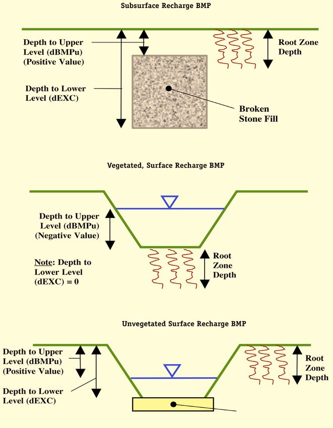
The BMP Calculations worksheet can analyze a recharge BMP located either on grade or constructed
below grade through excavation. An excavated BMP can be either a surface or subsurface BMP. The specific
type of BMP is described in the BMP Calculations worksheet through its effective depth (dBMP) and two
additional vertical distances. The first is the vertical distance from the vegetated ground surface to the
maximum water surface level in the BMP (variable dBMPu in Cell C7). This value is positive if the
maximum level is below the vegetated ground surface and negative if above the vegetated ground surface.
The second is the vertical distance from the vegetated ground surface to the bottom of the BMP (variable
dEXC in Cell C8). For example, if the top of a 36-inch deep stone-filled infiltration trench is located 24
inches below ground level, dBMPu would be 24 inches and dEXC would be 60 inches (i.e., dBMPu plus the
36-inch actual depth of the trench). It should be noted, however, that since the trench is filled with gravel
with a certain void ratio, the BMP’s effective depth (dBMP) would be 36 inches times that void ratio. Using
the dBMPu and dEXC variables, virtually all types of recharge BMPs can be specified, including “above the
surface,” “semi-buried,” and “completely buried” BMPs. See Figure 6-4 below and the NJGRS User’s Guide
for more information.
New Jersey Stormwater Best Management Practices Manual • Chapter 6: Groundwater Recharge • April 2004 • Page 6-12Figure 6-4: Examples of Depths to Upper (dBMPu) and Lower (dEXC) Levels of Recharge BMP
Sand Bottom
New Jersey Stormwater Best Management Practices Manual • Chapter 6: Groundwater Recharge • April 2004 • Page 6-13In using the BMP Calculations worksheet, it is important to note that, by default, the NJGRS takes the
values from the Annual Recharge worksheet for the Post-Development Recharge Deficit Volume (Cell K24)
and the Total Impervious Area (Cell M23) and specifies them as initial values on the BMP Calculations
worksheet for the Post-Development Deficit Recharge (variable Vdef in Cell C14) and Post-Development
Impervious Area (variable Aimp in Cell C15). This allows solution of the site’s total recharge deficit by a
single groundwater recharge BMP that will receive runoff from a developed site’s entire impervious area (if
specified as impervious land segments). However, in many instances, the single groundwater recharge BMP
will receive runoff from only a portion of the site’s impervious area (e.g., only roof runoff). In such cases,
the user must specify the exact size of Aimp (impervious area to the BMP) in Cell C15. Failure to do this for
such BMPs will result in an overestimation of the amount of runoff captured by the BMP and erroneous
BMP dimensions and/or recharge amounts.
At other sites, it may be necessary or desirable to utilize more than one groundwater recharge BMP to
meet the site’s recharge requirements. In such cases, each BMP will not only receive runoff from a portion of
the site’s impervious surface, but each will also seek to provide only a portion of the site’s total recharge
deficit. In such cases, the user must specify both the exact Aimp and Vdef (Post-Development Deficit) for
each BMP in Cells C14 and 15 of the BMP Calculations worksheet.. In such cases, the user must also use a
separate NJGRS spreadsheet for each BMP. Using multiple copies of the BMP Calculations worksheet within a single
spreadsheet can yield erroneous results.
In addition, computational problems can occur if, in designing a recharge BMP, the user selects either an
initial BMP surface area (ABMP) or effective depth (dBMP) that is drastically different than the actual value
needed to meet the required recharge deficit. If this occurs, the NJGRS may not be able to compute the
correct value and will, instead, display excessive large answers or divide by zero messages. If this occurs, the
user should adjust the initial value to one that more closely approximates the final answer and rerun the
worksheet.
The BMP Calculations worksheet will also present various characteristics of the recharge BMP, including
its effectiveness in converting runoff to infiltrated water and then recharged groundwater. See the NJGRS
User’s Guide presented at the end of this chapter for more information.
BMP Calculation Messages
The BMP Calculations worksheet provides three important messages to check the validity of the computed
results. The Volume Balance message (Cell J11) is a check of the Annual BMP Recharge Volume in Cell G14
against the Post-Development Deficit Recharge (variable Vdef in Cell C14). If these values are equal, the
problem is solved successfully and the message in this section will read “OK.” However, if the BMP’s annual
recharge volume does not equal Vdef, the message instructs the user to continue to solve the problem. This
may also occur if the user changes any of the BMP design parameters and forgets to solve the problem by
clicking on any of the two solve buttons.
The dBMP Check message (Cell J12) checks the validity of the value inputted for the dBMP, the BMP’s
effective depth in Cell C6. If this value is greater than the difference between the depths to the BMP’s upper
and lower surfaces (variables dBMPu and dEXC in Cells C7 and C8, a warning message is issued telling the
user to adjust dBMP. dEXC Check (Cell J13) is the third message. It checks the validity of dEXC to ensure it
is larger than dBMPu. If it is not, a message will appear instructing the user to make dEXC larger than
dBMPu.
Below these messages is a report on the location of the BMP as specified by the user in Cell C9 (variable
segBMP). If the user has entered a valid segment number for segBMP, the message will read “OK.” If the
user enters a zero for segBMP, the message will read “Location is selected as distributed or undetermined.”
However, if the user enters a land segment number that was not previously defined in the Annual Recharge
New Jersey Stormwater Best Management Practices Manual • Chapter 6: Groundwater Recharge • April 2004 • Page 6-14worksheet under Post-Developed Conditions, the message will say: “Land Segment Number Selected for
BMP is not Defined.” The user should then make appropriate corrections to segBMP.
See the NJGRS User’s Guide for more information regarding calculation check messages and warnings.
Additional Information
In addition to the above, the following important features and characteristics of the NJGRS should be noted:
1. The NJGRS gives the user the opportunity to specify what percentage of a development site’s annual
groundwater recharge deficit must be retained (Cell K23 of the Annual Recharge worksheet).
However, it should be noted that the program’s default value is 100 percent which, as noted above,
is the amount required by the NJDEP Stormwater Management Rules.
2. The pre- and post-development average annual recharge at a development site is a function, in part,
of the municipality in which the site is located. Therefore, changing the name of the municipality in
Cell C3 of the Annual Recharge worksheet will change both the pre- and post-development recharge
volumes. Similarly, if the user wishes to analyze a site in a different municipality, the new
municipality’s name must be entered through the drop-down list in Cell C3 in order to accurately
compute pre-and post-development recharge amounts.
3. In Cell K6 of the BMP Calculations worksheet, the NJGRS will display the “Inches of Rainfall to
Capture.” This value is also displayed graphically in Chart 1 of the NJGRS along with other pertinent
BMP performance information. This value specifies the minimum depth of rainfall over the BMP’s
impervious drainage area that must be collected to meet the development site’s average annual
recharge deficit. It is also the maximum event rainfall that the BMP can store without overflowing
and, as such, it is equal to the BMP’s Recharge Design Storm depth described previously in
“Theoretical Basis of Calculations.” This design storm depth is important, as it can be used to
estimate the resultant groundwater recharge design storm runoff from a development site with
groundwater recharge BMPs. See Examples 4, 5 and 6 in Chapter 5 for more details on this
procedure.
4. At the time of the NJGRS’ development, all soil series mapped in New Jersey were included in its
databases. Nevertheless, instances may arise where a soil series identified at a land development site
has not been included. In such instances, the user should select a similar soil series from the
program’s database. In doing so, the following criteria should be utilized, generally in the order
presented:
• Select a NJGRS soil series within the same Hydrologic Soil Group (HSG) as the site soil.
• Within the same HSG, select an NJGRS soil series with similar textural characteristics and
classification as the soil.
• If the site soil includes a fragipan, bedrock, or other restrictive layer below its surface, select
an NJGRS soil series with a similar restrictive depth.
• If more than one choice of NJGRS soil series appears reasonable, the user may then analyze
and compare the annual groundwater recharge amounts for each using the NJGRS program to
help make a final selection.
New Jersey Stormwater Best Management Practices Manual • Chapter 6: Groundwater Recharge • April 2004 • Page 6-15Recharge BMP Design Guidelines
In general, the design of a groundwater recharge BMP to offset a development site’s groundwater recharge
deficit should follow the standards and guidelines for dry wells, infiltration basins, and pervious paving
systems with storage beds presented in Chapter 9. This includes utilizing soil permeability data obtained
from tests such as those contained in Standards for Individual Subsurface Sewage Disposal Systems at
N.J.A.C. 7:9A at the site of the proposed recharge BMP. In addition, the recharge BMP design must be based
on the following guidelines:
1. Computation of the pre- and post-development annual groundwater recharge rate and the annual
recharge deficit should be based upon the New Jersey Geological Survey Report GSR-32 A Method
For Evaluating Ground-Water-Recharge Areas in New Jersey, which is incorporated into the
NJGRS.
2. Only the directly connected impervious portions of a recharge BMP’s drainage area can be used to
compute runoff to the BMP. In the NJGRS, the input parameter Aimp, which is the size of the
recharge BMP’s drainage area, must represent only directly connected impervious surfaces. This is
particularly relevant for infiltration basins and pervious paving systems used for groundwater
recharge that may also have pervious and unconnected impervious areas draining to them.
3. Runoff collected from roofs and other above-grade surfaces can be directly conveyed to a recharge
BMP. However, roof gutter guards and/or sumps or traps equipped with clean-outs should be
included upstream of the recharge BMP wherever possible to minimize the amount of sediment or
other solids that can enter the BMP.
4. Runoff collected from parking lots, driveway, roads, and other on-grade impervious surfaces and
conveyed to a subsurface recharge BMP must be pretreated to remove 80 percent of TSS in order
to prevent the loss of storage volume and/or recharge capacity due to sedimentation and clogging.
Exceptions may be possible for patios, tennis courts, and similar on-grade impervious surfaces
with minimal TSS loadings on case-by-case basis. Such treatment can also be used to meet the
site’s overall TSS removal requirements. In addition, all on-grade drainage areas to a subsurface
recharge BMP should consist only of impervious surfaces. Exceptions to this requirement may
include roadway right-of-ways, vegetated parking lot medians, planting and landscape beds, and
other pervious surfaces provided that they comprise only a small percentage of the total drainage
area and will not generate an excessive amount of TSS or other material that might adversely
impact the subsurface recharge BMP. As noted above, if such areas are part of the actual drainage
area, they must not be included in the drainage area size (variable Aimp) used in the NJGRS’ BMP
Calculations worksheet to design the recharge BMP.
In addition, it should be noted that, since the BMP Calculations Worksheet assumes that all
runoff from a recharge BMP’s impervious drainage area will be delivered to the BMP, it cannot
directly account for runoff losses incurred at a pretreatment measure located between the drainage
area and the recharge BMP. If such losses will occur due to the selected pretreatment measure,
appropriate compensating adjustments may be attempted in the BMP Calculations Worksheet
input data or alternative BMP calculation techniques utilized.
5. In general, County Soil Surveys prepared by the U.S. Department of Agriculture and the State Soil
Conservation Committee can be used to obtain the soil series data required for the determination
of annual land development site recharge rates and deficits and the dimensions of recharge BMPs
using the NJGRS program. However, site soil tests will be required at the actual location of a
proposed recharge BMP in order to confirm the BMP’s ability to function properly without failure.
Such tests should include a determination of the textural classification and permeability of the soil
New Jersey Stormwater Best Management Practices Manual • Chapter 6: Groundwater Recharge • April 2004 • Page 6-16at the bottom of the proposed recharge BMP. As noted above, permeability testing can be
conducted in accordance with Standards for Individual Subsurface Sewage Disposal Systems at
N.J.A.C. 7:9A.
Depending upon the type, location, use, and maximum design storm of the selected recharge
BMP, minimum design soil permeability rates will vary from 0.2 to 0.5 inches per hour and that a
factor of safety of 2 must be applied when converting a tested permeability rate to a design rate. In
addition, the soil permeability rate must allow the recharge BMP to fully drain its maximum
design storm runoff volume within 72 hours. Recharge BMP locations that fail to meet these two
requirements should be rejected and alternative onsite locations selected. A groundwater recharge
waiver may be sought from the applicable reviewing agencies if suitable permeability rates cannot
be found at any recharge BMP locations on the development site.
See Chapter 9 for details on structural best management practices that can be used as recharge
BMPs, including minimum design permeability rates. Such BMPs include dry wells (Chapter 9.3),
infiltration basins (Chapter 9.5), and certain types of pervious paving systems (Chapter 9.7).
6. The results of the BMP site soil testing should be compared with the County Soil Survey data used
in the NJGRS’ annual recharge and BMP design computations to ensure reasonable data
consistency. If significant differences exist between the BMP site soil test results and the County
Soil Survey data, additional development site soil tests are recommended to determine and
evaluate the extent of the data inconsistency and the need for revised annual recharge and BMP
design computations based upon the site soil test results. All significant inconsistencies should be
discussed with the local Soil Conservation District prior to proceeding with such redesign to help
ensure that the site soil data is accurate. It should also be noted that significant inconsistencies
between development site soil tests and the County Soil Survey may warrant revisions to the site’s
stormwater quality and quantity storm computations.
7. The development site areas that extensive site soil testing determine to have permeability rates less
than 0.2 inches per hour may be considered to belong to Hydrologic Soil Group D in the NJGRS
program. For such areas, the user may use any HSG D soil in the NJGRS soil series database to
define such site areas in the NJGRS’ Annual Recharge worksheet. In accordance with the
assumptions of both the NJGRS program and N.J. Geological Survey’s Geological Survey Report
GSR-32: A Method for Evaluating Ground Water Recharge Areas in New Jersey, such areas will
not produce any groundwater recharge. Once again, the assignment of HSG D to any development
site areas should be discussed with the local Soil Conservation District prior to proceeding to help
ensure that the site soil data is accurate.
New Jersey Stormwater Best Management Practices Manual • Chapter 6: Groundwater Recharge • April 2004 • Page 6-17The New Jersey Groundwater Recharge Spreadsheet (NJGRS)
User’s Guide
Version 2.0 – November 2003
There are two computational worksheets in the NJGRS spreadsheet:
• Annual Recharge: This worksheet, which resides on the first page of the spreadsheet, is used to
estimate the annual groundwater recharge volumes that occur naturally under the Pre-Developed
and Post-Developed Conditions. Based on the value of “percent of Pre-Developed Annual Recharge to
Preserve” that the user provides (NJDEP currently requires 100 percent for this parameter), the
worksheet calculates the “Post-Development Annual Recharge Deficit” in cubic feet. This is the
annual recharge volume that must be provided by one or more groundwater recharge BMPs.
• BMP Calculations: This worksheet, which resides on the second page of the spreadsheet, is used
to design the required size and configuration of one or more groundwater recharge BMPs to satisfy
the “Post-Development Annual Recharge Deficit” calculated in the Annual Recharge worksheet.
NOTE: Only the above worksheets in the NJ Groundwater Recharge Spreadsheet are for user input. Charts 1
through 3 can be viewed for visual inspection of the results. Other worksheets in the spreadsheet are either for
internal calculations or contain the databases used by calculations. The user should refrain from changing
anything in these worksheets.
Part 1: Using the Annual Recharge Worksheet
Figure 1: Screen Capture Showing the Annual Recharge Worksheet
New Jersey Stormwater Best Management Practices Manual • Chapter 6: Groundwater Recharge • April 2004 • Page 6-18• Figure 1 is a screen capture from an example application of the Annual Recharge Worksheet. All
user-input cells are tan colored. All gray colored cells are used to show calculation results or
internal validity checks and must not be changed by the user. The three cells at the upper right
corner of the sheet are where the user can input project information. These inputs are optional,
but they can help in identifying the project and the alternative being analyzed.
• As the first step, the user must select the project’s municipality. Click once on the municipality
cell (Cell C3) and select the project’s county and municipality from the drop-down list of all New
Jersey municipalities, which is arranged by county in alphabetical order. Once the user has
selected a municipality, the values of average annual precipitation and the climate factor are set for
that municipality in the two cells to the immediate right of the municipality’s name (Cells D3 and
E3).
• The next step is to provide information about pre-developed site conditions. The first column is
the land segment number (Cells A6 to A20). Up to 15 different land segments can be inputted in
this table.
NOTE: If you have more than 15 different land segments, try to combine similar segments together or subdivide
your area into smaller areas not consisting of more than 15 land segments.
• For each land segment, first enter the area in acres. Then select an appropriate TR-55 land cover
description from the drop-down list of standard NRCS land cover descriptions. Finally, select the
segments soil series from the drop-down list. Note that, as soon as the area for a segment is
entered, the entries for other columns become visible and selectable. Start from the top of table
and proceed downward. Do not leave blank rows (with zero area) between land segment entries;
rows with zero areas will not be displayed or used in calculations.
NOTE: Once you click on any of these cells a pop-up help message will appear to briefly tell you about the
required input for that cell.
• As can be seen from the list of available TR-55 land cover descriptions in the drop-down list, there
may be more than one way to describe the pre-developed land cover at a project site, particularly
when that cover is a mixture of pervious and impervious surfaces such as a single family
residential development. For assistance, see the guidelines in the New Jersey Groundwater
Recharge Spreadsheet (NJGRS) section of Chapter 6 for selecting segment limits and land cover
descriptions. Finally, it should be noted that, under the Pre-Developed Conditions section, it is
not necessary to specify the soil series for site segments with impervious land cover, since the
natural recharge in these segments is set at zero.
NOTE: If the soil you select for a land segment is hydric, recharge will be set to zero for that segment.
• Once the user has completed inputting all land covers in the table for the Pre-Developed
Conditions, check the total area in acres (Cell B21) to ensure that the total project area is correct.
The last two columns of this table show the naturally occurring average annual recharge amount
as a depth (in inches over the segment area) and a volume (in cubic feet) for each land segment.
At the bottom of these columns (Cells E22 and F22), the average recharge depth (in inches) and
the total annual recharge volume (in cubic feet) over the total area under Pre-Developed
Conditions is given. This number is later used in the calculation of any post-development
recharge deficit.
• The above procedure can also be used to enter the required data for the post-developed site
conditions. In doing so, please note the following additional requirements:
1. To correctly compute the performance and/or required size of a proposed groundwater
recharge BMP, the area in which the BMP will be located must be entered as a separate site
New Jersey Stormwater Best Management Practices Manual • Chapter 6: Groundwater Recharge • April 2004 • Page 6-19segment with its associated soil series. The number of this segment must also be specified on
the BMP Calculations spreadsheet (see below).
2. As noted above, it is normally not necessary to specify the soil series within an impervious
site segment. However, the soil series of the impervious segment must be specified if a
proposed groundwater recharge BMP will be located within or below it (e.g., a stone-filled
infiltration trench below a parking lot). As noted in 1 above, the soil series is necessary in
order to accurately compute the performance and/or required size of the proposed BMP.
• Finally, as noted above, see the guidelines in the New Jersey Groundwater Recharge Spreadsheet
(NJGRS) section of Chapter 6 for further assistance in selecting appropriate segment limits and
TR-55 land cover descriptions for post-developed site conditions.
NOTE: Soil series selected for the impervious areas in the Post-Developed Conditions table are automatically
displayed in orange, signifying that they have no effect on the site’s natural annual recharge calculation (i.e.,
recharge set to zero for all land segments classified as “Impervious areas” regardless of the soil type), but that
they can affect the artificial annual recharge volume of any groundwater recharge BMP set below them.
• Once the user has completed inputting all land segment information in the table for the Post-
Developed Conditions, once again check the total project area (Cell I21) to ensure that the total
post-development project area is correct.
NOTE: If the total area in the Post-Developed Conditions is different from the total area in the Pre-Developed
Conditions, a warning message will appear to the right of the total Post-Developed project area (Cell J21).
• As an additional check, the total impervious area (in square feet) under Post-Developed conditions
will be shown at the bottom right of this table (Cell M23). Please note that this value reflects only
those impervious areas specified as separate project segments and does not include any
impervious areas within those segments specified by the standard TR-55 residential or urban land
descriptions. The last two columns of this table show the naturally occurring average annual
recharge depth (in inches) and volume (in cubic feet) for each land segment. At the bottom of
these columns (Cells L22 and M22), the average recharge depth (in inches) and the total annual
recharge volume (in cubic feet) over the total area under Post-Developed Conditions is given. This
number is also used later in the calculation of any Post-Development recharge deficit.
• Immediately below the Post-Developed Conditions table is the Annual Recharge Requirements
Calculation section. The user needs to input the “percent of Pre-Developed Annual Recharge to
Preserve” (Cell K23) to set the percentage of the recharge under Pre-Developed Conditions that
must be maintained under the Post-Developed Conditions. The NJDEP Stormwater Management
Rules at N.J.A.C. 7:8 currently requires this value to be 100 percent, which is the spreadsheet’s
default value. The spreadsheet then computes the difference between the total annual recharge
volumes for Pre- and Post-Developed Conditions and multiplies it by the “percent of Pre-
Developed Annual Recharge to Preserve.” The resulting value is shown as the “Post-Development
Annual Recharge Deficit” in the worksheet (Cell K24). This amount is 103,435 cubic feet in the
case of the example in Figure 1. This is the volume of groundwater recharge that must be
artificially recharged under Post-Developed Conditions annually through groundwater recharge
BMPs.
• The “Recharge Efficiency Parameter Calculations” table shown below the “Post-Development
Annual Recharge Deficit” show the parameters calculated by this worksheet that are later used in
the BMP Calculations worksheet.
NOTE: The Appendix to this guide provides the basic equations and defines the variables used in Recharge
Efficiency Parameter Calculations.
New Jersey Stormwater Best Management Practices Manual • Chapter 6: Groundwater Recharge • April 2004 • Page 6-20You can also read