Leith Walk/Halmyre Street Place Brief - site assessment background paper (March 2020) - Edinburgh Council ...
←
→
Page content transcription
If your browser does not render page correctly, please read the page content below
Leith Walk/Halmyre Street Place Brief – site assessment background paper (March 2020)
This paper collates general and site specific feedback from specialist officers and key agencies.

Site Description
The site is an area of backland which sits to the east of Leith Walk. Much of the site is currently derelict and vacant.
There are three main landowners/promoters of this land.

The council owns the former depot site to the to the south (area 2). This land has mostly been cleared of the
former buildings. To the west of this land is a recently restored C listed building (165 Leith Walk) which contains
Local Authority offices.

There are proposals for a substation to serve the tram extension along Leith Walk to be located in the far western
corner of Area 2 close to the southern boundary.

Area 1 is being promoted for development. This land contains former government offices which are temporarily
being used as a gym & wellness centre (Projekt 42). The understanding is that this organisation will be rehoused on
the site in new premises and the office building demolished. The land also contains a car park which serves two
NHS offices (Allander House and Inchkeith House) which are located along Leith Walk. Any future development on
the site needs to include some parking for these offices. Area 2 has a number of connections through to the streets
around the site (Leith Walk, Halmyre Street and Manderston Street), three of these are currently suitable for
occasional vehicular access, one is pedestrian access only. The connection to Halmyre Street is likely to be the main
vehicular access into the site, although vehicular access to a new substation for the Tram may be required from
Leith Walk.

Area 3 is a bingo hall. This is a large building occupying a significant area of the site, the building incorporates parts
of the former mill building which was on the site. There are no current proposals to redevelop the building as it is
currently well used and provides an important social function in the area. However, there is the potential that the
building may become available in the future and proposals for the site should be designed to take that possibility
into account.

Leith Walk encloses the site to the west. Buildings along this boundary range between 1 and 4 storeys in height and
are built using a range of architectural styles and materials. These buildings have commercial/retail uses on the
ground floor and many have residential uses at higher levels.

To the north of the site is Manderston Street. Along this boundary runs a series of red sandstone former railway
arches most of which have been enclosed and are being used for small workshops and motor trade businesses. The
entrance to the bingo hall is through one of these arches. The bingo hall building itself is the tallest building on the
site extending to the equivalent of around 6 storeys in height. One arch along Manderston Street, (20 Manderston
Street), has been left open and could provide a pedestrian access to the site. The bingo hall and Projekt 42 have
rights of access through this arch to the rear of their properties. The owner of the arch needs vehicular access
through the arch for their business. Planning permission has recently been granted allowing for the enclosure of
the archway – leaving a small pend as access. The archway at 20 Manderston Street should provide a cycle or
pedestrian route if possible with vehicular access for the businesses if required.

There have been proposals in the past to create a route/park along the top of the railway arches – similar to the
highline in New York. These have not been progressed but proposals should consider that the top of the railway
arches could be utilised in the future.

East of the site is Halmyre Street and Thorntree Street which are fronted by traditional 4 storey sandstone
tenement buildings and early 21st century 4 storey care home buildings. The edge of the site along this boundary is
made up of car parks and gardens to these buildings. Direct access from the site into Thorntree Street cannot
currently be gained however there may be potential to form a link if the bingo hall is developed in the future.

To the south east of the site are a several late 20th century 4 storey residential apartment blocks, with associated
gardens and car parks. To the south west the site faces onto the backs of 3 storey, early 19th century tenement
buildings along Smiths Place which are listed. These buildings are mainly residential but do include some offices and
conversion of one building to a hotel is underway.
There is a distinct drop in level running east/west across the site (the level difference increasing towards the east).
The lower land is to the north. Addressing the levels across the site is a key issue which will need to be addressed
by new development.

Key points for place brief:

The change in levels across the site needs to be carefully considered and a co-ordinated approach adopted.

The operation of the workshops and garages in the railway arches along Manderston Street should be protected
from disruption and the potential of future complaints.

The opportunity for a connection to be made to Thorntree Street in the future should be protected.

A substation for the tram is to be developed in the south western corner of the site, this will require vehicular
access. The substation is likely to be clearly visible from Leith Walk, efforts must be made to minimise the visual
impact of the substation from Leith Walk and on other future development on the site.

Development proposals should take into account the potential for the redevelopment of the bingo hall site.

Proposals should take into account the potential for future development on the top of the railway arches.

A cycle or pedestrian route through the archway at 20 Manderston Street is desirable – with vehicular access for
the businesses if required.

The boundaries around the site need to be carefully addressed:

    -   To the north the relationship to the workshops and the bingo hall
    -   To the east development should allow for connection to Thorntree Street and address the carpark to the
        Bield care home.
    -   To the far south the development should address the apartments along Halmyre Street.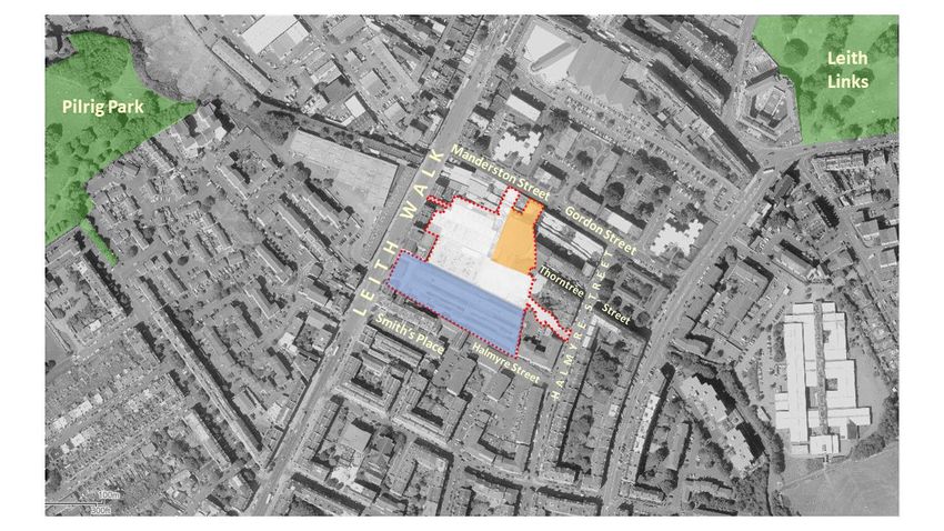
- To the south west the development needs to carefully address the rear of the listed buildings along Smith’s
Place.
- To the west the development is faced by the rear of the buildings along Leith Walk and includes the carpark
for the NHS buildings.
Urban analysis
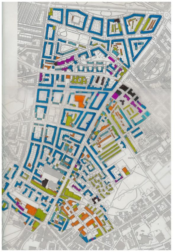
The site is located to the east of Leith Walk, in a distinctive area between Leith Walk and Easter Road.
Block pattern
around the site
Aerial view showing the distinctive
urban grain and block structure of
the area around the site
This area is predominantly made up of perimeter blocks of 4 storey tenement buildings which are built hard to the
street. The smaller of these blocks are infilled with rear gardens. The larger blocks incorporate internal
development in several ways as analysed in the table below. As a rule, the development within a block is
subservient to the scale of the perimeter of the block (the bingo hall building on the Leith Walk/Halmyre Street site
is a rare exception to this and therefore should not be taken as a precedent). Traditionally the development in the
centre of these blocks was a mix of industrial/commercial and community uses with some small scale residential
buildings. More recent developments have tended towards more residential uses including student housing.
To the west of Leith Walk the pattern and form of development has traditionally been less consistent, with a range
of building heights and urban form having been developed in the area. Over the last 40 years the redevelopment of
former industrial and railway sites have delivered a range of built forms from low density suburban style housing to
high rise, high density apartment blocks more recently.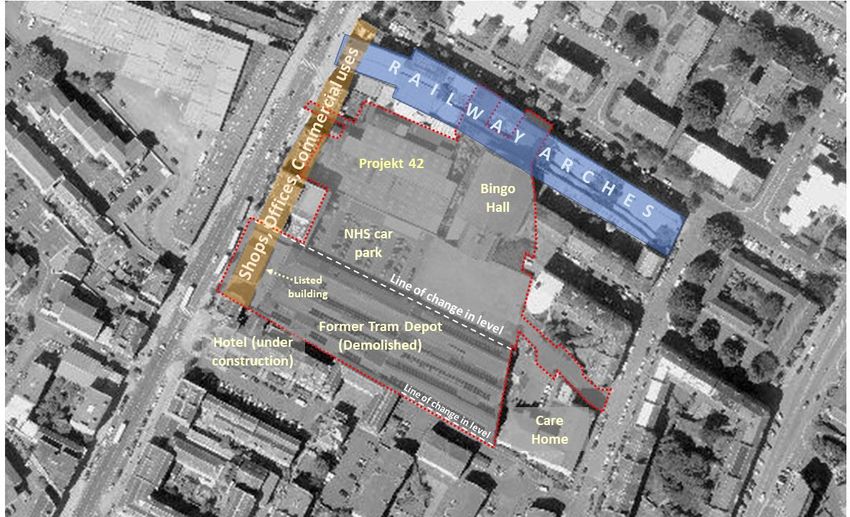
Block Type                Example                     Street Pattern   Building Heights:

Traditional mews          Brunswick Street Lane
lane within the           – mews development is
block – lane with         subservient in scale to
small 1-2 storey          the buildings along the
buildings often           perimeter of the block.
incorporating
workshops and small
industrial uses
alongside some
residential uses.

Street pierces the        Jameson Place – Lined
block – cul-de-sac        with traditional 4 storey
street usually faced      tenements and 3-4
with buildings of a       storey early 21st century
similar scale to the      apartment block to the
perimeter                 east. The scale of these
                          buildings matches the
                          perimeter.

Large footprint           Dalmeny Street – the
building –                large footprint former
The perimeter includes    Drill Hall building
a large footprint         extends into the centre
building which extends    of the block. More
into the block            recently 1-3 storey
                          apartments have been
                          built to the rear of the
                          Drill Hall.
Individual buildings      Montgomery Street –
placed within the         Two 3-4 storey student
block – one or more       accommodation
individual buildings      buildings are located
located within the lock   within the block. These
(not forming a street     are 3 - 4 storey blocks
or lane)                  similar in scale to the
                          perimeter but they are
                          subservient because the
                          land in the centre of the
                          block is lower and
                          because of lower storey
                          heights in the new
                          buildings.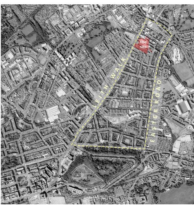
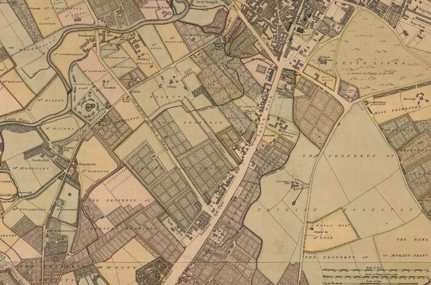
The site was one of the first areas developed along Leith Walk and forms part of the largest block in the area.

                                                                                 SITE

Extract of map from 1804 (Reproduced with the permission of the National Library of Scotland)

Extract from 1935 map showing the site             Current height plan of the
showing industrial and railway uses                site and surrounding block
(Reproduced with the permission of the
National Library of Scotland)

This block has traditionally had a more varied perimeter structure to others in the surrounding area due to the mix
of industrial and transport uses that were on the site, and it is in an area of transition between predominantly
residential areas to the south to predominantly industrial areas in the north and west. Both areas have always
included a wide mix of uses although the balance of these uses has changed over time as more residential replaces
industrial uses in the area.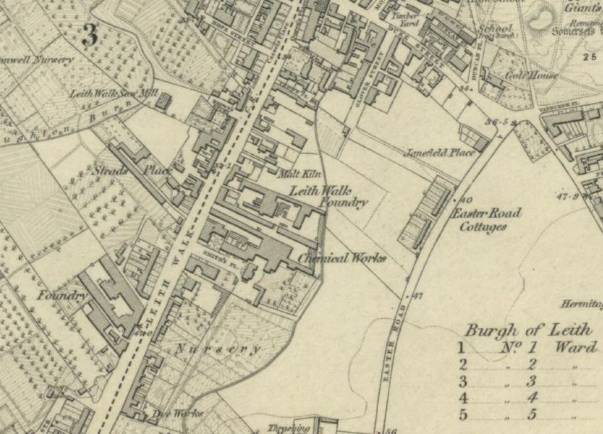
The bingo hall was the highest building built in the area to the east of Leith Walk until some recent developments
to the rear of Albert Street. The building utilised part of a former engineering works which form elements of the
western and southern elevations. The large pitched roof and pale pink brick effectively hide the bulk and height of
the building, so it does not stand out in the townscape when viewed from afar (see image below) – unlike some of
the high blocks which are clad in light finishes and have flat roofs which are located further north and west in Leith.
Given that it is an exception in the area rather than the norm, the height of the bingo hall should not be taken as a
precedent for the height of new development on the site.
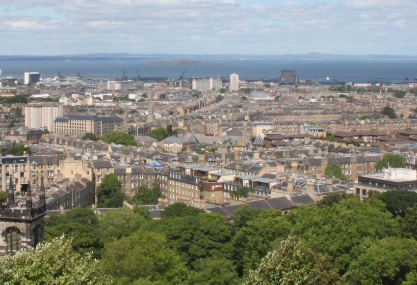
Bingo Hall
View north from Calton Hill
Looking across Leith from Calton Hill the overall uniformity of height in this area is apparent. Any future
development should not exceed the height of a standard 4 storey Victorian tenement in the area (as exampled by
the tenements along Thorntree Street). This reflects conclusions in the Statement of Urban Design Principles for the
site which were approved by planning committee in November 2004.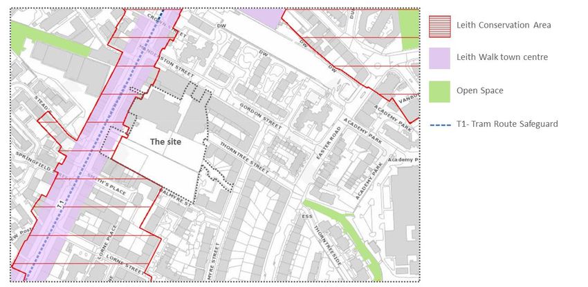
Diagram analysing
       building heights along
       Leith Walk and
       between Leith Walk
       and Easter Road.

                                                                                                       .

Key points for place brief:

Any new development on this site should not exceed the height of the Victorian tenements along Thorntree Street.

The bingo hall is not to be considered a precedent for the height of future development on the site.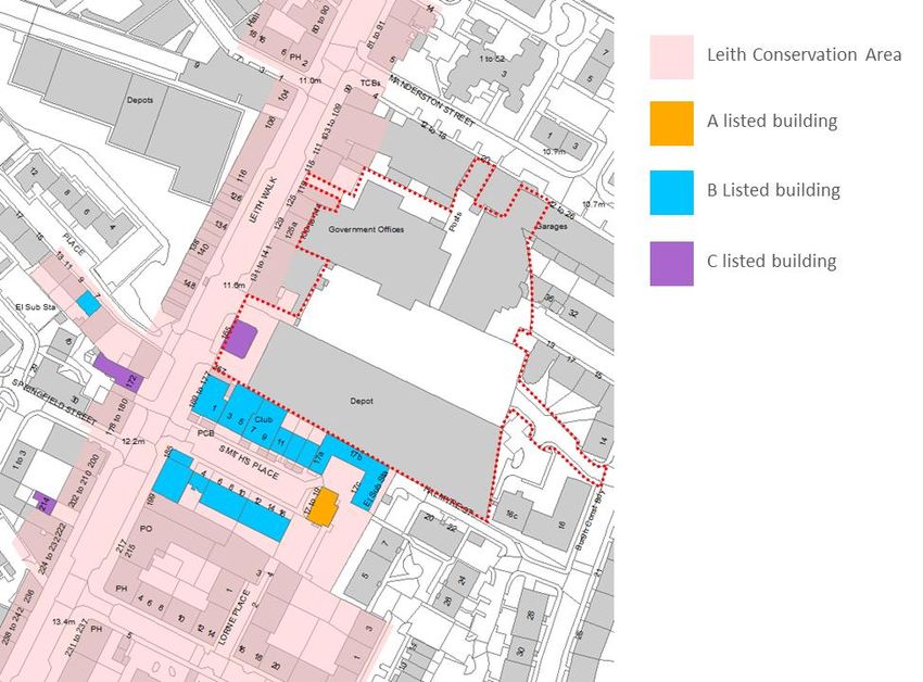
Planning policy context

                                                                               Extract from the
                                                                               Edinburgh Local
                                                                               Development Plan 2016

Parts of the site (along Leith Walk) are within Leith Conservation area. Leith Walk is also identified as
being part of the designated Leith Walk town centre. Proposal T1 runs adjacent to the site – this proposal
is a safeguarding for a tram route. Delivery of the tram extension along Leith Walk is being progressed.
Recent Planning history:
19/05009/FUL: 18 Manderston Street (Approved)
Enclose both open ends of open industrial unit, including formation of a pend to access rear.

19/00415/PAN: Land To East Of 139 Leith Walk (Approved)
Refurbishment of the existing building, or potential demolition for sui generis flatted accommodation
(residential apartments), class 7 hotel/ serviced apartments, student accommodation and commercial
uses (class 4 business use) and class 11 (gym) with associated footpaths, roads, landscaping and potential
reconfiguration of existing car park.
The PAN was considered at the Council’s Development Management Sub-Committee on 20 March 2019.
Committee Members raised the following issues which they expect to be taken into account in
progressing this proposal:

   •   The layout must be co-ordinated with the adjacent tram depot site and include linkages and clear
       public routes;
   •   The heritage of the area requires to be evaluated;
   •   Permeability through site is required, in both north – south and east – west directions, with clear
       public routes provided;
   •   The development needs to comply with the Council’s sustainability requirements;
•   The need to take account of the deficiency of open space in the surrounding area, in the proposed
       layout;
   •   The need to ensure that the proposals for student accommodation comply with Student Housing
       guidance and to demonstrate how such accommodation will be appropriately managed;
   •   Need to pay due regard to impacts of student housing on local services and amenities;
   •   Provision for safeguarding of railway arches to be demonstrated;
   •   The need for small business space must be taken into account (regard should be taken of relevant
       concerns relating to Steeds Place application);
   •   The proposals should demonstrate how the existing railway arches would be safeguarded;
   •   The potential for providing a cycle/ walking route above railway arches to be considered;
   •   Consideration should be given to a zero car parking development;
   •   Meaningful consultation is required.

18/03674/FUL: 165 Leith Walk (Implemented)
Temporary Planning Permission for change of use to community uses including class 1, class 3 and class
11 Skate Park (as amended).
Land immediately to the rear of the listed building at 165 Leith Walk is being used on a temporary basis
for pop up events. There are a number of cabins/kiosks on the site along with a wooden half pipe for
skateboarders.

17/03539/FUL: Proposal for a single storey building for a community gym and wellness centre (approved)
to the rear of the bingo hall.
Approval for a new centre for project 42 – not implemented. Projeckt 42 now to be accommodated as
part of proposed development on area 2.

Key themes for place brief:
Safeguarding of neighbouring amenity and satisfactory provision for future occupiers.
Daylight, overshadowing and privacy information will be required to demonstrate that the proposals
would provide suitable amenity standards for future residents and the safeguarding of the amenity of
neighbouring properties, particularly those in close proximity to the site boundary.
A co-ordinated approach is required.

   •   Opportunities for forming connections and linkages across the wider site, respecting key desire
       lines for walking and cycling;
   •   Managing variations in ground level across adjacent sites;
   •   Providing efficient vehicular access, minimising the impact of cars; and
   •   Delivering acceptable levels of fit-for – purpose private open space, greenspace and overall
       amenity standards across both sites.
Built Heritage and Archaeology
Built Heritage
The interior of the bingo hall is impressive – this building is of merit although it is not listed.
The conservation area includes the frontage of the site along Leith Walk.
The setting of the listed building (165a Leith Walk) is important but not a big issue. The listed building has always
been free from adjacent buildings with space around it – this should remain the position.
The townscape in this area is a mix of different arrangements, heights and ages.
The site adjoins the rear of a number of B listed buildings along Smiths Place – this edge of the development needs
to be carefully considered.
Built Heritage Designations
on and around the site
Archaeology
This development site is of archaeological significance both in terms of buried and upstanding buildings relating
(principally) to the Industrial development of Leith and Edinburgh from the 18th century.
Historically the site lies on the eastern side of the medieval road (Leith Walk) linking Edinburgh with its port of
Leith, though outwith the port’s pre 18th century limits. Although the site may contain evidence for siege works
relating the 1559-60 Siege of Leith, it is likely to have remained agricultural ground until the establishment of
Andersons Iron Foundry in the site in the second half of the 18th century (see the attached image from Ainslie 1804
map). The 19th century saw the industrialisation of the site with the Leith Walk Foundry and also the Caledonia Mill.The last significant upstanding element of this important 19th century industrial heritage is the Mecca Bingo Hall occupying Area 3. Although not listed this building in our opinion is of at least local historic and archaeological significance and an increasing rare survival of this heritage. As such in line with ENV9 and DES3 we would be recommending that the development brief looks at its retention and conversion. Towards this end a detailed building assessment must be undertaken as part of any further development of the site and certainly prior to the submission of any subsequent PAN’s and planning applications. Area2: contains the C-listed 165 Leith Walk former Tram/community building. This building must be retained within any future development proposals. Areas 1-3; recent minor archaeological work on the site has indicated that archaeological remains have survived across the area. However, these interventions have been very minor and it is essential that as part of any detailed master planning that an archaeological evaluation is undertaken across the site to determine the actual levels and significance of archaeological remains. The results of this work will allow us to assess what further mitigation will be required both in terms of excavation/recording/analysis/community engagement but significantly preservation in situ and interpretation which could material affect final development designs. Key themes for place brief: Impact on the character of the Leith Walk Conservation Area needs to be taken into account. No development should be built adjoining the C listed 165a Leith Walk building. The site boundary which runs along the rear of the listed buildings along Smith Place needs careful consideration. How the development relates to the north-eastern elevation of the former chemical works at 17 Smith’s Place is of particular importance. An archaeological evaluation would be required as part of masterplanning processes for the site. A detailed building assessment of the bingo hall would be required as part of any proposals for that building. Historic Environment – provision to be made for safeguarding the setting of the adjacent tram office, listed building, the railway arches and the character and appearance of the adjoining, Leith Walk Conservation Area.
Open space and Play

                                                                        Leith Links

       Pilrig Park

  Extract from the Edinburgh
  Open Space Audit 2016

The site is in an area which is between two large public parks which contain playspaces – Pilrig Park and Leith Links.
In the Edinburgh Open Space Audit 2016 Pilrig Park was classified as good quality while Leith Links was classified as
low quality. Edinburgh’s Open Space Standard 2021 says that all homes should be within 800m walking distance of
an accessible large greenspace of at least 2 hectares and a playspace of good standard. The site is within 500m of
both Pilrig Park and Leith Links.

Key themes for place brief:
Well designed and functional open space and public realm provision is required.
Sunlight to public realm needs to be taken into account.

Natural Heritage and access
This is a well linked area – especially paths heading west from the site – east-west links through the site are
important (links to Leith Academy)

Leith needs more green infrastructure.

This is a good site for the integration of blue/green infrastructure to provide a good example of blue green
infrastructure provision. Consider how to provide blue/green infrastructure on walls and roofs. Ideally looking for a
developer who would attempt to gain a ‘Building with Nature’ accreditation.

Key themes for place brief:
The integration of green and blue infrastructure should be a key feature of this development.
Ideally the proposal would gain a Building with Nature accreditation for good practice.
Townscape, Character and setting
Extract from the Leith conservation area appraisal – Leith Walk:
A hard continuous edge is given to the east by almost uniform and repetitive tenements. These continue to form
traditional perimeter blocks around common greens down the side streets. These are given life by the local
communities and the variety of goods and services on offer in ground floor premises.
The side streets to the east are mainly residential, but several include churches or a school and just to the edge of
the area are completely taken up by a park such as at Iona / Sloan Streets.
Although not within the Leith Conservation Area, the site abuts part of the conservation area fronting
onto Leith Walk. Building heights at this end of Leith Walk (including nearby Listed Buildings and those
within the Conservation Area) are relatively low - generally no more than 4 storeys. Using the ridge height
of the Bingo Hall as a precedent for height is unacceptable because its scale/massing is exceptional
relative to the surrounding urban grain.
Any future proposal would need to demonstrate through the use of a Townscape and Visual Impact
Assessment, the predicted visual impacts of the development on the surrounding townscape, including
Listed Buildings and the wider conservation area, and key views. This supporting information will be
expected to demonstrate how the assessment has been used to inform a sensitive design response
Need to link height and massing of development to the character of Leith and consider city views.
Roofscape is important as the site will be viewed from above – the use of pitch roofs vs flat roofs needs to be
carefully considered - there is the potential for flat roofs to incorporate solar panels.
Protected Views:
The site is in the viewcone of a number of key views:
• N09: Calton Hill monuments from north end of Constitution Street, Leith.
• N11b: Calton Hill, across to Hub spire
• S4b: Castle and Hub spire from Wester and Easter Craiglockhart Hills
• S13b: Castle and Hub spire from A70, Lanark Road, at S-W corner of Dovecot Park, Kingsknowe
• S14c: Castle and Hub spire from west side of Clovenstone Community Woodlands, near B701Key view N09: Calton Hill monuments
from north end of Constitution Street,
Leith
The methodology set out in the City of Edinburgh Skyline Study Oct 2010 has been applied to establish the
maximum height of building which could be accommodated on the site without impacting on the view. The Skyline
Calculation is below:
Key View N09 metres
Step 1 Insert level at A + 1.5 for eye level 6.5
Step 2 Insert level at BC 85.0
Height Difference 78.5
Step 3 Measure and insert distance A - BC 2850.0
Step 4 Measure and insert distance A - P 1250.0
(P = Proposal site)
Gradient of bottom of viewcone rising 1 in 36.3
Level in mAOD above site to bottom of
viewcone 40.9
The calculation shows that the bottom edge of the viewcone is at 40.9 mAOD over the site. The site itself is around
11.8m AOD (levels vary across the site), giving a building height of around 29m before development would impact
on viewcone N09.
Some other viewcones for key views include the site:
View N11b is from Leith Docks – the impact of development on the site will be reduced from this view point as a
change in approach to Leith Docks means that this viewpoint will not publicly accessible. The height that
development would need to be before it could impact on this viewpoint is slightly lower than N09 – at around 26m.Views S04b, S13b and S14c are all views taken from the south west of the city towards the castle. The site is in the
background (behind the castle) in the longer viewcone. Analysis shows that development on the site would have to
be over 50m tall before it would impact on any of these views.
Keyview S4b: Castle and Hub spire from
Wester and Easter Craiglockhart
HillsLeith
Key themes for place brief:
Design and layout, and scale of development, to be compatible with the surrounding townscape and to make a
positive contribution to the site’s surroundings.
Roofscape is important as the site will be viewed from above – the use of pitch roofs vs flat roofs needs to be
carefully considered - there is the potential for flat roofs to incorporate solar panels.
A Townscape and Visual Impact Assessment will be required.
Community services and facilities
There are a good range of community services and facilities including schools, healthcare, leisure
activities, retail and places of worship along Leith Walk and in the surrounding area. Projekt 42 is
currently located on the site and is due to be relocated into space within future development in area 2.
Paths, routes and roads
Tram extension to be developed along Leith Walk. A substation to serve the tram is to be provided on the
site to the south west. Vehicular access is required to the substation.
Sustainable Transport:
New tram and cycle infrastructure is to be delivered along Leith Walk – this will impact on cyclists and
vehicles ability to turn right onto and off Leith Walk. Various crossings (controlled and uncontrolled) willbe provided along the frontage between Smith’s Place and Manderston Street. The junction of
Manderston Street and Leith Walk will be signalised.
Connections between Leith Walk and Easter Road are minimal but Manderston Street/Gordon Street
provides one of these connections. Provision of an east/west route through the site is important. The
railway arch link to Manderston Street is also an important connection for cyclists as will link to a right
turn north at the junction with Leith Walk.
Connections to the east are important but given the access road onto Halmyre Street providing a cycle
link onto Halmyre Street to the south (where there is a change in level) is not considered particularly
important.
Provision of a connection onto Thorntree Street would be beneficial if it was possible.
Proposed controlled and uncontrolled crossing points along Leith Walk.
General Transportation comments:
• A full Transport Assessment will be required
• This development is within Zone 1 of the Tram Line Contribution Zone
• Provision for car, cycle, electric and disabled vehicles to be as set out in the Council’s parking
standards. There is a particular focus on accessibility and usability of cycle parking and ensuring
that the stores and racks are easily accessed and bikes can be easily manoeuvred within them
whilst ensuring the stores are within a secure location. A requirement for cycle parking in newbuild developments is for the cycle stores to be internal and located on the ground floor with good
access to any adjacent cycling infrastructure. Alternatives to internal storage can be considered
but there needs to be a clear justifiable reason for any alternative solutions. Cycle parking should
include provision for non-standard bikes such as tandems, Cargo bikes and trailers as well as
maintenance facilities for bikes such as pumps and stands.
Further information can be found on the draft Edinburgh Street Design Guidance Fact Sheet C7 –
Cycle Parking (due to be published in April 2020) ;
• Any access servicing 6 or more properties will be expected to be open for use by the public in
terms of the statutory definition of ‘road’ and be the subject of applications for road
construction consent;
• Particular attention must be paid to ensuring that refuse collection vehicles are able to service
the site. The applicant is recommended to contact the Council’s waste management team to
agree details;
• The applicant should note that the Council will not accept maintenance responsibility for
underground water storage / attenuation;
• A Quality Audit, as set out in Designing Streets is likely to be required;
• The applicant should be aware of the potential impact of the proposed development on the
Edinburgh Tram. Further discussions with the Tram Team may be required;
• The applicant should note that the proposed development is in an area being investigated for
on street parking controls (i.e. controlled parking zone);
• In accordance with the Council’s LTS Travplan3 policy, the applicant should consider
developing a Travel Plan including provision of pedal cycles (inc. electric cycles), secure cycle
parking, public transport travel passes, a Welcome Pack, a high-quality map of the
neighbourhood (showing cycling, walking and public transport routes to key local facilities),
timetables for local public transport;
• The applicant should consider the provision of car club vehicles;
• The applicant should consider provision for cycle hire;
• A pedestrian/cycle route between Leith Walk and Easter Road would be welcomed but need to
ensure that the route fits in well with other proposals and linkages in the area.
• Once the tram is developed - vehicular accesses to/from Leith Walk will be left in and out
Parking
Controlled parking officers have just completed an informal consultation process on the first phase of proposals
for new parking controls along Leith Walk – this first phase generally follows the route of the tram extension,
taking controls down Leith Walk, through Leith and along towards Newhaven.
Leith Walk has the highest level of parking pressures of any area of the city, it is important to recognise this
within the context of any new residential development. Permit issue restrictions are to be updated to include
new areas where parking controls are proposed. Generally seek to limit permit issue to new development to
one permit per household, but there is potential through the planning process (as we have seen elsewhere) to
place further restrictions on permit entitlement.
This area does generate a number of complaints – and interest in parking controls from residents of the areas
adjacent to Leith Walk was the catalyst for the whole Strategic Review. It is also one of the most densely
populated areas in Scotland, which is reflected in the high level of parking demand.There is a need to protect the residents of neighbouring areas from any potential for overspill parking. This
would rely on parking controls and, as providing parking to meet the existing demand will already be a
challenge, consideration should also be given to placing appropriate permit conditions on any new
development.
Key themes for place brief:
A full Transport Assessment would be required.
Provision for car, cycle, electric and disabled vehicles to be as set out in the Council’s parking standards
Provide an east west cycle/pedestrian route through the site.
Maximise opportunities for provision of pedestrian and cycle routes through the site.
Pedestrian and cycle routes through the site need to be lit, well overlooked and preferably have building entrances
to activate the area and provide natural security for the routes
Ensure the opportunity to connect to Thorntree Street in the future is not lost.
Permeability through the site is required, with clearly defined routes for pedestrians/cyclists and vehicles provided.
A Quality Audit, as set out in Designing Streets is likely to be required;
Consider the provision of car club vehicles
Consider provision for cycle hire
A requirement for cycle parking in new build developments is for the cycle stores to be internal and located on the
ground floor with good access to any adjacent cycling infrastructure.
The proposals should ensure that the layout of the development would not impact on any future plans to deliver a
pedestrian and cycle route above the railway arches.
The potential impact of the proposed development on the Edinburgh Tram needs to be considered.Sustainable Urban Drainage and Flood Risk
There is historic evidence of a watercourse running across the east of the site. This was culverted in the late 1800’s
and the exact location is unclear.
1853 map
Site
Watercourse
SuDs – the site is currently covered in hardstanding – any SuDs on the site would benefit sewer capacity in the area.
Flood Prevention officers have no historic flooding records in that area. However, the online indicative SEPA flood
maps identify areas of medium surface water flood risk on the site. Any developments in this area will require a
Flood Risk Assessment and Surface Water Management Plan to support the planning application. These should be
provided in line with the self-certification scheme.
SEPA feedback: the application site (or parts thereof) lies within the medium likelihood (0.5% annual probability or
1 in 200 year) flood extent of the SEPA Flood Map and may therefore be at medium to high risk of flooding. The
risk identified is from surface water only.Extract from the SEPA flood map
indicating the risk of surface water
flooding on the site
We expect surface water from all developments to be treated by SUDS in line with Scottish Planning Policy
(Paragraph 268) and, in developments of this scale, the requirements of the Water Environment Controlled
Activities Regulations (CAR). SUDS help to protect water quality and reduce potential for flood risk. Guidance on the
design and procedures for an effective drainage system can be found in Scotland’s Water Assessment and Drainage
Assessment Guide. The importance of preventing runoff from the site for the majority of small rainfall events
(interception) is promoted.
Key themes for place brief:
Requirement for a flood risk assessment and surface water management plan to support any future planning
application.
The use of underground SuDS solutions is unlikely to be acceptable. The Council will not accept maintenance
responsibility for underground water storage / attenuation
Potential culverted watercourse to the east of the site.
Environmental risk
- Contaminated land
The site includes existing uses which have the potential to cause the land to have become contaminated.
Any future development will need to consider site contamination and land remediation arrangements for
the whole site.
- Air Quality
Air quality impacts. Should additional car parking be proposed then it is likely that an air quality impact
assessment will be required. Further discussions can be had with this section once potential air quality
impacts have been scoped.
SEPA feedback: The Leith Walk sites shown in the plan meet many of the place making objectives for air
quality in that they are located close amenities and well connected to the public transport system. There
are also numerous car clubs and bike hire facilities in the area. This should reduce the need to travel by
private car and the council should consider limiting the space available for residential car parking given the
numerous other travel options available in the area. Thought should also be given to electric vehicle
charging hubs to encourage low emission vehicle use when private car travel is required. However, we
stress the objective should be to reduce overall volume of traffic, not to switch to electric vehicles. Electricvehicles are certainly better than traditional combustion engines in terms of air pollutants and GHG
emissions but they are not emission free (non-exhaust emissions) and the switch will not solve congestion
issues or have the benefits of active travel in regards to health.
- Noise
Noise impacts on proposed residential properties or other noise sensitive premises. The site is surrounded
by a number of commercial premises which will require to be assessed for noise with mitigation proposed
where required.
Noise impacts on existing residential properties. Any commercial premises proposed should be assessed for
noise impacts on existing residential and noise sensitive properties and mitigation proposed where
required.
The site is surrounded by a number of roads and therefore road traffic noise should be considered within
any noise impact assessment.
- Odour
Odour impacts on proposed residential properties. Consideration should be given to potential amenity
impacts from effluvia odours from existing ventilation flues affecting proposed residential properties.
Consideration should be given to existing ventilation flues.
Odour impacts on existing residential properties. Consideration should be given to potential amenity
impacts from proposed ventilation flue effluvia odours affecting existing residential properties.
Consideration should be given to where new ventilation flues will be sited.
Key themes for place brief:
Ground conditions investigations would be required, including a contaminated land assessment.
An air quality impact assessment would be required if parking is proposed on the site.
A Noise Impact Assessment may be required to consider the impact of existing commercial properties and road
noise on proposed residential properties, and to consider the impact of new commercial proposals on existing
residences.
The impact on the amenity of residential properties of odours from existing ventilation flues and any proposed
ventilation flues needs to be taken into account. A fumes survey will be required, on the northern part of site to
consider, the potential impacts of fumes generated from vehicle repair workshops in this locality.
Energy/Heat
SEPA feedback: The site subject to a place brief offers the potential for on-site renewable energy solutions, and
depending on the density of development, may offer the opportunity for district heating or heat networks to be
created on site with the option for expanding beyond the site to deliver low carbon energy efficient heat to
neighbouring land uses. Incorporating renewable energy solutions, minimising energy demand and providing
district heating within these sites would be in line with the City of Edinburgh Council’s Sustainable Energy Action
Plan (2015-2020) and would support the delivery of the Scottish Government’s ambitions for renewable energy and
heat as outlined in Scottish Planning Policy “A Low Carbon Place”.
With regards to the Leith Walk site, due to the lack of information provided including site size and potential land
use as part of the development of the site, there may be potential for district heating and/or other forms of
renewable or low carbon energy but this depends on the density and proposed uses of the development within the
site. We would encourage that any consideration of renewable or low carbon energy (including heating) fully
assesses any impacts on air quality (advice to rely on comments from SEPA Air Quality specialists on this matter).Key themes for place brief: The potential to incorporate renewable energy solutions, minimise energy demand and provide district heating should be investigated, taking into account potential impacts on air quality. Waste SEPA feedback: We recommend that the City of Edinburgh Council ensures the Place Briefs include appropriate consideration for recycling and collection of waste from the site, in in line with the Waste (Scotland) Regulations. Policy De5 “Development Design – Amenity” in the City of Edinburgh Council LDP provides clear direction on this matter, and we expect to the Place Briefs to be consistent with this policy. Soil removal practices would need a waste management exemption/licence. Key themes for place brief: Appropriate provision of recycling and collection of waste from the site needs to be provided. A waste management exemption licence would be required if any soil is to be removed from site. Ensure that refuse collection vehicles are able to service the site. Economic Development Leith Arches is a new venue which has opened up in arch at 6 Manderston Street – includes live music, food markets, bars. The listed building at 165a Leith Walk contains council offices. The 2 NHS buildings along Leith Walk (Allander House and Inchkeith House) – their existing car park is to be reshaped There is a need for small business space (59% of all lettings are below 2,000 sqft but people don’t tend to build at this scale) – would like to see some small office units on the ground floor. 100 sqft of space equates to around 1 job – therefore 5,00 sq ft provides around 50 jobs. The potential film studio is creating a creative buzz in the area Key themes for place brief: The need to accommodate small business space to be taken into account. Impact of development on the operation of the existing businesses need to be carefully managed The NHS car park is to be retained in part.
Utilities
Scottish Water:

There is a 6” water main extending in to this site that will require to be protected. There is also a 915mm combined
sewer located transecting the access road off Halmyre Street. This site may require a drainage and water impact
assessment, but this will be advised when we receive a Pre-Development Enquiry form.

Scottish Water’s surface water policy states that we will only accept foul only flows in to our network and surface
water must be dealt with separately.

Key themes for Place Brief:

The 6” water main to the north of the site is to be protected.

A combined sewer transects the access road from Halmyre Road.

Surface water will not be accepted into Scottish Waters network and must be dealt with separately.

Security
Summary of discussion with Sam Campbell – Architectural Liaison Officer – Police Scotland

Leith is an area with a high level of anti-social behaviour – new development needs to be conscious of security
measures to design out potential problems as much as possible.
The Secured by Design guidance can apply to any type of space and buildings.

Spaces and routes should be well lit – pole lighting is best - bollard lighting can be more easily subject to vandalism.

Avoid creating areas where people can hide – gates should be on the building line or only slightly recessed (less
than 60mm) – spaces which are well used should have less problems.

Think about visibility in landscaping and maintenance is important

Alleyways are problematic – where used there should be locked gates on the ends but that is difficult to manage for
alleys serving more than a couple of homes.

Mail and other deliveries are an issue – need to ensure that unauthorised people cannot gain access into buildings.
Avoid the use of trades buttons and prefer not to have letterboxes in doors.

Cycle stores need to be designed to be secure - cycle theft is a major problem across Edinburgh. Prefer that cycle
stores are integrated into the buildings – if they are external bike sheds they need to be visible for surveillance,
with solid walls and roofs and ideally a PAS 24 standard door with a fob entry (punch entries can be problematic if
the number is not changed regularly). Cycle stands should be robust with fastening at 2 points. Cycle storage can
become dumping grounds for rubbish if not carefully managed.

Bin stores need to be secure – ideally these will be integral to the buildings with separate access arrangements for
the residents and the bin collectors. Bin stores can have problems with rough sleepers and fires being set.

Key points for place brief:

The Leith area has a high level of anti-social behaviour which needs to be taken into account as part of the design
of future development.

Spaces and routes should be well lit and overlooked.

Avoid creating narrow open alleyways.

Cycle and bin stores need to be secure, integral stores are preferred. Any external bicycle sheds needs to be
overlooked for surveillance.
You can also read