Appendix C Nodes - City of Richmond
←
→
Page content transcription
If your browser does not render page correctly, please read the page content below
Appendix C
Nodes
Nodes are places in Richmond where people and jobs are
today and continue to grow into the future. Nodes are the
places of convergence of many uses and include offices,
shopping, housing, and/or public gathering places as well
as access to multiple modes of transportation.
Nodes are important places in Richmond and deserve special attention
in the Master Plan to ensure that land use planning, transportation          PRIORITY GROWTH
planning, and public policy align to make thriving crossroads in             NODES
Richmond’s communities. The Nodes are places in Richmond that can
either 1) accommodate additional growth in jobs and population or 2)         See Chapter 1 for
are major activity centers today and should be preserved/enhanced. The       descriptions of the Priority
Nodes Map, as shown in Figure 10, depicts the location and scale of each     Growth Nodes and Chapter
Node:                                                                        7 for implementation steps
                                                                             related to these Nodes
    Regional/National Node: A center with significant cultural,
    entertainment, government, and business destinations as well as          Downtown. As the regional
    shopping, housing, and unique place-based attractions.                   center of employment,
                                                                             the Capital of the
    Neighborhood Node: A local crossroads typically within or next           Commonwealth of Virginia,
    to larger residential areas that offers goods and services to nearby     and the home to a major
    residents, employees, and visitors.                                      state university and hospital
    Micro Node: A notable place within a neighborhood that generally         system, the Downtown Area
    provides goods and services to the immediate residents but may           contains five sub-Nodes:
    attract visitors.                                                          – Downtown Core
The Nodes map also highlights the Priority Growth Nodes where the              – Jackson Ward
City is encouraging the most significant growth in population and              – Monroe Ward
development over the next 20 years. This section of the Plan includes          – Shockoe
descriptions for the Nodes designated as primary growth areas.
                                                                               – Manchester
Chapter 1 of the Plan includes descriptions for the Nodes designated as
                                                                             Greater Scott's Addition
Priority Growth Nodes. Descriptions for all the Regional/National Nodes
and the Neighborhood Nodes are found in this Appendix. Micro Nodes           Route 1/Bellemeade Rd
are not described in detail in the Plan, but are called out on the Node
                                                                             Route 1/Bells Rd
Map because the Micro Nodes provide mixed-use destinations within
primarily residential areas and help create a unique sense of place within   Southside Plaza
many of Richmond’s historic urban neighborhoods. Micro Nodes are a
                                                                             Stony Point Fashion Park
model for future development as new neighborhoods emerge.

           FINAL - SEPTEMBER 2020                                                      Appendix C    |      C-1
Azalea
The
Village MacArthur
ie
bb
Laburnum
Li
Broad/
Staples Mill
Brook
Westhampton M
on
um
Pa en
t
Broad/ 195 Brookland
tte
r so
Malvern
Greater Park Six
n 1
Gr Scott’s Points
le
ov Scott’s
vil
e
Addition
rn
Addition VUU/
VUU/
ics
lve
Ca Chamberlayne
Chamberlayn
ry
an
Ma
Br e
ch
oa
d 95
Me
Broad/ 64 64
e
Ash
Carytown Hermitage
ot
Stony
en
gu
Point Jackson
Hu
M Fairfield
Ca ain
Fashion ry VCU
Ward
Monroe ile
ine M
Ward 25th/ N
Stony Point Stratford Downtown Nine Mile
Shopping Hills Core
Shops at 25th/
Stratford Hills ShockoeJefferson
Br
oa
Fo d
re
st
Hi
ll
Manchester
Downtown Jahn
ke
Westover
Hills Rockett’s WilliamsburgFulton
Priority Growth Node A Node that Chippenham
Landing
Hospital
is encouraging for growth in Swansboro
residents, jobs, and commercial
Commerc
activity over the next 20 years. loth
ian 95
Mid
Southside
National/Regional Node A center
e
Midlothian/ Plaza
with significant cultural, Chippenham
1
entertainment, government, and
business destinations as well as
Hull/
shopping, housing, and unique Warwick Rt. 1/
place-based attractions. 150
ck
Bellemeade
Ro
d
oa
ll
Neighborhood Node A local crossroads Hu
Br
typically within, or next to, larger
residential areas that offers goods and Hull/
services to nearby residents, Chippenham
Wa
employees, and visitors. rwic
Rt. 1/
Walm k
sl ey
Bells
Micro Node A notable place in a
Bells
neighborhood that provides goods
and services primarily to the
immediate residents but may also
attract visitors.
N 0 ¼ ½ 1
miles
Nodes Map
Nodes are places in Richmond that can either 1) accommodate additional growth in jobs and population or 2) where
major activity existing today and should be preserved/enhanced.
C-2 | RICHMOND 300: A GUIDE FOR GROWTH FINAL - SEPTEMBER 2020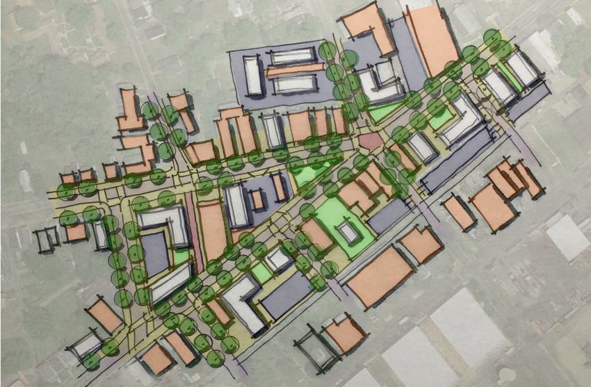
South Richmond — Western Nodes
Stony Point Shopping
Type: Neighborhood Node

Vision: The Stony Point Shopping Node currently consists of a suburban shopping center, a suburban
office park, both multi- and single-family dwellings, and a park. In the future, this Node can function as the
walkable, village center for the Bon Air and Huguenot neighborhoods in Richmond and Chesterfield County by
continuing to support a mix of uses in a more pedestrian-friendly and transit-ready environment. This mixed-
use Node will continue to be a neighborhood shopping destination with a unique mix of restaurants, retail,
neighborhood services, and entertainment options. New development or the redevelopment of the existing
suburban commercial and office development would be enhanced by encouraging a more urban form with
buildings that are closer to the street and parking located in the rear in shared lots, and the inclusion of some
residential units. The inclusion of green space and unique landscaping incorporated into developments will
continue to be a character defining feature of this Node. Pedestrian and bicycle connections throughout the
Node, across Huguenot Road, and to Larus Park should be improved. Transit service should continue to be
improved to provide access to more destinations and improved bus stop amenities.

Growth Potential: Medium – The surface parking lots and underdeveloped strip commercial can be
redeveloped to provide a mix of uses including residential.

Primary Next Steps
    – Rezone the Corridor Mixed-Use and Neighborhood Mixed-Use areas of this Node in alignment with the
      Future Land Use Plan to allow for a mix of uses and increased residential density by-right. (see Goal 1 and
      Goal 14)
    – Implement design standards to create a high-quality and well-designed neighborhood Node with
      extensive green space incorporated in developments and explore the creation of signature public art in a
      central gathering space. (see Goal 4 and Goal 17)
    – Improve pedestrian and bike infrastructure to/from this Node – specifically improving connections to
      Larus Park, the James River, and Stony Point Fashion Park, in coordination with Chesterfield County,
      across and along Huguenot Road. (see Goal 4 and Goal 8)
    – Expand transit service to this Node and improve bus stop amenities. (Goal 8)

Shops at Stratford Hills
Type: Regional Node

Vision: The Shops at Stratford Hills Node consists of two large commercial shopping centers which are
dominated by big box retailers and parking and strip commercial along Forest Hill Avenue. While residents
value the presence of large anchor establishments, in the future, this Node can be the walkable, mixed-use
neighborhood center for Stratford Hills by incorporating a diverse mix of uses including unique shopping,
service, and entertainment establishments and residential units. The existing suburban-style development
patterns focus around large parking lots that in the future could be redeveloped into a more urban, gridded
pattern with buildings that address the street. In addition to improved connections within the Node, Forest
Hill Avenue needs to be improved to reduce vehicle and pedestrian conflicts and improve pedestrian, bicycle,
and transit access to the Node. New development should have a cohesive plan, high quality design and include
street trees and other open space. Any new development in the areas to the south and east of the Node which
are designated Neighborhood Mixed-Use should complement the design of the Node and be connected by
both streets and sidewalks.

           FINAL - SEPTEMBER 2020                                                         Appendix C     | C-3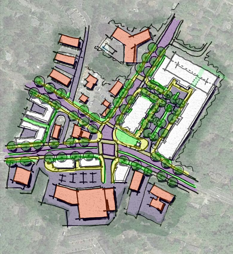
Growth Potential: Medium – The surface parking lots and underdeveloped strip commercial can be
redeveloped to provide a mix of uses including residential.

Primary Next Steps
    – Rezone this Node in alignment with the Future Land Use Plan to allow for a mix of uses and increased
      residential density by-right. (see Goal 1 and Goal 14)
    – Implement design standards to create a high-quality and well-designed regional Node with green space
      and street trees incorporated in developments and explore the creation of signature public art in a
      central gathering space. (see Goal 4 and Goal 17)
    – Incorporate a gridded street network as a part of the cohesive redevelopment of this Node. (See Goal 9)
    – Improve pedestrian and bike infrastructure to/from this Node – specifically improving connections into
      the residential neighborhoods and along Forest Hill Avenue.(see Goal 4 and Goal 8)
    – Implement high-frequency transit along Forest Hill Avenue (see Goal 8)

Stratford Hills
Type: Neighborhood Node

Vision: Currently, the Stratford Hills Node consists of two strip commercial centers on the north and south
sides of Forest Hill Avenue, strip commercial along Forest Hill Avenue, multi-family dwellings including a
13-story condominium tower, and parking lots adjacent to wooded residential neighborhoods. Additionally,
this Node is situated near entrances to the James River Park System; and in the future, the connections to
the Park should be improved. In 2037, the parking lots and dated commercial structures can be redeveloped
into a walkable mixed-use community center that continues to include unique local restaurants, retail, and
neighborhood services catering to the surrounding neighborhood and to differentiate this Node while also
incorporating multi-family residential units. Additional auto-related uses on the Forest Hill corridor should be
discouraged. Future development should encourage high-quality design and an urban form with medium-
scale buildings that are located closer to the street with parking located in the rear in shared lots. There is
the potential for additional larger multi-family and mixed-use development to complement the Hathaway
Towers. Enhancements are needed to improve the safety of pedestrians and bicyclist along Forest Hill Avenue
and access to the Node from the surrounding neighborhoods. The existing transit should be supported and
enhanced with more frequent routes and improved access to and amenities at the transit stops.

Growth Potential: Medium – The surface parking lots and underdeveloped strip commercial can be
redeveloped to provide a mix of uses including residential.

Primary Next Steps

  – Rezone this Node in alignment with the Future Land Use Plan to allow for a mix of uses and increased
    residential density by-right and discourages auto-related uses and suburban strip commercial
    development form. (see Goal 1 and Goal 14)

  – Implement design standards to create a high-quality and well-designed neighborhood Node that includes
    creative solutions for transitions between varying intensities of building types and land uses. (see Goal 4)

  – Improve pedestrian and bike infrastructure to/from this Node – specifically improving connections into the
    residential neighborhoods, along Forest Hill Avenue, and to the James River.(see Goal 4 and Goal 8)

  – Implement high-frequency transit along Forest Hill Avenue and connect riders to the bus stops along
    Forest Hill by providing increased pedestrian connections from the residential neighborhoods (see Goal 8)

C-4 |      RICHMOND 300: A GUIDE FOR GROWTH                                  FINAL - SEPTEMBER 2020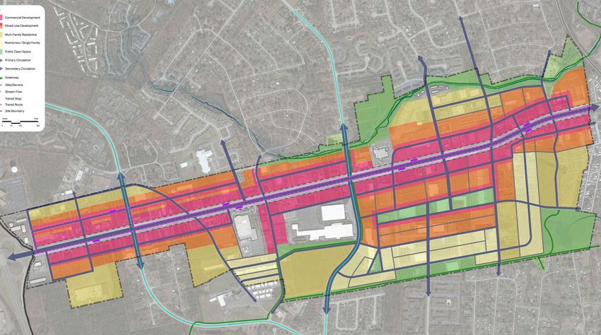
d
                                                                  oa
                                                                   R
                                                                ay
                                                              aw
                                                             th
                                                             Ha
                          Ol
                               d
                                   W
                                    es
                                         th
                                              am
                                                   Ro
                                                        ad

                                                              Fo
                                                                 re   st H
                                                                             ill A
                                                                                  ven
                                                                                      u   e

      Existing Building
      Infill Building

Stratford Hills Conceptual Site Plan

            FINAL - SEPTEMBER 2020                                                            Appendix C   | C-5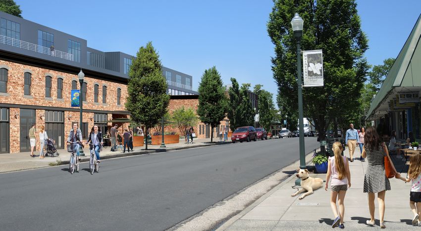
South Richmond — Central Nodes
     Westover Hills
     Type: Neighborhood Node

     Vision: Westover Hills has a village-like quality with small retail, services, and restaurant offerings that serve
     primarily the surrounding neighborhoods, but does attract outside visitors. Over the next twenty years, the
     Westover Hills Node could be enhanced by 1) discouraging suburban development pattern (where buildings
     are pushed back with parking in front of them) and encouraging urban form with buildings that are closer
     to the street and parking located in the rear in shared lots, and 2) utilizing a Complete Streets approach to
     street design to ensure pedestrians, bicyclists, and transit users are adequately and safely accommodated

            Fo

                                                                                           rd
               r   es

                                                                                        uleva
                        tH
                             ill
                                   Av

                                                                                      ll s B o
                                     en
                                          ue

                                                                                          Hi
                                                                                     over
                                                                                West
          Westover
            Hills
         Elementary

         Existing Building
         Infill Building

Westover Hills Conceptual Site Plan

     C-6 |          RICHMOND 300: A GUIDE FOR GROWTH                                      FINAL - SEPTEMBER 2020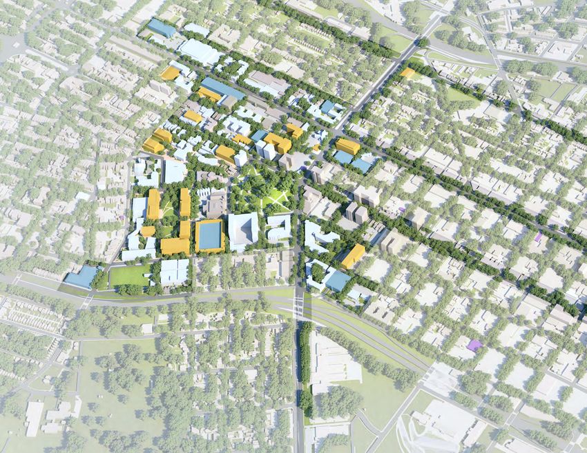
Westover Hills Potential Street Section Transformation
By bringing buildings just up to the sidewalk, leaving 3 to 5 feet for extra sidewalk space and/or outdoor seating, [as
shown in the bottom section], the Forest Hill street section can transform from feeling like a suburban-strip commercial
intersection [top] to an urban village intersection [bottom].

                 FINAL - SEPTEMBER 2020                                                         Appendix C    | C-7
in the public right-of-way. Additionally, the four corners of the Westover Hills/Forest Hill intersection can be
improved by bring buildings to the corner and introducing landmark public art.

Growth Potential: Low - while this is an important neighborhood Node in this area of the city and there are
parcels that could be redeveloped and improve the walkability and placemaking of this Node, the overall
growth potential, as compared to other Nodes city-wide, is low.

Primary Next Steps

  – Rezone the area to allow for residential uses by-right in the mixed-use area (see Goal 1 and Goal 14)

  – Implement design standards to create a high-quality and well-designed neighborhood Node and explore
    the creation of signature public art (see Goal 4 and Goal 17)

  – Improve pedestrian, bike, and transit infrastructure to/from this Node (see Goal 4 and Goal 8)

  – Implement high-frequency transit along Forest Hill Avenue and Westover Hills Boulevard (see Goal 8)

Chippenham Hospital
Type: National/Regional Node

Vision: The Chippenham Hospital Node is currently a job center anchored by HCA Healthcare Chippenham
Hospital. Additionally, there are many different housing options provided in the area including new and older
single-family homes, townhomes, and low-scale multi-family residential communities. This Node will continue
to provide high quality jobs associated with the hospital and medical office-related uses. Additionally, the older
multi-family residential communities can be redeveloped into higher density, mixed-use neighborhoods. The
redesign of these communities should emphasize walkable, well-connected communities with well-designed
buildings, a street grid, sidewalks, and street trees. New commercial uses incorporated into the mixed-use
communities and along Jahnke Road should serve both the residential population and hospital employees
and visitors. As this Node is located partially in Chesterfield County, connections to the County especially the
adjacent Boulder’s Office Park should be improved. Additionally, connections into Powhite Park should be
improved to increase accessibility to the park from the adjacent residential neighborhoods.

Growth Potential: Medium – The older low-density, multi-family developments can be redeveloped with a mix
of uses, higher residential densities and a mix of housing types.

Primary Next Steps

  – Rezone the Destination Mixed-Use and Neighborhood Mixed-Use areas of this Node in alignment with the
    Future Land Use Plan to allow for a mix of uses and increased residential density by-right. (see Goal 1 and
    Goal 14)

  – Rezone the Institutional areas of this Node in alignment with the Future Land Use Plan to require a master
    plan to be reviewed by Planning Commission for changes to the HCA Healthcare Chippenham Hospital
    campus. (Goal 13)

  – Improve pedestrian and bike infrastructure to/from this Node – specifically improving connections into the
    residential neighborhoods, along Jahnke Road and Hioaks Road, and to Powhite Park. (see Goal 4 and Goal
    8)

  – Connect Powhite Park to other City and regional parks through a system of greenways. (Goal 8 and Goal
    17)

  – Improve connections into Chesterfield County by extending Carnation Street under Chippenham Parkway
    to connect to Boulder’s Parkway in Chesterfield County. (see Goal 9)

C-8 |      RICHMOND 300: A GUIDE FOR GROWTH                                    FINAL - SEPTEMBER 2020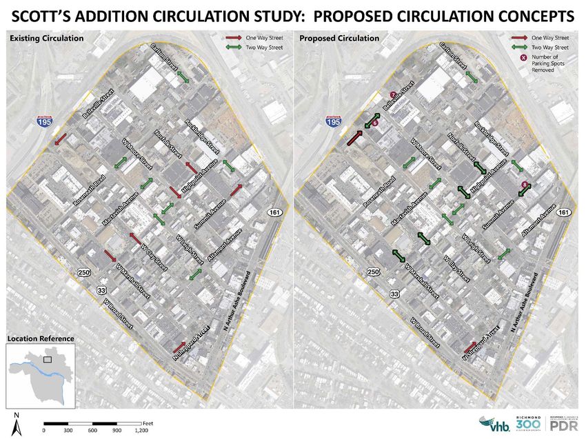
Midlothian/Chippenham
     Type: National/Regional Node

     Vision: The Node at Midlothian Turnpike and Chippenham Parkway serves as a gateway into the city of
     Richmond from Chesterfield County. Currently, this Node is developed with strip commercial, hotels, and a
     large off-track betting facility with a large surface parking lot. In 2037, this Node could become a walkable,
     village center that connects to the Stonebridge development in Chesterfield County and has its own unique
     identity as an attractive gateway into the city. The existing parking lots and undeveloped land at the southern
     edge can be redeveloped into a mixed-use community that includes a mix of housing types at varying
     affordability levels and community serving commercial uses. The scale of development should complement
     the surrounding neighborhoods and could include taller, signature buildings that serve to distinguish this
     Node. The development pattern should create a walkable environment by introducing a street grid to break
     up the larger parcels along Midlothian Turnpike and encouraging urban form with buildings that are closer to
     the street and parking located in the rear in shared lots. Enhancements are needed to improve the safety of
     pedestrians and bicyclist along Midlothian Turnpike at the intersection with Chippenham Parkway. Additional
     access into the Node from the county should be created by creating new streets.

     Growth Potential: High – The existing parking lots and undeveloped land at the southern edge can be
     redeveloped into a mixed-use community that includes a mix of housing types at varying affordability levels
     and community serving commercial uses.

     Primary Next Steps

       – Rezone this Node in alignment with the Future Land Use Plan to allow for a mix of uses and increased
         residential density by-right and discourages auto-related uses and suburban strip commercial
         development form (see Goal 1 and Goal 14)
                                                                     G e rm a n
                                                                        Sch ool

                                                      rn p   ike
                                         t hi   an Tu
                       C a rn

                                  M idlo
                        at io n

Midlothian Conceptual Plan

                FINAL - SEPTEMBER 2020                                                         Appendix C    | C-9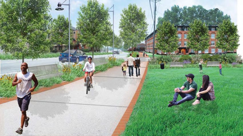
– Create an identity to differentiate this Node through branding and creative placemaking (see Goals 1 and
   4)

 – Incorporate a gridded street network as a part of the cohesive redevelopment of this Node (see Goal 9)

 – Improve pedestrian and bike infrastructure to/from this Node – specifically improving connections along
   Midlothian Turnpike into Chesterfield County and to the Southside Community Center (see Goal 4 and Goal
   8)

 – Improve connections into Chesterfield County by creating new streets under Chippenham Parkway to the
   Stonebridge development in Chesterfield County (see Goal 9)

 – Implement high-frequency transit along Midlothian Turnpike (see Goal 8)

Swansboro
Type: Neighborhood Node

Vision: Centered at a truly unique intersection of Midlothian Turnpike, Hull Street, and Clopton Street;
the Swansboro Node contains a mix of historic commercial storefronts, warehouses, and suburban form
commercial buildings surrounded by diverse residential neighborhoods. In the future, the empty historic
storefronts will be rehabilitated and filled with neighborhood-serving businesses. On the vacant parcels,
2-to-3 story, mixed-use, infill development should occur in a building form similar to the historic structures
that maintains the existing streetwall. The character of the surrounding residential neighborhoods should
be preserved with investments targeted to programs that allow homeowners to remain in their homes in
high-quality structures and traffic calming measures to slow vehicles on the residential streets. Open space
opportunities should be considered, even in the form of smaller pocket parks or plazas, where the opportunity
presents themselves, such as at the triangle formed by Hull Street and Midlothian Turnpike. Investments should
be made to improve the pedestrian experience by planting street trees and expanding sidewalks.

Growth Potential: Medium - The vacant lots and underdeveloped strip commercial can be redeveloped to
provide a mix of uses including residential units.

Primary Next Steps

 – Prioritize the rezoning of the B-3 zoned parcels along Hull Street in alignment with the Future Land
   Use Plan to encourage the economic revitalization of the corridor in a building form that improves the
   pedestrian environment (Goal 1 and Goal 11).

 – Encourage the redevelopment of vacant structures while preserving the historic urban fabric (Goal 1, Goal
   3).

 – Explore designation as a National Register Historic District (Goal 3).

 – Use the interesting grids and angles to create dynamic architecture (Goal 4).

 – Improve pedestrian, bike, and transit infrastructure to/from this Node – specifically including streetscape
   improvements of street trees, wider sidewalks, and pedestrian amenities along the corridors and providing
   high frequency transit along Midlothian Turnpike and Hull Street (see Goal 4, Goal 8, and Goal 17).

 – Explore the creative opportunities for developing open space for a neighborhood gathering location
   including the development of a pocket park or parklets (see Goal 4 and Goal 17).

 – Implement high-frequency transit along Midlothian Turnpike and Hull Street (see Goal 8).

C-10 |     RICHMOND 300: A GUIDE FOR GROWTH                                 FINAL - SEPTEMBER 2020
t
                                                                                                               r   ee
                                                                                                            St
                                                                                                       ll
                                                                                                  Hu

                              i   ke
                 ia n   Turnp
   Mi   d l ot h

                                                                                                Existing Building
                                                                                                Infill Building

Swansboro Conceptual Plan

     South Richmond – Eastern Nodes
     Hull/Warwick
     Type: Neighborhood Node

     Vision: The Node at Hull Street and Warwick Road is currently developed with small, single-use commercial
     structures and strip commercial centers supporting drugstores, small markets and auto-related businesses. The
     surrounding residential neighborhoods are composed of a mix of housing stock including single-family homes,
     a large apartment complex, and a manufactured home park. In the future, this Node can serve as a strong
     entrance into the city and function as a town and family entertainment center with mixed-use developments
     to include residential units and neighborhood serving commercial uses. Future development should encourage
     high-quality design and an urban form with medium-scale buildings that are located closer to the street
     with parking located in the rear in shared lots. The intersection of Hull Street and Warwick Road should be
     anchored on each corner by mixed-use buildings that are designed to enhance the “nodal” feeling of the area.
     Housing options at varying affordability levels should be provided throughout the Node by supporting and
     improving the existing housing stock and encouraging the construction of new housing units. Creative open
     space opportunities should be considered including in the form of smaller pocket parks or plazas. Pedestrian
     safety improvements including adequate sidewalks and lighting should be prioritized to improve the pedestrian
     experience.

     Growth Potential: Medium – There is large parcel in the southeast quadrant of the Warwick intersection that
     is almost entirely forested that can be developed as a significant mixed-use development to define the corner.

                          FINAL - SEPTEMBER 2020                                             Appendix C                     | C-11
local community interests and regional needs
The vision promotes nodes of clustered develo
linked by lower density segments. Its organizin
roadway itself; the neighborhood street networ
Hull Street; the creeks, green spaces and oth
Chippenham Parkway; and existing key destina
7.2 presents an illustrative concept design for th
Preliminary planning efforts by Virginia Comm
also offered valuable ideas for developing the H
the VCU study offered several key development
Figure 7.23: Visualization, Town and Family Entertainment Center corridor strengths, weaknesses, opportunities a
The second hub, at the Hull/Warwick intersection, is anchored on each
corner by mixed-use buildings, and designed to enhance the “gateway”
these goals, the VCU team proposed a series of
feeling of the area. The southeast quadrant is primarily residential, with helped informed the vision for the current Hull
workshop/retail land uses off of Warwick. Figure 7.21 displays precedent
images for the land uses proposed for the Town and Family Entertainment
Center. The vision for the Hull Street roadway, highligh
significant improvements to Hull Street itself, tr
79 HULL STREET CORRIDOR REVITALIZATION PLAN ribbon” that ties the area together and transfor
that is safe and comfortable for pedestrian an
convenient transit access, and includes low-impa
while maintaining its current vehicular capaci
analysis and recommendations are described in
The clustered “activity centers” vision recogn
amount of new development that will come to th
Conceptual Images for Town and Family Entertainment Center at Hull and Warwick
Source: Hull Street Corridor Revitalization Plan, January 2013
current conditions. In order to create the kinds
envisioned for Hull Street, new development
Additionally, many parcels are currently underdeveloped with significant surface parking lots which can be
directed to designated areas and conform to p
redeveloped.
patterns. The intent is not to reduce developm
Primary Next Steps corridor, but rather to incentivize developme
– Prioritize the rezoning of the B-3 and OS zoned parcels along Hull Street incenters. Development
alignment may still
with the Future occur in the co
Land
but will likely be at a less intense scale than tha
Use Plan to encourage the economic revitalization of the corridor in a building form that improves the
pedestrian environment. (Goal 1 and Goal 11) centers themselves.
– Support existing residents by developing programs that allow homeowners to remain in their homes in
high-quality structures and improving the quality of housing in the existing manufactured home parks
(Goal 14)
– Improve pedestrian, bike, and transit infrastructure to/from this Node – specifically including streetscape
improvements of street trees, wider sidewalks, and lighting along the corridors and providing high
frequency transit along Hull Street. (see Goal 4, Goal 8, and Goal 17)
– Explore the creative opportunities for developing open space for a neighborhood gathering location
including the development of a pocket park or a village green along Hull Street (see Goal 4 and Goal 17)
C-12 | RICHMOND 300: A GUIDE FOR GROWTH FINAL - SEPTEMBER 2020Hull/Chippenham
Type: Neighborhood Node
Vision: At the edge of the city, the Node at Hull Street and Chippenham Parkway is developed with a large
strip commercial center, smaller commercial buildings on Hull Street, low-density multi-family apartment
complexes, the new Cardinal Middle School, and surrounding single-family neighborhoods. This Node will
attract both city and county residents by providing neighborhood serving commercial and housing at varying
affordability levels in a more urban form. New development should include the redevelopment of the parking
lots along both sides of Hull Street with medium-scale buildings built closer to the street and parking located
in the rear in shared lots. Additionally, the low-density multi-family residential communities can be redeveloped
into higher-density, mixed-use neighborhoods. The redesign of these communities should emphasize creating
walkable, well-connected communities with well-designed buildings, a street grid, sidewalks, and street trees.
Improving pedestrian safety should be prioritized especially connections to the new school. The creation of
new open space and improved connections to Pocosham Park should be explored to provide additional access
to open space for residents of this community.
Growth Potential: Medium – There is development opportunity at Chippenham Mall Shopping Center, either in
the form of redevelopment, or existing large parking lots. The existing multi-family may be redeveloped a mix
of housing types at varying affordability levels and community-serving commercial uses. Many parcels in the
area are environmentally constrained due to the presence of Pocosham Creek.
Primary Next Steps
– Prioritize the rezoning of the B-2 and B-3 zoned parcels along Hull Street in alignment with the Future Land
Use Plan to encourage the economic revitalization of the corridor and the inclusion of residential units in a
building form that improves the pedestrian environment. (Goal 1, Goal 11, and Goal 14)
– Improve pedestrian, bike, and transit infrastructure to/from this Node – specifically including streetscape
improvements of street trees, wider sidewalks, and lighting along the corridors and providing high
frequency transit along Hull Street. (see Goal 4, Goal 8, and Goal 17)
– Incorporate a gridded street network as a part of the cohesive redevelopment of this Node (see Goal 9)
– Improve connections to Pocosham Park through the implementation of the Pocosham Greenway (Goal 8
and Goal 17)
West End Nodes
The Village
Type: Neighborhood Node
Vision: The Village is currently a suburban strip commercial district with many retail and office destinations;
however in the future, to support a more walkable, bikeable, and transit-ready environment, new developments
at the Village adopt a traditional “village center” feel with buildings at least 2-to-3 stories tall, located closer to
the street and with parking lots behind the buildings, and pedestrian and bike infrastructure. New development
should consider the addition of some residential units. The Community Mixed-Use future land use designation
at The Village allows for medium-scale mixed-use development, which is in harmony with the surrounding
residential neighborhoods and supports high-frequency transit.
Growth Potential: Low – since most of the land at this Node is in Henrico County, there is not much
development opportunity within the City
FINAL - SEPTEMBER 2020 Appendix C | C-13Primary Next Steps
Since the majority of The Village is in Henrico County, all planning should occur in close collaboration with
Henrico:
– Rezone The Village to allow for residential uses and increase height maximums (current B-2 prohibits
buildings taller than 35 feet) (see Goal 1 and Goal 14)
– Implement design standards to create a high-quality and well-designed neighborhood Node and explore
the creation of signature public art at this gateway (see Goal 4)
– Improve pedestrian and bike infrastructure through The Village and specifically from The Village to Bandy
Park (see Goal 4, Goal 8, and Goal 17)
– Implement high-frequency transit along Patterson Avenue with a transit stop at Patterson Avenue and
Three Chopt Road (see Goal 8)
Broad/Staples Mill
Type: Neighborhood Node
Vision: The area around the intersection of W. Broad Street and Staples Mill Road capitalizes on its proximity
to Willow Lawn, Scott’s Addition, Libbie Mill, and the Pulse BRT Staples Mill Station to redevelop under-
developed parcels into a walkable Node with new, denser, mixed-use buildings, and streetscape improvements
along Broad transform Broad Street into a truly Great Street. The Destination Mixed-Use future land use
designation at intersection of Broad and Staples Mill encourages the development of landmark buildings
that identify this area as a major gateway into the city. The Corridor Mixed-Use future land use designations
encourages the development of buildings that address the street and support a walkable environment along
Broad Street.
Growth Potential: Medium – There are several large parcels with surface parking lots and low-slung buildings
that could be redeveloped to capitalize on the proximity to high-frequency transit by providing employment
and housing.
Primary Next Steps
Since a portion of this area is in Henrico County, all of the next steps should occur in close collaboration with
Henrico:
– Rezone the area to allow for residential uses and increase height maximums (current B-3 promotes single-
use suburban strip commercial development, not transit-oriented development) (see Goal 1 and Goal 14)
– Implement design standards to create a high-quality and well-designed neighborhood Node and explore
the creation of signature public art and/or open space at this gateway (see Goal 4 and Goal 17)
– Improve pedestrian and bike infrastructure to/from the Pulse BRT Staples Mill Station (see Goal 4 and Goal
8)
– Improve W. Broad Street to transform it into a Great Street by creating a bus-only lane, widening
sidewalks, burying power lines, enhanced landscape, and requiring buildings to address the street (see
Goal 1, Goal 4, and Goal 9)
Westhampton
Type: Neighborhood Node
Vision: The Node that stretches from Libbie and Grove to Libbie and Patterson provides retail and
services to nearby residents and attracts visitors from across the region to its businesses. Over time, a few
underdeveloped parcels redevelop in a matter that complements and enhances the existing village-scale
C-14 | RICHMOND 300: A GUIDE FOR GROWTH FINAL - SEPTEMBER 2020feel of the area. The Community Mixed-Use future land use designation permits the creation of additional
residential units and business, while also ensuring that new buildings are an appropriate scale the existing
commercial buildings and promote walkability by placing vehicular access to the rear of the building. The
intersection of Libbie and Patterson should be carefully planned and redeveloped to support and increase
access to the high-frequency transit planned for Patterson Avenue.
Growth Potential: Low – While this is an important neighborhood Node in this area of the city, aside from the
redevelopment of a handful parcels, this Node will not significantly change over the next 20 years
Primary Next Steps
– Rezone the area to allow for residential uses by-right in the Community Mixed-use area and retain a
maximum height of three stories (see Goal 1 and Goal 14).
– Implement design standards to create a high-quality and well-designed neighborhood Node that is
consistent with the village-feel of the area, and explore the creation of signature public art (see Goal 4 and
Goal 17).
– Improve pedestrian and bike infrastructure to/from this Node (see Goal 4 and Goal 8).
– Implement high-frequency transit along Patterson Avenue with a transit stop at Patterson Avenue and
Libbie (see Goal 8).
Broad/Malvern
Type: Neighborhood Node
Vision: This Node is no longer a “dead spot” between Scott’s Addition and Willow Lawn; but rather a place
with multi-family residential options mixed with retail and offices. New development supports walkable,
bikeable, and transit-ready environment to support a new Pulse BRT Station at Malvern and Broad.
Growth Potential: Medium – There are several large parcels with surface parking lots and buildings that could
be redeveloped to capitalize on the proximity to high-frequency transit by providing employment and housing.
Primary Next Steps
– Rezone the area to allow for residential uses by-right in the Corridor Mixed-Use area (see Goal 1 and Goal
14).
– Engage with GRTC to discuss the next steps to develop an infill station at Broad and Malvern (Goal 8).
Near West End Nodes
Carytown
Type: Regional/National Node
Vision: The Carytown Node is a lively mixed-use neighborhood that is home to Richmond’s premier shopping
destination. The establishments in Carytown include an eclectic mix of local and national retail, dining,
entertainment, and service uses anchored by the historic Byrd Theater to the east and multiple grocery stores
to the west. The retail corridor is surrounded by diverse residential neighborhoods which include a variety
housing stock. In 2037, Carytown will continue to be a successful, walkable, mixed-use destination. Additional
residential units at a range of affordability levels can be developed through compatible infill development
and developing 2 to 3 stories of residential above existing commercial structures. New development should
be compatible with the existing historic structures, and efforts should be made to preserve the existing
FINAL - SEPTEMBER 2020 Appendix C | C-15historic fabric. Though Carytown currently is a walkable Node, the movement of people not cars should be
further prioritized by limiting vehicular access to Cary Street, whether permanently or temporarily, while
accommodating other modes of transportation. Pedestrian amenities including street trees and larger
sidewalks should be included on Cary Street and into the surrounding residential communities. Opportunities
to create new open space and improve existing spaces including the Grayland Tot Lot should be realized.
Growth Potential: Medium – New development is limited to existing parking lots and the redeveloping single-
and two-story structures into taller structures.
Primary Next Steps
– Rezone the area to allow for residential uses and increase height maximums (current B-3 promotes single-
use suburban strip commercial development, not transit-oriented development, and UB prohibits buildings
taller than 28 feet) (Goal 1 and Goal 14).
– Explore the opportunity for permanent or temporary street closure of Cary Street in Carytown to limit use
to bicycle, pedestrian, transit, and retail use (Goal 8).
– Implement design standards to create a high-quality and well-designed neighborhood Node while
preserving the existing historic fabric and explore the creation of signature public art (Goal 3, Goal 4).
– Improve pedestrian, bike, and transit infrastructure to/from this Node – specifically including streetscape
improvements of street trees, wider sidewalks, and lighting into the surrounding neighborhoods including
into Carytown South and City Stadium neighborhoods and across I-195 and providing high frequency
transit along Cary Street and Ellwood Avenue (Goal 4, Goal 8, and Goal 17).
– Explore the creative opportunities for developing open space for a neighborhood gathering location
including the development of a pocket park or parklets (Goal 4 and Goal 17).
– Implement the recommendations of the Parking Study (Goal 9)
– Consider creating a Business Improvement District for Carytown (Goal 11)
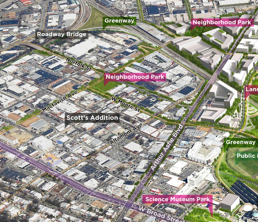
Scott's Addition
Type: Regional/National Node
Vision: Scott’s Addition continues its evolution as a mixed-use neighborhood by adding more residential,
office, entertainment, and "maker" uses. The area adds neighborhood amenities, such as a park or parklets,
sidewalks, street trees, and other features that enhance the public realm. Scott's Addition is better connected
to the West and North by new bridges and is served by high-frequency transit. W. Broad Street and Arthur
Ashe Boulevard transform into a pair of high-quality urban avenues that are safe to cross, while becoming a
destination in their own right for residential, office, retail and compatible entertainment uses.
Growth Potential: Medium/High — There are still several surface parking lots and buildings that could be
redeveloped
Primary Next Steps
– Explore incentives and programs to encourage private developers to create more publicly-accessible
greenspace on their properties (Goal 4).
– Improve pedestrian, bike, and transit infrastructure to/from this Node — specifically including a greenway
around the perimeter of Scott's Addition and streetscape improvements of street trees, wider sidewalks,
and lighting (Goal 4, Goal 8, and Goal 17).
– Provide high-frequency transit along Arthur Ashe Boulevard and into Scott's Addition (Goal 8).
– Implement the recommendations to improve circulation within Scott's Addition found in the Scott's
Addition Circulation Study (Goal 9).
C-16 | RICHMOND 300: A GUIDE FOR GROWTH FINAL - SEPTEMBER 2020Proposed Bike Infrastructure and Circulation for Scott's Addition
Figure 14 - Proposed Two-Way Streets
Source: Scott's Addition Planning Study to Improve Circulation and Implement Multimodal, Vision Zero, and Complete Streets Concepts, July 2019
Figure 15 – Proposed Bicycle Improvements
39 36
| P a| gPea ge
Scott's Addition Conceptual Aerial
A greenway and neighborhood park add
public green space to Scott's Addition
FINAL - SEPTEMBER 2020 Appendix C | C-17– Build a pedestrian bridge from Mactavish to Rosedale and a car/bike/transit/pedestrian bridge from
Norfolk to Hamilton (Goal 9).
– Implement the recommendations of the Parking Study (Goal 9).
– Consider creating a Business Improvement District for Scott's Addition (Goal 11).
– Develop at pocket park at Cutshaw and a larger park within Scott's Addition (Goal 17).
Broad/Hermitage
Type: Regional/National Node
Vision: Building off its excellent access to high-frequency transit with the Pulse Rapid Transit Allison
Station, the Broad/Hermitage is known as the Alison District, a dense, compact, transit-oriented mixed-use
development anchored by a reconnected street grid. Major redevelopment around the Allison Station breaks
up superblocks by introducing a street grid, developing a series of parks connected by greenways, and
creating a walkable environment with high-density, mixed-use buildings on the north side of W. Broad Street;
medium-density, mixed-use buildings infill the south side of W. Broad Street.
As redevelopment proceeds, an infill Pulse station at Lombardy Street facilitates transit connections
and access to jobs, daily shopping, and homes at the Lombardy Street and W. Broad Street intersection.
Redevelopment occurs on sites with auto-oriented uses and deep setbacks that currently disrupt the historic
pattern of the street-oriented commercial corridor. Historic building stock is preserved and adapted for reuse.
New development provides adequate buffers to residential neighborhoods. W. Broad Street transforms into
a high-quality Great Street that is safe to cross, while becoming a destination in its own right for residential,
office, retail and compatible entertainment uses.
Broad/Hermitage Conceptual Aerial
A greenway and series of parks add public green space to the Broad/Hermitage area
C-18 | RICHMOND 300: A GUIDE FOR GROWTH FINAL - SEPTEMBER 2020Growth Potential: Medium/High — There are still several surface parking lots and buildings that could be
redeveloped.
Primary Next Steps
– Rezone the Broad/Hermitage area to align with the Future Land Use Map. (Goal 1)
– Work with Sauer Properties to develop an urban form master plan. Take advantage of the large
concentration of single-owner redevelopment properties north of W. Broad Street and work together
towards a high-density, urban form. (Goal 1, Goal 4)
– Introduce a street grid north of W. Broad Street using Complete Streets guidelines. Continue Clay Street
from DMV Drive to Lombardy Street, Marshall Street from DMV Drive to Bowe Street, Meadow Street from
Clay Street to Leigh Street, and Allison Street to Clay Street as redevelopment occurs. (Goal 9)
– Improve north-south crossings of A. Broad Street for pedestrians and cyclists in the general vicinity of
Hermitage and Lombardy Streets and explore the creation of an east-west bike route between Belvidere
Street and Boulevard. (Goal 8)
– Prioritize the segment of W. Broad Street from Lombardy Street to Boulevard for streetscape
improvements to transform W. Broad Street a Great Street. (Goal 9)
– Build a landscaped bridge from W. Leigh Street to the Diamond Site and eliminate the at-grade crossing
at Hermitage and the railroad tracks in order to increase safety and accommodate the DC to Richmond
Southeast High Speed Rail. (Goal 9)
– Work with the Commonwealth to retain state employees and improve existing development, including
looking at opportunities for repurposing large amounts of surface parking at the DMV Headquarters and
the fleet facility on W. Leigh. (Goal 1, Goal 11)
VCU/Monroe Park
Type: Regional/National Node
Vision: VCU/Monroe Park continues to provide shopping, dining, and housing for students and neighborhood
residents alike. VCU is a major job center and nexus of activity with services and cultural attractions for
the region. The intersection of Belvidere and W. Broad Streets becomes a signature intersection with new
development complementing the VCU Institute for Contemporary Art with prominent architecture. A new
high-frequency transit line runs down Belvidere with a stop at Belvidere and W. Broad Street. VCU's campus
evolves as VCU continues to modernize its buildings. W. Broad Street and Belvidere transform into a high
quality urban avenues that are safe to cross, while becoming destinations in their own right for residential,
office, retail and compatible entertainment uses.
Growth Potential: Low — While there are some opportunities for VCU to redevelop its buildings and land;
there are not many.
Primary Next Steps
– Continue to improve pedestrian, bike, and transit infrastructure to/from this Node – specifically connecting
to the Monroe Park campus east across Belvidere to Monroe Ward (Goal 4, Goal 8, and Goal 17)
– Provide high-frequency transit along down Route 1 with a major stop at Broad and Belvidere (Goal 8)
– Continue to reinforce the gridded street network by reducing superblocks and maintaining connectivity
(Goal 9)
– Explore a PILOT program for large non-profit institutions in the city (Goal 13)
FINAL - SEPTEMBER 2020 Appendix C | C-19Proposed
Master Plan
KEY
NEW CONSTRUCTION
/RENOVATION
EXISTING STRUCTURED
PARKING
e
VCU LEASED BUILDING
Lei
er
et
gh
re
id
EXISTING VCU BUILDING
St r
e et
lv
St
Be
on
ri s
ar
H B ro
ad
St r
e et
Fra
n klin
St r
e et
ONE VCU Master Plan 7
A portion of VCU's Master Plan showing the Monroe Park Campus
source: One VCU Master Plan
North Richmond Nodes
6
Azalea
Type: Neighborhood Node
Vision: The Azalea Node is located on the border with Henrico County and is centered at the intersection of
Azalea and Chamberlayne Avenues. Today the area consists of auto-oriented businesses such as gas stations,
banks, and fast food restaurants, surrounded by residential neighborhoods to the south. In the future, the
area can be transformed into a mixed-use area with a more urban form and a higher image quality as a major
gateway into the city of Richmond. While there is not a lot of vacant land, the presence of auto-oriented
businesses with large parking lots provides the opportunity for ample redevelopment. New development
should be between 2 and 5 stories in height and have buildings that face the street with parking in the rear.
Improved streetscapes with wider sidewalks and more trees will enhance the look and feel of the area, and
improved transit, bicycle, and pedestrian access will make the area safer and more accessible to all.
Growth Potential: Medium – Many of the existing businesses uses sit on large parcels with more space devoted
to parking than to buildings. Redevelopment of these structures provide an excellent opportunity to add more
commercial and residential uses while overhauling the character of this Node.
Primary Next Steps
– Rezone the Corridor Mixed-Use areas of this Node along Azalea Avenue, which is currently zoned “B-2
Community Business District”, in alignment with the Future Land Use Plan to allow for a mix of uses and
increased residential density by-right (see Goal 1 and Goal 14).
– Implement high-frequency transit along Brook Road and Chamberlayne Avenue (see Goal 8).
C-20 | RICHMOND 300: A GUIDE FOR GROWTH FINAL - SEPTEMBER 2020Potential Transformation of MacArthur
A new building could potentially fill in across the street from the existing stores and restaurants across the street.
– Improve pedestrian and bike infrastructure to/from this Node – specifically improving the streetscapes of
Azalea Avenue, Brook Road, and Chamberlayne Avenue (see Goal 4 and Goal 8).
– Implement design standards to create a high-quality and well-designed neighborhood Node and explore
the creation of signature public art (see Goal 4 and Goal 17).
MacArthur
Type: Neighborhood Node
Vision: The MacArthur Node is a small and cherished commercial area embedded within the Bellevue
neighborhood in Northside, located along MacArthur Avenue. Currently and in the future, the Node provides
commercial uses within walking distance to the surrounding community at a scale and intensity that is
compatible with the residential neighborhood which surrounds it. Existing structures are between 1 and 2
stories in height, and future development should be between 2 and 4 stories in height. There are currently no
vacant parcels within the commercial area of the Node, but there are opportunities for redevelopment as there
are several parcels that have either an excess of parking or a form and character that does not enhance the
overall neighborhood commercial corridor. For instance, the apartment court on the west side of MacArthur
Avenue could be redeveloped into a mixed-use structure that fronts the street and has parking underground.
Growth Potential: Low – There are opportunities for redevelopment of underutilized parcels which should be
at a scale and intensity that is compatible with the existing commercial corridor and surrounding residential
neighborhood.
Primary Next Steps
– Rezone this Node, the commercial portion of which along MacArthur Avenue is zoned “B-1 Neighborhood
Business District” in alignment with the Future Land Use Plan to allow for a mix of uses and increased
FINAL - SEPTEMBER 2020 Appendix C | C-21Redeveloped Façades on Brookland Park Boulevard
Source: Brookland Park Boulevard Revitalization Plan, February 2013
residential density by-right and discourages auto-related uses and suburban strip commercial
development form. (see Goal 1 and Goal 14)
– Implement design standards to ensure a high-quality and well-designed neighborhood Node and explore
the creation of signature public art (see Goal 4)
– Improve pedestrian and bike infrastructure to/from this Node, including providing bike parking. (see Goal 4
and Goal 8)
Brookland Park
Type: Regional/National Node
Vision: Today Historic Brookland Park Boulevard is home to some local businesses that receive customers
from all over the city; however, many storefronts are vacant and dilapidated. Brookland Park was developed
when streetcars ran up North Avenue. In 2037, Brookland Park Boulevard will continue to feature long-term
businesses, but as the adjacent residential neighborhoods continue to regain population, the empty storefronts
will fill with neighborhood-serving businesses. Street landscaping will grow and new public art will recognize
the unique character of this commercial corridor.
Growth Potential: Low — While there are empty parcels and storefronts, this Node will not see a significant
proportion of the City’s growth over the next 20 years
Primary Next Steps
– Encourage the redevelopment of vacant structures (Goal 1, Goal 3).
– Explore the creation of signature public art (Goal 4).
– Develop wayfinding and parking signage (Goal 4).
C-22 | RICHMOND 300: A GUIDE FOR GROWTH FINAL - SEPTEMBER 20206 Points Current State
6 Points Re-imagined
Potential Transformation of Six Points
Architecture firm, HKS, led a process to create a schematic plan for a building in Six Points. HKS created the plan through
a robust community engagement process for a unique live/work building that is envisioned to incubate local businesses
on the first floor and provide mixed-income housing above.
Source: re-imagining benefield, a plan for a property in Highland Park, HKS Architects, 2019
– Implement Parking Study recommendations (Goal 9).
– Assist long-term businesses in redeveloping areas by providing them rehabilitation grants and/or loans,
and tax relief as property taxes increase (Goal 11).
– Support the Brookland Park Area Business Association in creating marketing and promotional materials
(Goal 11).
Six Points
Type: Neighborhood Node
Vision: The Six Points Node is centered on a unique six-way intersection that was recently improved with
a roundabout and landscaping. Small-scale, neighborhood commercial uses are located at the intersection
and extend up Meadowbridge Road. The expansive Highland Park residential neighborhood surrounds this
commercial area. In the future, this area can be a more enlivened community center with more neighborhood
services and residential uses, better connectivity to and around the area, and more placemaking and public art
amenities that focus on the history and cultural assets of the area. Future development should be between 2
and 4 stories and be sensitive to the surrounding residential neighborhood which exists in close proximity. The
Hotchkiss Community Center and associated recreational assets can be better linked and incorporated to the
activity of this Node.
Growth Potential: Low – The commercial area of the Node is relatively constrained and there are few vacant
parcels. There are, however, several parcels that are underutilized and could be redeveloped into a building
form and use that more closely fits with the vision of the area.
Primary Next Steps
FINAL - SEPTEMBER 2020 Appendix C | C-23VIeW Of tHe neIGHbOrHOOd Center
Potential Transformation of Lombardy and Chamberlayne
The City adopted the VUU/Chamberlayne Neighborhood Plan to guide development. In 2019, the City rezoned this area of33
V U U/Ch a mber l ay ne Ne ighbor ho od Pl a n: R ich mon d, V irgin i a | sep t e mber 2015 | ur b a n de sign a ss o c i at e s
Ne ighbor ho od s w i t hin t he Dis tr ic t
town to align with the Plan to encourage walkable urban development in the Lombardy/Chamberlayne area..
Source: rVUU/chamberlayne Neighborhood Plan, 2015
– Rezone the Community Mixed-Use areas of this Node at the intersection and along Meadowbridge Road
in alignment with the Future Land Use Plan to allow for a mix of uses and increased residential density by-
right (see Goal 1 and Goal 14).
– Improve pedestrian and bike infrastructure to/from this Node – specifically examining the feasibility
of bicycle facilities (such as a bike lane) along Brookland Park Boulevard from this Node west to
Chamberlayne Avenue (see Goal 4 and Goal 8).
– Implement design standards to create a high-quality and well-designed neighborhood Node and explore
the creation of signature public art (see Goal 4 and Goal 17).
– Foster the unique identity of this Node through branding and creative placemaking (see Goals 1 and 4).
VUU/Chamberlayne
Type: Neighborhood Node
Vision: The VUU/Chamberlayne Node is centered at a unique V-shaped intersection of Chamberlayne Avenue
and N. Lombardy Street. Commercial uses line both streets with surrounding residential neighborhoods.
Virginia Union University exists to the southwest of the Node along N. Lombardy Street. Many of the
commercial uses are auto-oriented with parking lots either in the front or side of the buildings. Commercial
uses along N. Lombardy Street are more present along the street, but many are older car service businesses,
some of which no longer appear to be operating.
The VUU/Chamberlayne Neighborhood Plan (2015) established a future vision for this Node through
extensive community input: “Lombardy between Brook and Chamberlayne is an ideal location for a
pedestrian-friendly retail and shopping district. Today, an overabundance of automobile- oriented uses,
parking lots, and vacant buildings discourage the development of a strong connection between the
surrounding neighborhoods and the commercial area. Lombardy and adjacent streets should be changed to
C-24 | RICHMOND 300: A GUIDE FOR GROWTH FINAL - SEPTEMBER 2020allow on-street parking, streetscaping, pedestrian lighting and signage. Curb cuts should be reduced to better
control vehicular movement, and parking areas should be created behind buildings and in public lots. New
commercial buildings with storefronts can be located along Lombardy, and selected historic buildings can be
reused for shops and restaurants. The focus of the district will be a new public square at the intersection of
Lombardy and Overbrook that will feature attractive landscaping and public art.”
In addition to the established vision, Richmond 300 envisions a future of this Node that is served by enhanced
transit along Brook Road and Chamberlayne Avenue, improved bicycle facilities that make biking to and from
the Node safer and easier, and roadway design improvements that see the pleasant, boulevard character of
Brook Road and Chamberlayne Avenue to the north of the Node extended further south through the area and
towards Downtown.
Growth Potential: Medium – Though the parcels are relatively small in size, the commercial area within this
Node is fairly large in total. There are some vacant parcels and many parcels are underutilized because they
are only 1-story in height or have an abundance of surface parking on them. Future development should be
between 2 and 5 stories with sensitive design consideration where parcels abut residential neighborhoods.
Primary Next Steps
– Improve pedestrian and bike infrastructure to/from this Node – specifically examining the feasibility of
bicycle facilities (such as a bike lane) along Chamberlayne Avenue (see Goal 4 and Goal 8).
– Construct the Fall Line Trail which is proposed to be located along Brook Road and will serve as a bicycle/
pedestrian connection between Ashland and Petersburg running through Richmond (see Goal 9).
– Improve the streetscape and extend the boulevard character of Chamberlayne Avenue and Brook Road
further south through this Node (See Goal 4 and Goal 9).
– Implement design standards to create a high-quality and well-designed neighborhood Node and explore the
creation of signature public art (see Goal 4 and Goal 17).
– Implement high-frequency transit along Brook Road and Chamberlayne Avenue (see Goal 8).
East End Nodes
25th and Nine Mile
Type: Neighborhood Node
Vision: The intersection of N. 25th Street and Nine Mile Road is located at the center of the East End,
consisting of commercial and institutional uses. The long-envisioned grocery store has been realized in the
form of the Market at the 25th which is located on formerly-vacant land on the north side of the intersection.
Improvements to the intersection in the form of a new roundabout have been recently completed. Institutional
uses that help anchor the Node, which are in addition to the commercial uses along N. 25th Street and
Nine Mile Road, include the East End Library, the J. Sargent Reynolds Culinary School, and the Richmond
Community Hospital run by Bon Secours.
In the future, this Node can be an even better version of itself, continuing to serve the commercial and civic
needs of East End residents. Its location at the center of East End can be a bridge between the neighborhoods
to the north and the Union Hill and Church Hill neighborhoods to the south. Vacant parcels that exist along the
commercial corridor are developed into mixed-use and commercial uses that front the street. Underutilized
parcels with non-historic structures and parking lots fronting the street are redeveloped. Vacant residentially-
zoned parcels within proximity to the intersection of 25th and Nine Mile are developed into residential uses
FINAL - SEPTEMBER 2020 Appendix C | C-25You can also read