Permit Application under section - 96A - Lincoln Heath South Oct 2014 - Amazon AWS
←
→
Page content transcription
If your browser does not render page correctly, please read the page content below
Permit
               Application
               under section
               96A

Oct 2014       Lincoln Heath South
               Stage 1-4 Subdivision

TPG Ref:1952   Client:   Australand Property Group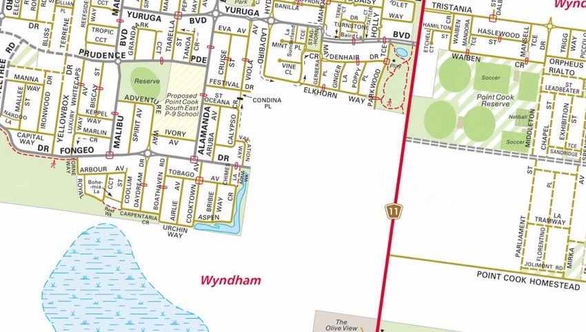
PLANNING APPLICATION | Stage 1-4 Subdivision & Dwellings on lots under 300sqm

Planning Application
STAGE 1 -4 SUBDIVISION

PROJECT SYNOPSIS
ADDRESS:
                             380-438 Point Cook Road, Point Cook

ZONING:
                             Urban Growth Zone (UGZ); General Residential Zone (GRZ),

PSP:
                             Lincoln Heath South PSP 1207.1

OVERLAYS:
                             Development Plan Overlay (DPO2)

PROPOSAL:                    Staged residential subdivision into 146 lots (stages 1-4) and
                             development of dwellings on lots under 300sqm and create access
                             to a road in a road zone category 1.

                             Whole Site Area:        43.32 hectares

                             Stages 1-4 Area:        11.59 ha

                             Net Developable
                                                     9.834 ha
                             Area Stages 1-4:
ELEMENTS OF PROPOSED
DEVELOPMENT                  Number of Lots
                                                     Subdivision of the land into 146 lots
                             Stages 1-4:
                             Density Stages 1-4:     14.8 dwellings per ha
                             Whole site density:     17.5 dwellings per ha
                                                                              2
                                                     - 11 allotments of >300m
                                                                                  2
                             Lot Sizes:              - 90 allotments of 301-500m
                                                                              2
                                                     - 45 allotments of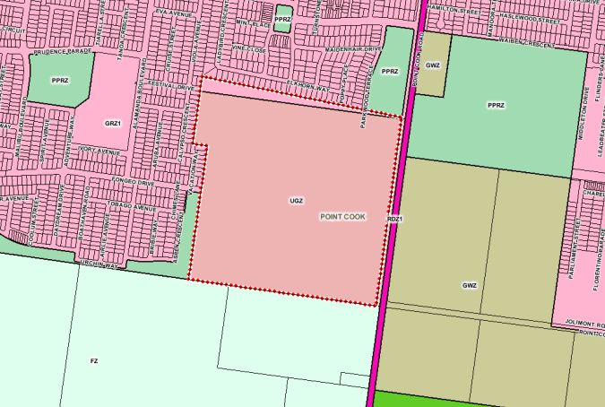
PLANNING APPLICATION | Stage 1-4 Subdivision & Dwellings on lots under 300sqm

Document Information
Prepared for:      Australand Property Group
Job Reference:     1952
Date:              29 October 2014

Contact Information
Nicole Guirguis
Australand Property Group
Level 9, 484 St Kilda Road, Melbourne, VIC 3004
Mob 0411 057 567
Tel 03 9258 1280

Document Control
Version                 Date                      Author         Reviewer

Draft                   29 October 2014           Trisha Brice   Phillip Rygl

                                                                                Page 2
PLANNING APPLICATION | Stage 1-4 Subdivision & Dwellings on lots under 300sqm
Table of Contents
PROJECT SYNOPSIS .......................................................................................................................................... 1
INTRODUCTION ............................................................................................................................................... 5
BACKGROUND ................................................................................................................................................. 5
SITE & SURROUNDS ......................................................................................................................................... 7
THE SITE................................................................................................................................................................ 7
SITE FEATURES........................................................................................................................................................ 7
SURROUNDING ENVIRONS......................................................................................................................................... 8
THE PROPOSAL ................................................................................................................................................ 9
OVERALL SITE ......................................................................................................................................................... 9
STAGES 1-4 ........................................................................................................................................................... 9
DEVELOPMENT OF DWELLINGS ON LOTS UNDER 300SQM .............................................................................................. 10
ROAD LAYOUT ...................................................................................................................................................... 10
SITE ACCESS ......................................................................................................................................................... 11
BIODIVERSITY, FLORA AND FAUNA ............................................................................................................................ 11
TRAFFIC AND TRANSPORT ....................................................................................................................................... 12
SURFACE WATER MANAGEMENT ............................................................................................................................. 13
SERVICES ............................................................................................................................................................. 13
ANEF CONTOURS ................................................................................................................................................. 14
ASSESSMENT OF PROPOSAL .......................................................................................................................... 15
ZONE PROVISIONS ................................................................................................................................................. 15
OVERLAY PROVISIONS ............................................................................................................................................ 16
PARTICULAR PROVISIONS ........................................................................................................................................ 17
STATE PLANNING POLICY FRAMEWORK ..................................................................................................................... 20
LOCAL PLANNING POLICY FRAMEWORK ..................................................................................................................... 22
CONCLUSION ................................................................................................................................................. 26
APPENDIX ONE | ............................................................................................................................................ 27
APPENDIX TWO | ........................................................................................................................................... 28
APPENDIX THREE | ........................................................................................................................................ 29
APPENDIX FOUR | .......................................................................................................................................... 30
APPENDIX FIVE | ............................................................................................................................................ 31
APPENDIX SIX | .............................................................................................................................................. 32
APPENDIX SEVEN | ........................................................................................................................................ 33
Page 3PLANNING APPLICATION | Stage 1-4 Subdivision & Dwellings on lots under 300sqm
APPENDIX EIGHT | ......................................................................................................................................... 34
APPENDIX NINE | ........................................................................................................................................... 35
APPENDIX TEN | ............................................................................................................................................ 36
APPENDIX ELEVEN | ....................................................................................................................................... 37
APPENDIX TWELVE | ...................................................................................................................................... 38
Page 4PLANNING APPLICATION | Stage 1-4 Subdivision & Dwellings on lots under 300sqm
INTRODUCTION
This application has been prepared on behalf of Lincoln Heath Estates Pty Ltd as trustee of
the Trust Project No. 9 Unit Trust (Australand), for the subdivision of land at 380-438 Point
Cook Road, Point Cook. This land is otherwise known as the Lincoln Heath South estate. In
particular, this application seeks approval for the creation of Stages 1-4.
The application is being made under Section 96A of the Planning and Environment Act 1987
for the staged residential subdivision of the land, creation of access to a road in a road zone
and development of dwellings on lots under 300sqm to accompany the Amendment which
will introduce the Lincoln Heath South PSP (1207.1).
The land is located in the Urban Growth Zone (with a small section of land zoned General
Residential along the northern boundary which is a cadastral mapping error). The land is
situated within the Urban Growth Boundary and the Lincoln Heath South (PSP 1207.1)
Precinct Structure Plan (PSP) has been prepared by the Metropolitan Planning Authority
(MPA).
Historically, the land was always intended to be developed for residential purposes, forming
an extension to the nearby Lincoln Heath Estate to the north, and also the neighbouring
Alamanda Estate.
This proposal will see the land subdivided for residential purposes in a manner which is both
consistent with the PSP prepared by the MPA, and also consistent with the surrounding
residential neighbourhood. Due consideration has been made to the site constraints
including the presence of native flora and fauna, as well the need to provide appropriate
road access to and through the site, the need to provide appropriate infrastructure and
services and ensure that an appropriate level of amenity is provided for future residents.
Ultimately, the proposal will deliver a well-designed development that enhances the dwelling
and lifestyle opportunities of existing and future residents within the municipality.
BACKGROUND
This land has been the subject of change over the last 10 years.
In 2011, the site was considered by the State Government’s Logical Inclusions Ministerial
Advisory Committee, whose purpose it was to advise the Minister for Planning on the
suitability of properties proposed for inclusion within the Urban Growth Boundary (UGB).
Overall the Committee recommended 14 Assessment Areas for inclusion within the UGB
with a further 16 Assessment Areas recommended for possible future review. The
Committee reviewed submissions made by the Growth Area Councils, Government
Page 5PLANNING APPLICATION | Stage 1-4 Subdivision & Dwellings on lots under 300sqm
Agencies, landowners and affected parties, a total of 316 submissions were made within the
western precinct alone.
It was recommended by the Logical Inclusions Ministerial Advisory Committee that the
subject site, described as part of Wyndham Area 1 and identified as 360 Point Cook Road,
be rezoned as Urban Growth Zone. This recommendation was accepted by the Minister for
Planning and Council. The rigorous process of assessment undertaken by the Advisory
Committee ensured the site could achieve compliance with both State and Local Planning
Policy Frameworks and also took into consideration existing constraints and opportunities.
At present, the land is being developed by the Metropolitan Planning Authority as the Lincoln
Heath South Precinct Structure Plan (PSP 1207.1) and its development is therefore
supported by both State and Local Government. The preparation of the PSP is currently
ongoing and this application seeks to be considered alongside the resultant documentation.
Page 6PLANNING APPLICATION | Stage 1-4 Subdivision & Dwellings on lots under 300sqm
SITE & SURROUNDS
THE SITE
The subject site is an approximately 43.32 hectare site located within an area of Point Cook
that is being developed for residential estates. Land to the north and west has been
developed and is well established, with land to the south located in the PSP area that will be
developed for residential development.
The site is generally rectangular in shape, generally falls to the south and is currently vacant
agricultural land. Historically, the land has been regularly cropped and grazed with cereal
grain.
The site provides an excellent infill opportunity connecting to the existing surrounding
residential development including the Lincoln Heath Estate and the neighbouring Alamanda
Estate.
Subject Site
Figure 1 Location Map - Melways
Refer Appendix 1 – Certificate of Title
SITE FEATURES
Site features, as outlined in the various consultant reports prepared to support this
application, include:
Gentle rise to a ridge across the north eastern corner of the site which falls gradually
back to a flat low lying area in the southern and western sections of the site;
In the south western corner of the site, there is a relatively large area that is likely to
be seasonally inundated with water that contains indigenous flora species.
Page 7PLANNING APPLICATION | Stage 1-4 Subdivision & Dwellings on lots under 300sqm
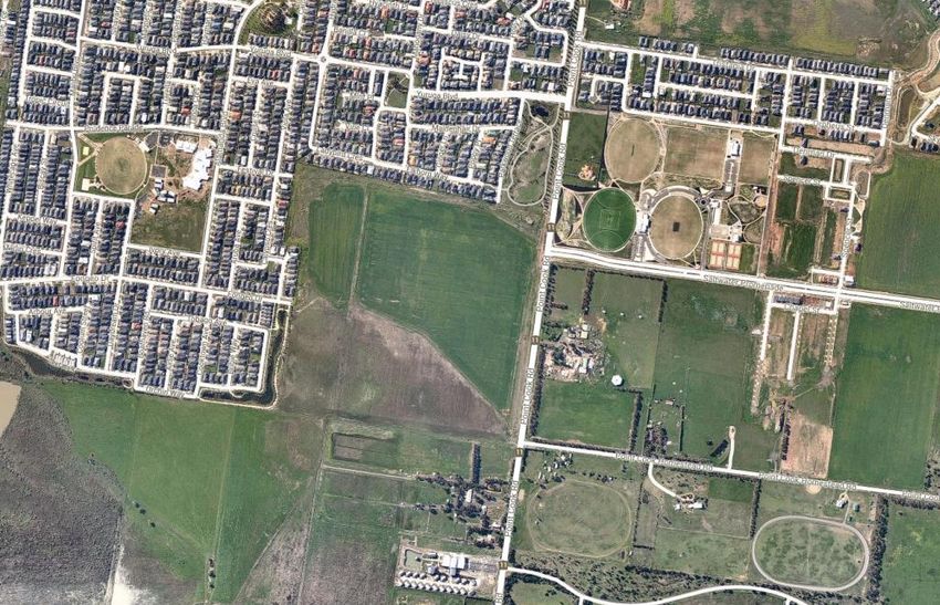
SURROUNDING ENVIRONS
The site is located within the Lincoln Heath South Precinct Structure Plan with Australand
being the sole owner of the whole PSP area.
The site is bordered by existing residential developments Lincoln Heath Estate to the north
and Alamanda Estate to the west. Currently farmland, the land located to the immediate
south of the site is included within the future Point Cook South Precinct Structure Plan. Point
Cook Road borders the site to the east whilst surrounding developments provide
opportunities for additional road connections at other boundaries.
Due to the site’s proximity to existing developments it is within the vicinity of a range of
relatively new facilities and infrastructure. Nearby educational/childcare facilities include:
Alamanda College (Point Cook South-East P-9 School) (250 metres west),
Alamanda Leisure Centre and Childcare Centre (1.2 kilometres north),
Proposed Point Cook South P-9 School (2.5 kilometres north-west),
Carranballac P-9 College and Jamieson Way Community Centre Kindergarten (2.2
kilometres north); and
Lumen Christi Catholic Primary School (1.8 kilometres north).
Recreational opportunities include the Point Cook Reserve to the immediate east which
comprises a number of sporting facilities catering to football, cricket, netball, tennis, soccer
and hockey. In addition, a network of passive open spaces are located to the north-east and
south-west of the development providing access to walking and cycling trails. Other parks
such as Bayview Park, Meeting Place Park, Featherbrook Park, and a number of additional
open spaces are also located within a 3 kilometre radius of the subject site, whilst Sanctuary
Lakes Golf Club is located approximatley 2.5 kilometres north-east.
The dominant retail centre for the area is the Sanctuary Lakes Shopping Centre located 1.5
kilometres north along Point Cook Road. The centre contains a number of anchor stores
including Coles, Aldi and Kmart with a number of smaller stores such as pharmacies, a
newsagent, bakery, gym, realestate agent, Commonwealth Bank, and various eateries
among others also located within the centre.
An alternative shopping destination, the Point Cook Town Centre is located approximately
4.5 kilometres to the north-west along Dunnings Road and provides a local hub for retail,
commercial and community facilities with shopping centres uniquely integrating with Main
and Murnong Streets providing a number of useable public open spaces. The Town Centre
contains the Wyndham Library Service Point, Australia Post Office, Medical Centre and a
number of professional services.
Additional amenities include the Point Cook Medical Centre and Guardian Medical located
along Point Cook Road to the north, as well as a number of specialist health facilities in the
locality.
Refer to Appendix 2 – Site Location and Context Plan
Page 8PLANNING APPLICATION | Stage 1-4 Subdivision & Dwellings on lots under 300sqm
THE PROPOSAL
OVERALL SITE
This application has been submitted as one part of the overall subdivision and development
of the site known as 360-483 Point Cook Road, Point Cook. The site, a total of 43.32
hectares in area, is to become the new Lincoln Heath South Estate. In general, the
development of the Estate will include provision for conventional residential density, medium
residential density living opportunities, as well as areas of public open space and
conservation areas. The overall estate is expected to be developed for approximately 600
dwellings. This application applies to stages 1-4 of the entire estate.
Fongeo Drive will extend from the existing Alamanda Estate in the west, to continue north-
east through the site connecting with Point Cook Road. This will form the main connector
road for the development in conjunction with an additional connector following the
conservation area to the south to provide a future connector road to the Point Cook South
PSP area.
A large portion of the site will be dedicated wetlands and conservation precinct containing a
mixture of passive parks, grassland and EPBC/EVC areas. This area is located in the south-
western site corner and will connect with existing wetlands within the Alamanda Estate.
Proposed wetlands along the southern site boundary will act as retarding basins to facilitate
the appropriate maintenance and treatment of stormwater.
The development of the site integrates well with neighbouring estates and will provide a high
level of amenity for future residents.
STAGES 1-4
The subdivision and future development of the Lincoln Heath South Estate has been divided
into distinct stages. The planning application at hand seeks approval for stages 1-4
(inclusive), located within the north-eastern site corner, as outlined below.
Stage 1 of the development will involve the construction of Fongeo Drive from the Alamanda
Estate in the west, up to its intersection with Point Cook Road intersection. This stage will
comprise of fifty-four (54) allotments as well as the creation of a substantial area of centrally
located public open space. Development will occur to the southern edge of the existing
Lincoln Heath Estate, and will continue south to the southern side of Fongeo Drive.
Stage 2 of the development will see the creation of a service street parallel to Point Cook
Road and the development of thirty-four (34) allotments along this frontage spreading west.
A connection to Fongeo Drive from this stage will also occur.
Page 9PLANNING APPLICATION | Stage 1-4 Subdivision & Dwellings on lots under 300sqm
Stage 3 will follow to the south-west of Stages 1 and 2 and will include the provision of
twenty-five (25) allotments and will be connected to both Sages 1 and 2 via a residential
street network.
Stage 4 will comprise of thirty-three (33) allotments north of Fongeo Drive and adjacent
Stage 1 of the development. Excepting Parkwood Terrace, this will be the first stage to
provide a meaningful connection to the Lincoln Heath Estate to the north, whereby a reserve
will act as a pedestrian accessway linking the estates.
At the completion of stages 1-4 the north-eastern corner of the site will be developed to
contain, along with the requisite roads and infrastructure:
- 11 allotments of >300m2;
- 90 allotments of 301-500m2;
- 45 allotments ofPLANNING APPLICATION | Stage 1-4 Subdivision & Dwellings on lots under 300sqm
Whilst residential streets located adjacent to the site boundaries are typically orientated in a
north-south and east-west direction for integration with neighbouring estates, in response to
the location of Fongeo Drive a proportion of streets run either north-east to south-west, or
north-west to south-east. All roads within the subdivision have been designed with safety
and ease of access in mind.
A new intersection treatment to Point Cook Road will be required at the intersection with
Fongeo Drive that is being worked through with VicRoads, Council and the MPA.
SITE ACCESS
Primary site access will be via Point Cook Road to the east and will require the construction
of a new intersection capable of providing for predicted traffic flows as generated by the
development as a whole (not just stages 1-4). In addition, access will also be made from the
existing Lincoln Heath Estate to the north via connection to Parkwood Terrace, and from
Alamanda Estate to the west via an extension to Fongeo Drive.
It is noted that a traffic report has been completed by Cardno at the instruction of the MPA
and forms part of the background reports for the PSP.
BIODIVERSITY, FLORA AND FAUNA
The application is supported by a Biodiversity Assessment prepared by Ecology and
Heritage Partners Pty Ltd (EH Partners) dated October 2014 which assesses the land as a
whole and for the PSP (not stages 1-4 exclusively). The assessment was undertaken to
identify and characterise local vegetation, determine the presence (or likelihood of) any
significant flora and fauna species and/or ecological communities, and address any
implications under Commonwealth and State environmental legislation.
The report identifies that the majority of the study area, being the subject site, consists of
cleared agricultural land which has recently been cropped, with other introduced flora
species around the edges of the site. However, in the south western corner of the site, there
is a relatively large area that is likely to be seasonally inundated with water that contains
indigenous flora species.
Key findings of the assessment are set out below:
61 flora species recorded (32 indigenous, 29 non-indigenous);
o No significant flora species observed during assessment but noted that there
marginal habitat present for one flora species of national conservation
significance and several species of State conservation significance;
25 fauna species recorded;
o No significant fauna species recorded; however there is habitat suitable for
fauna species of both national State and regional conservation significance;
Page 11PLANNING APPLICATION | Stage 1-4 Subdivision & Dwellings on lots under 300sqm
Vegetation within parts of the site consistent with the condition thresholds for one
ecological community of national significance.
It is noted that the ecological community of national significance (being Seasonal
Herbaceous Wetlands (Freshwater) of the Temperate Lowland Plains) will not be impacted
by the proposed residential subdivision and development, and Australand are proposing to
retain all potential habitat for significant flora and fauna.
However, there is a small area of remnant vegetation to be removed to facilitate the
construction of wetland system within the southern portion of the overall site for drainage
purposes. This has been assessed by EH Partners and is deemed to fall under the Low risk-
pathway, with a total of 0.336 habitat hectares (0.483 ha) of remnant vegetation proposed for
permitted removal. Under the low risk-pathway, there is no requirement for avoidance or
minimisation of impacts; rather offset requirements must be met.
It should be noted that a permit is not required for further native vegetation removal within
stages 1-4 due to the exemptions of Clause 52.17 for Regrowth which apply ‘…for regrowth
which has naturally established or regenerated on land lawfully cleared of naturally
established native vegetation…’ and is ‘less than 10 years old’. The Rushy Plains Wetland
located within this precinct is covered by this exemption as outlined within the EH Partners
Biodiversity Assessment.
The trigger to remove vegetation is not required for the current planning application for
Stages 1 – 4 and will be addressed in a subsequent permit when the construction of the
wetlands is required.
It should also be noted that a referral to the Commonwealth Environment Minister will be
made to ensure compliance with the EPBC Act as recommended by EH Partners. This will
pertain to threatened species and ecological communities (matters of National
Environmental Significance) present on the entirety of the land and will be a referred as a
non-controlled action.
It is noted that all NES are being retained as part of the proposed development.
Refer Appendix 4 – Biodiversity Assessment
TRAFFIC AND TRANSPORT
Residential subdivision and development of the subject site has been the subject of a
number of traffic assessments prepared by Cardno.
Page 12PLANNING APPLICATION | Stage 1-4 Subdivision & Dwellings on lots under 300sqm
It is proposed that the development be provided with its primary access connection to Point
Cook Road at the intersection with Saltwater Promenade. This will be a signalised
intersection designed to accommodate predicted traffic flows as generated by the
development as a whole (not just stages 1-4).
As stated earlier, the site will be served by a main east-west connection through the site to
Fongeo Drive in the neighbouring Alamanda Estate. This connection will serve as an
alternative to the Sneydes Road thoroughfare. North south connections will be provided to
the remainder of the Estate from Fongeo Drive.
Traffic Report Available Upon Request
SURFACE WATER MANAGEMENT
The application is supported by a Surface Water Management Strategy prepared by Neil M
Craigie Pty Ltd dated 24 September 2014. This report details the proposed drainage
strategy for the proposed subdivision.
Consistent with discussions held between Neil Craigie and Melbourne Water, the drainage
design is based on connection of low flow drainage to the Alamanda system, providing for a
linked wetland concept “…to best minimise fill depth requirements, address EVC
requirements, provide best practice water quality management, and provide sufficient flood
storage capacity to ensure maintenance of existing peak flow regimes discharged to the
south. The distance between wetland segments and design of interconnecting pipelines is
required to “… conform with the accepted design as negotiated previously in the Alamanda
Estate.”
More specifically, there will be new wetlands / retarding basins constructed within the
southern portion of the site, connected via a 1200mm diameter pipeline, ultimately
connecting to the existing Alamanda sediment basin south of Fongeo Drive.
Refer Appendix 5 - Surface Water Management Strategy
SERVICES
The application is supported by a Services Report prepared by Brown Consulting dated
October 2014. The report sets out preliminary engineering advice with respect to the
provision of services and infrastructure required to develop the site for residential purposes.
Key features of the Services Report are set out below:
Earthworks: it is expected that up to 2.5m of fill will be required within the majority of
the southern areas of the site to elevate the dwellings above the major flood level;
Stormwater and drainage: refer Neil Craigie report. This includes construction of
wetlands / retarding basins with interconnecting pipe to connect to Alamanda
drainage system.
Page 13PLANNING APPLICATION | Stage 1-4 Subdivision & Dwellings on lots under 300sqm
Potable water: to be serviced via existing 300mm DICL main located along the west
side of Point Cook Road, with secondary connections made to existing watermains
within the adjoining Alamanda and Lincoln Heath developments. The applicant will be
required to extend water mains to each allotment created;
Re-use Water Supply: Due to the limited availability of re-use water, it is intended
that re-use water be supplied for irrigation of public open space only;
Sewerage: the site will be serviced by extensions to the local sewer networks from
the west off access chamber FEE14. Refer Appendix E of the Report;
Electricity Supply: the site will be serviced by the augmentation and extension of
underground supply within the site from existing overhead assets in Point Cook Road
along with connections to adjoining estates.
Gas Supply: the site will be serviced from the existing 100mm diameter steel plastic
coated main in Point Cook Road, with secondary connections provided to the
adjoining estates; and
Telecommunications: the developer will be required to provide adequately sized
and located pit and pipe conduit infrastructure to accommodate the NBN dire optic
service.
Where required, the applicant / developer will enter into agreements with the relevant service
authorities to ensure that each lot is appropriately serviced.
Refer Appendix 6 – Services Report
ANEF CONTOURS
The site is located north-west of the RAAF Williams Airbase; with the nearest point of the
development site being approximately 1.1km from the northern end of runway 17/35
(north/south runway).
The subject site is located outside of the ANEF 20 contour. As such, no noise attenuation
measures are required to be provided for dwellings in this subdivision as per Australian
Standard 2021 which nominates the ANEF 20 contour as the acceptable level for the
building of new residential dwellings without attenuation.
It is noted that Australand, Wyndham City Council and the MPA have agreed that a
Memorandum of Common Provisions (MCP) in the form of Design Guidelines will apply to
the site and would refer to the ANEF contours. These guidelines may include
measures/restrictions with respect to building materials, height and roof colours.
Page 14PLANNING APPLICATION | Stage 1-4 Subdivision & Dwellings on lots under 300sqm
ASSESSMENT OF PROPOSAL
ZONE PROVISIONS
For the purposes of this application, the site is considered to be wholly located within the
Urban Growth Zone (UGZ). The purpose of the Urban Growth Zone is, amongst other
matters, to:
To implement the State Planning Policy Framework and the Local Planning Policy
Framework, including the Municipal Strategic Statement and local planning policies.
To manage the transition of non-urban land into urban land in accordance with a
precinct structure plan.
To provide for a range of uses and the development of land generally in accordance
with a precinct structure plan.
To contain urban use and development to areas identified for urban development in a
precinct structure plan.
To provide for the continued non-urban use of the land until urban development in
accordance with a precinct structure plan occurs.
To ensure that, before a precinct structure plan is applied, the use and development
of land does not prejudice the future urban use and development of the land.
Subject Site
Figure 2 Zoning Map – Planning Maps Online
Pursuant to Clause 37.07-3, a permit is required to subdivide the land.
Urban Growth Zone Schedule
Page 15PLANNING APPLICATION | Stage 1-4 Subdivision & Dwellings on lots under 300sqm
Assessment
The proposal is consistent with the intent and purpose of the Urban Growth Zone in that it
will facilitate the transition of non-urban land into urban land capable of meeting the present
and future residential growth needs of the municipality.
This transition will occur in accordance with and consistently with the Lincoln Heath South
Precinct Structure Plan (PSP 1207.1) prepared by the Metropolitan Planning Authority in
conjunction with Wyndham City Council, Government agencies, service authorities and
major stakeholders.
An assessment against Clause 56 is also included as an appendix to this report.
Ultimately the proposed subdivision will provide for a range of uses as identified within the
proposed Lincoln Heath South PSP and until such time as the PSP is approved, the use and
development of the land will not prejudice the future urban use and development of the land.
An assessment against the State and Local Planning Policy Frameworks is included later in
this report.
It should be noted that a section of the site located along the northern property boundary is
zoned General Residential Zone – Schedule 1. This is thought to be attributed to an
inconsistency in the cadastral boundary and as such a portion of proposed allotments will be
partially located within this zone. This is not anticipated to create any non-compliance as all
of the requirements of Clause 56 are to be met.
Refer to Appendix 7 – Clause 56 Assessment
OVERLAY PROVISIONS
The site is located within the Development Plan Overlay – Schedule 2 (DPO2).
It is noted that under the PSP process it is proposed to remove the DPO2 from the land and
therefore an assessment against the DPO2 is not considered necessary.
This application is being considered under Section 96A of the Planning and Environment Act
1987 and therefore the application is being considered against the PSP and UGZ.
The proposed subdivision has therefore been designed in accordance with the Lincoln Heath
South PSP and the State and Local Planning Policy Frameworks as the relevant planning
framework. The site is identified as an area appropriate for future development. The
proposal incorporates a future road layout with regard to lot orientation and neighbourhood
amenity. Accesibility, safety and useability have all been taken into consideration in the
Page 16PLANNING APPLICATION | Stage 1-4 Subdivision & Dwellings on lots under 300sqm
design of the proposed subdivision through appropriate placement of open spaces and
provision of key infrastructure.
Ultimately the proposed subdivision will deliver a high quality residential precinct capable of
catering for the growth of the municipality and the needs of its current and future residents.
Refer to Appendix 8 – Assessment against PSP Guidelines
PARTICULAR PROVISIONS
Clause 52.01- Public Open Space Contribution and Subdivision
This clause specifies the provision of public open space contribution required when
subdividing land. The schedule to this clause states that under the PSP, a contribution of
3% is required to be provided for this site. The overall plan for the site as proposed provides
for a total of 3.38% contribution of unencumbered public open space which exceeds the
requirements of this clause.
Clause 52.29 - Land adjacent to a Road Zone Category 1
This clause specifies that a planning permit is required to create or alter access to a road in
a road zone category 1.
The proposed development includes the construction and connection of Fongeo Drive
connecting to Point Cook Road, which is a declared VicRoads road. Therefore, a planning
permit is required under this clause.
Australand have been working with VicRoads, MPA and Council throughout the PSP
process on the intersection treatment and design. A report prepared by Cardno indicates the
need to signalise the Point Cook Road / Saltwater Promenade / Lincoln Heath South Estate
intersection in order to cater for the full development of the Lincoln Heather South Estate
and the continued development of the Saltwater Promenade Estate.
Ultimately future development of the site and the creation of access to Point Cook Road, a
Road Zone Category 1 road, will not adversely affect the operation of the road or level of
public safety. Appropriate traffic management techniques will mitigate any impact on traffic
volumes along the road.
Page 17PLANNING APPLICATION | Stage 1-4 Subdivision & Dwellings on lots under 300sqm
Clause 56 – Residential Subdivision
This policy provides a range of objectives and standards in relation to the subdivision of the
land for residential purposes. The purpose of Clause 56 is outlined as follows:
To implement the State Planning Policy Framework and the Local Planning Policy
Framework, including the Municipal Strategic Statement and local planning policies.
To create liveable and sustainable neighbourhoods and urban places with character
and identity.
To achieve residential subdivision outcomes that appropriately respond to the site
and its context for:
o Metropolitan Melbourne growth areas.
o Infill sites within established residential areas.
o Regional cities and towns.
To ensure residential subdivision design appropriately provides for:
o Policy implementation.
o Liveable and sustainable communities.
o Residential lot design.
o Urban landscape.
o Access and mobility management.
o Integrated water management.
o Site management.
o Utilities.
Assessment
A thorough assessment against the provisions of Clause 56 as well as the PSP Guidelines
prepared by MPA has been completed and the proposed development reaches a high level
of compliance, thus demonstrating the proposal’s suitability for this site and acceptability
having regard to local amenity, neighbourhood character and built form outcomes.
Refer to Appendices 7 and 8 – Clause 56 Assessment and Assessment against PSP
Guidelines
Precinct Structure Plan (PSP1207.1)
A detailed assessment of the proposed subdivision against the PSP Guidelines as prepared
by MPA is provided in Attachment 8 of this report.
The PSP is structured around key themes of Image and Character, Housing, Heritage, Open
Space, Biodiversity and Threatened Species, Bushfire Management, Transport, Walking and
Cycling, Water management, Servicing and Staging.
Page 18PLANNING APPLICATION | Stage 1-4 Subdivision & Dwellings on lots under 300sqm
The proposed Lincoln Heath South Estate responds positively to the Standards set out by
the PSP Guidelines. Several matters contained within the draft Guidelines have been
separately discussed with the MPA and it is understood that some requirements are set to
change. Overall the proposal achieves an appropriate level of compliance with the vision and
objectives the MPA have established for Lincoln Heath South.
Refer to Appendix 8 – Assessment against PSP Guidelines
Other Planning Controls
The site is located within an area of Aboriginal Cultural Heritage Sensitivity and the
preparation of a Cultural Heritage Management Plan (CHMP) is required for subdivision of
the land into three or more lots pursuant to the Aboriginal Heritage Regulations 2007 and the
Aboriginal Heritage Act 2006. A CHMP has been completed and approved under the
preparation of the Lincoln Heath South PSP. All salvage works have been successfully
completed.
Figure 4 Cultural Heritage Sensitivity – Planning Maps Online
Refer to Appendix 9 – Cultural Heritage Management Plan
Page 19PLANNING APPLICATION | Stage 1-4 Subdivision & Dwellings on lots under 300sqm
STATE PLANNING POLICY FRAMEWORK
The relevant clauses include:
Clause 9 – Plan Melbourne
This clause states that where relevant, planning and responsible authorities must consider
and apply the strategy Plan Melbourne: Metropolitan Planning Strategy (Department of
Transport, Planning and Local Infrastructure, 2014).
Clause 11 – Settlement
Seeks to anticipate and respond to the needs of existing and future communities through
provision of zoned and serviced land for housing, employment, recreation and open space,
commercial and community facilities and infrastructure.
Clause 11.02 – Urban Growth
Seeks to ensure a sufficient supply of land is available for residential, commercial, retail,
industrial, recreational, institutional and other community uses by locating urban growth
close to transport corridors and services and providing efficient and effective infrastructure to
create benefits for sustainability while protecting primary production, major sources of raw
materials and valued environmental areas.
Relevant strategies to achieve this include:
Implementing the strategic directions within the Growth Area Framework Plans
(Department of Sustainability and Environment 2006).
Encouraging average overall residential densities in the growth areas of a minimum
of 15 dwellings per net developable hectare.
Meet housing needs by providing a diversity of housing type and distribution.
Retain unique characteristics of established areas incorporated into new
communities to protect and manage natural resources and areas of heritage, cultural
and environmental significance.
Create well planned, easy to maintain and safe streets and neighbourhoods that
reduce opportunities for crime, improve perceptions of safety and increase levels of
community participation.
Clause 12 – Environmental and Landscape Values
Seeks to protect the health of ecological systems and the biodiversity they support (including
ecosystems, habitats, species and genetic diversity) and conserve areas with identified
environmental and landscape values.
Relevant strategies to achieve this include ensuring that decision making takes into account
the impacts of land use and development on Victoria’s high value biodiversity by minimising
impacts on Victoria’s biodiversity and where native vegetation is permitted to be removed,
ensuring that an offset is provided in a manner that makes a contribution to Victoria’s
Page 20PLANNING APPLICATION | Stage 1-4 Subdivision & Dwellings on lots under 300sqm
biodiversity that is equivalent to the contribution made by the native vegetation to be
removed.
Clause 16 – Housing
Seeks to provide for housing diversity, and ensure the efficient provision of supporting
infrastructure making certain that housing has access to services and is planned for long-
term sustainability including walkability to activity centres, public transport, schools and open
space.
Strategies to provide this include ensuring housing developments are integrated with
infrastructure and services, whether they are located in existing suburbs, growth areas, or
regional towns.
Clause 19 – Infrastructure
This clause seeks to plan for the development of social and physical infrastructure that
enables it to be provided in a way that is efficient, equitable, accessible and timely. The
growth of settlements should allow for the logical and efficient provision and maintenance of
infrastructure, including the setting aside of land for the construction of future transport
routes. Providers of infrastructure, whether public or private bodies, are to be guided by
planning policies and should assist strategic land use planning.
Response
The proposed development of the land for residential subdivision is consistent with the
strategies and supports the objectives of the State Planning Policy Framework.
This proposal complies with the intents and purposes of the State Planning Policy
Framework. The proposal provides a well-designed development which will improve the
housing choice available in the City of Wyndham. The proposal respects the surrounding
neighbourhood character of existing estates and protects the amenity of the adjacent
properties.
The proposed master plan (including stages 1-4 and the overall plan) meets the objectives
and purposes of Clause 11.02 by:
Being consistent with the West Growth Area Framework Plan by allowing this site,
nominated as a PSP area and within the Urban Growth Boundary;
The master plan will provide for an overall dwelling density of 17.5 dwellings per ha,
which is in excess of the 15 dwellings per ha set out in this clause;
Retains key environmental assets of the land, including significant vegetation; and
Will be a properly master planned community with access to open space, transport
routes and existing and planned services.
Page 21PLANNING APPLICATION | Stage 1-4 Subdivision & Dwellings on lots under 300sqm
The proposed subdivision takes into consideration landscape values identified within and
surrounding the site offering a considerate design with minimal impact on natural features.
Further, in terms of Environmental Values (Clause 12), the proposed master plan is seeking
to retain all National Environmental Significance (NES) EVC’s on the site which achieves the
purpose and aims of this clause by retaining and enhancing natural environmental values.
The proposal will promote the sustainable urban growth of Point Cook, ensuring a sufficient
supply of land is made available for the growing population. The development of the land will
provide additional housing diversity in the area, including the provision of new housing on
small lots, under the Small Lot Housing Code, that will add important diversity of housing
options in the area as sought under Clause 16 – Housing.
LOCAL PLANNING POLICY FRAMEWORK
Council’s Municipal Strategic Statement sets out Council’s vision and strategies for the
future development of the City on a range of issues and geographic areas.
Clause 21.02 – Profile of Wyndham
Wyndham is one of Melbourne’s principal growth areas with urban growth primarily being
driven by new residential development. As an area favoured by young home-buyers,
Wyndham has a high proportion of conventional family households. Residential development
largely comprises single detached dwellings on relatively large allotments. The provision of
multi-unit residences is low compared with the metropolitan area as a whole. Current
household formation rates and residential density outcomes suggest that upwards of 1,000
dwellings will be constructed annually.
Clause 21.03-2 – Wyndham’s Urban Growth Framework
Council has prepared detailed plans for three priority growth fronts within Wyndham.
These are the most cost-effective areas for expansion based on current servicing costs and
potential demand. The growth fronts are:
Wyndham North
Werribee West
Point Cook
Concept plans for each of these areas outline the broad infrastructure and land-use
requirements for an additional population of around 150,000, with development expected to
occur over 20 to 30 years.
Key issues facing the City of Wyndham today concern rapid population growth, location of
growth, major industrial and employment areas, transport, infrastructure, rural areas,
environment, and urban design and image.
Page 22PLANNING APPLICATION | Stage 1-4 Subdivision & Dwellings on lots under 300sqm
Clause 21.04 – Wyndham’s Vision
Wyndham’s strategic vision provides the foundation for land-use planning policy in the
municipality. The vision can be refined into ten key land-use planning objectives which are
the basis for more specific strategies and actions, as outlined in Clause 21.05. The ten
objectives of land-use planning in Wyndham are:
The cost-effective and orderly management of urban growth, balancing the city and
country aspects of the municipality.
Access to a range and quality of housing opportunities which meet the needs of the
population.
Accessible, safe and efficient options for the movement of people and goods within,
into, and out of, the municipality.
The generation of sufficient job opportunities to meet the needs of a growing
population and which develop greater sustainability in employment for Wyndham and
the region.
Establishment of a network of current and future activity centres which satisfy a
range of retail, commercial and community needs and which create a sense of place
within the community.
Access to a range of leisure and recreational opportunities which meet the needs of
the population and which can be provided cost-effectively.
Protection and enhancement of significant areas and features of the built and natural
environment, and maintenance of environmental and heritage values.
Attraction of new visitors to Wyndham based on optimal use of existing features and
assets, and enhancement of areas of environmental interest.
Productive use of rural land, ensuring compatibility with land care values and
effective separation from urban purposes.
Positive re-focusing of Wyndham’s image and appearance, building on its rural
land/open space and landscape qualities and ensuring that it is appealing to
residents, investors and visitors alike.
Clause 21.05 – Objectives and Strategies
Council’s strategies are to:
Provide for growth on a scale consistent with maintaining the containment,
compactness, accessibility and affordability of the municipality’s key growth areas,
namely:
o Werribee West
o Point Cook
o Wyndham North
Facilitate new development which is predicted on a demonstrated capacity to provide
essential infrastructure for the incoming population.
Provide for new development to occur in areas that are not isolated from the core
urban are and which integrate well with existing communities and physical
infrastructure.
Page 23PLANNING APPLICATION | Stage 1-4 Subdivision & Dwellings on lots under 300sqm
Clause 22.03 – Infrastructure Financing Policy
This policy provides a framework for the identification and apportionment of the cost of basic
infrastructure in new urban development areas throughout the municipality. Its objective is to
ensure that requisite urban infrastructure provided at the local level is determined on a
transparent and equitable basis.
Clause 22.07 – Open Space Policy
This policy applies to the provision of recreational open space in Wyndham and exists in
response to the growing population and increased demand for specific types of recreation
activity. The policy aims to provide a range of public open space opportunities which
optimise the community’s need for recreation, as identified, and which is affordable in the
short and longer term.
In considering applications for use and development the responsible authority will take into
account:
The need for small open space areas in the context of broader municipal open space
and recreation provision.
Changing community standards and expectations for recreation.
Co-location of open space with other community facilities.
The applicability of small open space reserves which cannot provide a range of
recreation opportunities.
The need for community surveillance of open space areas.
The need for streets/housing to front open space reserves.
Accessibility by pedestrians to open space.
Utilisation of natural features in the design of open space.
Clause 22.14 – Interim Telecommunications Conduit Policy
The policy applies where a permit is required for the subdivision of land and aims to ensure
the provision of a network of open access conduits for optical fibre cabling to facilitate
broadband telecommunications services in a timely, efficient and cost effective manner. The
policy is an interim measure until such time as the provision of broadband
telecommunication service to new subdivisions is legislated for the implemented by the
Federal Government.
It is policy that:
New subdivisions are provided with open access underground conduits to carry
optical fibre at the development stage. This may be waived if the responsible
authority considers provision is unwarranted.
All subdivision applications include a plan showing the conduit network for the
subdivision, to the satisfaction of the responsible authority.
Conduits be provided in accordance with a plan approved by the responsible
authority.
Page 24PLANNING APPLICATION | Stage 1-4 Subdivision & Dwellings on lots under 300sqm
Subdivision permits include a condition requiring the conduit and associated
infrastructure to be protected from damage to the satisfaction of the responsible
authority.
Ownership of a conduit will vest in Council, and may be transferred to another
agency or a telecommunications carrier at a later date.
Where a conduit crosses private land, an easement may be required in favour of
Council.
Response
The proposed development supports Council’s vision for the municipality and will provide an
opportunity for growth which will maintain the delivery of key infrastructure ensuring a high
level of amenity is achieved for existing and future residents of the area.
It acknowledges Point Cook as a location of significant growth and therefore provides a
proposal which positively responds to the surrounding areas of growth, particularly the
Lincoln Heath and Alamanda Estates as well as the future Point Cook South Precinct
Structure Plan.
The proposed subdivision is located within proximity to two core urban precincts, the Point
Cook Town Centre and the Sanctuary Lakes Shopping Centre as well as wide range of
supporting services and infrastructure including sporting facilities and open space.
In accordance with Council’s Infrastructure Financing Policy the application anticipates a
requirement to enter into a Section 173 Legal Agreement to ensure the appropriate
contribution towards local infrastructure.
The proposal responds well to Council’s Open Space Policy ensuring that a range of
useable open spaces are provided for within the development, catering to the differing needs
of both future residents and existing surrounding neighbourhoods.
Additionally, the subdivision will make provision for telecommunications conduits and a
conduit network plan will be prepared to form part of the application. It is anticipated that a
condition on permit will require the conduit and associated infrastructure to be protected from
damage.
Page 25PLANNING APPLICATION | Stage 1-4 Subdivision & Dwellings on lots under 300sqm
CONCLUSION
The proposed residential subdivision has been designed to be generally in accordance with
the Lincoln Heath South Precinct Structure Plan as prepared by the MPA.
The subdivision offers a logical inclusion to existing fringe growth within the municipality of
Wyndham. Subdivision stages 1-4 have been devised after careful analysis of the sites
opportunities and constraints providing a sensible path of development able to provide a
high level of amenity to future residents as the estate expands.
Furthermore, the proposal integrates seamlessly with the existing Lincoln Heath Estate to
the north utilising and expanding upon existing infrastructure such as Point Cook Road and
Fongeo Drive.
In essence, the proposal will deliver a well-considered subdivision design that enhances the
development and lifestyle opportunities of residents of the municipality, as well as providing
housing diversity and increased amenity for future residents.
We commend this application to Council.
The Planning Group Australia
Page 26APPENDIX ONE | CERTIFICATE OF TITLE
APPENDIX TWO | SITE LOCATION AND CONTEXT PLAN
APPENDIX THREE | LINCOLN HEATH SOUTH – DEVELOPMENT PLAN
                                            (STAGES 1-4)
APPENDIX FOUR | BIODIVERSITY ASSESSMENT
APPENDIX FIVE | SURFACE WATER MANAGEMENT STRATEGY
APPENDIX SIX | SERVICES REPORT
APPENDIX SEVEN | CLAUSE 56 ASSESSMENT
APPENDIX EIGHT | ASSESSMENT AGAINST PSP GUIDELINES
APPENDIX NINE | CULTURAL HERITAGE MANAGEMENT PLAN
APPENDIX TEN | SOLAR ACCESS PLAN
APPENDIX ELEVEN | MASTER PLAN (WHOLE SITE)
APPENDIX TWELVE | DENSITY PLAN
You can also read