BIM in Landscape Architecture: A Report - Rüdiger Clausen GFSL clausen landschaftsarchitekten, Kochstraße 28, 04275 Leipzig/Germany ...
←
→
Page content transcription
If your browser does not render page correctly, please read the page content below
Invited Paper                                                                                          353

BIM in Landscape Architecture: A Report
Rüdiger Clausen
GFSL clausen landschaftsarchitekten, Kochstraße 28, 04275 Leipzig/Germany · info@gfsl.de

Abstract: This paper summarizes the current status of BIM application in a number of large-scale
landscape architecture design projects of a German-based landscape architecture firm during the years
2016 and 2021. In light of the increasing amount of infrastructure projects where Building Information
Modelling (BIM) is applied, the knowledge spreads that only with BIM can competitiveness be ensured
and new assignments obtained. An approach to projects based on BIM offers many significant ad-
vantages. These could be less need for reworking, fewer mistakes, better collaboration generally, and
layout data which can be used in retrospect to support operation, maintenance, and property manage-
ment. Clients that request infrastructural buildings, including public authorities, do not want to forego
these advantages and increasingly demand the use of BIM in their projects. The current BIM experience
is shown by several projects explored in this paper.
Keywords: BIM, BIM coordinator, landscape architecture and BIM

1      Everything in a Model?
The BIM planning method is gaining more popularity in its mass application in the construc-
tion sector. Since 2018, “elements of digital support in all phases of a project”, are already
considered for the construction of Federal buildings.
Although expectation and reality are not always in agreement, the development of work pro-
cesses with the BIM method in the building planning sector is quite clear and well laid out.
This means that there is an increasing demand for landscape architects at least in large-scale
interdisciplinary projects. They not only have to deal with BIM as a topic in itself, but also
have to provide detailed information on the type and scope of landscape architecture projects
and how they can operate on the terms of the planning methods of BIM.
For landscape architects, it is vital to define the goals of applying BIM for oneself while
considering one’s own contractual (official), technical and personal capabilities in order to
know how to execute BIM in an economically successful manner. It is important to have
clarity on the question of “BIM – What for?” right at the beginning of a project. The question
of how much use of BIM is needed in landscape architecture is specific to each individual
project. However, the BIM coordinator cannot answer this question all by himself. He needs
to partner with a competent landscape architect who can bring expectation and reality into
balance and into harmony with the economic, temporal and technical possibilities in land-
scape architecture.
Not everything which is technically possible makes sense to actually apply. The phrase “less
is more” holds true for BIM application. The risks and challenges within the project process
in terms of time and finances when working with BIM should be kept to a minimum. This is
only possible through experience, exchange of information and sometimes even with trial
and error. Not every possible BIM feature is useful for every project. Providing basic service
according to the contract, simplifying planning tasks, and avoiding additional costs should

Journal of Digital Landscape Architecture, 6-2021, pp. 353-369. © Wichmann Verlag, VDE VERLAG GMBH ·
Berlin · Offenbach. ISBN 978-3-87907-705-2, ISSN 2367-4253, e-ISSN 2511-624X, doi:10.14627/537705032.
This article is an open access article distributed under the terms and conditions of the Creative Commons
Attribution license (http://creativecommons.org/licenses/by-nd/4.0/).
354                                               Journal of Digital Landscape Architecture · 6-2021

all be examined and taken into account. These solutions can be reached by individually as-
sessing all tasks and possibilities of the involved firms whose data and results can vary de-
pending on their abilities and equipment.
The model-based planning process as a data-based exchange of planning content is funda-
mentally different from the drawing-based layering of data which is common for paper-based
work processes. The parallel processing based on a shared digital planning space is vital in
this case. Its application within the field of landscape architecture, however, is not. The term
“BIM” always makes reference to a certain building, which is not always needed with land-
scape architecture. Likewise, the application of the interconnectedness of several buildings
relates to infrastructure such as supply networks or streets.
One definition of BIM is as follows: “The term Building Information Modelling describes a
working method of interconnected planning, implementation, the management of buildings
and other structures by means of software. In doing so, all relevant structural data are being
modelled, combined and collected. The construction is also geometrically visualized as a
virtual model (computer model). The application of Building Information Modelling is adapt-
able to the building sector for construction planning and construction work (architecture, en-
gineering, building services, civil engineering, city planning, railway construction, road con-
struction, hydraulic engineering, geotechnical engineering) as well as facility management.” 1
Data from the landscape in between buildings or infrastructure are often only visualized for
presentation purposes and in earlier project phases. They are often not continued in the model
in the planning- and implementation process as well as the future operation of the Buildings.
The continuation of data relating to outdoor facilities can be useful, for instance with the
development of integrated solutions for multi-coded land use. Multi-coding allocates differ-
ent functions to surfaces which are, while overlapping, simultaneously filled. Ornamental
waters with functions as retention areas and retention basins or green roofs that combine
retention functions and filter applications with the creation of biodiverse habitats, photovol-
taics and residence functions can be given as examples here. Rainwater harvesting, environ-
mental remediation as well as geothermics, may possibly share areas which are to be catego-
rized with building foundation.
Different surfaces are mutually dependent within multi-coded planning, so that surfaces
above and beneath buildings and in the terrain must be considered jointly. The purpose for
this is that planning approaches for all surfaces are synchronized and optimized with each
other. The contributions of other planning partners should be taken into consideration as well.
At the beginning of the project realization there should be an agreement on which project-
specific areas outside of the building planning itself are reasonable to process within the data
model.
All areas which are worked on collectively by all the planners in question, are essentially
suitable. If these data are developed in collaboration, significant synergies can be achieved
for all participants. If for example, besides the building sectors for line corridors, foundations
and borehole heat exchangers, the space requirements due to vegetation are also to be shown
in the model; the opportunities for the segmentation of this installation space can take place

1   „Building Information Modelling“, Wikipedia – German Wikipedia website.
    https://de.wikipedia.org/wiki/Building_Information_Modeling (28.02.2021).
R. Clausen: BIM in Landscape Architecture: A Report                                           355

very early on when considering the creative demand of the landscape architect. For this pur-
pose, the landscape architect – at best working shoulder-to-shoulder with the structural ar-
chitect – has to coordinate the area surrounding buildings responsibly. Only if this superor-
dinate activity is carried out by the landscape architect, it can be guaranteed that the result of
the planning process does not only depict technical requirements.

2     Project Data Becomes More Volatile (Unstable, Erratic)
The speed of a project process has been steadily decreasing and clients who request flexibility
have been increasing. This is often justified by a lack of time and a tight budget. In addition
to this, key changes keep taking place when the planning teams collaborate. In many projects,
with technical services and equipment, there is a growing number of planners who are in-
volved and therefore data exchange in structural engineering needs to be more efficient.
Then, there is also structural engineering, based on the architect’s model data. Therefore,
during the early stages of planning, detailed and coordinated reports are made which can lead
to a faster flow of work.
Unfortunately, fundamental changes to the project keep taking place even later. Although
they can be more easily implemented because of the model-based process, they are also used
by the client to control costs and change appointments during the course of the project and to
integrate further goals to the project which are not considered from the start. Such demands
are not always economically feasible. Unfortunately, as a countermeasure, architects follow
well-trodden paths for their part in the project. Solutions which have already been developed
and design solutions from previous projects are used, even if they do not entirely solve the
problems of the current task. Although this manner of working has the advantage of creating
fewer mistakes and optimizes how construction evolves, it also holds the risk of repetition
and lack of innovation.
When projects are driven by deadlines, reaching into the “digital cabinet” is often the only
way which enables integrating all of the client’s requirements and achieving the project goals
as quickly as possible. This method of working promotes standardized, industrial, and pat-
terned procedures in architecture. The results are often criticised as being so-called “investors
architecture” which is partly true but also contributes in changing the work process.
This methodology is only partially applicable in landscape architecture because we always
deal with real locations. Although well proven approaches for equipment or sub-areas can be
adopted, this type of digital recycling is more limited in landscape architecture compared to
other planning areas of expertise. This need not be a disadvantage, but it rather confronts the
landscape architect with the usual challenge of designing and identifying all tasks in almost
every project using the location itself without having to dig up his data storage beforehand.
During the course of making extensive adjustments in projects, the subsequent construction
or enlargement of an already planned building will reduce the space for working for the land-
scape architect. This goes hand in hand with lost or wasted planning and new or re-planning
within a work phase. The extra effort in planning is not always adequately paid even if such
fundamental changes are introduced during the conceptual, approval and execution planning
phases of the project. This leads to a repetition of entire planning phases instead of approach-
ing with a preliminary basic evaluation. As a consequence, a cordial and peaceful agreement
with the client is not always easily achievable.
356                                            Journal of Digital Landscape Architecture · 6-2021

BIM promotes less developed and not full-fledged working phases without a clear ending for
each individual work phase. This bears the high risk of the client requesting a change in
further planning phases without additional compensation. It is likened to what is referred to
as “infinite preliminary planning“ on the part of the client. This requires self-organization of
every planner and planning teams to ensure fair work flow options for their own benefit. This
also applies to other professional partners who make changes during the planning process
which can lead to a loss of already finished planning in a given work area of landscape ar-
chitecture. In that respect, communication within the planning team is crucial. This is to rec-
ognize the work process of areas which have to be left out due to required alterations, or
rather to receive approval to continue working on the areas for which all specifications exist.
This is the only way to mutually negotiate additional costs for these services when changes
are made.
In open areas where rainwater pipes, sewage lines and cable routes are running in the open
and in areas with green or paved roofs, a set of guidelines and specifications should be ap-
proved in coordination with building services and the architecture. This enables an economic
workability in the area concerning landscape architecture.

3     Which Data is Modelled in Building Construction?
      (BIM is not Equal to BIM)
In the coordination model, all the planning data from all planners involved in the project is
brought together, coordinated and optimized to avoid any clashes. In projects with a high
infrastructure proportion, public transport projects, complex site-developments for industrial
or commercial use, the coordination requirements are not exclusively reduced to areas of
building construction. There is also data from traffic areas, underground networks, public
supply assets, site regulations of unbuilt areas, which must be coordinated with one another.
Therefore, it is crucial to check if the conditions for model-based work exist outside the
building construction sector and if working with BIM leads to a favourable work-flow that
compensates for a higher working effort. Otherwise, the application of BIM itself within the
corresponding project is without use. When the additional planning effort is rewarded, this
point is achieved more easily. This way the client also has the opportunity of promoting as
well as requesting BIM. The cost effectiveness of BIM as a planning method has to be ensued
for everybody. If the client wants to promote data usage for the operation of the installation
of BIM, the current expenditures for the model development within the planning process are
to be rewarded (at present partially as an addition). The developments concerning the area of
BIM seem to be evolving with similar dynamics as the introduction of drawing with the CAD
program once had.
It is to be expected, that through ever more efficient planning tools and the increasing distri-
bution of BIM as a planning method over the course of the next years, that the additional
efforts and expenditures for model-based planning will decrease in the field of landscape
architecture as well. The advantages, for example with the matching and error correction of
planning data during the course of the planning are to come to therefore increasingly.
The basic commodity for the handling of projects with the planning method BIM are data.
Thus far, in the projects known to us, the data from the public supply network were mostly
not available in digital form and had to be procured very elaborately from paper format into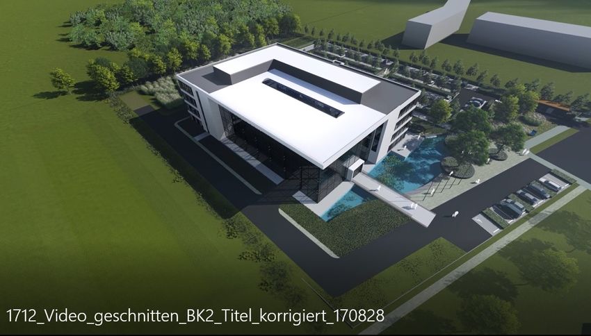
R. Clausen: BIM in Landscape Architecture: A Report                                         357

digital data. Even for industrial projects in various expansion levels, the only data available
on supply lines are those which were prepared digitally during recently preceding projects.
The information thereby often comes from measurements made when the lines (or pipes)
were being laid. Even this data cannot be converted into information models without an ex-
tensive post work-process, which would then become the starting point for expansions, mod-
ifications, and additions. The effort it takes for such data processing cannot be covered with
normal fees.
Most landscape architects are not involved in planning larger pipeline systems. However,
when working on a BIM project, it may be necessary to get connected with these networks
in order to be integrated in the entire project. It is necessary to work with pipeline cadastral
plans also for the planting of trees to establish a coordination of supply assets and urban
planning. In these projects contract rules have to be established and regulations should be
made to enable working with BIM. Often, after naming the effort it would take, the BIM
planning method is not integrated into the work process. This however is all the more pref-
erable than not having the work properly rewarded.
Terrain data make particularly high demands on integration into a coordination model. For
instance, when creating digital terrain models, considerable amount of data is quickly gener-
ated, which can overload even high-performance systems if the data required for further pro-
cessing is not filtered out for its integration into the coordination model.
Data from vegetation which is recorded in a registry should be integrated into BIM projects,
especially if the data is to be used permanently for property management. If the results of tree
inspections are integrated, specifications concerning maintenance and renewal measures can
be derived from this data. These measures can be documented and kept up-to-date by entering
information from regular controls. Information concerning aspects of protection of species,
e.g., endangered species dwelling in trees discovered during the course of maintenance or
from maps and documents can also be integrated into the BIM model. Because of this, the
database of the BIM model will become more and more valuable over the years, as a need
for action as well as developments can be derived and effectively planned by recognizing
long-term observations. Thereby, an economic planning of measures can be carried out for
inventory development instead of merely reacting to sudden events. Thus far, such questions
have been dealt with more often in a GIS environment. For an effective management of a
number of complex buildings and open spaces, the database can be merged more compre-
hensively in a BIM environment. This is possible because all aspects of management can be
taken into account and not only those related to vegetation.

4     Data Management, Interfaces, Programs (4d, 5d)
The success of the work process with BIM depends on the handling and exchange of data
with the BIM coordinator in the coordination model with the direct cooperation of other par-
ticipating planners. On the one hand, missing data can lead to planning errors, clashes and a
load of unnecessary work while planning, and on the other hand, an excess of data or unfil-
tered transfer generated during its development can make the coordination model slow
thereby frustrating the partners.
It makes no sense to integrate all data which are generated in the course of the work process
into a coordination model because not all of them are relevant for further planning. The tri-
angular prisms data of digital terrain models are usually quite bulky but are not further pro-
358                                             Journal of Digital Landscape Architecture · 6-2021

cessed. Interestingly, the information on newly created surfaces of a terrain regulation can be
used by other co-planners as a reference for construction measures. During the collaboration,
the amount of run-off soil can be reduced by optimizing the process by improving soil man-
agement. This is achieved by buildings being optimally classified according to their heights,
achieving a balance of masses in the construction site. For the planning of construction pits,
foundations, infiltration systems, interpolated courses of transitions of different homogenous
areas from drilling profile can be relevant for architects, structural engineers, and landscape
architects. The selection of who needs which data and which data needs to be integrated into
the coordination model to enable joint coordination has to be aligned on a project-specific-
basis. This helps in developing an optimal workflow of the project. The landscape architect
should have the competence to coordinate with the BIM coordinator to secure this data which
is profitable for the field of landscape architecture.

5     Does Everything have to be in a Coordination Model?
Just like how data on furnishings and cable routes is hardly relevant for outdoor facility plan-
ning, the data from tree registry or other outdoor elements are hardly going to be of interest
to a structural planner. So, in case of large and complex construction projects, does it make
sense to break down BIM processing into individual models, such as construction phases,
buildings, etc.? A disadvantage for this aspect is that between these individual models, errors
and clashes could be created. But on the positive side, since different teams work on each
model separately, it enables them to interact and work together, since these teams need to be
in close communication at any rate.
These models can be merged through coordinated transfer areas between them. For example,
an “outdoor space model”, which consists of all supply’s connections in a distribution room,
yet without including the entire building. The distribution room with the corresponding sup-
ply transfer points is then included in the building model and is linked to the building’s sup-
ply-lines data as well as other building data. This is also how we as a landscape architect
company amongst others worked on a major automotive infrastructure project. In this case,
the distribution room worked like an insertion cube, which is used to insert application inter-
faces into the building model and it can be kept in every other application model. By incor-
porating standardized versions of these transition areas or insertion objects, the coordination
between each individual model can be simplified.
Generating and organizing data during all work phases and its consequent management with
BIM makes perfect sense. But this asks for technical and organizational modifications, also
when there are modifications to the work process itself to ensure economic processing (see
illustration under point 2).
It also makes sense if only some parts of the work process are based on the BIM model. In
such a case, the tasks concerning general problem solving and coordination between the part-
ners can be carried out using BIM until the end of the conceptual design phase. In landscape
architecture this is reasonable, because the cost of outdoor facilities is only a fraction of the
total budget including the technology currently available, and the complete workflow in all
phases with BIM does not seem economically depictable. Outdoor facilities are seldom de-
signed in grid structures with repetitive elements. In most buildings, small and large modules
like rooms, doors, windows, etc. are used in greater numbers. These structures along with
R. Clausen: BIM in Landscape Architecture: A Report                                          359

network and supply lines can be standardized and therefore are far better suited for a model-
based process than outdoor systems with elements that typically do not repeat themselves.
In many outdoor area designs, the characteristic elements are customized to the specific
building site. Often times, elements such as characteristic vegetation, patches, walls, sur-
rounds or edging and square spaces result more from design principles with individual shap-
ing than the mere copying of such elements. This method influences the genius loci, often
constituting the essential quality of a good plan.
Since landscape architecture always focuses on implementing something new into an envi-
ronment, the interfaces require many individual adaptations. These adaptations are likely to
require a lot of detailed work when integrating into the planning model yet are only applicable
in one individual place. Model based work should only happen in transition areas, if for ex-
ample it is indicated with the connection of infrastructure facilities, and thus being of benefit
to the operation of the facilities. Low-data areas such as lawn areas are less relevant in this
case.
In landscape architecture it is important to visualise the sequence of spaces to know how the
end result looks like. Therefore, BIM is likely to become the standard of work process, espe-
cially when landscape architects are in pursuit of the right planning approach in coordination
with the essential requirements and visualization of the given space. Videos and perspectives
are helpful for the layman who is often overwhelmed with plans and sections. Quite often,
data is used to create digital representations to bring together landscape and the building in
order to virtually comprehend the planning.
After the conceptual planning is approved by the client, the work that follows is no longer
model-based in many of our projects. The individual models within the implementation plan-
ning phase can get so complex during the course of the project, that a solely model-based
process would exceed the possibilities to achieve our goals by the process time given by the
fee amount. This includes the model-based execution of planning as well as its adjustment
with all parties involved via a coordination model. As of yet, the Companies in the “gardening
and landscaping” sector in Germany is hardly equipped for project processing with BIM, so
that in this regard a collaboration with executing companies is currently technically not fea-
sible.
This results in processing with mixed technologies (model-based in project phases 1-4, then
without BIM). This enables us to make decisions with all partners during the early phases of
the project. It is often required when continuing the planning according to previous pro-
cessing methods with the implementation planning, call for proposals and with the imple-
mentation into the actual facility together with the gardening and landscaping companies, to
work with 2D-plans without connecting to planning data. Detail plans, planting plans and
many others, we are yet able to produce more economically the conventional way directly as
a paperplan.
Data exchange with building companies concerning stacking-out, accounting and for docu-
mentation, or for information purposes and for the operation of a facility are not the standard
at present but more the exception. What is more, still a lot has to change with the project
processing inside the office until BIM will become the standard.
For this purpose, the processing effort of freely shaped, curved and twisted objects has to
become so simplified that it is as quickly manageable as horizontal projections. Then BIM
360                                              Journal of Digital Landscape Architecture · 6-2021

will become usable in all project phases within landscape architecture. Another aspect would
be an easy made connection of objects for the quantity determination to date bases, so that
newcomers can also proficiently use the data without having years of previous experience
with various software. Maybe the deduction of the planning methods from the planning areas
with more standardized content is the reason for this kind of work method not being more
economically feasible within landscape architecture.

6       An Outlook
According to the BMVI, BIM will become general standard for building projects of the fed-
eral government in Germany. Can individual processing methods be preserved by this for
long-term? Do landscape architects have to adapt to working as the “smaller” partner only or
do they have more liberty and opportunities in undertaking projects than large-scale technical
trades have? Through continuing and advanced further training of differently skilled employ-
ees, landscape architecture can influence the design and specifications of the work process
with BIM also as a small trade. This could work if we build professional competence for
model-based planning thereby having a voice in the shaping of BIM in our project. Such a
competent contribution to projects will make a difference in the way we apply and involve
ourselves.
Generally speaking, Germany also seems to be lacking a leadership role in this area of digi-
talisation as well: “Press release. More efficiency through digitalisation within the building
sector. The national centre for the digitalisation of the building sector starts its work (January
29th, 2020). The national centre for the digitalisation of the building sector “BIM Germany”
aims at a uniform and coordinated approach in infrastructure construction and building con-
struction. State secretary Dr. Tamara Zieschang (Federal Ministry of Transport and Digital
Infrastructure) and state secretary Anne Kathrin Bohle (Federal Ministry of the Interior,
Building and Home Affairs) opened the centre’s office today. It is jointly operated by both
Federal Ministries. By using the digital planning method BIM – Building Information Mod-
elling – it is expected that there is a solid data basis available over the whole life cycle of the
building. Already at the establishment of the building, this leads to more cost efficiency, high
quality and timeliness.” 2
Also, on the part of software companies, it still appears as if the planning method BIM still
has to be promoted. The transformative effect of BIM on its processes and project ap-
proaches.

Summary and Overview
“In light of the increasing amount of infrastructure projects where Building Information Mod-
elling (BIM) is applied, the knowledge spreads that only with BIM the competitiveness can
be ensured and new assignments obtained. An approach to projects based on BIM offers
many significant advantages. These could be less need for reworking, fewer mistakes, better
collaboration generally as well as layout data which can be used in retrospect to support the

2   Source: BIM Deutschland – Zentrum für die Digitalisierung des Bauwesens. Geneststraße 5, Auf-
    gang A, 10829 Berlin. Tel.: +49 30 95 99 89 560. E-Mail: info@bimdeutschland.de. https://bim-
    deutschland.de (Accessed 25/03/2021).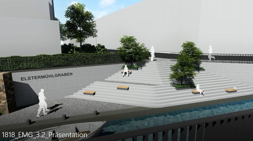
R. Clausen: BIM in Landscape Architecture: A Report 361
operation, maintenance, and property management. Clients that request infrastructural build-
ings, including public authorities, do not want to forego the advantages and increasingly de-
mand the use of BIM in their projects.” 3
7 Exemplary Projects with Images and Graphics
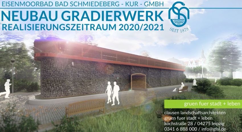
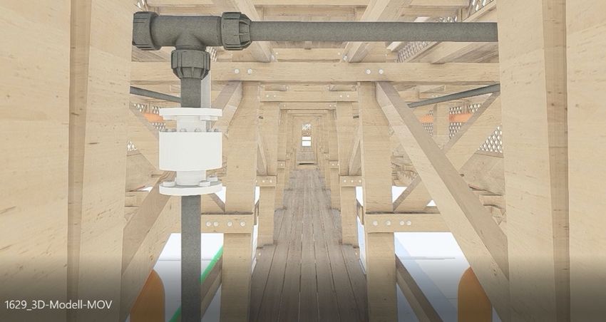
Graduation Tower
The graduation tower in Bad Schmiedeberg was developed via a 3D-model. The entire coor-
dination process including the client, approval authorities and structure planning was carried
out based on the model data. The optimisation of the structure, the integration of the technical
base and the quantity calculation for the tendering was also done model-based. After surren-
dering the model to the executing company, the corresponding plans are currently developed
from the data. The construction is planned for midyear. The soil replacement, underground
pipes and the shell construction of the brine tub were already done in 2020.
Fig. 1: Graduation tower tarpaulin
3 https://www.autodesk.de/solutions/bim/hub/bim-for-infrastructure-implementation-guide
(28.02.2021).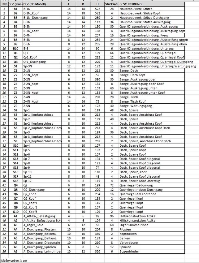
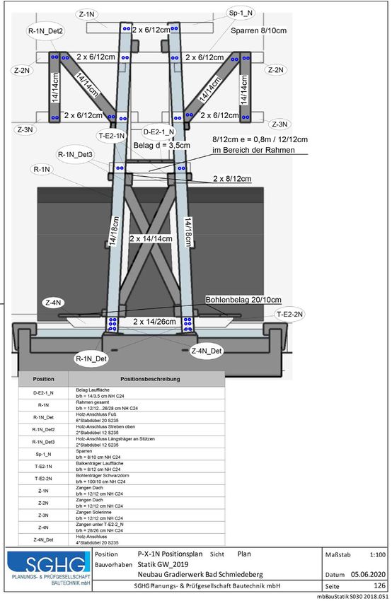
362                                           Journal of Digital Landscape Architecture · 6-2021

Fig. 2: Piping layout and interior construction, project phase no. 5

Fig. 3: Coordination basic pipework, concrete construction, wooden construction

Fig. 4: Concrete construction
R. Clausen: BIM in Landscape Architecture: A Report   363

Fig. 5: Cross-section wooden component

Fig. 6: Shuttering- and reinforcement plan
364                       Journal of Digital Landscape Architecture · 6-2021

Fig. 7: Component lists
R. Clausen: BIM in Landscape Architecture: A Report   365

Fig. 8: Statics deduced from a model
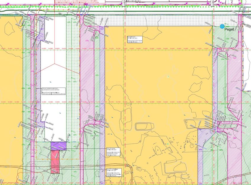
366                                           Journal of Digital Landscape Architecture · 6-2021

Goldbeck
The presentations of the outdoor installation planning was presented to the client in a video
format. The building data where hereby made available to the landscape architect to obtain a
realistic overall impression of the planned facility. After the approval of the conceptual de-
sign the project was continued without data modelling as a 2D CAD project.

Fig. 9: Bird’s eye view of rendering based on building data and landscape architecture

Fig. 10:   Forecourt and pond system perspective
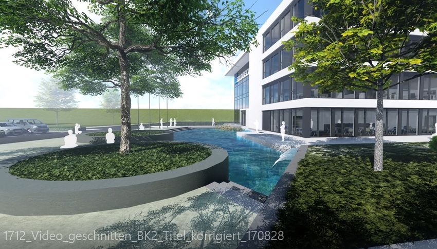
R. Clausen: BIM in Landscape Architecture: A Report   367

Fig. 11:   Cut- & Fill plan

Fig. 12:   Rough subgrade height plan
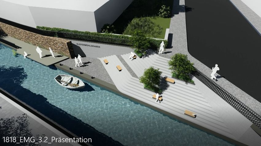
368                                            Journal of Digital Landscape Architecture · 6-2021

Kecskemét
The location development of the 2nd Mercedes Benz plant in Hungary was based on survey
data and created as a digital model. Data from the building planning, traffic management and
from infrastructural planning of the media were synchronised within the model and formed
a basis for the implementation of land levelling. About 1.5 million cubic metres of soil was
moved to make the area of the facility arable. The overall planning of the plant was realized
with BIM.

Fig. 13:   Agreements concerning route coordination

Elstermühlgraben
The inner-city former mill race in Leipzig, which over the course of the 20th century were
tubed because of the water contamination, are again brought to light during the implementa-
tion of a flood protection concept to make them visible in the cityscape. These projects serve
besides hydraulic engineering aims also urban developmental aims, where road independent
footpaths and cycle paths are integrated into the urban districts. The moats are designed in a
way that they become appealing spaces with a high quality concerning their design and a stay
in this place.
Over the course of the preliminary planning and conceptual design phase and on the basis of
the planning data of the hydro-engineering project part, the planned adjoining public areas
were developed via 3D model presentation. The coordination between the infrastructural
planning (pipelines- streets and bridges) and licencing authorities (building regulations, his-
toric preservation, environmental- and water protection) were realized without BIM, which
lead to a very high processing time within the complex variant analysis.
R. Clausen: BIM in Landscape Architecture: A Report                                 369

Fig. 14:   Perspective 1 video, project phase no. 3

Fig. 15:   Perspective 2 video, project phase no. 3

References
[1] WIKIPEDIA, Building Information Modelling.
    https://de.wikipedia.org/wiki/Building_Information_Modeling (28.02.2021).
[2] BIM DEUTSCHLAND – ZENTRUM FÜR DIE DIGITALISIERUNG DES BAUWESENS. Genest-
    straße 5, Aufgang A, 10829 Berlin. info@bimdeutschland.de. https://bimdeutschland.de
    (25/03/2021).
[3] https://www.autodesk.de/solutions/bim/hub/bim-for-infrastructure-implementation-
    guide (28/02/2021).
You can also read