RANGER: Radars and Early Warning Technologies for Long Distance Maritime Surveillance
←
→
Page content transcription
If your browser does not render page correctly, please read the page content below
RANGER: Radars and Early Warning Technologies for Long
                  Distance Maritime Surveillance
   Lazaros Karagiannidis1, Dimitrios Dres2, Eftychios Protopapadakis2, Frédéric Lamole3, François
  Jacquin3, Gilles Rigal4, Eleftherios Ouzounoglou1, Dimitris Katsaros5, Alexandros Karalis5, Luigi
       Pierno6, Carmelo Mastroeni6, Marco Evangelista6, Valeria Fontana6, Domenico Gaglione7,
      Giovanni Soldi7, Paolo Braca7, Sari Sarlio-Siintola8, Evangelos Sdongos1, Angelos Amditis1
1
  Institute of Communication and Computer Systems (ICCS), Iroon Polytechniou Str. 9, GR-15773,
                                              Athens, Greece
                    2
                      Telesto Technologies Ltd 62 Imitou Str, 15561 Cholargos, Greece
3
   Embedded Systems Dpt / HF division 5 , rue Brindejonc des Moulinais, 31506 Toulouse Cedex 5
4
  Embedded Systems Dpt / HF division Les Hauts de la Duranne, 370, rue René Descartes , 13857
                                        Aix-en-Provence Cedex 3
    5
      EXUS Software LTD, 07932357, Old Broad Sreett 25 Tower 42, London EC2N 1PB, United
                                                Kingdom
                6
                  Leonardo S.p.A. (LDO), Via Tiburtina km 12,400 - Roma - 00131 - Italy
      7
        NATO STO Centre for Maritime Research and Experimentation (CMRE), La Spezia, Italy
           8
             Laurea University of Applied Sciences Ratatie 22, 02200 VANTAA, Finland

                                                      ABSTRACT

In this paper, we present a high-level view of RANGER, a novel platform that combines innovative radar technologies
with cutting edge technological solutions for early warning, in view of delivering a surveillance platform offering
detection, recognition, identification and tracking of suspicious vessels, i.e. capabilities that exceed those of current
radar systems. The RANGER platform consists of two radar technologies, a novel Over-The-Horizon (OTH) Radar
combined with a Multiple- input and Multiple-output Radar (MIMO) implemented exploiting the latest photonics
advancements, a Uniform Communication Gateway (UCG) for seamless, secure and interoperable integration of
radars and legacy systems, an Early Warning System (EWS) exploiting data fusion and deep and adaptable machine
learning schemes able to automatically detect radar targets and produce early warnings, an Advanced User Interface
(AUI) for visualization of the maritime operational picture, and a Common Information Sharing Environment (CISE)
gateway adapter for sharing information with the CISE network. The RANGER system aims at significantly
progressing the accuracy and long distance detection, identification and recognition rates as well as improving the
provision of early warnings and alerts related to maritime operations, thus drastically improving the response and
intervention capacity of related European services.
Keywords: Over-The-Horizon (OTH) Radar; Multiple-Input Multiple-Output (MIMO) radar; machine learning;
maritime surveillance; early warning system, ethics compliance

                                               1. INTRODUCTION
Maritime surveillance and, more generally, the monitoring of the maritime traffic in the Exclusive Economic Zone
(EEZ) are today of critical importance, especially for the Mediterranean Sea that concentrates 25% of the global traffic
and is subject to critical situations and irregular activities. With the vital importance of maritime trade to the integrity
of the global economy, maritime security remains of great interest. Widespread criminal trafficking, piracy, and
terrorism threaten infrastructure, vessels and supply chains within this vast environment. As a consequence, navies and
coast guards are adapting themselves to confront asymmetric and criminal threats in the support of their pivotal role in
helping to ensure maritime security, which proves to be an increasingly challenging task.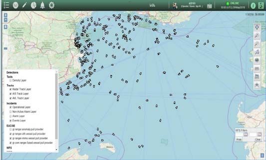
Traditional watch-keeping methods including visual observation; the use of audible warnings such as foghorns, bridge-
to-bridge Very High Frequency (VHF) radio communications; and radar (including the Automatic Radar Plotting Aid)
have all improved over the years but still suffer from lack of accuracy and time delays due to limited detection range.
A brief look at previous or existing systems shows that most mature civilian systems have been developed and used for
oceanographic applications (e.g. current studies). Some experimentations for ship detection have however been
performed without leading though to a general operational use for maritime traffic surveillance. Evaluation of HFSW
radar system [1] [2] for this purpose has shown that it has a limited range when applied to small ship detection (100 to
150 km) and their robustness to sea and ionospheric clutter and jamming are not demonstrated although essential for
small ship detection.
The majority of the modern HFSW radars are actually derived from an architecture originally designed by D. Barrick
[3] at the end of the 70s. The main improvements performed in the last years have been made to waveform (updated to
well-known FMCW modulation) or antenna shapes. Recently, Onera, with the collaboration of Pierre & Marie Currie
University, studied on improving the excitation of the surface wave and reducing the self-perturbation generated by
sky wave propagation [4] but still at an low Technology Readiness Level (TRL). Therefore, the aforementioned
systems suffer from a number of which make them unsuitable for effective maritime traffic monitoring with current
challenges (ie small boats), thus dictating disruptive technologies and approaches.
It is therefore imperative to exploit current and emerging technological advancements in view of providing the
appropriate tools that, when combined with existing and legacy systems will be able to lead to significant reduction of
the loss of lives at sea, a better control of irregular maritime traffic, while safeguarding internal security by preventing
cross-border crime such as trafficking and smuggling.
In this context, the European project RANGER [5] innovates by combining novel and ground-breaking radar
technologies with innovative supporting technological solutions for early warning, in view of delivering a surveillance
platform that will offer detection, recognition, and identification as well as tracking of suspicious vessels capabilities
far beyond existing legacy radar systems, seamlessly fitting and contributing to the Common Information Sharing
Environment (CISE) framework through the provision of on-demand CISE compliant services.
In this paper, we present a high-level view of the RANGER system, concept, overall architecture and main
components. The remainder of the paper is structured as follows: Sec. 2 presents an overview of the RANGER system,
followed by a description of the RANGER radars (Sec. 3) and its Core Platform modules; Early Warning System,
Uniform Communication gateway, Advanced User Interface, CISE translation gateway (Sec. 4). Sec. 5 briefly presents
the RANGER Ethics compliance framework, and Sec. 6 concludes the paper.

                                    2. RANGER SYSTEM OVERVIEW
The RANGER system architecture follows a modular approach supporting seamless integration of radar solutions,
interoperability with legacy systems, enhanced situation awareness and usability. The RANGER system is composed
of the following elements:
The Over-the-Horizon (OTH) radar is a HFSWR system that has the ability to detect targets at very large ranges,
beyond the horizon (several hundreds of kilometers), vessels above 10 m length.
The Photonics Enhanced Multiple-Input Multiple-Output (PE-MIMO) radar is an innovative system that supports the
OTH radar for detecting targets (
The CISE translation gateway enables the integration of the CISE compliant RANGER services (OTH radar track
service, the PE-MIMO radar track service and the RANGER EWS service) with the CISE network.
The Advanced User Interface (AUI) is the standalone user interface and front-end of the RANGER system. It displays
the different tracks from RANGER data sources (OTH, PE-MIMO, AIS, Legacy System) as well as alerts and
notifications from EWS, and will give the possibility to an operator to see information on a selected track.
The functional architecture of the RANGER system is depicted in Figure 1, and illustrates the various functional
elements of the RANGER system: the sensing elements (OTH radar, PE-MIMO radar, AIS, Legacy Systems), the core
platform (EWS, Data Fusion, Machine Learning), the RANGER gateways (UCG and CISE translation gateway), and
the front-end and user interface (AUI).
Security as a non-functional requirement of the RANGER system design spans through all the layers of the RANGER
architecture and covers physical infrastructure protection, perimeter and network security as well as user and data
security.

                                  Figure 1: RANGER Functional Architecture

                                          3. RANGER RADARS
3.1 Over-The-Horizon (OTH) Radar
The OTH radar system architecture, proposes new waveforms, processing methods and antenna concepts to meet the
challenges that are imposed by High Frequency Surface Wave Radars (HFSWR). It is built on a bi-static architecture
as illustrated in Figure 2.

                                    Figure 2: HFSWR Bi-static Architecture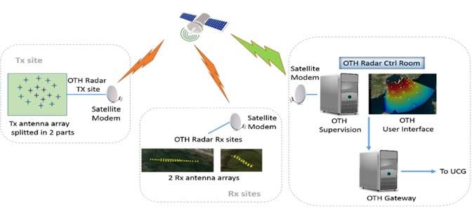
The system consists of a Transmission Site (divided into two frequencies) and a Reception Site (with 2 antenna arrays
allowing the multiplicative principle for both frequencies) located close to the shoreline.
Evaluation of the performance is realized during two pilot demonstrations in two different countries, each one
dedicated to specific criteria measurement:
In the Gulf of Lion, south of France, the radar is optimized to detect small dimension boats (and/or of weak Surface
Radar Equivalent) within long range. The performance is optimized for maximum efficiency; this is accomplished
through numerous transmitting antennas, and a stronger transmission power level.
In Greek archipelago, the radar is demonstrating the ability to be integrated as a deployable system on remote areas
and capable of taking into account the « mask » provided by the islands. The performance is optimized for
detecting and tracking vessels masked by the islands on quite shorter distances.
In both cases, it is possible to derive specifications in range, size of boat, alarm rate, and other parameters. In order to
address these objectives, diverse factors are taken into account:
Use of a secondary transmission frequency which allows simultaneously:
o To move the interference masks due to the reflectivity of the sea and the ionosphere, producing pertinent
information for detection
o To provide complementary information on the Surface Radar Equivalent of small sized boats.
An antenna network development based on the multiplicative principle allowing to improve performances:
o By reducing ionospheric disturbances
o By increasing resolution
o By handling both frequencies
An adjustment in the digitalization means in order to simplify the developments, the validation, and the system’s
deployability.
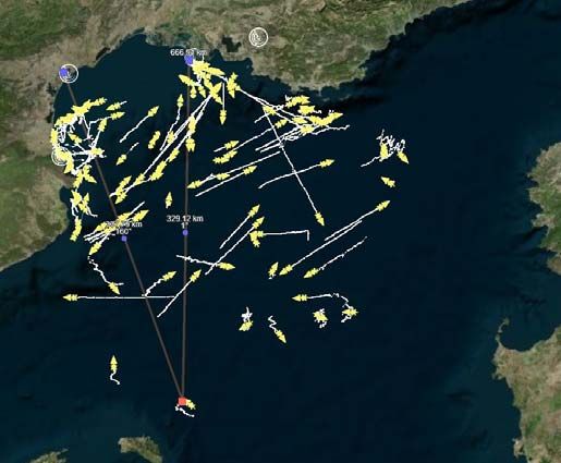
With these new waveforms and new technical concepts, the coverage exceeds 150 Nm with limited power (500 W)
and provides detection capability for vessels over 10m in length. Figure 3 depicts a typical coverage map of the OTH
radar that visualizes different tracks of vessels.
The OTH detection capabilities during the 2nd French Pilot, with only a sum of 300 W, as amplifiers power output
splitted on 10 transmitting antennas, are up to 230 km (125 NM) for the smaller vessels (between 10 m and 30 m
length) and above 320 km (170 NM) for the bigger vessels (above 30 m length) or beyond for some cases, with a
detection ratio of 90%.
Figure 3: HFSWR coverage map3.2 Photonics Enhanced - Multiple-input Multiple-output (PE-MIMO) Radar A short range PE-MIMO radar providing very high resolution in the range (
performances, in term of strong Phase Noise reduction, of Photonic Oscillators with respect to conventional electric
approaches are due to the high Q cavities realized by using very long and very low loss optical fibers.
4. RANGER CORE PLATFORM
4.1 Early Warning System
The EWS is the back-end of the RANGER system, and is constituted by a Data Fusion (DF) engine, a Machine
Learning (ML) module and an Early Warning Engine. It is responsible to store the incoming data, to fuse the detected
events from different sources (OTH and PE-MIMO radars, legacy systems), to correlate these events with the machine
learning data and to provide early warnings and alerts.
4.2 Data fusion
The main role of the data fusion module is to take all the available measurements at a particular time step, say t, that
could be measurements from different sensors (OTH radar, PE-MIMO radar, AIS data, measurements from existing
legacy systems), and fuse them in order to obtain a set of tracks (routes) related to the targets present in the maritime
scene. Two sequential tasks are performed to extract the tracks: data association and hybrid tracking.
The data association is required because of the uncertain origin of each measurement: indeed, in a region with multiple
targets, as the one that RANGER is expected to deal with, it is not known if a measurement has actually originated
from a target and, even if it was, which target generated it. The data association module takes the available
measurements at each time step, t, and associates them to each of the already existing tracks (measurement to track
association, M2TA). The measurements which are not associated to any of the existing tracks, can be either false
alarms, due to sea-clutter or interference, or generated by recently detected targets and therefore used to initialize new
tracks. RANGER uses a probabilistic data association approach, therefore allowing a level of uncertainty.
The hybrid tracker, given the result of the data association and some prior knowledge about existence and location of
the targets at the previous time step, t-1, updates their status by means of filtering techniques based on Kalman
filtering or more general particle filtering. In literature, several algorithms and methodologies have been presented for
multi-sensor multi-target tracking for maritime surveillance, e.g. [8]. Recently, a Bayesian approach method for multi-
sensor multi-target tracking based on the belief propagation (BP) scheme has been proposed [9]. It combines good
performance with an attractive scaling of computational complexity. It allows estimating adaptively unknown
environmental or model parameters, as, for example, the probability of detection of the targets [10]. Extensions to
these works will be considered for the Data Fusion module.
The Key Perfomance Indicators used to evaluate the performance of the Data Fusion module are listed in the following
table:
Table 1: KPI of Data Fusion Module
Name Description Value
Fraction of time (expressed in percentage) for which a
target is successfully tracked. For example:
Time-on-Target (ToT) 0 % : the target is not tracked at all. > 60 %
100 % : the target is tracked for its entire lifetime.
Track Fragmentation (TF) Number of fused tracks associated to a true trajectory. ≤6
For the 1st RANGER French Pilot conducted off the shore of Marseille on October 16th 2018, an average ToT of 60%
and a TF value of 3.2 were obtained during real-time operations. However, by processing offline all the measurements
(comprising the ones not processed due to network/communication issues), an average ToT of 67.2 % and an average
TF value of 2.2 were obtained.
4.3 Machine learning
The Machine Learning (ML) module operates using data from multiple data sources, as they are provided by the DF
module. As the name implies, ML module employs various machine learning methods to derive conclusions about the
characteristics of the detected/tracked vessels. Vessel characteristics are, first and foremost, related to vessel type/size,as well as more sophisticated aspects (e.g. with regard to vessel behavioral patterns, common routes). ML has three
main subsystems:
Outlier detector, which detects differentiation from the norm by comparing the last 5-minute values for a ship,
against all the others.
Length estimator, which categorize the ship’s length in one out of 5 predefined length categories.
Statistical anomaly capturing, which is a generic system allowing for specific condition violation. The conditions
are provided by the local authorities and require the track history of a ship to be calculated.
Outlier detection is a combination of stacked autoencoders (SAs)[11] and density-based clustering, using OPTICS
algorithm. The SAs are responsible for the non-linear dimensionality reduction. The OPTICS algorithm uses as input
the SAs outputs and compares ships’ patterns [12]. An illustration on how the outlier detection scheme works, can be
found in Figure 5. Length estimation constitutes a traditional multi-class classification problem. We have set a number
of classes and the length range for each of these classes. Given a set of n past fussed data files, we use four values, i.e.
longitude, latitude, speed and course as input to the classifier. The output is the corresponding class. The class (length)
is estimated using five categories: i) 25
meters. A set of seven different types of classifiers were evaluated for the suitability on length category estimation,
namely: Classification trees, discriminant analysis, k nearest neighbors, naïve Bayes, support vector machines and
their ensembles[13]. Despite the relatively small length sizes, i.e. four out of five categories are below 25 meters, an
ensemble of three classifiers, using five-minute track history, provides an average of 60% in F1 score. Classification
tree ensemble provided the best performance compared to other classifiers, and is used by ML module.
Figure 5: Outlier detection illustration: for the specific moment one ship, out of 90, has significant differences to its behavior
compared to the next closest ship.
Last, but not least, variations compared to user-imposed standards are examined by the statistical anomaly capturing
module. Any outcomes are forwarded to rule engine, and support the alert activation by the Early Warning Engine.
4.4 Early Warning Engine
The Early Warning Engine (EWE) is the core component of the EWS and its main functionalities are the generation of
alerts (e.g.: Navigation in restricted area, High absolute speed, Unknown origins and others) and warnings based on
predefined though configurable rules and to operate as the communication layer of the EWS. The maritime rules that
indicate anomalies or abnormal behavior on see, have been identified with the assistance of the RANGER platform
end users (operators) by providing a set of parameters and conditions that are fully modifiable through the Rule
Engine. The Rule Engine processes data coming from the Data Fusion and Machine Learning modules and is capableof applying rules simultaneously on various data streams, regardless of the communication protocols. The definition of
time windows for the incoming data, the filtering of data and finally the queries between incoming data streams are
features of the Rule Engine that enable the complex processing of the incoming events. The output of the rule
application is fed to the Alert Component which stores the created alerts internally and shares them either with the
AUI, in a standalone mode, or with the CISE translation gateway (through the CISE translation gateway).
4.6 Uniform Communication Gateway
The Uniform Communication Gateway (UCG) is the main gateway link between RANGER project’s Radar sensors,
Legacy systems and AIS Systems with the Early Warning Engine (EWE) and the Advanced User Interface (AUI). It is
responsible to collect and merge heterogeneous data into a common and comprehensive picture to be shared among all
relevant parties of the RANGER platform.
In other words UCG is the interoperability layer of the RANGER platforms facilitating the seamless integration of
various maritime related data sources. This includes also satellite data from Copernicus Marine Environment
Monitoring Service[14] such as significant weights height and other forecast data that are of interest in maritime
surveillance and search and rescue operations. The UCG implementation is based on the Inter VTS Exchange Format
(IVEF) service. IVEF is an ongoing standardization effort by a large group of industrial members of IALA which
intends to provide a common framework for the exchange of information between shore-based e-Navigation systems,
such as VTS systems, eNavigation stakeholders and relevant external parties[6]. Several IVEF servers and clients can
be implemented, depending on the data sources and the ICT implementation. In RANGER the UCG translated and
merges the data, while IVEF servers and clients have been implemented for sharing data with the EWE and the AUI.
Furthermore, a standalone UCG Web Interface and Dashboard is implemented for the control and management of the
UCG, the Copernicus satellite data, as well as display of health status information of the active processes, the
collection of real time statics of message data flows, data traffic load and volume. Figure 6 illustrates the functional
architecture of the UCG (left side) and the dashboard with the real time data traffic statistics.
Figure 6: UCG Functional Architecture and Dashboard
4.7 Advanced User Interface (AUI)
The RANGER AUI is a component specifically designed to provide multiple categories of users with the
functionalities required to exploit the results of both the OTH and MIMO radars, data fusion results and legacy system
information, by using the IVEF protocol and data format, which facilitates its deployment and extension for other
sensors, without requiring extensive training. This component is a map-centric Graphical User Interface (GUI)
component displaying multi-scale maps, S57 nautical charts, as well as topological information, radar cells and targets,
with level of confidence clues. Moreover, the AUI provides the capability to display the alarms defined by the Rule
Engine (EWE). Figure 7 illustrates a screenshot of the AUI where different tracks of the radars (OTH, PE-MIMO,
legacy, fused) and AIS are displayed in different colors, including information of tracks and data sources (left side), as
well as the alert panel which includes information about the early warnings and alerts.Figure 7: AUI Visual Interface and Alert Display
4.8 CISE Translation Gateway
Currently national authorities in Europe, responsible for different aspects of surveillance, (e.g. border control, safety
and security, fisheries control, customs, defense) collect data separately and often do not share them. A Common
Information Sharing Environment (CISE) is being developed jointly by the European Commission and EU/EEA
members with the support of relevant agencies[15]. This environment will integrate existing surveillance systems and
networks making different systems interoperable and giving to all the authorities concerned, the access to the
information they need for their missions at sea. CISE is a key innovation of the European maritime governance and a
key element of the European Digital Agenda; it represents a pillar of the European Action Plan for the European
Maritime Security Strategy[16] and supports the development of the Blue Economy of the European Union.
The objective of CISE is to improve maritime awareness by enhancing the maritime public authorities’ abilities to
monitor, detect, identify and track in order to better understand occurrences at sea, finding reasoned grounds for
reaction measures on the basis of combining new information with existing knowledge. In this context, it is very
important to ensure that RANGER platform is compliant with the CISE framework, in order to share the data acquired
by OTH and PE-MIMO radar with all the authorities authorized to access them.
The CISE translation Gateway includes all necessary interfaces between RANGER services and the CISE framework:
a set of services provided by RANGER are made compliant with CISE, including the individual sensor data services
(OTH and PE-MIMO services), the Fused Data service and the Alerts services generated by the Early Warning Engine
(EWE). The specific gateway is an external aggregator of interfaces to the RANGER platform to facilitate
interconnection with CISE nodes. The CISE translation Gateway allows the RANGER internal data model to “speak
the same language” of the CISE Data Model, adapting the internal transport protocol to the CISE Service Model.
Figure 8: RANGER vessels on CISE Italian Node LCLFigure 8 shows the Light Client (LCL is a CISE advanced service) of the CISE Italian Node displaying on map the
vessels received from the RANGER services as demonstrated during the second French Pilot in May 2019.
Based on the implementation of the RANGER translation gateway, RANGER is not only compatible with CISE, but it
has been also fully integrated with the operational CISE network. In particular the RANGER platform is now
configured in the CISE network as a participant of the Greek CISE node and its services are available to all the nodes
and legacy systems connected to CISE.
5. RANGER COMPLIANCE FRAMEWORK AND ETHICS
RANGER needs to take into consideration legal, ethical and societal dimensions, since only ethically sustainable
solutions are viable in the long run. Ethics as part of this compliance framework can serve as a practical angle for
engaging the ways in which security is produced. However, ethics should be seen as a way of putting critiques to
work, not just as a legitimizing function of “ethics approval”[17] .With such critical ethics approach we are seeking to
maximize the benefits of RANGER and to prevent and minimize its ethical risks. Both desk-top studies and workshops
have been used in the data collection and analysis of this ethics work, including also Societal Impact Assessment
(SIA).
Fundamental European values and norms expressed in international and European law as well as various ethical
questions raised by the end-users and other stakeholders establish the value base of the RANGER ethical requirements
and the RANGER Code of Conduct. The principles touch the totality of ethical and societal considerations of the
RANGER solutions: the technology, how this technology will be used, as well as the whole RANGER business
model/procurement as part of the European Maritime Surveillance ecosystem.
The biggest ethical challenge concerns the use of RANGER in the border control. This is related to the tensions
between humanitarianism and security. On the other hand, this is not only a challenge for RANGER, but for the whole
EU maritime surveillance policy and practices which - according to several scholars - are more focused on safety,
technology and security businesses than on human rights and saving lives.
RANGER’s impact on the wildlife and humans is a third ethical issue which emerged especially during the initial
societal impact assessment workshops organized as part of this deliverable work. Regardless of whether the impact on
wildlife and humans is real or only a fear, it is ethically and societally important issue to take into account. How to
tackle these challenges concerns both the design of the RANGER technology, the location and installation of the
radars, as well as the use of the technology in various maritime surveillance activities.
Data and information poses another set of ethical questions. Privacy and protecting personal data is always a concern,
although, the current radar technology cannot capture sensitive or personal information. However, since the RANGER
data combined with other data can violate privacy and personal data protection, the adaptation the Privacy by
Design/Default, as well as proper data security architecture and data management are all essential. Also relevant are
the right way of utilizing the data, and the avoidance of leakage and misuse of that data.
6. CONCLUSION
In this paper, we presented a high-level view of RANGER, a novel platform that combines innovative radar
technologies with cutting edge technological solutions for early warning, to deliver a surveillance platform offering
detection, recognition, identification and tracking of suspicious vessels and contributing to improved Search and
Rescue operations. The RANGER system as a whole has been already fully implemented, integrated, tested and
validated in 2 pilot demonstrations in France, while another two pilot demonstrations in Greece are planned. The
preliminary results such as the detection capabilities of the OTH radar, the time-on-target of the data fusion module,
and the vessel length classification performance indicator of the Machine Learning module, as well as the RANGER
system as a whole are very promising. Some of the most challenging aspects in maritime surveillance have been
addressed; continuous long range detection and tracking, short range detection and tracking of small vessels, improved
situational awareness and early warnings provision through novel data fusion and machine learning techniques,
interoperability, seamless integration with legacy systems and compatibility with CISE, advanced visualization of themaritime picture for improved operations and decision making. All these results which will be complemented until the
realization of the last two pilot demonstrations and the final system validation create new opportunities for EU
maritime surveillance systems and operators. The RANGER system is currently being developed in the context of the
European project RANGER and is validated in 4 pilot demonstrations in Mediterranean Sea (France and Greece), in
real operational environment.
ACKNOWLEDGMENTS
The research leading to these results has received funding from the European Commission’s H2020 research and
innovation program RANGER, under grant agreement no 700478.
REFERENCES
[1] H. J. Roarty, E. Rivera Lemus, E. Handel, S. M. Glenn, D. E. Barrick, and J. Isaacson, “Performance Evaluation
of SeaSonde High-Frequency Radar for Vessel Detection,” Marine Technology Society Journal, vol. 45, no. 3,
pp. 14–24, May 2011.
[2] C. Hernandez, “Using HFSW radar into 21-century mexico’s navy operations,” AMSC5.
[3] L. Petrillo, F. Jangal, M. Darces, J.-L. Montmagnon, and M. Hélier, “Towards a Better Excitation of the Surface
Wave,” Progress In Electromagnetics Research M, vol. 13, pp. 17–28, 2010.
[4] N. Bourey, F. Jangal, M. Darces, and M. Hélier, “Enhancing field strength in HF propagation by using a
transition between a metamaterial and the sea,” in 2013 7th European Conference on Antennas and Propagation
(EuCAP), 2013, pp. 2680–2684.
[5] “Ranger Project,” Ranger. [Online]. Available: http://ranger-project.eu/. [Accessed: 05-Oct-2017].
[6] “Inter-VTS Exchange Format Service V-145,” IALA AISM. [Online]. Available: https://www.iala-
aism.org/product/inter-vts-exchange-format-service-145/.
[7] “V-128 Operational and Technical Performance Requirement for VTS Equipment.pdf.” .
[8] S. Maresca, P. Braca, J. Horstmann, and R. Grasso, “Maritime Surveillance Using Multiple High-Frequency
Surface-Wave Radars,” IEEE Transactions on Geoscience and Remote Sensing, vol. 52, no. 8, pp. 5056–5071,
Aug. 2014.
[9] F. Meyer, P. Braca, P. Willett, and F. Hlawatsch, “A Scalable Algorithm for Tracking an Unknown Number of
Targets Using Multiple Sensors,” IEEE Transactions on Signal Processing, vol. 65, no. 13, pp. 3478–3493, Jul.
2017.
[10] F. Meyer, P. Braca, F. Hlawatsch, M. Micheli, and K. D. LePage, “Scalable Adaptive Multitarget Tracking
Using Multiple Sensors,” in 2016 IEEE Globecom Workshops (GC Wkshps), 2016, pp. 1–6.
[11] A. Voulodimos, N. Doulamis, A. Doulamis, and E. Protopapadakis, “Deep Learning for Computer Vision: A
Brief Review,” Computational Intelligence and Neuroscience, 2018. [Online]. Available:
https://www.hindawi.com/journals/cin/2018/7068349/. [Accessed: 10-Jun-2019].
[12] E. Protopapadakis, A. Voulodimos, A. Doulamis, N. Doulamis, D. Dres, and M. Bimpas, “Stacked
Autoencoders for Outlier Detection in Over-The-Horizon Radar Signals,” Computational Intelligent and
Neuroscience, 2017.
[13] E. Protopapadakis, A. Voulodimos, A. Doulamis, S. Camarinopoulos, N. Doulamis, and G. Miaoulis, “Dance
Pose Identification from Motion Capture Data: A Comparison of Classifiers,” Technologies, vol. 6, no. 1, p. 31,
Mar. 2018.
[14] “Home,” Copernicus. [Online]. Available: http://marine.copernicus.eu/.
[15] “Integrated maritime surveillance,” Maritime Affairs - European Commission, 28-Sep-2016. [Online]. Available:
https://ec.europa.eu/maritimeaffairs/policy/integrated_maritime_surveillance_en.
[16] “Maritime Security Strategy,” Maritime Affairs - European Commission, 28-Sep-2016. [Online]. Available:
https://ec.europa.eu/maritimeaffairs/policy/maritime-security_en.
[17] M. Leese, K. Lidén, and B. Nikolova, “Putting critique to work: Ethics in EU security research,” Security
Dialogue, vol. 50, no. 1, p. 096701061880955.You can also read