Smartmet nowcast - Rapidly updating nowcasting system at Finnish Meteorological Institute - Schweizerbart ...
←
→
Page content transcription
If your browser does not render page correctly, please read the page content below
B      Meteorol. Z. (Contrib. Atm. Sci.), Vol. 30, No. 4, 369–377 (published online June 24, 2021)
       © 2021 The authors
                                                                                                                                      SPS

Smartmet nowcast – Rapidly updating nowcasting system at
Finnish Meteorological Institute
Leila Hieta∗ , Mikko Partio, Marko Laine, Marja-Liisa Tuomola, Harri Hohti,
Tuuli Perttula, Erik Gregow and Jussi S. Ylhäisi

Finnish Meteorological Institute, Finland
(Manuscript received December 17, 2020; in revised form January 27, 2021; accepted April 2, 2021)

             Abstract
             Rapidly updating nowcasting system, Smartmet nowcast, has been developed at Finnish Meteorological
             Institute (FMI) to operationally produce accurate and timely short range forecasts and a detailed description
             of the present weather to the end-users. The system produces an hourly-updated seamless 10-day forecast
             over the Scandinavian forecast domain by combining several information sources, which are 1) radar-based
             FMI-PPN nowcast 2) Rapidly-updating high-resolution numerical weather prediction (NWP) MetCoOp
             nowcast (MNWC) forecast 3) 10-day operational forecast. The combination of the parallel information
             sources is done using an optical-flow based image morphing method, which provides visually seamless
             forecasts for each forecast variable. Prior to this combination, each of these individual forecast sources are
             postprocessed in a multitude of ways. To MNWC model analysis and forecast fields of temperature, relative
             humidity and wind speed, a simple bias correction scheme based on recent forecast error information is
             applied whereas ensemble nowcasts from FMI-PPN are non-uniformly weighted using the non- member as
             the baseline. The Smartmet nowcasting system improves the quality of short range forecasts, reduces the
             delay of forecast production and frees the time of on-duty forecaster to other responsibilities.
             Keywords: nowcasting, bias correction, seamless, pySteps, blending

1 Introduction                                                               vious shortcoming of such a purely observation-based
                                                                             nowcasting system is the lack of dynamical processes in
Operative provision of timely and accurate weather fore-                     them. Therefore their quality and applicability in opera-
casts in a nowcasting scale (commonly defined as a fore-                     tive production rapidly deteriorates as the forecast length
cast with a lead time of 0–6 hours) is crucial to sev-                       extends beyond the nowcasting range.
eral societal sectors, commercial customers and to pub-                          A natural complement to purely observation-based
lic safety. The most essential feature of such nowcasting                    nowcasting systems are high-resolution convection-
system is the update interval, which needs to be as rapid                    permitting NWP models, which do include dynamical
as possible in order to capture the present state and high-                  processes. They are able to simulate the weather devel-
frequency variations of the weather. Nowcasting infor-                       opment and provide skillful forecasts also beyond the
mation can be derived using various approaches, each                         nowcasting range. The skill of these NWP model fore-
of which have their strengths and weaknesses and there-                      casts depends both on the initial state of the model simu-
fore can rarely be used alone as the basis for a mod-                        lation on the model’s dynamical core, and on the choice
ern forecast production system. Nowcasting techniques                        of physical parametrizations, but their relative impor-
and topics are more comprehensively documented e.g.                          tance varies with the forecast length. In order to pro-
by Wang et al. (2017).                                                       vide additional value compared to NWP forecasts up-
    An obvious information source for a nowcasting sys-                      dated less frequently, a skillful rapidly-updating NWP
tem are most recent observations, which can then be ex-                      model needs to both update the initial state by assimi-
trapolated forward in time using various methods to pro-                     lating the most important observation information and
vide a short range forecast. Depending on whether in-                        have dynamics that allow this initial state information to
situ or remote-based observations are used, these now-                       actually affect the forecasts (Gustafsson et al., 2018).
casts can then be provided either for a specific geo-                        The systematic errors of the NWP forecasts can be
graphical point or for a wider domain. Such extrapola-                       caused e.g. by physical parametrization, surface forcing
tion methods are well established (Imhoff et al., 2020)                      or data assimilation, but the quality of the forecasts can
and have for a long time been used operationally by                          be improved through various bias correction techniques.
various weather services (Ayzel et al., 2019). An ob-                        Kalman filter (Galanis and Anadranistakis, 2002),
                                                                             decaying average (Cui et al., 2012) or MOS (Glahn and
∗ Corresponding author: Leila Hieta, Finnish Meteorological Institute,       Lowry, 1972) are some examples of such bias correc-
P.O.Box 503 (Erik Palmenin aukio 1), FIN-00101 Helsinki, Finland, e-mail:    tion techniques which can be applied in the nowcasting
leila.hieta@fmi.fi                                                           range.

                                                                                                                         © 2021 The authors
DOI 10.1127/metz/2021/1070                                   Gebrüder Borntraeger Science Publishers, Stuttgart, www.borntraeger-cramer.com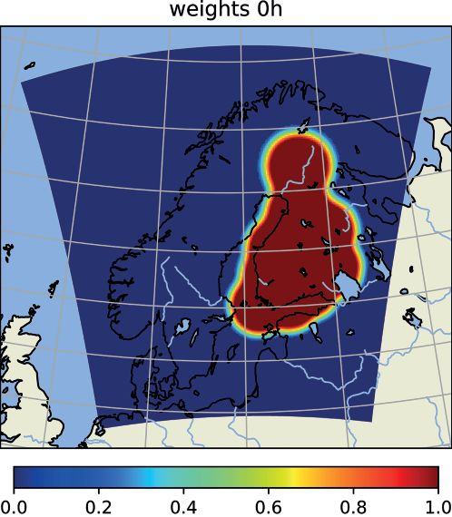
370                           L. Hieta et al.: Smartmet Nowcast at FMI                                Meteorol. Z. (Contrib. Atm. Sci.)
                                                                                                                              30, 2021

    Furthermore, as the added value of high-resolution
NWP models comes from additional and most recent
observations, the update cycle of such a model needs
to be sufficiently high. As the rapid update frequency
has a high computational burden, the forecast range of
high-resolution NWP model typically is too short for
it to serve all the needs of a forecast service provider.
For the longer forecast range, less frequently updated
models, such as Integrated Forecast System (IFS) of
the European Centre for Medium-Range Weather Fore-
casts (ECMWF) can be used. The multitude of infor-
mation sources gives a familiar dilemma for the fore-
cast provider: information source needs to be selected
based on the needs of the customer and the resulting
forecasts are mutually inconclusive. For a streamlined
production system and in order to avoid this inconclu-
siveness, these various information sources would ide-           Figure 1: Example of the gridded forecast error information for 2-m
ally form a spatially and temporally seamless forecast           temperature (in Celsius) used in bias correction. The colored area
                                                                 covers the domain of MetCoOp nowcast model and the area of the
ranging all the way from the nowcasting scale until the
                                                                 10-day operational data. The black dots represent the SYNOP station
end of the less frequently updated NWP forecast. This            locations used in bias correction
problem is very common and several alternative strate-
gies and techniques on how to merge the nowcast to the
longer forecast have been documented in the literature           terministic, data source. This 10-day operational fore-
(Sun et al., 2014; Hwang et al., 2015). Some alternative         cast data is produced by on-duty forecasters by com-
strategies are to blend the nowcast/longer-range forecast        bining the information of NWP models or statistically
data sources in each grid-point (Moisselin et al., 2019;         post-processed data e.g. Model Output Statistics (MOS)
Kober et al., 2012) or in a scale decomposition space            (Ylhäisi et al., 2017) or FMI model blend (Hieta et al.,
(Seed et al., 2013), to adjust the spatial misfit between        2020) and editing the data using meteorological Smart-
the fields (Li et al., 2005) or to assimilate the prediction     Met1 workstation. Forecasters edit the data based on
steps of the nowcast with the NWP model information              their experience to correct the model errors. The edit-
(Nerini et al., 2019).                                           ing is done mainly by using physical-based diagnostic
    The multitude of problems above are also very well           algorithms developed by forecasters. The edited 10-day
known at FMI and for that reason we have recently                operational forecast data covers the Scandinavian area
developed our Smartmet Nowcast-system (SNWC) for                 shown in Figure 1 and has a horizontal resolution of
several key forecast parameters: 2-m temperature (T2),           about 7.5 km. The 10-day operational data in this arti-
10-m wind speed (WS), relative humidity (RH) and ac-             cle refers to the forecaster edited data produced to the
cumulated 1-hour precipitation (RR). The methodolog-             Scandinavian domain, although FMI also globally pro-
ical approach of the system is to correct the spatial            duces operational forecasts.
mismatch between the nowcast and model data sources                  On-duty forecasters are editing the whole 10-day op-
using an image morphing algorithm and to form a                  erational forecast for Scandinavian domain about twice
completely new “blended” forecast data source using              a day when latest ECMWF IFS data is available. The
weighted interpolation. The motivation of this work was          nowcast range (0 h—6 h) of the 10-day operational fore-
to improve the forecast quality in the nowcasting range,         cast is edited and updated more frequently, approxi-
automate the production of hourly updating nowcast in-           mately once an hour, by on-duty forecasters by using
formation and seamlessly blend it with the 10-day op-            latest observation information. The Smartmet Nowcast
erational forecast. In this paper, we briefly describe the       system, while automated, will remove the need of short
operational production system of FMI (Chapter 2), our            forecast editing.
new Smartmet Nowcast -system with the related meth-
ods (Chapter 3), present evaluation results (Chapter 4)
and analyse how each of the previously described mo-
                                                                 2.1 Available data sources for nowcasting
tivation sources can be tackled with this system (Chap-          A limited area, convection-permitting ensemble weather
ter 5).                                                          prediction model MEPS is operated by The Meteoro-
                                                                 logical Cooperation on Operational NWP (MetCoOp)
                                                                 cooperative effort between Nordic countries (Müller
2 Operational production system                                  et al., 2017; Kristiansen et al., 2019). Also a pre-
  of FMI                                                         operational, hourly updating, deterministic MetCoOp

Most of the operational weather forecasts produced to            1
                                                                   https://en.ilmatieteenlaitos.fi/documents/30106/486066512/SmartMet_
the end-users by FMI are based on a single gridded, de-          Leaflet.pdf/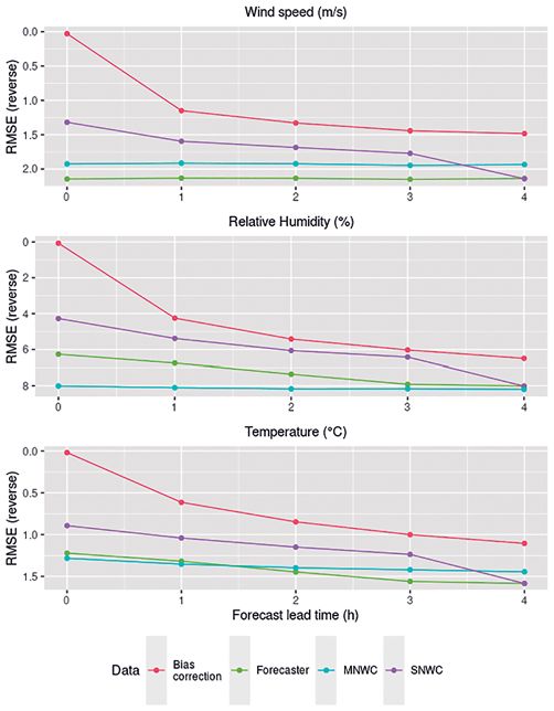
Meteorol. Z. (Contrib. Atm. Sci.)                    L. Hieta et al.: Smartmet Nowcast at FMI                         371
30, 2021

nowcast model2 (MNWC) is produced within MetCoOp
framework. The core of the MEPS and MNWC models
are based on the convection-permitting Applications of
Research to Operations at Mesoscale (AROME) model
(Seity et al., 2011). MNWC is produced for Scandina-
vian domain shown in Figure 1, the horizontal resolution
of the MNWC is about 2.5 km and the forecast length
is 9 h. The MNWC data, albeit being pre-operational, is
used as the baseline data for the Smartmet Nowcast sys-
tem.
    Surface synoptic observations (SYNOP) of 2-m tem-
perature, 10-m wind speed and relative humidity are
used in the bias correction process detailed in Sec-
tion 3.1. For wind speed observations, station-wise po-
tential wind speeds (Aaltonen and Frisk, 2019) are
used for Finnish SYNOP observation sites. It would be
easy to add non-conventional observations to the bias
correction, but we wanted to start with quality checked
operational observations.
    Accumulated 1-hour precipitation nowcast informa-
tion over Finnish radar coverage network is obtained
from Finnish Meteorological Institute Probabilistic Pre-
cipitation Nowcasting system (FMI-PPN)3 , a radar data
-based nowcast model, which is a user interface with
Python framework for short-term ensemble prediction          Figure 2: Flow diagram of the Smartmet Nowcast-system.
systems (pySteps) (Pulkkinen et al., 2019). Several
subsequent radar reflectivity or rain rate composites are
used as an input for the model, which first calculates mo-   0 h–4 h/9 h). Refining of key parameters (T2, RH, WS) is
tion field using the Lucas-Kanade optical flow method        done using a real-time bias correction scheme, whereas
(Lucas and Kanade, 1981; Bouguet, 2001). For prob-           precipitation nowcasts (RR) are acquired by spatially
abilistic nowcast calculation stochastic perturbations are   blending the extrapolation-based radar nowcasts with
applied on the input radar precipitation fields. Original    dynamical MNWC nowcasts. After post-processing of
and perturbed radar composite fields are then extrap-        nowcasts, blending them to the 10-day operational fore-
olated forward in time using backward-in-time semi-          cast is done using an image morphing technique (sec-
Lagrangian scheme described by Germann and Za-               tion 3.2). Figure 2 shows the flow diagram of the Smart-
wadzki (2002). This produces a deterministic precipita-      met Nowcast system.
tion forecast from original radar composites and a total
of 51 nowcast ensemble members from perturbed radar          3.1 Bias correction method
composites. In the end this forecast ensemble is post-       For 2-m temperature, 10-m wind speed and relative hu-
processed. The final product is a weighted average of        midity, a bias correction based on recent forecast mi-
the deterministic forecast and the mean of 51 ensemble       nus observations error information is used to produce
members where the weight of the ensemble mean grows
                                                             0 h–4 h bias corrected MNWC forecasts4 . The MNWC
over time. The optimal weights depend on season, due
                                                             model data is available after about one hour of the model
to the variations in precipitation amounts and form. Suit-
                                                             analysis time, therefore the 1 h lead time of the lat-
able weights are currently tested for different seasons,
                                                             est available MNWC is used to represent the current
but their performance is not optimized.
                                                             weather and is used to calculate the forecast error in
                                                             bias correction. The forecast error is calculated at 945
3 Smartmet nowcasting system                                 SYNOP observation station locations shown in Figure 1
                                                             by linearly interpolating the point values from MNWC
At the very heart of the Smartmet Nowcast-system is to       forecast field using 4 closest grid points. This point-wise
refine the existing information sources in the nowcast-      error information is then interpolated back to the origi-
ing range (section 3.1) through post-processing and to       nal model grid (further details in Section 3.1.1) and then
produce an hourly updated seamless 10-day operational        substracted from relevant (1 h lead time) MNWC fore-
forecast by blending the more frequently updated now-        cast grid to create 0 h field of the bias corrected MNWC
cast information with the less frequently updated 10-day     data. The error field produced is then weighted and fur-
forecast information (over a forecast length window of       ther used to produce +1 h to +4 h bias corrected fore-
2 http://www.umr-cnrm.fr/aladin/IMG/pdf/nl14.pdf
                                                             casts.
3 https://github.com/fmidev/fmippn-oper/                     4 https://github.com/fmidev/nowcasting_biascorrection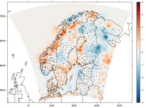
372                                      L. Hieta et al.: Smartmet Nowcast at FMI                                Meteorol. Z. (Contrib. Atm. Sci.)
                                                                                                                                         30, 2021

Table 1: Weights used in bias correction for different parameters and
forecast lead times.
   Lead time       Temperature       Wind speed      Relative humidity
   0h                   1.0               1.0               1.0
   1h                   0.9               0.9               0.8
   2h                   0.9               0.8               0.7
   3h                   0.8               0.7               0.6
   4h                   0.7               0.7               0.6

    The weights for lead times 1 h–4 h were determined
by using about one year of forecast-observation data
from 182 Finnish synoptic observation station locations.
Different weights, to correct the forecast with recent
forecast error information, were tested to each lead time
separately. The weight that produced minimum values
of root mean square error (RMSE), mean squared er-
ror (MSE) and mean absolute error (MAE) was roughly
defined as the suitable weight to use. The same obtained
weight for a certain lead time is then used for all the sta-
tion locations. An example of determining the weight for                    Figure 3: Example of determining the error weights used in bias
lead time 2 h for 2-m temperature is shown in Figure 3.                     correction for 2-m temperature and 2 hour forecast lead time. The
    The effect of different seasons was also tested but it                  data used consists of roughly one year of model forecasts and ob-
didn’t have significant impact compared to the use of                       servation data for 182 Finnish SYNOP station locations. The tested
a static weight for the whole year. Also the inclusion of                   weights are shown in x-axis and the y-axis is the value of the verifica-
error information from several past hours was tested, but                   tion metrics used. The root mean square error RMSE (black), mean
the validation results weren’t as good when compared                        absolute error MAE (blue) and mean squared error MSE (green) all
to using error information from the present hour. The                       have minimum values with corresponding error weight (W) rounded
                                                                            to 0.9.
error weights determined for different lead times and
parameters are shown in Table 1.
                                                                            information sources described in Chapter 2.1 and makes
3.1.1 Spatial interpolation                                                 a seamless forecast out of them.
                                                                                Blending methodology is illustrated by Figure 4,
The point-wise error information needs to be interpo-                       which shows the temporal development of an illustrative
lated back to the original MNWC resolution to be able to                    precipitation area in two separate forecast data sources:
produce the bias corrected model fields. For this Gaus-                     nowcast data is on the bottom and 10-day operational
sian process regression (Kriging) is used (Gelfand                          forecast data on the top. These two data sources provide
et al., 2010). The interpolation method5 uses squared ex-                   unique alternatives for each forecast length, which is
ponential covariance function with hand tuned param-                        projected along x-axis. From these two forecast sources,
eters for spatial variance and correlating range (Laine                     a blended forecast is produced through mutual weight-
et al., 2018). For the distance between points, both geo-                   ing of them. An illustration from the 10-day operational
graphical distance and altitude difference are taken into                   forecast weighting coefficient (y-axis) and its temporal
account. The land-sea mask is accounted in such a way                       development with the forecast can be seen on red dashed
that points over land areas do not correlate with points                    line. Blended forecast data follows the red dashed line
over sea areas. Figure 1 shows an example how the sta-                      and is individually generated for each forecast step by
tion specific error spreads to the neighboring locations.                   an interpolation procedure.
                                                                                Our interpolation procedure applies the same tech-
                                                                            nical methods (here namely the Farneback-method
3.2 Forecast blender                                                        described in Farnebäck (2003) from the OpenCV-
                                                                            package7 that can be used in optical flow-based radar
To produce a seamless gridded 10-day operational fore-                      extrapolation, where similar features between consec-
cast for the production, a method to smoothly blend                         utive radar images are used to derive a so-called mo-
the hourly updating nowcast data (up to 9 hour forecast                     tion vector field. Using the motion vector technique, ei-
length) to the beginning of operational 10-day forecast                     ther nowcasts can be derived by extrapolating the latest
was developed6 . Forecast blender takes in all the various                  radar images or “missing radar fields” can be derived
                                                                            in between the existing radar fields of limited tempo-
5 https://github.com/mjlaine/fastgrid/
6 https://github.com/fmidev/nowcasting_fcst                                 7 https://github.com/opencv/opencv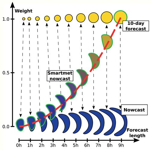
Meteorol. Z. (Contrib. Atm. Sci.)                     L. Hieta et al.: Smartmet Nowcast at FMI                               373
30, 2021

ral resolution. In this application, the same technique
used for motion vector calculation is applied for now-
cast and 10-day operational forecast fields. The result-
ing field, which is individually calculated for each of the
forecast lengths, could be called “image morphing”-field
instead of “motion vector”-field. Otherwise, the interpo-
lation procedure is similar to what is used for radar im-
ages: The weight defines how near to the 10-day oper-
ational forecast the blended forecast is when following
along the image morphing path. Here, the blended fore-
cast of the individual forecast step is the mean from the
backward (from 10-day operational forecast) and for-
ward (from nowcast) calculated image morphing trajec-
tories.
    The main code is developed such that it can be
run using several different data sources (observation-
based data for the 0 h forecast, analysis field for the
0 h forecast, extrapolated nowcast fields, dynamic now-
cast fields or 10-day operational forecast data where
blended forecast is eventually morphed to), depending
what the user has available. The code is written error-
resistant so that the only obligatory input is the 10-day     Figure 4: Image morphing principle used by the forecast blender.
forecast data source. This makes the application of it        Forecast length (weight of the 10-day forecast) dimension is pro-
                                                              jected along x-axis (y-axis) and 10-day forecast data (nowcast data)
much simpler in an operational setting: If some input
                                                              is plotted on the top (bottom). Seamless Smartmet Nowcast-data fol-
data source is temporarily missing, the forecast blender      lows the red illustrative weighting function and is individually in-
is still able to produce data for the nowcasting range        terpolated for each forecast step, using the morphing motion vectors
from the other data sources that are available. Alterna-      between the two data sources of the specific forecast length and the
tive data sources can also be used, like MEPS control         corresponding weight of it.
run instead of MNWC. The run parameter and input data
details of the blender can easily be modified and the fol-
lowing set-up is semi-operationally run at FMI:               2-meter temperature, relative humidity and
Accumulated one-hour precipitation                            10-meter wind speed

1. Analysis field (forecast length of 0 hours) is gener-      1. Analysis and 1 h–4 h forecast fields for the nowcast
   ated by spatially combining the following informa-            data are taken from bias-corrected MNWC data
   tion sources by using a spatial mask (Figure 5).
                                                              2. Hours 0 h–4 h are blended with 10-day operational
      • Accumulated one-hour precipitation from the              forecast (Figure 4).
        previous MNWC run (forecast hours 0–1) over
        Scandinavia                                           3. Weight has a value of 0 at forecast hour 0 and 1 at
      • Accumulated one-hour precipitation from the              the forecast hour 4: forecast from 4 h onwards comes
        radar observations over Finland                          from the 10-day operational forecast as such.
2. Spatial combination for the hours 1 h–4 h are gener-
   ated similarly to the analysis field, but the applied
   spatial mask is advected with the FMI-PPN nowcast          3.3 Operational scheduling
   (Figure 5).
                                                              Smartmet Nowcast-system is run hourly with 1 h tempo-
3. Spatially combined precipitation fields for the hours      ral resolution, but both the bias correction and FMI-PPN
   0 h–4 h are blended with the MNWC dynamic now-             could be run more frequently. The horizontal resolu-
   cast field (Figure 4). Weight has a value of 0 at fore-    tion of both MNWC and the bias corrected forecasts
   cast hour 0 and 1 at the forecast hour 4.                  are 2.5 km, but because of the coarser resolution of the
                                                              10-day operational forecast data, each individual SNWC
4. Spatially combined and blended precipitation fields        data source has to be upscaled onto a corresponding
   (MNWC blended with FMI-PPN for 0 h–4 h and                 7.5 km grid before blending procedure.
   direct model output for 5 h–9 h) are blended with
   10-day forecast (Figure 4).                                    We have optimized the Smartmet Nowcast-system to
                                                              reduce the delay in operational production. The bias cor-
5. Weight has a value of 0 at forecast hour 0 and 1 at        rection has a 20 min cutoff time for the observations,
   the forecast hour 9: forecast from 9 h onwards comes       within this time most of the observations are available.
   from the 10-day operational forecast as such.              The FMI-PPN radar nowcast is ready at 14 min past the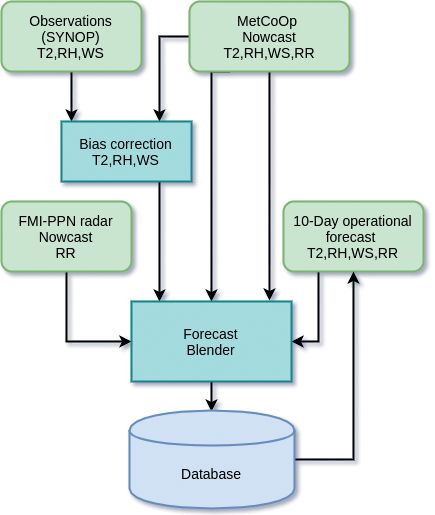
374                                L. Hieta et al.: Smartmet Nowcast at FMI                                 Meteorol. Z. (Contrib. Atm. Sci.)
                                                                                                                                    30, 2021

Figure 5: Radar coverage field for the 0 hour forecast, with the
used weighting values. Accumulated one-hour precipitation values
of the nowcast data are derived by a linear combination of the radar
measurements and the corresponding MNWC model values, using             Figure 6: Verification results of SNWC (violet), MNWC (blue),
this weighting mask for each point. For forecast time steps available   forecaster (green) and point-wise bias correction (red) for parameters
in the radar nowcast, the weighting mask is advected along with it.     10-m wind speed, Relative humidity and 2-m temperature. The data
                                                                        used in verification is from Sep 2020–Nov 2020 and the results are
                                                                        calculated to 945 SYNOP observation points in Scandinavian area.
observation hour. The post-processed nowcast informa-                   Note that the y-axes are reversed.
tion is updated each hour and further blended to the op-
erational 10-day operational forecast, which itself is typ-
ically updated twice daily (Section 2). The SNWC cycle                  to observation points. For comparison with the station
is available 25 min past the observation hour. This is sig-             observations, the gridded forecast data was linearly in-
nificantly faster than the current short range production               terpolated to the observation locations. The results are
which has a delay of about 1 h before the information is                calculated for 945 SYNOP station points in Scandina-
available for the end-users.                                            vian area and for time period of Sep 2020–Nov 2020.
                                                                        The optimal bias correction (red curve) can clearly im-
                                                                        prove the results, especially for the small lead times.
4 Smartmet nowcast evaluation results                                   The Smartmet Nowcast (violet curve) is improving the
                                                                        MNWC and outperforming the forecaster, even though
The bias correction method was developed based on the                   the upscaling and gridding are negatively affecting the
fact that it has to outperform the direct model output, but             results. The 4 h lead time of Smartmet Nowcast is al-
also the forecaster produced operational nowcasts. This                 ready fully blended to 10-day operational forecast which
was already taken into account when developing and                      can be seen from the Figure 6, but based on this short
testing the bias correction method. A thorough verifica-                verification period, the bias correction could be applied
tion of bias correction calculated to observation points                for even longer forecast lead times.
was done for different seasons during the method devel-                     Figure 7 shows a 2-m temperature time series of
opment. There is not a long time series of data avail-                  1 h forecasts for Muonio in Northern Finland. The
able to verify the gridded and interpolated SNWC out-                   MNWC model (blue curve) is capturing the rapid
put, since it has been operational only from Septem-                    changes in the temperature rather well, but the cool-
ber 2020 onwards. The Figure 6 shows the inverse of                     ing is not strong enough compared to the observations
RMSE (y-axis) for forecast lead times of 0 h–4 h (x-axis)               (black curve). The SNWC and optimal, point-wise bias
for 2-m temperature, 10-m wind speed and relative hu-                   correction (pink, red curve) are improving the forecast,
midity for Smartmet Nowcast (SNWC) compared with                        altough the SNWC is not catching the coldest values
MetCoOp nowcast (MNWC), forecaster and optimal                          probably due to the smoothing effect of the upscaling.
(no gridding and upscaling) bias correction produced                    There can also be seen a lagging in the bias corrected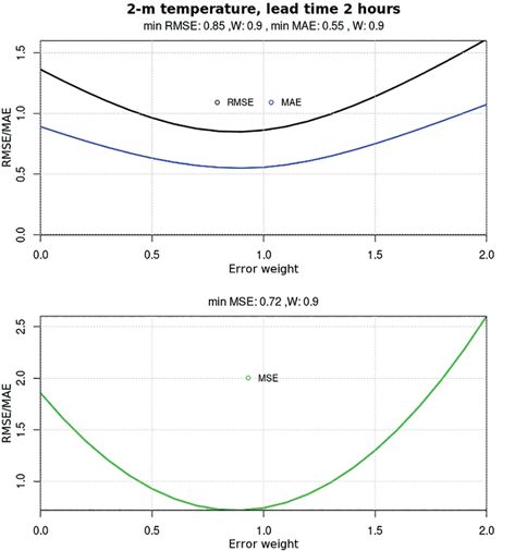
Meteorol. Z. (Contrib. Atm. Sci.) L. Hieta et al.: Smartmet Nowcast at FMI 375
30, 2021
to derive the QPE in the FMI-PPN radar based nowcast
used in Smartmet Nowcast and in the Scandinavian radar
composite shown.
There are still adjustments to be done to the method.
Even though the hourly updated radar nowcast is a real-
istic presentation of the current precipitation, the update
cycle and accumulation periods are too sparse to cap-
ture the initialisation of new convective development.
Also, information connected to light precipitation events
might end up missing.
Figure 7: A time series of 1 h forecasts of 2-m temperature for
Muonio (wmo 2823) in Northern Finland. The forecast producers 5 Discussion
shown are MetCoOp nowcast MNWC (blue), Smartmet Nowcast
SNWC (pink) and the point-wise (no gridding or upscaling) Bias There are still aspects of further development in the
correction (red) with corresponding observations (black). Smartmet Nowcast-system. An important improvement
would be the possibility to produce nowcasts with higher
horizontal and denser temporal resolution. We are cur-
rently resolving improvements to allow differing reso-
lutions for the nowcast information and the rest of the
10-day operational forecast.
Non-conventional observations could be included in
bias correction to significantly increase the amount of
observation information used. The quality control of
such observations is crucial with automated, operational
production. Bias correction could be improved by using
statistical models (machine learning). MNWC is a rather
new setup and the model is undergoing a lot of develop-
Figure 8: An example of Smartmet Nowcast SNWC accumulated ment, there isn’t a sufficient amount of data available
one-hour precipitation analysis field (0 h) and forecast times 1 h–4 h for more sophisticated statistical post-processing of the
(top panel) and respective radar QPE (bottom panel). forecasts yet. The current bias correction scheme could
be further developed e. g. by taking into account time
of the day that plays often a big role in forecast errors.
forecasts which is caused by the fact that the correction FMI-PPN is currently using information from Finnish
is using the error experienced in the previous hour. This radars, but more radar information from Scandinavian
may lead to large momentarily errors in Smartmet Now- area will be included in the near future. The MNWC
cast forecast, especially when there are rapid changes in based nowcast forecasts are now used for 0 h–4 h lead
the parameter concerned. time (except for precipitation 0 h–9 h is utilized), but the
The Smartmet Nowcast precipitation has been avail- preliminary verification results (Figure 6) suggest that a
able for forecasters since June 2020. The method has longer forecast time could be possible. Also more pa-
undergone a lot of development since summer and there rameters based on MNWC data will be added to Smart-
is still not enough reliable verification data available met Nowcast-system, after the operational nowcast pro-
to properly evaluate Smartmet Nowcast precipitation duction has been automated.
forecasts. The feedback from the forecasters has been Blending nowcast and 10-day forecast fields through
mainly positive and overall the spatial and temporal image morphing techniques also has its limitations: Both
blending of radar nowcast information with MNWC fields must be sufficiently close to each other in order for
and 10-day operational forecast is producing realistic the image morphing vectors to be meaningfully calcu-
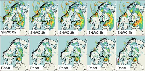
fields. Figure 8 shows an example of the Smartmet lated. Otherwise, weighting does not result as visually
Nowcast one-hour precipitation accumulation fields for seamless temporal development of e.g. lone precipita-
forecast times 0 h–4 h (upper panel) and the respective tion areas, but rather as gradual fading or “disappearing”
radar quantitative precipitation estimation, QPE (bot- of them. Hence, the method might not really be suitable
tom panel). The example shows that the Smartmet Now- for a seamless morphing of individual storm cells, which
cast produces seamless fields and the forecast of large might not be present in one of the data sources. For our
scale precipitation corresponds rather well with the radar operative forecast data with one hour temporal resolu-
observations, but the Smartmet Nowcast is unable to tion, we have however noted that the method works well
forecast correctly the new convective development seen enough. Further, we have tried several methods for the
over Southern and Central Finland. The precipitation optical flow field calculation and found the Farneback
amounts of the datasets in Figure 8 can’t be directly method providing sufficiently good quality with an ac-
compared, because different algorithms have been used ceptable calculation expense.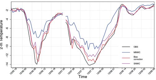
376                            L. Hieta et al.: Smartmet Nowcast at FMI                             Meteorol. Z. (Contrib. Atm. Sci.)
                                                                                                                            30, 2021

   Weights in Figure 4 follow the negative values of              Glahn, H.R., D.A. Lowry, 1972: The Use of Model
a sigmoid function and are not optimized in terms of                 Output Statistics (MOS) in Objective Weather Forecast-
performance. Rather, the weights try to preserve visual              ing. – J. Appl. Meteor. 11, 1203–1211, DOI: 10.1175/
continuity in the forecasts and take larger advantage                1520-0450(1972)0112.0.co;2.
                                                                  Gustafsson, N., T. Janjić, C. Schraff, D. Leuenberger,
of the nowcast data in the beginning of the smoothing                M. Weissmann, H. Reich, P. Brousseau, T. Montmerle,
window. Also, our “predictability” values used by the                E. Wattrelot, A. Bučánek, M. Mile, R. Hamdi, M. Lind-
forecast blender (the forecast length when weight of the             skog, J. Barkmeijer, M. Dahlbom, B. Macpherson,
10-day operational forecast reaches 1) are constant at the           S. Ballard, G. Inverarity, J. Carley, C. Alexander,
moment, whereas in reality they should be based on the               D. Dowell, S. Liu, Y. Ikuta, T. Fujita, 2018: Survey of data
current weather situation and the real-time verification             assimilation methods for convective-scale numerical weather
values of it.                                                        prediction at operational centres. – Quart. J. Roy. Meteor. Soc.
                                                                     144, 1218–1256, DOI: 10.1002/qj.3179.
                                                                  Hieta, L., M. Partio, M. Vanhatalo, J.S. Ylhäisi, M. Laine,
                                                                     2020: Experimenting Model Blend at the Finnish Meteoro-
6 Conclusions                                                        logical Institute. – In: AMS Annual Meeting Abstracts.
                                                                  Hwang, Y., A.J. Clark, V. Lakshmanan, S.E. Koch, 2015:
                                                                     Improved nowcasts by blending extrapolation and model
The focus of this work was to create a method to produce             forecasts. – Wea. Forecast. 30, 1201–1217, DOI: 10.1175/
high accuracy nowcasts with a defined presentation of                WAF-D-15-0057.1.
present weather and to automate the process of blending           Imhoff, R.O., C.C. Brauer, A. Overeem, A.H. Weerts,
the nowcast information seamlessly to the beginning of               R. Uijlenhoet, 2020: Spatial and Temporal Evaluation of
the 10-day operational forecast.                                     Radar Rainfall Nowcasting Techniques on 1,533 Events. –
                                                                     Water Resour. Res. 56,e2019WR026723, DOI: 10.1029/
    The preconditions were to find a method that is ro-              2019WR026723.
bust, fast and produces forecasts with better and more            Kober, K., G.C. Craig, C. Keil, A. Dörnbrack, 2012: Blend-
consistent quality than the current system which is based            ing a probabilistic nowcasting method with a high-resolution
on manual editing. The Smartmet Nowcast is reducing                  numerical weather prediction ensemble for convective precip-
the delay in production and outperforming the NWP                    itation forecasts. – Quart. J. Roy. Meteor. Soc. 138,755–768,
model and forecaster produced nowcast forecasts. The                 DOI: 10.1002/qj.939.
forecasters are currently using Smartmet Nowcast data             Kristiansen, J., U. Andae, H. Körnich, S. Niemelä, M. Par-
                                                                     tio, O. Vignes, 2019: The MetCoOp Ensemble Prediction
to update the operational short forecast. The method will            System for Nordic Weather Conditions. – In: AMS Annual
be automated in FMI forecast production during 2021.                 Meeting Abstracts.
                                                                  Laine, M., J.S. Ylhäisi, L. Hieta, J. Kilpinen, 2018: Efficient
                                                                     spatial interpolation of point MOS forecasts,. – Geophys. Res.
References                                                           Abstracts, EGU2018–14836.
                                                                  Li, P., W. Wong, S. Lai, 2005: RAPIDS – A New Rainstorm
                                                                     Warning System in Hong Kong. – WMO/WWRP International
Aaltonen, A., M. Frisk, 2019: Potential wind speed – homog-          Symposium on Nowcasting and Very-short-range Forecasting.
  enization of wind measurements over heterogeneous terrain. –    Lucas, B.D., T. Kanade, 1981: An iterative image registra-
  In: EMS Annual Meeting Abstracts, EMS2019–854.                     tion technique with an application to stereo vision. – Proceed-
Ayzel, G., M. Heistermann, T. Winterrath, 2019: Optical              ings of the 1981 DARPA Imaging Understanding Workshop,
  flow models as an open benchmark for radar-based precipita-        121–130.
  tion nowcasting (rainymotion v0.1). – Geosci. Model Develop.    Moisselin, J.M., P. Cau, C. Jauffret, 2019: Seamless approach
  12, 1387–1402, DOI: 10.5194/gmd-12-1387-2019.                      for precipitations within the 0–3 hours forecast-interval. –
Bouguet, J.Y., 2001: Pyramidal implementation of the affine          European Nowcasting Conference 2019.
  Lucas Kanade feature tracker description of the algorithm. –    Müller, M., M. Homleid, K.I. Ivarsson, M.A. Køltzow,
  Technical report, Intel Corporation-Microprocessor Research        M. Lindskog, K.H. Midtbø, U. Andrae, T. Aspelien,
  Labs.                                                              L. Berggren, D. Bjørge, P. Dahlgren, J. Kristiansen,
Cui, B., Z. Toth, Y. Zhu, D. Hou, 2012: Bias Correction for          R. Randriamampianina, M. Ridal, O. Vignes, 2017:
  Global Ensemble Forecast. – Wea. Forecast. 27, 396–410,            AROME-MetCoOp: A nordic convective-scale operational
  DOI: 10.1175/WAF-D-11-00011.1.                                     weather prediction model. – Wea. Forecast. 32, 609–627, DOI:
Farnebäck, G., 2003: Two-Frame Motion Estimation Based on            10.1175/WAF-D-16-0099.1.
  Polynomial Expansion. – In: Bigun, J., T. Gustavsson (Eds):     Nerini, D., L. Foresti, D. Leuenberger, S. Robert, U. Ger-
  Image Analysis. SCIA 2003. – Lecture Notes in Computer             mann, 2019: A reduced-space ensemble kalman filter ap-
  Science 2749, DOI: 10.1007/3-540-45103-X_50.                       proach for flow-dependent integration of radar extrapolation
Galanis, G., M. Anadranistakis, 2002: A one-dimensional              nowcasts and NWP precipitation ensembles. – Mon. Wea.
  Kalman filter for the correction of near surface tempera-          Rev. 147, 987–1006, DOI: 10.1175/MWR-D-18-0258.1.
  ture forecasts. – Meteor. Appl. 9, 437–441, DOI: 10.1017/       Pulkkinen, S., D. Nerini, A.A. Pérez Hortal, C. Velasco-
  S1350482702004061.                                                 Forero, A. Seed, U. Germann, L. Foresti, 2019: Pysteps:
Gelfand, A., P. Diggle, P. Guttorp, M. Fuentes, 2010: Hand-          An open-source Python library for probabilistic precipitation
  book of Spatial Statistics. – CRC Press.                           nowcasting (v1.0). – Geosci. Model Develop. 12, 4185–4219,
Germann, U., I. Zawadzki, 2002: Scale-dependence                     DOI: 10.5194/gmd-12-4185-2019.
  of the predictability of precipitation from continen-           Seed, A.W., C.E. Pierce, K. Norman, 2013: Formulation and
  tal radar images. Part I: Description of the methodol-
                                                                     evaluation of a scale decomposition-based stochastic precip-
  ogy. – Mon. Wea. Rev.130, 2859–2873, DOI: 10.1175/
  1520-0493(2002)1302.0.CO;2.
Meteorol. Z. (Contrib. Atm. Sci.) L. Hieta et al.: Smartmet Nowcast at FMI 377 30, 2021 itation nowcast scheme. – Water Resour. Res.49, 6624–664, lenges. – Bull. Amer. Meteor. Soc. 95, 409–426, DOI: DOI: 10.1002/wrcr.20536. 10.1175/BAMS-D-11-00263.1. Seity, Y., S. Malardel, G. Hello, P. Bénard, F. Bouttier, Wang, Y., E. Coning, A. Harou, W. Jacobs, P. Joe, C. Lac, V. Masson, 2011: The AROME-France convective- L. Nikitina, R. Roberts, J. Wang, J. Wilson, 2017: Guide- scale operational model. – Mon. Wea. Rev. 139, 976–991, lines to nowcasting techniques. – WMO No. 1198. DOI: 10.1175/2010MWR3425.1. Ylhäisi, J., J. Kilpinen, M. Laine, L. Hieta, L. Daniel, Sun, J., M. Xue, J.W. Wilson, I. Zawadzki, S.P. Ballard, M. Partio, M. Aalto, M. Rauhala, 2017: Model output J. Onvlee-Hooimeyer, P. Joe, D.M. Barker, P.W. Li, statistics (MOS) development at FMI. – In: EMS Annual B. Golding, M. Xu, J. Pinto, 2014: Use of nwp for now- Meeting Abstracts, EMS2017–465. casting convective precipitation: Recent progress and chal-
You can also read