Geohistorical dataset of ten plant species introduced into Occitania (France)
←
→
Page content transcription
If your browser does not render page correctly, please read the page content below
PREPRINT

     Author-formatted, not peer-reviewed document posted on 25/10/2021

             DOI: https://doi.org/10.3897/arphapreprints.e77013

 Geohistorical dataset of ten plant species
       introduced into Occitania (France)

Morgane Claudel,      Emilie Lerigoleur, Cécile Brun, Sylvie Guillerme
Author-formatted, not peer-reviewed document posted on 25/10/2021. DOI:
                https://doi.org/10.3897/arphapreprints.e77013

Geohistorical dataset of ten plant species
introduced into Occitania (France)
Morgane Claudel‡,§, Emilie Lerigoleur‡,§, Cécile Brun|,‡,§, Sylvie Guillerme‡,§
   ‡ UMR 5602 GEODE CNRS-UT2J, Toulouse, France
   § LTSER Zone Atelier Pyrénées‐Garonne, CNRS, Université de Toulouse, Castanet Tolosan, France
   | Université de Nantes, Nantes, France

   Corresponding author: Morgane Claudel (claudelmorgane@orange.fr), Cécile Brun (cecile.brun@univ-tlse2.fr),
   Sylvie Guillerme (sylvie.guillerme@univ-tlse2.fr)

Abstract

Background

The original dataset presented here is the result of the first near-exhaustive analysis
performed on historical data concerning ten plant species introduced in and around
Occitania (south-western France) since 1651. Research was carried out on the following
species: Alnus incana, Buddleja davidii, Castanea sativa, Helianthus tuberosus, Impatiens
glandulifera, Prunus cerasifera , Prunus laurocerasus, Reynoutria japonica , Robinia
pseudoacacia and Spiraea japonica.

The data file contains 199 occurrence data exclusively based on historical observations
and records made between 1651 and 2004 and retrieved from 111 of the 640 literary
sources consulted. All the records are associated with a year and 61% of them have
associated spatial coordinates. Initially the EI2P-VALEEBEE research project focused on
the introduction of these species into Occitania (95 occurrences, 47.7%), but mentions
found beyond this territory - mainly in metropolitan France - are also reported.

The creation of this dataset involved five stages: (1) selection of species, (2) consultation
of historical sources, (3) recording of occurrences in the dataset, (4) dataset
standardization/enrichment and Darwin core mapping, (5) data publication. Quality controls
were conducted at each step.

The dataset is available on the platform of the Global Biodiversity Information Facility
(GBIF) at https://doi.org/10.15468/3kvaeh. It respects the internationally recognized FAIR
Data Principles (Findable, Accessible, Interoperable and Reusable).

© Claudel M et al. This is an open access article distributed under the terms of the Creative Commons Attribution License (CC BY
4.0), which permits unrestricted use, distribution, and reproduction in any medium, provided the original author and source are
credited.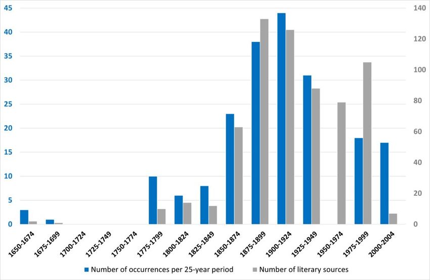
Author-formatted, not peer-reviewed document posted on 25/10/2021. DOI:
           https://doi.org/10.3897/arphapreprints.e77013

New information

The dataset will be progressively enriched by new data during the EI2P-VALEEBEE
research project and future projects on invasive plant species conducted by the team.

Introduction
EI2P-VALEEBEE is a project co-funded by the Région Occitanie and the Maison des
Sciences de l'Homme de Toulouse (cf. glossary of acronyms in Suppl. material 1). It
combines two issues of major ecological, socio-cultural and economic concern: biological
invasions and the decline of pollinator populations. The main objective of this project is to
better identify the links between plant invasions and changes in ecosystem services (Vaz
et al. 2017a) so as to better understand the potentials or constraints of invasive alien plants
in connection with pollinators and try to apprehend invasive processes through the most
systemic approach, by taking several dimensions into account and by taking strong interest
in the practices, perceptions, and representations that the various stakeholders in the
territory have manifested over time (Vaz et al. 2017b). This systemic approach is also
found in the project's method itself, since it brings together several disciplines and tools,
and also has a diachronic dimension over several time scales. In carrying out the project, it
was decided to focus on the Occitania region in the south-west part of France and, more
particularly, on two territories: the Pique valley and the Oussouet valley, both of which have
not only a high level of plant diversity but also a high rate of invasion.

General description
Purpose: The data file is the result of a geo-historical study conducted on the introduction
and distribution of invasive plant species. Ten plant species were selected that can all be
observed in the two valleys. Some of them are considered as invasive, alien species. The
study includes research on the introduction dates of the species studied, the locations of
their introduction, their interest and past uses, the different human perceptions of them
over time, activities that have impacted their local distribution, comments from authors and
observers on their abundance, and elements of the historical context of introduction.
Historical sources were consulted during 2020 in order to find the oldest elements
concerning the ten species.

Additional information: Interest and use of the dataset

Without a historical analysis, it is difficult to understand the current local distribution
dynamics of invasive plant species, especially since some of them were introduced into
Metropolitan French territory several centuries ago. All the interest of this dataset is to
provide historical depth and chronological elements for the understanding of the current

                                                     2
Author-formatted, not peer-reviewed document posted on 25/10/2021. DOI:
https://doi.org/10.3897/arphapreprints.e77013
distribution of these ten species at local scale. In this perspective, the dataset is relevant
to:
• identify the different periods of introduction of the ten species studied;
• have accurate data on the main introduction channels, such as the place where
they were introduced (mainly ornamental gardens, thermal parks, and private
gardens but also much wilder and more natural areas, such as road borders and
forests, for some of them);
• identify pathways of colonization to understand the current localization of each
species;
• better understand why they were introduced, particularly thanks to information on
their uses;
• provide elements of analysis to understand the temporal phases of species
distribution.
The interest of the dataset is directly in line with the values of the EI2P-VALEEBEE project
itself, whose objective is to contribute to better knowledge of plant invasion processes in a
transversal way. In this perspective, it can be useful for all local, national and international
organisations involved in this issue with current ecological, economic and social
implications.
Project description
Title: Geohistorical dataset of ten plant species introduced in Occitania (France)
Personnel: Conceptualization, M.C. and E.L.; methodology, M.C., E.L., C.B. and S.G.;
investigation, M.C.; data validation, M.C. and E.L.; writing, review and editing, M.C., E.L.,
C.B. and S.G.; supervision, C.B. and S.G.; project administration, S.G.; funding acquisition,
S.G.
Study area description: The Oussouet valley (Pyrenean foothills, Hautes-Pyrénées) and
the Pique valley (Haute-Garonne) in Occitania (South of France).
Funding:
• Région Occitanie - Appel à projets Recherche et Société(s) 2019
• Maison des Sciences de l'Homme et de la Société de Toulouse (MSH-T) APEX
2020
Sampling methods
Sampling description: The creation of this dataset involved a number of different stages:
(1) selection of species, (2) consultation of historical sources, (3) recording of occurrences
on the dataset, (4) dataset standardization/enrichment and Darwin core mapping, (5) data
publication.
3Author-formatted, not peer-reviewed document posted on 25/10/2021. DOI:
https://doi.org/10.3897/arphapreprints.e77013
Step 1: Species selection
Current field observations were made particularly in the two valleys selected in the south-
west of France: the Pique valley and the Oussouet valley. These two territories present a
high rate of plant invasions. Four exotic plant species were initially observed to provide
some spatial coverage in these valleys: Buddleja davidii, Impatiens glandulifera,
Reynoutria japonica and Spiraea japonica. According to the scientific needs of the EI2P-
VALEEBEE project, six species (Alnus incana, Castanea sativa, Helianthus tuberosus,
Prunus cerasifera, Prunus laurocerasus and Robinia pseudoacacia) were added to the
selection on the basis of the main relevant criteria (see glossary for acronyms in Suppl.
material 1):
• a lack of reference data in the existing literature at the national and/or local level
(CBNPMP, GBIF, IUCN, Catalogue of Life, INPN, Tela Botanica BDTFX, Baseflor
DB- Ph. Julve, Invasive Species Compendium CABI ISC, Delivering alien invasive
species in Europe, DAISIE);
• the distribution of the species in Occitania (Human observations, GBIF);
• their current status (Muller 2004, CBNPMP, GBIF, IUCN);
• the most frequently occurring species in the south-west of France (Planty-Tabacchi
1997);
• the current knowledge on their honey and nectar potentials (FranceAgriMer, the
ITSAP, the Ministry of Agriculture and Food, the SNHF, Astredhor and the VAL'HOR
inter-professional association, in partnership with the INRA, the CNPAIM, the GNIS
and the SBF).
Step 2: Consultation of historical sources
For the consultation of historical sources, a funnel method was applied:
1. To begin, the existing sources of naturalist data were inventoried at the national
level, such as flora (e.g. Flore de France, Coste 1906); seed catalogues (e.g.
Andrieux and Vilmorin 1783); horticultural, botanical and beekeeping newspapers
and magazines (e.g. Bulletins de la Société Centrale d'Apiculture 1856-1946,
Bulletins de la Société Nationale de Protection de la Nature 1882-1888). This first
national-scale inventory gave an idea of the presence of the ten species in France
during the different periods of history. It also allowed the written sources containing
botanical elements on a smaller scale to be identified.
2. The second stage was the analysis of literary sources at the regional level
(Occitania). Local herbariums (e.g. Bordere 1871-1872), regional flora (e.g.
Philippe 1859), botanical magazines and newspapers of the region (e.g. Société
d'Horticulture 1854-1921) were inventoried and analysed. The seed merchants and
horticulturists located in the region were also inventoried to explore their seed
catalogues (e.g. Catalogue des plantes vivaces et d'extérieur, Bonamy Frères 1874
) and potentially find elements on the colonization routes of the species. In addition,
efforts were made to be as exhaustive as possible by consulting archival
institutions at the departmental level (Departmental Archives of Hautes-Pyrénées,
4Author-formatted, not peer-reviewed document posted on 25/10/2021. DOI:
https://doi.org/10.3897/arphapreprints.e77013
Departmental Archives of Haute-Garonne). The archived documents consulted
were of all kinds: some known botanists' collections (e.g. Bouget 1901-1948),
invoices related to seed orders, documents on the construction of natural parks
(Natural Park of the Pyrenees collection, Aymonin 1975) and thermal gardens
(“Projet d’aménagement du Parc des Quinconces”, Chevalier 1902), together with
herbariums, letters and notes. Examining these references for specific information
on introduced exotic species and their spatial location was innovative.
3. Once enough regional historical sources had been analysed, it was possible to
focus on the scale of our study sites. The main idea was to study historical sources
on the scale of the municipalities located in the Pique and the Oussouet valleys.
For this purpose, municipal archives (e.g. Municipal archives of Bagnères-de-
Luchon, Municipal archives of Tarbes) were also consulted, taking care to identify
the potential pathways of introduction on a very local scale in advance, to facilitate
the search in archived articles. As local data sources, archival records enabled
consultation of communal monographs that presented a chapter on the local flora
(e.g. Barèges monograph, Rondou 1907). Finally, newspapers associated with the
municipalities (e.g. Revue de Comminges, Société des Études du Comminges
1885-2004) and local herbariums (e.g. Ramond de Carbonnières 1755-1825),
offered information on the flora that was much more local and precise.
Throughout the research process, key informants having good knowledge of the study
areas and their backgrounds contributed information and advice on valuable literary
sources, allowing the research to best fit the study areas and to be as complete as
possible. In order to consult sources of all kinds, it should also be noted that, as soon as
we felt that a literary source could potentially contribute elements on one of the ten
species, we consulted it even if, at first sight, it had no connection with botany (e.g. the
recipe book of La Varenne 1651).
As a result, during this step, 640 literary sources were consulted. Among these, 111
(17.3%) provided information on the introduction and colonization of the ten species over
time (Suppl. material 3). It must be understood that consulting historical sources was one
of the most important steps, not only in the creation of this dataset but also for its future
updates, because this work made it easier to identify potential sources of information
and distinguish them from blind alleys.
Step 3: Occurrences recorded in the data file
Each time a species was mentioned in the historical literature consulted, it was recorded in
an occurrence data file created in LibreOffice Calc (spreadsheet program). The file format
is OpenDocument Spreadsheet (.ods). When recording an occurrence, attention was paid
to the vernacular and scientific synonyms used in the historical literature. We recorded the
occurrences for which the historical name is currently identified as a synonym in the
Catalogue of Life, INPN, and ISSG but also according to the number of elements in the
bibliographic source that allowed the taxon to be identified as such: photographic
representation, image or plate of the species, precise description, mention of other known
scientific and vernacular names. In the data file, a maximum of elements mentioned by the
5Author-formatted, not peer-reviewed document posted on 25/10/2021. DOI:
https://doi.org/10.3897/arphapreprints.e77013
author were recorded: the synonym cited; the reference code from the French taxonomic
referential TAXREF (https://inpn.mnhn.fr/programme/referentiel-taxonomique-taxref?lg=en
); the bibliographic reference in which the mention of the species was found; the date of
observation of the species or, failing that, the date of its mention; the names of the
observers and authors; the type of source; the description of the location as soon as it was
mentioned; its spatial coverage and abundance; its minimum and maximum altitudes; any
comments by the author about the species, the location of observation or mention of the
species; the nearest town/village; and the latitude and longitude coordinates. In addition,
each element concerning the literature source was recorded in the same software
(LibreOffice Calc): bibliographic reference number (identifier), name(s) of the author(s),
title, year of publication, collection and publisher if they were mentioned, as well as the city
of publication, the name of the journal (if the source was an article), the URL if accessible,
or the reference of the archive document with the location of the archive institution, the call
number and the series.
Step 4: Dataset standardization/enrichment and Darwin Core mapping
The Darwin Core Standard (Wieczorek et al. 2012) "offers a stable, straightforward and
flexible framework for compiling biodiversity data from varied and variable sources. (...)
This standardization not only simplifies the process of publishing biodiversity datasets, it
also makes it easy for users to discover, search, evaluate and compare datasets as they
seek answers to today’s data-intensive research and policy questions." (source: https://
www.gbif.org/darwin-core).
Each column header of the occurrence spreadsheet was searched for an equivalent term
in the Darwin Core quick reference guide (https://dwc.tdwg.org/terms/). We also chose the
Identification History extension (https://tools.gbif.org/dwca-validator/extension.do?
id=dwc:Identification) to manage synonyms of taxon names as they were cited in the
literature consulted.
The geographic data (longitude, latitude, WGS84 datum) were structured in two ways: 1)
geographic coordinates with an accuracy of 500 metres for occurrences whose locality was
precisely identified in the literary source, 2) geographic coordinates with an accuracy of
10,000 metres for occurrences whose literary source mentioned only the name of the
municipality (https://www.geonames.org/). For each occurrence, the Darwin core terms
“country”, “province”, “county”, “municipality” and “locality” were assigned as far as possible
from the elements of the literary sources.
Step 5: Data publication
For the publication in the GBIF platform, the Integrated Publishing Toolkit (IPT (gbif.org)) of
the GBIF was used to fill out the metadata and to generate the Darwin Core Archive. The
dataset is available on the GBIF platform at https://doi.org/10.15468/3kvaeh (Claudel et al.
2021). The dataset now respects the FAIR Data Principles (Findable, Accessible,
Interoperable and Reusable) defined by Wilkinson et al. (Wilkinson 2016). Table 1
summarizes the FAIRness assessment criteria used to make the dataset FAIR.
6Author-formatted, not peer-reviewed document posted on 25/10/2021. DOI:
https://doi.org/10.3897/arphapreprints.e77013
Quality control: Several quality controls have been implemented. First, data cleaning and
corrections were performed with proofreading by a third party and the use of pivot tables to
check data integrity. Harmonization and standardization of content were also necessary to
allow and facilitate the mapping with Darwin Core terms. The latter made it possible to
identify new additional information such as nomenclatural code, coordinate uncertainty,
geodetic datum, georeference source, license, etc. As many standards as possible were
chosen to describe country codes (ISO 3166-1-alpha-2), municipality names and their
geographic coordinates (geonames.org), taxon scientific names (TAXREF v13.0 -
2019-12-06), and taxon ID from several sources (GBIF, IUCN, Catalogue of Life, IPNI,
INPN, Tela Botanica BDTFX). Finally, we used a GIS tool (QGIS 3.10 LTR) to check the
geographic coordinates of occurrences.
Geographic coverage
Description: Within the framework of this geohistorical study, we consulted the information
on the introductions and distributions of target species existing in archival sources
regarding the Oussouet valley (Pyrenean foothills, Hautes-Pyrénées) and the Pique valley
(Haute-Garonne), in Occitania (95 occurrences, 47.7%). When information concerning
other French or European territories: other parts of France (50.8%), Belgium (1%) and the
UK (0.5%), was found in the documents consulted, it was also recorded. This explains the
European geographical coverage. Of the 199 occurrences, only 122 (61%) occurrences
are precisely geolocated (municipality or 500 metre buffer). Fig. 1 shows the geolocation of
these 122 occurrences and Fig. 2a and Fig. 2b focus on the occurrences found in the
Oussouet valley and the Pique valley.
Coordinates: 42°5'52.8''N and 59°15'57.6''N Latitude; 8°36'46.8''W Longitude and
8°26'16.8''E Longitude.
Taxonomic coverage
Description: Ten plant species were studied: Alnus incana (L.) Moench, 1794; Buddleja
davidii Franch., 1887; Castanea sativa Mill., 1798; Helianthus tuberosus L., 1753;
Impatiens glandulifera Royle, 1833; Prunus cerasifera Ehrh., 1784; Prunus laurocerasus
L., 1753; Reynoutria japonica Houtt., 1777; Robinia pseudoacacia L., 1753, and Spiraea
japonica L.f., 1782. The scientific names of the ten species comply with the national
taxonomic and nomenclatural reference system for fauna, flora and fungi in metropolitan
France and overseas: TAXREF v13 (Gargominy et al. 2019). The database contains 199
records of these ten plant species. They are all angiosperms and belong to 7 orders, 8
families and 9 genera (Table 2), classified according to APG IV (2016).
For the purposes of the historical study, all the Latin synonyms identified and validated by
the national taxonomic and nomenclatural reference frame TAXREF v13 related to the ten
taxa studied were considered. During the analysis of historical documents, we also
collected all vernacular synonyms as soon as they were associated with a validated Latin
7Author-formatted, not peer-reviewed document posted on 25/10/2021. DOI:
https://doi.org/10.3897/arphapreprints.e77013
synonym (Suppl. material 2); they will help to enrich the current vocabulary designating
these species.
Temporal coverage
Data range: 1651-1-01 - 2004-1-01.
Notes: The geohistorical database includes observation and record data for the ten
species from 1651 until 2004, collected in 2020. The objective was to cover the different
periods of introduction of these ten species in Occitania. We consulted literature dating
from the 17th century, a period during which some of the species studied seem to have
been introduced in France (Helianthus tuberosus, Prunus cerasifera, Prunus laurocerasus
and Robinia pseudoacacia).
The number of occurrences collected increased from around 1800 until 1950, which can be
explained by the introduction of four of the exotic species into Metropolitan France in the
19th century: Buddleja davidii, Impatiens glandulifera, Reynoutria japonica and Spiraea
japonica, and also by an increase in the number of historical sources relating to botany and
horticulture, which facilitated the identification of mentions or observations of the species
studied. Therefore, 75% of the historical data collected is from about 1800 to 1950 (Fig. 3).
The lack of data for the 1950-1974 period could reflect the significant decrease in the
number of naturalists’ records during this post-war period.
Usage licence
Usage licence: Other
IP rights notes: Creative Commons Attribution (CC-BY) 4.0 License
Data resources
Data package title: dwca-ei2p_exotic_plants_geohistorical_occurrences_database-
v1.4.zip
Resource link: https://doi.org/10.15468/3kvaeh
Number of data sets: 2
Data set name: Darwin Core Archive Geohistorical plants occurrences
database (occurrence.txt)
Character set: UTF-8
Download URL: http://ipt.gbif.fr/archive.do?
r=ei2p_exotic_plants_geohistorical_occurrences_database&v=1.4
8Author-formatted, not peer-reviewed document posted on 25/10/2021. DOI:
https://doi.org/10.3897/arphapreprints.e77013
Data format: Darwin Core Archive format
Data format version: 1.4
Description: The Darwin Core Standard (DwC) was used to offer a "stable,
straightforward and flexible framework for compiling biodiversity data from varied and
variable sources" (https://www.gbif.org/en/darwin-core). All columns labels and
descriptions are from https://dwc.tdwg.org/terms/.
Column label Column description
id Same as occurrenceID: An identifier for the Occurrence (as opposed to a particular
digital record of the occurrence). In the absence of a persistent global unique
identifier, construct one from a combination of identifiers in the record that will most
closely make the occurrenceID globally unique. This is the primary key of this table.
type The nature or genre of the resource.
modified The most recent date-time on which the resource was changed.
language A language of the resource.
license A legal document giving official permission to do something with the resource.
rightsHolder A person or organization owning or managing rights over the resource.
institutionID An identifier for the institution having custody of the object(s) or information referred to
in the record.
institutionCode The name (or acronym) in use by the institution having custody of the object(s) or
information referred to in the record.
datasetName The name identifying the data set from which the record was derived.
ownerInstitutionCode The name (or acronym) in use by the institution having ownership of the object(s) or
information referred to in the record.
basisOfRecord The specific nature of the data record. Recommended best practice is to use the
standard label of one of the Darwin Core classes.
occurrenceID An identifier for the Occurrence (as opposed to a particular digital record of the
occurrence). In the absence of a persistent global unique identifier, construct one from
a combination of identifiers in the record that will most closely make the occurrenceID
globally unique.
occurrenceRemarks Comments or notes about the Occurrence.
recordedBy A list (concatenated and separated) of names of people, groups, or organizations
responsible for recording the original Occurrence. The primary collector or observer,
especially one who applies a personal identifier (recordNumber), should be listed first.
occurrenceStatus A statement about the presence or absence of a Taxon at a Location. Recommended
best practice is to use this controlled vocabulary: http://rs.gbif.org/vocabulary/gbif/
occurrence_status.xml
9Author-formatted, not peer-reviewed document posted on 25/10/2021. DOI:
https://doi.org/10.3897/arphapreprints.e77013
associatedReferences A list (concatenated and separated) of identifiers (publication, bibliographic reference,
global unique identifier, URI) of literature associated with the Occurrence.
eventDate The date-time or interval when the event was recorded. Not suitable for a time in a
geological context. Recommended best practice is to use an encoding scheme, such
as ISO 8601:2004(E).
year The four-digit year in which the Event occurred, according to the Common Era
Calendar.
eventRemarks Comments or notes about the Event.
locationID An identifier for the set of location information (data associated with
dcterms:Location). May be a global unique identifier or an identifier specific to the
data set.
continent The name of the continent in which the Location occurs. Recommended best practice
is to use a controlled vocabulary such as the Getty Thesaurus of Geographic Names.
countryCode A unique (preferably globally-unique) identifier for the taxon represented in the row.
Recommended best practice is to use ISO 3166-1-alpha-2 country codes: http://
rs.gbif.org/vocabulary/iso/3166-1_alpha2.xml
stateProvince The name of the next smaller administrative region than country (state, province,
canton, department, region, etc.) in which the Location occurs. Recommended best
practice is to use a controlled vocabulary such as the Getty Thesaurus of Geographic
Names.
county The full, unabbreviated name of the next smaller administrative region than
stateProvince (county, shire, department, etc.) in which the Location occurs.
Recommended best practice is to use a controlled vocabulary such as the Getty
Thesaurus of Geographic Names.
municipality The full, unabbreviated name of the next smaller administrative region than county
(city, municipality, etc.) in which the Location occurs. Do not use this term for a nearby
named place that does not contain the actual location. Recommended best practice is
to use a controlled vocabulary such as the Getty Thesaurus of Geographic Names.
locality The specific description of the place. Less specific geographic information can be
provided in other geographic terms (higherGeography, continent, country,
stateProvince, county, municipality, waterBody, island, islandGroup). This term may
contain information modified from the original to correct perceived errors or
standardize the description.
verbatimLocality The original textual description of the place.
minimumElevationInMeters The lower limit of the range of elevation (altitude, usually above sea level), in meters.
maximumElevationInMeters The upper limit of the range of elevation (altitude, usually above sea level), in meters.
locationAccordingTo Information about the source of this Location information. Could be a publication
(gazetteer), institution, or team of individuals.
10Author-formatted, not peer-reviewed document posted on 25/10/2021. DOI:
https://doi.org/10.3897/arphapreprints.e77013
decimalLatitude The geographic latitude (in decimal degrees, using the spatial reference system given
in geodeticDatum) of the geographic center of a Location. Positive values are north of
the Equator, negative values are south of it. Legal values lie between -90 and 90,
inclusive.
decimalLongitude The geographic longitude (in decimal degrees, using the spatial reference system
given in geodeticDatum) of the geographic center of a Location. Positive values are
east of the Greenwich Meridian, negative values are west of it. Legal values lie
between -180 and 180, inclusive.
geodeticDatum The ellipsoid, geodetic datum, or spatial reference system (SRS) upon which the
geographic coordinates given in decimalLatitude and decimalLongitude as based.
Recommended best practice is use the EPSG code as a controlled vocabulary to
provide an SRS, if known. Otherwise use a controlled vocabulary for the name or
code of the geodetic datum, if known. Otherwise use a controlled vocabulary for the
name or code of the ellipsoid, if known. If none of these is known, use the value
"unknown".
georeferenceSources A list (concatenated and separated) of maps, gazetteers, or other resources used to
georeference the Location, described specifically enough to allow anyone in the
future to use the same resources.
georeferenceRemarks Notes or comments about the spatial description determination, explaining
assumptions made in addition or opposition to the those formalized in the method
referred to in georeferenceProtocol.
identifiedBy A list (concatenated and separated) of names of people, groups, or organizations who
assigned the Taxon to the subject. Recommended best practice is to separate the
values in a list with space vertical bar space ( | ).
dateIdentified The date on which the subject was determined as representing the Taxon.
Recommended best practice is to use a date that conforms to ISO 8601-1:2019.
taxonID An identifier for the set of taxon information (data associated with the Taxon class).
May be a global unique identifier or an identifier specific to the data set.
scientificNameID An identifier for the nomenclatural (not taxonomic) details of a scientific name.
scientificName The full scientific name, with authorship and date information if known. When forming
part of an Identification, this should be the name in lowest level taxonomic rank that
can be determined. This term should not contain identification qualifications, which
should instead be supplied in the identificationQualifier term.
nameAccordingTo The reference to the source in which the specific taxon concept circumscription is
defined or implied - traditionally signified by the Latin "sensu" or "sec." (from
secundum, meaning "according to"). For taxa that result from identifications, a
reference to the keys, monographs, experts and other sources should be given.
kingdom The full scientific name of the kingdom in which the taxon is classified.
phylum The full scientific name of the phylum or division in which the taxon is classified.
11Author-formatted, not peer-reviewed document posted on 25/10/2021. DOI:
https://doi.org/10.3897/arphapreprints.e77013
class class
order The full scientific name of the order in which the taxon is classified.
family The full scientific name of the family in which the taxon is classified.
genus The full scientific name of the genus in which the taxon is classified.
taxonRank The taxonomic rank of the most specific name in the scientificName.
vernacularName A common or vernacular name.
taxonRemarks Comments or notes about the taxon or name.
Data set name: Darwin Core Archive Geohistorical plants occurrences database -
Identification History Supplementary file (identification.txt)
Character set: UTF-8
Download URL: http://ipt.gbif.fr/archive.do?
r=ei2p_exotic_plants_geohistorical_occurrences_database&v=1.4
Data format: Darwin Core Archive format
Data format version: 1.4
Description: The Darwin Core Identification History is an extension allowing multiple
identification/determinations of species occurrences, particularly name spellings found
in each original text. All identifications including the current one are listed, while the
current should also be repeated in the occurrence core for simple access (Source: http
s://tools.gbif.org/dwca-validator/extension.do?id=dwc:Identification). All columns labels
and descriptions are from https://dwc.tdwg.org/terms/.
Column label Column description
id An identifier for the Occurrence linked to the occurrence.txt file (same as occurrenceID). It can
be repeated as a foreign key here.
identificationID A unique identifier corresponding to the name spelling reported as found in the original text.
This is the primary key of this table.
dateIdentified The date on which the subject was determined as representing the Taxon. Recommended best
practice is to use a date that conforms to ISO 8601-1:2019. The date format here is YYYY (eg.
1694).
scientificName The full scientific name, with authorship and date information if known. When forming part of an
Identification, this should be the name in lowest level taxonomic rank that can be determined.
This term should not contain identification qualifications, which should instead be supplied in
the identificationQualifier term.
12Author-formatted, not peer-reviewed document posted on 25/10/2021. DOI:
https://doi.org/10.3897/arphapreprints.e77013
nameAccordingTo The reference to the source in which the specific taxon concept circumscription is defined or
implied - traditionally signified by the Latin "sensu" or "sec." (from secundum, meaning
"according to"). For taxa that result from identifications, a reference to the keys, monographs,
experts and other sources should be given.
vernacularName A common or vernacular name.
taxonRemarks Comments or notes about the taxon or name.
Additional information
Maintenance and future work
All data will be maintained by their creators. They will be progressively enriched by new
data during the current EI2P-VALEEBEE research project, and also during the projects that
the team will continue to conduct on invasive plant species thereafter.
The dataset is already archived and published through GBIF:
https://www.gbif.org/dataset/345820cc-a0a8-4d76-b7eb-fba85b21ad08
It will be regularly updated and versioned through GBIF.
Acknowledgements
Project title: EI2P - Espèces invasives et pollinisateurs, entre contraintes et potentiels |
VALEEBEE - VALorisation des Espèces exotiques Envahissantes et Abeilles
Funding: Région Occitanie - Appel à projets Recherche et Société(s) 2019 | Maison des
Sciences de l'Homme et de la Société de Toulouse (MSH-T) APEX 2020
This work is endorsed by the CNRS/INEE Zone Atelier Pyrénées Garonne (ZA PYGAR).
The Zones Ateliers network (RZA) is recognized by ALLENVI, as an ESFRI eLTER
(European Long-Term Ecological Research) “Integrated European Long-Term Ecosystem,
Critical Zone & Socio-Ecological System Research Infrastructure”.
We appreciated the support and precious help of Sophie Pamerlon from GBIF-France who
gave her time to enlighten us on Darwin Core mapping and the use of the Integrated
Publishing Toolkit (https://www.gbif.org/ipt). We also warmly thank the technical
evaluator of the data for his valuable advice.
References
• Andrieux P, Vilmorin P (1783) Catalogue des plantes, arbres, arbrisseaux et arbustes
dont on trouve des graines, des bulbes et du plant chez les sieurs Andrieux et Vilmorin,
13Author-formatted, not peer-reviewed document posted on 25/10/2021. DOI:
https://doi.org/10.3897/arphapreprints.e77013
Marchand Grainier-Fleuriste & Botaniste du Roi & Pépiniériste. Vilmorin-Andrieux,
Paris. URL: https://gallica.bnf.fr/ark:/12148/bpt6k6209244b.texteImage
• APG IV (2016) An update of the Angiosperm Phylogeny Group classification for the
orders and families of flowering plants: APG IV. Botanical Journal of the Linnean
Society 181 (1): 1‑20. https://doi.org/10.1111/boj.12385
• Aymonin G (1975) Itinéraire phyto-écologique des Landes du Marensin aux montagnes
de Soule. Contribution à l’étude floristique et écologique du Parc National des
Pyrénées. Fonds du Parc National des Pyrénéees. 1863 W 61. Departmental Archives
of the Hautes-Pyrénées, France. Accessed on August 19, 2020.
• Bonamy Frères (1874) Catalogue général Bonamy Frères. Construction, plan et vues
aquarellées du projet de jardin paysager et installation de la serre du Casino. 5 M 28.
Municipal Archives of Bagnères-de-Luchon, France. Accessed on September 17, 2020.
• Bordere H (1871-1872) Herbiers de Henri Bordere, membre de la Société Botanique de
France. 1 J 592; 593; 594; 595. Departmental Archives of the Hautes-Pyrénées,
France. Accessed on September 14, 2020.
• Bouget J (1901-1948) Fonds du botaniste Joseph Bouget. 149 J 109; 9; 11; 176; 182;
235; 285. Departmental Archives of the Hautes-Pyrénées, Tarbes, France. Accessed
on Septembre 14, 2020.
• Chevalier J (1902) Aménagement du parc des Quinconces. Lettre à destination du
maire de Luchon, Paris, le 2 novembre 1902. 1 O 19. Municipal Archives of Bagnères-
de-Luchon, France. Accessed on September 17, 2020.
• Claudel M, Lerigoleur E, Brun C, Guillerme S (2021) Geohistorical plants occurrences
database. Occurrence dataset accessed via GBIF.org on 2021-01-16. UMR 5602
Géographie de l’Environnement (CNRS/Université Toulouse 2). https://doi.org/
10.15468/3kvaeh
• Coste H (1906) Flore descriptive et illustrée de la France, de la Corse et des contrées
limitrophes. 3. Librairie des Sciences Naturelles Paul Klincksiek, Paris.
• Gargominy O, Tercerie S, Régnier C, Ramage T, Dupont P, Daszkiewicz P, Poncet L
(2019) TAXREF v13, référentiel taxonomique pour la France: méthodologie, mise en
œuvre et diffusion. Muséum National d’Histoire Naturelle, Paris. Rapport Patrinat. 1–
63. URL: https://inpn.mnhn.fr/telechargement/referentielEspece/taxref/13.0/menu
• La Varenne (1651) Le cuisinier françois, enseignant la manière de bien apprester et
assaisonner toutes sortes de viandes grasses et maigres, légumes, patisseries et
autres mets qui se servent tant sur les Tables des Grands que des particuliers. Chez
Pierre David, Paris, 326 pp. URL: https://gallica.bnf.fr/ark:/12148/bpt6k114423k
• Muller S, et al. (2004) Plantes invasives en France. Patrimoine Naturels, 62. Muséum
National d’Histoire Naturelle, Paris, 168 pp.
• Philippe X (1859) Flore des Pyrénées. 1. Bagnères-de-Bigorre, P. Plassot, 605 pp.
URL: https://www.biodiversitylibrary.org/page/12445645#page/8/mode/1up
• Planty-Tabacchi A (1997) Invasions des corridors fluviaux du Sud-Ouest par des
espèces végétales exotiques. Bulletin Français de la Pêche et de la Pisciculture
344/345: 427‑439. URL: https://www.kmae-journal.org/articles/kmae/pdf/1997/01/
kmae199734434534.pdf
• Ramond de Carbonnières L (1755-1825) Herbier des Pyrénées. Herbier
Ramond, CBNPMP collection. URL: https://cbnpmp.blogspot.com/p/acces-sites-et-
outils.html
14Author-formatted, not peer-reviewed document posted on 25/10/2021. DOI:
https://doi.org/10.3897/arphapreprints.e77013
• Rondou J (1907) Monographie de la vallée de Barèges par Jean-Pierre Rondou,
instituteur à Gèdre. Tome 2 Faune, flore, géologie. 339 pp. 1 J 513 /2. Departmental
Archives of the Hautes-Pyrénées, France. URL: http://www.archivesenligne65.fr/
arkotheque/navigation_facette/index.php?
f=ad65&reset_facette=1&crit1=6&v_6_1=Monographie+communale&v_6_2=Monographie+communale
• Société Centrale d'Apiculture (1856-1946) L'Apiculteur: bulletin de la Société Centrale
d'Apiculture. Société Centrale d'Apiculture, Paris. URL: https://gallica.bnf.fr/ark:/12148/
cb34378120q/date
• Société des Études du Comminges (1885-2004) Revue de Comminges. Société
des Études du Comminges, Saint-Gaudens. URL: https://gallica.bnf.fr/ark:/12148/
cb34426879z/date
• Société d'Horticulture (1854-1921) Annales de la Société d'Horticulture de la Haute-
Garonne. Toulouse. URL: https://gallica.bnf.fr/ark:/12148/cb34413079t/date
• Société Nationale de Protection de la Nature (1882-1888) Bulletin de la Société
Nationale d'Acclimatation de France. Société Nationale d'Acclimatation de
France, Paris. URL: https://gallica.bnf.fr/ark:/12148/cb345084375/date
• Vaz A, Kueffer C, Kull C, Richardson D, Vicente J, Kühn I, Schröter M, Hauck J, Bonn A,
Honrad J (2017a) Integrating ecosystem services and disservices: insights from plant
invasions. Ecosystem Services 23: 94‑107. https://doi.org/10.1016/j.ecoser.2016.11.017
• Vaz A, Kueffer C, Kull C, Richardson D, Schindler S, Jesús Muñoz-Pajares A, Vicente J,
Martins J, Hui C, Kühn I, Honrado J (2017b) The progress of interdisciplinarity in
invasion science. Ambio 46: 428‑442. https://doi.org/10.1007/s13280-017-0897-7
• Wieczorek J, Bloom D, Guralnick R, Blum S, Döring M, Giovanni R, et al. (2012) Darwin
Core: an evolving community-developed biodiversity data standard. PLOS One 7 (1):
e29715 https://doi.org/10.1371/journal.pone.0029715
• Wilkinson M, et al. (2016) The FAIR Guiding Principles for scientific data management
and stewardship. Scientific Data 3: 160018 https://doi.org/10.1038/sdata.2016.18
15Author-formatted, not peer-reviewed document posted on 25/10/2021. DOI:
https://doi.org/10.3897/arphapreprints.e77013
Figure 1.
Spatial location of the 122 occurrences having data associated with coordinates.
16Author-formatted, not peer-reviewed document posted on 25/10/2021. DOI:
https://doi.org/10.3897/arphapreprints.e77013
Figure 2.
Focus on the a Oussouet valley and b Pique valley.
17Author-formatted, not peer-reviewed document posted on 25/10/2021. DOI:
https://doi.org/10.3897/arphapreprints.e77013
Figure 3.
Number of occurrences found and number of literary sources consulted per 25-year period.
18Author-formatted, not peer-reviewed document posted on 25/10/2021. DOI:
https://doi.org/10.3897/arphapreprints.e77013
Table 1.
FAIRness assessment criteria used for this dataset.
FAIR principles FAIRness assessment criteria used
FINDABLE
• Use a DOI for the dataset attributed by GBIF.
• Use unique identifiers (UUID) for each observation occurrence.
• Make persistent metadata and datasets thanks to the deposit on the GBIF platform.
• Use the Ecological Metadata Language (EML) internationally recognized standard to
describe the database metadata and its associated projects, including standardized
search keywords.
• Use a versioning system to allow future updates.
ACCESSIBLE
• Data storage in GBIF in accordance with the guidelines for quality standards (e.g.
use of EML).
• The GBIF repository provides efficient, rich services for various uses and users.
INTEROPERABLE
• Standard vocabularies used as far as possible for some fields.
• Thesaurus used to search keywords from international thesauruses such as GEMET
including INSPIRE themes.
• Exclusive use of Darwin Core terms.
• A Darwin Core Archive offers a stable, straightforward and flexible framework for
compiling biodiversity data from varied and variable sources (source: https://
www.gbif.org/en/darwin-core).
REUSABLE
• The Darwin Core Archive facilitates the reusability of the dataset because it enables
publication in the GBIF. This compact package (a ZIP file) contains interconnected
text files and enables users to share their data using a common terminology (source:
https://www.gbif.org/en/darwin-core).
• Use an open format for the dataset (OpenDocument.ods) and open source software
to reuse it.
• EML metadata includes provenance for raw and derived data.
• This data paper explains the data processing steps, curation protocol, quality
assurance processes, methods and tools that permit long-term integrity and
understandability of data.
• The spatial/temporal/taxonomic coverage is clearly mentioned in the EML metadata
and in this data paper, as well as the CC-BY license and rules for large reuse.
19Author-formatted, not peer-reviewed document posted on 25/10/2021. DOI:
https://doi.org/10.3897/arphapreprints.e77013
Table 2.
Phylogenetic classification of the studied taxa ordered by order, family, genus and species with their
occurrences number and their hyperlink to the subsample by species on gbif.org.
Order Family Genus Species Common name Occurrences number
(%)
Asterales Asteraceae Helianthus Helianthus Jerusalem 17 (8.5)
tuberosus artichoke
Caryophyllales Polygonaceae Reynoutria Reynoutria japonica Japanese 21 (10.6)
knotweed
Ericales Balsaminaceae Impatiens Impatiens Indian balsam 53 (26.6)
glandulifera
Fabales Fabaceae Robinia Robinia False-acacia 26 (13.1)
pseudoacacia
Fagales Betulaceae Alnus Alnus incana Grey alder 7 (3.5)
Fagaceae Castanea Castanea sativa Sweet chestnut 7 (3.5)
Lamiales Scrophulariaceae Buddleja Buddleja davidii Butterfly-bush 17 (8.5)
Rosales Rosaceae Prunus Prunus cerasifera Cherry plum 20 (10.1)
Prunus Cherry laurel 20 (10.1)
laurocerasus
Spiraea Spiraea japonica Japanese spiraea 11 (5.5)
20Author-formatted, not peer-reviewed document posted on 25/10/2021. DOI:
https://doi.org/10.3897/arphapreprints.e77013
Supplementary materials
Suppl. material 1: Glossary of acronyms
Authors: Morgane Claudel, Emilie Lerigoleur, Cécile Brun, Sylvie Guillerme
Data type: Glossary
Download file (1.97 kb)
Suppl. material 2: The synonymy of the ten species (TAXREF v13 and historical
sources)
Authors: Morgane Claudel, Emilie Lerigoleur, Cécile Brun, Sylvie Guillerme
Data type: Vernacular name identified in historical literature
Download file (4.50 kb)
Suppl. material 3: List of historical sources consulted from which the dataset was
produced
Authors: Morgane Claudel
Data type: Historical sources consulted
Download file (24.52 kb)
21You can also read