Archaeological Monitoring Report - Metro West & Metro North Dardistown Depot Co. Dublin - Transport Infrastructure ...
←
→
Page content transcription
If your browser does not render page correctly, please read the page content below
Licence No: 10E410

  Archaeological
           Monitoring
                       Report

                          Metro West
& Metro North Dardistown Depot
                           Co. Dublin

       Client: Railway Procurement Agency
                Director/ Author: Kara Ward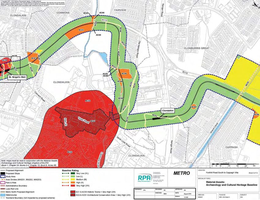
Page 2 of 49
                                                                                                  ENV-ACH-001.01
Archaeological Development Services Ltd.                                                            09 August 2011
Title: Archaeological Monitoring Report, Metro West and Metro North Dardistown Depot

                                                                                               Licence No: 10E410

                                                                           Archaeological
                                                                                       Monitoring
                                                                                               Report

                                                                                                  Metro West
                                                                      & Metro North Dardistown Depot
                                                                                                    Co. Dublin
                                                                                                  MW7166_7

                                                                                                         Client: RPA
                                                                                        Director/ Author: Kara Ward

Client:                 RPA
Contract No.:           MW7166_7
Licence No:             10E410
Location:               Metro West & Metro North Dardistown Depot,
County:                 Dublin
Fieldwork:              From October 2009 – To February 2011
Report Type:            Monitoring
Report Status:          Final
Submitted:              August 2011

                                                    ©Archaeological Development Services Ltd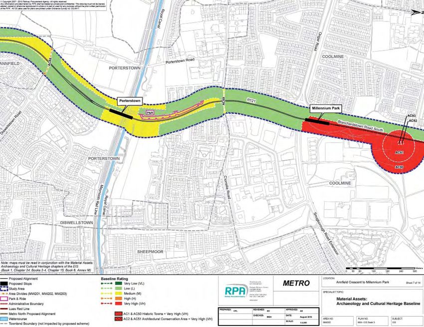
Page 3 of 49
                                                                                             ENV-ACH-001.01
Archaeological Development Services Ltd.                                                       09 August 2011
Title: Archaeological Monitoring Report, Metro West and Metro North Dardistown Depot

                                            Document History Log

  Revisio     Document         Issue Date            Description              Prepared   Reviewed     Approved
    n          Status

    01          1st Draft       17th June         Archaeological                 KW       CMcC          CMcC
                                  2011           Monitoring Report
    02           Final         5th August         Archaeological                 KW       CMcC          CMcC
                                  2011           Monitoring Report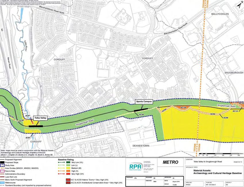
Page 1 of 49
                                                                                                             ENV_ACH_
Archaeological Development Services Ltd.                                                                  09 August 2011
Title: Archaeological Monitoring Report, Metro West and Metro North Dardistown Depot

TABLE OF CONTENTS

1.0       INTRODUCTION ............................................................................... 1
2.0       PROJECT BACKGROUND .................................................................... 2
   2.1       Metro West ............................................................................................ 2
   2.2       Metro North Dardistown Depot............................................................... 3
3.0       ARCHAEOLOGICAL, HISTORICAL AND CULTURAL HERITAGE BACKGROUND
           ..................................................................................................... 3
   3.1       Prehistoric period c.7000BC–AD400 ....................................................... 4
   3.2       Early medieval period (c.AD400–AD1100) .............................................. 5
   3.3       Late medieval period c.AD1100–AD1550 ................................................ 6
   3.3       Post-medieval period c.AD1550–AD1700................................................ 6
   3.4       Industrial Age c.AD1700–AD1900 .......................................................... 7
   3.5       RMP Sites .............................................................................................. 7
4.0       DESCRIPTION OF THE BASELINE ENVIRONMENT ................................ 12
   4.1       Area MW201: Old Blessington Road to Liffey Valley .............................. 12
   4.2       Area MW202: Liffey Valley to National Aquatic Centre (NAC)................ 13
   4.3       Area MW203: NAC to Dardistown ......................................................... 14
   4.4       Metro North Dardistown Depot Baseline environment .......................... 15
   4.5       Metro North Dardistown Depot constraints .......................................... 15
5.0       MONITORING METHODOLOGY .......................................................... 22
6.0       MONITORING RESULTS ................................................................... 23
   6.1       Metro West Results .............................................................................. 24
   6.2       Area MW201 Clonburris Great Townland .............................................. 26
   6.3       Area MW201 Irishtown Townland ........................................................ 26
   6.4       Area MW201 Ronanstown Townland .................................................... 27
   6.5       Area MW202 Coolmine Townland ......................................................... 27
   6.6       Area MW202 Corduff Townland ............................................................ 29
   6.7       Area MW203 Snugborough Townland ................................................... 29
   6.8       Area MW203 Cappoge Townland .......................................................... 29
   6.9       Area MW203 Merryfalls Townland ........................................................ 30
   6.10      Area MW203 Silloge Townland ............................................................. 31
   6.11      Metro North Dardistown Depot Results ................................................ 32
   6.12      Area MN104 Ballymun Townland .......................................................... 33
   6.13      Area MN104 Ballystruan Townland ....................................................... 36
7.0       SUMMARY OF RESULTS ................................................................... 39
8.0       DISCUSSION AND RECOMMENDATIONS ............................................ 39

               File Name: Archaeological Monitoring Report, Metro West and Metro North Dardistown Depot

                                                                                                                 1
Page 2 of 49
                                                                                                    ENV-ACH-001.01
Archaeological Development Services Ltd.                                                              09 August 2011
Title: Archaeological Monitoring Report, Metro West and Metro North Dardistown Depot

9.0 BIBLIOGRAPHY................................................................................... 39

LIST OF ILLUSTRATIONS
1.        General Location Plan
2.        Overall Route Map of Metro West
3.        Archaeology and Cultural Heritage Baseline Map-1
4.        Archaeology and Cultural Heritage Baseline Map-2
5.        Archaeology and Cultural Heritage Baseline Map-3
6.        Archaeology and Cultural Heritage Baseline Map-4
7.        Archaeology and Cultural Heritage Baseline Map-5
8.        Archaeology and Cultural Heritage Baseline Map-6
9.        Archaeology and Cultural Heritage Baseline Map-7
10.       Archaeology and Cultural Heritage Baseline Map-8
11.       Archaeology and Cultural Heritage Baseline Map-9
12.       Archaeology and Cultural Heritage Baseline Map-10
13.       Archaeology and Cultural Heritage Baseline Map-11
14.       Archaeology and Cultural Heritage Baseline Map-12
15.       Archaeology and Cultural Heritage Baseline Map-13
16.       Archaeology and Cultural Heritage Baseline Map-14
17.       Archaeological Heritage Baseline Map for Metro North Depot
18.       Architectural and Cultural Heritage Baseline Map for Metro North Depot
19.       Metro West Geotechnical Trial Pit and Borehole Locations
20.       Metro West Geotechnical Trial Pit and Borehole Locations
21.       Metro West Geotechnical Trial Pit and Borehole Locations
22.       Metro West Geotechnical Trial Pit and Borehole Locations
23.       Metro West Geotechnical Trial Pit and Borehole Locations
24.       Metro North Dardistown Depot Geotechnical Trial Pit and Borehole Locations

LIST OF PLATES
1         MW/201/BH/010
2         MW/201/TP/018
3         MW/201/TP/016
4         MW/202/TP/011
5         MW/202/TP/012
6         MW/202/TP/013

               File Name: Archaeological Monitoring Report, Metro West and Metro North Dardistown Depot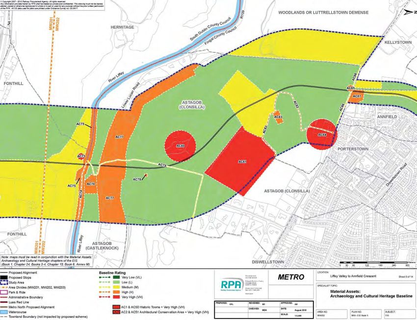
Page 3 of 49
                                                                                                     ENV-ACH-001.01
Archaeological Development Services Ltd.                                                               09 August 2011
Title: Archaeological Monitoring Report, Metro West and Metro North Dardistown Depot

7         MW/202/TP/014
8         MW/202/TP/015
9         MW/202/BH/010
10        MW/202/BH/011
11        MW/202/BH/012
12        MW/202/BH/014
13        MW/202/TP/021
14        MW/203/TP/003
15        MW/203/BH/001
16        MW/203/BH/005
17        MW/203/BH/009
18        MW/203/BH/014
19        MW/203/BH/015
20        MW/203/BH/016
21        MW/203/BH/012
22        MW/203/BH/017
23        MW/203/TP/016
24        MW/203/TP/027
25        MN/104/TP/001
26        IT1
27        IT1A
28        MN/104/BH/001
29        MN/104/TP/002
30        MN/104/TP/003
31        IT2
32        MN/104/BH/002
33        MN/104/TP/004
34        IT3
35        MN/104/BH/004
36        MN/104/BH/002A
37        MN/104/TP/009
38        MN/104/TP/010
39        MN/104/TP/005
40        IT4
41        MN/104/TP/006

                File Name: Archaeological Monitoring Report, Metro West and Metro North Dardistown Depot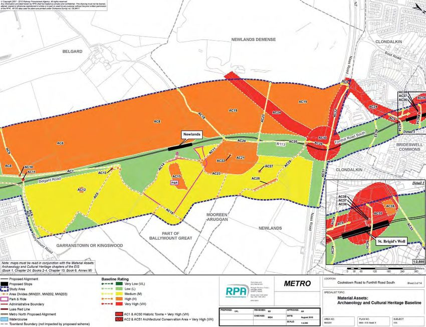
Page 4 of 49
                                                                                                    ENV-ACH-001.01
Archaeological Development Services Ltd.                                                              09 August 2011
Title: Archaeological Monitoring Report, Metro West and Metro North Dardistown Depot

42        MN/104/TP/007
43        MN/104/TP/008
44        MN/104/BH/003

               File Name: Archaeological Monitoring Report, Metro West and Metro North Dardistown Depot
Page 5 of 49
ENV-ACH-001.01
Archaeological Development Services Ltd. 09 August 2011
Title: Archaeological Monitoring Report, Metro West and Metro North Dardistown Depot
ABSTRACT
Archaeological monitoring of preliminary ground investigations was undertaken along
the route of the proposed Metro West scheme and at the site of the proposed Metro
North Dardistown Depot.
Metro West is a twin track light rail system which will serve approximately a 25km
corridor from the junction of Belgard Road/Old Blessington Road in Tallaght to
Dardistown. It will link Tallaght, Clondalkin, Liffey Valley and Blanchardstown and will
provide a fast commuter service to the city centre, Swords and the airport via Metro
North
Metro North is a 16.5km combined underground and surface light rail service
development linking Dublin City centre with Estuary (north of Swords) via Dublin
Airport. The proposed new Metro North Dardistown Depot is located adjacent to the
Metro North alignment in Dardistown townland.
Geotechnical investigations were required in order to provide factual data for use in
the design and construction of Metro West and the Metro North Dardistown Depot. It
was proposed to undertake Cable Percussion and Rotary Cored Boreholes, together
with trial pits to determine the nature and thickness of the underlying soils, and also
to ascertain the level and nature of the underlying rock as well as infiltration rates.
Archaeological monitoring of boreholes and trial pits was carried out in those areas
deemed to be within or adjacent to the zones of archaeological potential for a number
of RMP (Recorded Monuments and Places) sites including DU017:005 (ringfort –
unclassified); DU014:027 (Castle-Towerhouse), DU014:021 (Field system, possible)
and DU013:019 (church and graveyard; National Monument). In addition, a number
of boreholes/trial pits were within or adjacent to a number of areas of archaeological
potential as identified by the Metro West Environmental Impact Statement (EIS) and
the Metro North Dardistown Depot EIS.
The works undertaken for Metro West comprised the archaeological monitoring of 12
trial pits and 13 boreholes which were geographically dispersed along the route of
the proposed scheme within the townlands of Astagob (Castleknock By., Castleknock
ED), Cappagh, Cappoge, Clonburris Great, Coolmine (Castleknock By.), Corduff
(Castleknock By.), Dardistown, Irishtown (Castleknock By.), Merryfalls, Ronanstown,
Silloge, Snugborough (Castleknock By.).
Ten trial pits, 5 boreholes and 5 infiltration test pits were monitored at the site of the
Metro North Dardistown Depot.
File Name: Archaeological Monitoring Report, Metro West and Metro North Dardistown DepotPage 6 of 49
ENV-ACH-001.01
Archaeological Development Services Ltd. 09 August 2011
Title: Archaeological Monitoring Report, Metro West and Metro North Dardistown Depot
Nothing of apparent archaeological significance was located in any of the pits or
boreholes.
File Name: Archaeological Monitoring Report, Metro West and Metro North Dardistown DepotPage 1 of 49
ENV_ACH_
Archaeological Development Services Ltd. 09 August 2011
Title: Archaeological Monitoring Report, Metro West and Metro North Dardistown Depot
1.0 INTRODUCTION
Metro West is the next phase of Dublin’s integrated light rail network provided for by
Transport 21. Transport 21 was announced by the Minister for Transport in
November 2005 and, as incorporated into the National Development Plan 2007–
2013, represents Government policy on integrated transport commitments for the
country and in particular for the Greater Dublin Area. In addition to expenditure on
national roads, mainline and suburban rail, Transport 2021 provides for the delivery
of seven proposed new Luas Lines and two new Metro lines for Dublin. The
proposed scheme, Metro West, is one of these new proposals.
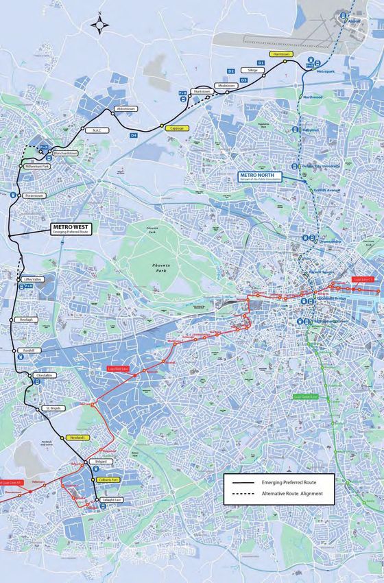
Metro West is a twin track light rail system which will serve approximately a 25km
corridor from the junction of Belgard Road/Old Blessington Road in Tallaght to
Dardistown. It will link Tallaght, Clondalkin, Liffey Valley and Blanchardstown and will
provide a fast commuter service to the city centre, Swords and the airport via Metro
North (RPA 2010). A Railway Order Application for Metro West was lodged with An
Bord Pleanála in October 2010.
Metro North will be a 16.5km combined underground and surface light rail service
development linking Dublin City centre with Estuary (north of Swords) via Dublin
Airport. An Bord Pleanála approved the Metro North Railway Order on 28th October
2010 with a number of modifications and conditions. In particular a Railway Order
was not granted for the depot, stop and strategic Park & Ride facility at Belinstown.
For the purposes of design and construction the Metro North route was broken into 7
number zones or section areas (MN101-MN107). The proposed new Metro North
depot (Dardistown Depot) is located adjacent to the Metro North alignment within
area MN104 (Dublin Airport Boundary (South) to M50 motorway), to the immediate
north of the Dardistown Stop. A Railway Order Application for the Metro North
Dardistown Depot was lodged with An Bord Pleanála in April 2011.
This report concerns the archaeological monitoring of preliminary ground
investigations. These were required in order to provide factual data for use in the
design and construction of the proposed Metro West and Metro North Dardistown
Depot schemes. Cable Percussion and Rotary Cored Boreholes, together with trial
pits were excavated to determine the nature and thickness of the underlying soils,
File Name: Archaeological Monitoring Report, Metro West and Metro North Dardistown Depot
1Page 2 of 49
ENV-ACH-001.01
Archaeological Development Services Ltd. 09 August 2011
Title: Archaeological Monitoring Report, Metro West and Metro North Dardistown Depot
and also to ascertain the level and nature of the underlying rock as well as infiltration
rates.
Geotech Specialists Ltd (part of Environmental Scientifics Group) carried out these
borehole and trial pit investigations along the proposed route of Metro West (from
Tallaght to Dardistown) and at the site of the proposed Metro North Dardistown
Depot. Archaeological monitoring was provided by Archaeological Development
Services Ltd (ADS Ltd) at the locations previously identified by the Railway
Procurement Agency (RPA) as being of archaeological sensitivity. The locations of
these works were geographically dispersed along the proposed scheme routes (Figs
19-24).
2.0 PROJECT BACKGROUND
2.1 METRO WEST
The EIS process identified 145 archaeological and cultural heritage constraints (AC1-
AC145) within a 250m study area of Metro West (information accessible at
http://www.dublinmetrowest.ie/Downloads/EIS/MW_EIS_Book_1/Metro_West_EIS_B
ook_1_Part_5_(Chapters_22-27).pdf) . These sites were identified through historical
and cartographic analysis and through a detailed field survey. In addition several
stages of invasive and non-invasive archaeological investigation were carried out on
the route of Metro West as part of the Environmental Impact Assessment process.
These investigations were carried out both prior to and contemporary with, the
current phase of archaeological monitoring:
− A geophysical survey of St. Brigid’s Well (DU021:010) and its environs
(Licence Ref. 08R0144;
http://www.rpa.ie/Documents/Archaeology/Metro%20West/01._Geophysical_Surv
ey_Report_St._Brigids_Well.pdf)
− Archaeological testing at a potential site ‘The Mad House’ in
Merryfalls townland (Area MW203; AC125, Licence Ref. 09E0274)
http://www.rpa.ie/Documents/Archaeology/Metro%20West/02._Archaeological_T
esting_Report_Merryfalls.pdf
− A non-invasive geophysical survey of the Metro West Emerging
Preferred Route (Licence Ref. 09R195;
http://www.rpa.ie/Documents/Archaeology/Metro%20West/03._Geophysical_
Survey_Report_Tallaght_to_Dardistown.pdf)
File Name: Archaeological Monitoring Report, Metro West and Metro North Dardistown DepotPage 3 of 49
ENV-ACH-001.01
Archaeological Development Services Ltd. 09 August 2011
Title: Archaeological Monitoring Report, Metro West and Metro North Dardistown Depot
- Advance targeted archaeological testing of 3 sites of archaeological
potential (Kildonan 110E0462; Merryfalls 1, 10E452 and Silloge 1, 10E460)
identified through the geophysical survey.
http://www.rpa.ie/Documents/Archaeology/Metro%20West/June_2011/Metro
_West_Archaeological_Test_Trenching_Kildonan_Co.Dublin.pdf
http://www.rpa.ie/Documents/Archaeology/Metro%20West/June_2011/Metro_
West_Archaeological_Test_Trenching_Merryfalls_Co.Dublin.pdf
http://www.rpa.ie/Documents/Archaeology/Metro%20West/June_2011/Metro_
West_Archaeological_Test_Trenching_Silloge_Co.Dublin.pdf
For ease of reference the Metro West preferred route corridor has been divided into
three areas as follows:
Area MW201: Old Blessington Road to Liffey Valley
Area MW202: Liffey Valley to National Aquatic Centre (NAC)
Area MW203 NAC to Dardistown
2.2 METRO NORTH DARDISTOWN DEPOT
The EIS process identified 25 archaeological, architectural and cultural heritage
constraints (AH1-AH25) within a 250m study area of the proposed Metro North
Dardistown Depot (information accessible at:
www.dublinmetronorthdepot.ie/Downloads/EIS/Main%20EIS/Chapters_22_to_26_inc
luding_Glossary_Final.pdf) . These sites were identified through historical and
cartographic analysis, a field survey, a geophysical survey (Licence Ref. 11R0017)
and advance archaeological testing (Licence Ref. 11E039). The archaeological
investigations were carried out both prior to and contemporary with, the current
phase of archaeological monitoring.
3.0 ARCHAEOLOGICAL, HISTORICAL AND CULTURAL HERITAGE
BACKGROUND
The proposed scheme is located in a rich and diverse archaeological and historical
environment with evidence of human ritual and settlement occupation from the
Neolithic to the present day. A summary of the Archaeological, Historical and Cultural
Heritage Background is provided here, a full version can be accessed at:
File Name: Archaeological Monitoring Report, Metro West and Metro North Dardistown DepotPage 4 of 49
ENV-ACH-001.01
Archaeological Development Services Ltd. 09 August 2011
Title: Archaeological Monitoring Report, Metro West and Metro North Dardistown Depot
http://www.dublinmetrowest.ie/Downloads/EIS/MW_EIS_Book_1/Metro_West_EIS_B
ook_1_Part_5_(Chapters_22-27).pdf.
3.1 PREHISTORIC PERIOD C.7000BC–AD400
Mesolithic period (c.7000BC–4000BC)
There is currently no evidence for Mesolithic occupation within the study area.
However, the proposed scheme passes through areas that may have attracted
settlement during this period. The Cammock (AC44; Area MW201), Liffey (AC75;
Area MW202), Tolka (AC97; Area MW202) and Santry (AC132; Area MW203) river
valleys and floodplains may have been exploited by Mesolithic communities and
evidence for such sites may be preserved in direct proximity to these waterways and
their associated tributaries.
Neolithic period (c.4000BC–2400BC)
The current evidence for Neolithic settlement within the study area is tentative and
restricted to a small number of stray finds recorded in the Topographic Files of the
National Museum of Ireland (NMI: as described in Annex M, Book 6, of this EIS).
Bronze Age (c.2400BC–500BC)
Archaeological remains from the Bronze Age are well represented within the study
area, though predominantly concentrating towards the southern end of the proposed
scheme within Area MW201 and Area MW202.
Iron Age (c.500BC–AD400)
There is no direct evidence of Iron Age activity within the study area. A possible
minor Iron Age enclosure is located c.750m to the east of the study area in the
townland of Ballymount Great (RMP DU015:021; Ó Néill 2001, 17).
File Name: Archaeological Monitoring Report, Metro West and Metro North Dardistown DepotPage 5 of 49
ENV-ACH-001.01
Archaeological Development Services Ltd. 09 August 2011
Title: Archaeological Monitoring Report, Metro West and Metro North Dardistown Depot
3.2 EARLY MEDIEVAL PERIOD (C.AD400–AD1100)
There is extensive evidence for early medieval settlement within the study area both
from early literary sources and surviving archaeological remains. Secular settlement
Ringforts are one of the most numerous and widely distributed monuments in the
Irish landscape. Three possible ringforts are located within the study area, of which
only one at Astagob within Castleknock Golf Club (AC80; Area MW202) has above
ground features. The other sites are located in the townlands of Porterstown (AC84;
Area MW202) and Cappoge (AC113; Area MW203). Settlement evidence for the
clerical population is equally well represented through a number of small and large
scale ecclesiastical sites located within the study area.
Ecclesiastical settlement
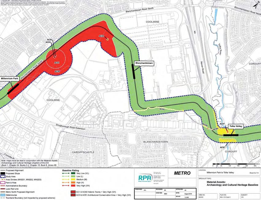
The remains of the early monastic settlement of Coolmine (National Monument
AC91–AC93; Area MW202), dating to the late 5th/early 6th century, is located within
the study area at Millennium Park. This ecclesiastical settlement, which according to
folklore was established by St. Mochta, a disciple of St. Patrick, is quite small with
known remains comprising a church and graveyard. Larger ecclesiastical sites within
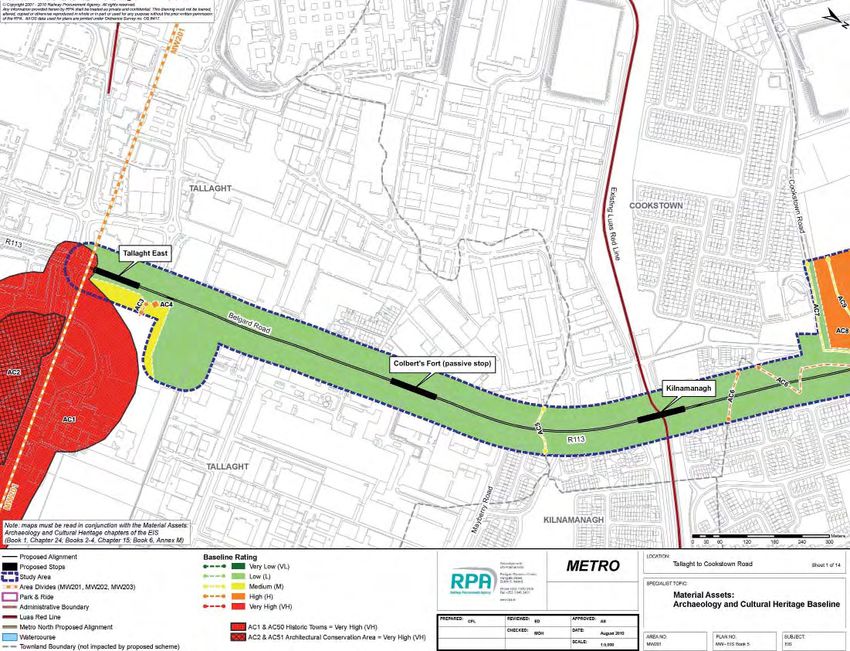
the study area are located at Tallaght (AC1; Area MW201) and Clondalkin (AC50;
Area MW201).
Viking settlement
Dublin City was an ecclesiastical centre seized by the Vikings in AD841 where they
developed a military base and trading centre (Duffy 2000, 48). Prior to the seizing of
Dublin the Vikings plundered Tallaght monastery (AC1; MW201) in AD811 and
Clondalkin monastery (AC50; MW201) in AD833 at which time the monastic
settlement was razed (Bradley et al. 1988, 215). By the mid 9th century Dublin Vikings
ruled lands north of the River Liffey (Area MW202 and Area MW203), a territory
known as Finne Gall. By 1052 the territory had retracted to the Devlin River, the
present-day boundary of Fingal (Downham 2005, 170). According to Joyce (1920,
275) the Tolka River (AC97; Area MW202) formed the southern boundary of ancient
Finne Gall.
File Name: Archaeological Monitoring Report, Metro West and Metro North Dardistown DepotPage 6 of 49
ENV-ACH-001.01
Archaeological Development Services Ltd. 09 August 2011
Title: Archaeological Monitoring Report, Metro West and Metro North Dardistown Depot
3.3 LATE MEDIEVAL PERIOD C.AD1100–AD1550
Anglo-Norman settlement
The monastic settlements at Tallaght (AC1; Area MW201) and Clondalkin (AC50;
Area MW201) represent the two urban centres within the study area at the time of the
Anglo-Norman conquest. Under the settlement the extensive lands belonging to both
churches were confirmed to the Anglo-Norman Archbishop of Dublin. An episcopal
borough was founded at each and by the 13th century the medieval towns of Tallaght
(AC1) and Clondalkin (AC50) emerged.
14 - 15 century
th th
During this time the Gaelic O’Byrne and O’Toole lords who controlled bordering
territories waged a guerrilla war against the Anglo-Norman settlers. This led to the
establishment of an Anglo-Norman defensive frontier boundary in 1435 known as the
“inglishe Pale” (O’Keeffe 1992). The study area lay within the southern boundary of
the Pale, which extended west from Dublin along the River Dodder to Oldbawn
(south of Tallaght), continuing west to Saggart and to County Kildare (Joyce 1920,
429 and 434). The Pale boundary functioned as the interface between native and
alien populations and had “no tangible boundaries in the cultural landscape before
1494” (O’Keeffe 1992). From this time onwards the boundary was formalised through
the sporadic erection of a defensive earthwork boundary creating a formal cultural
divide between the Anglo-Norman and Irish populations.
3.3 POST-MEDIEVAL PERIOD C.AD1550–AD1700
The physical landscape of Ireland changed considerably during this period and in the
17th century open fields were enclosed and consolidated into compact farms. This 17th
century change in the land division heavily influenced Ireland’s cultural heritage and
is reflected in the current pattern of field division within the study area.
File Name: Archaeological Monitoring Report, Metro West and Metro North Dardistown DepotPage 7 of 49
ENV-ACH-001.01
Archaeological Development Services Ltd. 09 August 2011
Title: Archaeological Monitoring Report, Metro West and Metro North Dardistown Depot
3.4 INDUSTRIAL AGE C.AD1700–AD1900
The dawn of the 18th century heralded a new era for Dublin and its hinterland.
Agriculture and textile industries became the backbone of the Irish economy as trade
links with European ports gradually expanded. The development of inland
navigational systems such as the Grand (Area MW201) and Royal (Area MW202)
Canals, began in 1756 and 1790 respectively and further supported Ireland’s
economic development (as described in the Material Assets: Architectural Heritage
baseline chapter of the EIS (Book 1, Chapter 25).
3.5 RMP SITES
The majority of the boreholes/trial pits located in urban contexts were in green
verge/parklands. A number of the boreholes/trial pits were located in proximity to four
RMP sites, either within the constraint zones or the environs of the constraint zones
details of which are outlined below. No works were proposed for within 50m of the
National Monument at Coolmine (DU013:019). As well as RMP sites, a number of the
boreholes/trial pits were located within other areas of archaeological potential as
identified in the EIS and as set out in Table 3.5.1
Table 3.5.1 Metro West Exploratory holes in relation to Sites of Archaeological
potential
Exploratory hole Townland Archaeolog AC/RMP description
requiring ical
archaeological Constraint
monitoring
MW201/BH/010 Clonburrris Near AC55 Townland Boundary
(Fig. 19) Great Site of townland boundary. The extent of
the original townland boundary is not
recorded and is presently defined by the
Grand Canal, construction of which
commenced in 1756.
MW201/BH/011 Cappagh, AC55 As above
(Fig. 19)
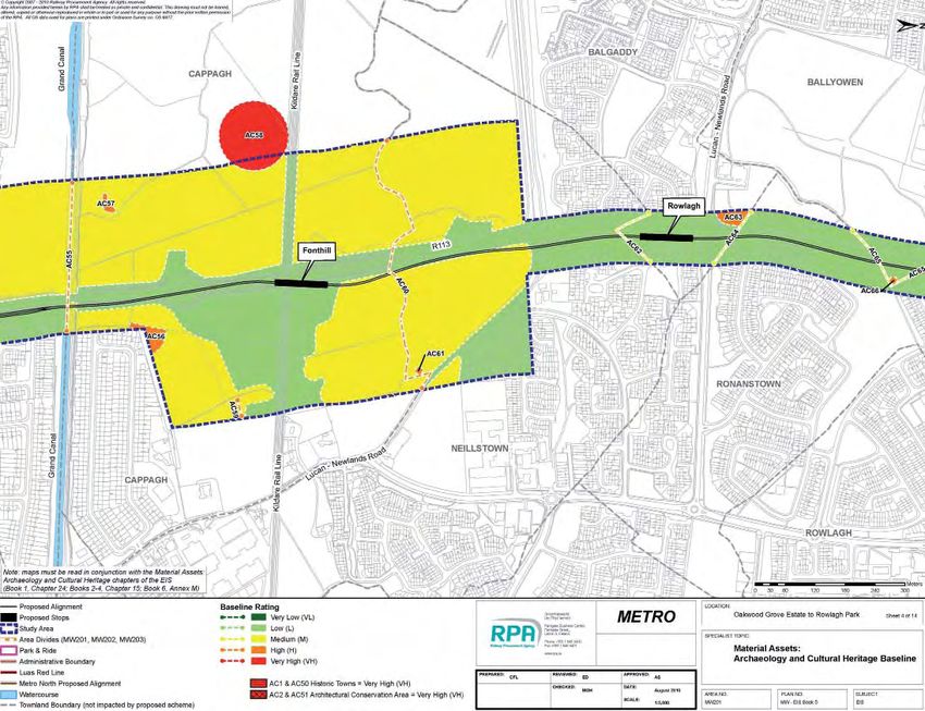
MW201/TP/016 Ronanstown Near AC65 Townland Boundary
(Fig. 19) Site of townland boundary. No extant
remains survive within the study area.
The site of the townland boundary is now
marked by pathways within Ballyowen
Park and within the green areas of
Rowlagh Park.
File Name: Archaeological Monitoring Report, Metro West and Metro North Dardistown DepotPage 8 of 49
ENV-ACH-001.01
Archaeological Development Services Ltd. 09 August 2011
Title: Archaeological Monitoring Report, Metro West and Metro North Dardistown Depot
MW201/TP/018 Irishtown Near AC67 Townland Boundary
(Fig. 19) Site of townland boundary, now primarily
occupied by housing developments. No
extant remains survive; subsurface
remains may be present within green
areas of Rowlagh Park.
MW202/TP/011 Coolmine AC90 DU- AC90: Demesne Land
(Fig. 20) 50 O- Lands of Coolmine House marked on 1st
066386 Edition OS Map of 1843. Extant remains
surviving within present day Millennium
Park include the walled gardens,
laneways and associated field system.
MW202/TP/012 Coolmine AC90 DU- AC90 As above
(Fig. 20) 50-O- AC91: Archaeological Complex
066386 Zone of Archaeological Potential for
AC91/ National Monument AC92–AC93,
AC92/AC9 comprising a church
3 and graveyard.
DU013:019 AC92 (DU013:019): Church
Site of the “White Chapel of St. Mochtas”.
National Monument. The “Church of
Culmyn” was established in the 5th
century by St.Mochta, a disciple of St.
Patrick. It was recorded in several 13th
century documents but is reference as
“moribund about 1419” and disappeared
from written sources after its sale to St.
Mary’s Abbey in 1485–1486 (SMR File;
Ball 1906, 6). No extant structural remains
pertaining to the church were present in
1974 (Healy 1974–1975). The site is not
marked on Rocque’s map of 1760 but is
st
marked on the 1 Edition OS Map of
1843. The site was partially truncated and
heavily landscaped during the
development of Millennium Park.
AC93: Graveyard
Site of graveyard associated with
Coolmine Church. National Monument.
“Locally known to be an old graveyard of
St. Mochua”. Field examinations in 1974
record a graveyard “in which is a cross
dated 1880. There are many human
bones exposed” (Healy 1974–1975).
The graveyard survives as a sub-oval
earthen mound (c.50m east-west by 30m
by 0.60m in height) with a number of
mature sycamore trees. The site was
partially truncated and heavily landscaped
during the development of Millennium
Park.
File Name: Archaeological Monitoring Report, Metro West and Metro North Dardistown DepotPage 9 of 49
ENV-ACH-001.01
Archaeological Development Services Ltd. 09 August 2011
Title: Archaeological Monitoring Report, Metro West and Metro North Dardistown Depot
MW202/TP/013 Coolmine AC90 DU- As above
(Fig. 20) 50-O-
066386
AC91
/AC92/AC9
3
DU013:019
MW202/TP/014 Coolmine AC90 DU- As above
(Fig. 20) 50-O-
066386
MW202/TP/015 Coolmine AC90 DU- AC90 As above
(Fig. 20) 50-O- AC94: Site of Archaeological Potential
066386 Crop mark identified on Aerial Photograph
and near Number 3129-19-RPA. Subcircular in plan
AC94 it may represent the remains of a
subsurface enclosure with a diameter of
c.24m.
MW202/BH/010 Coolmine Near AC95: Townland Boundary
(Fig. 21) AC95/AC9 Site of townland boundary now primarily
6 occupied by commercial and residential
developments. Extant portions may
survive as tree lined field boundary to
southwest of study area.
AC96: Townland Boundary/River
Site of townland boundary defined by the
old course of the Tolka River (AC97).
Subsurface remains may survive within
Tolka Valley Park.
MW202/BH/011 Coolmine Near As above
(Fig. 21) AC95/AC9
6
MW202/BH/012 Corduff Near AC97 River
(Fig. 21) Tolka River: Rivers and their associated
floodplains are deemed to be areas of
archaeological potential and may have
been exploited for various purposes.
MW202/BH/013 Corduff Near AC97 As above
MW202/BH/014 Corduff Near AC97 As above
(Fig. 21)
File Name: Archaeological Monitoring Report, Metro West and Metro North Dardistown DepotPage 10 of 49
ENV-ACH-001.01
Archaeological Development Services Ltd. 09 August 2011
Title: Archaeological Monitoring Report, Metro West and Metro North Dardistown Depot
MW202/TP/021 Corduff AC99 and AC99: River
(Fig. 21) near Tolka River Tributary: Partially follows
AC100 course of AC98, AC101 and AC102.
Rivers and their associated floodplains
are deemed to be areas of archaeological
potential and may have been exploited for
various purposes.
AC100: Site of Archaeological Potential
Area of archaeological potential as
identified through analysis of 1st Edition
OS Map of 1843. A distinct curvature in
the Deanestown/Corduff townland
boundary may demarcate the remains
of a possible subsurface enclosure c.40m
in diameter.
MW203/TP/003 Snugborough AC103 and AC103: Site of Archaeological Potential
(Fig. 21) near AC99 Analysis of the 1st Edition OS Map of
1843 indicates that the townland of
Snugborough may comprise the remains
of Anglo-Norman burgage plots laid out in
a linear pattern on a northeast-southwest
orientation. Subsurface remains may
survive within greenfield areas of
Abbotstown (1st Edition OS Map of 1843).
MW203/BH/001 Cappoge AC109 Castle-Towerhouse
(Fig. 22) DU014:027 Zone of archaeological potential for
Cappoge Castle. Site of 16th century
towerhouse, with bawn wall and gate
tower. Once the home of the Keppock
and subsequently the Woodlock and
Dillon families (Ball 1920, 17–18). All
structures marked on Rocque’s map of
1760. In 1780 the castle was recorded by
Austin Cooper in ruins with walls that
stood 30ft high and were 3ft thick; the
arched gate tower was extant at this time
(Ball 1920, 25–26). Marked as “site of” on
the 1st Edition OS Map of 1843. The
castle was demolished before 1860 (SMR
File). Aerial Photography within the SMR
File marks a possible sunken road in
association with the castle. The area has
recently been archaeologically
investigated; the castle foundations were
not identified (Myles 2000; McQuade pers
comm.).
MW203/BH/005 Cappoge AC112 Settlement, Site of
(Fig. 22) Site of settlement and access lane
marked on Rocque’s map of 1760 as
comprising four structures, gardens and
laneway. Marked on the 1st Edition OS
Map of 1843 as “Cappoge”. The site has
recently been heavily disturbed but some
subsurface traces of this 18th century
settlement may survive in greenfield
areas adjacent to the M50.
File Name: Archaeological Monitoring Report, Metro West and Metro North Dardistown DepotPage 11 of 49
ENV-ACH-001.01
Archaeological Development Services Ltd. 09 August 2011
Title: Archaeological Monitoring Report, Metro West and Metro North Dardistown Depot
MW203/BH/009 Merryfalls AC121 & AC121: River
(Fig. 23) AC129 Santry River Tributary: Rivers and their
DU014:021 associated floodplains are deemed to be
areas of archaeological potential and may
have been exploited for various purposes.
AC129 (DU014:021): Field System,
possible
Possible medieval field system identified
from aerial photographs taken by the
Fairey Survey of Ireland 1971 (2.411/10;
SMR File). The system is contained within
a complex of three fields. It is clearly
visible in aerial photography where the
site presents as a complex of subsurface
rectangular fields (Aerial Photograph
Number 3063-18-RPA). The subsurface
remains of a laneway marked on Taylor’s
map of 1816 is also visible in aerial
photography. The extant remains of a
farm compound also marked on Taylor’s
map of 1816, and subsequently on the 1st
nd
and 2 Edition OS Maps of 1843 and
1871–1875 are located adjacent to the
eastern boundary of the field system.
MW203/BH/012 Silloge n/a
(Fig. 23)
MW203/BH/014 Merryfalls Near AC121 & AC129 as above
(Fig. 23) AC122 & AC122: Site of Archaeological Potential
AC125 Crop mark identified on Drawing No.
AC121 & 3.4.2.1 (Eptisa 2009). Pattern of
AC129 intersecting linear lines, potentially
DU014:021 representing a late/ post medieval field
system measuring approximately 320m
north-south by 320m east-west.
AC125: House, site of
Single house structure and associated
access lane marked on Taylor’s map of
1816 as “the Mad House”. Recorded but
not named on the 1st and 2nd Edition OS
Maps of 1843 and 1871–1875
respectively (Turgel 2007, 14). Recent
archaeological investigations identified
the house as being a simple two room
structure with limestone and red brick
walls and a slate roof (Hackett 2009). It
may originally have functioned as a home
to care for an individual with a mental
illness.
MW203/BH/015 Merryfalls Near As above
(Fig. 23) AC122
&AC125
AC121 &
AC129
DU014:021
File Name: Archaeological Monitoring Report, Metro West and Metro North Dardistown DepotPage 12 of 49
ENV-ACH-001.01
Archaeological Development Services Ltd. 09 August 2011
Title: Archaeological Monitoring Report, Metro West and Metro North Dardistown Depot
MW203/BH/016 Merryfalls AC121 & As above
(Fig. 23) AC129
DU014:021
MW203/BH/017 Silloge AC128 and AC128: Site of Archaeological Potential
(Fig. 23) AC129 Identified through a geophysical survey
DU014:021 and cartographic analysis as comprising a
“circular enclosure measuring c.30m in
diameter” and a “sub-rectangular ditched
enclosure with associated pit-type
anomalies” (CRDS 2003, 121; Nicholls
2010, 17 & 18). The circular enclosure
was interpreted as the possible remains
of an early medieval ringfort. The sub-
rectangular enclosure (measuring c.25m
by 50m, was interpreted as the remains of
a potential prehistoric settlement.
MW203/TP/016 Silloge AC121 & As above
(Fig. 23) AC129
DU014:021
MW203/TP/027 Silloge AC121 & As above
(Fig. 23) AC129
DU014:021
4.0 DESCRIPTION OF THE BASELINE ENVIRONMENT
This section provides a summary description of the archaeological and cultural
heritage baseline environment for the proposed scheme. The full description can be
accessed at
http://www.dublinmetrowest.ie/Downloads/EIS/MW_EIS_Book_1/Metro_West_EIS_B
ook_1_Part_5_(Chapters_22-27).pdf. The description of the baseline environment
should be read in conjunction with the baseline maps (Figs 3-18). The latter details
the historical and cultural heritage background and recorded archaeological finds for
the townlands within the study area.
For further information on townlands and topographic files refer to: RPA, EIS Annex
M 1 Material Assets: Archaeology and Cultural Heritage by Emer Dennehy, 2010.
4.1 AREA MW201: OLD BLESSINGTON ROAD TO LIFFEY VALLEY
The proposed scheme in Area MW201 passes through the townlands of Tallaght,
Cookstown, Garranstown or Kingswood, Belgard, Mooreenaruggan, Part of
File Name: Archaeological Monitoring Report, Metro West and Metro North Dardistown DepotPage 13 of 49
ENV-ACH-001.01
Archaeological Development Services Ltd. 09 August 2011
Title: Archaeological Monitoring Report, Metro West and Metro North Dardistown Depot
Ballymount Great, Newlands, Newlands Demesne, Clondalkin, Brideswell Commons,
Commons, Fairview, Clonburris Great, Cappagh, Neillstown, Balgaddy, Ronanstown,
Ballyowen, Irishtown, Yellow Walls and Fonthill (as included in Annex M, Book 6, of
the EIS). A total of 72 archaeological and cultural heritage sites were identified for
Area MW201.
The proposed scheme starts in the townland of Tallaght at the northwestern extent of
the historic town. From Tallaght, the proposed scheme runs through the townland of
Cookstown along Belgard Road. The lands in Cookstown have primarily been
developed for residential and industrial purposes.
From Cookstown, the proposed scheme continues north through the townlands of
Garranstown/ Kingswood, Belgard, Mooreenaruggan, Part of Ballymount Great,
Newlands and Newlands Demesne. These lands are primarily greenfield and amenity
lands; From Newlands, the study area crosses the N7 and progresses along the
Fonthill Road through part of the townlands of Clondalkin and Brideswell Commons.
From Brideswell Commons, the study area continues through the townlands of
Clondalkin, Commons and Fairview. These lands have primarily been developed for
residential purposes though some parkland is present. From Clondalkin, the study
area crosses the Old Nangor Road and proceeds through developed land in the
townland of Clonburris Great before reaching the Grand Canal. On crossing the
Grand Canal, the study area continues northwards parallel to Fonthill Road through
the townlands of Cappagh and Neillstown.
From Neillstown, the study area continues north through the townlands of Balgaddy,
Ronanstown, Ballyowen, Irishtown, Yellow Walls and Fonthill. These lands are
primarily developed for retail and residential use but parklands are present within
Ballyowen townland.
4.2 AREA MW202: LIFFEY VALLEY TO NATIONAL AQUATIC CENTRE (NAC)
The proposed scheme in Area MW202 passes through the townlands of Fonthill,
Hermitage, Astagob (Parish of Clonsilla), Astagob (Parish of Castleknock),
Woodlands or Luttrellstown Demesne, Kellystown, Porterstown, Annfield, Coolmine,
Blanchardstown, Corduff and Deanestown (as included in Annex M, Book 6, of the
EIS). A total of 28 archaeological and cultural heritage sites were identified for Area
MW202.
File Name: Archaeological Monitoring Report, Metro West and Metro North Dardistown DepotPage 14 of 49
ENV-ACH-001.01
Archaeological Development Services Ltd. 09 August 2011
Title: Archaeological Monitoring Report, Metro West and Metro North Dardistown Depot
From the townland of Fonthill, the study area crosses the Liffey Valley before
entering Hermitage, Astagob (Parish of Castleknock and Clonsilla) and Woodlands or
Luttrellstown Demesne townlands. These lands are primarily amenity lands.
The study area for the proposed scheme extends northwards to the Royal Canal and
continues north parallel to Blanchardstown Road South. From Blanchardstown Road
South it turns eastwards to the Tolka Valley (AC97) passing through the townlands of
Annfield, Kellystown, Porterstown, Coolmine and Blanchardstown. These lands have
been intensively developed for commercial and residential purposes with areas of
parklands present at Coolmine (Millennium Park).
From Tolka Valley the study area continues in a northeast direction parallel to the
Snugborough Road to the NAC through the townlands of Corduff and Deanestown.
These lands have been intensively developed for residential purposes, though some
greenfield land is present in Deanestown.
4.3 AREA MW203: NAC TO DARDISTOWN
The proposed scheme in Area MW203 continues through the townlands of
Deanestown, and on through Snugborough, Ballycoolen, Sheephill, Cappoge,
Dunsink, Kildonan, Cardiffs Castle, Huntstown, Balseskin, Coldwinters, Dubber,
Charlestown, Meakstown, Merryfalls, Poppintree, Silloge, Harristown, Ballymun,
Coultry and Ballystruan (as included in Annex M, Book 6, of the EIS). A total of 50
archaeological and cultural heritage sites were identified for Area MW203.
Between the NAC and the M50 motorway (M50), the study area passes through the
townlands of Deanestown, Snugborough, Ballycoolen, Sheephill and Cappoge.
These lands to the south of Ballycoolin Road are primarily greenfield; those to the
north have been developed for industrial and residential purposes.
On reaching the M50, the proposed scheme runs parallel to the M50 in a northeast
direction, before veering northwards at Meakstown. The study area passes through
the townlands of Dunsink, Kildonan, Cardiffs Castle, Huntstown, Balseskin,
Coldwinters, Dubber, Charlestown and Meakstown. These lands are primarily
greenfield to the north of the M50.
From Meakstown to Harristown, the study area comprises greenfield lands in the
townlands of Meakstown, Merryfalls, Poppintree, Silloge and Harristown.
File Name: Archaeological Monitoring Report, Metro West and Metro North Dardistown DepotPage 15 of 49
ENV-ACH-001.01
Archaeological Development Services Ltd. 09 August 2011
Title: Archaeological Monitoring Report, Metro West and Metro North Dardistown Depot
Between Silloge and Dardistown, the study area for the proposed scheme comprises
primarily Greenfield lands in the townlands of Ballymun, Coultry and Ballystruan.
4.4 METRO NORTH DARDISTOWN DEPOT BASELINE ENVIRONMENT
The study area for Metro North Dardistown Depot included parts of townlands
Ballymun, Coultry, Ballystruan and Collinstown. The land was predominantly used for
arable farming and there were very few sizeable structures located within the study
area.
A number of amenity and leisure facilities are located within the study area including
four sports grounds, two in Ballystruan and one each in Ballymun and Coultry
(HC21–HC24), a small section of a golf course within the westernmost section and a
small section of Dublin Airport’s runway area is located northeast of Silloge Park.
Five townland boundaries (HC13–HC18) and an historic laneway (HC19) fall within
the study area.
4.5 METRO NORTH DARDISTOWN DEPOT CONSTRAINTS
In addition to the constraint areas identified in the Metro West EIS for the Dardistown
Depot there were also constraints identified in a subsequent EIS submitted for Metro
North Dardistown Depot which cover the townlands of Ballymun and Ballystruan
(RPA 2011). These are illustrated in Figures 17 and 18.
File Name: Archaeological Monitoring Report, Metro West and Metro North Dardistown DepotPage 16 of 49
ENV_ACH_
Archaeological Development Services Ltd. 09 August 2011
Title: Archaeological Monitoring Report, Metro West and Metro North Dardistown Depot
Table 4.5.1 Metro North Dardistown Depot Exploratory holes in relations to sites of
archaeological potential
Exploratory hole Townland Archaeological AC Description HC Description
requiring Constraint
archaeological Metro West
monitoring (AC) & Metro
North (HC)
MN/104/BH/001 Ballymun Near Area HC10: Flattened
AC145: Site of
MW203 AC145 remains of burnt
Archaeological
& HC10 mound (Ballymun
Potential
3). The site
Identified in the Metro consists of
North Geophysical archaeological
Survey as an area of remains comprising
archaeological a curvilinear
potential. Subsurface spread/feature of
remains comprise a heat fractured
linear boundary stone and charcoal
recorded on the 1st rich clay. This type
Edition OS Map of of site
1843. A number of predominately
linear trends recorded dates to the Bronze
may represent Age (c. 2400-
subsurface 500BC). It was
archaeological identified as
remains (Thebaudeau Ballymun 3 during
& Harrison 2009, 32). archaeological
testing carried out
as part of advance
investigative works
for the Metro North
Dardistown Depot.
MN/104/BH/002 Ballymun AC145 & next
AC146:townland
note to AC146 &
Boundary Site of HC19: Laneway
moved HC19
townland boundary. Unnamed laneway
from
Follows central course marked on
original
of laneway leading Rocque’s map
location in
from Ballystruan (1760) with the
Ballystruan
House to Harristown southern section
Lane (AC140). Extant orientated in an
remains within the approximate
study area survive as north/south
parallel earthen banks direction and the
with mature tree northern
coverage and central section orientated
laneway. A ditch in an approximate
containing a culverted west/east
stream runs parallel to direction.
each side of the Subsequently
depicted in more
File Name: Archaeological Monitoring Report, Metro West and Metro North Dardistown Depot
16Page 17 of 49
ENV-ACH-001.01
Archaeological Development Services Ltd. 09 August 2011
Title: Archaeological Monitoring Report, Metro West and Metro North Dardistown Depot
laneway detail, but
still unnamed on
historic OS maps
(1843; 1872;
1910). Its northern
most section is
shown to largely
follow townland
boundaries in the
area
(Ballystruan/Ballym
un – HC13;
Ballystruan/Coultry
– HC16;
Ballymun/Coultry –
HC17). The historic
OS
map dating to 1939
shows a similar
arrangement
excepting the
southern most
section which is no
longer extant on
this map. The
laneway is currently
occupied by
“Ballystruan Lane“
which is for the
most part a tree-
lined laneway and
has either a
rough tarmac
surface or hardcore
surface. The
southern most
section is currently
occupied by a
roadway leading off
the R108 in a
west/east
direction.
Approximately
1,970m of this
laneway
falls within the
study area.
MN/104/BH/002 Ballystruan Near AC145
a and AC146,
HC19 & HC21
MN/104/BH/003 Ballystruan AC149 & near HC21:Sports
AC149:
HC7 & HC21 grounds:
Archaeological
Whitehall Rangers
Complex
FC
Identified in the Metro Whitehall Rangers
North EIS through FC is located in
File Name: Archaeological Monitoring Report, Metro West and Metro North Dardistown DepotPage 18 of 49
ENV-ACH-001.01
Archaeological Development Services Ltd. 09 August 2011
Title: Archaeological Monitoring Report, Metro West and Metro North Dardistown Depot
aerial photography Ballystruan to
(Aerial Photograph the immediate east
3064-16) as a possible of Ballystruan Lane
late medieval moated off
site due to the Collinstown
identification of a Lane/SPR. Its
rectangular crop mark. home ground is
A geophysical survey known’s Paddy
of AC149 did not Mahony Park.
identify the remains of
a moated site. A
number of field
boundaries illustrated
on 19thcentury
cartographic sources
were noted by the
survey, in addition to
several pit-type and
linear responses
which may be
archaeological in
origin. Archaeological
testing for Metro North
identified an enclosure
site, a large pit
containing burnt
mound material and a
cremation pit (Metro
North EIS, Volume 1,
Book 1, Chapter 23,
424; Thebaudeau and
Harrisson 2009, 30–
31; Frazer 2010).
MN/104/BH/004 Ballymun AC145 & next HC9: Pits and
to AC146, HC9 linear features
& HC19 (Ballymun 2)
This site consists of
subsurface
archaeological
remains comprising
four pits and a
linear feature.
No dating evidence
was recovered from
the
identified features.
However, the
feature fills
indicate that the
site may have
originally consisted
of a burnt mound
and therefore
suggests a
provisional Bronze
Age date (c. 2400–
500BC) for
File Name: Archaeological Monitoring Report, Metro West and Metro North Dardistown DepotPage 19 of 49
ENV-ACH-001.01
Archaeological Development Services Ltd. 09 August 2011
Title: Archaeological Monitoring Report, Metro West and Metro North Dardistown Depot
this site. This site
was identified as
Ballymun 2
during
archaeological
testing carried out
as part of
advance
investigative works
for Metro North.
MN/104/TP/001 Ballymun Near AC145 &
HC10
MN/104/TP/002 Ballymun AC145 & near
HC19
MN/104/TP/003 Ballymun AC145
MN/104/TP/004 Ballymun AC145 & near
HC9 & HC19
MN/104/TP/005 Ballystruan Near AC148 & HC7:Site of
AC148: House, site of
, note within HC7 archaeological
moved House site recorded potential (Group
from on Rocque’s map of of
original 1760 and buildings and
location in subsequently recorded associated
Ballymun with surrounding laneway, site of)
gardens on 1st Edition This site was
OS Map of 1843. This identified in the
house has been Metro West EIS.47
demolished and a new It
one built in its stead. comprises the site
Subsurface remains of of a group of four
associated outhouse buildings with
may survive within the an associated
property grounds. laneway recorded
on Rocque’s “Map
of County Dublin”
dating to 1760 and
is
subsequently
recorded with an
adjacent garden on
historic OS map
dating to 1843. On
subsequent OS
maps published in
1872, 1910 and
1936, the
number and
configuration of
buildings has
changed.
The buildings are
no longer extant
and a sports
ground and modern
File Name: Archaeological Monitoring Report, Metro West and Metro North Dardistown DepotPage 20 of 49
ENV-ACH-001.01
Archaeological Development Services Ltd. 09 August 2011
Title: Archaeological Monitoring Report, Metro West and Metro North Dardistown Depot
attendant buildings
now occupy
the area. During a
field inspection, two
stone
gateposts were
noted that could
possibly belong to
a more recent
phase of the now
demolished group
of buildings. No
other above ground
remains were
noted during the
site visit. There is
potential for
subsurface remains
associated with this
former building
complex to be
extant in the area.
MN/104/TP/006 Ballystruan Near AC148 &
, note within HC7 &
location HC21
moved
slightly to
west from
original
location
MN/104/TP/007 Ballystruan Near AC148 &
within HC7 &
HC21
MN/104/TP/008 Ballystruan AC149 & near
HC7 & HC21
MN/104/TP/009 Ballystruan AC147 & near HC13: Townland
AC 147:site of
HC13 & HC19 Boundary
Archaeological
Townland boundary
Potential
between
Identified in the Metro Ballystruan and
North Geophysical Ballymun, of which
Survey as an area of a c. 595m long
archaeological section falls within
potential. Subsurface the study area. This
remains comprise a section is
curvilinear response approximately
possibly representing orientated in a
a ditched enclosure northwest/southeas
(Thebaudeau & t direction and is
Harrison 2009, 32). largely demarcated
Archaeological testing by a central
identified evidence of trackway (with
post-medieval hardcore surface).
agricultural activity Commencing at the
(Frazer & Hession, northern
File Name: Archaeological Monitoring Report, Metro West and Metro North Dardistown DepotPage 21 of 49
ENV-ACH-001.01
Archaeological Development Services Ltd. 09 August 2011
Title: Archaeological Monitoring Report, Metro West and Metro North Dardistown Depot
2010). end, the laneway is
bound by hedgerow
and trees
to the east for c.
220m, by a shallow
parallel ditch
for the next c. 140m
and by a concrete
post and
wire fence for the
next c. 145m.
There are no
upstanding
elements for the
remaining c. 90m,
however there is a
cropmark visible in
aerial
photographs along
the alignment of
this former
boundary,
indicating potential
extant subsurface
remains. The
western side of the
laneway is defined
by an interrrupted
bank and ditch,
which is filled by
a channelled
section of the
Mayne River
tributary
for c. 280m from
the northern end.
The remaining
length of the
western side of the
laneway is
undefined.
A 150m long
section of this
boundary was
surveyed
and a single test
trench was
excavated through
a
portion of the
townland boundary
as part of
advance
investigative works
for Metro North.20
This
trench was located
File Name: Archaeological Monitoring Report, Metro West and Metro North Dardistown DepotPage 22 of 49
ENV-ACH-001.01
Archaeological Development Services Ltd. 09 August 2011
Title: Archaeological Monitoring Report, Metro West and Metro North Dardistown Depot
c. 365m from the
northern end
and identified within
was a u-shaped
boundary ditch
located to the west
of the central
laneway which
appeared to have
been dug by
modern machinery
rather than being
an original feature
of the townland
boundary.
MN/104/TP/010 Ballystruan AC147 & near
HC13 & HC19
IT1 Ballymun Near AC145
&HC19
IT1a Ballymun Near AC145
&HC19
IT2 Ballymun AC145 & near
AC146 &
HC19
IT3 Ballymun AC145 & near
AC146 & HC9
IT4 Ballystruan AC147
5.0 MONITORING METHODOLOGY
Archaeological monitoring was carried out for the excavation of boreholes and trial
pits deemed to be within or adjacent to the zones of archaeological potential for a
number of RMP (Recorded Monuments and Places) sites including DU017:005
(ringfort – unclassified; DU014:027 (Castle-Towerhouse) DU014:021 (Field system,
possible) DU013:019 (church and graveyard; National Monument). In addition, a
number of boreholes/trial pits were within or adjacent to areas of archaeological
potential as identified by the Metro West Environmental Impact Statement (EIS)
(Table 3.5.1) and the Metro North Dardistown Depot EIS (Table 4.5.1) and these
areas and the relevant boreholes/pits are identified in Tables 6.0.1 & 6.1.1 below.
File Name: Archaeological Monitoring Report, Metro West and Metro North Dardistown DepotPage 23 of 49
ENV-ACH-001.01
Archaeological Development Services Ltd. 09 August 2011
Title: Archaeological Monitoring Report, Metro West and Metro North Dardistown Depot
The purpose of the advance monitoring was to determine the presence or absence of
archaeological features, structures, deposits, artefacts or ecofacts along the route of
the proposed scheme which may otherwise be affected by the works.
An archaeological licence 10E410 was issued on the 22nd September 2010 for the
monitoring of selected borehole and trial pit locations along the route.
All work was undertaken in accordance with the terms of the archaeological licence
and the terms of the Archaeological Code of Practice agreed between the Railway
Procurement Agency (RPA) and the Minister for the Environment, Heritage and Local
Government. All boreholes comprised the hand excavation of a 1.2m deep inspection
pit, prior to drilling. Each of these pits had an average diameter of 0.4m. Trial pits
were excavated by a JCB machine fitted with a 0.5m bucket. Trial pits were
excavated to an average width of 0.50m, to depths of approximately 3m and varied in
length from 2-3m.
Each borehole/trial pit was archaeologically monitored until such time as natural
subsoil or archaeological deposits were reached, whichever was encountered first.
Each borehole/trial pit was photographed at pre, mid and post-excavation stage and
the exposed stratigraphy was recorded.
6.0 MONITORING RESULTS
The excavation of a total of 12 trial pits and 13 boreholes were archaeologically
monitored along the route of Metro West, (Table 6.0.1). In addition a further 10 trial
pits, 5 boreholes and 5 infiltration test pits were monitored at the location of the
proposed Metro North Dardistown Depot (Table 6.1.1). Monitoring took place
intermittently form October 2010 to February 2011. Nothing of apparent
archaeological significance was located in any of the pits or boreholes.
In two of the borehole inspection pits and two of the trial pits subsoil was not
encountered and due to the depth of the trial pits and the restriction of the borehole
inspection pits it was not possible to definitively say that there were no archaeological
deposits present. The pits in question are: MW/202/BH/011, MN/104/BH/003,
MN/104/TP/005 and MN/104/TP/010. The lack of subsoil in the boreholes could
indicate the presence of an underlying deep archaeological feature such as a pit or
ditch; or may related to substantial deposits of made ground. As the trial pits were
File Name: Archaeological Monitoring Report, Metro West and Metro North Dardistown DepotYou can also read