Design Brief for Proposed Mixed-Use Medical / Office Building
←
→
Page content transcription
If your browser does not render page correctly, please read the page content below
Design Brief for Proposed Mixed-Use Medical / Office Building
1637 Bank Street, Ottawa ON

Project No:   PC2014-0263

Date:         June 25th, 2015

For:          Kersten Nitsche, Planner II
              Development Review (Urban Services)
              City of Ottawa
              110 Laurier Avenue West
              Ottawa ON K1P1J1
Table of Contents

    1.0   Section 1

          1.1    Introduction                                                    4
                 1.1.1 Project Description                                       4

          1.2    Official Plan                                                   4
                 1.2.1 Objective                                                 4
                 1.2.2 Building Liveable Communities Strategic Direction         5
                 1.2.3 Managing Growth Strategic Direction                       6
                 1.2.4 Maintaining Environmental Integrity Strategic Direction   6
                 1.2.5 Providing Infrastructure Strategic Direction              6

          1.3    Arterial Mainstreet Urban Designation                           6
                 1.3.1 Objective                                                 6
                 1.3.2 Mainstreet Principle                                      6

          1.4    Bank Street Secondary Plan & Community Design Plan              7
                 1.4.1 Objective                                                 7
                 1.4.2 Built Form Principle                                      7
                 1.4.3 Design Principle                                          8
                 1.4.4 Parking and Access Principle                              8
                 1.4.5 Node 2: Heron Road Principle                              8

          1.5    Contextual Analysis                                             8
                 1.5.1 Description                                               8
                 1.5.2 Context Map                                               9
                 1.5.3 Site Photographs                                          10
                 1.5.4 Analysis                                                  14

    2.0   Section 2

          2.1    Design Objectives and Principles                                15
                 2.1.1 Urban Design and Compatibility Objective                  15
                 2.1.2 Building Profile & Transitions Principle                  15
                 2.1.3 Annex 3 – Design Framework                                16
                 2.1.4 Building Massing                                          18
                 2.1.5 Building Context                                          20
                 2.1.6 Building Transition                                       20
                 2.1.7 Grading                                                   21
                 2.1.8 Alternative Building Massing                              22
                 2.1.9 Relationship to the Public Realm                          23
                 2.1.10 Building Design                                          29
                 2.1.11 Sustainability                                           29

                                                 2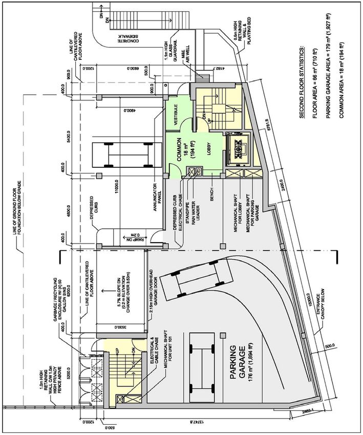
3.0   Section 3

      3.1    Minor Variance                                                      30
             3.1.1 Minimum Parking Rate                                          30
             3.1.2 Reduced Aisle & Driveway Width                                30
             3.1.3 Location of Parking & Loading Space                           31
             3.1.4 Exterior Garbage & Recycling Enclosure Location               32
             3.1.5 Minimum Width of Landscape Area Abutting a Residential Zone   33
             3.1.6 Minimum Width of Landscape Area Around a Parking Lot          34
             3.1.7 Site Plan                                                     35

      3.2    Conclusion                                                          35
             3.2.1 Further Information                                           35

                                          3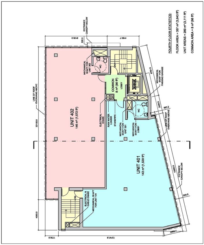
Section 1

1.1   Introduction

      1.1.1   Project Description

              This design brief has been prepared in support of the site plan application being submitted for a
              proposed 4-storey mixed-use medical/office building to be constructed at 1637 Bank Street, Ottawa.
              The design brief seeks to illustrate and explain how the architectural design conforms to the City of
              Ottawa’s relevant plans, studies and policies for the subject site, which is legally defined as: Part of
              Lots 453 & 454 (East Bank Street), City of Ottawa – Pin 04149-0049 under Registered Plan M-23
              dated February 10, 2014 and revised June 15, 2015.

              The 1,010m2 (0.101 hectare) site is located at the corner of Bank Street and Collins Avenue, and
              the vision for the proposed 1,232m2 (13,261ft2) gross floor area development is to create a strong
              architectural form with a blended massing of transparent and opaque building materials that anchors
              this highly visible urban streetscape. The site is steeply sloped along Collins Avenue and the intent
              is to utilize this grade change to transition from a 4-storey building facing Bank Street to a 3-story
              building abutting the neighbouring residential properties, while at the same screening the required
              parking through the building form along Bank Street.

1.2   Official Plan

      1.2.1   Objective

              The City of Ottawa Official Plan designation for the property is General Urban Area – Arterial
              Mainstreet, and the subject Zoning Designation under the City of Ottawa Zoning Bylaw is AM1
              [1913] - Sector ‘C’. The site at present is vacant and the proposed development seeks to intensify
              the corner site through the construction of a proposed 4-storey mixed-use medical/office building
              containing a walk-in clinic on the ground floor and an x-ray imaging lab on the third floor. An
              enclosed parking garage accessed off Collins Avenue would occupy the second floor, while the
              fourth floor would be leased to a tenant offering a related medical/office service. The area in front of
              the building along the Bank Street Right of Way (ROW) would be a pedestrian-friendly zone with a
              mixture of soft and hard landscaping, as well as visible and physical connections to the existing
              sidewalks and access points on the site. These landscape components would then continue up
              Collins Avenue to provide a soft transition and pedestrian linkage to the adjacent residential
              properties, while also screening the rear parking lot from view. The 4-storey Bank Street façade
              would present a continuous built-form of alternating patterns of wall and glass elements with soft
              accent lighting and canopies over the building entrances.

                                                         4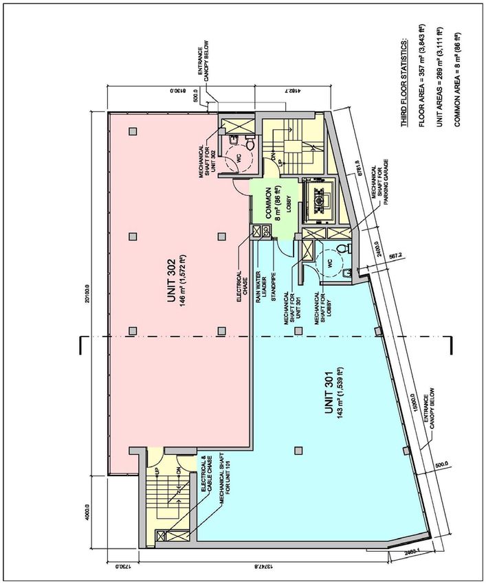
1.2.2   Building Liveable Communities Strategic Direction

        The proposed mixed-use development has been designed to respect and enhance both the
        commercial strip of Bank Street and the adjacent neighbouring residential properties. This has been
        achieved by capping the building height at 4-storey when 6-storeys could have been accommodated
        along Bank Street, and using a balance of precast stone panels and glass for the building facades.
        The building’s primary façade along Bank Street has been designed with a series of solid and
        transparent masses and planes to create a vibrant streetscape, and is anchored on the Bank Street
        and Collins Avenue intersection by a prominent building form that acts as a visual anchor for the
        building for pedestrians and motorists alike. The upper floor levels of the building have also been
        setback 12.0m from the rear lot line and capped at an 11.0m building height measured from
        average grade to provide adequate separation from the smaller residences.

        The proposed development is compatible to its urban surroundings while at the same time
        expressing its unique identity through the architectural form and materiality. The intensification on
        the vacant lot relates to the intent of Section 2.2.5 of the City of Ottawa Official Plan, which states:
        “In general terms, compatible development means development that, although it is not necessarily
        the same as or similar to existing buildings in the vicinity, nonetheless enhances an established
        community and coexists with existing development without causing undue adverse impact on
        surrounding properties. It ‘fits well’ within its physical context and ‘works well’ among those functions
        that surround it.” Furthermore, the building design meets the Design Objectives and Principles of
        Section 2.2.5 of the City of Ottawa Official Plan in accordance with Section 4.11 – Urban Design
        and Compatibility and Annex 3 of the Official Plan, which are described in greater detail in Section 2
        of this document.

        The proposed architectural design in conjunction with the landscape and civil engineering design
        meets Items 1 through 7 of Section 2.2.5 - Design Objectives and Principles of the City of Ottawa
        Official Plan by first creating a place with a distinct architectural identity that “reflect a thorough and
        sensitive understanding of place, context and setting.” The development provides a public space
        with hard and soft landscapes materials and retaining walls acting as benches along the Bank
        Street façade that “enhance and enliven the quality, character and spatial delineation of public
        spaces” and “encourage a continuity of street frontages.” The design provides highly visible and
        accessible public entrances to the building with appropriate signage and lighting that “create places
        and spaces that are visible and safe and can be confidently used at all hours of the day and at night
        where it is appropriate to do so,” and meets the intent of Policy 1 under Section 4.8.8 – Personal
        Security of the City of Ottawa Official Plan.

        The existing site is vacant and the proposed development will “complement and enliven the
        surroundings” through a smaller massing form and materials that are of a complimentary use to the
        neighbouring residential properties. Similarly, the floor plans have been designed as open floor
        plates with the building services grouped to “provide flexibility for buildings and spaces to adapt to a
        variety of possible uses in response to changing social, economic and technological conditions.”
        And finally, the associated engineering design will “demonstrate that all practical means of retaining
        stormwater on site have been considered” and will “maximize energy-efficiency and promote
        sustainable design to reduce the resource consumption, energy use, and carbon footprint of the
        built environment.”

                                                    5
1.2.3   Managing Growth Strategic Direction

              The proposed development and urban intensification on the vacant lot relates to the intent of
              Section 2.2.2 of the City of Ottawa Official Plan, which states: “Within lands designated General
              Urban Area, opportunities for intensification exist and will be supported,” and “by directing major
              intensification to the Central Area, along Mainstreets, and within Mixed-Use Centres and Town
              Centres in association with the transportation network, the stability of neighbourhoods within the
              General Urban Area is enhanced.” In addition, the intensification will create employment in the
              medical field with the mixed-use medical/office building, which meets the objectives of Policy 21
              under the 2.2.2 - Employment Section of the City of Ottawa Official Plan and Figure 2.3 – Density
              Targets by providing a minimum 12 net density jobs/gross hectare for the 1,010m2 (0.101 hectare)
              site.

      1.2.4   Maintaining Environmental Integrity Strategic Direction

              Please refer to the corresponding civil engineering plans and reports prepared by D.B Gray
              Engineering Inc., and the corresponding traffic study prepared by D.J. Halpenny & Associates Ltd.
              accompanying the site plan application.

      1.2.5   Providing Infrastructure Strategic Direction

              Please refer to the corresponding civil engineering plans and reports prepared by D.B Gray
              Engineering Inc. accompanying the site plan application.

1.3   Arterial Mainstreet Urban Designation
      1.3.1   Objective

              The proposed development and urban intensification on the vacant lot relates to the intent of City of
              Ottawa Official Plan and Section 3.6.3 of the Mainstreet Urban Designation, which states: “Over
              time, it is the City’s intent that Mainstreets will achieve more compact, mixed-use, pedestrian-
              orientated patterns,” and “… this Plan encourages intensification along Mainstreets. Intensification is
              most likely to occur through the redevelopment of such sites as vacant lots.”

      1.3.2   Mainstreet Principle

              The proposed mixed-use medical/office program addresses Item 3 under Section 3.6.3 of the
              Mainstreet Urban Designation, which states: “… a broad range of uses is permitted on Traditional
              and Arterial Mainstreets, including retail and service commercial uses, offices, residential and
              institutional uses.” In addition, the proposed building program creates a node of medical-related
              uses serving the commercial Bank Street corridor and surrounding residential neighbourhoods with
              the existing pharmacy located across Collins Avenue from the site.

              The proposed building form with a continuous streetscape along Bank Street and pedestrian access
              to the building at grade addresses the intent of Item 8 under Section 3.6.3 of the Mainstreet Urban
              Designation, by providing “… a building format that encloses and defines the street edge and
              provides direct access to the sidewalk.”

                                                        6
1.4   Bank Street Secondary Plan & Community Design Plan

      1.4.1   Objective

              The site is located near the intersection of Heron Road and Bank Street and is situated in the
              Connecting Area just outside of the boundary of Node 2 as identified on the Bank Street CDP
              Secondary Plan – Volume 2A - Appendix A – Land Use. The proposed development promotes the
              three key visions identified under Section 1.3 – Vision and Design Principles of the Bank Street
              Secondary Plan and Section 3.1 – CDP Vision and Design Principles of the Bank Street Community
              Design Plan by providing a mixed-use development that is accessible by both pedestrians and
              automobiles alike, and that creates a new urban streetscape on the previously vacant lot.

      1.4.2   Built Form Principle

              The proposed building has been designed at 4-storeys to respect the scale of the neighbouring
              residential properties while at the same time providing a strong built-form along the Bank Street
              streetscape to meet the objectives of Section 1.4 – General Land Use and Design Policies of the
              Bank Street Secondary Plan and Section 5.1 – General Land Use and Design Guidelines of the
              Bank Street Community Design Plan. Specifically the building height and floor space index (FSI)
              respect Items 2 to 4 of the Built Form Section of both plans, as well as the zoning provisions for
              maximum building height and floor space index as identified under the City of Ottawa Zoning Bylaw
              - AM1 [1913] Zoning Designation. This includes a maximum building height of 11.0m measured
              from average grade for a distance of 20.0m from the adjacent R2F residential zoning, and a
              proposed FSI of 1.27.

              Please note that in order to provide vehicular access off Collins Avenue to the proposed parking lot
              located in the rear yard as required by Item 1 of the Parking and Access Section of the Bank Street
              Secondary Plan and Bank Street Community Design Plan (see Item 1.4.4. below for further
              clarification), the second floor level is proposed at 2.9m above the Bank Street sidewalk. This height
              above grade cannot be increased as the resulting driveway accessing the parking lot from Collins
              Avenue would be too steep relative to municipal standards. As a result, the desired 4.5m ceiling
              height for the ground floor space as identified in Item 5 of the Built Form Section of the Bank Street
              Secondary Plan and Item 7 of the Built Form Section of the Bank Street Community Design Plan
              cannot be achieved and a finished ceiling height of 3.0m has been proposed instead. This ceiling
              height is sufficient for the proposed walk-in clinic occupying the space, and to achieve this height
              the ground floor slab is proposed at 0.55m below the exterior grade. Pedestrians entering the
              building would enter the building lobby at grade and descend to the lowered floor slab via a
              generous barrier-free 1:12 ramp and stairs located within the unit. Similarly, the upper floor levels
              have a proposed finished ceiling height of 2.5m instead of the desired 4.5m, which is a sufficient
              height for the intended mixed-use medical/office occupancies. If this height were too be increased
              then the overall building height would exceed the maximum 11.0m building height as noted in the
              AM1 [1913] Zoning Designation.

                                                        7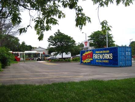
1.4.3   Design Principle

              The proposed building design conforms to the required building setbacks as identified under the City
              of Ottawa Zoning Bylaw - AM1 [1913] Zoning Designation, as well as Item 3 of the Design Section
              of the Bank Street Secondary Plan and Item 4 of the Design Section of the Bank Street Community
              Design Plan. The required 37.5m Bank Street Right of Way (ROW) width and 5.0m Hydro Ottawa
              overhead clearance from the adjacent high voltage power lines have been provided. In addition, the
              building elevations along both Bank Street and Collins Avenue have been designed with visible
              barrier-free entrances and varying architectural materials treatments and massing not exceeding
              15.0m in length to meet the objectives of Items 4 & 5 of the Design Section of the Bank Street
              Secondary Plan and Items 2 & 5 of the Design Section of the Bank Street Community Design Plan.
              Low-growing maple trees and other vegetation are proposed along Bank Street and Collins Avenue
              as per Items 10 and 11 of the Design Section of the Bank Street Secondary Plan and Item 10 of the
              Built Form Section of the Bank Street Community Design Plan in order to help enliven the building
              façade and screen the parking lot from view. This also adds “character, identity and distinction to
              Bank Street as an important pedestrian and automobile route,” and meets the intent of Policy 7
              under Section 4.3 - Walking, Cycling, Transit, Roads and Parking Lots of the Official Plan.

      1.4.4   Parking and Access Principle

              The required parking for the site has been provided via an asphalt parking lot with 14 parking
              spaces located to the rear of the property and accessed off of Collins Avenue, and an enclosed
              parking garage with 6 spaces accessed from the rear lot. All the parking is screened from view by
              the building massing along Bank Street and by landscape elements consisting of trees and
              plantings along Collins Avenue and a 2.0m high privacy fence where abutting the neighbouring
              residential properties in conformance to Items 1 & 3 of the Parking and Access Section of the Bank
              Street Secondary Plan and Bank Street Community Design Plan.

      1.4.5   Node 2: Heron Road Principle

              While the site is located outside of the Node 2 boundary on the east side of Bank Street, the
              proposed development seeks to reinforce the objectives of Section 1.5.2 – Node 2: Heron Road of
              the Bank Street Secondary Plan and Section 5.2.2 – Node 2: Bank Street and Heron Road of the
              Bank Street Community Design Plan by providing a mixed-use development with “a continuous
              streetscape and strong street edge along Bank Street.”

1.5   Contextual Analysis
      1.5.1   Description

              Within a 100 metre radius of the site located at 1637 Bank Street are a collection of commercial and
              residential properties with AM and R2F Zoning Designations. This area is roughly bounded by the
              commercial properties of Bank Street and Wildwood Avenue to the west of the site, the mixed-use
              commercial and residential properties located to the north of the site up to Heron Road, the mixed-
              use commercial and residential properties located to the south of the site up to Ridgemont Avenue,
              and the residential properties located to the east of the site towards Edge Hill Place along Anoka
              Street, Collins Avenue and Ridgemont Avenue.

                                                       8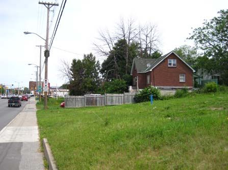
The commercial properties located along the Bank Street corridor and within the 100 metre radius of
        the site include: small independent restaurants, a fast food franchise (Tim Horton’s), two gas
        stations (Esso & Canadian Tire), service and retail businesses, a pharmacy (IDA), and a large
        retailer (Canadian Tire). There is also a multi-unit medical centre (Canada Care Medical Centre)
        located just outside the 100m radius to the south of the Canadian Tire off Wildwood Avenue. These
        buildings varying in height and scale, and are generally clad in metal or stucco and lacking in any
        significant or noticeable architectural treatment. They are generally characterized by multiple
        signage elements, visible parking along Bank Street, and minimal landscape elements.

        The residential properties are generally single family residences of 1 to 2–storeys in height, and
        varying in age from older post-war constructions to more recently renovated properties. The
        residences are for the most part clad in masonry veneer or horizontal siding and a very well
        maintained with landscaped yards. Bank Street is a large arterial mainstreet with OC Transpo
        service on both sides of the street, and high voltage power lines running down the east side of the
        roadway. The local streets are without sidewalks but are fronted by mature trees along their
        respective lengths.

1.5.2   Context Map

                                                 9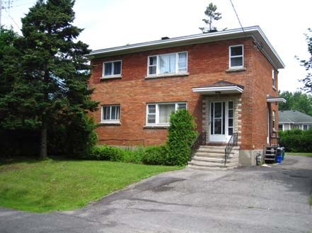
1.5.3   Site Photographs

        Site Photograph No. 1        Site Photograph No. 2

        Site Photograph No. 3        Site Photograph No. 4

        Site Photograph No. 5        Site Photograph No. 6

                                10
Site Photograph No. 7 Site Photograph No. 8
Site Photograph No. 9 Site Photograph No. 10
Site Photograph No. 11 Site Photograph No. 12
11Site Photograph No. 13 Site Photograph No. 14
Site Photograph No. 15 Site Photograph No. 16
Site Photograph No. 17 Site Photograph No. 18
12Site Photograph No. 19 Site Photograph No. 20
Site Photograph No. 21 Site Photograph No. 22
Site Photograph No. 23 Site Photograph No. 24
131.5.4 Analysis
The proposed mixed-use development has been designed to act as a prominent focal element for
this portion of Bank Street due to occupying a prominent corner lot, and in the absence of any
unifying or significant architectural features present in the existing buildings. The proposed
architectural design has an architectural form and material palette that blends the two different
surrounding zones. It respects the smaller massing and cladding of the residential properties to the
north, south and east through an 11.0m building height measured from average grade, and with an
exterior cladding of precast stone panels to reference the masonry veneer of the adjacent
residences. The windows on the upper floor levels have also been reduced in size from a typical
floor to ceiling arrangement in commercial properties to a more modest opening with a sill height of
0.45m from the floor, and a finished ceiling height of 2.5m.
Similarly, the proposed design respects the commercial vitality of Bank Street by presenting a 4-
storey streetscape of the same glass and precast stone panels, and a generous pedestrian zone in
front of the building consisting of hard and soft landscaping materials. The parking for the site, which
is accessed off Collins Avenue and located level with the second floor of the building due to the
2.7m grade change on site from the front of the lot to the rear, is screened from view along Bank
Street by the building massing and landscape elements along Collins Avenue. Proposed signage
elements on the building would be limited to specific areas on the building façade so as to present a
clear and legible identity for the prospective tenants, while ensuring that the architectural design of
the building is not diminished or detracted by multiple signage. Exterior lighting will primarily be used
to accentuate the architectural features of the building, and to illuminate public areas and entrances
for safety and building wayfinding.
Bicycle parking has been provided with a single 2-station 5-capacity bicycle ring rack as per the City
Ottawa Zoning Bylaw Part 4 – Parking, Queuing and Loading Provisions and Section 111 - Bicycle
Parking Space Rates and Provisions and Table 111a (e) Area C. This ring rack is located on a well-
lit concrete pad situated adjacent to the vehicular entrance off Collins Avenue, which meets the
intent of Policy 6 under Section 4.3 - Walking, Cycling, Transit, Roads and Parking Lots of the City
of Ottawa Official Plan. However, should the City permit the bicycle parking to be located within the
Bank Street Right of Way (ROW) then it will be moved to the hard landscaped area beside the
principal entrance off Bank Street in order to be more visible and encourage cycling use to the
building.
14Section 2
2.1 Design Objectives and Principles
2.1.1 Urban Design and Compatibility Objective
Since the subject site connects a high-traffic commercial strip characterized by a range of building
types and sizes to a more modest low-scale residential neighbourhood of single family residences,
the proposed development and ensuing architectural design utilizes a number of strategies to bridge
these distinct zones as required by the City of Ottawa Official Plan and Section 4.11 – Urban Design
and Compatibility - Policies. All required building setbacks as identified under the AM1 [1913]
Zoning Designation have been provided, and this in turn has established a building footprint that
reflects the profile of the site while providing a 12.0m horizontal separation from the adjacent R2F
zoning and single family residences as intended by Items 2(d) and 2(h). This separation diminishes
shadows cast towards the neighbouring properties from the building volume during the late-
afternoon, while also providing a measure of privacy to their outdoor amenity areas and acoustical
separation from noise generated in the building. Lighting is typically downcast to avoid spill-off onto
the neighbouring residences, and the entire rear parking lot has been visually separated with a 2.0m
privacy fence and landscape materials to provide a visual and acoustical buffer in order to meet the
intent of Items 2(f) and 2(g).
Access to the site for vehicular traffic has been provided via Collins Avenue so as to not further
encumber Bank Street, and the maximum amount of area that can be used for on-site parking has
been utilized to mitigate against off-site parking along Collins Avenue in response to Item 2(b). This
parking has in turn been split between a surface lot and an enclosed parking garage so as to reduce
the amount of asphalt present on site as per the objectives of Item 2(c), while providing a building
mass that echoes the form and materiality of the upper floor levels above. Bicycle parking has been
provided on-site, and the building is serviced by the nearby Bank/Collins OC Transpo Bus Stop
#8435 on the east side of Bank Street, and Bank/Heron OC Transpo Bus Stop #8306 on the west
side of Bank Street.
The proposed mixed-use medical/office tenant mix under the banner “M3 Medical” will create a
designated health sector facility serving the Bank Street area, and the proposed architectural and
engineering design will conform to the 2012 Ontario Building Code and Energy Efficiency
requirements under MMAH Supplementary Standard SB-10 and ANSI/ASHRAE/IES 90.1 to meet
the intent of Items 2(i) and 2(j).
2.1.2 Building Profile & Transitions Principle
Under the City of Ottawa Official Plan, the proposed 4-storey mixed-use development is considered
low-rise as per Item 7(a) of Section 4.11 – Urban Design and Compatibility - Building Profile. To
help scale the building mass to the smaller 1 to 2-storey residential properties located to the east of
the property, the 2.7m grade change along Collins Avenue has been used to step the building
height from 4-storeys along Bank Street to 3-storeys at the rear of the property. This measure
ensures that there is a strong and visible building form along Bank Street, yet respects the
residential properties to the rear through a smaller 9.6m building height.
15The mass of the building volume is further scaled-down with the use of horizontal banding elements
that are clad with a precast stone panel between floors, and a continuous row of glazing on the
upper floor levels. These strong horizontal lines and continuous glazing act to counter the verticality
present in the tall corner element which holds the building’s core services (i.e. elevator, stairwell,
and service chases), and acts as an anchor on the highly visible corner site for vehicular traffic and
pedestrians alike. Horizontality is further expressed through colour-contrasting linear canopies
centered over the barrier-free pedestrian entrances to the building, horizontal metal siding around
the enclosed parking garage area, and through the building soffit which projects past the exterior
building face 0.15m. This colour-contrasted projection helps introduce depth to the façade, while
also providing a surface to mount down-cast accent lighting. Furthermore, the 13.65m high corner
element of the building is reduced in scale through the use of 0.6m wide horizontal precast stone
panels running in an alternating bond-pattern at varying lengths, varied retaining walls and steps
complete with glass and metal guardrails, and softened through the use and placement of low-
growing maple trees and vegetation planted along Bank Street and Collins Avenue. These
measures all seek to reinforce the policies of the City of Ottawa Official Plan and Item 12 under
Section 4.11 – Urban Design and Compatibility – Building Transitions.
Within the public realm of the building along Bank Street and a portion of the side elevation along
Collins Avenue are a collection of soft and hard landscape elements, which include planting beds
with brown cedar mulch, grassed areas, and low-growing trees and shrubs. These soft measures
seek to reduce the height of the 4-storey building relative to the Bank Street sidewalk, while also
providing an area of respite and shade for pedestrians either entering the building or passing by the
site. This is further supported by accessible sidewalks and 0.6m high retaining walls that double as
seats and edges for raised landscaped planting beds. The entrance canopies over the building
entrances seek to reduce the scale of the building for pedestrians, while providing a measure of
safety through under-canopy lighting. Along the Bank Street façade the ground floor level is
substantially glazed to provide a sense of openness to the public realm, as well as providing views
into and from the walk-in clinic located on the ground floor of the building. In addition, the hard
landscape plaza area located in front of the building at the Bank Street and Collins Avenue
intersection can double as a gathering space for both users of the building and community
members. To reduce the scale of this hard landscape, precast stone pavers are proposed in an
alternating running-bond pattern to reference the horizontal siding on the building and framed by
low-growing shrubs and flowers around the perimeter.
2.1.3 Annex 3 – Design Framework
The proposed architectural design and site development as detailed in Sections 1 and 2 of this
report are to be considered as meeting the intent and objectives of the City of Ottawa Official Plan
and Secondary Plans, and the following sampling of Annex 3 – Design Framework statements can
be considered as supporting that application.
Design Objective 1:
“Enhancing or creating nodes of activity within communities or districts at important junctions and
points of interaction where a distinctive urban design character is created, such as through the
erection of landmark buildings …”
“Incorporating architectural and functional excellence to create distinctive places, enhance local
identity, and assist in public interaction.”
16Design Objective 2:
“Addressing locations that abut a public space frequented by pedestrians by providing elements
such as: active, at-grade community-serving uses; at-grade entrances at frequent intervals;
windows giving views to passerby that both informs them of the function of the building and provides
views out of the building to enhance natural surveillance; colonnades, awnings or other features that
have the effect of widening the public space and/or providing weather protection to pedestrians; and
seating and related amenities at known waiting areas, points of interest, vistas or changes in grade.”
“Locating surface parking lots away from the street in rear or side yards… and screening them from
pedestrians.”
Design Objective 3:
“Providing the primary site and building access directly from the street in ways that are clearly
identifiable, barrier free and incorporate safe, attractive pedestrian routes.”
“Defining clear, continuous pedestrian circulation that does not conflict with vehicular movement.”
Design Objective 4:
“Considering infill and redevelopment as opportunities to enliven and create a sense of visual
interest and delight.”
“Addressing the impact of the height of medium / tall buildings by means such as: incremental
changes in height; providing substantial space separation or planting buffers; or using existing
topographical breaks or natural features ...”
Design Objective 5:
“Anticipating the infilling of vacant spaces in front of and between buildings with new development.”
Design Objective 6:
“Using plant materials to create transitions between urban development and adjacent natural areas
and open spaces and between existing and proposed development.”
“Incorporating green building technology to ensure resource efficiency, including the use of
recycled, renewable, and reused resources to the maximum extent practical.”
172.1.4 Building Massing
West Building Elevation (Bank Street)
South Building Elevation (Collins Avenue)
18East Elevation
North Elevation
Please refer further to Architectural Drawing A1.1 for a list of the exterior finish materials and
respective dimensions of each building element, and to Section 2.1.2 - Building Profile & Transitions
Principle in this document for a description of the measures used to transition to the adjacent
properties.
192.1.5 Building Context
Bank Street / Collins Avenue Intersection View
Bank Street View
Please refer further to Section 2.1.1 - Urban Design and Compatibility Objective and Section 2.1.2 -
Building Profile & Transitions Principle in this document for a description of how the proposed
building design responds to and relates to the existing context.
2.1.6 Building Transition
Please refer further to Section 2.1.2 - Building Profile & Transitions Principle in this document for a
further description of the measures used to transition to the adjacent properties.
202.1.7 Grading
The 2.7m grade change from Bank Street to the proposed driveway access off Collins Avenue has
been used to step the building height from 4-storeys along Bank Street to 3-storeys at the rear of
the property. This results in the parking allocation for the site being placed at the second floor level
in conformance to the Item 1 of the Parking and Access Section of the Bank Street Secondary Plan
and Bank Street Community Design Plan. The site section and rendered street profile image below
further illustrates this grade transition.
Site Section
Collins Avenue / Parking Lot Driveway
212.1.8 Alternative Building Massing
Prior to the involvement of Peter Mansfield Architect on this project, the drafting firm of Clear
Drafting Inc. explored the concept of a 6-storey building on the site (see Image No. 01 & 02). The 6-
storey building volume was aligned with Bank Street and extended back to the 20.0m setback from
the adjacent R2F residential zoning as required by the City of Ottawa Zoning Bylaw - AM1 [1913]
Zoning Designation for a building exceeding 11.0m in height. This scheme was not furthered
explored by Peter Mansfield Architect as the floor plates were seen as too small, and the proposed
height was seen as unsympathetic to the 1 to 2-storey residential properties to the east, and out of
scale with the 1 to 2-storey buildings along Bank Street in the general vicinity.
Under our direction, the proposed mixed-use medical/office building was reconsidered and
redesigned as a 4-storey building meeting the City of Ottawa Zoning Bylaw - AM1 [1913] Zoning
Designation. The resulting floor plates are more adaptable as they allow either a single or double
tenant arrangement, and the larger floor area is more efficient as stairwells and elevators do not
need to extend an extra 2 floor levels. Similarly, the structural system of reinforced concrete floor
slabs, shear walls and columns can be better accommodated and the structural loads better
distributed over the wider floor volume.
We initially proposed floor to ceiling glass and spandrel panels at the floor assemblies, and with a
large volume at the corner the 4-storey building (see Image No. 03). The colour scheme was white,
charcoal grey and burgundy but there was no specific material treatment identified for the corner
element. This scheme was presented to the City at the pre-consultation meeting, and following that
discussion we scaled back the amount of glazing and adopted a precast stone panel exterior of light
beige tones to connect to the materiality and colours of the neighbouring residential properties,
while introducing horizontality into the proposed design to help further reduce the scale of the
building thorough accented canopies, fascia, and material profiles.
1. Bank Street View (Courtesy of Clear Drafting Inc.)
222. Collins Avenue View (Courtesy of Clear Drafting Inc.)
3. Bank Street & Collins Avenue Intersection View
2.1.9 Relationship to the Public Realm
Please refer further to Landscape Drawing L1.0, Section 2.1.1 - Urban Design and Compatibility
Objective and Section 2.1.2 - Building Profile & Transitions Principle in this document for a
description of how the proposed building design responds to and relates to the public realm.
23Ground Floor Plan
24Second Floor Plan
25Third Floor Plan
26Fourth Floor Plan
27Roof Plan
282.1.10 Building Design
Please refer further to Architectural Drawing A1.1 for a list of the exterior finish materials and
respective dimensions of each building element, and Section 2.1.9 - Relationship to the Public
Realm in this document for the respective floor plans and dimensions.
Similarly, please refer further to Section 1.4.2 – Built Form Principle and Section 2.1.2 - Building
Profile & Transitions Principle in this document, as well as other parts as required, for a description
of the proposed building design and respective architectural features.
2.1.11 Sustainability
Please refer further to Section 2.1.3 – Annex 3 – Design Framework and Design Objective 6 in this
document for sustainable features to be incorporated into the building and landscape design.
29Section 3
3.1 Minor Variance
3.1.1 Minimum Parking Rate
Under the City of Ottawa Zoning By-Law Part 4 – Parking, Queuing and Loading Provisions and
Section 101 – Minimum Parking Space Rates, the proposed mixed-use medical/office building
requires 31 parking space consisting of the following:
Medical Facility (Ground floor & 3rd floor units): 612m² unit area / 100m² x 4 = 25 spaces as per
Urban Exception [1913] and Table 101 - Column III Area B – Clause (bo) – Medical Facility
Office (4th floor units): 289m² unit area / 100m² x 2 = 6 spaces as per Urban Exception [1913] and
Table 101 - Column III Area B – Clause (bw) – Office.
At present 20 parking spaces consisting of 19 regular spaces at 2.6m x 5.2m and 1 handicap space
at 3.9m x 5.2m have been provided on site, which results in a deficit of 11 spaces. Under the City of
Ottawa Zoning Bylaw and Urban Exemption [1913] for the site it states: “Despite any requirements
to the contrary, parking for a use required on one lot, may be located on another lot, but must be in
the same city block, or on a lot on the opposite side of the public street on which the use requiring
the parking is located.” There exists an opportunity to provide the additional 11 parking spaces
required through a cash in-lieu arrangement with the small 21 space Canadian Tire parking lot
located across Bank Street from the site. However, Bank Street is a very busy arterial mainstreet
and with the proposed mixed-use medical/office building generally serving an aging population or
persons with potential mobility issues it is generally not a desirable arrangement to have
pedestrians either crossing the busy roadway at their own risk, or alternatively having to walk 2
blocks north of the site to use the pedestrian crossing at the Heron Road intersection before then
walking back 2 blocks south.
Under Section 2.2.2 – Managing Growth Within the Urban Area of the City of Ottawa Official Plan, it
states: “To promote compact, mixed-use development and achieve the density targets,” and notes
under Clauses13 (d) and 13(e) that the City will “… consider how to reduce the amount of land used
for parking, through such measures as reductions in parking standards” and “establish maximum
limits for the provision of on-site parking, consider waiving minimum parking requirements,
maximize opportunities for on-street parking, and consider target designations as priorities for the
creation of municipal parking structures.” Since the strategic direction and policies of the City of
Ottawa Official Plan allow for such reductions, it is hoped that the parking rate required for the site
can be set at 20 spaces in order that a cash in-lieu arrangement is not required with the commercial
property located across Bank Street.
3.1.2 Reduced Aisle & Driveway Width
Under the City of Ottawa Zoning By-Law Part 4 - Parking, Queuing and Loading Provisions and
Section 107 – Aisle and Driveway Provisions and Clause 107(1)(a)(ii), a driveway providing access
to a parking lot or parking garage must have a minimum width of 6.7m for a double traffic lane.
30In order to provide as many on-site parking spaces as possible to service the building as per Item
3.1.1 – Minimum Parking Rate above, and to mitigate against potential off-site street parking in the
neighbouring residential areas, the proposed site plan proposes a 6.2m aisle and driveway width for
a double traffic lane serving the rear parking lot and parking garage. Under Section 2.2.2 –
Managing Growth Within the Urban Area of the City of Ottawa Official Plan and Clauses 13(d) and
13(e), it states that the City will “… consider how to reduce the amount of land used for parking,
through such measures as reductions in parking standards” and “establish maximum limits for the
provision of on-site parking, consider waiving minimum parking requirements, maximize
opportunities for on-street parking, and consider target designations as priorities for the creation of
municipal parking structures.” Since the strategic direction and policies of the City of Ottawa Official
Plan allow for such reductions, it is hoped that a reduced aisle and driveway width of 6.2 m will be
permitted for a double traffic lane accessing the rear parking lot and parking garage.
Further to that request, the Architectural Drawings 1/A1.0 and 3/A1.0 show a series of 5.1m x 1.8m
passenger vehicles accessing the rear parking lot and parking garage spaces. The 6.2m aisle and
driveway width accommodates the required turning radius for this typical passenger vehicle as
shown and generated by AutoTurn software. Furthermore, where wall projections or structural
columns are located to the edges of required parking spaces the minimum parking width of 2.6m x
5.2m has been provided from this potential obstruction so as to ensure ease of turning into and out
of the space as required by the City of Ottawa Zoning Bylaw Part 4 - Parking, Queuing and Loading
Provisions and Section 106 – Parking Space Provisions and Clause (4).
Should the reduced 6.2m driveway and aisle width not been seen as a favourable or a practical
measure for the 20 parking spaces, Clause (3)(a)(i) under the City of Ottawa Zoning By-Law Part 4
– Parking, Queuing and Loading Provisions and Section 106 – Parking Space Provisions states that
“up to 40% of the required parking spaces may be reduced to a minimum width of 2.4 metres and a
minimum length of 4.6 metres … where the parking spaces are located in a parking lot or parking
garage containing more than 20 spaces.” While the 8 parking spaces located along the eastern
parking lot edge could be reduced in depth to 4.6m in order to provide a 6.7m aisle and driveway
width, it would actually hinder the flow and use of the lot by restricting larger passenger vehicles
from parking along this bank of spaces. This could potentially lead to off-site street parking in the
neighbouring residential areas or a constriction in the parking lot where the tail-end of a large
vehicle projects into the required aisle.
3.1.3 Location of Parking & Loading Space
Under the City of Ottawa Zoning Bylaw Part 4 - Parking, Queuing and Loading Provisions and
Section 109 – Location of Parking and Clause (2)(b), it states that “no person may park a motor
vehicle, in a required corner side yard.”
In order to provide as many on-site parking spaces as possible to service the building as per Item
3.1.1 – Minimum Parking Rate above, and to mitigate against potential off-site street parking in the
neighbouring residential areas, the proposed site plan proposes that 2 parking spaces be located
beyond the exterior face of the building along Collins Avenue where the minimum corner side yard
setback is 0.0m under the AM1 [1913] Zoning Designation for the site. Under Item 4 of the Parking
and Access Section of the Bank Street Secondary Plan and Bank Street Community Design Plan, it
states “parking may be permitted in side yards if the subject property is too shallow to allow for rear
yard parking or if not all required parking can be accommodated in the rear yard.”
31Since the guidelines of the Secondary Plan and Community Design Plan allow for such parking
arrangements, and because all available area in the rear yard is presently allocated to parking and
other site amenities, it is hoped that such parking can remain as detailed on the site plan so as to
not lose additional parking which is already at a deficit on site as detailed in Item 3.1.1 – Minimum
Parking Rate above. To buffer the two parking spaces from the street, the area would be screened
from view along Collins Avenue through soft and hard landscaping elements including low-growing
trees and shrubs, and with a guardrail/retaining wall feature beside the building entrance.
Under the City of Ottawa Zoning Bylaw Part 4 - Parking, Queuing and Loading Provisions and
Section 113 – Loading Space Rates and Provisions and Table 113B - Clauses (5)(c), (5)(d)(ii) &
(5)(e), it states that the minimum loading space must be 3.5m x 7.0m when accessed from a 6.0m
double traffic lane width and with a 4.2m high vertical clearance. Furthermore, under Table 113B –
Clause (5)(f), it states that a loading space is “permitted in all locations other than in a required front
yard or required corner side yard, or in a required yard abutting a residential zone.”
To provide the required single loading space as required by the City of Ottawa Zoning Bylaw Part 4
- Parking, Queuing and Loading Provisions and Section 113 – Loading Space Rates and Provisions
and Table 113A – IV for the proposed 1,232m2 (13,261ft2) gross floor area, one of the parking
spaces located in the corner side yard above is proposed to double as a loading space for the
building. Under Item 4 of the Parking and Access Section of the Bank Street Secondary Plan and
Bank Street Community Design Plan, it states “parking may be permitted in side yards if the subject
property is too shallow to allow for rear yard parking or if not all required parking can be
accommodated in the rear yard.” Since the guidelines of the Secondary Plan and Community
Design Plan allow for such parking arrangements, and because the proposed occupancies are all of
a medical/office nature with occasional deliveries via small cube vans and parcel delivery vehicles, it
is hoped that the oversized 3.5m x 5.2m parking space located beside the parking lot building
entrance and with a 2.7m height clearance can double as a parking and loading space for the
building so as to not eliminate one of the required parking spaces from the rear parking lot.
3.1.4 Exterior Garbage & Recycling Enclosure Location
Under the City of Ottawa Zoning Bylaw Part 4 - Parking, Queuing and Loading Provisions and
Section 110 – Landscaping Provisions for Parking Lots and Clause (3)(b), an exterior garbage
enclosure must be located at least 3.0m from any other lot line.
The garbage and recycling generated by the building tenants is proposed to be contained outside
the building along the interior side lot line in four 50 gallon plastic bins with lids. These bins are to be
screened from view behind a 2.0m high privacy fence and located 12.7m away from the rear lot line
and neighbouring residential property as per the City of Ottawa Zoning Bylaw Part 4 - Parking,
Queuing and Loading Provisions and Section 110 – Landscaping Provisions for Parking Lots and
Clause (3)(c). However, the proposed 3.7m x 1.0m garbage enclosure is proposed to be located
only 0.5m from the adjacent interior side yard lot line shared with the neighbouring property. Since
the exterior garbage and recycling enclosure will be screened by a 2.0m high privacy fence, the
building will only be serving medical-related occupancies with minimal food waste and related
odours, and the neighbouring property to the north will be developed as a commercial property in
the future, it is hoped that the enclosure will be permitted in this location. Furthermore, if the
enclosure must be located 3.0m from the interior side yard lot line then it will result in the loss of a
parking space, which is already at a deficit on site as detailed in Item 3.1.1 – Minimum Parking Rate
above.
323.1.5 Minimum Width of Landscape Area Abutting a Residential Zone
Under the City of Ottawa Zoning Bylaw Part 10 – Mixed-Use / Commercial Zones and Section AM –
Arterial Mainstreet - Table 185 - Clause (3)(h)(i), a 3.0m minimum width of landscape area must be
provided around a parking lot when abutting a residential zone.
In order to provide as many on-site parking spaces as possible to service the building as per Item
3.1.1 – Minimum Parking Rate above, and to mitigate against potential off-site street parking in the
neighbouring residential areas, the proposed site plan shows a proposed 1.5m width of landscape
area abutting the rear yard lot line and neighbouring residential zone. Under the City of Ottawa
Zoning Bylaw Part 4 - Parking, Queuing and Loading Provisions and Section 110 – Landscaping
Provisions for Parking Lots and Table 110 - Clause 1(b) – III, a 1.5m minimum width of landscape
area must be provided around a parking lot not abutting a street and containing more than 10 but
fewer than 100 spaces.
33Since the zoning provisions for landscape areas around a parking lot not abutting a street allow for a
smaller landscape area, it is hoped that the reduced 1.5m width of landscape area will permitted
along the eastern edge of the parking lot which contains 14 parking spaces. To buffer the parking lot
from the neighbouring residential property the reduced landscape area would be screened from
view by 2.0m high privacy fence.
3.1.6 Minimum Width of Landscape Area Around a Parking Lot
Under the City of Ottawa Zoning Bylaw Part 4 - Parking, Queuing and Loading Provisions and
Section 110 – Landscaping Provisions for Parking Lots and Table 110 - Clause (1)(b) – III, a 1.5m
minimum width of landscape area must be provided around a parking lot not abutting a street and
containing more than 10 but fewer than 100 spaces.
In order to provide as many on-site parking spaces as possible to service the building as per Item
3.1.1 – Minimum Parking Rate above, and to mitigate against potential off-site street parking in the
neighbouring residential areas, the proposed site plan shows a proposed 0.5m width of landscape
area abutting the interior side yard lot line and neighbouring property. Under the AM1 [1913] Zoning
Designation for the site, the interior side yard setback is 0.0m, and the northern exterior building
face has been setback 0.38m from the lot line. Since the proposed building face is located closer to
the lot line than the parking area, it is hoped that the reduced 0.5m width of landscape area will
permitted along the northern edge of the parking lot which contains 14 parking spaces. To buffer the
parking lot from the neighbouring property the reduced landscape area would be screened from
view by a 1.0m concrete retaining wall with a 1.0m high privacy fence above.
343.1.7 Site Plan
3.2 Conclusion
3.2.1 Further Information
We trust the information above is sufficient. Should you have any questions with respect to any of
the items addressed please feel free to contact us at your convenience.
Sincerely,
Peter Mansfield, O.A.A. Architect Tom Bonhomme, M.Arch.
Peter Mansfield Architect Peter Mansfield Architect
pmansfield@bellnet.ca tom@pmansfieldarchitect.ca
35You can also read