Discover Wayne County Trails - This Passport: Revised April 2021, ME 4574168 - Wegmans
←
→
Page content transcription
If your browser does not render page correctly, please read the page content below
This Passport: Revised April 2021, ME 4574168

                                                Discover Wayne County Trails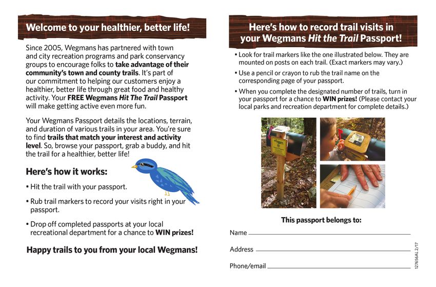
How to Use the Book
Wayne County invites you to explore and experience our region’s
diverse outdoor adventures! Here’s your opportunity to discover the
beauty and solitude of nature, a variety of wildlife, the magnificence
Wayne County
of natural invites
settings youhealth
and the to explore
benefitsandof experience
being moreour region’s
active all in Trail names can be found, in alphabetical order, at the top of the
diverse
your own outdoor adventures!
“backyard!” Share Here’s your opportunity
the wonders of the greattooutdoors
discoverwith
the
page. Underneath you will find a series of symbols, letting you
beauty
family and solitude
friends andof nature,
get to aknow
variety of wildlife,
your region up theclose
magnificence
and per- know what activities can be done on the trail.
of natural settings and the health benefits of being more active all in
sonal.
your own “backyard!” Share the wonders of the great outdoors with
The maps have all been carefully researched and plotted. If you
family and friends
The Wayne Countyand get to know
Wegmans your
Hit the Trailregion up close
Passport and runs
program per-
find an error, please email us at trailworks@trailworks.org. All
sonal.
continuously. In order to enter for the chance to win a $250 maps have north facing up, but an N arrow has been provided.
Wegmans gift card, you need to complete 15 of the 30 trails in the
The Wayne
booklet County
fill out the form in the Hit
Wegmans backtheof
Trail
thisPassport
book, and program
bring itruns
to The informational pages let you know how long the trail is, how far
continuously.
Cornell Cooperative Extension on Rt. 88 in Newark. If youa com-
In order to enter for the chance to win $250
from the parking lot to the passport, and the features of the trail,
Wegmans
plete all 30gift card,
trails, youyou
willneed
haveto2complete
entries in15 theofdrawing.
the 30 trails
The in the
draw- such as what natural features you might expect to find, such as
booklet
ing will fill
be outheldthe form in
annually onthe back ofTrails
National this book, and your
Day, and bring entry
it to
plants and birds.
Cornell
remains Cooperative
in the pool. Extension on Rt. 88 in Newark. If you com-
plete all 30 trails, you will have 2 entries in the drawing. The draw-
The page also provides the difficulty, with one-star trails
ing
Anywill
Download be the
questions: heldcontact
annually
free us on
phone National
app
through Trails
TrailDay,
Hitourthewebsite Wayneand County
your entry
www.trailworks.org, for being flat and easy. Two stars might be a little more chal-
remains in the pool.
added fun and adventure! Available for iPhone and Android.
or email trailworks@trailworks.org. lenging, and be prepared to break a sweat with three stars!
Trails with the above icon are designated “Forever Wild For Every-
Any questions:
Hiking tips: contact us through our website www.trailworks.org, one” accessible trails.
or email trailworks@trailworks.org.
Please observe posted regulations on all pathways
Bring a buddy or tell someone of your plans Lastly, we provide some directions on how to start your hike from
Hiking tips:
the parking lot, and some tips and tricks, such as letting you know
Bring bug
Please repellent
observe andregulations
posted water (stayon
hydrated)
all pathways what you can expect on the trails, and what else you can find in the
Wear weather
Bring a buddy appropriate clothing
or tell someone andplans
of your footwear area. (We also include information on “comfort stops,” which may
be closed during the winter months.)
yourrepellent
Bring bug Wayne County
and waterWegmans Hit the Trail Passport and
(stay hydrated)
a pencil or crayon for the rubbing What you are looking for is a four-foot-tall post with an angled
Wear weather appropriate clothing and footwear
Bring your Wayne County Wegmans Hit the Trail Passport and head (see the picture on page 34
32). This is the passport marker that
a pencil or crayon for the rubbing you are looking for. Be sure to bring a pencil or crayon with you,
1 2
Trail Works Membership
and make a rubbing in the blank area to prove that you visited the
trail and found the marker. Once you have achieved 15 rubbings,
you can turn in half of the back page to Cornell Cooperative Exten-
sion (1581 Rt. 88 North, Newark), or mail to us at Trail Works (PO Trail Works is a nonprofit organization dedicated to being a unified
Box 4341, Williamson, NY 14589). This will enter you into a $250 voice for Wayne county trail users and to coordinate the develop-
Wegmans gift card drawing. We draw for the winner on National ment and maintenance of high quality, year round, multi-use trails.
Trails Day, so be sure to include a way to reach you. Please consider joining Trail Works, Inc. as a member. Your dues
help us to embody public education about trails and increase public
But hiking the trails isn’t just about winning prizes. It is about ap- awareness of trail issues. We strive to preserve Wayne County herit-
preciating all that nature has to offer. You can enjoy the time spent age and green spaces for the enjoyment and recreation of our future
with others, or just appreciate the solitude in this fast-paced world. generations.
We hope you enjoy hiking the trails as much as we enjoyed putting
this book together for you. Welcome to Wayne County—let’s “hit
Please check the type of membership:
the trails!”
single ($15)
YOUR FRIENDS AT TRAIL WORKS
corporate ($50)
family (# of family members: ______ ) ($25)
Icon Legend
Name: __________________________________________
kayak/boat launch snowmobiles allowed
Address: ________________________________________
City: ________________ State: ______ Zip: ___________
equestrian trail cross-country skiing
Phone: ( ) ________________________________
bike-friendly trail camping allowed Email: __________________________________________
geocaching Please return this completed page with your check, or visit
birdwatching
www.trailworks.org to join online.
3 4Index of Trails
Alasa Farms 8 Kraai Preserve 42
Beechwood State Park 10 Lauraville Landing 44
Bicentennial Trail 12 Lockville 46
Black Brook Park 14 Montezuma Audubon 48
Blue Cut 16 Palmyra Wetland 50
Butterfly Nature 18 Richmond Aqueduct 52
Casey Park 20 Sherburne Park 54
Chimney Bluffs Park 22 Sodus-Wallington 56
Cornwall Preserve 24 Third Creek 58
Crowfield Sanctuary 26 Trail of Hope 60
Dolomite Trail 28 Turtle Pond 62
Enlarged Erie Lock 56 30 West Shore Trail 64
Ganargua Creek Meadow 32 Whistlewood 66
Historic Lyons 34 Williamson Town Loop 68
Huckleberry Swamp 40 Wolcott Falls 70
5Lake Ontario
Lake Ontario
104
104
350 104
350 104
88 89
21 88 414 89
21 14 414
14
31F 31
31F 31
31
31
W
Waay
ynnee C
Coou
unntty
y,, N
NYY
6Alasa Farms Trail
TRAIL LENGTH: 6.5 miles of trails
DISTANCE TO PASSPORT: About half a mile.
6450 SHAKER RD., ALTON NY 14413 FEATURES: Hiking, skiing and equestrian use, wildlife habitat con-
servation, natural and agrarian areas, friendly farm animals, historic
Shaker farm site. Self-guiding Farm Tour Booklets available on site.
Alasa Farms is preserved in partnership with Genesee Land Trust.
DIFFICULTY:
TRAIL HEAD: Head out from the parking lot. Parking is in the field
at the junction of Shaker and Red Mills Roads (seasonal) and be-
hind the bunkhouse at the main Farm entrance on the east side of
Shaker Road.
TIPS: Terrain ranges through open field edges to steep slopes and
narrow trails in the woods. Second Creek crossing is not bridged
and must be forded by walking in the creek on the bedrock stream-
bed. Restrooms are available.
8 9Beechwood State Park
TRAIL LENGTH: 3.1 miles of trails
DISTANCE TO PASSPORT: About half a mile.
7563 LAKE RD., SODUS NY 14551 FEATURES: Beechwood State Park offers numerous trails that wind
through an old Girl Scout Camp. The trails feature an old-growth
hardwood forest, White Pine and Larch Pine plantation, a meadow,
and a young growth hardwood forest. There are many beautiful
views of Lake Ontario and Maxwell Bay. Bald Eagles, Red-Tailed
Hawks, and numerous species of song birds and water fowl are
common sights in the park.
DIFFICULTY:
TRAIL HEAD: There are two options, east or west entrances. The
west entrance offers a level path to the passport marker, while the
east entrance will give you varying terrain but better views. Access
to Maxwell Bay is from the east entrance.
TIPS: Check in with caretaker for carry-in/carry-out camp-
ing. Restrooms are available.
10 11Bicentennial Trail
TRAIL LENGTH: 1.2 miles
DISTANCE TO PASSPORT: About 500 feet.
7614 MAKEN RD., WILLIAMSON NY 14589 FEATURES: Wooded area with added pond loop. Gentle trail
through mixed hardwood forest; some boardwalks.
DIFFICULTY:
TRAIL HEAD: Cross the small bridge by the parking area and follow
the tree line south.
TIPS: Stop for a rest on the beautiful bench at the south end, and
note all of the painted rocks and creativity around you. Be sure to
check out the pond loop!
12 13Black Brook Trail
TRAIL LENGTH: 2.75 miles linear
DISTANCE TO PASSPORT: About 1000 feet.
8472 OLD ROUTE 31, CLYDE NY 14433 FEATURES: A historic site on the Enlarged Erie Canal on over 20
acres. Wooded trail parallels sections of Clinton's Ditch and runs
adjacent to the Enlarged Erie Canal once it is crossed.
To arrive at the east/west Erie Canal Trail from Black Brook Park
parking lot, one must first traverse the bed of Clinton's Ditch and
then the bed of The Enlarged Erie Canal. The Enlarged Erie Canal
Lock 54, with its ruins and signage, is a must-see.
DIFFICULTY: “Forever Wild for Everyone” accessible trail
TRAIL HEAD: From the parking lot, head south.
TIPS: This is a designated Forever Wild for Everyone Trail for .6
miles from Gansz Rd. to the Passport Marker. Restrooms are avail-
able.
14 15Blue Cut Nature Center
TRAIL LENGTH: 1.5 miles of trails
DISTANCE TO PASSPORT: Less than half a mile.
7219 ROUTE 31 W., LYONS NY 14489 FEATURES: The name Blue Cut dates back to 1853 when a cut was
made through a drumlin while building the railroad. The Vernon
Shale had a bluish cast when exposed. Today this nature center and
wildlife refuge covers over 40 acres of open land with marsh and
pond, mixed hardwoods and red pine plantation. Surface: Dirt,
mowed-grass, and pine needle trails. There are 3 trails and multiple
end points in the trail system. End points on the map, should be
thought of as “dead ends.” The outer loop of the trail system,
which includes sections of each trail, will bring you right back to the
parking area.
DIFFICULTY:
TRAIL HEAD: Right off the parking lot, heading south.
TIPS: A new picnic pavilion has been added to the Nature Center.
Bring a picnic lunch and enjoy the serene setting! Restrooms are
available.
16 17Butterfly Nature Trail
TRAIL LENGTH: 1/4 mile
DISTANCE TO PASSPORT: 1/4 mile
ROUTE 350 AT ROUTE 31, MACEDON NY 14502 FEATURES: The Butterfly Nature Trail provides a place for all peo-
ple to enjoy the beauty of nature. The trail is a great educational tool
for butterflies, birds and the history of the Erie Canal. From one
vantage point all three eras of the canal system can be viewed. The
trail is next to free picnic areas, camping and launching for boats,
kayaks and canoes. Come enjoy this hidden treasure.
DIFFICULTY: “Forever Wild for Everyone” accessible trail
TRAIL HEAD: Set out from the parking lot. Take the southern path
to view the “three canals,” and the northern path to see Lock 30.
TIPS: The trail is a 10-15-minute walk to/from the central business
district with unique shops, easily accessed from the Erie Canalway
National Heritage Trail Corridor. Restrooms are available.
18 19Casey Park
TRAIL LENGTH: 2+ miles of trails
DISTANCE TO PASSPORT: less than 1/4 mile, on the park sign
6551 KNICKERBOCKER RD., ONTARIO NY 14519 FEATURES: The abandoned iron ore bed is a narrow waterway.
Hiking along the southern shore begins at the swimming area. The
wide path is packed dirt. At the west edge of the ore bed, the path
narrows and climbs to return on the north shore, high on a narrow
ridge.
DIFFICULTY:
TRAIL HEAD: Set out from the parking lot; the head of the south-
ern route can be found by the sign for the park, where the passport
marker is located.
TIPS: The south side of trail is wide dirt path, but north side of trail
traverses a narrow ridge. Care must be taken (no bicycles on the
north side). Kayak rentals are available on the southeast side of the
waterway. There are more trails at the west end of the iron ore bed,
after crossing Ontario Center Rd. Restrooms are available.
20 21Chimney Bluffs
TRAIL LENGTH: 2+ miles of trails
DISTANCE TO PASSPORT: Approx. 1 mile from west parking lot.
7700 GARNER RD., WOLCOTT NY 14590 FEATURES: Land and water clash at Chimney Bluffs, sculpting the
most dramatic landscape on the Lake Ontario shore. You can expe-
rience massive earthen spires from above or along the lakeshore.
DIFFICULTY:
TRAIL HEAD: Enter the trail from the lakeside park at the west end,
from Garner Rd., or from the parking area at the east end of the
Bluff Trail (steep hill).
TIPS: Chimney Bluffs is one of the best locations in Wayne County
to see spring wildflowers and view the sunset. Caution should be
exercised when near the Bluff’s edge. Recent erosion of lake prop-
erties have caused some trails to be re-routed. As Chimney Bluffs is
a state park, there is a $5 fee to park in the Garner Rd. parking area
from April 1-October 31. Restrooms are available.
22 23Cornwall Preserve
TRAIL LENGTH: approx. 1.5 miles each way
DISTANCE TO PASSPORT: Less than 2000 feet.
3975 LAKE RD., WILLIAMSON NY 14589 FEATURES: The 74 acre Cornwall Preserve was purchased by Gen-
esee Land Trust in 2016. This unique property encompasses 2/3
mile of natural lakefront on Lake Ontario, mature woodlands, a
wildflower meadow, and important migratory bird habitat. The
property surrounds the Historic Lakeview Cemetery and also in-
cludes active fruit farmland. The Preserve is open to the public
dawn to dusk, every day of the week, but closed on Wednesdays for
agricultural management.
DIFFICULTY:
TRAIL HEAD: Head north from the parking lot on Lake Rd.
TIPS: This trail also offers one of the best spots in the county to see
the sunset. The Meadow Trail and Lake Bluff Trail are rolling
grassy trails through a wildflower meadow and along Lake Ontario.
The Woods Trail is an enclosed trail through 13 acres of woodlands
with occasional roots and stones in the trail.
24 25C
Crroow
wffiieelldd SSaannccttuuaarryy
TTRAIL
RAILLLENGTH
ENGTH: : 3.5
3.5miles
milesof
oftrails
trails
DDISTANCE TOPPASSPORT
ISTANCETO ASSPORT: :Less
Lessthan
than2000
2000feet.
feet.
2480
2480AARCADIA
RCADIAZ URICHN
ZURICH NORRIS RD.,.,N
ORRISRD EWARKNY
NEWARK NY14513
14513 EATURES: : Nature
FFEATURES Nature trails
trails wind
wind through
through different
different types
types of of ecosys-
ecosys-
tems,
tems,which
whichinclude
includeaawetland,
wetland,aameadow,
meadow,and andaabeautiful
beautifuldeciduous
deciduous
hardwood
hardwood forest.
forest. Signage
Signage for
for species
species identification
identification isis located
located along
along
sections
sectionsof
ofthe
thetrails.
trails. So,
So,enjoy
enjoyyour
yourhike
hikeand
andkeep
keepyouryoureyes
eyesopen
open
for
for songbirds,
songbirds, mammals,
mammals, wildflowers,
wildflowers, andand other
other signs
signs of of Mother
Mother
Nature.
Nature.Great
Greattrails
trailsfor
forX-country
X-countryskiing.
skiing.
IFFICULTY: :
DDIFFICULTY
TTRAIL HEAD: : Look
RAIL HEAD Look forfor signs
signs for
for parking
parking off
off of
of Arcadia
Arcadia Zurich
Zurich
Norris
NorrisRd.;
Rd.;follow
followthe
thedrive
driveand
andpark
parkbybythe
thekiosk.
kiosk. Head
Headeast
eastfrom
from
the
thekiosk
kioskto
tothe
thetree
treeline.
line.
IPS: : Following
TTIPS Following the
the Blue
Blue Trail
Trail north,
north, and
and continuing
continuing on on the
the Red
Red
Trail,
Trail, offers a gentler approach to the passport marker than the
offers a gentler approach to the passport marker than the
steep
steep hill
hill by
by the
the kiosk
kiosk (which
(which isis aa fun
fun challenge).
challenge). Check
Check out
out
“Paula’s
“Paula’s Peppermint
Peppermint Trail”
Trail” on
on the
the west
west side
side of
of the
the Blue
Blue Trail.
Trail. Re-
Re-
strooms are available.
strooms are available.
lelaenan
toto
26 27Dolomite Trail
TRAIL LENGTH: 1 mile
DISTANCE TO PASSPORT: Approx. 500 feet.
4405 CANANDAIGUA RD., WALWORTH NY 14568 FEATURES: Trail marker, maps and directional posts guide you
along the trail through brush, pine trees, and wooded areas. Follow
the trail to the marsh overlook/observation deck. Return to park-
ing lot via winding wooded trail.
A new trail spur begins directly behind map marker at the south end
near the marsh. It travels along the west border of marsh then
turns right (uphill) and circles back through wooded area to main
trail.
DIFFICULTY:
TRAIL HEAD: Trail entrance begins in parking lot by entering into
the woods.
TIPS: Check out the observation deck on the south side of the trail.
28 29Enlarged Erie Lock 56
TRAIL LENGTH: 1.44 miles each way
DISTANCE TO PASSPORT: 1 mile.
7473 DRY DOCK RD., LYONS NY 14489 FEATURES: Enlarged Erie Canal Lock No. 56 (also called the Poor
House Lock) is located in the Town of Lyons. It is a double-
chamber lock, with the north chamber featuring a miter gate and
tumble gate. The eastern end of the trail features a working dry
dock, winter home to the Colonial Belle and the Tugboat Urger.
DIFFICULTY:
TRAIL HEAD: At the west end of the trail at the parking lot.
TIPS: The trail can also be accessed from the east end off of Old
Lyons Rd., and the center from a clearing on Route 31; however,
parking is not available at either location.
Blue Cut
Nature
Center
30 31Ganargua Creek Preserve
TRAIL LENGTH: 1.3 miles of trails
DISTANCE TO PASSPORT: Approx. 300 feet.
983 WILKINSON RD., MACEDON NY 14502 FEATURES: This Preserve—donated to Genesee Land Trust in
1996 by the Kesselring Family to honor Tim Johnson—and the
adjacent Wayne ARC land are made up of an upland area of hard-
woods, wildflowers and shrubs, the winding Ganargua Creek, and
an open meadow where food and cover for birds and other animals
is abundant. There is exceptional butterfly habitat in the meadow.
DIFFICULTY:
TRAIL HEAD: The trail can be access from the parking area on
Bunker Hill Rd., or the parking area on Wilkinson Rd. From Bun-
ker Hill Rd., walk up the gravel road towards the water tower and
an entrance kiosk will be on the left.
TIPS: Meadow is often wet. Dress for poison ivy. The western trail
head will take you down a steep hill and a “switch-back” trail, while
the eastern trail head is more gentle terrain.
32 33Historic Lyons Trail
35 BROAD ST., LYONS NY 14489
TRAIL LENGTH: 1.5 miles
DISTANCE TO PASSPORT: accessible in Central Park
FEATURES: Canal locks, historic buildings and museums, parks,
and murals of historic Lyons
DIFFICULTY:
TRAIL HEAD: Set out from Abbey Park if you would like the full
experience, but the trail can be picked up anywhere in the central
business district.
TIPS: Download our “Hit the Trails” app at www.trailworks.org for
more information about each stop, and to earn trail, historic, and
mural badges. Enjoy a bite to eat downtown when you’re done!
Restrooms are available at businesses in town, and portions of the
trail are accessible.
34 3536 37
1. Abbey Park                         21.Central Park/Fountains (1920s)

2. Bed of Clinton’s Ditch             22. Lyons National Bank (1829)

3. They Call Me Sal mosaic mural      23. “Street of Dreams” mural

4. Winston Dobbins Park               24. “Generations of Smiles” mural

5. Lock 27                            25. Parshall House (1883)

6. Lock 66                            26. House Block Bottling (1893)

7. Lock 55                            27. Ohmann Theater (1915)

8. Hotchkiss Peppermint Building      28. Lyons Methodist Church clock

9. “Battle Square”                    29. Lyons Presbyterian Church

10. Nusbickel Building                30. Former Union School

11. History of the Erie Canal sign    31. Former Village Hall (1851)

12. Mural—“Canal Town”                32. 19th century row building

13. Site of current fire house        33. “Believe You Can Achieve”

14. Lyons Post Office                 34. Hermann Brothers

15. Trombino’s/former livery          35. Standard Oil Gas Station

16. Livery Stable                     36. Former trolley station

17. Old Wayne County Jail             37. “1936 Firetruck” mural

18. First Lutheran Church (1849)      38. “Stepping Back Time” mural

19. Myron Taylor House (1840s)        39. Taylor Memorial Park

20. Wayne Cty. Court House (1854)     40. Site of First Settlers

                                     38                                   39
Huckleberry Swamp
TRAIL LENGTH: 1.4 miles
DISTANCE TO PASSPORT: Approx. 300 feet.
9190 CATCHPOLE RD., NORTH ROSE NY 14516 FEATURES: 79 acres of diverse, high quality wetlands for bird and
wildlife habitat conservation. A wildlife observation deck and
boardwalk meanders through a variety of wetland habitats including
emergent marsh, Green Ash Wetland, and Red Maple Wet-
land. Huckleberry Swamp provides significant functions including
storm water retention, groundwater recharge, wildlife habitat, and
possibly rare plant habitat. Springtime heron rookery.
DIFFICULTY: “Forever Wild for Everyone” accessible trail
TRAIL HEAD: There are two entrances near each other off of the
parking lot.
TIPS: Closed on Mondays and winters. A new feature at Huckle-
berry Swamp is the Fairy House Trail, which does not loop back.
Bring bug spray! Restrooms are available.
40 41Kraai Preserve
TRAIL LENGTH: 1.5 miles round-trip
DISTANCE TO PASSPORT: Approx. 300 feet.
2461 NORSEN RD., NEWARK NY 14513 FEATURES: The trail at Kraai Preserve offers a beautiful walk
through woodlands and wildflowers along the Ganargua Creek. The
trail offers views of the Creek, majestic oak trees, and fantastic wild-
flowers each spring.
DIFFICULTY:
TRAIL HEAD: Follow Norsen Rd. until you reach the stop sign on
the old Norsen Bridge. Look to your right for the trail head.
TIPS: This trail can be muddy, particularly in spring. Please be re-
spectful and do not enter private property, both at the trail head and
in the field.
42 43Lauraville Landing
TRAIL LENGTH: 1.75 miles each way
DISTANCE TO PASSPORT: .5 miles
WATER ST., CLYDE NY 14433 FEATURES: This trail offers a campground to the west of the park-
ing lot by following the trail under the Rt. 414 bridge and walking a
quarter mile. At the park there is a playground, picnic pavilion and
boat launch for kayaks and canoes. Lauraville Landing Trail was the
old West Shore Railroad and is now a stone dust trail through a mix
of hardwoods.
DIFFICULTY: “Forever Wild for Everyone” accessible trail
TRAIL HEAD: Head east from the eastern parking lot.
TIPS: This trail crosses a bridge over the Erie Canal at 1.75 miles
and is part of the Erie Canal trail system, which crosses New York
State. Restrooms are available.
44 45Lockville Trail
TRAIL LENGTH: 1/2 mile each way
DISTANCE TO PASSPORT: About 1500 feet.
114 N. CLINTON ST., NEWARK NY 14513 FEATURES: The path winds beside and through structures of Old
Enlarged Erie Locks 58 and 59. Lock 58 served as a “Victory Gar-
den” during World War 2. Clinton’s Ditch Lock 67, 68, and 69
were once also in this area.
DIFFICULTY:
TRAIL HEAD: Park in the lot on Van Buren St. (Old Lyons Rd.)
and head south over the bridge on North Clinton St. The trail head
will be on your left, with views of Lock 59.
TIPS: The Towpath Trail offers some beautiful views of the canal,
particularly at twilight. Please be respectful of the private property
at the east end of the trail.
46 47TRAIL LENGTH: several miles of trails
Montezuma Audubon DISTANCE TO PASSPORT: Approx. 1000 feet.
2295 NY-89, SAVANNAH NY 13146 FEATURES: The Warbler Loop Walk begins at the Montezuma
Audubon Center and passes by an observation platform that over-
looks a restored marsh where you can often see raptors such as red-
tailed hawks and osprey, red-winged blackbirds and swallows. The
path takes hikers through a diverse forest of hemlock, aspen and
maple and then winds through grasslands, home to Northern Harri-
ers and Savannah Sparrows.
DIFFICULTY: “Forever Wild for Everyone” accessible trail
TRAIL HEAD: Set out from the parking lot at the visitor center.
TIPS: Be sure, particularly in summer, to bring mosquito repellant.
The trails offers two miles of trails, and an all-access observation
deck. Restrooms are available.
48 49Palmyra Wetland
TRAIL LENGTH: 1 mile
DISTANCE TO PASSPORT: About 2000 feet.
299 CHURCH ST., PALMYRA NY 14522 FEATURES: Rich in both natural and historical interest, the wet-
lands formed in excavations of the original Erie Canal. The self-
guided trail booklet describes flora and fauna at each of the 14 sites
along the trail. Good for interest in hiking, birding, jogging, moun-
tain biking, and history of the Erie Canal. Easy access to Aqueduct
Park, Aldrich Change Bridge, and Lock 29.
DIFFICULTY: “Forever Wild for Everyone” accessible trail
TRAIL HEAD: Right off the parking lot on Maple Ave.
TIPS: There is also ample parking available at Aqueduct Park, just
to the west of the wetland trail. Bring a picnic lunch to enjoy at the
park, or head into the Village of Palmyra to enjoy some food and
shopping. Restrooms are available.
50 51Richmond Aqueduct
TRAIL LENGTH: 1/2 mile each way
DISTANCE TO PASSPORT: 1/2 mile.
8188 CHAPMAN RD., PORT BYRON NY 13140 FEATURES: The former towpath trail leads to the remains of the
second largest aqueduct along the Enlarged Erie Canal. Work be-
gan on the “water bridge” in 1849 consisting of building 31 arches
spanning 894-1/2 feet long built to replace the hazards of crossing
directly through the Seneca River by lifting the canal over it. Van
Rensselaer Richmond, American Civil Engineer and politician from
Lyons, NY, designed it. It was dismantled in 1917, to make way for
the new Barge Canal. Today seven arches remain on the east side of
Seneca River and three on the west side.
DIFFICULTY:
TRAIL HEAD: From the parking lot on Chapman Rd. or High St.
TIPS: The trail is one of eleven nature trails in Montezuma Heritage
Park that also includes several historic canal sites including Clinton's
Ditch Lock 62. Restrooms are available.
52 53Sherburne Nature Trail
TRAIL LENGTH: approx. 1 mile
DISTANCE TO PASSPORT: Less than 500 feet.
1940 SHERBURNE RD., WALWORTH NY FEATURES: The trail is an easy walk around and through Sherburne
Road Park. The park and trail feature birding, an observation deck
of local wetlands, various native plants, trees, and don’t forget the
snake boards! Park and trail are dog friendly.
DIFFICULTY:
TRAIL HEAD: The trail can be accessed off the parking lot near the
observation deck, and north on Lorraine Drive.
TIPS: Stop and enjoy the views from the observation desk. Re-
strooms are available.
54 55TRAIL LENGTH: 3 miles each way
Sodus-Wallington Rail Trail DISTANCE TO PASSPORT: Approx. 1 mile.
OLD RIDGE RD. AT N. GENEVA RD., SODUS NY 14551 FEATURES: Abandoned rail bed follows wooded path. Access to
the Sodus Point central business district is at the north end of trail.
There is a mural featuring this railroad in Sodus Point now.
DIFFICULTY:
TRAIL HEAD: The trail can be access from parking at the corner of
Old Ridge Rd. and Geneva Rd., and in Sodus Point off of Margaret-
ta Rd.
TIPS: The passport marker can be found on a tree. Learn a little bit
about the trail from the blue and yellow Pomeroy marker at the
south trail head.
56 57Third Creek Trail
TRAIL LENGTH: several miles
DISTANCE TO PASSPORT: Approx. 2500 feet.
SHAKER TRACT RD., NORTH ROSE NY 14516 FEATURES: The Third Creek land on the south shore of Sodus Bay
offers over 500 acres including: mature woodlands, secondary
growth, fields, wetlands, and water access to Third Creek, a major
tributary to Sodus Bay. The creek itself meanders through the cen-
ter of the property bordered by bluffs. Sightings of several rare,
endangered plants and animals are possible. Spring and fall are ex-
citing for bird watching and raptor identification, including bald
eagles. This is truly a wilderness property that feels like the Adiron-
dacks! There is a newly-constructed bridge that crosses Third
Creek.
DIFFICULTY:
TRAIL HEAD: Parking at the north end is both directly across from
Briscoe Cove and approx. 750 feet east. Follow both trails south.
At the southeast entrance, set out from the parking lot.
TIPS: Take care to follow the trail markers, as this trail and property
overlap with Alasa Farms. Trail can be wet, especially in spring.
58 59Trail of Hope
TRAIL LENGTH: 1/4 of a mile
DISTANCE TO PASSPORT: Approx. 500 feet.
9 MANHATTAN ST., LYONS NY 14489 FEATURES: The trail meanders through planned theme gardens and
into a natural wooded area where native plants dominate. A viewing
platform overlooks Black Brook. A covered bridge invites you to
explore the special features among which are a willow tunnel, a Co-
nifer Cove, a Therapeutic Pond and Waterfalls, and the “Native
Way.” Birds and butterflies have found new homes at the Trail of
Hope. “It’s more than a garden, it’s a healing experience.” New
features include the Yellow Brick Rd. and the Ribbon of Hope.
Allow time to view all the wonderful gardens.
DIFFICULTY: “Forever Wild for Everyone” accessible trail
TRAIL HEAD: Off of the southeast corner of the Lyons Communi-
ty Center parking lot.
TIPS: Take a moment to read all of the names on the “Yellow Brick
Road” who helped create the Trail of Hope. Restrooms are availa-
ble inside the community center.
60 61Turtle Pond Trail
TRAIL LENGTH: approx. 1 mile loop
DISTANCE TO PASSPORT: About 750 feet.
13137 COTTEN RD., SAVANNAH NY 13146 FEATURES: A unique mix of forested wetland and upland hard-
woods border this one-mile, packed dirt trail. Visitors should watch
for the many species of wildflowers that grow in this area. In the
spring, calls of singing frogs can be heard echoing through the wet
woods.
DIFFICULTY:
TRAIL HEAD: Right off of the parking lot; you can head east, west,
or north.
TIPS: Bring your mosquito spray!
62 63West Shore Trail
TRAIL LENGTH: 2 miles each way
DISTANCE TO PASSPORT: Nearly 1.5 miles.
1328 VAN DYNE SPOOR RD., SAVANNAH NY 13146 FEATURES: The trail goes through forested wetlands and marshes
which provide important habitat for waterfowl, songbirds and birds
of prey that migrate thousands of miles along the Atlantic Flyway.
Throughout the year, millions of birds and 300 species rest, breed
and overwinter here including birds that are threatened, endangered,
and species of concern such as the Bald Eagle, Northern Harrier,
Short-eared Owl, Cerulean Warbler, American Black Duck and Pied
-billed Grebe.
DIFFICULTY:
TRAIL HEAD: Parking is available at the picnic area and off-street
parking is available at the Van Dyne Spoor Rd. intersection.
TIPS: There is a picnic area with tables, grills and a fire pit at the
east end and a nature and wildlife mural on the concrete railroad
trestle abutment.
64 65Whistlewood Trail
TRAIL LENGTH: over 4 miles of trails
DISTANCE TO PASSPORT: About 500 feet.
8130 DUTCH ST. RD., WOLCOTT NY 14590 FEATURES: Whistlewood is a former Girl Scout Camp that is now
part of the NYS Lakeshore Marshes Wildlife Management Area and
managed by the New York State DEC. From the top of the hill,
views of Beaver Creek and Lake Ontario are spectacular.
DIFFICULTY:
TRAIL HEAD: Park by the kiosk and head north on Dutch St. Rd.
to pick up the north loop, or south at the kiosk to pass the passport
marker at the top of the steep hill and follow Beaver Creek.
TIPS: Seasonal Hunting is allowed on the property, so hikers should
use caution and avoid during hunting season. Great place to cross-
country ski.
66 67Williamson Town Loop
TRAIL LENGTH: 4.2 miles, complete loop
DISTANCE TO PASSPORT: Approx. 500 feet.
3773 EDDY RD., WILLIAMSON NY 14589 FEATURES: The loop traverses woods, fields, and village streets.
There are wonderful views of Lake Ontario on a clear day and roll-
ing farmlands from the top of “Herbert’s Hill”. Access to town,
services, and restaurants is available at several points.
DIFFICULTY:
TRAIL HEAD: Heading west from Williamson Town Park provides
a nice start in a wooded area, past the pond. Trail access and park-
ing is available at Town Park on Eddy Rd; Route 104 by the ice
cream shop; or at the Town Hall/Library Complex on Rt. 21.
TIPS: There are a few steep hills with great views. Don’t forget to
reward yourself with an ice cream cone—you’ve earned it! Re-
strooms are available at the town park, and businesses in town.
68 69Wolcott Falls Trail
TRAIL LENGTH: .4 miles round-trip
DISTANCE TO PASSPORT: .2 miles
12067 MILL ST., WOLCOTT NY 14590 FEATURES: Wolcott Falls has an attractive 50-foot drop, free-
falling in a wide ribbon for half its length and then tumbling down
steep shale the rest of the way. About 20 feet from the parking area
there exists a handicap-accessible observation desk from which to
view the falls, as well as an informational kiosk highlighting the
history of Wolcott and the falls itself.
DIFFICULTY:
TRAIL HEAD: From the parking lot, head past the observation deck
and playground to find the start of the trail. The first section de-
scends steeply and curves back towards the glen and waterfalls.
TIPS: Rain and ice can cause the first section of the trail to become
slippery; use caution.
70 71PASSPORT FINISH -15 TRAILS
NAME______________________________________________
ADDRESS ___________________________________________
PHONE _____________________________________________
EMAIL ______________________________________________
This ticket will enter you in the annual drawing for $250 Wegmans
Gift card. Submit to Cornell Cooperative Extension, Rt. 88 in New-
ark.
----------------------------------------------
PASSPORT FINISH –30 TRAILS
NAME______________________________________________
ADDRESS ___________________________________________
PHONE _____________________________________________
EMAIL ______________________________________________
This ticket will enter you in the annual drawing for $250 Wegmans
Gift card. Submit to Cornell Cooperative Extension, Rt. 88 in New-
ark.
72Cornell Cooperative Extension Rt. 88, Newark, NY to WIN prizes!
You can also read