Review of Dunedin City District Plan-Natural Hazards - Project Overview
←
→
Page content transcription
If your browser does not render page correctly, please read the page content below
Review of Dunedin City
District Plan—Natural Hazards
          Project Overview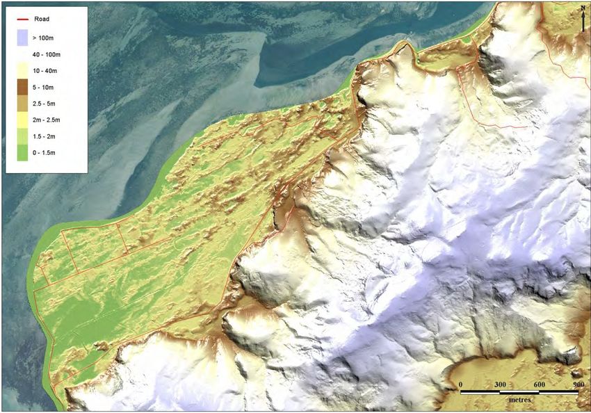
Otago Regional Council
Private Bag 1954, Dunedin 9054
70 Stafford Street, Dunedin 9016
Phone 03 474 0827
Fax 03 479 0015
Freephone 0800 474 082
www.orc.govt.nz

© Copyright for this publication is held by the Otago Regional Council. This publication may
be reproduced in whole or in part, provided the source is fully and clearly acknowledged.

ISBN 978-0-478-37677-7

Report writer:        Michael Goldsmith, Manager Natural Hazards

Published June 2014
Review of Dunedin City District Plan-Natural Hazards: Project Overview                          i

Précis
As part of its current review of its District Plan, the Dunedin City Council (DCC) is reviewing
the way it manages the use of land, so that the effects of natural hazards (including the
effects of climate change) can be avoided, or adequately mitigated. The Otago Regional
Council (ORC) is supporting the DCC by providing natural hazards information, knowledge
and opinion through a collaborative approach, to help inform this review.

A joint DCC/ORC project to identify the characteristics and likely geographical extent of
natural hazards within the Dunedin City boundary commenced in 2013, using the best
information currently available. This report provides a summary of this information, and
identifies areas within Dunedin City where natural hazards may affect public safety, buildings
and the infrastructure which supports communities.

This project is occurring at the same time Otago’s Regional Policy Statement (RPS) is being
reviewed. The RPS sets the framework for future planning, clarifies roles and responsibilities,
and focuses on reducing the current risk associated with natural hazards and avoiding
additional risk. The work described in this report is an example of how the ORC works
together with Otago’s other local authorities (in this case the DCC) to ensure that effects of
natural hazards are avoided, or adequately mitigated.

The effects of events which occur more often (eg, spring tides) tend to be relatively well
understood, while the effects of higher magnitude events which occur less frequently (eg,
major earthquakes) are less well known. Often there is a public perception that the most
recent or well known ‘big event’ is the bench-mark for a particular type of hazard, and that
there is therefore little need to consider the effects of an event larger than previously (or
recently) observed. This project describes the range of effects. This includes events which
can occur fairly regularly (eg, flooding of low-lying riverside settlements), through to credible
high magnitude events which can have the most devastating effects on communities (eg,
major earthquakes and landslides).

More detailed natural hazard information for particular areas is provided in a series of
supplementary technical reports:
1.    Coastal Hazards of the Dunedin City District                              (ORC, 2014a)
2.    Flood Hazard of the Taieri Plain and Strath Taieri                        (ORC, 2014b)
3.    Flood Hazard of Dunedin’s urban streams                                   (ORC, 2014c)
4.    The hazard significance of landslides in and around Dunedin City          (GNS, 2014a)
5.    Assessment of liquefaction hazards in the Dunedin City District           (GNS, 2014b)

These reports include the results of additional investigations undertaken or commissioned by
the ORC, and represent the best information currently available. The additional work includes
an assessment of the significance of landslide hazard, an assessment of liquefaction
susceptibility, and mapping the floodplain areas of the Water of Leith, Lindsay Creek and
Kaikorai Stream catchments.

This report also describes the ‘Principles-based’ approach, which the DCC and ORC have
agreed should be used to manage land-use activities, in order to avoid or mitigate natural
hazards, and to take into account the effects of climate change. These principles are
consistent with the principles informing the review of the natural hazards section of the
ii Review of Dunedin City District Plan-Natural Hazards: Project Overview
Regional Policy Statement and are based around the themes of ‘people and communities’,
and ‘the management of natural hazards’.
In summary, this report, along with a series of supporting documents has been prepared to:
Raise awareness of the characteristics of natural hazard in the Dunedin City District,
and
Help inform the management of land use to avoid or mitigate natural hazards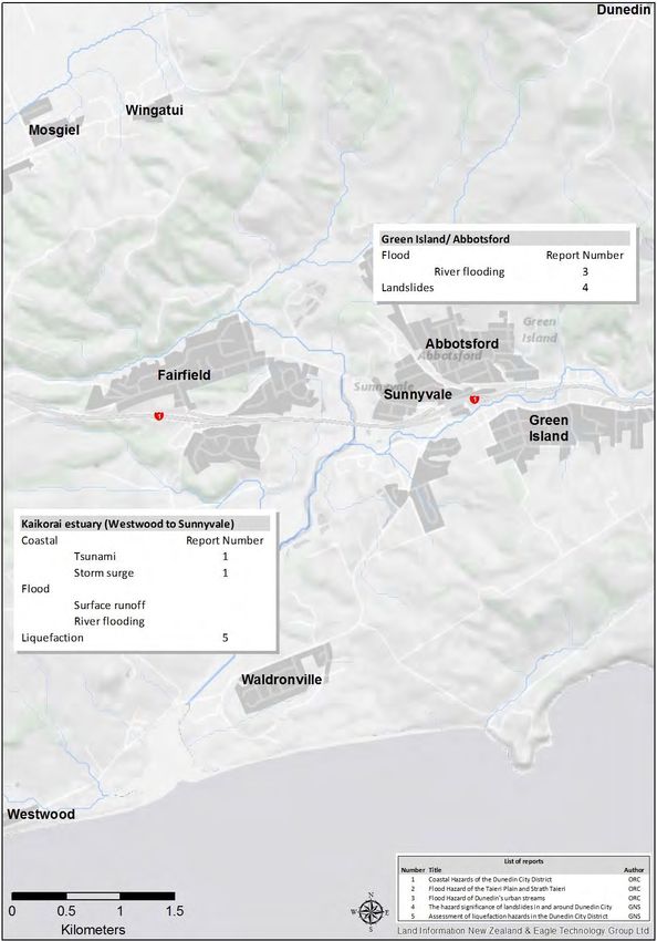
Review of Dunedin City District Plan-Natural Hazards: Project Overview                                                                                  iii

Contents
Précis .................................................................................................................................................. i
1.    Introduction ............................................................................................................................... 1
2.    Environment setting .................................................................................................................. 2
      2.1. Geography ...................................................................................................................... 2
      2.2. Geology .......................................................................................................................... 2
      2.3. Meteorological setting...................................................................................................... 4
      2.4. Hydrological setting ......................................................................................................... 6
      2.5. Community setting........................................................................................................... 6
3.    Legislative context..................................................................................................................... 7
      3.1. Managing natural hazard risk under the current District Plan............................................ 7
      3.2. Managing natural hazard risk under the 2GP ................................................................... 8
      3.3. How this project links with the RPS review....................................................................... 8
4.    Principles and planning considerations .................................................................................... 10
      People and Communities ........................................................................................................ 10
      Management Approach ........................................................................................................... 10
      Planning Considerations ......................................................................................................... 11
5.    Natural hazards in Dunedin City .............................................................................................. 12
      5.1. Types of natural hazards mapped for this project ........................................................... 13
      5.2. Describing the effects of natural hazards ....................................................................... 14
6.    Community-scale overview of natural hazards ......................................................................... 15
Appendix 1. Additional natural hazard information ............................................................................. 29
      Flooding .................................................................................................................................. 29
      Alluvial Fans ........................................................................................................................... 29
      Coastal hazards - Storm Surge and tsunami............................................................................ 29
      Landslides............................................................................................................................... 30
      Seismic Hazard ....................................................................................................................... 30
References ....................................................................................................................................... 31

List of Tables
Table 1            Climatic Regions of Dunedin City (Sourced from Fitzharris, 2010)....................................4
Table 2            Natural hazards described as part of this project............................................................ 13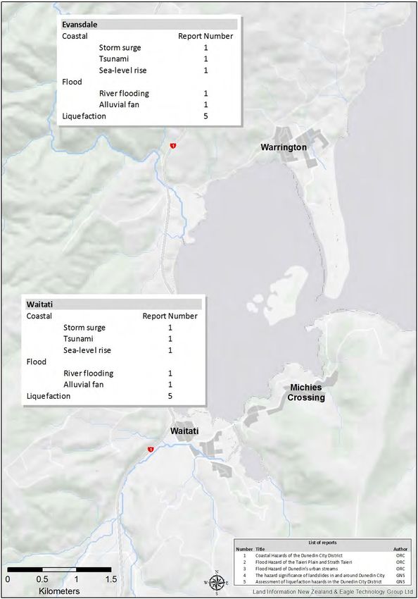
iv                                               Review of Dunedin City District Plan-Natural Hazards: Project Overview

List of Figures
Figure 1    The boundary and main features of the Dunedin City District ........................................... 2
Figure 2    Location of active faults in the Dunedin City District ......................................................... 3
Figure 3    Annual rainfall totals at Musselburgh, 1918 to 2013 ......................................................... 5
Figure 4    LiDAR map showing the topography of the Harwood / Otakou area on Otago
            Peninsula ...................................................................................................................... 12
Figure 5    Overview of the different hazard types affecting Waikouaiti and Karitane ....................... 15
Figure 6    Overview of the different hazard types affecting the coastline between Warrington
            and Puketeraki .............................................................................................................. 16
Figure 7    Overview of the different hazard types affecting Blueskin Bay ........................................ 17
Figure 8    Overview of the different hazard types affecting Purakanui and Long Beach .................. 18
Figure 9    Overview of the different hazard types affecting Aramoana and the northern Otago
            Peninsula ...................................................................................................................... 19
Figure 10   Overview of the different hazard types affecting Port Chalmers and the Otago
            Peninsula ...................................................................................................................... 20
Figure 11   Overview of the different hazard types affecting the upper Otago Harbour and
            Ocean Grove................................................................................................................. 21
Figure 12   Overview of the different hazard types affecting South Dunedin and Dunedin’s
            urban streams ............................................................................................................... 22
Figure 13   Overview of the different hazard types affecting the lower reaches of the Kaikorai
            Stream catchment (Green Island to Westwood) ............................................................. 23
Figure 14   Overview of the different hazard types affecting Brighton, Ocean View and Saddle
            Hill ................................................................................................................................ 24
Figure 15   Overview of the different hazard types affecting North Taieri, Wingatui and Mosgiel....... 25
Figure 16   Overview of the different hazard types affecting Outram, Mill Stream and the West
            Taieri Plain .................................................................................................................... 26
Figure 17   Overview of the different hazard types affecting Henley ................................................. 27
Figure 18   Overview of the different hazard types affecting the Strath Taieri ................................... 28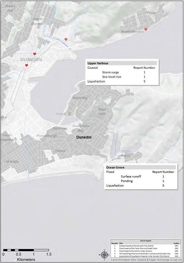
Review of Dunedin City District Plan-Natural Hazards: Project Overview 1
1. Introduction
As part of its current review of its District Plan, the Dunedin City Council (DCC) is reviewing
the way it manages the use of land, so that the effects of natural hazards1 (including the
effects of climate change) can be avoided, or adequately mitigated. The Otago Regional
Council (ORC) is supporting the DCC by collating and presenting existing natural hazards
information to help inform this review.
The review of the District Plan’s approach2 to the management of natural hazards aims to:
Introduce better rules and standards to protect people and property from the risks
posed by natural hazards in these areas;
Provide better information to land owners and investors about constraints on land
development as well as the most suitable land for development; and
Limit the exacerbation of risks from natural hazards.
A joint DCC/ORC project to identify the characteristics and likely geographical extent of
natural hazards within the Dunedin City boundary commenced in 2013, using the best
information currently available. This report provides a summary of this information, and
identifies areas within Dunedin City where natural hazards may affect public safety, buildings
and the infrastructure which supports communities.
This report also describes the ‘Principles-based’ approach, which the DCC and ORC have
agreed should be used to manage land-use activities, in order to avoid or mitigate natural
hazards, and to take into account the effects of climate change. These principles are
consistent with the principles informing the review of the natural hazards section of the Otago
Regional Policy Statement and are based around the themes of ‘people and communities’,
and ‘the management of natural hazards’.
Section 2 describes the physical and social environment of the Dunedin City District, while
Section 3 describes the legislative context within which the review of the District Plan
operates. Section 0 outlines the guiding principles which will help determine the planning
response to be included in the revised District Plan, and Sections 5 and 6 describe and map
(at a district scale) the natural hazards which can affect land within Dunedin City. More
detailed natural hazard information for particular areas is provided in a series of
supplementary technical reports.
This report, along with a series of supporting documents has been prepared to:
Raise awareness of the characteristics of natural hazard in the Dunedin City District,
and
Help inform the management of land use to avoid or mitigate those hazards.
1
A hazard is a source of potential harm or an event with potential to cause loss.
2
More detail about the proposed approach and planned consultation can be found on the DCC’s
website at http://www.dunedin.govt.nz/whats-on/2gp.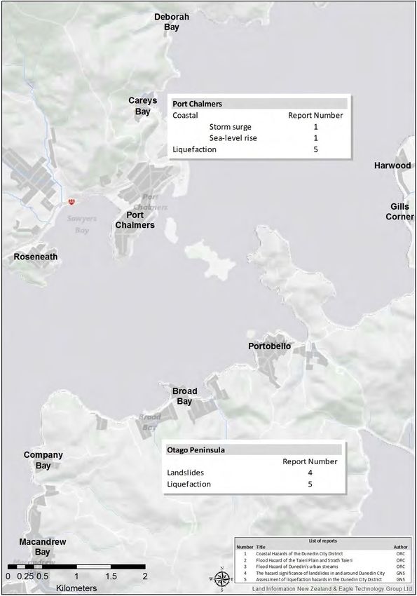
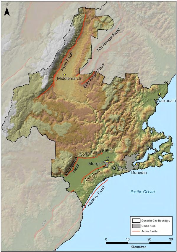
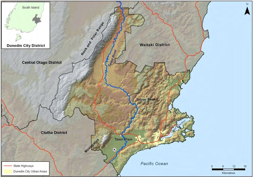
2                                   Review of Dunedin City District Plan-Natural Hazards: Project Overview

2. Environment setting
The natural hazards experienced in Dunedin City are determined by the physical
characteristics of the district, along with the social or ‘built’ environment which may potentially
be affected by a particular event (such as an earthquake or severe storm). These parameters
are summarised briefly below.

2.1.       Geography
The geographical scope of this report is the Dunedin City District, which has a land area of
3,314 square kilometres (Figure 1). The boundary of the district extends to the Rock and
Pillar Range in the west, the Pleasant River in the north, the Pacific Ocean in the east and
south-east, and the Waipori/Taieri River in the south. The coastline extends for
approximately 200km, and includes Otago Harbour.

Figure 1          The boundary and main features of the Dunedin City District

2.2.       Geology
The Dunedin area lies within the Pacific Plate, which is in contact with the Australian Plate
across an active plate boundary (the Alpine Fault) on the west coast of the South Island
(GNS, 1996). Several smaller faults cross the district, including the Akatore Fault which lies
just off the coast, and the Titri and North Taieri faults which straddle the Taieri Plain (Figure
2).
Review of Dunedin City District Plan-Natural Hazards: Project Overview       3

Figure 2            Location of active faults in the Dunedin City District
4 Review of Dunedin City District Plan-Natural Hazards: Project Overview
The area has several distinct landforms:
In the west of the district, and on the margins of the Central Otago District, range-and-
basin type terrain predominates, with flat-topped or rolling block-faulted mountain
ranges, separated by broad alluvial basins.
The Taieri Plain, which lies on the northern part of the Taieri-Tokomairiro depression,
and separates the elevated Central Otago plateaux from the coastal ranges to the east.
A range of coastal hills, stretching from Taieri Mouth on the southern boundary of the
city, to Green Island.
The remains of the Dunedin volcano, including the Otago Harbour, Peninsula, and the
inner city suburbs.
2.3. Meteorological setting
The weather events that impact on Dunedin are major drivers in determining the natural
hazards which affect the city, and combine to create the overall climatic picture. Fitzharris
(2010) identified five distinct climatic regions within the Dunedin City District, determined by
the areas complex topography and other controlling factors. These areas are summarised in
Table 1.
Table 1 Climatic Regions of Dunedin City (Sourced from Fitzharris, 2010)
Climatic Region Climate
North Otago (eg This area has a relatively low annual rainfall, ranging between 500 mm to
Waikouaiti and Karitane) 800 mm. There are generally less than 100 rain days and severe
droughts can occur. Prevailing winds are south-westerly and north-
easterly.
Hills (eg Maungatuas, These areas are cooler, cloudier and wetter than further north. Rainfalls
Flagstaff, Silver Peaks) average 800 mm to 1500 mm annually. South-westerlies predominate,
with occasional very strong north-westerlies gales. Snow may lie for
weeks in winter.
Transitional Central To the west, there is a trend towards a semi-arid, semi-continental
Otago (eg Strath Taieri) climate. Annual rainfall is below 500 mm, with less than 80 rain days.
Drought is common.
Eastern Otago (eg Rainfall is 500 mm to 900 mm and is evenly distributed throughout the
Dunedin urban area, year, but with a slight winter minimum. Winds tend to be from the
Otago Peninsula) southwest, or from the northeast along the coast. The Taieri Plain is a
variant climate of this region in that it is frostier and sunnier. The longest
continuous rainfall record for Dunedin is located within this region, dating
back to 1918 (Figure 3).
Mountain (eg Rock and Climate varies substantially depending on elevation. Annual precipitation
Pillar Range) is at least 1200 mm. Much of winter precipitation falls as snow and may
lie on the ground for many months. Temperatures cool off with elevation.Review of Dunedin City District Plan-Natural Hazards: Project Overview 5
Figure 3 Annual rainfall totals at Musselburgh, 1918 to 2013
Of more importance to weather-related natural hazards (such as flooding and landslide re-
activation) are the characteristics of extreme rainfall events (i.e. storms). Meteorological
conditions which can drive particular climatic hazards include:
Extended periods of moderate to heavy rainfall from the eastern quarter, which can
result in high flows in the coastal catchments such as the Waikouaiti, Water of Leith
and Silver Stream, and the lower reaches of the Taieri River.
A south to southwest airstream, which can also bring moderate to heavy rainfall, strong
winds and occasionally heavy snow. Rainfall events associated with a southerly
change are generally short-lived, although they can result in high flows if catchments
are already saturated from previous rainfall.
Extremely heavy, but short-lived rainfall events can occur over the city in summer.
These rainfall events may temporarily overwhelm storm water networks, causing
localised ponding and can initiate shallow landsliding on susceptible slopes.
Any combination of the above. Rivers and streams rise particularly rapidly when
catchments are already saturated from previous rainfall.
Very heavy rain can be experienced relatively frequently within the Dunedin City District, and
ORC rainfall monitoring sites on the Taieri Plain (Riccarton Road) and in the headwaters of
the Silver Stream and Water of Leith catchments have recorded daily totals in excess of
160mm. A 2013 report by ORC (focusing on the Taieri Plain) found that although there was
some variability in extreme rainfall patterns, some localised areas had experienced a
significant increase in both the intensity and frequency of extreme rainfall events over the
previous 60 years. Average temperature is predicted to increase by another 2°C by 2100.
Given that a warmer atmosphere can hold more moisture, there is potential for storm events
to bring heavier (or more intense) rainfall, and to occur more frequently than has previously
been observed (MfE, 2008).6 Review of Dunedin City District Plan-Natural Hazards: Project Overview
2.4. Hydrological setting
A number of rivers and streams traverse the Dunedin City District. The largest is the Taieri
River which rises in the Lammermoor and Lammerlaw Ranges to the northwest of Dunedin
and meets the Pacific Ocean at Taieri Mouth, 30 km south-west of the Dunedin CBD. The
Taieri River is an important feature for communities in the Strath Taieri and on the Taieri
Plain (ORC, 2013).
The Silver Stream is a tributary of the Taieri River. It originates in the Silver Peaks, emerges
onto the north-eastern corner of the Taieri Plains, and follows a highly modified channel to
join the Taieri River downstream of Mosgiel.
The Water of Leith, Lindsay Creek and Kaikorai Stream all pass through densely populated
areas of the inner city as they convey water from Dunedin’s hill catchments to the coast,
while the Waikouaiti and Waitati Rivers further north are important features of coastal
communities such as Waitati, Waikouaiti and Karitane.
2.5. Community setting
Dunedin’s main urban area spreads around the upper reaches of Otago Harbour and the
surrounding hills. Secondary urban centres include Mosgiel, Port Chalmers, and the
suburban area of Green Island - Fairfield – Waldronville. There are a number of smaller
settlements scattered across the district, including:
The coastal communities of Waikouaiti, Karitane, Warrington and Waitati to the north.
Westwood, Ocean View and Brighton along the coast to the south.
The inland communities of Allanton and Outram on the Taieri Plain, and Middlemarch
on the Strath Taieri.
The city population at the time of the March 2013 census was 120,246, an overall increase of
1.3% from 2006 (Statistics NZ, 2014). The fastest growing areas are Mosgiel, Saddle Hill,
Wingatui and East Taieri, while the population of the inner city suburbs and coastal
communities has generally remained stable.Review of Dunedin City District Plan-Natural Hazards: Project Overview 7
3. Legislative context
The manner and degree to which natural hazards in the Dunedin City District can be
managed by the community, DCC and ORC is influenced by the obligations, powers, and
restrictions set out in various statutes.
The Resource Management Act 1991 (RMA) takes an effects-based approach to resource
management, including the management of any risk associated with natural hazards.
Sections 30 and 31 of the RMA give the ORC and DCC functions to control the use of land
for the avoidance and mitigation of natural hazards. Further, under RMA section 7, in
achieving the purpose of the Act, particular regard shall be had to the effects of climate
change on natural hazards.
The current Otago Regional Policy Statement (RPS)3 specifies that the DCC, through the
Dunedin City District Plan, is responsible for controlling land use to avoid or mitigate the
effects of natural hazards within the district. The District Plan controls what people can do on
their land and how it can be developed. It applies to areas above the line of mean high water
springs (MWHS), and to all users of land and the surface of water bodies in Dunedin.
The RMA requires all operative provisions of a plan to be reviewed every 10 years. The
current Dunedin City District Plan was notified in 1995 and became fully operative on 3 July
2006. While some parts of the District Plan are not due to be reviewed until 2016, there are
large parts of the Plan that have not changed since 1995, and the DCC have decided it is
time to take an holistic look at how to improve the Plan. The aim of the review is to produce a
‘second generation’ District Plan (2GP) (called this because it is the second plan prepared
under the RMA).
The 2GP will be prepared under the RMA in conjunction with the community. It identifies
relevant resource management issues and develops objectives, policies and methods
(including rules) to manage the effects of land use activities on the environment. The ultimate
goal of the District Plan is to manage the natural and physical resources of Dunedin
sustainably to meet the needs of current and future generations, and to provide for their
social, economic and cultural well-being.
3.1. Managing natural hazard risk under the current District Plan
The current District Plan maps do not identify the extent or location of any hazards, instead it
refers to a Hazards Register that sits outside the Plan. The Hazards Register is used by DCC
staff as part of issuing Land Information Memorandums (LIMs) and Project Information
Memorandums (PIMs), which identify whether an activity or structure is proposed on a
hazard prone site.
The District Plan allows the DCC to require resource consent applicants to carry out a site
investigation and assessment of the hazards present on a site for activities which require:
A consent and involve earthworks
A subdivision consent or resource consent where discretion is unrestricted or
An application for building consent
3
Regional Policy Statement for Otago, Otago Regional Council, October 1998. ISBN 0-908922-59-0.8 Review of Dunedin City District Plan-Natural Hazards: Project Overview
Where the site is located on the Hazards Register or the DCC suspects it to be hazard
prone
At present, potentially hazard prone areas area also considered when determining zoning
and developing Plan provisions, particularly scale, location and density of development. In
general ‘Rural’ zoning is currently used as a default zone in potentially hazard-prone areas.
3.2. Managing natural hazard risk under the 2GP
The review of the District Plan’s approach to the management of natural hazards aims to:
Introduce better rules and standards to protect people and property from the risks
posed by hazards in these areas;
Provide better information to land owners and investors about constraints on land
development as well as the most suitable land for development; and
Limit the exacerbation of risks from natural hazards.
To achieve this, the DCC is proposing to use the best available information regarding
Dunedin’s natural hazard risks4 to create the following overlay zones:
Flood Hazard Overlay Zone – includes areas at risk from the effects of flooding
including overland flow, ponding areas and alluvial fans.
Coastal Hazard Overlay Zone – including tsunami, storm surge, erosion and sea-level
rise.
Land Based Hazard Overlay Zone – unstable areas, such as landslides.
This approach was consulted on as an option during the DCC’s 2GP Issues and Options
Consultation Phase from November 2012 to March 2013 and also during the Preferred
Options Consultation Phase in August 2013. More detail about the proposed approach and
this consultation can be found on the DCC’s website at http://www.dunedin.govt.nz/whats-
on/2gp.
A review and overall assessment of natural hazards within the Dunedin City District has been
carried out to help inform the review of the District Plan (see Sections 5 and 6, and the
supplementary technical reports). Based on this assessment, the 2GP preferred option will
be further refined and consulted on again in mid-2014.
3.3. How this project links with the RPS review
The Otago Regional Policy Statement (RPS) became operative on 1 October 1998, and is
currently undergoing review, as required by the RMA. The purpose of the RPS is to achieve
sustainable management of resources by providing;
An overview of the resource management issues of the region, and
Policies and methods to achieve integrated management of the natural and physical
resources of the whole region.
The RPS sets up the framework for future planning and assists in making decisions and
creates opportunities for resource use whilst protecting environmental bottom lines, provides
4
Understanding of natural hazards within the Dunedin context has improved since the current District
Plan was prepared, as has mapping technology.Review of Dunedin City District Plan-Natural Hazards: Project Overview 9
an overview of resource interactions, and gives effect to higher level documents. In general
the high level objectives of the RPS include:
Identify the significant resource management issues for the Region
Promote prosperity (not just in the economic sense)
Ensure a good natural environment
Enable healthy, happy, safe and resilient communities
The review of the RPS, in regards to managing natural hazards, will consider the following
matters:5
Clarification of roles and responsibilities
Enabling more integrated management
Focusing on reducing the current risk associated with natural hazards, and avoiding
additional risk
Protecting people and property
Increasing awareness and understanding of natural hazards
Taking a more holistic approach to natural hazards management (e.g. consideration of
cumulative effects, residual risk)
Regional and district plans must give effect to the RPS. It is therefore important that the ORC
and Territorial Local Authorities (TLA) continue to work together to ensure that the RPS and
regional and district plans work effectively and efficiently together to address Otago’s key
resource management issues. The work described in this report shows this process in action
– with the ORC collating and presenting natural hazards information to help inform the review
of the DCC District Plan, so that the effects of natural hazards can be avoided, or adequately
mitigated.
5
Issues and options papers (based on a range of topics) were drafted in conjunction with TLAs, and a
series of public consultation sessions where held in May 2014. A consultation draft will be prepared for
public consultation in September and the ORC intends notifying the proposed RPS in December 2014.10 Review of Dunedin City District Plan-Natural Hazards: Project Overview
4. Principles and planning considerations
The objectives of the RPS and the proposed approach to natural hazards are reflected in the
approach this project has taken in mapping and describing natural hazards in the Dunedin
City District. The planning response to be included in the revised Dunedin City District Plan
will be based on a series of principles, all of which are consistent with the proposed approach
to natural hazards in the RPS. The principles are based on the Resource Management Act
1991 (RMA) and the functions of local government in relation to natural hazards as outlined
in the RMA.6
The principles also draw from:
Milton 2060. Flood Risk Management Strategy for Milton and the Tokomairiro Plain
(ORC/CDC, 2012)
Sustainable Development Principles (DCC, Long Term Plan 2012/13 – 2021/22,
Adopted 25 June 2012, p35)
Dunedin Towards 2050, A spatial plan for Dunedin / He mahere Wahi ki Otepoti (DCC,
September 2012)
Preparing for climate change (MFE, July 2008, p 16)
Preparing for future flooding (MFE, May 2010, p 28)
New Zealand Standard 9401: 2008 Managing Flood Risk.
The principles are grouped around two main themes: people and communities, and the
management approach for natural hazards.
People and Communities
Principle 1: Protection of people
Prevent death or injury from natural hazards, ensure public health.
Principle 2: Create liveable communities
Create communities in which people can live, work and use the land without undue stress or
fear of natural hazards.
Principle 3: Create a resilient built environment
Create and maintain a built environment, including infrastructure and lifelines, which takes
into account the risks from natural hazards so that it can operate effectively while still being
affordable.
Management Approach
Principle 4: Utilise an adaptive management approach
An adaptive risk management approach will be required to allow for improvements in the
understanding of hazards, and the effects of natural climate variability. The risk associated
6
Note on specific sections and wording of the RMSReview of Dunedin City District Plan-Natural Hazards: Project Overview 11
with different hazards will reduce over time by taking a broad-scale, adaptive approach over
the longer term. The ability to respond to changes in the nature and extent of risk, ease
transitions, and provide the level of safety desired by the community is essential.
Principle 5: Take residual risk into account
It is important to address the entire risk spectrum when managing the effects of natural
hazards. This principle recognises that whatever event is planned for, there will be a larger,
major, event. The risk from these major events also needs to be recognised and managed.
Principle 6: Some risks are intolerable
Principle 7: Avoid exacerbation of natural hazards
New development and hazard management measures will not exacerbate the risks or effects
of natural hazards elsewhere. This applies at all scales, from localised ‘property to property’
effects, through to the community or catchment scale.
Principle 8: Increase understanding and community awareness
Understanding the underlying natural systems and processes that operate in the Dunedin
City District is crucial to managing risk and ensuring community safety. Increasing
community awareness is essential to assist people in taking natural hazard risks into account
when undertaking development.
Planning Considerations
A series of planning considerations have also been developed, which will help to inform
District Plan rules, in regards to avoiding or mitigating the potential effects of natural hazards:
Controls over the way land is used should depend on the characteristics of the hazard
in that area, and its effects on people and assets.
The risk in each community depends on its local geography and exposure to
hazard. Any planning response will depend on the nature of the hazard, and may
include avoidance of new, or restrictions on existing development, or design
standards to avoid or mitigate negative effects.
The consequences of the hazard are critical, along with the likelihood of a particular
event occurring.
The disruption and economic impact at individual and community levels are important
considerations.
The utility and amenity of land will be considered in addition to people’s safety
and damage to buildings.
The cumulative effects of hazard should be considered:
Consider the likelihood of being affected over the longer term.
Consider the likelihood of being affected by any of the hazards which may affect
a particular area.
Consider the cumulative effects of repeat events.12 Review of Dunedin City District Plan-Natural Hazards: Project Overview
5. Natural Hazards in Dunedin City
A diverse range of information is available which can be used to describe natural hazards in
the Dunedin City District. Observations and historical records cover the period from pre-
European settlement to modern times, and include photographs, written records and early
maps and sketches. In more recent times, technology has meant that a range of hazard
scenarios have been able to be modelled. This includes the effects of ‘extreme’ events which
occur infrequently (including events which are possible, but have not been observed often, or
at all during our relatively short recorded history), and more commonly occurring events. The
effects of predicted changes in climate and sea level (Fitzharris, 2010) are increasingly being
integrated into these modeled scenarios.
Both types of information (observations and modelling) can be used to map certain areas
which are prone to natural hazards. Another tool which helps to inform the way natural
hazards are mapped is accurate topographical information (LiDAR7) which is now available
for most of the settled part of the district. An example is shown in Figure 4.
Figure 4 LiDAR map showing the topography of the Harwood / Otakou area on Otago
Peninsula
In 2012, the ORC launched a web-based Natural Hazards Database, which contains
information on natural hazards across Otago. It is intended to improve the availability of
hazard information and to help the public, local authorities, and others make informed
7
LiDAR: Light Detection and Ranging is a mass of spot-height information captured over a wide area
using an aircraft mounted laser. LiDAR data is held by the DCC and ORC, and typically has a vertical
accuracy of +/- 0.14m.Review of Dunedin City District Plan-Natural Hazards: Project Overview 13
decisions about their exposure to natural hazards. It contains both modelled and observed
information, and includes much of the information used to inform this project. It is available
through the ORC website (www.orc.govt.nz).
5.1. Types of natural hazards mapped for this project
This project identifies the characteristics and likely geographical extent of the natural hazards
listed in Table 2, using the best information currently available. The information has been
collated and presented in a way to help inform the review of the Dunedin City District Plan.
As described above, the DCC is proposing to use this information to create three hazard
‘overlays’ or zones - Flood, Coastal, and Land – and these are also shown in Table 2.
Table 2 Natural hazards described as part of this project
Hazard Sub-category
Flood Floodwater resulting from high flows in rivers and other waterways
(DCC Flood Hazard Overland flow paths which drain surface runoff during heavy rainfall
Overlay Zone) events
Water ponding in low-lying areas which are natural collection points for
floodwater and surface runoff
Alluvial fans, ranging from sheet floods and channel floods carrying
sediment through to debris dominant flows.
Coastal Inundation due to elevated sea level (storm surge)
(DCC Coastal Hazard Inundation due to tsunami
Overlay Zone)
Coastal erosion
The likely effect of additional sea-level rise on coastal hazards
Landslides Landslide features which have moved in the past
(DCC Land Based
Hazard Overlay Zone)
Seismic Susceptibility to lateral spreading and liquefaction
(DCC Land Based Known active faults
Hazard Overlay Zone)
Seismic shaking
Additional information describing the hazards in Table 2 is provided in Appendix 1, including
a description of how the effects of climate change and sea-level rise have been incorporated
into this project.
There are other natural hazards in the Dunedin City District, for which information is held,
such as drought, snow and other climatic hazards. These hazards are not addressed
specifically in this project as their extent and characteristics cannot be defined with the same
level of precision as those listed in Table 2. Direction to ensure these hazards are mitigated
or managed is often contained outside of the District Plan (eg, New Zealand Standard 3604:
2011; Building Act, 2004). In addition, information relating to flooding associated with the
failure or limited capacity of stormwater networks is not included in the reports prepared by14 Review of Dunedin City District Plan-Natural Hazards: Project Overview
ORC. Information on the likelihood and effects of stormwater flooding is reported separately
by DCC (2011).
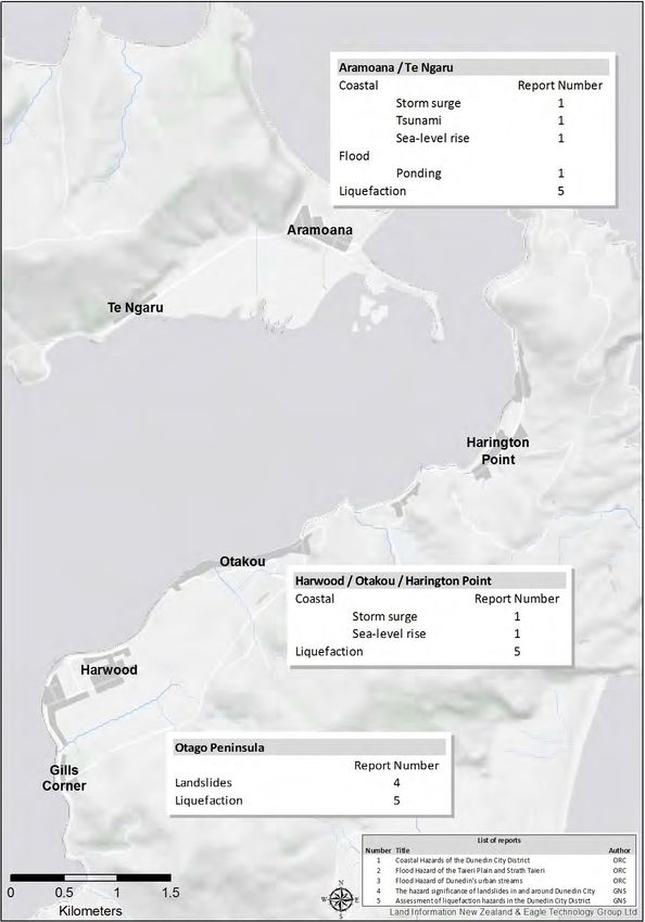
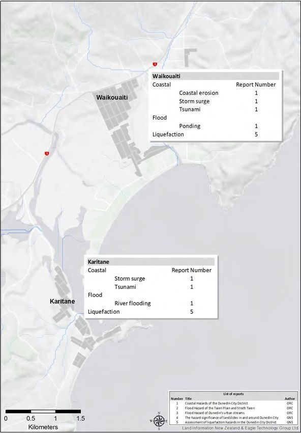
5.2. Describing the effects of natural hazards
This project describes the characteristics and effects of natural hazards in the Dunedin City
District, focusing on areas of existing development, future development potential, and also
where the effects of the hazard are significant. Rather than simply describe the effects of
each hazard separately, this project considers the cumulative and long-term effects of single
or multiple hazards on a community. The maps below provide an overview of the different
hazard types listed in Table 2, at the scale of individual communities within the district
(Figure 5 to Figure 18). More detailed information, describing and mapping the hazards
which affect particular communities is provided in a series of supplementary technical
reports:
1. Coastal Hazards of the Dunedin City District (ORC, 2014a)
2. Flood Hazard of the Taieri Plain and Strath Taieri (ORC, 2014b)
3. Flood Hazard of Dunedin’s urban streams (ORC, 2014c)
4. The hazard significance of landslides in and around Dunedin City (GNS, 2014a)
5. Assessment of liquefaction hazards in the Dunedin City District (GNS, 2014b)
These five reports illustrate the cumulative effects of natural hazards on particular areas, by
helping to understand:
The likelihood of an area being affected by any hazard. For example, land which is
susceptible to flooding may also be prone to liquefaction and lateral spread.
The likelihood of an area being affected over the longer term. For example, the chance
of a coastal community being affected by a high magnitude tsunami event in any given
year may be relatively small, but the likelihood of such an event occurring at least once
during the time a person may live in such an area (10 – 50+ years) is much higher.
The cumulative effects of repetitive events on people and assets. An example is where
a series of flood events occur over a short space of time, affecting a particular
community or area several times in quick succession.
The adverse effects of one hazard being compounded by another hazard occurring at
the same time. For example, a coastal community at the mouth of a river, where the
effects of flooding may be exacerbated by elevated sea levels.
The supplementary technical reports identify and map areas which have a similar
vulnerability to natural hazards. The description of the ‘hazardscape’ of each community has
been informed by a range of information, including previous investigations of natural hazards
(eg, ORC 2013 Natural Hazards of the Taieri Plains, and NIWA 2007 Tsunami modelling
study), observations and local knowledge, historical mapping, and national guidance on
climate change and sea-level rise (eg, Bell 2013, MfE 2008a, 2008b). Where possible,
natural hazards have been described in terms of their effect on people and assets – i.e. how
they may affect public safety, buildings and other assets.Review of Dunedin City District Plan-Natural Hazards: Project Overview 15 6. Community-scale overview of natural hazards Figure 5 Overview of the different hazard types affecting Waikouaiti and Karitane
16                        Review of Dunedin City District Plan-Natural Hazards: Project Overview

Figure 6   Overview of the different hazard types affecting the coastline between
           Warrington and Puketeraki
Review of Dunedin City District Plan-Natural Hazards: Project Overview 17 Figure 7 Overview of the different hazard types affecting Blueskin Bay
18                         Review of Dunedin City District Plan-Natural Hazards: Project Overview

Figure 8   Overview of the different hazard types affecting Purakanui and Long Beach
Review of Dunedin City District Plan-Natural Hazards: Project Overview                      19

Figure 9            Overview of the different hazard types affecting Aramoana and the northern
                    Otago Peninsula
20 Review of Dunedin City District Plan-Natural Hazards: Project Overview
Figure 10 Overview of the different hazard types affecting Port Chalmers and the Otago
PeninsulaReview of Dunedin City District Plan-Natural Hazards: Project Overview 21
Figure 11 Overview of the different hazard types affecting the upper Otago Harbour and
Ocean Grove22 Review of Dunedin City District Plan-Natural Hazards: Project Overview
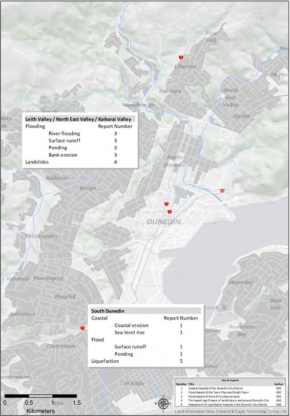
Figure 12 Overview of the different hazard types affecting South Dunedin and
Dunedin’s urban streamsReview of Dunedin City District Plan-Natural Hazards: Project Overview 23
Figure 13 Overview of the different hazard types affecting the lower reaches of the
Kaikorai Stream catchment (Green Island to Westwood)24 Review of Dunedin City District Plan-Natural Hazards: Project Overview
Figure 14 Overview of the different hazard types affecting Brighton, Ocean View and
Saddle HillReview of Dunedin City District Plan-Natural Hazards: Project Overview 25
Figure 15 Overview of the different hazard types affecting North Taieri, Wingatui and
Mosgiel26 Review of Dunedin City District Plan-Natural Hazards: Project Overview
Figure 16 Overview of the different hazard types affecting Outram, Mill Stream and the
West Taieri PlainReview of Dunedin City District Plan-Natural Hazards: Project Overview 27 Figure 17 Overview of the different hazard types affecting Henley
28                           Review of Dunedin City District Plan-Natural Hazards: Project Overview

Figure 18   Overview of the different hazard types affecting the Strath Taieri
Review of Dunedin City District Plan-Natural Hazards: Project Overview                       29

Appendix 1. Additional natural hazard information
Flooding
The flood areas mapped for this project show land which is at risk of inundation due to flood
events in rivers and estuaries, as well as surface ponding and ephemeral features such as
overland flows paths and alluvial fans (see below). It does not include flooding due to
overloading of the urban stormwater network. In addition, flood extents are only shown for
areas where this hazard has been documented and investigated – mapped flood areas do
not cover sections of some rivers and estuaries where the ORC do not hold sufficient
information to accurately assess flood hazard.

The effects of flooding (and other climatic hazards) may be exacerbated in the future by
changes in climate, with heavier and/or more frequent extreme rainfalls expected over New
Zealand (MfE, 2008). Where possible, the effects of climate change have been considered
when mapping flood areas. This has been done by incorporating knowledge about high
magnitude historical events for which there is limited information available, and by identifying
areas on the margins of mapped flood areas, which could be affected by events larger than
those observed in recent times.

Alluvial Fans
An alluvial fan is an accumulation of river or stream (alluvial) sediments which form a sloping
landform, shaped like an open fan or a segment of a cone. They typically occur near the
boundary between hillslopes and valleys. They owe their origins to changes in the slope of
natural drainage systems, for example where a steep gully merges onto a flatter valley floor.

The alluvial fans identified in the Dunedin District vary in size, age and level of activity and
many of the fans only become active during high rainfall events. Mapped alluvial fans are
derived from work undertaken by Opus (2009) at a regional, 1:50,000 scale. Additional work
has been undertaken to determine the significance of alluvial fans on the east Taieri (GNS,
2014c).

Coastal hazards - Storm Surge and tsunami
NIWA (2007 and 2008) mapped the height and likely extent of water associated with a limited
range of credible storm surge and tsunami scenarios. This work assumed no erosion of the
coastline, and did not include the potential effects of debris, vegetation or structures. The
effect of sea-level rise of up to 0.5m was included in this work.

This information has been used to identify communities which are vulnerable to coastal
hazards, and to help create mapped coastal hazard areas in the report ‘Coastal Hazards of
the Dunedin City District’. The latest recommendations on likely rates of sea-level rise over
the coming century were also used to help assess coastal hazards. A more recent
assessment of all sources of tsunami that could potentially affect the New Zealand coast is
also referred to in this report (GNS, 2013).
30                                 Review of Dunedin City District Plan-Natural Hazards: Project Overview

Landslides
The term "landslide" describes a variety of processes that result in the downward and
outward movement of slope-forming materials including rock, soil, artificial fill, or a
combination of these. The materials may move by falling, toppling, sliding, spreading, or
flowing. Landslides can vary in size from a single boulder in a rock fall to tens of millions of
cubic metres of material in a debris avalanche.

Landslides (along with other landscape-forming processes) have helped to shape the
Dunedin area over many thousands of years. The landslides shown on this map include
areas which have moved relatively recently, and locations where distinct landforms have
been used to map historical landslide features. The likelihood of further movement and the
significance of any hazard which may be associated with that movement have also been
investigated as part of this project (GNS, 2014a).

Only known landslides are shown. Areas that may be prone to landslides (due to slope,
substrate or other characteristics of the land) are not shown. Some areas within the Dunedin
City District have not been investigated with respect to landslides.

Seismic Hazard
Liquefaction occurs when saturated fine grained sediments (such as sand and silt) are
subjected to high intensity shaking and lose their ability to stay cohesive. As sediments are
shaken, they act like a fluid or shaken jelly, causing deformation, settlement, and sometimes
lateral spread towards rivers or lakes. Areas with unconsolidated sediments, soils, and high
groundwater tables have a high risk exposure to liquefaction and lateral spreading of soils.
Locations close to active faults have a higher risk exposure to liquefaction due to more
intense ground shaking. These characteristics were used to identify the susceptibility of land
to liquefaction and lateral spread during an earthquake. Additional work by GNS (2014b) was
undertaken to help this assessment.
Review of Dunedin City District Plan-Natural Hazards: Project Overview                     31

References
Bell, 2013. A submission on the proposed Northland Regional Policy Statement. Evidence of
Dr. Robert Gordon Bell for Director-General of Conservation.

Building Act, 2004.

Dunedin City Council, 2011. Integrated Catchment Management Plan documents. Accessed
online at http://www.dunedin.govt.nz/your-council/council-projects/3waters/icmpdocuments

Fitzharris, B. 2010. Climate change impacts on Dunedin. Climate Management Ltd.
Unpublished report for Dunedin City Council. March 2010.

GNS Science, 2014a. The hazard significance of landslides in and around Dunedin City.
Report prepared for the Otago Regional Council.

GNS Science, 2014b. Assessment of liquefaction hazards in the Dunedin City District.
Report prepared for the Otago Regional Council.

GNS Science, 2014c. Extent and characteristics of alluvial fans in the north-eastern sector of
the Taieri Plain, Otago. Report prepared for the Otago Regional Council.

GNS Science, 2013. Review of tsunami hazard in New Zealand.

GNS Science, 1996. Geology of the Dunedin Area.

Otago Regional Council, 2014a. Coastal Hazards of the Dunedin City District.

Otago Regional Council, 2014b. Flood Hazard of the Taieri Plain and Strath Taieri.

Otago Regional Council, 2014c. Flood Hazard of Dunedin’s urban streams.

Otago Regional Council, 2014d. Natural Hazards and the Dunedin City District Plan. Report
to ORC Policy Committee, 2014/0765.

Otago Regional Council, 2013. Natural Hazards of the Taieri Plains, Otago.

Ministry for the Environment, 2008. Climate Change effects and impacts assessment, A
Guidance Manual for Local Government

NZS 3604: 2011. Timber-framed buildings

NIWA, 2008. Client Report CHC 2008-047. Otago Regional Council Storm Surge Modelling
Study.

NIWA, 2007. Client Report CHC 2007-030. Otago region hazards management investigation:
tsunami modelling study.

Statistics NZ, 2014. Stats Maps. Accessed online during March 2014 at:
http://www.stats.govt.nz/StatsMaps/Home/Maps/2013-census-population-dwelling-map.aspx.
32                              Review of Dunedin City District Plan-Natural Hazards: Project Overview

Ministry for the Environment, 2008a. Coastal Hazards and Climate Change. A Guidance
Manual for Local Government in New Zealand. 2 nd edition. Revised by Ramsay, D, and Bell
R. (NIWA). Prepared for Ministry for the Environment.

Ministry for the Environment, 2008b. Preparing for climate change. A guide for local
government in New Zealand.
You can also read