Country Fiche Germany - VASAB
←
→
Page content transcription
If your browser does not render page correctly, please read the page content below
Country Fiche
  Germany

     Updated April 2021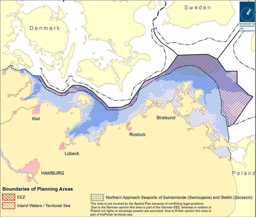
1. General information

Map: German Baltic Sea EEZ and Territorial Sea / Inland Waters
Source: Federal Maritime and Hydrographic Agency (BSH)

Exclusive Economic Zone in the Baltic Sea: 4.500 km2
Inland Waters and Territorial Sea in the Baltic Sea: 10.900 km2

    1.1. Governance
The Federal Ministry of the Interior, Building and Community (BMI) is responsible for drawing up
maritime spatial plans for the German Exclusive Economic Zone (EEZ) in the North and Baltic Sea.
These plans are setting targets (legally binding) and principles (guidelines that need to be
particularly considered, e.g. in a decision process on licensing, when taking into account relevant
interests) of spatial planning with regard to
    -   economic and scientific use,
    -   ensuring safety and efficiency of maritime traffic
    -   protection of the marine environment.
This task is carried out within the framework of UNCLOS and other relevant international and
European legislation.

                                                        2
Federal Coastal States are responsible for setting up spatial targets and principles for their
respective share of internal waters and territorial sea in the North and Baltic Sea.
   • In Schleswig-Holstein the competent authority is the Ministry of the Interior, Rural Areas
       and Integration Schleswig-Holstein.
   • In Mecklenburg-Vorpommern the responsibility lies with the Spatial Planning Authority in
       the Ministry of Energy, Infrastructure and Digitalisation.

   1.2. Contacts
       1.2.1 EEZ

MSP in general:             Federal Ministry of the Interior, Building and Community
                            www.bmi.bund.de

                            Federal Maritime and Hydrographic Agency (BSH)
                            www.bsh.de
                            Mr Kai Trümpler
                            Head of Unit Spatial Planning
                            +494031906100
                            kai.truempler@bsh.de

MSP Data Focal point        Federal Maritime and Hydrographic Agency (BSH)
                            www.bsh.de

Environmental concerns:     Federal Ministry for the Environment, Nature Conservation and
                            Nuclear Safety
                            (Espoo contact point)
                            www.bmu.bund.de

                            German Federal Agency for Nature Conservation (BfN)
                            www.bfn.de

                            German Environment Agency (UBA)
                            www.umweltbundesamt.de

       1.2.2 Internal Waters and Territorial Sea

Schleswig-Holstein

MSP in general:             Ministry of the Interior, Rural Areas, Integration and Equality of the State
                            Schleswig-Holstein
                            www.schleswig-holstein.de
                            Mr Frank Liebrenz
                            +494319881734
                            frank.liebrenz@im.landsh.de
Mecklenburg-Vorpommern

                                                 3
MSP in general:               Ministry of Energy, Infrastructure and Digitalisation Mecklenburg-
                              Vorpommern
                              www.em.mv-regierung.de
                              Ms Petra Schmidt-Kaden
                              +493855888350
                              petra.schmidt-kaden@em.mv-regierung.de

MSP Data Focal point          same as general MSP contact

2. General information on legislation
International / EU legislation and frameworks have to be considered in MSP, e.g.
    • UNCLOS
    • IMO regulations and resolutions
    • MARPOL
    • MSP Directive 2014/89/EU (adopted in July 2014)
    • SEA Directive 2001/42/EC
    • Habitats Directive 92/43/EEC
    • MSFD 2008/56/EC
    • Baltic Sea Action Plan
    • HELCOM Convention
    • VASAB Long Term Perspective
    • all relevant EU communications.

National legal basis for MSP is the Spatial Planning Act („Raumordnungsgesetz“ / ROG), which was
made applicable for the EEZ in 2004. A revised version came into force as of 29th November 2017.
It takes into account the MSP Directive’s requirements for transboundary consultation and
coordination in MSP, land-sea interactions and application of the ecosystem approach.

The public as well as public authorities, whose interests are affected, must
   -   be informed about the process,
   -   be consulted
   -   have the opportunity to comment on the draft plan,
prior to drafting a final version of the plan, followed by approval by all affected ministries and the
government and finally put into effect.
When setting up a maritime spatial plan an SEA must be carried out. Expected significant effects
on the environment have to be named and evaluated in an environmental report; results of the
SEA and comments from the participation process have to be taken into account when balancing
various interests (see Spatial Planning Act (ROG) and Environmental Impact Assessment Act
(UVPG)) to come up with a final set of rules and regulations.

                                                  4
3. General applicability (e.g. territorial Sea, EEZ, other distinctions)

According to the German Spatial Planning Act the Federal Government is responsible for maritime
spatial planning in the German EEZ. The territorial sea is part of the spatial plans of the coastal
federal states which cover both terrestrial areas and marine waters. Legal bases are the German
Spatial Planning Act and respective (coastal) federal states spatial planning laws.

4. Spatial Plans

   4.1. Maritime Spatial Plans for the EEZ of the Baltic Sea

       4.1.1. Legal basis
The general Spatial Planning Act („Raumordnungsgesetz“ / ROG) was made applicable to the EEZ
in 2004. At present the Federal Ministry of the Interior, Building and Community (BMI) is
responsible for setting up Maritime Spatial Plans in the German Exclusive Economic Zone (EEZ) - in
the framework of UNCLOS.

Relevant national legislation:
    • Federal Maritime Responsibilities Act (SeeAufG), as of 26 July 2002, plus related
      regulations, incl. Marine Facilities Ordinance (SeeAnlV)
    • Federal Mining Act (BBergG) as of 13 August 1980 (last updated July 20th, 2017)
    • Renewable Energy Sources Act or RES (EEG), 2017 version
    • Offshore Wind Energy Act (Windenergie-auf-See-Gesetz – WindSeeG) as of 13 Oct. 2016,
      entry into force Jan. 1st, 2017
    • Energy Industry Act (EnWG) of 7 July 2005 (and Grid Expansion Acceleration Act (NABEG)
      of 28 July 2011
    • Federal Nature Conservation Act (BNatSchG) as of 2010 (last updated 12 December 2019)
    • Federal Water Act (WHG) as of 31.07.2009, (last update 11 June 2019)
    • Act on the Assessment of Environmental Impacts (UVPG) 1990 (last updated 13.05.2019, in
      force as of 18.12.2019)

Spatial Planning Legislation in general names requirements, tasks and guidelines of spatial
planning, aiming to achieve a balanced structure of settlements and open landscapes as well as
the ecosystem, avoid uncontrolled development and maintain efficient infrastructure. For the EEZ
the maritime spatial plan shall include targets (legally binding) and principles (guidelines that need
to be particularly considered in the decision process) of spatial planning with regard to a) economic
and scientific use, b) ensuring safety and efficiency of maritime traffic, and c) protection of the
marine environment. Respective areas for these uses and functions may be stipulated.

       4.1.2. Legal impact
The plan sets binding rules and regulations for authorities, mainly with regard to licensing
procedures and approval of investments and activities.

                                                  5
4.1.3. Area covered
The planning area covers the German EEZ in the Baltic Sea, though does not include the charted
area showing the northern approaches to the ports of Świnoujście and Szczecin and anchorage no.
3 because of contradictory legal opinions. According to German opinion this area is part of the
German EEZ, whereas in relation to Poland no rights or sovereign powers are exercised. According
to Polish opinion this area is part of the Polish territorial sea.

(A) Maritime Spatial Plans for the German North and Baltic Sea EEZ 2009

        4.1.4. Historic development
The planning process for the first Maritime Spatial Plans for the German EEZ in the North and Baltic
Sea started in 2005 with a questionnaire sent out to agencies and NGOs to obtain an overview on
activities, licences and interests in the EEZ. A “scoping meeting” took place in 2005 with agencies
and NGOs to discuss the scope of the necessary Strategic Environmental Impact Assessment. The
Federal Ministry of Transport, Building and Housing BMVBW, (later BMVBS, since December 2013:
BMVI1) and BSH drafted maritime spatial plans which in conjunction with the SEA report was given
into public participation in 2008; transboundary consultation was conducted and public hearings
were held. In December 2009 the final version of the Maritime Spatial Plan for the German EEZ in
the Baltic Sea was enacted by the Ministry of Transport. The MSP for the North Sea EEZ was set
into force in September 2009.

        4.1.5. Objectives of the plan
Starting point for Maritime Spatial Planning in Germany is the guiding principle of sustainable
spatial development, which brings social and economic demands regarding space in line with the
sea’s ecological functions, and shall lead to a permanent, large scale balanced order. An integrative
and sustainable approach is needed for the development of the German Exclusive Economic Zone
(EEZ), addressing growing conflicts of maritime uses, such as developing space consuming offshore
wind farms and marine environmental protection goals, but as well traditional maritime uses such
as shipping and fisheries.

5 guidelines:
    1. Safeguarding and strengthening maritime traffic;
    2. Strengthening economic capacity through orderly spatial development and optimisation
         of spatial use;
    3. Promotion of offshore wind energy use in accordance with the Federal Government’s
         sustainability strategy;
    4. Long-term sustainable use of the features and potentials of the EEZ through reversible
         uses, efficient use of space, and priority of marine-specific uses;
    5. Safeguarding natural environment by avoiding disruptions to and pollution of the marine
         environment.

1
 Responsible for MSP in the German EEZ from March 2018: Ministry of the Interior, Building and Community
(BMI)
                                                      6
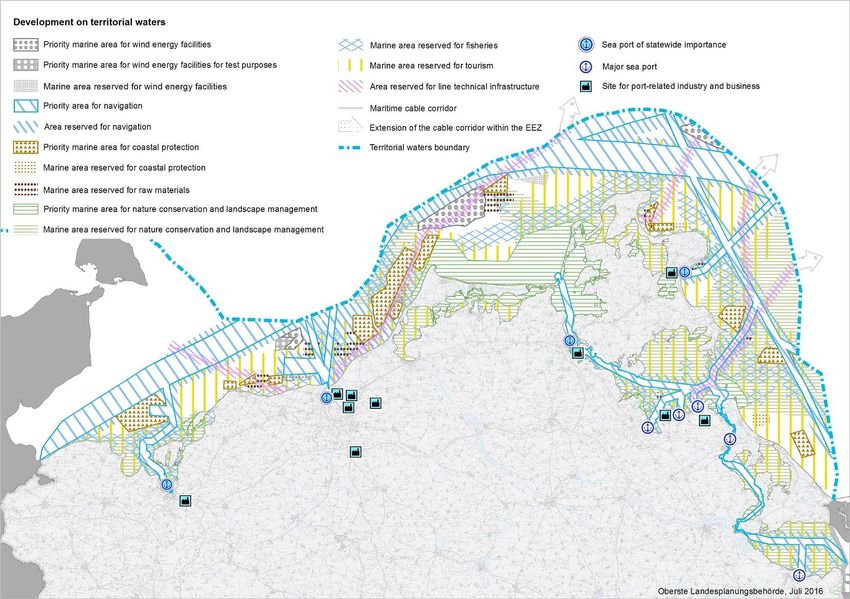
4.1.6. Map

Scale: 1:400.000

        4.1.7. Designations
The basic spatial plan structure builds on the analysis of ship traffic based on AIS-information
provided by the Water- and Shipping Administration. With shipping having special weight
according to UNCLOS, main shipping routes are designated priority areas, which must be kept free
from obstacles (e.g. wind farms). This designation follows Art. 60 para. 7 UNCLOS which rules that
installations may not be established by the coastal State where they are capable of interfering with
the use of recognised sea lanes essential to international navigation. The second important
regulation is the designation of priority areas for offshore wind energy, to avoid and reduce
significant conflicts with other uses and the marine environment. Thirdly protection of the marine
environment is being addressed in the spatial plan e.g. by installation of wind turbines not being
allowed within Natura 2000 areas. However, in the spatial plans nature conservation areas under
the Habitats and Birds Directive are depicted for information only.

Designation categories:

Spatial designations have been made by determining priority areas (planning targets, legally
binding) and reservation areas (planning principles) – further textual regulations are setting more
binding planning priorities, planning principles, rules and objectives to be followed.

                                                 7
Planned Sea-uses:
Shipping:
In the priority areas for shipping this activity is granted priority over other spatially significant uses
and no permission is given to planning, measures and projects not compatible with the shipping
priority. In reservation areas for shipping specific consideration is given to shipping interests – a
comparative evaluation with other spatially significant planning tasks, measures and projects has
to be conducted.

                                                                                 Shipping
                                                                                       Reservation Area
                                                                                       Priority Area

                                                                                  15   Numbering of Shipping Routes

Priority and Reservation Routes for Shipping
Source: Federal Maritime and Hydrographic Agency (BSH)

Pipelines:
Specific consideration is to be given to laying, operating and maintenance of pipelines in
reservation areas for (in 2009 existing) pipelines in the Baltic Sea in relation to other activities.

Marine scientific research:
Specific consideration is to be given to scientific research activities within reservation areas for
research in relation to other activities.

Energy production, wind energy in particular:
Production of wind energy is granted priority over other spatially significant uses in the priority
areas for wind energy. Offshore wind turbines outside designated priority areas are not allowed
within Natura 2000 areas.

                                                         8
4.1.8. Regulations
The Maritime Spatial Plans for the EEZ determine co-ordinated regulations for single uses and
functions:
• shipping,
• pipelines and submarine cables,
• marine scientific research,
• energy production (especially wind energy),
including regulations determining areas for single uses and functions. Further activities in the EEZ
such as military excercises, will find co-ordinated consideration within the regulations mentioned
above. Management arrangements are being introduced at a later stage, for instance at project
level dealing with applications for specific activities (e.g. wind farms, cables). In the spatial plans
nature conservation areas under the Habitats and Birds Directive are depicted for information
only. For these areas – which are also designated as marine protected areas since Septenber 2017
- management plans are to be developed by the competent Agency for Nature Conservation.
4.1.9. Adoption
German parliament adopted and the Federal Ministry of Transport, Building and Urban Affairs,
enacted the maritime spatial plan for the EEZ of the Baltic Sea as “Ordinance on Spatial Planning
in the German Exclusive Economic Zone in the Baltic Sea (AWZ Baltic Sea-ROV)” on 10th December
2009, the plan entering into force on Dec. 19th 2009.
4.1.10. SEA
As a basis for description and assessment of any substantial impacts on the marine environment
that are likely to be caused by the implementation of the plan, a large scale Strategic Environment
Assessment (SEA) has been carried out – for the first time in a sea area distant from the coast. The
SEA predicted no significant effect on the marine environment evoked from the implementation
of the plan.
4.1.11. Public participation
Broad public participation was secured through consultation with stakeholders (mostly agencies
and NGOs): marine environment and nature conservation, fisheries, energy, sand and gravel,
shipping, military, tourism, leisure boating, research.
A public hearing on the draft plan with ca. 80 stakeholders attending - mainly from other planning
authorities, industry and NGOs – was held in Rostock in late 2008.
4.1.12. Transboundary consultation
Consultations with neighbouring countries were conducted by
• notifying about the intention to set up a maritime spatial plan in the initial phase of the
planning process and asking about their interest in being kept informed and consulted
• consultation on the draft maritime spatial plan by written information
• several face-to-face meetings with neighbouring countries’ representatives
9• ESPOO consultation in the course of the Strategic Environmental Assessment, asking for
potential negative impact of the plan on neighbouring countries’ marine environment, on
protected areas in particular.
4.1.13. Harmonisation with other plans
An area which adjoins the German Baltic Sea EEZ, already featuring spatial planning provisions for
marine space, was the German territorial sea administered by the federal state of Mecklenburg-
Vorpommern. The Spatial Development Program had been enacted in 2005. This plan followed
different planning objectives which were distinctly driven by coastal development - with spatial
designations e.g. for nature protection, sand and gravel extraction and tourism, and suitable areas
for offshore wind energy which do not allow for any further offshore wind energy development
outside of these areas. Shipping was not regulated, the map only depicting some major shipping
routes. Thus MSP for the EEZ did not take this plan as a model, and chose another approach, with
starting out to secure safe and easy shipping and regulating infrastructure development.
4.1.14. Monitoring
In 2012 an evaluation report was prepared by BSH and the Ministry of Transport, which assessed
if and how the implementation of the plan had been successful in reaching its objectives, focusing
mainly on the development of offshore wind energy and the targets set for offshore wind energy
production by the Federal government. Steering effects were obvious, offshore windfarm
applications now being limited to the priority areas for offshore wind energy and areas with no
general limitation to offshore wind farm development. Thus adequate space had been secured for
medium to long-term development of the sector, as a prerequisite for implementation of the
government’s renewable energy strategy.
But the need for better steering mechanisms and spatial provisions for cable connections resulted
in the introduction of Spatial Offshore Grid Plans, and – in the wake of a system change, for
promoting and developing offshore wind energy production - the Site Development Plan,
introduced by the 2017 version of the Renewable Energy Sources Act and the new Wind Energy
Act (see Chapter 6).
Comprehensive monitoring of the effects and evaluation of the plan’s content, development and
implementation process is now being conducted as initial step towards revision and updating of
the EEZ plans.
4.1.15. Electronic resources
MSP Documents:
MSP for the German EEZ in the North Sea, MSP for the German EEZ in the Baltic Sea:
• Legal Ordinance (English translation),
• Maritime spatial plan with justification (English translation),
• map (English version) and
• English summary of environmental report.
https://www.bsh.de/EN/TOPICS/Offshore/Maritime_spatial_planning/National_spatial_planning/
national_spatial_planning_node.html
10MSP Data:
MSP Data (spatial designations only) will be accessable via Geoseaportal (WMS, WFS)
www.geoseaportal.de), respective services are under development. Coordinates of designated
areas are listed in an annex to the above mentioned MSP document.
https://www.bsh.de/EN/TOPICS/Offshore/Maritime_spatial_planning/National_spatial_planning
/_Anlagen/Downloads/Raumordnungsplan_Textteil_Ostsee.html?nn=2043950
The Baltic Sea MSP data is also accessable via the BASEMAPS web portal,
https://basemaps.helcom.fi, MSP output data – providing information on German MSPs (EEZ,
Mecklenburg-Vorpommern, layer “Plan Area”) and spatial plan designations (“View” or “Query”
Planned Sea Uses).
BASEMAPS
(B) Revision Process - Maritime Spatial Plans for the German North and Baltic Sea EEZ 2021
4.1.16 Planning Process
• Revision of the MSPs for the EEZ of the Baltic Sea and the North Sea had been initiated in
2018/2019, following involvement in Interreg and DG Mare projects on MSP from 2009 until
today (BaltSeaPlan, PartiSEApate, Baltic LINes,Baltic SCOPE, PanBaltic SCOPE as well as North
Sea projects NorthSEE and SEANSE), with BSH still being a project partner in the ongoing
NorthSEE project, and associated partner in projects BalticRIM and Capacity4MSP. New
developments with neighbouring countries having started, or completed national MSP
processes, and requirements on EU level (adopted MSP Directive) etc. are to be considered.
11In June 2019 the Ministry of the Interior had sent out a request to public authorities, institutes
and organisations, asking to submit any kind of information and data on activities, interests and
requirements that might be relevant and should be taken into account in the revision process
of the MSPs.
A comprehensive evaluation and status report was prepared in 2019, looking back at the plans
from 2009, their implementation e.g. through licensing for infrastructure or other activities,
assessing appropriateness of the designations in relation to the guidelines and intended
steering effects, and outlining the current legal, administrative and economic framework, as
well as ecological conditions.
Several stakeholder workshops and meetings on planning issues such as fisheries, underwater
cultural heritage, shipping, mineral extraction, defence and nature protection were held in late
2019, to add to the knowledge base for developing revised plans.
Based on the input from these steps several preliminary planning options, spatial as well as text,
were developed and put into national public consultation, to serve as a first – non-official -
participation stage and stimulating broad discussion. A public event was organized in Hamburg
on March 19th, to present the options, recall the representations received and start discussion
on a broader scale. International MSP contacts in the North and Baltic Sea were also addressed
and invited to review and comment on the proposal - translated into English - , as well as to
participate in a dedicated webinar on 23rd April 2020. In this stage planning options were
developed jointly for both sea regions and depicted in joint maps, though there is no final
decision yet on whether plans will finally going to be published separately, as in 2009.
In parallel the scope of assessment for the Strategic Environmental Impact Assessment (SEA)
was drafted and also given into public consultation, with a dedicated public hearing held in
Hamburg on March 18th. ESPOO contact points in the North and Baltic Sea were also notified
on the process in March and asked about their preferences regarding further participation and
languages planning documents should be translated into.
Subsequent to this first informal planning phase a first full draft of the planning document and
plan was elaborated and finalised in the summer of 2020. The national consulation meeting was
held on 24th and 25th November 2020 and the international consultation meeting on 27th
January 2021 (see also the bottom figure). In March and April 2021 talks between the concerned
federal ministries were held to agree on the draft MSP.
This will be followed by another revision and consultation phase with national and international
stakeholders in late spring 2021. The updated plans are intended to be adopted by the
government in 2021. The ordinance is expected to be put into effect in 2021.
12The following graphic gives an overview of the on-going and planned process:
Planning Consultation SEA
Baseline report ✓ Baseline report:
Monitoring & Evaluation
✓
MSP Concept: ✓
Planning options A, B, Scoping: Determination of ✓ Scope of assessment
✓
C the scope of the Preliminary assessment
environmental assessment of environmental issues
✓ ✓
1st draft MSP Consultation of the 1st draft
and environmental report:
1st draft
✓
O/M/A and stakeholders
environmental report
2nd Draft MSP Consultation of the 2nd draft
and environmental report: revised environmental
O/M/A and stakeholders report
Ordinance Final version environ-
mental report
Environmental
declaration
Environmental
monitoring
134.1.17 Map First Draft (September 2020)
4.1.18 Designations
Similar to the maritime spatial plan of 2009, the structure of the draft revised plan builds on the
analysis of ship traffic based on AIS-information. Under UNCLOS, especially Art. 60 para. 7 UNCLOS,
shipping has a special weight, and, therefore main shipping routes are designated priority areas,
which must be kept free from obstacles (mainly fixed infrastructure).
The second important regulation is the designation of priority and reservation areas for offshore
wind energy, to avoid and reduce significant conflicts with other uses and the marine environment.
Thirdly, protection of the marine environment is being addressed in the spatial plan with the
designation of priority and reservation areas for the protection of the environment.
In addition to the spatial regulations for cables, pipelines and reseach in the MSP 2009 spatial
designation for fishery, raw material extraction (and protection of the marine environment) were
added in the revised plan.
4.1.19 Regulations
The draft maritime spatial plans for the EEZ determines co-ordinated regulations for uses and
functions:
• shipping,
• offshore wind energy,
• cables and pipelines,
• raw material extraction,
14• fishery,
• scientific research,
• protection and enhancement of the marine environment,
Further activities in the EEZ such as military excercises, will find co-ordinated consideration within
the regulations mentioned above. Textual regulations for national and alliance defense, air traffic
and recreation (navigation related to recreation) are included in the draft MSP.
4.1.20 Adoption
It is currently planned that the German Parliament will adopt the plan in September 2021.
4.1.21 SEA
The SEA process is currently ongoing and follows mainly the process of the preparation of the
previous plan of 2009. As a basis for description and assessment of any substantial impacts on the
marine environment that are likely to be caused by the implementation of the plan, a large scale
Strategic Environment Assessment (SEA) has been carried out. The results so far are available for
download (currently in German only) on the BSH website.
4.1.22 Public Participation
Broad public participation was secured through consultation with stakeholders (mostly agencies
and NGOs) on marine environment and nature conservation, fisheries, energy, sand and gravel,
shipping, defense, research and underwater cultural heritage. In an early stage of the process a
meeting was held in March 2020 to discuss the scope of the environmental impact as well as
planning options for the plan update. A two day meeting is scheduled for 24th and 25th November
2020 to present and discuss the draft revised plan as well as the draft report of the SEA with the
above mentioned stakeholders.
4.1.23 Transboundary Consultation
Consultations with neighbouring countries were conducted by
• notifying about the intention to set up a maritime spatial plan in the initial phase of the
planning process and asking about their interest in being kept informed and consulted;
• consultation on the draft maritime spatial plan by written information;
• several meetings with neighbouring countries’ representatives;
• establishing a dedicated shipping working group with representatives from The
Netherlands and Denmark;
• ESPOO consultation in the course of the Strategic Environmental Assessment, asking for
potential negative impact of the plan on neighbouring countries’ marine environment, on
protected areas in particular during the scoping phase.
An international consultation meeting (online) on the first full draft MSP was held in January 2021.
154.1.24 Harmonisation with other plans
During the revision process discussions were conducted with the coastal federal states in Germany
to harmonize the spatial designations in the plans. During the consultation process of the draft
scoping of the environmental assessment and a maritime spatial planning conception the coastal
states provided input into the preparation of the draft plan of the EEZ.
The alignment of shipping designations in the territorial sea and the EEZ were of particular
importance.
4.1.25 Monitoring
In the beginning of the review process a status report was prepared to evaluate the content,
development and implementation process of the plans of 2009. In addition, the status report
serves as a baseline for the review process, as it provides a comprehensive overview of the sectors
affected by the maritime spatial plan.
In order to monitor and evaluate the implementation of the maritime spatial plan for the German
EEZ a dedicated monitoring and evaluation system will be developed following the finalisation of
the draft plan.
4.1.26 Electronic Resources
Documents
All documents are currently, in draft versions, available for download in the German
language on the BSH website:
https://www.bsh.de/DE/THEMEN/Offshore/Meeresraumplanung/Fortschreibung/fortsch
reibung-raumplanung_node.html
Later in 2020 English versions of all relevant documents will be made available for
download on the BSH website.
Data
The spatial designations in the plan are available for download as a geo-referenced image:
https://www.bsh.de/DE/THEMEN/Offshore/Meeresraumplanung/Fortschreibung/fortsch
reibung-raumplanung_node.html
After adoption the shape files of the spatial designations will be made available for
download at the GeoSeaPortal:
https://www.bsh.de/EN/DATA/GeoSeaPortal/geoseaportal_node.html
4.2. Maritime Spatial Plan for the Territorial Sea of the Baltic Sea – Schleswig-Holstein
4.2.1. Legal basis
The State Development Plan for Schleswig-Holstein and the three Regional Plans are set up as
statutory ordinances in the context of the State Spatial Planning Act, §§ 5 - 9, as of January, 27th,
2014, last amended September, 1st 2020. It is based on the Federal Spatial Planning Act, §§ 7 –
11.
164.2.2. Legal impact
The plan sets binding rules and regulations for authorities, mainly with regard to licensing
procedures and approval of projects.
4.2.3. Area covered
The plan covers the land as well as the marine areas of Schleswig-Holstein as far as the territorial
sea border.
4.2.4. Historic development
The actual State Development Plan came into effect in October 2010 as a legally binding plan. A
revised plan is currently under preparation and will cover the marine area, too.
4.2.5. Objectives of the plan
The State Development Plan for Schleswig-Holstein regulates conclusively the spatial objectives
and principles for terrestrial and for marine areas.
The guiding principle is sustainable spatial development, which brings the social and economic
demands regarding space in line with its ecological functions and leads to a permanent, large-scale
balanced order.
The different uses in the coastal zone should be balanced and adjusted to each other. Plans and
actions in the coastal zone should be harmonized with those of the EEZ and discussed with the
neighbouring countries.
174.2.6. Map
Extract from Spatial Development Plan Schleswig-Holstein 2010
Source: Ministry of the Interior of the State of Schleswig-Holstein 2010
4.2.7. Designation
Designation categories:
The state development plan of Schleswig-Holstein for the territorial areas of the Baltic Sea includes
several areas of reservation for nature and landscape, a test field for wind energy turbines and
core areas for tourism at the coasts.
Planned Sea uses:
Shipping is allowed to use the whole area without precise shipping lanes. The four most important
ports are determined in the plan: Flensburg, Kiel, Puttgarden und Lübeck.
The draft for the revised plan includes areas of priority and accompanying areas of reservation for
shipping along the main shipping routes.
The test field for wind energy turbines was taken out.
And Husum is added to the most important ports.
184.2.8. Regulations
Decisions, weighing and compromises regarding use conflicts at the sea are taken by and
between the different ministries. The planners achieve the results afterwards and define areas
for different uses based on legal exclusion criteria. The communities are responsible for ports
and their developments.
4.2.9. Adoption
The actual State Development Plan came into effect in October 2010 as a legally binding plan. The
revised plan is intended to come into action in 2022.
4.2.10. SEA
By law, maritime spatial plans are subject to Strategic Environmental Impact Assessments
according to the SEA Directive 2001/42/EC. SEAs have been conducted according to a) the
Environmental Impact Assessment Act (UVPG) of June 25, 2005, and b) §12 of the county Law on
Environmental Impact Assessments (LUVPG) resulting in comprehensive environmental reports.
The report, which has been developed in parallel to the LEP in 2010, is an integral part of the
plan.
4.2.11. Public participation
Broad public participation was secured through an online-based consultation and participation
procedure, as well as several public stakeholder meetings in different parts of Schleswig-Holstein
and public displays.
The draft of the revised plan has already gone through two consultations (also online-based). At
the moment the results of the second consultation are in the prozess of evaluation.
4.2.12. Transboundary consultation
Denmark as neighbouring state was also included in the participation and consultation process.
4.2.13. Harmonisation with other plans
The State Development Plan for Schleswig-Holstein (Landesentwicklungsplan: LEP-SH) and the
three Regional Plans have to be harmonized. According to the LEP-SH, targets and guiding
principles of relevant other technical units have to be considered.
4.2.14. Monitoring
N/A
4.2.15. Electronic resources
Spatial Development Plan (LEP) 2010 for Schleswig-Holstein:
http://www.schleswig-holstein.de/DE/Themen/L/landesplanung_raumordnung.html
MSP Data:
The MSP Data is accessable at the Digitaler Atlas Nord
(http://danord.gdi-sh.de/viewer/resources/apps/Anonym/index.html?lang=de)
194.3. Maritime Spatial Plan for the Territorial Sea of the Baltic Sea – Mecklenburg-
Vorpommern
4.3.1. Legal basis
In addition to ROG (4.1.1) the legal base for spatial planning in Mecklenburg-Vorpommern is the
Law on Spatial Planning (“Landesplanungsgesetz”, LPlG M-V). Article 6 (1) states, the area the law
is covering, is the entire “Land”, including the territorial sea. Actually the ROG with its latest
amendments is the dominant legislation regarding the implementation of the EU Directive into
national law (concurrent legislation).
4.3.2. Legal impact
Predominantly, the Spatial Development Programme, which includes a maritime plan, sets binding
rules and regulations for authorities, mainly with regard to licensing procedures and approval of
projects. In the individual case, aims of spatial planning may influence directly measures of private
actors relevant for the space. This is especially true if priority areas for wind power installations
exclude the installation of plants outside of these priority areas. The new programme was adopted
by ordinance of the State of Mecklenburg-Vorpommern in 2016 and became a legally binding act.
Responsibility for contextual issues is with the Ministry of Energy, Infrastructure and Digitalization
of Mecklenburg-Vorpommern.
4.3.3. Area covered
The programme covers both sea and land, i.e. the whole territory of Mecklenburg-Vorpommern,
including shares of inland waters and territorial sea in the Baltic Sea. The following link provides
the map of the Spatial Development Programme of whole Mecklenburg-Vorpommern
https://www.regierung-mv.de/serviceassistent/download?id=1576859
A translation of the legend in English and Polish is available on
https://www.regierung-mv.de/serviceassistent/download?id=1576860
4.3.4. Historic development
The Spatial Development Programme (SDP) of Mecklenburg-Vorpommern was extended to the
12-nm zone during the realignment in 2003-2005. Mecklenburg-Vorpommern is the first German
coastal state that has integrated designations for single uses in the 12-nm zone into its regional
development program. The extended programme was adopted in 2005 and became a legally
binding act. The plan was adopted by ordinance of the Ministry of Transport, Building and Regional
Development of Mecklenburg-Vorpommern of 2005.
In the years 2013 - 2016 the SDP was being updated. By updating its SDP, Mecklenburg-
Vorpommern intended to intensify its comprehensive and multidisciplinary spatial planning to
support the sustainable future development of the federal state and benefit its inhabitants. The
updated Programme reflects current challenges, development trends and framework conditions.
The new SDP was adopted by ordinance of the State Mecklenburg-Vorpommern in 2016 and
became a legally binding act, published in the Legal and Regulatory Gazette of the Federal State.
Sustainable development as guiding principle of spatial development persists. The Programme
aims at building harmonious relations between economy, employment, environmental
conservation and development focusing on equivalent living conditions. Considering economic,
20social and environmental status of the federal state, its priorities include securing high quality jobs
and meeting needs for qualified staff while utilizing possibilities created by administrative
procedures and interpretation of laws.
4.3.5. Objectives of the plan
The Spatial Development Programme Mecklenburg-Vorpommern aims to implement the
principles of sustainable spatial development which may bring social and economic requirements
to be met by the territory into harmony with its ecological functions, and which leads to a long-
term, large-scale and balanced spatial development.
The applicability of the SDP includes territorial waters (12 nm-zone) to ensure a conflict
management between the demands of new technologies (offshore wind energy sites), tourism and
nature protection, and traditional sectors like shipping, fishing and defence at an early stage.
Sustainable development has always been and still is a guiding principle of spatial development in
Mecklenburg-Vorpommern. The Programme aims at building harmonious relations between
economy, employment, environmental conservation and development focusing on equivalent
living conditions. Considering economic, social and environmental status of the federal state, its
priorities include securing high quality jobs and meeting needs for qualified staff while utilizing
possibilities created by administrative procedures and interpretation of laws.
The binding objectives, principles and other requirements of spatial planning are the framework
for further development. This framework may guide those involved in public planning and those
representing private interests at an early stage of preparing and implementing measures with
spatial impacts.
The SDP has strategic character and outlines the priorities for the management of spatial uses in
the coastal waters of Mecklenburg-Vorpommern. The SDP starts with twelve guidelines, at which
the 12th guideline (safeguarding and using potentials of the territorial waters) is of special
importance regarding maritime spatial planning.
214.3.6. Map
MSP designations made by the LEP MV 2016
4.3.7. Designation
Spatial designations have been made by determining priority areas and suitable areas (planning
targets, legally binding) and reservation areas (planning principles) – further regulations have been
made in the text, setting binding planning priorities, planning principles, rules and objectives to be
followed.
Designation categories:
Spatial designations are made by determining priority areas (where a use is granted priority over
other spatially competing uses) and reservation areas (where, e.g. in a later licensing procedure, a
use is given special consideration in a comparative evaluation with other competing uses,
measures, and projects) – further regulations have been made in the text, setting binding planning
priorities, planning principles, rules, and objectives to be followed.
Planned Sea uses:
The SDP includes, among other, the following designations:
• Priority and Reservation Areas for maritime transport, wind energy, coastal protection
(sediment extraction), nature conservation, cables and pipelines
• Reservation Areas for tourism, fisheries, commercial sand & gravel extraction
• Exclusion of oil drilling within territorial waters
22• Planning objectives for the delevopment of sea ports and landward infrastructure
4.3.8. Regulations
Driven mainly by coastal development, main areas of intervention in the territorial waters are the
protection of the marine environment, sand and gravel extraction, tourism, suitable areas for
offshore wind energy, which do not allow for any further offshore wind energy development
outside of these areas, and corridors for linear infrastructure (cables, pipelines). Shipping is not
regulated. The map only depicts some major routes that are to be kept free for maritime transport.
4.3.9. Adoption
The programme was adopted by ordinance of the State Mecklenburg-Vorpommern in the year
2016 and became a legally binding act, published in the Legal and Regulatory Gazette of the
Federal State.
4.3.10. SEA
The SDP has been subject to a strategic environmental assessment as required by European and
national legislation.
4.3.11. Public participation
The SDP has been developed in a multi-step process which included public participation. This wide
and transparent involvement helped to gain wide acceptance for the implementation of the
programme’s requirements.
For the LEP M-V (2005) as well as for the LEP M-V (2016) two broad participation processes have
been conducted including public participation. Additionally, both processes have been
accompanied by several regional conferences organised by the responsible Ministries.
4.3.12. Transboundary consultation
Transboundary consultation took part with Denmark, Sweden and – with a special importance –
with Poland. According to intergovernmental agreements about the SEA, the complete texts of the
drafts of the LEP M-V as well as of the environmental report have been translated into Polish and
have been forwarded to responsible Polish administration.
4.3.13. Harmonisation with other plans
The SDP of Mecklenburg-Vorpommern seeks for coherence with neighbouring plans, namely the
State Development Plan of Schleswig-Holstein (partly with identical and overlapping designations),
the maritime plan for the EEZ (e.g. continuance of shipping lanes, cables, and pipelines), and the
upcoming Polish MSP plans. Furthermore, on land the SDP is complemented by four more detailed
regional development programmes.
4.3.14. Monitoring
According to the LPIG M-V an evaluation of the planning is obtained after 5 years. A monitoring
system is under preparation.
4.3.15. Electronic resources
23MSP in Mecklenburg-Vorpommern:
http://www.regierungmv.de/Landesregierung/em/Raumordnung/Landesraumentwicklungsprogr
amm/aktuelles-Programm/
Map:
http://www.regierungmv.de/Landesregierung/em/Raumordnung/Landesraumentwicklungsprogr
amm/aktuelles-Programm/
MSP Data:
Viewer: https://www.geoportal-mv.de/portal/Geodatenviewer/GAIA-
MVprofessional/Start?layers=lepmv
WMS: http://www.geodaten-
mv.de/dienste/lepmv_wms?SERVICE=WMS&REQUEST=GetCapabilities&VERSION=1.3.0
5. What countries want to share
N/A
6. New developments / current status
6.1 MSP for the EEZ in the Baltic Sea
• In March 2018 the tasks of Maritime Spatial Planning in the EEZ and European Cooperation in
Maritime Spatial Planning have been passed on from the Ministry of Transport and Digital
Infrastructure (BMVI) to the Ministry of the Interior, Building and Community (BMI), whereas
BSH remains the responsible agency for conducting the process of setting up the plans für the
German EEZ in the North and Baltic Sea.
• Revision of the MSPs for the EEZ of the Baltic Sea and the North Sea: is currently being initated:
see chapter 4.1.16ff.
https://www.bsh.de/EN/TOPICS/Offshore/Maritime_spatial_planning/National_spatial_planni
ng/national_spatial_planning_node.html
6.2 MSP in the federal coastal states (“Länder”)
• Schleswig-Holstein is currently reviewing and updating their respective spatial plan, taking
on new developments and challenges. The draft of the revised plan has already gone through
its first consultation (also online-based) and is planed to go through a second consultation at
the end of 2020. All Documents (some documents translated into Danish) and the draft
(interactive) plan including respective geodata for download, are available via: https://bolapla-
sh.de/plan/lep-01
• Mecklenburg-Vorpommern has issued their updated Spatial Development Programme in
summer 2016.
246.3 MSP projects
• BSH/Germany has been Lead Partner of the Interreg project NorthSEE, in the now on-going
extension phase (2020 – 2021) this role has gone to the University of Oldenburg. The Baltic
LINes (2016 – 2019) project under the lead of BSH has been finalised. Both projects have
addressed major transnational issues in MSP in the respective sea areas focusing on energy,
linear infrastructure and shipping. Results of both projects are beingfed into the revision
process for the EEZ MSPs.
• BSH has taken part in the DG Mare project Baltic SCOPE (2015-2017), and has also been involved
as project partner in two more projects, set up in the framework of a DG Mare call for projects
supporting the implementation of the MSP Directive (2018/2019): SEANSE for the North Sea
(02/2018-01/2020), and PanBalticScope (2018-2019) for the Baltic Sea, both setting focus on
addressing the ecosystem approach and SEA. The Ministry of Energy, Infrastructure and
Digitalisation of Mecklenburg-Vorpommern has been participating in PanBaltic Scope as
associated partner. BSH will also draw on the outcomes of the projects for the national process
of updating MSPs for the North Sea and Baltic Sea EEZ.
• Mecklenburg-Vorpommern acts as Lead-Stakeholder for the ESPON Targeted Analysis
“Maritime spatial planning and land-sea interactions” in which among others also the German
Federal Ministry of Transport and Digital Infrastructure and the Polish Ministry of Maritime
Economy and Inland Navigation are involed as stakeholders. The project started in Mai 2018
and shall end in December 2019. Interim reports and more details are available at
https://www.espon.eu/MSP-LSI
• BMI2 and BSH are members of an informal working group set up by the European Commission
to discuss all aspects in connection to the implementation of the MSP directive. The Federal
Agency for Nature Conservation (BfN) is part of this group as well.
• There are further MSP projects and initiatives on national and international level, also focusing
on environmental and nature conservation aspects in MSP, which are being dealt with by UBA
and BfN.
Further developments, initiatives and projects related to MSP:
• In 2011 The Federal Government has published an overall development concept for the sea,
which constitutes the strategy for an integrated German maritime policy (“Entwicklungsplan
Meer – Strategie für eine integrierte deutsche Meerespolitik”).
• In 2017 the Spatial Planning Act has been revised to transpose the EU MSP-Directive into
national law. The regulations apply to spatial planning in coastal waters and in the exclusive
economic zone. The preparation of a maritime spatial plan in the German Exclusive Economic
Zone (EEZ) will in future be carried out in agreement with all federal ministries concerned. It is
clarified that regulations shall not only protect, but also improve the environment. Interactions
between land and sea should be considered (§ 17 Abs.1 ROG). In addition, public participation
and the examination of project alternatives have been strengthened, regulations for spatial
2
Federal Ministry of the Interior, Building and Community, since March 2018
25planning in the deep subsoil (also marine subsoil) and climate change were established.
Furthermore, changes made to the law anchor, among other issues, the ecosystem approach in
the principles of regional planning (§ 2 (2) no. 6 ROG) in order to clarify that the marine
environment is the benchmark for economic uses.
• A spatial offshore grid plan for the EEZ of the Baltic Sea has been elaborated by BSH in 2013 and
updated in 2017, identifying electricity connections needed for the offshore wind farms, and
possibilities of having joint converter platforms for several wind farms (clusters), and cables to
be bundled in corridors towards land, including a strategic forward looking approach.
• In July 2019 the so-called “Site Development Plan 2019” for Offshore Energy Development in
the German Sea Areas in the North and Baltic Sea (Flächenentwicklungsplan, FEP) has been set
into force, replacing the Offshore Grid Plans. Based on the Offshore Wind Energy Act it e.g. sets
out guidelines and principles for offshore wind development, stipulates areas for development
and operation of offshore wind turbines, and within the areas identifies sub-areas, detailing
selection criteria, expected power to be installed, routes and corridors for grid connections, the
timely order of sites to be auctioned to developers, and the years in which offshore wind
installations and grid connections are to be commissioned. It also makes provisions for pilot
installations. With regard to neighbouring countries routes and corridors for cross border gid
connections are being specified.
Web link:
https://www.bsh.de/EN/TOPICS/Offshore/Sectoral_planning/Site_development_plan/site_deve
lopment_plan_node.html
• There are six Nature 2000 areas in the German EEZ of the Baltic Sea. These protected areas,
together with four Natura 2000 sites in the EEZ of the North Sea, have been designated as six
marine protected areas according to German Law as of 23 September 2017. This ensures legal
protection under national legislation of the marine protected areas Doggerbank, Borkum
Riffgrund and Sylter Außenriff- Östliche Deutsche Bucht in the North Sea and Fehmarnbelt,
Kadetrinne and Pommersche Bucht - Rönnebank in the Baltic Sea.
Development of management plans for these areas is in progress
(https://www.bmu.de/en/pressrelease/six-new-marine-protected-areas-in-the-north-and-
baltic-seas/ ).
Documents and maps of the six marine protected areas can be found here:
https://www.bfn.de/en/activities/marine-nature-conservation/national-marine-protected-
areas/baltic-sea-eez/pomeranian-bay-spa.html
• The project UBA-MRO (2013-2017) elaborated solutions for taking into account environmental
concerns, protection goals of the MSFD and of the ecosystem based approach during spatial
planning processes in the German EEZ. The project was inter alia aiming to show scopes of an
environmental friendly steering of offshore wind farm planning. The recommendations show
how environmental concerns can be translated into the objectives and principles of the marine
spatial regulation. The guiding principle is to avoid or reduce the negative effects of the
different maritime uses on the marine assets, to secure suitable marine areas for
environmentally relevant functions and, in general, to make space saving and efficient use of
the marine area. The Final report has been published as UBA Texte 8/2017 and is available
online:
https://www.umweltbundesamt.de/publikationen/umweltbelange-der-meeresraumordnung-in-
der
26• UBA together with BfN also initiated an advisory assistance project on Maritime Spatial
Planning: “Environmentally sound concepts for spatial use in the Baltic Sea coastal area of the
Russian Federation” (2014-2017), with representatives from several relevant authorities and
organisations in Germany and Russia involved. Phase I included, inter alia, an information
exchange on the Russian legislative initiative to maritime planning and an agreement on a
project design for a pilot project (phase II). The report on project phase I was published in July
2015 in German and Russian language, including a summary in English. Phase II focused on the
selected region: Russian part of the Gulf of Finland including the Neva Bay. The results and
recommendations were presented at the final symposium on October 25, 2016 in St. Petersburg
(Russia) and are documented in the final project report “Environmentally Sound Concepts for
Spatial Use in the Baltic Sea Coastal Area of the Russian Federation. Recommendations.” (2017)
http://bit.ly/2vsIUmB
• In 2015 BfN started a project to strengthen consideration of nature conservation issues in MSP
especially on international level (MSP-Int, 2015-2017). The project investigated among other
issues the role of MSP in marine nature conservation, the levels planning and marine space,
legal aspects of the consideration of environmental concerns in MSP, the management of
different uses under consideration of an EBA and development of a concept for the
implementation of an EBA in MSP. The project developed specific recommendations for the
implementation of the EBA on the basis of a comparison between the “key elements for
applying the ecosystem-based approach in MSP” (HELCOM-VASAB Guideline) and their status
of implementation in German MSP. (https://www.ioer.de/1/projekte/msp-int/)
• Another project (FABENA, 2015-2017) initiated by BfN seek to broaden the knowledge base on
the marine environment with regard to upcoming revision of the MSPs. Its task was to
determine and compile information and a scientific basis of measurement for the integration
of environmental concerns in marine spatial planning processes. It also developed a version of
a planning contribution to the German EEZ from the viewpoint of nature conservation. Focus of
this project was the identification of spatial claims and the sensitivity towards marine uses of
endangered and representative species and habitats (in particular habitats according to § 30
BNatSchG, Habitat and Bird Directive and Red List species) to translate those into concrete
planning options for the German EEZ.
(http://www.iowarnemuende.de/project/126/fabena.html).
• A research project initiated by BfN to develop recommendations for the integration of the
demands of marine nature conservation into marine spatial planning processes and the
comprehensive implementation of the ecosystem approach has started in autumn 2017. The
project focuses among other issues on the definition of minimal requirements for the data
basis, the establishment of connectivity between ecologically valuable areas as well as on the
improvement of the Strategic Environmental Assessment. The harmonization of marine spatial
plans within the OSPAR and HELCOM marine waters and the extension of spatial planning
measures to the high seas constitute another focus of the project. The project will run until
2020.
• The “Concepts and strategies for the spatial development in Germany“ have been revised by
the Decision of the 41st Standing Conference of Ministers responsible for Spatial Planning in
03/2016 . They include a separate chapter concerning the sustainable use of coastal and marine
areas.
27• Several portals have been created to support planners and other stakeholders, also for cross-
border collaboration. These portals are continuously improved in terms of content and
features:
o Online-Platform to support participation: http://www.raumordnung-mv.de/pages/Online-
Beteiligung_Raumordnung.html
o German-Polish Spatial-Planning Portal: http://kooperation-ohne-
grenzen.de/de/zukunftskonzept/
o Marine Data Infrastructure Germany / MDI-DE:
https://www.mdi-de.org/mapapps/?lang=en&stateId=e90d078b-8b3a-40df-8d07-8b8b3af0df4e
7. How coastal and marine Baltic Sea protected areas (HELCOM MPAs) are taken
into account in MSP
In the marine spatial plans for the German EEZ which were adopted in 2009 protected areas –
Natura2000 areas– have not been given a special status, such as priority areas or reservation areas
for nature protection. They have been included in the map for information only. However, in the
plan there have been made provisions to exclude potentially damaging activities, such as
construction of offshore wind farms, from these areas.
In the first stage of revising the MSPs for the German EEZ, in the preliminary drafted planning
options published in January 2020, protected areas have been given varying status as priority areas
or reservation areas for nature protection, complemented by further spatial designations to
support protection of major habitats of vulnerable species such as loons or harbour porpoises in
the North Sea, or migrating birds corridors in the Baltic Sea. For the first full draft of the plan/s the
outcome of public consultation and discussion will be considered when determining which
approach for spatial designations for protected areas to follow.
In the Spatial Development Programme Mecklenburg-Vorpommernsome MPAs, such as National
Parks and other highly valuable conservation sites have been designated as priority areas (cf.
4.3.7). This is valid also for the marine parts of the HELCOM MPAs “Jasmund National Park” and
“Nationalpark Vorpommersche Boddenlandschaft”. Other Natura 2000 sites as well as
provisionally secured protected areas acc. to M-V law are designated as reservation areas.
In the Schleswig-Holstein Spatial Plan (LEP 2010) only the Wadden Sea national park in the North
Sea has been depicted in the map as priority area for nature protection. Other large areas have
been outlined in the map as Reserved Areas for Nature and Landscape. These are to be designated
in more detail and distinction on the next lower spatial planning level, in the “regional plans”. The
LEP states that in the regional plans priority status has to be given to national parks, existing nature
protection areas, protected biotopes according to national and state law, Natura2000 areas as well
as potential nature protection areas. In the regional plans further areas shall be delineated as
reservation areas for nature and landscape, including some areas that have not been considered
as priority areas (potential nature protection areas, Natura2000 areas, important areas for biotope
networks, areas under the Ramsar convention).
28You can also read