West Schofields Precinct - Retail and employment assessment April 2018 - NSW Department of Planning
←
→
Page content transcription
If your browser does not render page correctly, please read the page content below
West Schofields Precinct
Retail and employment assessment

                       April 2018
MacroPlan Dimasi

MELBOURNE                                   SYDNEY
Level 16                                    Level 52
330 Collins Street                          19 Martin Place
Melbourne VIC 3000                          Sydney NSW 2000
(03) 9600 0500                              (02) 9221 5211
BRISBANE                                    GOLD COAST
Level 15                                    Level 2
111 Eagle Street                            89 – 91 Surf Parade
Brisbane QLD 4000                           Broadbeach QLD 4218
(07) 3221 8166                              (07) 3221 8166
PERTH
Level 1
89 St Georges Terrace
Perth WA 6000
(08) 9225 7200

Prepared for: CSR Limited/NSW Department of Planning & Environment

MacroPlan Dimasi staff responsible for this report:

Wayne Gersbach, General Manager – NSW
James Turnbull, National Manager – Retail
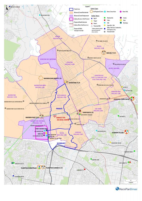
Table of contents

Executive summary                                                          i

Introduction                                                              iv

Section 1:     Site context, literature review and proposed development    1

      1.1    Regional and local context                                    1

      1.2    Strategic context                                             3

      1.3    West Schofields precinct                                      8

Section 2:     Trade area analysis                                        10

      2.1    Trade area definition                                        10

      2.2    Trade area population                                        13

      2.3    Socio-demographic profile                                    15

      2.4    Retail expenditure capacity                                  18

Section 3:     Competition                                                23

      3.1    Existing competition                                         23

      3.2    Proposed competition                                         27

Section 4:     Retail and commercial floorspace potential                 29

      4.1    Retail floorspace demand within West Schofields              29

      4.2    Recommended scale, mix, distribution and timing              32

Section 5:     Economic impacts                                           37

      5.1    Potential impacts on surrounding centres hierarchy           37

      5.2    Potential supportable employment                             39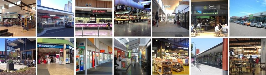
Executive summary
This report presents an independent assessment of the scale, mix and distribution of retail
and employment floorspace that could potentially be supported across the West Schofields
precinct and the required amount of business zoned land to support such floorspace.
This report also examines the appropriate timing of such floorspace and assesses the
economic impacts on the retail/activity centres throughout the surrounding region and
potential employment that could be sustained by such floorspace.
This report forms part of a suite of technical documents that are being prepared as part of
the masterplanning for the West Schofields precinct.
West Schofields precinct overview and potential dwelling yield capacity
The West Schofields precinct general includes two sub-precincts, the land to the north of
South Street and land to the south of South Street.
In the North West Land Use and Infrastructure Implementation Plan (2017), the West
Schofields precinct has been ear-marked to contain 4,300 homes. This exceeds what was
previously outlined within the North West Structure Plan in 2006 (2,000 homes).
Trade area analysis – population & retail floorspace demand
Convenience based retail/commercial facilities in the West Schofields precinct could
potentially serve a main trade area which includes two primary sectors and one
secondary sector.
The primary sector is defined in accordance within the boundaries of West Schofields
precinct.
The population of the main trade area is currently estimated to be around 3,300 persons
as at 2017, including around 900 persons within the West Schofields precinct itself. This
West Schofields Precinct
i
Retail and employment assessment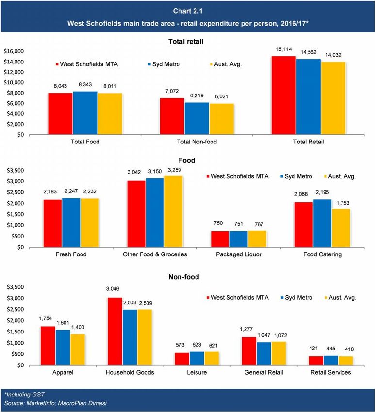
Executive summary
population is estimated to grow at an average annual growth rate of 7.4% to reach
18,560 persons by 2041, including 13,850 persons in the primary sector.
The population of the main trade area generates demand for around 7,100 sq.m of retail
floorspace in 2017, and is expected to increase to around 22,100 by 2026, and to
46,800 sq.m by 2041, equivalent to an increase of nearly 1,700 sq.m per annum.
Recommended retail/commercial floorspace & land requirements
We recommend the following mix and distribution of retail and ancillary non-retail facilities
be planned for in the West Schofields precinct:
Based on our analysis, including discussions in workshops and having regard to various
constraints, we recommend that one Local Centre be created within the centre of the
West Schofields precinct, around Schofields Road.
A centralised location within the estate will allow it to serve all residents more easily and
will allow greater critical mass and a more successful centre, as it can more readily
capture passing trade along Schofields Road.
We recommend a centre with around 5,500 sq.m of retail floorspace including a full scale
supermarket of 3,750 sq.m and around 1,500 sq.m of supporting specialty plus a further
1,500 sq.m of non-retail floorspace, i.e. total floorspace of around 6,500 – 7,000 sq.m.
Allowing for appropriate car-parking, set-backs, loading/unloading and circulation, we
have applied an FSR of 0.35-0.4:1 to the recommended floorspace provision to determine
the appropriate amount of business land required. Applying these FSR’s results in a land
requirement for around 1.7 – 1.9 hectares (ha) for the local centre.
West Schofields Precinct
ii
Retail and employment assessmentExecutive summary
Economic impacts
We note that the West Schofields precinct is estimated to support a population of around
13,850 persons by 2041, generating demand for around 46,800 sq.m of retail floorspace,
including 12,600 sq.m of supermarket floorspace demand.
Approximately 75 – 80% of the recommended supportable retail floorspace is expected to
be driven by demand from residents within the West Schofields precinct, with the
remaining 20 – 25% generated by residents of the secondary south sector and from
beyond the main trade area.
This means that around 3,100 sq.m (2026) to nearly 10,000 sq.m (2041) of supermarket
demand (52 – 78%) and 18,200 sq.m (2026) to 42,900 sq.m (2041) of total retail
floorspace demand (82 – 92%) generated by the West Schofields population will be
directed to other retail centres/precincts in the surrounding region.
In this context, all of the existing and proposed centres in the region will benefit
considerably from the new population that will establish within the West Schofields
precinct.
A local centre within the West Schofields precinct will facilitate permanent employment
opportunities, as well as further jobs throughout the supply chain, including those in
industries servicing the retail and commercial tenants at the site, such as transport
workers, wholesalers and the like.
We estimate the new local centre within the West Schofields precinct could potentially
support in the order 207 jobs over the longer term.
There will also other employment supported beyond these centres, for example jobs
created at schools and other community facilities that do not necessarily require business
zoned land to operate.
West Schofields Precinct
iii
Retail and employment assessmentIntroduction
This report presents an independent assessment of the scale, mix and distribution of retail
and employment floorspace that could potentially be supported across the West Schofields
precinct and the required amount of business zoned land to support such floorspace.
This report also examines the appropriate timing of such floorspace and assesses the
economic impacts on the retail/activity centres throughout the surrounding region and
potential employment that could be sustained by such floorspace.
The West Schofields precinct forms part of the North West Growth Area (NWGA). This report
forms part of a suite of technical documents that are being prepared as part of the
masterplanning for the West Schofields precinct. This retail and employment assessment
examines the requirements across the entire West Schofields precinct.
This report is presented in six sections as follows:
Section 1 presents an overview of the regional and local context of the West Schofields
precinct and the wider NWGA; provides a review of the relevant strategic planning and
economic documents of relevance; and provides an overview of the West Schofields
precinct including its preliminary dwelling capacity.
Section 2 examines the trade area that could potentially be served by retail/commercial
facilities within the West Schofields precinct; then provides estimates of current and
anticipated dwelling and population levels within this trade area; analyses the socio-
demographic profile of the future population; and assesses the current and future retail
expenditure volumes generated by the trade area population.
Section 3 reviews the surrounding retail/centres hierarchy of relevance to proposed
retail/commercial facilities in the West Schofields precinct, including all planned and
proposed centres of relevance.
West Schofields Precinct
iv
Retail and employment assessmentIntroduction
Section 4 translates the available retail expenditure market into estimates of retail
floorspace demand, and then assesses the appropriate scale, mix, distribution,
configuration of retail and commercial floorspace within the West Schofields precinct.
This section also provides advice on the appropriate amount of business zoned land to
support such floorspace including advice on carparking, etc.
Section 5 presents our estimates of potential economic impacts on the surrounding
retail/centres hierarchy; and discusses the implications of these impacts, and then
examines the net community benefits associated with the development of
retail/commercial facilities within the West Schofields precinct, including employment
generation and other economic benefits.
West Schofields Precinct
v
Retail and employment assessmentSection 1: Site context, literature review and
proposed development
This section presents an overview of the regional and local context of the West Schofields
precinct and the wider NWGA; provides a review of the relevant strategic planning and
economic documents of relevance; and provides an overview of the West Schofields precinct
including its preliminary dwelling capacity.
1.1 Regional and local context
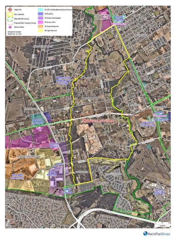
The West Schofields precinct is located in the suburb of Schofields in the NWGA of outer
metropolitan Sydney, approximately 45 – 50 km from the Sydney CBD (refer Map 1.1).
The NWGA is one of three major greenfield development areas in metropolitan Sydney and
is expected to accommodate in excess of 150,000 new dwellings over the next 25 – 30 years.
The South West GA and Western Sydney GA are the two other major growth areas, the latter
which includes the planned Western Sydney Airport. Furthermore, significant additional
residential dwelling growth is occurring, and will continue to occur, in areas located just
beyond the technical boundary of NWGA, including precincts such as Balmoral Road, Box Hill
North (i.e. The Gables) and Colebee.
The West Schofields precinct is located between the Marsden Park and Marsden Park
Industrial precincts to the west; the Schofields precinct to the east; the Colebee precinct to
the south; and the Marsden Park North and Riverstone West precincts to the north.
West Schofields Precinct
1
Retail and employment assessmentMap 1.1: West Schofields Regional context
Section 1: Site context, literature review and proposed development
The precinct is located in a highly accessible location a short distance from Richmond Road
and the M7. The precinct is accessible from Townson Road to Stonecutters Ridge/Colebee
and Greenway via Stonecutters Drive.
Development in the nearby Marsden Park Industrial Precinct is now well advanced with
several major retail tenants trading including Bunnings, IKEA, Costco and Aldi and the Lindt
Factory Outlet. There is also a 19,000 sq.m Home Hub homemaker centre and the previous
Masters building is being repurposed into smaller retail tenancies – generally of a household
goods nature.
In the surrounding area, strong housing growth has occurred and is continuing to occur at
Greenway, Townson Road and Stonecutters Ridge.
1.2 Strategic context
This sub-section of the report provides a review of key strategic documents of relevance to
retail and commercial development within the West Schofields precinct.
Greater Sydney Region Plan (2018)
Released by the Greater Sydney Commission (GSC) in March 2018, The ‘Greater Sydney
Region Plan’ will be used as a cornerstone reference for land-use planning decisions going
into the future.
The purpose of the draft Plan is to:
Set a 40-year vision (up to 2056) and establish a 20-year plan to manage growth and
change for Greater Sydney in the context of economic, social and environmental matters;
Inform district and local plans and the assessment of planning proposals;
Assist infrastructure agencies to plan and deliver for growth and change and to align their
infrastructure plans to place-based outcomes;
West Schofields Precinct
3
Retail and employment assessmentSection 1: Site context, literature review and proposed development
Inform the private sector of the vision for Greater Sydney and infrastructure investments
required to manage growth;
Inform and engage the wider community so the draft Plan can best reflect the values and
aspirations of all.
Essentially, the plan presents a strategy for accommodating Sydney’s future population
growth. It balances the need for more housing, but also cultivates the creation of strong and
resilient communities within a highly-liveable city whilst protecting the natural environment
and biodiversity.
New housing will be located close to jobs, public transport, community facilities and services.
It acknowledges the need to offer choice in housing location, size and typologies, to better
suit our lifestyles and budgets. Most importantly, more intensive housing development
across the city will be matched with investment in infrastructure and services, culture and
the arts, a ‘green-grid’ of open spaces and renewed bushland to support healthy lifestyles
and community life.
With specific reference to the NWGA, the plan highlights the need to retain and manage the
growth area. As such, the plan suggests that all existing industrial and urban services and
land should be safeguarded from competing pressures, being retained for economic
activities required for Greater Sydney’s future growth and operation. In achieving this, a mix
of economic outcomes that support employment, the city and its population would be
desirable. The further management of these lands should accommodate evolving business
practices and changes in needs for urban services from the surrounding community and
businesses.
Furthermore, the NSW Government has identified demand for 725,000 homes to meet
growth over the next 20 years and the draft Plan sets out a process to deliver a steady
pipeline of supply to meet this forecast housing demand and to improve Greater Sydney’s
housing affordability. To this end, housing targets have been established to support the
creation of supply for delivery over the next ten years and to create capacity for the longer
West Schofields Precinct
4
Retail and employment assessmentSection 1: Site context, literature review and proposed development
term. Key actions include the preparation of housing strategies and the development of
housing targets across the greater metropolitan area for each of the Districts and each local
government area.
In the case of the subject precinct, which is located in the Central City District, the 0-5 year
(2016-2021) housing supply target and the 20-year (2016-2036) strategic housing target is
53,500 and 207,500 dwellings, respectively. This equates to an average annual supply of
10,375 dwellings, or approximately one in four of all new homes in Greater Sydney over the
next 20 years, across the entire District.'
Central City District Plan (2018)
The Greater Sydney Commission (GSC) issued its first District Plan in March 2018. The Plan
looks to bridge regional and economic planning to allow for sustained economic, social and
environmental development within Greater Sydney.
Under the Central City District Plan, the NGA is recognised as one of the largest growth areas
along with the South West and Wilton Growth Areas and the southern part of the Greater
Macarthur Growth Area.
The GSC envisages the Central City be the fastest growing District over the next 20 years,
potentially accommodating up to 207,500 dwellings. There is no specific mention of the
dwelling targets/yield for the NWGA, nor West Schofields in the District Plan.
Marsden Park (Strategic Centre) is identified as the largest centre in the NWGA and other
‘local centres’ are identified at Riverstone, Schofields. A train link/investigation corridor is
identified extending from Cudgegong Road through to Marsden Park.
West Schofields Precinct
5
Retail and employment assessmentSection 1: Site context, literature review and proposed development
North West Land Use and Infrastructure Implementation Plan (LUIIP) (2017)
Since 2006, nearly two-thirds of the growth area have been rezoned (under the North West
Structure Plan 2006) with five precincts yet to be rezoned.
In May 2017, the LUIIP replaced the North West Structure Plan (2006) and sets the
overarching strategic plan for the NWGA five remaining precincts. In doing so, it guides the
Precinct Planning and rezoning process that confirms land uses, street patterns,
environmental and heritage protection, and detailed infrastructure requirements.
Under the LUIIP, the NWGA could ultimately provide up to an additional 20,000 dwellings
than was anticipated in the 2006 Structure Plan (90,000 dwellings in total). Furthermore, the
plan seeks to facilitate the supply of 18,000 new homes by 2021 and 33,000 new homes by
2026.
West Schofields is one of the projects which will be rezoned under the guidelines of the
Implementation Plan. There are numerous assumptions that will be taken into consideration
with regards to rezoning, including:
Land use opportunities adjacent to the Outer Sydney Orbital
Local infrastructure requirements, such as school and open space
Local and regional connectivity with respect to bike paths, pedestrian paths and the
Green Grid.
Riverstone East Precinct – Retail and Economic and Employment Assessment - SGS
(2014)
Riverstone East is one of the most recent precincts to go through its public exhibition phase,
which was on exhibition late 2015.
The SGS Retail and Employment Report (2014) that formed part of the technical reports for
the rezoning of this precinct adopted a methodology for examining retail floorspace demand
West Schofields Precinct
6
Retail and employment assessmentSection 1: Site context, literature review and proposed development
that we consider underestimates the real potential for retail floorspace within that precinct
and is considered very conservative.
We note that there is no rail infrastructure planned in this precinct, however, the report
recommended a small neighbourhood centre of 2,400 sq.m for an estimated population of
15,000 residents (5,300 dwellings) at the time. It is noted that in the LUIIP (2017), the
anticipated number of supportable dwellings in this precinct has increased to 5,800.
Nonetheless, to put this in context; applying a general rule of thumb of around 2.2 sq.m per
persons, a population of around 15,000 residents would generate demand for around
33,000 sq.m of retail floorspace, including at least one full-line supermarket (3,500 –
4,000 sq.m) and possibly a second medium sized supermarket (2,000 – 2,500 sq.m). This
means that just 6% - 7% of retail floorspace demand generated by this population is planned
to be serviced by retail facilities within this precinct.
While there are surrounding precincts adjacent to West Schofields that will support retail
facilities in the future, it is very important that the local communities in each of the new
precincts being planned for in the NWGA are provided with sufficient amount and diversity
of local convenience retail services – not only to minimise travel times/costs, but to provide
local employment, local community hubs, viable/diverse centres, and temper over-
trading/congestion at other centres in the surrounding hierarchy (i.e. provide some degree
of self-sufficiency).
The reason that we have presented Riverstone East as a comparison is because the potential
dwelling yield at West Schofields is expected to be in the order of 4,300 dwellings (i.e. less
than Riverstone East) but our preliminary analysis indicates that the precinct could support
well in excess of 2,400 sq.m of retail floorspace. We note that the Riverstone East precinct is
a relatively low density precinct. Both West Schofields and Riverstone East are in proximity
to the existing and proposed station however, it is noted that neither have direct access.
West Schofields Precinct
7
Retail and employment assessmentSection 1: Site context, literature review and proposed development
1.3 West Schofields precinct
The West Schofields precinct is separated into two sub-precincts, the land to the north of
South Street and land to the south of South Street (which includes some existing dwellings in
the Townson Road area (refer Map 1.2).
This retail and employment assessment report pertains to the whole West Schofields
precinct.
The LUIIP outlines that the West Schofields precinct is expected to accommodate
4,300 homes, which exceeds what was previously outlined in the North West Structure Plan
in 2006 (2,000 homes).
This report examines the appropriate size, composition, distribution and timing of retail and
employment floorspace within the West Schofields precinct and the required size and scale
of the business land that would be required to accommodate such floorspace.
Our analysis has been prepared having regard to significant increase in potential dwelling
densities and subsequent yield that could be generated across the whole West Schofields
precinct.
West Schofields Precinct
8
Retail and employment assessmentMap 1.2: West Schofields precinct Site location
Section 2: Trade area analysis
This section of the report examines the trade area that could potentially be served by
retail/commercial facilities within the West Schofields precinct; then provides estimates of
current and anticipated dwelling and population levels within this trade area; analyses the
socio-demographic profile of the future population; and assesses the current and future
retail expenditure volumes generated by the trade area population.
2.1 Trade area definition
The extent of the trade area or catchment that is served by any shopping centre, or retail
facility, is shaped by the interplay of a number of critical factors. These factors include:
The relative attraction of the centre, in comparison with alternative competitive retail
facilities. The factors that determine the strength and attraction of any particular centre
are primarily its scale and composition (in particular the major trader or traders that
anchor the centre); its layout and ambience; and car parking, including access and ease of
use.
The proximity and attractiveness of competitive retail centres. The locations,
compositions, quality and scale of competitive retail facilities all serve to define the
extent of the trade area which a shopping centre is effectively able to serve.
The available road network and public transport infrastructure, which determine the ease
(or difficulty) with which customers are able to access a shopping centre.
Significant physical barriers which are difficult to negotiate, and can act as delineating
boundaries to the trade area served by an individual shopping centre.
West Schofields Precinct
10
Retail and employment assessmentSection 2: Trade area analysis
The trade area which could potentially be served by potential retail facilities in the
West Schofields precinct has been defined taking into consideration all of the above factors,
in particular the following:
i. The southern part of the West Schofields precinct is expected to accommodate the
majority of new housing in the West Schofields precinct.
ii. The boundaries of the West Schofields precinct.
iii. The existing and planned traditional retail facilities at Marsden Park Industrial Estate
(i.e. Aldi), Greenway Village Centre (i.e. Woolworths) and Marsden Park Town Centre.
iv. The lack of convenience/supermarket facilities in the Stonecutters Ridge estate.
v. The existing Woolworths Schofields and planned future development of the Schofields
Town Centre and the planned smaller centres in the Schofields precinct.
vi. The existing retail facilities at Riverstone and planned future development of the
Riverstone Town Centre.
Map 2.1 illustrates the trade area, which includes one primary sector and one secondary
sector, described as follows:
The primary sector matches the boundaries of the West Schofields precinct.
The secondary south sector includes the Greenway Estate, Townson Road Estate and
Stonecutters Ridge Estate, and is generally bounded by Townson Road to the north,
Eastern Creek to the east, Westlink M7 Motorway to the south and Richmond Road to the
west. We expect that the market shares retained from this sector would be lower than for
each of the two primary sectors.
The primary sector and secondary sectors in combination will be referred to as the
main trade area throughout the rest of this report.
West Schofields Precinct
11
Retail and employment assessmentMap 2.1: West Schofields precinct Trade area and competition
Section 2: Trade area analysis
2.2 Trade area population
Table 2.1 details the current and projected population levels within the main trade area over
the period 2011 to 2041. This information has been collected from a range of sources,
including the following:
Australian Bureau of Statistics Census of Population and Housing (2011 and 2016);
Australian Bureau of Statistics Dwelling Approvals Data (2012 - 2017);
Australian Bureau of Statistics Estimated Residential Population Data (ERP) (2016);
NSW Transport Performance and Analytics (TPA) (2017);
Other investigations of future residential development, undertaken by this office.
The main trade area population is estimated at 3,310 persons as at June 2017, including
approximately 900 residents within the West Schofields precinct itself.
Over the most recent intercensal period (2011 - 2016), main trade area population growth
was significant, driven by rapid dwelling construction in Stonecutters Ridge, Greenway and
Tomson Road estates. The population grew around 20% p.a. over this time, almost tripling in
size. Virtually all of this growth occurred in the secondary south sector.
West Schofields Precinct
13
Retail and employment assessmentSection 2: Trade area analysis
Table 2.1
West Schofields trade area population, 2011-2041*
Estimated population Forecast population
Trade area sector 2011 2016 2017 2021 2026 2031 2036 2041
Primary 880 880 900 2,100 5,850 10,850 13,350 13,850
Secondary 160 1,990 2,410 3,610 4,010 4,260 4,510 4,710
Main trade area 1,040 2,870 3,310 5,710 9,860 15,110 17,860 18,560
Average annual growth (no.)
Trade area sector 2011-16 2016-17 2017-21 2021-26 2026-31 2031-36 2036-41
Primary 0 20 300 750 1,000 500 100
Secondary 366 420 300 80 50 50 40
Main trade area 366 440 600 830 1,050 550 140
Average annual growth (%)
Trade area sector 2011-16 2016-17 2017-21 2021-26 2026-31 2031-36 2036-41
Primary 0.0% 2.3% 23.6% 22.7% 13.2% 4.2% 0.7%
Secondary 65.6% 21.1% 10.6% 2.1% 1.2% 1.1% 0.9%
Main trade area 22.5% 15.3% 14.6% 11.5% 8.9% 3.4% 0.8%
*As at June
Source: ABS Census 2016; NSW DPE; Urbis; MacroPlan Dimasi
The following major residential developments will be the key drivers of population growth
within the main trade area:
The CSR landholdings and immediate surrounds is expected to be the main driver of
population growth within the main trade area. We have assumed that development
could occur from 2019/20 with take-up rates of around 150-250 dwellings per annum.
The northern part of the West Schofields precinct is expected to be developed over the
longer term.
Greenway estate is an estate currently underway in the secondary sector, which could
potentially deliver around 550 – 600 dwellings once fully built out, with more than half
the estate built as at November 2017.
Stonecutters Ridge is an estate under construction in the secondary sectors, which is
planned to including 904 dwellings, all of which have been sold. The majority of the
West Schofields Precinct
14
Retail and employment assessmentSection 2: Trade area analysis
estate is now developed, with the remaining dwellings expected to be delivered over the
next few years.
The Townson Road Estate is located adjacent to the Greenway Estate on Townson Road,
is expected to accommodate around 336 dwellings upon completion.
Having regard to the above, the main trade area population is estimated to grow at an
average annual growth rate of 7.4% to reach 18,560 persons by 2041, including
13,850 persons in the primary sector.
2.3 Socio-demographic profile
Table 2.2 illustrates the socio-demographic profile of the main trade area population,
compared with benchmarks for metropolitan Sydney and Australia and a proxy Greenfield
growth area, based on data from the 2016 ABS Census of Population and Housing, with the
key highlights as follows:
The average per capita income of the main trade area population is 4.1% above the
Sydney average, but average household incomes are 27.2% above average – due to a
larger average household size (3.3 persons per household v 2.7 Sydney average).
The average age of the main trade area population is 33.6 years, which is significantly
lower than the Sydney average of 37.5 years. This reflects the relatively high proportion
of children (22.8%) and the low proportion of residents aged over 60 years (11.7%),
compared to the Sydney metropolitan average, particularly in the secondary sector.
The home ownership level within main trade area, at 83.4%, is significantly higher than
the Sydney average of 64.2%, with most homeowners (70-75%) in the process of buying
their homes (i.e. paying off a mortgage).
Australian born residents account for 59.8% of the main trade area population, which is
broadly in line with the Sydney average. However, the main trade area includes a higher
than average proportion of Asian born residents (23.6%), with particularly high
representation from Indian born and Philippines born residents in the secondary sector.
West Schofields Precinct
15
Retail and employment assessmentSection 2: Trade area analysis
Traditional families (i.e. couples with dependent children) are the most prevalent
household type in the main trade area, accounting for 59.6% of households, well above
the Sydney average of 48.5%. Compared to the Sydney metropolitan average, the main
trade area has a low proportion of couples without children (17.2% vs 20.1%) and lone
person households (3.6% vs 9.2%).
Around 79% of households own two or more cars, which is much higher than the Sydney
metropolitan average (50%), and there is a much lower than average proportion of zero
car households (0.7% v Sydney average of 11.4%).
The main trade area is characterised by a relatively young and affluent population, with
relatively high home ownership levels compared to the Sydney metropolitan average, and an
increasingly Asian born population base (i.e. Indian, and south-east Asian).
West Schofields Precinct
16
Retail and employment assessmentSection 2: Trade area analysis
Table 2.2
West Schofields main trade area - socio-demographic profile, 2016
Primary Secondary Main Proxy Area Syd Metro Aust.
Census item sector sectors TA Socios* avg. avg.
Per capita income $35,387 $52,110 $47,006 $47,852 $45,173 $39,800
Var. from Syd Metro bmark -21.7% 15.4% 4.1% 5.9%
Avg. household income $107,579 $182,522 $157,338 $163,729 $123,654 $101,610
Var. from Syd Metro bmark -13.0% 47.6% 27.2% 32.4%
Avg. household size 3.0 3.5 3.3 3.4 2.7 2.6
Age distribution (% of population)
Aged 0-14 18.4% 24.8% 22.8% 27.4% 18.7% 18.7%
Aged 15-19 6.9% 6.5% 6.6% 6.9% 6.0% 6.1%
Aged 20-29 11.5% 13.9% 13.2% 10.2% 15.0% 13.8%
Aged 30-39 13.2% 20.1% 18.0% 18.1% 15.5% 14.0%
Aged 40-49 13.0% 17.1% 15.8% 17.6% 13.7% 13.5%
Aged 50-59 14.7% 10.6% 11.8% 9.8% 12.2% 12.7%
Aged 60+ 22.3% 7.1% 11.7% 9.9% 18.9% 21.1%
Average age 39.1 31.1 33.6 31.8 37.5 38.6
Housing status (% of households)
Owner (total) 75.3% 87.5% 83.4% 79.9% 64.2% 67.4%
• Owner (outright) 47.3% 10.2% 22.7% 17.7% 30.0% 31.9%
• Owner (with mortgage) 28.0% 77.3% 60.7% 62.2% 34.2% 35.5%
Renter 24.7% 12.5% 16.6% 19.9% 35.1% 31.8%
Birthplace (% of population)
Australian born 74.5% 53.4% 59.8% 59.8% 60.9% 71.9%
Overseas born 25.5% 46.6% 40.2% 40.2% 39.1% 28.1%
• Asia 7.1% 30.9% 23.6% 23.2% 19.1% 11.2%
• Europe 12.9% 3.4% 6.3% 6.3% 9.6% 9.6%
• Other 5.5% 12.2% 10.2% 10.8% 10.4% 7.4%
Family type (% of households)
Couple with dep't child. 41.4% 68.8% 59.6% 69.5% 48.5% 44.8%
Couple with non-dep't child. 17.5% 8.2% 11.3% 7.8% 9.1% 7.7%
Couple without child. 21.3% 15.2% 17.2% 12.4% 20.1% 22.8%
One parent with dep't child. 9.1% 4.0% 5.7% 5.0% 7.9% 8.8%
One parent w non-dep't child. 3.3% 1.5% 2.1% 1.9% 4.1% 3.7%
Lone person 7.3% 1.8% 3.6% 3.0% 9.2% 11.0%
Car ownership
% 0 Cars 2.1% 0.0% 0.7% 1.2% 11.4% 7.7%
% 1 Car 27.4% 17.3% 20.4% 23.0% 38.5% 36.1%
% 2 Cars 35.4% 55.3% 49.1% 51.7% 34.0% 37.5%
% 3 Cars 12.7% 19.8% 17.5% 16.5% 10.5% 12.2%
% 4 plus Cars 22.4% 7.7% 12.3% 7.5% 5.7% 6.5%
*Proxy area represents the population profile of Stanhope/The Ponds
Source: ABS Census of Population & Housing, 2016; MacroPlan Dimasi
West Schofields Precinct
17
Retail and employment assessmentSection 2: Trade area analysis
2.4 Retail expenditure capacity
MacroPlan Dimasi estimates retail expenditure capacity generated by the main trade area
residents based on information sourced from Market Data Systems (MDS), which utilises a
detailed micro simulation model of household expenditure behaviour for all residents of
Australia. The model takes into account information from a wide variety of sources including
the regular ABS Household Expenditure Surveys, national accounts data, Census data and
other information. We consider MarketInfo data to be an accurate measure of available
retail expenditure and it is widely relied on in the retail industry.
Total retail expenditure is detailed in a number of categories, as follows:
Take-home food and groceries – goods typically sold in supermarkets and specialty fresh
food stores.
Packaged liquor – packaged beer, wine and spirits such as those purchased at bottle-
shops and liquor outlets.
Food catering – cafes, take-away outlets and restaurants, including liquor consumed on
such premises.
Apparel – clothing, footwear, fashion and accessories.
Household Goods – giftware, electrical, computers, furniture, homewares, and hardware
goods.
Leisure – sporting goods, music, DVDs, games, books, newsagents and film
processing/photography.
General Retail –pharmaceutical goods, cosmetics, toys, florists, mobile phones.
Retail Services – retail services such as key cutting, shoe repairs, hair and beauty.
West Schofields Precinct
18
Retail and employment assessmentSection 2: Trade area analysis
Chart 2.1 shows the potential retail expenditure capacity per person for residents of the
proxy trade area for the year 2016/17, based on the spending characteristics of the proxy
region (i.e. Stanhope/The Ponds), and compares these estimates with the average for
metropolitan Sydney and Australia. Expenditure estimates are presented inclusive of GST.
The following points are noted:
Estimated retail expenditure per capita is around 4% above the metropolitan Sydney
average. However, due to the high average household size of the main trade area
population relative to Sydney, retail expenditure per household is 27% above average.
Estimated per capita expenditure on fresh food and other food and groceries, key
categories of relevance to supermarkets, is slightly lower than the Sydney average,
although on per household basis, it is around 18 – 19% above average.
Spend per capita on discretionary retail categories is 14% higher than the Sydney average.
This is driven by the particularly high per capita expenditure on household goods and
general retail, which are each 22% higher than the Sydney average.
Table 2.3 combines Table 2.1 and Chart 2.1 and presents estimates of total retail expenditure
generated by the main trade area population, by trade area sector, over the period from
2017 to 2041. Retail expenditure forecasts are presented inclusive of GST and in constant
2016/17 dollars.
The retail expenditure market is expected to grow from about $47 million in 2017 to
$347 million ($2017) by 2041, at an average annual growth rate of 8.7%. The average annual
growth rate of 8.7% comprises two components, as follows:
Residential population growth, which is expected to average 7.8% per annum; and
Real growth in per capita retail expenditure, which is expected to average 0.9% per
annum over the forecast period; and
The total retail expenditure capacity of primary sector residents is expected to grow from
$13 million at 2017 to $259 million by 2041.
West Schofields Precinct
19
Retail and employment assessmentSection 2: Trade area analysis
West Schofields Precinct
20
Retail and employment assessmentSection 2: Trade area analysis
Table 2.3
West Schofields main trade area - retail expenditure ($M), 2017-2041*
Year ending Primary Secondary Main
June sector sector TA
2017 13 33 47
2021 30 54 83
2026 87 65 152
2031 175 73 247
2036 235 80 315
2041 259 88 347
Average annual growth ($M)
2017-2041 10.2 2.3 12.5
Average annual growth (%)
2017-2041 13.1% 4.2% 8.7%
*Constant 2016/17 dollars & including GST
Source: MarketInfo; MacroPlan Dimasi
Table 2.4 presents estimates of expenditure for the main trade area by retail category.
FLG expenditure (i.e. expenditure on take-home food and groceries including packaged
liquor), a key category of relevance for supermarkets, is estimated at $18 million in 2017,
and accounts for 40% of all retail expenditure in the trade area. FLG expenditure by trade
area residents is forecast to increase to $140 million by 2041, at 8.8% per annum.
West Schofields Precinct
21
Retail and employment assessmentSection 2: Trade area analysis
Table 2.4
West Schofields main trade area - retail expenditure by category ($M), 2017-2041*
Year ending FLG Food Apparel Household Leisure General Retail Total
June catering goods retail services retail
2017 18 6 5 9 2 4 1 47
2021 33 12 10 17 3 7 2 83
2026 60 22 17 30 6 12 4 152
2031 99 37 27 49 9 20 7 247
2032 107 40 29 52 9 21 8 266
2036 127 48 34 62 11 25 9 315
2041 140 55 37 67 12 27 10 347
Average annual growth ($M)
2017-2041 5.1 2.0 1.3 2.4 0.4 0.9 0.4 12.5
Average annual growth (%)
2017-2041 8.8% 9.4% 8.3% 8.6% 8.3% 8.3% 8.8% 8.7%
*Constant 2016/17 dollars & including GST
Source: MarketInfo; MacroPlan Dimasi
Retail expenditure category definitions:
FLG: take-home food and groceries, as well as packaged liquor.
Food catering: expenditure at cafes, take-away food outlets and restaurants.
Apparel: clothing, footwear, fashion accessories and jewellery.
Household goods: giftware, electrical, computers, furniture, homewares and hardware goods.
Leisure: sporting goods, music, DVDs, computer games, books, newspapers & magazines, stationery and
photography equipment.
General retail: pharmaceutical goods, cosmetics, toys, florists, mobile phones and pets.
Retail services: hair & beauty, optical goods, dry cleaning, key cutting and shoe repairs.
West Schofields Precinct
22
Retail and employment assessmentSection 3: Competition
This section of the report outlines the retail/centres hierarchy, of relevance to
retail/commercial facilities at West Schofields, including planned centres and proposed
developments of relevance.
3.1 Existing competition
Table 3.1 details the existing retail facilities of relevance to retail/centre facilities being
developed at West Schofields, while the previous Map 2.1 illustrates the locations of these
facilities as well as the planned centres in the region. There are three existing sub-regional
centres in the surrounding region, summarised as follows:
Plumpton Marketplace is a sub-regional centre located about 5 – 6 km south of the
potential centre in the West Schofields precinct. The centre includes 17,100 sq.m of
retail floorspace and is anchored by a Big W discount department store (DDS) and a
Woolworths supermarket, with around 60 - 65 specialty shops.
Rouse Hill Town Centre is a large sub-regional shopping centre located around 10 km
east of the subject site. The centre contains around 51,700 sq.m of retail floorspace and
is anchored by Big W, Target, Woolworths and Coles. The centre also accommodates
more than 200 specialty and mini-major tenants. Rouse Hill Town has in-principle
approval for around 100,000 sq.m of retail floorspace, i.e. the centre has approval to
almost double in size. It is noted that GPT has previously lodged a DA for a $300 million
expansion of the centre which would have added around 29,000 sq.m of floorspace,
including a new department store. This development application has since been
withdrawn, however, we do anticipate a future expansion of the centre over the
medium term.
Elsewhere in Rouse Hill there is an estimated additional 4,500 – 5,000 sq.m of retail
floorspace, including Aldi and IGA supermarkets.
West Schofields Precinct
23
Retail and employment assessmentSection 3: Competition
Stanhope Village is a successful 16,400 sq.m sub-regional shopping centre located
around 12 km east of the subject site. The centre is anchored by a Kmart DDS, as well as
Coles and Aldi supermarkets and contains around 65 – 70 specialty shops.
Greenway Village is the closest supermarket based centre, with around 4,000 –
4.500 sq.m of retail floorspace, including a Woolworths supermarket of 3,400 sq.m, a
BWS liquor store, newsagency, cafe, bakery, hair salon and a phone repair shop.
Sydney Business Park is a major large format retail precinct which accommodates
around 70,000 sq.m of retail floorspace in total, including Costco, Bunnings Warehouse,
IKEA, an Aldi supermarket as well as smaller tenancies such as a McDonald’s restaurant
and a service station. In addition, the precinct contains Home Hub, which is a large
homemaker centre accommodating 28 tenants. The ex-Masters box will be repurposed
to accommodate several retail tenancies.
Woolworths Schofields is a small neighbourhood convenience centre of around
4,500 sq.m, which contains a Woolworths supermarket, a BWS liquor store, a
Terry White Chemist and an H Café pad site. There are also 5-6 shops just north of the
centre, in a small retail precinct on Railway Parade.
Quakers Hill contains a standalone Aldi supermarket of around 1,300 sq.m located on
Hambleton Road and a small IGA anchored Quakers Hill Shopping Village, which
contains around 2,500 sq.m of retail floorspace.
Riverstone Marketown is a tired, run-down retail asset located near the Riverstone
railway station which contains around 2,500 sq.m of retail floorspace including a small
IGA supermarket. A development approval exists for an expansion of the centre to
accommodate an additional 7,200 sq.m of retail GLA, including two supermarkets (refer
section 3.2). There is also around 1,000 sq.m of street retail in the town centre.
Quakers Court Shopping Centre is a neighbourhood centre of around 5,100 sq.m, which
is anchored by a Woolworths supermarket and contains 10 - 12 specialty shops, and
Woodcroft Village is a Coles anchored shopping centre, with around 8-10 specialty
shops, totalling 4,500 sq.m.
West Schofields Precinct
24
Retail and employment assessmentSection 3: Competition
Emerton Village Shopping Centre is a dated neighbourhood centre which currently
contains around 7,600 sq.m of retail floorspace and is anchored by a Woolworths
supermarket. The centre has a DA approval for a solid expansion, including an expansion
to the existing Woolworths and possibly a new Aldi supermarket (refer section 3.2)
The Ponds Shopping Centre is a neighbourhood centre containing 7,500 sq.m of retail
GLA, anchored by a large Woolworths supermarket of 4,200 sq.m. The centre also
accommodates 23 specialty tenants.
Kings Langley accommodates around 8,700 sq.m of retail floorspace, including the
5,200 sq.m Kings Langley Shopping Centre, which is anchored by a Coles supermarket. In
addition, there is a Woolworths supermarket of 3,500 sq.m, directly opposite the centre.
Glenwood Park Shopping Village is a small neighbourhood centre which contains 3,100
– 3,200 sq.m of retail floorspace and incorporates a Woolworths supermarket of
2,540 sq.m and 9 specialty tenants.
West Schofields Precinct
25
Retail and employment assessmentSection 3: Competition
Table 3.1
West Schofields - schedule of competing retail facilities
Retail Dist. by road from
Centre GLA Major traders West Schofields
(sq.m) (km)*
Existing facilities
Sydney Business Park 70,000 IKEA, Bunnings, Aldi, Home Hub, Costco 1.5
Greenway Village 4,300 Woolworths 2.2
Schofields TC 35,000 5.0
• Woolworths Schofields 4,500 Woolworths
• Coles SC (p) 5,000 Coles (p)
• Proposed (Long Term) 25,000 DDS (p), Supermarket (p)
Plumpton Town Centre 34,800 5.2
Plumpton Marketplace 17,100 Big W, Woolworths
Plumpton Gardens (p) 17,700 Coles (p), Aldi (p), DDS (p)
Riverstone TC (p) 30,000 5.5
• Riverstone Marketown (existing) 2,500 IGA
• Riverstone Marketown (p) 7,200 Unknown supermarket (x2) (p)
• Other 1,000
• Future potential 30,000 Unknown DDS (p), Unknown supermarket (p)
Woodcroft Village 4,500 Coles 6.6
Quakers Court 5,100 Woolworths 7.6
Emerton Village SC 10,600 7.7
• Existing 7,600 Woolworths
• Proposed 3,000 Aldi (p), exp. WOW (p)
Quakers Hill 3,800 10.0
• Quakers Hill Village 2,500 IGA
• Other 1,300 Aldi
Rouse Hill TC 105,000 10.3
• Rouse Hill TC (existing) 51,700 Target, Big W, Woolworths, Coles
• Rouse Hill TC (future stages) 48,300 Note: totalling 100,000 sq.m
• Other 5,000 Aldi, IGA
The Ponds SC 7,500 Woolworths 10.6
Kings Langley 8,700 10.7
• Kings Lanley SC 5,200 Coles
• Other 3,500 Woolworths
Glenwood Park Shopping Village 3,200 Woolworths 11.2
Stanhope Village 16,400 Kmart, Coles, Aldi 12.2
Future facilities
Marsden Park precinct 4.0 - 6.0
• Marsden Park TC (p) 30,000 - 35,000 DDS (p), Supermarket (x2) (p)
• Marsden Park VC 1 (p) c. 5,000 Supermarket (p)
• Marsden Park VC 2 (p) c. 5,000 Supermarket (p)
• Marsden Park Mixed Use (p) 1,500 n.a.
Riverstone East
• Riverstone East VC (p) 2,400 Supermarket (p) 6.0 - 7.0
Schofields Precinct 6.0 - 8.0
• Schofields VC 1 (p) c. 5,000 Supermarket (p)
• Schofields VC 2 (p) c. 5,000 Supermarket (p)
• Schofields NC (p) n.a. Supermarket (p)
Box Hill Precinct
• Box Hill TC (p) 30,000 DDS (p), Supermarket (x2) (p) 10.0 - 12.0
• Box Hill VC 1 (p) c. 5,000 Supermarket (p)
• Box Hill VC 2 (p) c. 5,000 Supermarket (p)
• Box Hill VC 3 (p) c. 5,000 Supermarket (p)
*Includes Masters floorspace
Source: Property Council of Australia; MacroPlan Dimasi
West Schofields Precinct
26
Retail and employment assessmentSection 3: Competition
3.2 Proposed competition
The NWGA is expected to accommodate significant new retail development in the future to
support the significant future population including new town centres, smaller local centres
and expansions to existing centres. There are currently no proposed retail facilities within in
the main trade area, other than the subject development. Beyond the trade area, the
following proposed centres are planned:
Marsden Park Precinct
Marsden Park Town Centre is planned to accommodate up to 30,000 – 35,000 sq.m of
retail/commercial floorspace over the long term, including discount department store(s)
and at least two supermarkets.
Two Village Centres are also planned within the Marsden Park precinct, both of which
could contain up to 5,000 sq.m of retail/commercial floorspace including a supermarket.
A DA has been lodged for a mixed used development in Marsden Park south of the town
centre, which could include around 860 dwellings and 1,500 sq.m of retail floorspace.
This could potentially include small scale convenience and F&B facilities. It is noted that
in its current form, the DA for this development has been refused and an appeal to the
decision has since been lodged.
Marsden Park North
Currently under precinct planning, expected to support some neighbourhood/local
centre type retail as the precinct develops.
Riverstone/Riverstone East
Riverstone Town Centre is earmarked to accommodate around 30,000 sq.m of retail and
commercial floorspace. Riverstone Marketown forms part of this town centre and, as
mentioned previously, has approval for a 7,200 sq.m net increase in retail GLA including
two supermarkets.
Two neighbourhood centres are planned within the Riverstone precinct, near the
Vineyard train station, and between Riverstone and Schofields train stations.
The indicative layout plan for Riverstone East indicates one village centre.
West Schofields Precinct
27
Retail and employment assessmentSection 3: Competition
Schofields
Schofields Town Centre is planned to accommodate up to 30,000 – 40,000 sq.m of
retail/commercial floorspace over the long term, potentially including discount
department stores and at least two supermarkets. Coles owns a site within the
Schofields Town Centre at the intersection of Schofields Road and Railway Terrace, for
which it has DA approval for the first stage of development, consisting of a 4,200 sq.m
Coles supermarket and around 700 sq.m of specialty space.
There is a small neighbourhood centre planned in the Schofields precinct between
West Schofields and the railway line which could contain a small supermarket, and two
local centres earmarked in the southern part of the Schofields precinct.
Box Hill
Box Hill Town Centre is planned to accommodate up to 30,000 sq.m of
retail/commercial GLA. This centre is a significant distance from the subject site and will
serve a different catchment to the West Schofields Neighbourhood Centre.
Three village centres are also planned across the Box Hill and Box Hill Industrial
precincts, which are expected to each contain around 5,000 sq.m of retail floorspace.
The Nelson Road Village Centre was recently approved, which will include a full service
supermarket of 3,000 sq.m.
Plumpton/Emerton
Plumpton Gardens SC is a proposed sub-regional centre planned to be located
immediately east of the existing Plumpton Marketplace. The proposed centre is planned
to include a discount department store, a full-line supermarket and a discount
supermarket.
As mentioned previously, there is approval for a major expansion and refurbishment of
around 3,000 sq.m at Emerton Village. The expansion is planned to include a new Aldi
supermarket as well as an expansion to the existing Woolworths supermarket. Plans for
the expansion are currently deferred. Given that a discount supermarket is also
proposed at Plumpton Gardens SC, it is uncertain if the Emerton Village expansion will
proceed as planned.
West Schofields Precinct
28
Retail and employment assessmentSection 4: Retail and commercial floorspace potential
This section of the report translates the available retail expenditure market into estimates of
retail floorspace demand, and then assesses the appropriate scale, mix, distribution,
configuration of retail and commercial floorspace within the West Schofields precinct. This
section also provides advice on the appropriate amount of business zoned land to support
such floorspace including advice on carparking, etc
4.1 Retail floorspace demand within West Schofields
To assess the potential supportable floorspace within the West Schofields precinct, we have
first translated the available retail expenditure market estimated in Tables 2.3 and 2.4 into
estimates of retail floorspace demand, by applying appropriate average retail turnover
densities (RTDs) for each broad retail expenditure category. We have applied RTDs in 2017
which have then been grown forward by around 0.5% per annum.
Due to the long term planning horizon being considered, the diverse range/mix of retail, and
the varying performance levels of certain retail categories and centre types, these estimates
should be considered as indicative in nature.
Table 4.1 summarises the estimated retail floorspace demand generated by the main trade
area population over the period 2017 to 2041.
As shown, the population of the main trade area generates demand for around 7,100 sq.m of
retail floorspace in 2017, equivalent to around 2.3 sq.m per person. This demand is expected
to increase to around 22,100 by 2026, and to 46,800 sq.m by 2041, equivalent to an increase
of nearly 1,700 sq.m per annum.
West Schofields Precinct
29
Retail and employment assessmentSection 4: Retail and commercial floorspace potential
Table 4.1
West Schofields main trade area - Estimated retail floorspace demand (sq.m), 2017-2041
Year ending FLG Food Total Apparel H'hold Leisure General Retail Total Total
June catering food goods retail services non-food retail
2017 1,868 1,027 2,900 871 2,261 285 634 179 4,230 7,130
2021 3,292 1,846 5,140 1,506 3,945 492 1,096 315 7,350 12,490
2026 5,866 3,372 9,240 2,617 6,943 855 1,905 561 12,880 22,120
2031 9,386 5,530 14,920 4,084 10,971 1,334 2,973 898 20,260 35,180
2036 11,705 7,068 18,774 4,968 13,514 1,623 3,617 1,120 24,843 43,616
2041 12,634 7,820 20,450 5,231 14,406 1,709 3,808 1,209 26,360 46,810
RTD* 9,850 6,200 8,500 6,200 4,150 6,200 6,200 7,250 5,100 6,500
*Retail Turnover Density - Turnover ($) per sq.m in 2017, growth assumed at 0.5% p.a
Source: MarketInfo; MacroPlan Dimasi
Because West Schofields is smaller than some of the larger precincts in the NWGA and is
primarily intended to be a residential precinct providing local convenience retail facilities,
clearly not all of the identified retail floorspace demand will be retained within the West
Schofields precinct.
For example, much of the bulky goods/large format retail demand generated by main trade
area residents will be directed to significant precincts/clusters elsewhere such as the Sydney
Business Park, Castle Hill or Blacktown, while higher order discretionary/leisure shopping will
occur at sub-regional and regional shopping facilities such as Plumpton Marketplace,
Stanhope Village, Rouse Hill Town Centre and the future Marsden Park and Schofields Town
Centres.
Table 4.2 presents the likely market shares that we consider could be reasonably retained by
local convenience oriented retail facilities within the West Schofields precinct, for each trade
area sector, by retail category.
As shown, the market shares for FLG, which is the primary category of relevance for
supermarkets, are expected to much higher than the other categories, as local
grocery/supermarket retail should be provided near peoples’ place of residence. The market
West Schofields Precinct
30
Retail and employment assessmentSection 4: Retail and commercial floorspace potential
shares for other convenience based categories (e.g. food catering, retail services) are also
much stronger than for discretionary retail categories like apparel and household goods.
We have also made an allowance for trade captured from beyond the defined main trade
area, which is typically at least 10%, but can be considerably higher for retail facilities located
on main road locations. We consider a beyond trade area share of 15% to be a reasonably
conservative rate that accounts for a prominent position of the centre in the West Schofields
(part) precinct being located on one of the future east-west connection roads between
Schofields and Marsden Park.
Table 4.2
West Schofields MTA - potential market shares, 2017-2041*
Trade area FLG Food Total Apparel HH Leisure General Retail Total Total
sector catering food goods retail services non-food retail
Primary 45.0% 13.5% 36.6% 3.0% 1.0% 3.5% 10.0% 17.5% 4.3% 21.9%
Secondary 10.0% 3.5% 8.3% 1.0% 0.3% 1.0% 2.5% 5.0% 1.2% 5.1%
Beyond TA 15.0% 15.0% 15.0% 15.0% 15.0% 15.0% 15.0% 15.0% 15.0% 15.0%
(% of turnover)
Source: MacroPlan Dimasi
We have notionally allocated the same market shares over the period 2017 to 2041, to guide
the appropriate timing/staging of retail floorspace within the precinct, as indicated in
Table 4.3. Having regard to the above market shares, Table 4.3 presents estimates of retail
floorspace that we consider could be supported within the West Schofields precinct over the
period 2017 to 2041.
As shown, at capacity (i.e. around 2041), we recommend that around 7,000 – 7,250 sq.m of
retail floorspace could be supported within the West Schofields precinct in aggregate,
including 5,300 – 5,400 sq.m of supermarket floorspace (i.e. FLG plus some general
merchandise).
West Schofields Precinct
31
Retail and employment assessmentYou can also read