DRAFT August 24, 2021 - Port of Pasco Comprehensive Scheme of Harbor Improvements
←
→
Page content transcription
If your browser does not render page correctly, please read the page content below
Port of Pasco
Comprehensive Scheme of
Harbor Improvements
DRAFT
August 24, 2021
DRAFT, JULY 2021

     TABLE OF CONTENTS

    1. INTRODUCTION                                                                                     1
    2. PORT BACKGROUND                                                                                  3
    3. REAL ESTATE OVERVIEW                                                                             6
    4. DEVELOPMENT AREAS                                                                                9
           TRI-CITIES AIRPORT, AIRPORT INDUSTRIAL PARK, AND AIRPORT BUSINESS CENTER

           PASCO PROCESSING CENTER

           BIG PASCO INDUSTRIAL CENTER AND BARGE TERMINAL

           OSPREY POINTE

           THE WHARF

           REIMANN INDUSTRIAL CENTER

           PASCO INDUSTRIAL CENTER HWY 395 (PIC395)

           HERITAGE RAIL LINE

    5. SPECIAL PROGRAMS OR INITIATIVES                                                              30

PORT OF PASCO COMPREHENSIVE SCHEME OF HARBOR IMPROVEMENTS—Draft                              PAGE   i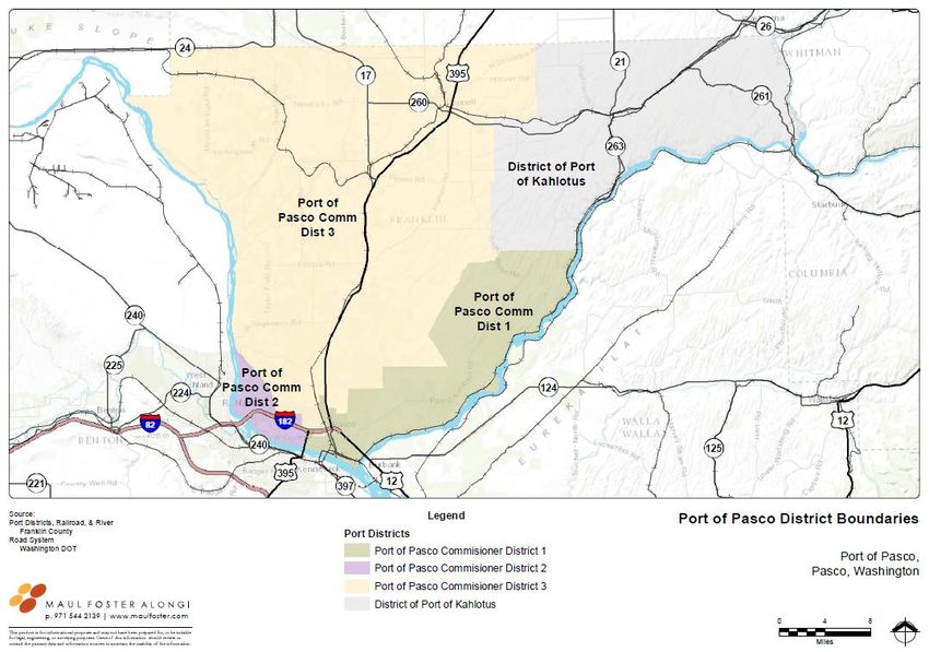
DRAFT JULY 2021

FIGURES & TABLES
    FIGURES
       2.1 THE PORT OF PASCO IN WASHINGTON                                                              3
       2.2 PORT OF PASCO DISTRICT BOUNDARIES                                                            4
       3.1 DEVELOPMENT AREAS                                                                            7
       4.1 TRI-CITIES AIRPORT, AIRPORT INDUSTRIAL PARK, AND AIRPORT BUSINESS CENTER                     9
       4.2 AIRPORT INDUSTRIAL PARK                                                                 11
       4.3 AIRPORT BUSINESS CENTER                                                                 12
       4.4 PASCO PROCESSING CENTER                                                                 14
       4.5 BIG PASCO INDUSTRIAL CENTER AND BARGE TERMINAL                                          17
       4.6 OSPREY POINTE                                                                           21
       4.7 THE WHARF PROPERTY                                                                      24
       4.8 REIMANN INDUSTRIAL CENTER                                                               26
       4.9 PASCO INDUSTRIAL CENTER 395                                                             29
       4.10 HERITAGE RAIL SPUR                                                                     32

    TABLES
       3.1 AGGREGATE ACREAGE OF DEVELOPMENT AREAS BY FUNCTIONAL CLASSIFICATION                          6
       3.2 FUNCTIONAL CLASSIFICATION OF DEVELOPMENT AREAS                                               8

PORT OF PASCO COMPREHENSIVE SCHEME OF HARBOR IMPROVEMENTS—Draft                             PAGE   ii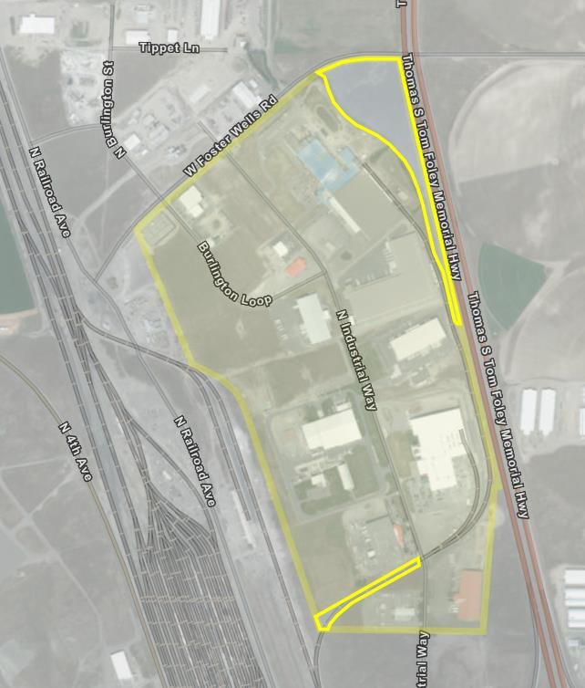
DRAFT, JULY 2021

                                                                                                             1. INTRODUCTION

PURPOSE OF COMPREHENSIVE SCHEME OF                                         PUBLIC INVOLVEMENT
HARBOR IMPROVEMENTS                                                        Ports are required to conduct a public hearing prior to adoption of a
Washington ports are required by state law to develop a                    CSHI. Notice of the hearing must be published once a week for two
Comprehensive Scheme of Harbor Improvements (CSHI) (Revised                consecutive weeks in a newspaper of general circulation in the port
Code of Washington [RCW] Chapters 53.20). The purpose of a CSHI            district at least ten days prior to the hearing date (RCW 53.20.010 and
is to openly inform port district residents of the nature and extent of    53.20.020). Future improvements are required to be made in
Port development and anticipated improvements. By law, a CSHI must         substantial accordance with the CSHI unless or until such plans have
be developed and approved prior to expenditure of port funds for           been officially changed by the port commission following a public
improvements supporting property development. Other items such as          hearing.
necessary salaries and clerical and office expenses, as well as the cost
of engineering, surveying, preparation, and collection of data necessary    The Port conducted a public hearing on September 9, 2021 and
for the creation and adoption of the CSHI, are exempt.                      published the notice on the dates of August 26, 2021 and
                                                                            September 2, 2021 in the Tri-City Herald.
The term “scheme” generally connotes a conceptual plan rather than
a detailed analysis. CSHIs need not include detailed construction plans.
CSHIs are also differentiated from strategic plans, which often derive
from a financial perspective and are policy-driven.                        PUBLIC HEARING COMMENTS

     CSHIs must include:                                                         •   Comments received through the public hearing process
                                                                                     will be incorporated into the final revision of this
        • Map of port-owned lands                                                    document.
        • General statement of objectives
        • Inventory and description of existing port facilities
                                                                           CONSISTENCY WITH OTHER PLANS
        • General description of planned improvements
                                                                           The Port of Pasco (the Port) approved its first CSHI in 1940
                                                                           (Resolution No. 6). And periodically amended its CSHI to
                                                                           accommodate changing conditions and opportunities. The last

PORT OF PASCO COMPREHENSIVE SCHEME OF HARBOR IMPROVEMENTS—Draft                                                                           PAGE   1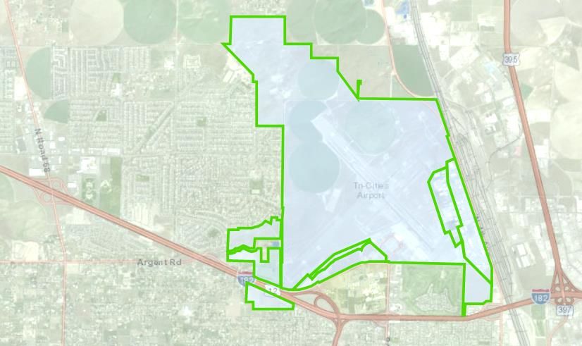
DRAFT JULY 2021

Comprehensive plan update was approved in September 2020. This             •   Port of Pasco Capital Improvement Plan (CIP): The annual
CSHI supersedes past revisions, incorporates the most recent Tri-              CIP is a specific list of capital projects intended to be
Cities Airport Master Plan, and is consistent with the City’s and              accomplished over the next 3 years. Projects may be added,
County’s Comprehensive land use plan.                                          removed, or modified to meet specific business conditions as
Other plans prepared by the Port which are related to, but not a part          deemed warranted by the Port. The projects listed in the CIP
of the CSHI, include:                                                          comply with the general development improvements set forth
                                                                               in the CSHI.
   •   Port of Pasco Strategic Plan: The Strategic Plan is used to
       define the Port’s overall mission, values, and planned              •   Tri-Cities Airport Master Plan: The Airport Master Plan is
       strategies. Its primary purpose is to set the strategic direction       an FAA required document for all airports. The plan is
       and goals for the Port and staff rather than focusing on                updated approximately every 6-10 years and governs
       specific property development plans.                                    development at the Tri-Cities Airport per FAA regulations.

PORT OF PASCO COMPREHENSIVE SCHEME OF HARBOR IMPROVEMENTS—Draft                                                                     PAGE   2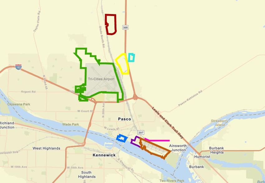
DRAFT JULY 2021

                                                                                             •       2. PORT BACKGROUND
                                                                           In 1963, the Port assumed ownership and operational responsibility
PORT HISTORY                                                               for the former World War II U.S. Navy facility, known as the Pasco
                                                                           Airport, from the City of Pasco, and renamed it the Tri-Cities Airport
The Port is a special purpose district municipal corporation established
                                                                           (PSC). Over the years, the Port has made major improvements,
by the voters of Franklin County in 1940. The Port’s jurisdictional
                                                                           including new runways, safety clearance areas, aviation navigational
boundaries are not coterminous with the county’s boundary, but
                                                                           systems, parking, and new passenger terminal facilities, transitioning
include approximately two-thirds of the county.
                                                                           the original military installation into a key regional transportation
Figure 2.1 The Port of Pasco in Washington                                 facility.
                                                                           In total, the Port now provides facilities at PSC, the BPIC and Barge
                                                                           Terminal, the Pasco Processing Center (PPC), The Wharf property,
                                                                           The Reimann Industrial Center (RIC), the Pasco Industrial Center 395
                                                                           (PIC395), and the Heritage Railspur totaling assets worth in excess of
                                                                           $160 million. The Port provides major transportation facilities and
                                                                           industrial real estate, making it a critical component of the regional
                                                                           economy.

                                                                             The Port originally owned and developed what has become
                                                                                 the Pasco Processing Center, creating 1,500 jobs.

That same year, the Port Commission adopted Resolution No. 6,              The area’s geographic location makes the Port a transportation hub for
approving the Port’s first CSHI. The Port was originally formed to         the entire Pacific Northwest. There is highway access to all the facilities
provide facilities supporting shipment of regionally produced grain via    via Interstate 182, U.S. Route 395, and U.S. Route 12. Mainline railroad
barge on the Columbia River to seacoast terminals.                         service is provided by BNSF, which operates a major switchyard in
                                                                           Pasco. Air transportation, for both passengers and cargo, is available
In 1959, with 94 percent voter approval, the Port purchased a World        at the Tri-Cities Airport. Barge shipments, bulk and in containers, is
War II army depot, now known as Big Pasco Industrial Center (BPIC).        available within port facilities at the largest public marine terminal on
The Port installed the first container crane facility on the upper         the upper Columbia River.
Columbia River for barging products to and from Pasco. The Barge
Terminal has averaged over 2,700 containers per year, with most of the     The Port continues to consider strategic acquisition of properties, and
containers used in exporting local products.                               construct buildings and infrastructure that support furthering of the
                                                                           regional economy. The Port has issued low-interest General

PORT OF PASCO COMPREHENSIVE SCHEME OF HARBOR IMPROVEMENTS—Draft                                                                              PAGE   3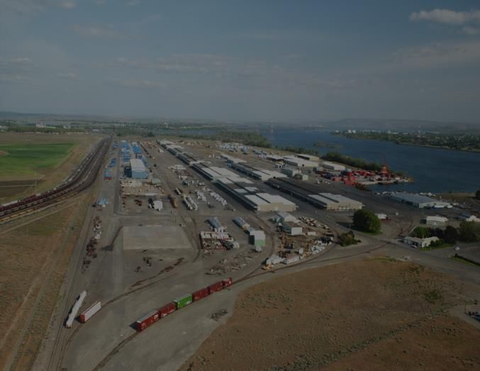
DRAFT JULY 2021

Obligation Bonds and Revenue Bonds for development of its                     Figure 2.2 Port of Pasco District Boundaries
industrial lands and facilities, providing both taxable and tax-exempt
interest to bond purchasers while funding significant public
investment.

PORT GOVERNANCE
The Port is governed by a three-member, nonpartisan board of
commissioners. Commissioner six-year terms are staggered so that
only one position is up for election every two years. The Port
jurisdiction is subdivided into commissioner districts in the western
portion of Franklin County, while east Franklin County is served by
the Port of Kahlotus (Figure 2.2).
The Commission appoints an executive director, who serves as the
managing official of the Port responsible for the administration and
day-to-day operations of the Port. The Commission delegates its
authority to the executive director through a delegation of authority
policy. The Port Commission also appoints the Port’s legal counsel and
auditor, pursuant to state statutes. The executive director is responsible
for retaining and managing all other Port staff.                             MISSION STATEMENT
The commissioners of the Port at the time of the 2021 CSHI adoption          The Port of Pasco strategically allocates Port resources and
are:                                                                         transportation assets to attract and support sustainable jobs and a
                                                                             healthy tax base in greater Franklin County.
      •   Vicki Gordon, Port District 1
      •   Jean Ryckman, Port District 2                                      PORT VALUES
      •   Jim Klindworth, Port District 3
                                                                             The Port’s values define the beliefs and ideals that the Port subscribes
                                                                             to as it delivers on its mission, in essence “how” the Port does its work.
                                                                                             •   The Port values maintaining a livable community
                                                                                                 with a unique sense of place that is attractive to
                                                                                                 businesses and working families while balancing
                                                                                                 the need for financial viability.

PORT OF PASCO COMPREHENSIVE SCHEME OF HARBOR IMPROVEMENTS—Draft                                                                               PAGE   4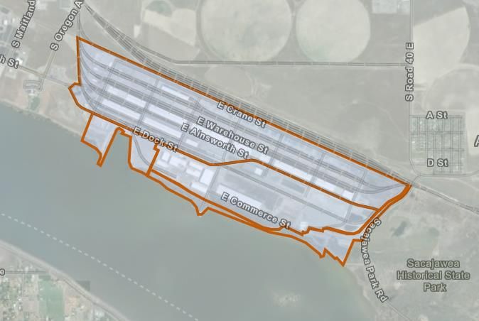
DRAFT JULY 2021

              •   The Port appreciates the contributions that              GUIDING PURPOSES
                  travelers using the Tri-Cities Airport make to the
                  region, as well as all the visitors and customers at     This overarching guidance directs the course of the Port of Pasco as it
                  other Port facilities.                                   fulfills its mission and defines, in general terms, what it aspires to
                                                                           accomplish throughout the medium- and long-term horizons.
              •   The Port places a special emphasis on supporting
                  its tenants to improve their chances of success and      1. Ensure a healthy and growing local economy through family wage
                  growth.                                                     job growth and sustainable local taxes to support community
                                                                              services.
              •   The Port takes its unique community role and
                  public trust responsibilities seriously and pledges to   2. Increase earned revenues (non-tax base) utilizing a threshold rate
                  work in an open and decisive manner, coordinating           of return standard on invested capital as a “means” to achieving
                  with other governmental jurisdictions and valuing           desired “ends.”
                  constructive community, tenant, customer and             3. Maintain and improve essential transportation facilities and
                  employee input in its deliberations.                        services to support the local economy today and into the future,
              •   The Port places a premium on retaining high                 and to service Port-owned properties.
                  quality staff to execute the Port’s programs and         4. Weigh financial risk against return on investment (ROI), job
                  manage its facilities.                                      creation and retention, and the prioritization of resource
              •   The Port demonstrates leadership in community,              allocation.
                  state, and national issues to further advance the        5. Provide a platform for a stable and growing portfolio of tenants
                  economic prosperity of Franklin County and the              through investment in infrastructure and industrial facilities.
                  region.
                                                                           6. Foster business retention by meeting with and assisting key
              •   The Port operates and maintains safe and                    employers within the Port District. Nurture existing small
                  environmentally conscious facilities that are well          businesses.
                  maintained to protect the community’s                    7. Attract new business to the County by meeting needs not
                  investment(s).                                              addressed by the private sector. Incentivize business and
              •   The Port values its relationship with its vendors           development.
                  and suppliers.                                           8. Leverage resources with public agency partners and private
                                                                              investors that advance the Port’s commitment to the greater
                                                                              community.
                                                                           9. Invest in public and community amenities if they complement
                                                                              economic development efforts or enhance Port-owned properties.

PORT OF PASCO COMPREHENSIVE SCHEME OF HARBOR IMPROVEMENTS—Draft                                                                           PAGE   5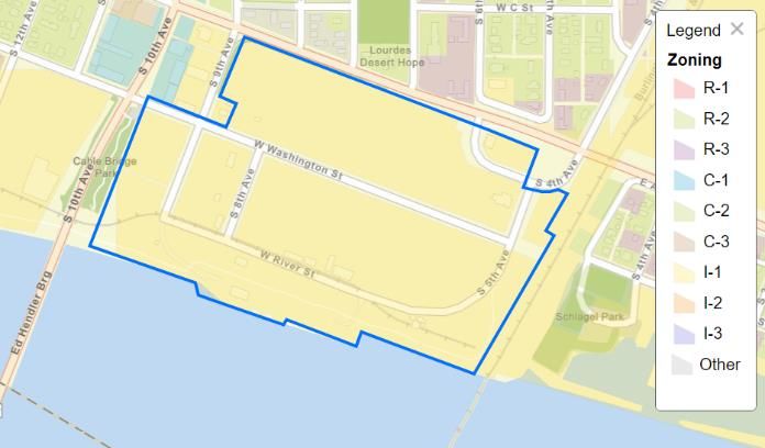
DRAFT JULY 2021

                                                                                            3. REAL ESTATE OVERVIEW
Port-owned real estate plays a critical role in incentivizing local        broken into planning areas when specific investments are phased or
business development and job creation. The Port’s real estate program      serve distinct purposes.
is intended to stimulate private investment in the local economy, grow     This section provides a summary of the acreage of Port property in the
new economic activity, and create employment opportunities. In some        development areas by functional classification (i.e., primary use).
cases, Port-led redevelopment assists in revitalizing underutilized        Section 4, Development Areas, includes the following details:
properties and blighted neighborhoods, improving the quality of life in
                                                                                           •   Location Definition
the Pasco area and greater Franklin County.
                                                                                           •   General Description
The real estate portfolio increases earned revenues, which minimizes
the reliance on taxes while fueling the Port’s economic development                        •   Real Estate Goals and Intended Use
programs. To supplement its investment, the Port leverages its                             •   Existing Improvements
resources in partnership with other public agency partners and private
investors to maximize public benefit.                                                      •   Description of Utilities

The Port seeks opportunities that fill real estate service and product                     •   Planning Area Description
gaps not otherwise provided by the private market.
                                                                           Table 3.1—Aggregate Acreage of Development Areas by Functional
                                                                                     Classification
PORT-OWNED PROPERTIES
                                                                              Function                                        Acreage
The Port currently owns or is in the process of purchasing/selling
                                                                              Airport Operations                              1,928.8
approximately 3,500 acres. These properties, together with other
strategic properties not under current Port ownership, are presented          Runway-Dependent Property                       79.6
based on geographic and current or planned land uses as seven                 Barge Operations                                28.9
separate land groups, referred to as development areas. Figure 3.1 shows
the locations of the Port’s seven development areas Development               Industrial                                      909.2
areas are places where the Port plans to conduct on-going business and        Mixed Use Commercial/Office/Residential         185.6
development including property acquisition, construction,                     Recreation / Open Space                         205.7
infrastructure improvements, and leasing.
                                                                                           TOTAL ACREAGE                      3,282.8
Development areas may consist of several contiguous parcels. The
concept of a development area is land that is planned for in the
aggregate, in development phases. Some development areas are further

PORT OF PASCO COMPREHENSIVE SCHEME OF HARBOR IMPROVEMENTS—Draft                                                                            PAGE   6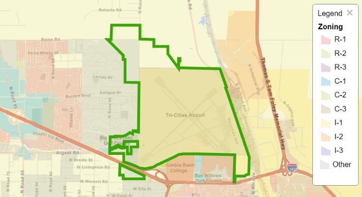
DRAFT JULY 2021

Figure 3.1 Development Areas

                                                                                              Connell
                                                Reimann
                                                Industrial
                                                  Center

                                                                         Pasco
                                                                       Industrial               Pasco
                                                                      Center 395

                                                                            Pasco
                                                                          Processing
                                   Tri-Cities
                                    Airport                                 Center

                                                                   The
                                                                  Wharf           Heritage
                                                                                  Rail Spur

                                                                     Osprey
                                                                     Pointe
                                                                               Big Pasco
                                                                               Industrial
                                                                                 Center

PORT OF PASCO COMPREHENSIVE SCHEME OF HARBOR IMPROVEMENTS—Draft                                               PAGE   7
DRAFT JULY 2021
Table 3.2 Functional Classification of Development Areas
Development Area Planning Area Sub-Area Function Acreage
1 Tri-Cities Airport, Airport 1. Airport Operations Airport Operations 1,928.8
Industrial Park & Airport
2a. Airport Industrial Park Runway-Dependent Uses 60.8
Business Center
2b. Airport Industrial Park Industrial 169.4
3a. Airport Business Center Runway-Dependent Uses 18.8
3b. Airport Business Center Commercial 71.5
4. Buffer Area Recreation/Open Space 136.1
TOTAL 2,365.0
2 Pasco Processing Center 1. PPC Remaining Property Industrial 16.7
TOTAL 16.7
3 Big Pasco Industrial 1. Retention Area Industrial 226.7
Center 2. Expansion Area Industrial 109.1
3. Barge Terminal Barge Operations 28.9
4. Open Space Recreation/Open Space 57.8
TOTAL 422.5
4 Osprey Pointe 1. Osprey Pointe North Industrial 34.5
2. Osprey Pointe Waterfront Waterfront Mixed Use 55.3
3. Open Space Recreation/Open Space 11.8
TOTAL 101.6
5 The Wharf Mixed Use 58.8
TOTAL 58.8
6 Reimann Industrial Center Industrial 297.8
TOTAL 297.8
7 Pasco Industrial Center Industrial 555.0
395
TOTAL 55.0
PORT OF PASCO COMPREHENSIVE SCHEME OF HARBOR IMPROVEMENTS—Draft PAGE 8DRAFT, JULY 2021
4. DEVELOPMENT AREAS
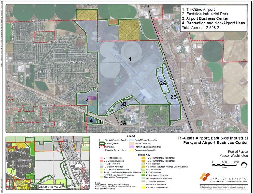
TRI-CITIES AIRPORT, AIRPORT BUSINESS CENTER, AND EASTSIDE INDUSTRIAL CENTER
Figure 4.1 Tri-Cities Airport, Airport Industrial Park, and Airport Business Center
PORT OF PASCO COMPREHENSIVE SCHEME OF HARBOR IMPROVEMENTS—Draft PAGE 9DRAFT, JULY 2021
Legend
Port Development Areas
1. Airport Operations
2. Eastside Industrial Park
3. Airport Business Center
4. Buffer Area
Total Acres = 2365.0
4
PORT OF PASCO COMPREHENSIVE SCHEME OF HARBOR IMPROVEMENTS—Draft PAGE 10DRAFT JULY 2021
The intent for Tri-Cities Airport Development Area is to provide the
necessary facilities supporting commercial and general aviation,
general light industrial use, as well as airport-dependent and airport- GENERAL DESCRIPTION
related business. Most of the property in the development area is
regulated by the Federal Aviation Administration (FAA) and must Built in 1942 by the US Navy on the former Franklin County Airport
remain in Port ownership. site, the Tri-Cities Airport (PSC) began providing commercial air service
CURRENT CONDITIONS in the late 1940s. The Port acquired ownership of PSC in 1963 and has
since managed airport operations and guided its growth. PSC is
Port Parcels: 116340143, 116330033, 116530022, 116570015, designated as a Primary Commercial Service Non-Hub Airport by the
113120024, 117010010, 113290029 (part), 117301018, FAA National Plan of Integrated Airport Systems.
117310017, 117322031, 117322040, 119012078,
19180011, 119222029, 119012078, 114310013 In 2019, PSC accommodated 437,000 total passenger enplanements, the
third highest in the state of Washington. PSC also supports air cargo
Jurisdiction: Primarily City of Pasco. However, some buffer area and general aviation operations, and has over 150 acres of commercial
parcels to the north are located in unincorporated and industrial property within the development area.
Franklin County.
Consistent with FAA requirements, the Port regularly updates a detailed
Size: 2,365.0 acres. Airport Master Plan, which guides airport operations and planned
Utilization: Commercial and general aviation, light industrial, improvements. This was last approved by the Port Commission in 2012
agricultural-related production, recreation, and and is adopted in its entirety by reference into this CSHI. A new master
commercial business parks. plan is expected later in 2020.
Current Use: Airport Operation, Runway-Dependent Uses,
EXISTING IMPROVEMENTS
Industrial, Commercial, Ag Production Recreation,
Open Space. • Three runways: two for commercial, cargo, and military use; one
for general aviation aircraft.
Zoning: Mostly Light Industrial (I-1). Also includes: Medium
Industrial (I-2), Residential Transition (RT), Suburban • Four aircraft aprons: a terminal apron used for commercial
(RS-12), and Suburban/Planned Unit Residential (R- aircraft parking, the northwest apron for transient aircraft,
S-1/PUD); County AP-20. There are also “Airport FedEx’s cargo aircraft apron, and one general aviation apron.
Overlay Zones” in both the City and County adding • Two-story terminal building with five interior gates, constructed
additional land use restrictions to protect airport in 1966 and expanded in 1986 and 2016.
operations.
• Short- and long-term parking lots, employee parking lot, and
Comp. Plan: Majority designated Industrial, with remaining parcels rental parking lots. Parking stalls total 1,589 standard parking
designated as Parks/Open Space and Public/Quasi- stalls, including 26 handicapped spaces.
Public.
PORT OF PASCO COMPREHENSIVE SCHEME OF HARBOR IMPROVEMENTS—Draft PAGE 11DRAFT JULY 2021
• Airport Traffic Control Tower uses an airport surveillance radar PSC is composed primarily of an airfield and passenger terminal.
system to track and manage aircraft. Property in the planning area is classified as either airside or landside.
Airside functions facilitate aircraft movement and storage.
• FedEx facilities include parking and ramp space for two aircraft.
Improvements include runways, taxiways, aprons, and tie-downs for
• Two Fixed Based Operator facilities serving the general aviation general aviation planes. Landside areas include the passenger terminal
community. building, the airport traffic control tower, automobile access, and
• Approximately 50 buildings for airport-dependent, airport- parking. Most of this planning area is zoned I-1; however, as shown in
related, and non-airport-related business in the Airport Figure 4.1, parts of this area north of the main airport are zoned for I-
Industrial Park. 2, RT, R-S-1/PUD, and agricultural production (AP-20). Development
• Four buildings for airport-dependent uses exist in the ABC. in this area is intended to be airport-compatible uses such as agriculture
production or aviation-related industry.
PLANNING AREAS Intended improvements to this area include:
This development area has four planning areas:
• Extending and/or relocating runways
1. Operations Area • Realigning and/or building new taxiways
2. Airport Industrial Park
• Updating the Terminal Building
3. Airport Business Center (ABC)
• Expanding aprons to accommodate development
4. Buffer Area
• Expanding parking facilities
UTILITIES • Updating lighting
• Other improvements as required to support commercial airport
• Tri-Cities Airport: Most sewer and water infrastructure is
owned and maintained by the Port.
2. AIRPORT INDUSTRIAL PARK
• Airport Industrial Park: Existing sewer and water infrastructure
Figure 4.2 Airport Industrial Park
is owned and maintained by the City of Pasco. Roads are owned
and maintained by the Port. The Airport Industrial Park is a 230-acre
2A site east of the airport terminal that
• ABC: The Port will complete the road and utilities
includes 500,000 square feet of building
improvements (now only partially complete) in conjunction
2B space and is used for light industrial,
with a binding site plan or lease master plan then turn facilities
A airport-dependent, and airport-related
over to the City of Pasco
businesses. The western half of the
planning area is considered airport-
1. OPERATIONS AREA
dependent in that it will be reserved for
airport-related functions (see Figure 4.2, Area 2A). East of Stearman
PORT OF PASCO COMPREHENSIVE SCHEME OF HARBOR IMPROVEMENTS—Draft PAGE 12DRAFT JULY 2021
Road (Area 2B), the property is planned for largely industrial uses, such The remaining 56 acres in Area 3B to the south are intended for light
as agricultural, small business warehouse/manufacturing companies, industrial and non-airport-related industrial and commercial
and local government support shops. Current tenants include Apollo, development that serves the surrounding businesses and residents, and
Franklin County Public Works and Planning, Pasco School District businesses catering to the traveling public such as hotels, restaurants,
operations, agricultural users, and various small private businesses (e.g., and service stations. Area 3B’s 22 parcels range in size from about one-
contracting). third of an acre to 5.36 acres. All of the Airport Business Center parcels
are zoned I-1 and are for lease only.
Intended improvements to this area include:
The Port constructed utilities at both ends of this area and intends to
• Expansion of the East General Aviation Apron complete the infrastructure through the Area as demand warrants.
• Building renovations Intended improvements to this area include:
• Infrastructure improvements
• New light industrial buildings • Completion of a binding site plan or master plan
• Completion of site roads and utilities with dedication to City
3. AIRPORT BUSINESS CENTER • Signage
Figure 4.3 Airport Business Center • Landscaping
• Port or Tenant buildings (as necessary)
• Other improvements as required to support business park
4. BUFFER AREA
3A
3a The Buffer Area is land intended to protect the integrity of the airport
3b3B operations and serve as a residential buffer. The planning area is zoned
by the City of Pasco as RT north of West Argent Place and zoned RS-
12 to the south.
Some of this land is available for recreational activities or low intensity
commercial activities upon specific Port approval and is leased by the
Port. Pasco Golfland, a nine-hole golf course, soccer fields, and a trail
The 90-acre ABC is situated near the airport and has been developed walking area are currently located within the buffer area, to the north of
for higher-end commercial businesses. Approximately 30 acres along West Argent Road in the southeast corner of the planning area. South
the northern edge of this planning area are airport-dependent in that of I-182 is a vineyard.
they are reserved for airport-related functions (see Area 3A in Figure
4.3). Area 3A will be divided into 21 parcels that are 0.5 to 1 acre in size.
PORT OF PASCO COMPREHENSIVE SCHEME OF HARBOR IMPROVEMENTS—Draft PAGE 13DRAFT, JULY 2021
PASCO PROCESSING CENTER AND FOSTER WELLS BUSINESS PARK
Figure 4.4 Pasco Processing Center and Foster Wells Business Park
Legend
Port Development Areas
Previously Developed Areas
1
1. REMAINING PORT PROPERTY OF PPC
Total Acres = 16.7
1
PORT OF PASCO COMPREHENSIVE SCHEME OF HARBOR IMPROVEMENTS—Draft PAGE 14DRAFT JULY 2021
The Pasco Processing Center (PPC) Development Area initially facilitate park development. The Port assisted with permitting to
included all of the shaded areas shown in Figure 4.4. PPC was allow for expedited plant construction. The remaining developable
developed by the Port for large-scale food processing users and parcels of the Pasco Processing Center were sold to private entities
support businesses and currently supports 1,600 jobs. All of the in January 2014.
PPC, except Planning Area 1, has been sold to private owners. The
northwest corner of smaller lots was known as the Foster Wells The Port has also now fully developed the adjacent Foster Wells
Business Park which has also been sold to private owners. Business Park, which focused on light and medium industrial uses
that benefit from its close proximity to large agricultural uses.
CURRENT CONDITIONS These sites were sold for manufacturing, warehousing,
distribution, and other light industrial uses that may or may not be
Port Parcels: 113120368, 113120570, 113120577, 113120578, tied to agricultural use. The remaining parcels of the Foster Wells
113120579, 113120582, 113120583, 113120584,
Business Park were sold in 2020.
113120585, 113120586, 113120575, 113120576,
113130041, 113130494.
EXISTING IMPROVEMENTS
Jurisdiction: City of Pasco.
• A 250-acre development
Size: 16.7 acres under current ownership.
• 20 building sites of various sizes
Utilization: Industrial Uses, Food Processing, Support
• Nearby access to rail, barge, highway, and air
Businesses.
Current Use: Former port-owned parcels are used for light and
medium industrial; manufacturing and
UTILITIES
warehousing; agricultural uses. 2 Port-owned The PPC is served by an process water reuse system that is city-
properties remain vacant. owned, -operated, and -permitted. Potable water and sanitary
Zoning: I-1 (privately owned parcels), I-2 (Port-owned sewer utilities are also city-owned and -operated. The Port built
parcels). Industrial Way and Burlington Loop Road and associated utilities,
and transferred ownership to the city. In addition, the area is
Comp. Plan: Industrial. served by Cascade Natural Gas, Franklin PUD, and Century Link
telecom.
GENERAL DESCRIPTION
The Pasco Processing Center is an industrial area dedicated to
large-scale food processing uses and support buinesses located
along U.S. Route 395. The Port established the park and
constructed sewer, water, natural gas infrastructure, and roads to
PORT OF PASCO COMPREHENSIVE SCHEME OF HARBOR IMPROVEMENTS—Draft PAGE 15DRAFT JULY 2021
1. REMAINING PORT PROPERTY OF PPC
The Port intends to maintain ownership of Planning Area 1 for
possible future development of an interchange on U.S. Route 395,
at which time it would be sold. If an interchange is not built, the
site could also be used for industrial or highway related commercial
use. The site is zoned I-2.
A small portion of Planning Area 1 is right-of-way for the Port
owned railroad serving industry at the PPC. The Port will retain
ownership of this right-of-way and the railroad spur to serve
current customers.
Intended improvements to this area could include:
• Highway interchange
• Non-speculative construction of buildings
• Fencing and landscaping
• Utility extensions
• Rail maintenance and upgrades
• Other improvements as needed to support industrial or
commercial development
PORT OF PASCO COMPREHENSIVE SCHEME OF HARBOR IMPROVEMENTS—Draft
PAGE 16DRAFT JULY 2021
BIG PASCO INDUSTRIAL CENTER
Figure 4.5 Big Pasco Industrial Center
1. Retention Area
2. Expansion Area
3. Barge Terminal
4. Open Space
Total Acres = 419.0
Legend
Port Development Areas
1
3
2
4
PORT OF PASCO COMPREHENSIVE SCHEME OF HARBOR IMPROVEMENTS—Draft PAGE 17DRAFT, JULY 2021
The Big Pasco Industrial Center (BPIC) is intended for businesses agreement with the City of Pasco. The Plan includes almost 46 acres
interested in leasing low-cost and low-visibility warehousing, outdoor of new buildings and developable land for diverse industrial and
storage, and land-consumptive production areas. The Port intends to speculative development, possible commercial, as well as build-to-suit
maintain its ongoing industrial facilities and activities in this area and arrangements.
does not intend to make any significant changes to its shoreline at this The Barge Terminal is a 29-acre, multi-modal facility adjacent to the
time. Additional river freight handling facilities may be developed in Columbia River. The terminal is a limited-service
the future. The Port is authorized to develop, lease, or sell all or container/barge/bulk facility and has storage capacity for over 1,000
portions of the land and/or facilities in the BPIC to further industrial containers and chassis. The terminal has access to downriver ports,
development, and the Port Commission is authorized to execute any rail on dock, and major highway systems.
and all documents needed for such purposes.
EXISTING IMPROVEMENTS
CURRENT CONDITIONS
Big Pasco Facilities:
Port Parcels: 112420028; 112420029
• 419 acres, including barge terminal
Jurisdiction: City of Pasco
• Rail and truck connectivity
Size: 419 acres
• Barge/water access
Utilization: Big Pasco—Manufacturing, warehousing,
industrial office, and distribution Barge Terminal Facilities:
• 25 acres, with 15 acres for storage
Barge Terminal—container storage and shipping,
refrigeration, bulk cargo handling • Refrigeration unit plugs for 24 containers
Current Use: Big Pasco—Industrial uses and outdoor storage of • 3-phase power
products and materials • On-dock rail
Barge Terminal—Maritime and rail use UTILITIES
Zoning: Heavy Industrial (I-3) Although the development area is connected to city sewer and water
Comp. Plan: Industrial systems, the sewer, water, and storm drainage systems internal to the
area are owned and operated by the Port (see Appendix B). In
addition, the area is served by Cascade Natural Gas, Franklin PUD,
GENERAL DESCRIPTION
and Century Link telecom.
The BPIC and Barge Terminal areas occupy 422 acres along the
Columbia River. This is one of the few areas zoned for I-3 uses in the PLANNING AREAS
greater Pasco area. BPIC is intended for manufacturing, warehousing,
transloading, industrial office, and distribution. Planned development 1. Big Pasco Retention Area (BPRA)
within BPIC has been preapproved as part of a 2009 development 2. Big Pasco Expansion Area (BPEA)
PORT OF PASCO COMPREHENSIVE SCHEME OF HARBOR IMPROVEMENTS—Draft PAGE 18DRAFT JULY 2021
3. Barge Terminal developed beyond this range to suit the needs of the business tenants.
4. Open Space It is anticipated that buildings in this area will include industrial
manufacturing space, warehouse storage of materials and products,
1. BIG PASCO RETENTION AREA distribution, and have truck courts capable of serving a trailer up to
53 feet long.
The BPRA contains approximately 240 acres of I-3–zoned property.
The area includes eight World War II-era warehouses, each Intended improvements to this area include:
approximately 173,000 square feet in size (total building capacity of • Non-speculative construction of buildings
1,252,800 square feet not including 3 bays that have been • Fencing and landscaping
demolished). The area also includes a number of smaller industrial
• Roads, rail, and utilities
buildings and outdoor storage activities. The BPRA is located in close
proximity and has easy access to highway, rail, and river barge modes • Other improvements as needed to support industrial park
of transportation.
3. BARGE TERMINAL
Intended improvements to this area include:
The existing multi-modal Barge Terminal encompasses approximately
• Existing building maintenance and upgrades 25 acres of land located between the BPEA and the Osprey Pointe
• Sewer and water system upgrades, as needed Development Area. The intent of this facility is to transport products
• Rail facilities upgrades from the terminal to downstream destinations along the river. The
• Road upgrades capacity of the existing docking facility along the Barge Terminal
• Other improvements as needed to support industrial park could double in size by improving the west side of the slip. This area
could also be used for office or industrial expansion to take advantage
of the waterfront location. The barge terminal has easy access to
2. BIG PASCO EXPANSION AREA
major highway systems, BNSF mainline service to Tacoma, Portland
The I-3–zoned BPEA is located south of Dock Street and East and Seattle, and barge service to Portland, Oregon. A large portion
Ainsworth Avenue between the existing barge slip and Sacajawea Park of the barge slip is currently leased to a bulk wood chip importer.
Road. This area encompasses approximately 155 acres of waterfront
property in the eastern portion of the BPIC’s shoreline and is To facilitate the Barge Terminal’s operations, the existing shoreline in
intended for large-scale industrial and open storage uses. There is also the Barge Terminal area has been protected by 1,000 linear feet of
a 20,000-square-foot office building. A large section of the BPEA is concrete wharf structures and rock armoring and is devoid of
under long-term lease to an agricultural manufacturer. vegetation. The Port intends to maintain its ongoing industrial
facilities and activities in the Barge Terminal and does not intend to
The 2009 BPIC development agreement indicates several large make any significant changes to its shoreline.
development blocks in this BPEA. It is anticipated that a total
maximum of two million square feet of industrial and/or warehouse Intended improvements to this area include:
building space will be created in the future. The seven new
industrial/warehouse buildings are expected to range from 100,000 to • Improvements as needed to support barge terminal
600,000 square feet of building floor area each. Buildings may be • Improvements to docks in the barge slip
PORT OF PASCO COMPREHENSIVE SCHEME OF HARBOR IMPROVEMENTS—Draft PAGE 19DRAFT JULY 2021
• Improvements to existing buildings
• Roads and utilities
4. OPEN SPACE
This open space area includes land along the riverfront shoreline and
landscape buffer setbacks from adjacent streets and neighboring
properties. The Port plans to remove nonnative vegetation and
replace it with plants native to this riverine environment or with other,
ornamental varieties. Portions of the area may be converted to
industrial use in the future as needed.
Intended improvements to this area include:
• Erosion-control measures
• Maintenance of Sacajawea Heritage Trail
• Landscaping and public amenities
PORT OF PASCO COMPREHENSIVE SCHEME OF HARBOR IMPROVEMENTS—Draft PAGE 20DRAFT, JULY 2021
OSPREY POINTE
Figure 4.6 Osprey Pointe
1. Osprey Pointe North
2. Osprey Pointe Waterfront
3. Open Space
Total Acres – 92.8
Legend
Port Development Areas
USA Ownership
1
1
2
3 2
Zoning Map
PORT OF PASCO COMPREHENSIVE SCHEME OF HARBOR IMPROVEMENTS—Draft PAGE 21DRAFT JULY 2021
Osprey Pointe is being developed as a waterfront mixed use Utilization: Industrial, office, and public waterfront
development and a public waterfront destination. The Port is Current Use: Office space, public recreation, municipal services
authorized to develop, lease, or sell all or portions of the land and/or
facilities at Osprey Pointe to further economic development, and the Zoning: I-1 and I-3
Port Commission is authorized to execute any and all documents Comp. Plan: Industrial
needed for such purposes. Initial master planning for the 102-acre
development resulted in the initial phase of development which GENERAL DESCRIPTION
included the construction of a 20,000-square-foot office building and
Osprey Pointe is a unique blend of high-end office space, commercial
associated parking to serve as a catalyst for future development.
space, open space, light industrial, and public waterfront trails. Its
In 2019, The Port Commission passed Resolution 1523 promoting location on the Columbia River and absence of a levee provides for
economic development through mixed use development at Osprey ground level waterfront views and access to the river. The waterfront
Pointe. The term “mixed use” refers to developing property with a area south of Ainsworth Ave is being developed as both a “Class A”
mix of uses to include office, retail, commercial and residential uses. mixed use center and a public waterfront destination. The mixed used
Osprey Point’s unique location along the Columbia River is uniquely
designation in Osprey Pointe may include commercial, retail, office,
suited for the next generation of workforce that seeks an
environment that allows for residential, business and retail all within and residential uses. North of Ainsworth Avenue will include light
walking distance. Mixed use development of the Waterfront industrial, commercial, and office space.
Properties will lead to talent (workforce) attraction and retention
promoting economic development UTILITIES
Osprey Pointe has the capacity for nearly 1,000,000 square feet of new Site utilities are owned and maintained by the Port, but are
space in multi-story buildings. The property is currently zoned I-1 and connected to City systems.
I-3. The Port is working with the City to develop a new Waterfront
Zoning Code for the City which would be applied to Osprey Pointe. EXISTING IMPROVEMENTS
Waterfront Zoning would allow for office, professional, light ▪ Office building (20,000 square feet)
industrial, technological, residential, commercial and retail uses. ▪ Common parking lot and access way with approximately 110
stalls, including five handicapped-parking stalls supporting
CURRENT CONDITIONS the Office and Public area.
Port Parcels: 112420023, 112420024, 112420025, 112420026,
112420027, 112420029, 112353230, 112353231 ▪ Municipal services building (City Fire Department
headquarters and training facility; Franklin County
Jurisdiction: City of Pasco Emergency Management)
Size: 101.6 acres
PORT OF PASCO COMPREHENSIVE SCHEME OF HARBOR IMPROVEMENTS—Draft PAGE 22DRAFT JULY 2021
▪ Landscape park and open space with paved trail leading to retail, residential, or office purposes. Other allowed uses are for a
Sacajawea Park public market, hotel, and a regional entertainment venue. To spur
development, investment, and economic development, working with
a private master developer is encouraged. Buildings could be 7 stories
PLANNING AREAS or higher.
1. Industrial/Warehouse One of the attractions is the proximity to the Columbia River and the
2. Industrial Office/Flex associated panoramic views. As permitted under city shoreline
3. Mixed Use regulations, buildings can be constructed as close as 50 feet landward
4. Open Space of the designated high water line.
Intended improvements to this area include:
1. OSPREY POINTE NORTH
• Building construction
This planning area’s intended use is industrial/warehouse buildings • Utilities & other improvements for mixed use
that support light industrial manufacturing activities and
• New roads as needed
warehousing/distribution of materials and products, along with some
associated commercial activity and municipal services. The flex space • Public amenities and landscaping
is large, clear span industrial buildings for industrial manufacturing
space with integrated offices, covered storage, and small-scale 3. OPEN SPACE
warehouse space. Buildings may be one to two stories, and each may The open space area in Osprey Pointe includes land along the
be 10,000 to 50,000 square feet. Tracks for a rail spur could be riverfront shoreline and landscape buffers around the perimeter of
extended into this area as necessary to serve the needs of these the site adjacent to streets and neighboring properties. A significant
businesses. Oregon Avenue provides easy highway access to and greenway view corridor and open space are proposed to provide
from businesses that locate in this area. unobstructed views and public access to portions of the Columbia
Intended improvements to this area include: River from Oregon Avenue.
• Utilities and other improvements for industrial, warehouse, Intended improvements to this area include:
and flex space • Osprey Pointe Commons improvements
• Building construction • Kayak dock
• New roads as needed • Landscaping improvements
• Landscaping • Trail development and maintenance
2. OSPREY POINTE WATERFRONT
This planning area’s intended use is as a master planned waterfront
mixed use development. Buildings could be used for commercial,
PORT OF PASCO COMPREHENSIVE SCHEME OF HARBOR IMPROVEMENTS—Draft PAGE 23DRAFT, JULY 2021
THE WHARF PROPERTY
Figure 4.7 The Wharf Property
Legend
Development Areas
Total Acres 58.8
PORT OF PASCO COMPREHENSIVE SCHEME OF HARBOR IMPROVEMENTS—Draft PAGE 24DRAFT, JULY 2021
The Port is leading an effort to redevelop the The Wharf property due EXISTING IMPROVEMENTS
to the significant opportunity it presents for economic development
and transformation of the Pasco waterfront. A vision for the property • Existing road network
has been created that proposes mixed-use development incorporating • Barge mooring dock (currently unused)
light industrial, institutional, commercial, residential, and open space • River access
uses. However, redevelopment of a portion of the site is constrained • Light industrial buildings
by ongoing environmental cleanup actions and a regulatory restrictive • Pedestrian path (owned by the City of Pasco)
covenant. Efforts are currently under way to complete the cleanup to
allow for redevelopment. UTILITIES
CURRENT CONDITIONS • Water, sewer, and stormwater utilities are city-owned and
operated, and are located in the rights-of-way of Washington
Port Parcels: 112311016, 112312051, 112312042, 112312060, Street, River Street, South 5th Street, and South 9th Street.
112312079, 112312088, 112312097, 112312104,
112312131, 112312122, 112312024, 112312015, • A Pacific Power and Light substation is located in the eastern
112390137, 112390119, 112390084, 112390093, half of the property between Washington and River streets, but
112390075, 112390066, 112390057, 112390039, does not provide electricity to the site. On-site power is
provided by Franklin PUD.
112390011
Jurisdiction: City of Pasco PLANNING AREAS
Size: 58.8 acres The Wharf Development Area is comprised of one planning area. The
Utilization: Business park, mixed use, commercial, light Port plans to complete the environmental cleanup effort through
industrial, and open space monitored natural attenuation while investing in the property through
grants or private development. Most near-term improvements will be
Current Use: Light industrial; Vacant area undergoing cleanup focused on basic upgrades to the old industrial uses as funding is
Zoning: I-1 available.
Intended improvements to this area include:
Comp. Plan: Industrial
• Building construction and improvements
GENERAL DESCRIPTION • Utilities and other improvements for mixed-use development
The Wharf Development Area is a riverfront site that is currently • New roads as needed
undergoing environmental cleanup efforts over approximately 14 acres • Landscaping
or 25% of the property. The site is equipped with utilities and a road • Wood wharf rehabilitation
network, and fronts the Columbia River with a levee “berm”
separating landward property from a wood wharf and adjacent lands.
PORT OF PASCO COMPREHENSIVE SCHEME OF HARBOR IMPROVEMENTS—Draft PAGE 25DRAFT, JULY 2021
REIMANN INDUSTRIAL CENTER
Figure 4.8 Reimann Industrial Center
Legend
Development Areas
Total Acres 298
PORT OF PASCO COMPREHENSIVE SCHEME OF HARBOR IMPROVEMENTS—Draft PAGE 26DRAFT, JULY 2021
The Reimann Industrial Center (RIC) was acquired by the Port in 2019. with its partners at the City of Pasco, Franklin County, and Franklin
The property encompasses 298 acres as shown on Figure 4.9. The RIC PUD. The Port will prepare baseline permitting to allow for expedited
was purchased by the Port to attract large-scale food processing users, plant construction.
other large industrial users, and support businesses. The property is
currently undergoing master planning to determine the optimal lot The Port also plans to develop a portion of the RIC into smaller lots
layout and needed infrastructure. The property is currently being leased of 2-10 acres to focus on light and medium industrial uses that benefit
for agricultural production and for a cell tower lease as an interim use from its close proximity to large industrial uses. The uses would be
prior to industrial development. similar to those developed at the Foster Wells Business Park.
CURRENT CONDITIONS EXISTING IMPROVEMENTS
• A 298-acre property
Port Parcels: 124680039
• 2 developed ag circles with center pivots and well pumps
Jurisdiction: Franklin County (the southern portion is contained in
• Nearby access to rail, barge, highway, and air
a proposed City of Pasco UGA expansion which will
be considered by the County later in 2020).
UTILITIES
Size: 298 acres under current ownership.
Water: There is no municipal water at the site, however, there are 2
Utilization: Industrial Uses, Food Processing, Support Businesses. agricultural production wells which could possibly be used for potable
Current Use: Site is currently being used for ag production and a cell and/or industry use.
tower.
Sewer: No sewer facilities are present at the site.
Zoning: I-2.
Power: The Franklin PUD has power to a non-operating natural gas
Comp. Plan: Rural Industrial.
peaking plant along the west side of the property. There are no
distribution facilities or substation on site.
GENERAL DESCRIPTION
The Reimann Industrial Center is an industrial area dedicated to large- Natural Gas: Williams Companies and Cascade Natural Gas each have
scale food processing uses, other large industrial uses, and support high-pressure natural gas lines running across the site. There are no
businesses located between U.S. Route 395 and Railroad Avenue. The distribution facilities on site.
Port purchased the property in 2019 when the Pasco Processing
Center was fully developed. The property includes water rights of Rail: The BNSF operates rail lines adjacent to the site and has indicated
approximately 4 acre feet for 2 large irrigated farm circles on-site. they are willing to build a switch to serve the property.
The Port plans to install sewer, water, natural gas infrastructure, rail,
and roads to facilitate large-lot industrial development in cooperation
PORT OF PASCO COMPREHENSIVE SCHEME OF HARBOR IMPROVEMENTS—Draft PAGE 27DRAFT JULY 2021
PLANNING AREAS
1. LARGE LOT DEVELOPMENT
Approximately 2/3 of the site will be developed into large lots of 10
2. SMALLER LOT DEVELOPMENT
Approximately 1/3 of the site will be developed into smaller lots of
acres or more to serve large industry. A site-specific master plan is
under 10 acres. These lots are intended for support businesses to the
currently being developed that will guide development.
large lot industry or other commercial and industrial users. A site-
Intended improvements to support this area could include: specific master plan is currently being developed that will guide
development.
• Off-site highway interchange or intersection improvements to
support increased traffic from the site Intended improvements to support this area could include:
• Road improvements up to and within the development • Off-site highway interchange or intersection improvements to
• Non-speculative construction of buildings support increased traffic from the site
• Grading, fencing and landscaping • Road improvements within the development
• Utility extensions and relocations up to and within the property • Speculative or non-speculative construction of buildings
including water, sewer (sanitary and process water), natural gas, • Grading, fencing and landscaping
power, and communications
• Utility extensions and relocations including water, sewer
• Possible on-site sanitary sewer treatment facilities (sanitary and process water), natural gas, power, and
• Possible on-site or off-site industrial sewer treatment facilities communications
• Rail installation, maintenance and upgrades • Possible on-site sanitary sewer treatment facilities
• Other improvements as needed to support industrial or
Other improvements as needed to support industrial or
commercial development
commercial development
PORT OF PASCO COMPREHENSIVE SCHEME OF HARBOR IMPROVEMENTS—Draft PAGE 28DRAFT, JULY 2021
PASCO INDUSTRIAL CENTER 395
Figure 4.9 Pasco Industrial Center 395
Legend
Development Areas
Total Acres 55
PORT OF PASCO COMPREHENSIVE SCHEME OF HARBOR IMPROVEMENTS—Draft PAGE 29DRAFT, JULY 2021
The Pasco Industrial Center 395 (PIC395) is the Port’s newest The Port may also develop a portion of the PIC395 into smaller lots
property acquired in 2021. The property encompasses 55 acres as of 2-10 acres to focus on light and medium industrial uses that benefit
shown on Figure 4.9. PIC395 was purchased by the Port to attract from its close proximity to large industrial uses. The uses would be
large-scale food processing users, other large industrial users, and similar to those developed at the Foster Wells Business Park.
support businesses. The property is already served by roads and
utilities. The property is currently being leased for agricultural EXISTING IMPROVEMENTS
production as an interim use prior to industrial development. • A 55-acre property
• 1 developed ag circle with center pivot and well pump
CURRENT CONDITIONS • Nearby access to rail, barge, highway, and air
Port Parcels: 113130450
Jurisdiction: City of Pasco. UTILITIES
Water: Municipal water is available along Capitol Avenue on the east
Size: 55 acres under current ownership. side of the site, along with an agricultural production well which could
Utilization: Industrial Uses, Food Processing, Support Businesses. possibly be used for potable and/or industry use.
Current Use: Site is currently being used for ag production. Sewer: Municipal sanitary sewer is available along Capitol
Zoning: I-2.
Power: The Franklin PUD has power to the site along Capitol Ave.
Comp. Plan: Industrial. There will likely need to be new conductor run to the site for a large
power user. There are no distribution facilities or substation on site.
GENERAL DESCRIPTION
The Pasco Industrial Center 395 is an industrial area dedicated to large- Natural Gas: Cascade Natural Gas has a high-pressure natural gas line
scale food processing uses, other large industrial uses, and support running across the site. There are no distribution facilities on site.
businesses located between U.S. Route 395 and Capitol Avenue, south
of Foster Wells Road. The Port purchased the property in 2021 to have Rail: There is no rail access to the site.
shovel ready industrial ground. The property includes water rights of
approximately 4 acre feet for 1 large irrigated farm circle on-site.
The Port plans to market the property for industrial development in
cooperation with its partners at the City of Pasco, Franklin County,
and Franklin PUD. The Port may prepare baseline permitting to allow
for expedited plant construction.
PORT OF PASCO COMPREHENSIVE SCHEME OF HARBOR IMPROVEMENTS—Draft PAGE 30DRAFT JULY 2021
PLANNING AREAS
1. LARGE LOT DEVELOPMENT
The site will be held as a single lot for a large industrial user. However,
2. SMALLER LOT DEVELOPMENT
If warranted by market conditions, a portion of the property could be
it may be subdivided into 2 or 3 larger lots as dictacted by the market,
developed into smaller lots of 1 to 10 acres. The lots would be
or perhaps smaller lots of under 10 acres.
intended as support businesses to the large lot industry or other
Intended improvements to support this area could include: commercial and industrial users.
• Off-site highway interchange or intersection improvements to Intended improvements to support this area could include:
support increased traffic from the site
• Off-site highway interchange or intersection improvements to
• Road improvements up to and within the development support increased traffic from the site
• Non-speculative construction of buildings • Road improvements within the development
• Grading, fencing and landscaping • Speculative or non-speculative construction of buildings
• Utility extensions and relocations up to and within the property • Grading, fencing and landscaping
including water, sewer (sanitary and process water), natural gas,
• Utility extensions and relocations including water, sewer
power, and communications
(sanitary and process water), natural gas, power, and
• Possible on-site sanitary sewer treatment facilities communications
• Possible on-site or off-site industrial sewer treatment facilities • Possible on-site sanitary sewer treatment facilities
Other improvements as needed to support industrial or • Other improvements as needed to support industrial or
commercial development commercial development
PORT OF PASCO COMPREHENSIVE SCHEME OF HARBOR IMPROVEMENTS—Draft PAGE 31DRAFT, JULY 2021
HERITAGE RAIL LINE
Figure 4.10 Heritage Rail Line
Legend
Heritage Rail Line
PORT OF PASCO COMPREHENSIVE SCHEME OF HARBOR IMPROVEMENTS—Draft PAGE 32DRAFT, JULY 2021
The Port owns rail and right-of-way for a multi-use rail spur known PLANNING AREAS
as the Heritage Industrial Rail Line. Although the Port does not own
the adjacent property, it has agreements in place for use of the rail line Intended improvements to this area include:
by adjacent property owners to support industrial development. The • Continued maintenance or rail line
Port also allows use of the rail line by short term lease, rail license • Possible expansion of rail line
agreements, or through published tariff rates. • Private industrial development associated with the rail line
CURRENT CONDITIONS
Related Parcels: 112430021, 112470014, 112530053
Jurisdiction: City of Pasco
Size: 1.3 Miles
Utilization: Industrial
Current Use: Industrial use of rail line; agriculture adjacent
Zoning: I-2
Comp. Plan: Industrial
GENERAL DESCRIPTION
The Heritage Rail Line was a joint project between the City of Pasco
and Port of Pasco to install a publicly owned rail line within a major
industrial area of the City to spur industrial development. Adjacent
landowners are able to tie-in to the line for rail spurs to their property
under a joint operating agreement. Users are expected to contribute
funds towards the upkeep of the rail line.
EXISTING IMPROVEMENTS
• Rail line
• Adjacent maintenance road
PORT OF PASCO COMPREHENSIVE SCHEME OF HARBOR IMPROVEMENTS—Draft PAGE 33You can also read