AVIATION REPORT - APPENDIX X - Sydney Metro
←
→
Page content transcription
If your browser does not render page correctly, please read the page content below
AVIATION REPORT

               APPENDIX X

xxvi       Sydney Metro | Pitt Street North Over-Station Development EIS
xxxii Sydney Metro | Pitt Street North Over-Station Development EIS
Appendix X

Sydney Metro City & Southwest
Pitt Street North Over Station
Development:

Aviation Report

Applicable to:        Sydney Metro City & Southwest

Author:               Landrum & Brown Worldwide Services Pty Ltd

Owner                 Sydney Metro

Status:               Final

Version:              #4

Date of issue:        August 2018

© Sydney Metro 2018
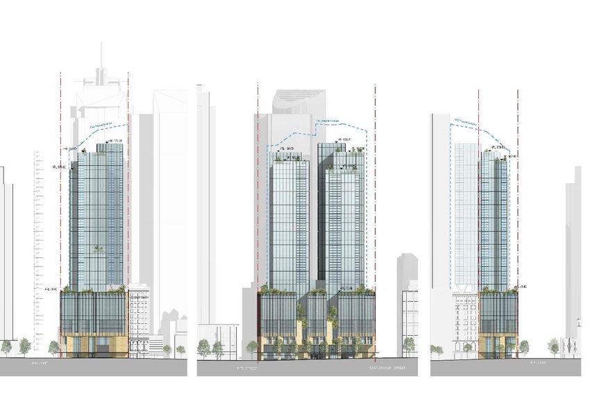
Table of Contents

1.     Purpose of this report ........................................................................................... 3
       1.1.       Background ............................................................................................... 3
       1.2.       Overview of the Sydney Metro in its context .............................................. 3
       1.3.       Planning relationship between Pitt Street Station and the OSD ................. 6
       1.4.       The Site ..................................................................................................... 8
       1.5.       Overview of the proposed development ................................................... 10
       1.6.       Staging and framework for managing environmental impacts .................. 12
2.     Introduction ......................................................................................................... 15
       2.1.       The Development .................................................................................... 15
3.     Prescribed Airspace ............................................................................................ 15
       3.1.       Overview ................................................................................................. 15
       3.2.       Obstacle Limitation Surfaces ................................................................... 16
       3.3.       Impact of development on Sydney Airport OLS ....................................... 16
       3.4.       Other Airport OLS .................................................................................... 17
       3.5.       Impact of the development on Sydney Airport PANS OPS ....................... 17
       3.6.       Nearby Airport PANS OPS ...................................................................... 17
4.     ATC Surveillance System Performance ............................................................. 18
5.     Navigation Aid Performance............................................................................... 19
       5.1.       Sydney Airport ......................................................................................... 19
       5.2.       Other Airport’s Navigation Aids ................................................................ 19
6.     Roof Top Exhaust Plumes .................................................................................. 19
7.     Obstacle Lighting ................................................................................................ 19
8.     Helicopter operations in the Vicinity .................................................................. 19
9.     Consultation and Approval Process .................................................................. 20
Appendix A ........................................................................................................................ 21
       Building Envelope and Elevations ......................................................................... 21
Appendix B ........................................................................................................................ 26
       Assessment Methodology ..................................................................................... 26
Appendix C ........................................................................................................................ 27
       Glossary of Aeronautical Terms and Abbreviations ............................................... 27
       Abbreviations ........................................................................................................ 30

 © Sydney Metro 2018                                                                                                  Page 2 of 32

                                            Sydney Metro City & Southwest | Pitt Street North Over Station Development EIS
1. Purpose of this report
1.1. Background
This report supports a concept State Significant Development Application (concept SSD
Application) submitted to the Department of Planning and Environment (DPE) pursuant to
Part 4 of the Environmental Planning and Assessment Act 1979 (EP&A Act). The concept
SSD Application is made under section 4.22 of the EP&A Act.
Sydney Metro is seeking to secure concept approval for a mixed use tower above the
northern portal of Pitt Street Station, otherwise known as the over station development
(OSD). The concept SSD Application seeks consent for a building envelope and its use for
residential accommodation, visitor accommodation and commercial premises, maximum
gross floor area (GFA), pedestrian and vehicular access, circulation arrangements and
associated car parking as well as the strategies and design parameters for the future
detailed design of development.
Sydney Metro proposes to construct the OSD as part of an integrated station development
package, which would result in the combined delivery of the station, OSD and public domain
improvements. The station and public domain elements form part of a separate planning
approval for Critical State Significant Infrastructure (CSSI) approved by the Minister for
Planning on 9 January 2017.
As the development is within a rail corridor, is associated with railway infrastructure and is
for the purposes of residential or commercial premises with a Capital Investment Value of
more than $30 million, the project is State Significant Development (SSD) pursuant to
Schedule 1, clause 19(2)(a) of the State Environmental Planning Policy (State and Regional
Development) 2011 (SRD SEPP). The full extent of the proposed development is also State
Significant Development by virtue of clause 8(2) of the SRD SEPP.
This report has been prepared to respond to the Secretary’s Environmental Assessment
Requirements (SEARs) issued for the concept SSD Application for Pitt Street North on 30th
November 2017 which state that the Environmental Impact Statement (EIS) is to address the
following requirement:
Prescribed Airspace for Sydney Airport
1.2. Overview of the Sydney Metro in its context
The New South Wales (NSW) Government is implementing Sydney’s Rail Future, a plan to
transform and modernise Sydney’s rail network so that it can grow with the city’s population
and meet the needs of customers in the future (Transport for NSW, 2012). Sydney Metro is
a new standalone rail network identified in Sydney’s Rail Future.
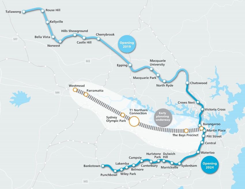
Sydney Metro is Australia’s biggest public transport project, consisting of Sydney Metro
Northwest, which is scheduled for completion in 2019 and Sydney Metro City & Southwest,
which is scheduled for completion in 2024.
Sydney Metro West is expected to be operational in the late 2020s. (Refer to Figure 1).
© Sydney Metro 2018 Page 3 of 32
Sydney Metro City & Southwest | Pitt Street North Over Station Development EIS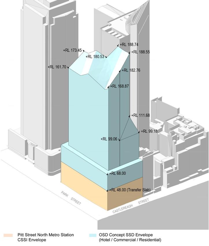
Figure 1: Sydney Metro alignment map

Sydney Metro City & Southwest includes the construction and operation of a new metro rail
line from Chatswood, under Sydney Harbour through Sydney’s CBD to Sydenham and on to
Bankstown through the conversion of the existing line to metro standards.
The project also involves the delivery of seven new metro stations, including at Pitt Street.
Once completed, Sydney Metro will have the ultimate capacity for 30 trains an hour (one
every two minutes) through the CBD in each direction - a level of service never seen before
in Sydney.
On 9 January 2017, the Minister for Planning approved the Sydney Metro City & Southwest -
Chatswood to Sydenham application as a Critical State Significant Infrastructure project
(reference SSI 15_7400), hereafter referred to as the CSSI Approval.
The CSSI Approval includes all physical work required to construct the CSSI, including the
demolition of existing buildings and structures on each site. Importantly, the CSSI Approval
also includes provision for the construction of below and above-ground structures and other
components of the future ISD (including building infrastructure and space for future lift cores,
plant rooms, access, parking and building services, as relevant to each site). The rationale

 © Sydney Metro 2018                                                                                     Page 4 of 32

                                       Sydney Metro City & Southwest | Pitt Street North Over Station Development EIS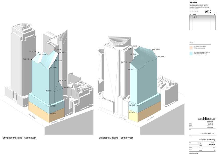
for this delivery approach, as identified within the CSSI Application, is to enable the ISD to
be more efficiently built and appropriately integrated into the metro station structure.
The EIS for the Chatswood to Sydenham component of the Sydney Metro City & Southwest
project identified that the OSD would be subject to a separate assessment process.
Since the CSSI Approval was issued, Sydney Metro has lodged four modification
applications to amend the CSSI Approval as outlined below:
    •   Modification 1- Victoria Cross and Artarmon Substation which involves relocation of
        the Victoria Cross northern services building from 194-196A Miller Street to 50
        McLaren Street together with inclusion of a new station entrance at this location
        referred to as Victoria Cross North. 52 McLaren Street would also be used to
        support construction of these works. The modification also involves the relocation of
        the substation at Artarmon from Butchers Lane to 98 – 104 Reserve Road. This
        modification application was approved on 18 October 2017.
    •   Modification 2- Central Walk which involves additional works at Central Railway
        Station including construction of a new eastern concourse, a new eastern entry, and
        upgrades to suburban platforms. This modification application was approved on 21
        December 2017.
    •   Modification 3 - Martin Place Station which involves changes to the Sydney Metro
        Martin Place Station to align with the Unsolicited Proposal by Macquarie Group
        Limited (Macquarie) for the development of the station precinct. The proposed
        modification involves a larger reconfigured station layout, provision of a new unpaid
        concourse link and retention of the existing MLC pedestrian link and works to
        connect into the Sydney Metro Martin Place Station. It is noted that if the Macquarie
        proposal does not proceed, the modification (if approved) would be surrendered.
        This modification application was approved on 22 March 2018.
    •   Modification 4 - Sydenham Station and Sydney Metro Trains Facility South which
        incorporated Sydenham Station and precinct works, the Sydney Metro Trains Facility
        South, works to Sydney Water’s Sydenham Pit and Drainage Pumping Station and
        ancillary infrastructure and track and signalling works into the approved project. This
        modification application was approved on 13 December 2017.
Given the modifications, the CSSI Approval is now approved to operate to Sydenham
Station and also includes the upgrade of Sydenham Station.

The remainder of the City & Southwest project (Sydenham to Bankstown) proposes the
conversion of the existing heavy rail line and the upgrade of the existing railway stations
along this alignment to metro standards. This portion of the project, referred to as the
Sydenham to Bankstown Upgrade, is the subject of a separate CSSI Application (No. SSI
17_8256) for which an Environmental Impact Statement was exhibited between September
and November 2017 and a Response to Submissions and Preferred Infrastructure Report
was submitted to the NSW Department of Planning & Environment (DPE) in June 2018 for
further exhibition and assessment.

 © Sydney Metro 2018                                                                             Page 5 of 32

                               Sydney Metro City & Southwest | Pitt Street North Over Station Development EIS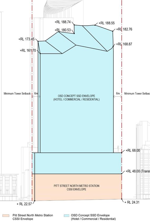
1.3.      Planning relationship between Pitt Street Station and the
          OSD
While the northern portal of Pitt Street Station and the OSD will form an Integrated Station
Development, the planning pathways defined under the Environmental Planning and
Assessment Act 1979 require separate approval for each component of the development. In
this regard, the approved station works (CSSI Approval) are subject to the provisions of Part
5.1 of the EP&A Act (now referred to as Division 5.2) and the OSD component is subject to
the provisions of Part 4 of the EP&A Act.

For clarity, the approved station works under the CSSI Approval included the construction of
below and above ground structures necessary for delivering the station and also enabling
construction of the integrated OSD. This included but is not limited to:

    •   demolition of existing development
    •   excavation
    •   station structure including concourse and platforms
    •   lobbies
    •   retail spaces within the station building
    •   public domain improvements
    •   station portal link (between the northern and southern portals of Pitt Street Station)
    •   access arrangements including vertical transport such as escalators and lifts
    •   structural and service elements and the relevant space provisioning necessary for
        constructing OSD, such as columns and beams, space for lift cores, plant rooms,
        access, parking, retail and building services.
The vertical extent of the approved station works above ground level is defined by the
‘transfer slab’ level (which for Pitt Street North is defined by RL 48.00), above which would
sit the OSD. This delineation is illustrated in Figure 2 below.

 © Sydney Metro 2018                                                                              Page 6 of 32

                                Sydney Metro City & Southwest | Pitt Street North Over Station Development EIS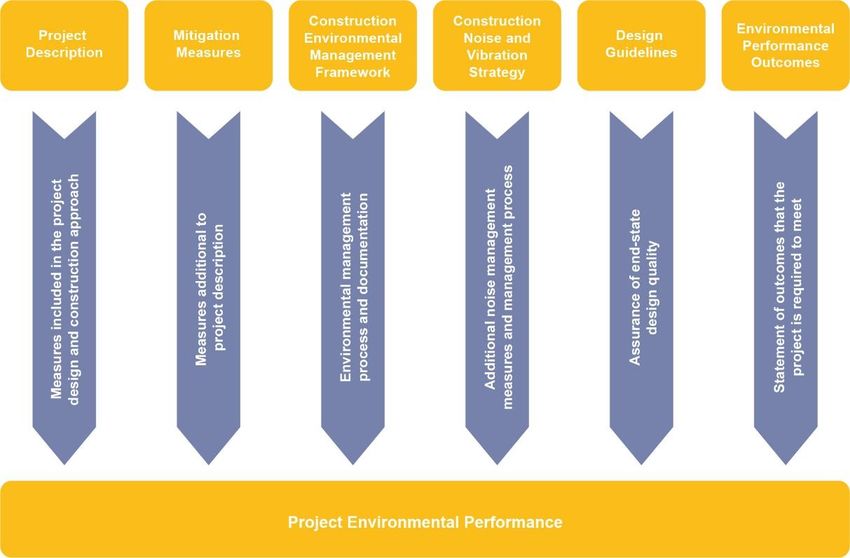
Figure 2: Delineation between station and OSD

The CSSI Approval also establishes the general concept for the ground plane of Pitt Street
Station including access strategies for commuters, pedestrians and workers. In this regard,
pedestrian access to the station would be from Park Street and the OSD lobbies would be
accessed from Pitt Street, Park Street and Castlereagh Street.

Since the issue of the CSSI Approval, Sydney Metro has undertaken sufficient design work
to determine the space planning and general layout for the station and identification of those

 © Sydney Metro 2018                                                                                     Page 7 of 32

                                       Sydney Metro City & Southwest | Pitt Street North Over Station Development EIS
spaces within the station area that would be available for the OSD. In addition, design work
has been undertaken to determine the technical requirements for the structural integration of
the OSD with the station. This level of design work has informed the concept proposal for the
OSD. It is noted that ongoing design development of the works to be delivered under the
CSSI Approval would continue with a view to developing an Interchange Access Plan (IAP)
and Station Design Precinct Plan (SDPP) for Pitt Street Station to satisfy Conditions E92 and
E101 of the CSSI Approval.
The public domain improvement works around the site would be delivered as part of the
CSSI Approval.
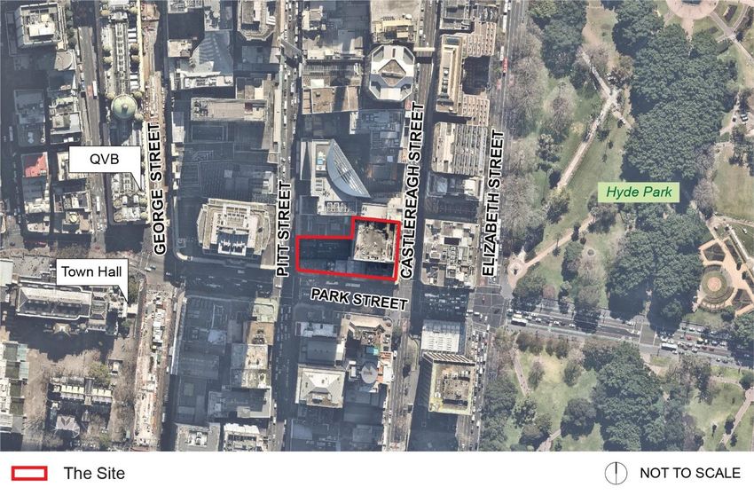
1.4. The Site
The Pitt Street North OSD site is located at the southern portion of the Sydney CBD block
bounded by Pitt Street, Park Street and Castlereagh Street, above the northern portal of the
future Pitt Street Station (refer to Figure 3 below).
Figure 3: Pitt Street Station location plan
© Sydney Metro 2018 Page 8 of 32
Sydney Metro City & Southwest | Pitt Street North Over Station Development EISThe site is located in the City of Sydney Local Government Area. The site (refer to Figure 4
below) is irregular in shape, has a total area of approximately 3,150 square metres and has
street frontages of approximately 28 metres to Pitt Street, 81 metres to Park Street and 48
metres to Castlereagh Street.
The site address is 175-183 Castlereagh Street, Sydney and comprises the following
properties:
• Lot 3 in DP 74952
• Lot 1 in DP 229365
• Lot 2 in DP 900055
• Lot 1 in DP 596474
• Lot 17 in DP 1095869
• Lot 2 in DP 509677
• Lot 1 in DP 982663
• Lot 2 in DP 982663
• Lot 3 in DP 61187
• Lot 1 in DP 74367
Figure 4: Aerial photo of Pitt Street North
© Sydney Metro 2018 Page 9 of 32
Sydney Metro City & Southwest | Pitt Street North Over Station Development EIS1.5. Overview of the proposed development
The concept SSD Application seeks concept approval in accordance with section 4.22 of the
EP&A Act for the OSD above the approved Pitt Street Station (northern portal). This
Application establishes the planning framework and strategies to inform the detailed design
of the future OSD and specifically seeks planning approval for:
• a building envelope as illustrated at Figure 5
• a maximum building height of approximately Relative Level (RL) 189 which equates
to approximately 43 storeys including a podium height of RL68 (approximately 45m),
which equates to approximately 12 storeys above ground
• a maximum GFA of 49,120 square metres for the OSD component, which equates to
a Floor Space Ratio (FSR) of 15.59:1, resulting in a total maximum GFA at the site
(including station floorspace) of 50,309 square metres and a total maximum FSR of
15.97:1, including flexibility to enable a change in the composition of land uses within
the maximum FSR sought
• conceptual use of the building envelope for a range of uses including commercial
office space, visitor accommodation and residential accommodation
• use of the conceptual OSD space provisioning within the footprint of the CSSI
Approval (both above and below ground), including the OSD lobby areas, podium car
parking, storage facilities, services and back-of-house facilities
• car parking for approximately 50 spaces located across five levels of the podium
• loading and vehicular access arrangements from Pitt Street
• pedestrian access from Pitt Street, Park Street and Castlereagh Street
• strategies for utilities and service provision
• strategies for the management of stormwater and drainage
• a strategy for the achievement of ecologically sustainable development
• indicative signage zones
• a strategy for public art
• a design excellence framework
• the future subdivision of parts of the OSD footprint (if required)
As this concept SSD Application is a staged development pursuant to section 4.22 of the
EP&A Act, future approval would be sought for detailed design and construction of the OSD.
A concept indicative design, showing a potential building form outcome at the site, has been
provided as part of this concept SSD Application at Appendix E.
Pitt Street Station is to be a key station on the future Sydney Metro network, providing
access to the Sydney Central Business District (CBD). The proposal combines the metro
station with a significant mixed use tower, contributing to the Sydney skyline. The OSD
would assist in strengthening the role of Central Sydney as the key centre of business in
Australia and would contribute to the diversity, amenity and sustainability of the CBD.
It is noted that Pitt Street Station southern portal OSD has been subject to a separate
application, and does not form part of this concept SSD Application.
© Sydney Metro 2018 Page 10 of 32
Sydney Metro City & Southwest | Pitt Street North Over Station Development EISFigure 5: Pitt Street North OSD building, including OSD components (orange) and station box (grey)
© Sydney Metro 2018 Page 11 of 32
Sydney Metro City & Southwest | Pitt Street North Over Station Development EISFigure 6: Pitt Street North OSD indicative design, as seen from eastern, southern and western elevations
1.6. Staging and framework for managing environmental impacts
Sydney Metro proposes to procure the delivery of the Pitt Street North integrated station
development in one single package, which would entail the following works:
• station structure
• station fit-out, including mechanical and electrical
• OSD structure
• OSD fit-out, including mechanical and electrical.
Separate delivery packages are also proposed by Sydney Metro to deliver the excavation of
the station boxes/shafts ahead of the ISD delivery package, and line-wide systems (e.g.
track, power, ventilation) and operational readiness works prior to the Sydney Metro City &
Southwest metro system being able to operate.
Three possible staging scenarios have been identified for delivery of the Integrated Station
Development:
1. Scenario 1 – the station and OSD are constructed concurrently by constructing the
transfer slab first and then building in both directions. Both the station and OSD
would be completed in 2024.
© Sydney Metro 2018 Page 12 of 32
Sydney Metro City & Southwest | Pitt Street North Over Station Development EIS2. Scenario 2 – the station is constructed first and ready for operation in 2024. OSD
construction may still be incomplete or soon ready to commence after station
construction is completed. This means that some or all OSD construction is likely to
still be underway upon opening of the station in 2024.
3. Scenario 3 – the station is constructed first and ready for operation in 2024. The OSD
is built at a later stage, with timing yet to be determined. This creates two distinct
construction periods for the station and OSD.
Scenario 1 represents Sydney Metro’s preferred option as it would provide for completion of
the full integrated station development and therefore the optimum public benefit at the site at
the earliest date possible (i.e. on or near 2024 when the station is operational). However,
given the delivery of the OSD could be influenced by property market forces, Scenarios 2 or
3 could also occur, where there is a lag between completion of the station component of the
ISD (station open and operational), and a subsequent development.
The final staging for the delivery of the OSD would be resolved as part of the detailed SSD
Application(s).
For the purposes of providing a high level assessment of the potential environmental
impacts associated with construction, the following have been considered:
• Impacts directly associated with the OSD, the subject of this SSD Application
• Cumulative impacts of the construction of the OSD at the same time as the station
works (subject of the CSSI Approval).
Given the integration of the delivery of the Sydney Metro City & Southwest metro station with
an OSD development, Sydney Metro proposes the framework detailed in
Figure 7 to manage the design and environmental impacts, consistent with the framework
adopted for the CSSI Approval, which includes:
• project design – measures which are inherent in the design of the project to avoid
and minimise impacts
• mitigation measures – additional to the project design which are identified through
the environmental impact assessment
• construction environmental management framework – details the management
processes and documentation for the project
• construction noise and vibration strategy – identifies measures to manage
construction noise and vibration
• design guidelines – provides an assurance of end-state quality
• environmental performance outcomes – establishes intended outcomes which would
be achieved by the project
© Sydney Metro 2018 Page 13 of 32
Sydney Metro City & Southwest | Pitt Street North Over Station Development EISFigure 7: Project approach to environmental mitigation and management
Sydney Metro proposes to implement a similar environmental management framework
where the integrated delivery of the CSSI station works and the OSD occur concurrently.
This would ensure a consistent approach to management of design interface and
construction-related issues.
Sydney Metro proposes this environmental management framework would apply to the OSD
until completion of the station and public domain components of the integrated station
development delivery contract (i.e. those works under the CSSI Approval). Should the OSD
be constructed beyond the practical completion and opening of the section, standard
practices for managing construction related environmental impacts would apply in
accordance with the relevant guidelines and Conditions of Approval for the detailed SSD
Application(s).
© Sydney Metro 2018 Page 14 of 32
Sydney Metro City & Southwest | Pitt Street North Over Station Development EIS2. Introduction
2.1. The Development
Sydney Metro has tasked Landrum & Brown Worldwide (Australia) Pty Ltd to prepare an
Aeronautical Impact Assessment (AIA) for the proposed over station development (OSD) at
Pitt Street North, Sydney, NSW.
The development site is located in the Central Business District of Sydney, approximately 8
km north of Sydney Airport.
The building envelope encompasses the area between Pitt Street, Park Street and
Castlereagh Street to a maximum height of 188.74 m AHD to avoid overshadowing of Hyde
Park between control times.
3. Prescribed Airspace
3.1. Overview
Prescribed Airspace for an airport is the airspace above any part of either an Obstacle
Limitation Surface (OLS) or a PANS OPS (Procedures for Air Navigation Services – Aircraft
Operations) surface for the airport.
The OLS are conceptual surfaces associated with runways that are designed to protect
aircraft operations from unrestricted obstacle growth. The OLS at Sydney Airport comprises
the following:
• outer horizontal surface (OHS);
• conical surface;
• inner horizontal surface (IHS);
• approach surface;
• inner approach surface;
• transitional surface;
• inner transitional surface;
• baulked landing surface; and
• take-off climb surface.
The PANS OPS surfaces are designed to guarantee an obstacle free path to and from a
runway, with a prescribed minimum obstacle clearance above the obstacles or terrain, for
the safety of aircraft operations in Instrument Meteorological Conditions (IMC).
Infringement by a building or crane through the OLS requires the support of Sydney Airport
Corporation Limited (SACL), and the approval of the Civil Aviation Safety Authority (CASA),
and the Department of Infrastructure, Regional Development and Cities (DIRDC).
© Sydney Metro 2018 Page 15 of 32
Sydney Metro City & Southwest | Pitt Street North Over Station Development EISInfringement of the PANS OPS surfaces are not supported by the authorities.
3.2. Obstacle Limitation Surfaces
The development is located underneath the Obstacle Limitation Surface for Sydney Airport.
Figure 8 depicts the proposed development location in relation to the OLS diagram, as
published in the Sydney Airport Master Plan 2015.
Figure 8: Development site in relation to Sydney Airport’s OLS (Source: Sydney Airport Ltd Master Plan 2015)
3.3. Impact of development on Sydney Airport OLS
The lowest of the OLS above the development site is the Outer Horizontal Surface (OHS), at
a height of 156 m AHD. The proposed building envelope will infringe this surface by 32.74 m.
According to the Manual of Standards Part 139 – Aerodromes, a new obstacle located in the
vicinity of an existing obstacle which has already been assessed as not presenting a hazard
to aircraft operations, is deemed to be shielded. A shielded obstacle should not require
marking or lighting.
The proposed development is shielded by Sydney Tower at 100 Market Street, as well as
several other buildings in the vicinity.
Table 1 identifies the heights of Sydney Airport’s Prescribed Airspace above the
development site, and identifies an infringement (in red) or clearance height (in green).
© Sydney Metro 2018 Page 16 of 32
Sydney Metro City & Southwest | Pitt Street North Over Station Development EISInfringement by
Runway Height of surface
Sydney Airport OSD Envelope
(RWY) (m AHD)
of 188.74 m AHD
Outer Horizontal Surface (OHS) All Runways 156 32.74
PANS OPS Departure 34R 331 142.26
PANS OPS Departure 34L 367 178.26
PANS OPS Departure 07 304 115.26
PANS OPS Approaches All Runways NA NA
PANS OPS 25 nm MSA NA 518 329.26
PANS OPS 10 nm MSA NA 335 146.26
Radar Terrain Clearance Chart NA 335 146.26
Table 1: Sydney Airport Prescribed Airspace Heights above site (Source: Landrum & Brown)
3.4. Other Airport OLS
No other airports have OLS existing above the proposed development site.
3.5. Impact of the development on Sydney Airport PANS OPS
The lowest PANS OPS surface above the OSD site is 304 m AHD, and is related to the
departure procedure for Runway 07.
This site will not infringe the Sydney Airport PANS OPS surfaces.
3.6. Nearby Airport PANS OPS
The following airports have PANS OPS surfaces related to their 25 nm Minimum Safe
Altitude (MSA):
• RAAF Base Richmond;
• Camden;
• Bankstown; and
• Western Sydney Airport (under development).
Due to the distance from these airports, the proposed development does not infringe the
associated PANS OPS.
Table 2 depicts the lowest PANS OPS surface above the development site for each airport.
Aerodrome PANS OPS Surface Height (m) Impact of OSD
RAAF Base Richmond 457 Nil
© Sydney Metro 2018 Page 17 of 32
Sydney Metro City & Southwest | Pitt Street North Over Station Development EISAerodrome PANS OPS Surface Height (m) Impact of OSD
Camden 1340 Nil
Bankstown 700 Nil
Western Sydney Airport Under Development Will not have an impact
Table 2: Nearby Airport PANS OPS Surface Heights (Source: Landrum & Brown)
4. ATC Surveillance System Performance
This assessment identified two radars in relative proximity to the development at the Pitt
Street North site. These are the Sydney Airport Terminal Area Radar (TAR), and the Cecil
Park TAR.
The OSD envelope, at a height of 188.74 m AHD, will infringe the Sydney Airport TAR
clearance plane. This plane is infringed by every building in the area that reaches a height of
115.9 m AHD or above.
This issue is recognised by Airservices Australia and has been mitigated by the placement of
the Cecil Park radar, and more recently ADS-B receivers, to ensure that ATC receives
adequate surveillance coverage for the airspace around the Sydney Basin airports.
A Radar Terrain Clearance Chart (RTCC) protection surface exists above the site. This
surface relates to the lowest level that aircraft are able to descend to whilst under the
direction of Air Traffic Control (ATC). The RTCC height above the OSD is 335 m AHD, and
therefore is not impacted by the proposed development.
Table 3 depicts the impact of the development on the performance of the ATC Surveillance
System Performance.
Plane elevation
at Pitt Street Infringement
Distance Distance Antenna
Surveillance North Site result for building
from in Elevation
System (m AHD) envelope of
development metres (m AHD)
Distance x Tan 0.5 188.74 m AHD
+ TAR elevation
Sydney Airport 8.9 km
8900 38.2 115.9 Infringement
TAR North East
34.35 km
Cecil Park TAR 34350 200.51 500.3 No infringement
West
RTCC Overhead 335 No infringement
Table 3: Impact of development on ATC Surveillance System Performance (Source – Landrum & Brown)
© Sydney Metro 2018 Page 18 of 32
Sydney Metro City & Southwest | Pitt Street North Over Station Development EIS5. Navigation Aid Performance
5.1. Sydney Airport
There are a number of navigation aids installed at Sydney Airport including ILS, GBAS and
DME.
The Building Restricted Areas (BRA) describe a sensitive zone that exists to prescribed radii
from the navigation aid antenna sites. The development limitations within the BRA is
specified in the Airservices Australia document Navigation Aid Building Restricted Areas and
Siting Guidance AEI-7.1613 Issue 2.
The development site is located outside of all BRA for all of the Sydney Airport navigation
aids.
5.2. Other Airport’s Navigation Aids
The development site is not located within the BRA for any navigation aids at other airports,
and therefore will not affect the operation of those navigation aids.
6. Roof Top Exhaust Plumes
Exhaust plumes on top of the building with an exit velocity in excess of 4.3 m/s should be
referred to CASA for assessment and determination of whether a hazard exists.
7. Obstacle Lighting
As the proposed development will be assessed by the authorities to be shielded by existing
CBD buildings, there should be no requirement for obstruction lighting.
8. Helicopter operations in the Vicinity
Helicopter operations within the Sydney CBD take place during daylight hours and in Visual
Meteorological Conditions (VMC), whereby the pilots can see and avoid all obstacles in the
environment in which they are operating. Although Police and Ambulance helicopters may
be required to operate during hours of darkness, they will still operate on a visual basis.
The main helicopter routes within the Sydney Control Zone are not located near the
development site.
The building envelope will not impact upon helicopter flight operations in this area.
© Sydney Metro 2018 Page 19 of 32
Sydney Metro City & Southwest | Pitt Street North Over Station Development EIS9. Consultation and Approval Process
Prior to commencing this assessment, L&B contacted the Airspace Protection Office of
Sydney Airport Corporation Limited (SACL) to confirm the process for approval of new
obstacles.
Peter Bleasdale, the Airfield Design Manager for SACL, advised that all developments
planned above 156 m AHD in the central business district of Sydney would require the
approval of the Department of Infrastructure, Regional development and Cities (DIRDC).
In the case of the OSD at Pitt Street North, an application to infringe the OLS must be prepared
and submitted to SACL. The Airspace Protection Office will review the application, and forward
to Airservices Australia and the Civil Aviation Safety Authority (CASA) for their assessment.
All comments will be delivered to the DIRDC, who will adjudicate based on the evidence
provided by the other authorities.
This approval process usually takes three months and will be undertaken as part of the
detailed SSD Application process. As confirmed by the SACL Airfield Design Manager, this
development is shielded by existing buildings in the Sydney CBD, and will not impose any
additional hazard to aviation activities.
© Sydney Metro 2018 Page 20 of 32
Sydney Metro City & Southwest | Pitt Street North Over Station Development EISAppendix A
Building Envelope and Elevations
Envelope – Tower (Architectus)
© Sydney Metro 2018 Page 21 of 32
Sydney Metro City & Southwest | Pitt Street North Over Station Development EISEnvelope – South Elevation (Architectus)
© Sydney Metro 2018 Page 22 of 32
Sydney Metro City & Southwest | Pitt Street North Over Station Development EISEnvelope – East Elevation (Architectus)
© Sydney Metro 2018 Page 23 of 32
Sydney Metro City & Southwest | Pitt Street North Over Station Development EISEnvelope – West Elevation (Architectus)
© Sydney Metro 2018 Page 24 of 32
Sydney Metro City & Southwest | Pitt Street North Over Station Development EISEnvelope – Massing South East and South West (Architectus)
© Sydney Metro 2018 Page 25 of 32
Sydney Metro City & Southwest | Pitt Street North Over Station Development EISAppendix B
Assessment Methodology
In preparing aeronautical impact assessments associated with airport safeguarding and
protection, it is necessary to observe the requirements of the relevant aviation authorities
including:
• The Department of Infrastructure, Regional Development and Cities (DIRDC);
• The Civil Aviation Safety Authority of Australia (CASA);
• Airservices Australia (ASA);
• Airport Operators; and
• Department of Defence, where appropriate.
The Airports Act 1996 and Airports (Protection of Airspace) Regulations 1996 prescribes the
volumes of airspace surrounding Federally Leased Airports that protect aircraft operations
into those airports, in order to ensure the safety and regularity of airline and other flight
operations.
Sydney Airport’s Prescribed Airspace comprises:
• Obstacle Limitation Surfaces (OLS) that restrict obstacle growth in the vicinity of
takeoff and landing paths; and
• PANS OPS surfaces that provide a buffer between flight paths and terrain or
obstacles.
Relevant Acts and Regulations applicable to developments near airports and air traffic
routes were referenced during this assessment.
The major relevant documents include:
• The Airports Act 1996, Airports (Protection of Airspace) Regulations 1996;
• Civil Aviation Safety Regulation (CASR) Part 139 Manual of Standards –
Aerodromes;
• Aeronautical Information Publication (AIP);
• Airservices Australia’s Airways Engineering Instruction – Navigation Aid Building
Restricted Areas and Siting Guidance (BRA);
• International Civil Aviation Organisation (ICAO) DOC 8168 Procedures for Air
Navigation – Aircraft Operations (PANS OPS).
© Sydney Metro 2018 Page 26 of 32
Sydney Metro City & Southwest | Pitt Street North Over Station Development EISAppendix C
Glossary of Aeronautical Terms and Abbreviations
To facilitate the understanding of aviation terminology used in this report, the following is a
glossary of terms and acronyms that are commonly used in aeronautical impact
assessments and similar aeronautical studies.
AC (Advisory Circulars) are issued by CASA and are intended to provide recommendations
and guidance to illustrate a means, but not necessarily the only means, of complying with
the Regulations.
Aeronautical study is a tool used to review aerodrome and airspace processes and
procedures to ensure that safety criteria are appropriate.
AIPs (Aeronautical Information Publications) are publications promulgated to provide
operators with aeronautical information of a lasting character essential to air navigation.
They contain details of regulations, procedures and other information pertinent to flying and
operation of aircraft. In Australia, AIP is issued by Airservices Australia on behalf of CASA.
Air routes exist between navigation aid equipped aerodromes or waypoints to facilitate the
regular and safe flow of aircraft operating under IFR.
Airservices Australia is the Australian government-owned corporation providing safe and
environmentally sound air traffic management and related airside services to the aviation
industry.
Altitude is the vertical distance of a level, a point or an object, considered as a point,
measured from mean sea level.
ATC (Air Traffic Control) service is a service provided for the purpose of:
a. preventing collisions:
1. between aircraft; and
2. on the manoeuvring area between aircraft and obstructions; and
b. expediting and maintaining an orderly flow of air traffic.
CASA (Civil Aviation Safety Authority) is the Australian government authority responsible
under the Civil Aviation Act 1988 for developing and promulgating appropriate, clear and
concise aviation safety standards. As Australia is a signatory to the ICAO Chicago
Convention, CASA adopts the standards and recommended practices established by ICAO,
except where a difference has been notified.
CASR (Civil Aviation Safety Regulations) are promulgated by CASA and establish the
regulatory framework (Regulations) within which all service providers must operate.
Civil Aviation Act 1988 (the Act) establishes the CASA with functions relating to civil
aviation, in particular the safety of civil aviation and for related purposes.
© Sydney Metro 2018 Page 27 of 32
Sydney Metro City & Southwest | Pitt Street North Over Station Development EISICAO (International Civil Aviation Organization) is an agency of the United Nations which
codifies the principles and techniques of international air navigation and fosters the planning
and development of international air transport to ensure safe and orderly growth. The ICAO
Council adopts standards and recommended practices concerning air navigation, its
infrastructure, flight inspection, prevention of unlawful interference, and facilitation of border-
crossing procedures for international civil aviation. In addition, the ICAO defines the
protocols for air accident investigation followed by transport safety authorities in countries
signatory to the Convention on International Civil Aviation, commonly known as the Chicago
Convention. Australia is a signatory to the Chicago Convention.
IFR (Instrument Flight Rules) are rules applicable to the conduct of flight under IMC. IFR are
established to govern flight under conditions in which flight by outside visual reference is not
safe. IFR flight depends upon flying by reference to instruments in the flight deck, and
navigation is accomplished by reference to electronic signals. It is also referred to as, “a term
used by pilots and controllers to indicate the type of flight plan an aircraft is flying,” such as
an IFR or VFR flight plan. Pilots must hold IFR qualifications and aircraft must be suitably
equipped with appropriate instruments and navigation aids to enable flight in IMC.
IMC (Instrument Meteorological Conditions) are meteorological conditions expressed in
terms of visibility, distance from cloud and ceiling, less than the minimum specified for visual
meteorological conditions.
LSALT (Lowest Safe Altitudes) are published for each low level air route segment. Their
purpose is to allow pilots of aircraft that suffer a system failure to descend to the LSALT to
ensure terrain or obstacle clearance in IMC where the pilot cannot see the terrain or
obstacles due to cloud or poor visibility conditions. It is an altitude that is at least 1,000 feet
above any obstacle or terrain within a defined safety buffer region around a particular route
that a pilot might fly.
MOS (Manual of Standards) comprises specifications (Standards) prescribed by CASA, of
uniform application, determined to be necessary for the safety of air navigation.
NOTAMs (Notices to Airmen) are notices issued by the NOTAM office containing information
or instruction concerning the establishment, condition or change in any aeronautical facility,
service, procedure or hazard, the timely knowledge of which is essential to persons
concerned with flight operations.
Obstacles. All fixed (whether temporary or permanent) and mobile objects, or parts thereof,
that are located on an area intended for the surface movement of aircraft or that extend
above a defined surface intended to protect aircraft in flight.
OLS (Obstacle Limitation Surfaces) are a series of planes associated with each runway at
an aerodrome that defines the desirable limits to which objects may project into the airspace
around the aerodrome so that aircraft operations may be conducted safely.
PANS OPS (Procedures for Air Navigation Services - Aircraft Operations) is an Air Traffic
Control term denominating rules for designing instrument approach and departure
procedures. Such procedures are used to allow aircraft to land and take off under Instrument
Meteorological Conditions (IMC) or Instrument Flight Rules (IFR). ICAO document 8168-
© Sydney Metro 2018 Page 28 of 32
Sydney Metro City & Southwest | Pitt Street North Over Station Development EISOPS/611 (volumes 1 and 2) outlines the principles for airspace protection and procedure
design which all ICAO signatory states must adhere to. The regulatory material surrounding
PANS OPS may vary from country to country.
PANS OPS Surfaces. Similar to an Obstacle Limitation Surface, the PANS OPS protection
surfaces are imaginary surfaces in space which guarantee the aircraft a certain minimum
obstacle clearance. These surfaces may be used as a tool for local governments in
assessing building development. Where buildings may (under certain circumstances) be
permitted to infringe the OLS, they cannot be permitted to infringe any PANS OPS surface,
because the purpose of these surfaces is to guarantee pilots operating under IMC an
obstacle free descent path for a given approach.
Prescribed airspace is an airspace specified in, or ascertained in accordance with, the
Regulations, where it is in the interests of the safety, efficiency or regularity of existing or
future air transport operations into or out of an airport for the airspace to be protected. The
prescribed airspace for an airport is the airspace above any part of either an OLS or a PANS
OPS surface for the airport and airspace declared in a declaration relating to the airport.
Radar Terrain Clearance Chart (RTCC) is a chart that provides air traffic controllers with
the lowest usable altitude that they can vector an aircraft using prescribed surveillance
procedures within controlled airspace. There is a protection surface below this usable
altitude which is shown in airport master plans.
Regulations (Civil Aviation Safety Regulations)
VFR (Visual Flight Rules) are rules applicable to the conduct of flight under VMC. VFR allow
a pilot to operate an aircraft in weather conditions generally clear enough to allow the pilot to
maintain visual contact with the terrain and to see where the aircraft is going. Specifically,
the weather must be better than basic VFR weather minima. If the weather is worse than
VFR minima, pilots are required to use instrument flight rules. Pilots must be specifically
qualified and aircraft specifically equipped to enable flight in IMC,
VMC (Visual Meteorological Conditions) are meteorological conditions expressed in terms of
visibility, distance from cloud and ceiling, equal or better than specified minima.
© Sydney Metro 2018 Page 29 of 32
Sydney Metro City & Southwest | Pitt Street North Over Station Development EISAbbreviations
Abbreviations used in this report, and the meanings assigned to them for the purposes of
this report are detailed in the following table.
Abbreviation Meaning
AC Advisory Circular (document support CAR 1998)
ACFT Aircraft
AD Aerodrome
ADS-B Automatic Dependent Surveillance - Broadcast
AHD Australian Height Datum
AIP Aeronautical Information Publication
Airports Act Airports Act 1996, as amended
AIS Aeronautical Information Service
ALT Altitude
AMSL Above Mean Sea Level
APARs Airports (Protection of Airspace) Regulations, 1996 as amended
ARP Aerodrome Reference Point
AsA Airservices Australia
ATC Air Traffic Control(ler)
ATM Air Traffic Management
BRA Building Restricted Area
CAO Civil Aviation Order
CAR Civil Aviation Regulation
CASA Civil Aviation Safety Authority
CASR Civil Aviation Safety Regulation
Cat Category
DAP Departure and Approach Procedures (charts published by AsA)
DER Departure End of (the) Runway
DME Distance Measuring Equipment
Doc nn ICAO Document Number nn
DIT Department of Infrastructure and Transport. (Formerly Dept. of Infrastructure,
Transport, Regional Development and Local Government and Department of
Transport and Regional Services (DoTARS))
DOTARS See DIT above
ELEV Elevation (above mean sea level)
ENE East North East
© Sydney Metro 2018 Page 30 of 32
Sydney Metro City & Southwest | Pitt Street North Over Station Development EISAbbreviation Meaning
ERSA Enroute Supplement Australia
FAF Final Approach Fix
FAP Final Approach Point
ft feet
GBAS Ground Based Augmentation System (satellite precision landing system)
GNSS Global Navigation Satellite System
GP Glide Path
IAS Indicated Airspeed
ICAO International Civil Aviation Organisation
IHS Inner Horizontal Surface, an Obstacle Limitation Surface
ILS Instrument Landing System
ISA International Standard Atmosphere
km kilometres
kt Knot (one nautical mile per hour)
LAT Latitude
LLZ Localizer
LONG Longitude
m metres
MAPt Missed Approach Point
MDA Minimum Descent Altitude
MGA94 Map Grid Australia 1994
MOC Minimum Obstacle Clearance
MOS Manual of Standards, published by CASA
MSA Minimum Sector Altitude
MVA Minimum Vector Altitude
NASAG National Airports Safeguarding Advisory Group
NDB Non Directional Beacon
NE North East
NM Nautical Mile (= 1.852 km)
nnDME Distance from the DME (in nautical miles)
NNE North North East
NOTAM NOtice to AirMen
OAS Obstacle Assessment Surface
OCA Obstacle Clearance Altitude
© Sydney Metro 2018 Page 31 of 32
Sydney Metro City & Southwest | Pitt Street North Over Station Development EISAbbreviation Meaning
OCH Obstacle Clearance Height
OHS Outer Horizontal Surface
OIS Obstacle Identification Surface
OLS Obstacle Limitation Surface
PANS OPS Procedures for Air Navigation Services – Aircraft Operations, ICAO Doc 8168
PBN Performance Based Navigation
PRM Precision Runway Monitor
QNH An altimeter setting relative to height above mean sea level
REF Reference
RL Relative Level
RNAV aRea NAVigation
RNP Required Navigation Performance
RPA Rules and Practices for Aerodromes
— replaced by the MOS Part 139 — Aerodromes
RPT Regular Public Transport
RTCC Radar Terrain Clearance Chart
RWY Runway
SFC Surface
SID Standard Instrument Departure
SOC Start Of Climb
STAR STandard ARrival
SGHAT Solar Glare Hazard Analysis Tool
TAR Terminal Approach Radar
TAS True Air Speed
THR Threshold (Runway)
TNA Turn Altitude
TODA Take-Off Distance Available
Vn aircraft critical Velocity reference
VOR Very high frequency Omni directional Range
WAC World Aeronautical Chart
© Sydney Metro 2018 Page 32 of 32
Sydney Metro City & Southwest | Pitt Street North Over Station Development EISYou can also read