Of the Blessington Local Area Plan 2013 - 2019 Strategic Environmental Assessment
←
→
Page content transcription
If your browser does not render page correctly, please read the page content below
Of the
    Blessington Local Area Plan
            2013 – 2019
Strategic Environmental Assessment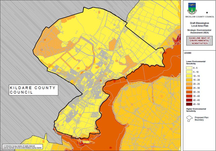
SEA Statement Table of Contents

                                                                           Page No.

Section 1 Introduction:                                                       1

1.1 Terms of Reference                                                        1

1.2 SEA Definition                                                            1

1.3 Legislative Context                                                       1

1.4 Content of the SEA Statement                                              1

1.5 Implications of SEA for the Plan                                          1

Section 2 How Environmental Considerations were integrated into the Plan      3

2.1 Consultations                                                             3

2.2 Environmental Sensitivities                                               3

2.2.1 Mapping and Early Communication                                         3

2.2.2 Overlay mapping                                                         4

2.3 Early Identification and Evaluation of Alternatives                       4

2.4 Mitigation                                                               11

2.4.1 Introduction                                                           11

Section 3 Environmental Report and Submissions & Observations                14

3.1 Introduction                                                             14

3.2 SEA Scoping Submissions                                                  14

3.3 Draft Environmental Report Submissions and Observations:                 15

3.4 The Environmental Report:                                                17

Section 4 Alternative Plan Scenarios Considered                              18

4.1 Introduction                                                             18

4.2 Description of the Alternative Scenarios                                 18

4.2.1 Scenario 1 Minimal Development Envelope                                18

4.2.2 Scenario 2 Moderate Development Envelope                               20

4.2.3 Scenario 3 Maximum Development Envelope                                22

4.3 Evaluation of Alternative Plan Scenarios                                 24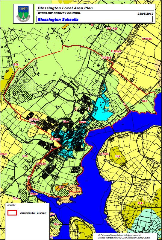
Page No.

4.3.1 Methodology                                                                    24

4.3.1.1 Existing Environment and Overlay Mapping                                     24

4.3.1.2 Strategic Environmental Objectives (SEOs)                                    24

4.3.2 Evaluation of Alternative Plan Scenarios                                       27

4.3.2.1 Introduction                                                                 27

4.3.2.2 Alternative Scenario 1 – Minimal Development Envelope                        27

4.3.2.3 Alternative Scenario 2 – Moderate Development Envelope                       27

4.3.2.4 Alternative Scenario 3 – Maximum Development Envelope                        28

4.3.2.5 Evaluation against SEOs                                                      29

4.4. Reasons for choosing the Plan in light of the other reasonable alternatives

dealt with                                                                           30

Section 5 Monitoring Measures                                                        31

5.1 Introduction                                                                     31

5. 2 Indicators and Targets                                                          31

5.3 Sources                                                                          31

5.4 Excluded Indicators and Targets                                                  31

5.5 Reporting                                                                        31

5.6 Responsibility                                                                   32

5.7 Thresholds                                                                       32

SEA Statement List of Figures

Figure 2.1 Environmental Sensitivities - 1                                            5

Figure 2.2 Environmental Sensitivities - 2                                            6

Figure 2.3 Environmental Sensitivities - 3                                            7

Figure 2.4 Environmental Sensitivities - 4                                            8

Figure 2.5 (a) Sample of Overlay Mapping to derive overall Environmental

sensitivity                                                                           9

Figure 2.5 (b) Overlay Mapping to derive overall Environmental sensitivity           10

Figure 4.1 –Scenario 1 – Minimal Development Envelope                                19

Figure 4.2 –Scenario 2 – Moderate Development Envelope                               21

Figure 4.3 –Scenario 3 – Maximum Development Envelope                                23

Figure 4.4 Environmental Sensitivity mapping                                         26
Page No.

SEA Statement List of Tables

Table 2.1 (a)Blessington Specific Mitigation measures and related objectives            12

Table 2.1 (b)Wicklow CDP Mitigation measures and related objectives                     13

Table 4.1 above: Criteria for appraising the effect of Plan provisions on Strategic

Environmental Objectives.                                                               24

Table 4.2 Strategic Environmental Objectives (SEO's)                                    25

Table 4.3 Evaluation against SEOs                                                       29

Table 5.1 Monitoring Measures                                                           33
Section 1 Introduction

1.1 Terms of Reference

This is the SEA Statement of the Blessington Local Area Plan 2013-2019 Strategic
Environmental Assessment (SEA).

1.2 SEA Definition

SEA is a systematic process of predicting and evaluating the likely environmental effects of
implementing a proposed plan, or other strategic action, in order to insure that these effects
are appropriately addressed at the earliest appropriate stage of decision-making on a par with
economic and social considerations.

1.3 Legislative Context

Directive 2001/42/EC of the European Parliament and of the Council of Ministers, of 27 June
2001, on the assessment of the effects of certain plans and programmes on the environment,
referred to hereafter as the SEA Directive, introduced the requirement that SEA be carried out
on plans and programmes which are prepared for a number of sectors, including land use
planning. The SEA Directive was transposed into Irish Law through the European
Communities (Environmental Assessment of Certain Plans and Programmes) Regulations
2004 (Statutory Instrument Number (SI No.) 435 of 2004) and the Planning and Development
(Strategic Environmental Assessment) Regulations 2004 (SI No. 436 of 2004). Both sets of
Regulations became operational on 21 July 2004.

The SEA Directive and the instruments transposing it into Irish Law require that after the
adoption of a plan or programme, the plan or programme making authority is required to
make a Statement available to the public, the competent environmental authorities and,
where relevant, neighbouring countries. This Statement is referred to as a SEA Statement
               1
(DEHLG, 2004) .

1.4 Content of the SEA Statement

The SEA Statement is required to include information summarising:
a) How environmental considerations have been integrated into the Plan,
b) How
• the environmental report,
• submissions and observations made to the planning authority on the proposed Plan and
     Environmental Report, and
• any transboundary consultations have been taken into account during the preparation of
     the Plan,
c) The reasons for choosing the Plan, as adopted, in the light of the other reasonable
alternatives dealt with, and
d) The measures decided upon to monitor the significant environmental effects of
implementation of the Plan.

1.5 Implications of SEA for the Plan

As a result of the aforementioned legislation, the Blessington Local Area Plan 2013-2019 was
required to undergo SEA. The findings of the SEA were expressed in an Environmental
Report, which was submitted to the Elected Members alongside the proposed Draft Plan. The
purpose of the report was to provide a clear understanding of the likely environmental
consequences of adopting the plan.

1
  Department of the Environment, Heritage and Local Government (2004) Implementation of SEA
Directive (2001/42/EC): Guidelines for Regional Authorities and Planning Authorities Dublin:
Government of Ireland.

                     SEA Statement to the Blessington Local Area Plan 2013 - 2019                1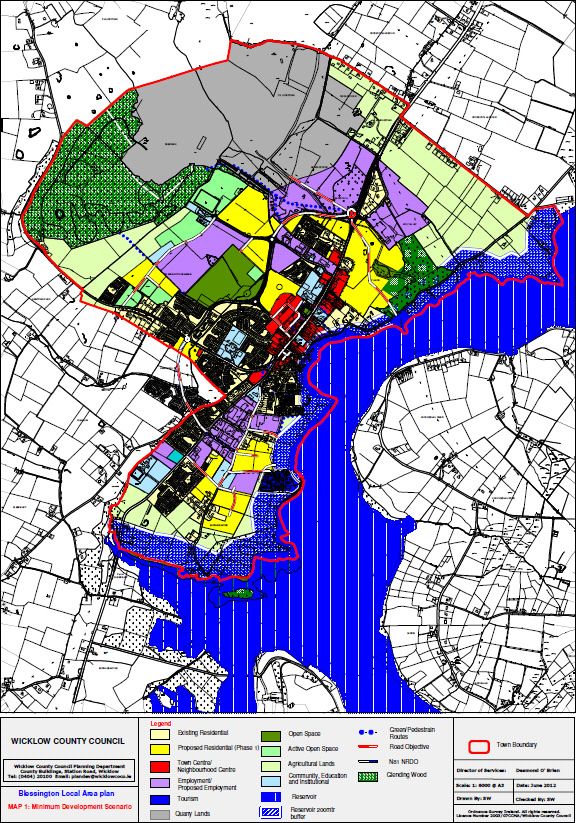
Changes made to the proposed Draft Plan were evaluated for their environmental
consequences and the Environmental Report was updated to become the final Environmental
Report.

The Draft Plan and the associated Environmental Report were placed on public display in 20th
of August 2013. Addendum I to the Environmental Report (which details responses to the
submissions on the Environmental Report which were made during the first period of public
display of the Draft Plan and the Environmental Report) was included in the Manager’s Report
circulated to Elected Members. Addendum I proposed updates to the Environmental Report
as a result of submissions, as appropriate.

Proposed Amendments to the Draft Plan were evaluated for their environmental
consequences. On assessment the proposed amendments were not considered to be
material and therefore no further public display period was required.

On adoption of the Draft Plan, the Addendum 1 was used to update the original
Environmental Report into a final Environmental Report, which accompanies the adopted
Plan.

At each stage of the process the Elected Members took into account the findings of the
Environmental Report and/or the Addenda as appropriate.

                   SEA Statement to the Blessington Local Area Plan 2013 - 2019                2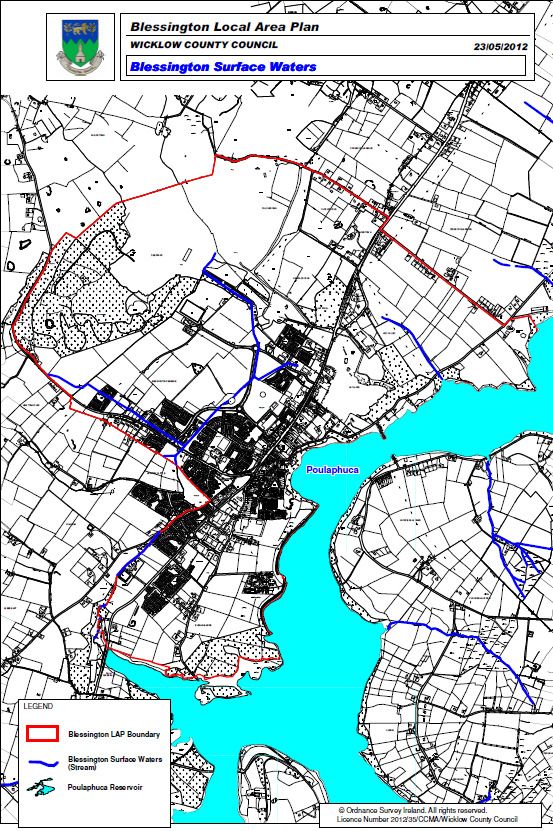
Section 2 How Environmental Considerations were integrated into the Plan
2.1 Consultations
The Environmental Protection Agency (EPA), the Department of the Environment, Community
and Local Government (DECLG), the Department of Communications, Energy and Natural
Resources (DCENR), the Department of Agriculture, Fisheries and Food and the Department
of the Arts Heritage and the Gaeltacht and Kildare County Council were all sent a preliminary
SEA scoping report indicating that submissions or observations in relation to the scope and
level of detail of the information to be included in the environmental report could be made to
Wicklow County Council. Written submissions were then received on the scope of the SEA
from the EPA and the Department of the Arts Heritage and the Gaeltacht only.
Further information on the aforementioned submissions is provided under Section 3.2.
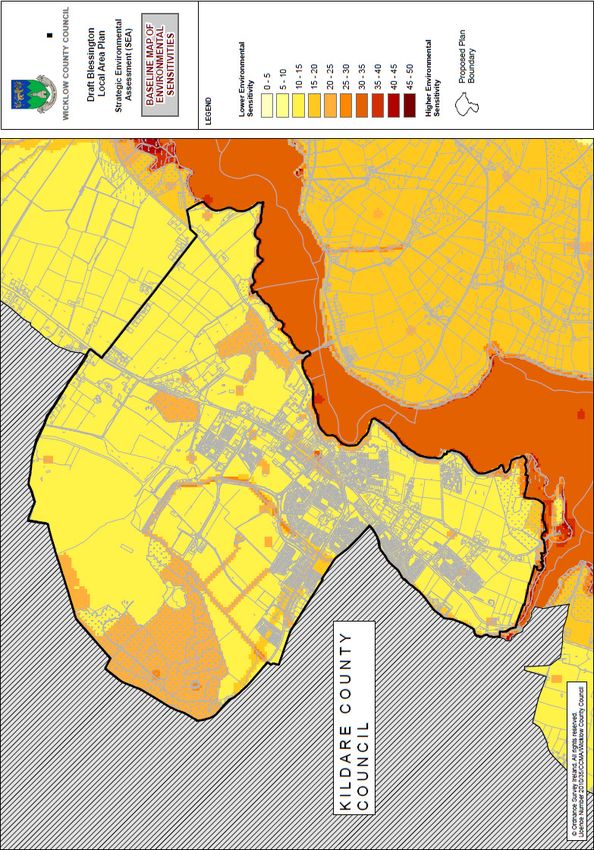
2.2 Environmental Sensitivities
2.2.1 Mapping and Early Communication
Environmental considerations were integrated into the Draft Plan before it was placed on
public display for the first time. Environmental sensitivities were mapped in order to identify
which areas of the plan area would be most sensitive to development and would suffer the
most adverse effects if future development was to be accommodated in those areas
unmitigated.
The sensitivities were communicated to the Plan-making team on a regular basis from the
outset of the Plan preparation process. Identifying areas with the most limited carrying
capacity within the Plan area helped future growth to be diverted away from these areas.
A sample of the sensitivities considered by the SEA included the following:
• Designated ecological sites;
• Land cover;
• Soil Type;
• Water Framework Directive (WFD) Risk Assessments for Rivers, Lakes, Ground, Coastal
and Transitional Waters;
• WFD Register of Protected Areas;
• EPA River Water Quality Monitoring;
• GSI Aquifer Vulnerability and Productivity;
• Flooding Data;
• Waste Water Treatment capacity and demand;
• Drinking water supply;
• Drinking water quality;
• Archaeological Heritage;
• Architectural Heritage;
• Landscape Character Areas; and,
• Protected Views and Prospects.
SEA Statement to the Blessington Local Area Plan 2013 - 2019 3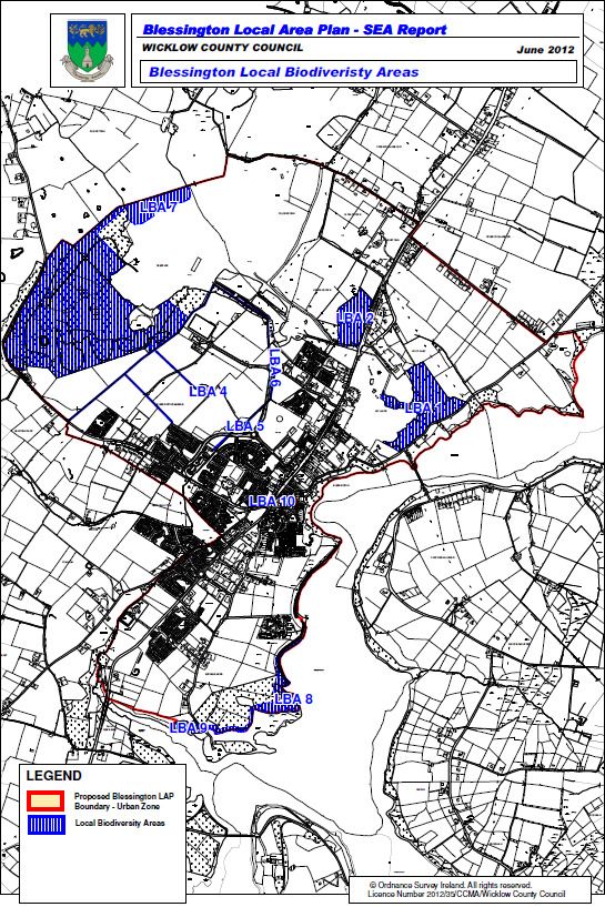
2.2.2 Overlay mapping

A Geographical Information System (GIS) was used in order to weight the above sensitivities
and map them overlapping each other - this allowed the identification of where most
sensitivities occur. Figures 2.5 (a & b) show the overlay map of sensitivities that was used by
the SEA.

Environmental sensitivities are indicated by colours, which range from low environmental
sensitivity (light yellow) to high environmental sensitivity (red). Where the mapping shows a
concentration of environmental sensitivities there is an increased likelihood that development
will conflict with these sensitivities and cause environmental deterioration.

2.3 Early Identification and Evaluation of Alternatives

A range of potential alternative scenarios for the future development of the plan area were
identified at an early stage in the process and evaluated for their likely significant
environmental effects (see sections 6 & 7 of the ER).

The environmental sensitivities and overlay mapping shown in Figures 2.1 to 2.4 were used in
order to predict and evaluate the environmental effects of implementing the scenarios.

Communication of the findings of this evaluation helped the Plan-making team to make an
informed choice as to which alternative was to be put before the Elected Members as the
proposed Plan.

Communication of this evaluation to the Elected Members through the Environmental Report
helped the Elected Members to make an informed choice with regard to the making of the
Development Plan.

Mitigation measures which arose from the evaluation and which were integrated into the Plan
are detailed under Section 2.4 of this report.

                    SEA Statement to the Blessington Local Area Plan 2013 - 2019                  4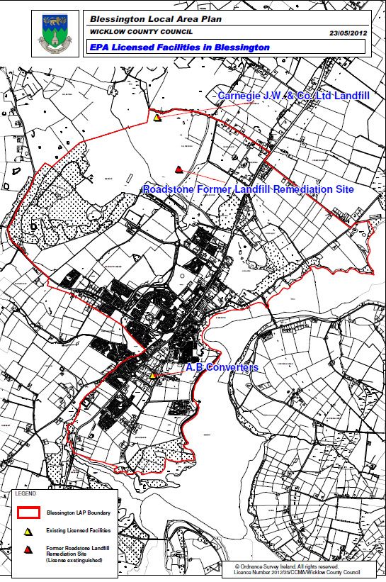
Proposed Blessington Plan Area Local Biodiversity Areas
111 - Continuous Urban 512 – Water Bodies
312 – Coniferous Forest 121 –
231 – Pastures 321 – Transitional
Corine Land Cover Mapping
Figure 2.1 Environmental Sensitivities - 1
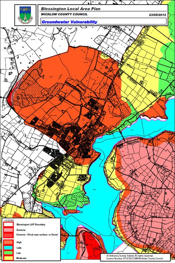
SEA Statement to the Blessington Local Area Plan 2013 - 2019 5Quaternary Geology Areas of Geological and Geomorphological
interest
Blessington Subsoils Groundwater Risk Assessment
Figure 2.2 Environmental Sensitivities - 2
SEA Statement to the Blessington Local Area Plan 2013 - 2019 6Blessington Surface Waters Groundwater Vulnerability
EPA Licensed Facilities CDP Landscape Categorisation
Figure 2.3 Environmental Sensitivities
Sensitivities - 3
SEA Statement to the Blessington Local Area Plan 2013 - 2019 7Protected Structures and Architectural Recorded Monuments
Monuments
Conservation Area
Figure 2.4 Environmental Sensitivities - 4
SEA Statement to the Blessington Local Area Plan 2013 - 2019 8Land with no environmental Land with Surface Water Land with SPA weighting
weighting Status Weighting (5) (10)
Land with pNHA weighting Land with Landscape category
(8) weighting Area of Outstanding
Natural Beauty (9)
Once weightings have been added for these lands a total sensitivity
score of 32 is reached = Highly Sensitive
Figure 2.5 (a) Sample of Overlay Mapping to derive overall Environmental sensitivity
SEA Statement to the Blessington Local Area Plan 2013 - 2019 9Figure 2.5 (b
(b)
Overlay Mapping to
derive overall
Environmental
sensitivity
SEA Statement to the Blessington Local Area Plan 2013 - 2019 102.4 Mitigation
2.4.1 Introduction
In order to comply with various statutory requirements and in order to comply with the
1
requirements of the statutory consultees, mitigation measures were recommended to be
integrated into the Plan.
As the Blessington Local Area Plan must conform to the policies and objectives of the
Wicklow County Development Plan (CDP) 2010 - 2016 the plan does not include a repetition
of the policies, objectives or strategies as set out in the CDP. Where standards or objectives
for a particular development are not included in the Local Area Plan, the provisions of the
CDP are to apply.
Taking this into consideration there are a wide range of mitigation measures/objectives within
the County Development Plan that are applicable to Blessington.
The wide range of topics these mitigation measures cover include:
• Designated Ecological Sites
• Ecological Connectivity
• Human Health
• Brownfield Development
• Status of Surface and Groundwaters
• Flooding
• Water Services (Waste Water and Drinking Water)
• Greenhouse gas emissions and car dependency
• Archaeological Heritage
• Architectural Heritage
• Landscape
Mitigation measures generally benefit multiple environmental components i.e. a measure
providing for the protection of surface water resources could beneficially impact upon the
protection of biodiversity, flora and fauna, drinking water resources, human health and
provision of appropriate waste water treatment infrastructure.
The mitigation measures are identified in Section 9 of the Environmental Report and this
identification is reproduced in Table 2.1 (a & b) below. The reference codes identified are
those which accompany the relevant measures in both the Plan and Section 8 of the
Environmental Report. As set out above, As the Blessington Local Area Plan must conform to
the policies and objectives of the Wicklow County Development Plan (CDP) 2010 – 2016
Table 2.1 (a) also provides a brief breakdown of the relevant mitigation measures contained
in the County Development Plan 2010 – 2016.
1
Mitigation measures are measures envisaged to prevent, reduce and, as fully as possible, offset any
significant adverse impacts on the environment of implementing a human action, be it a plan,
programme or project. Mitigation measures can be roughly divided into those that: prevent effects;
reduce the magnitude or extent, probability and/or severity of effect; repair effects after they have
occurred, and; compensate for effects, balancing out negative impacts with other positive ones. Where
there are likely to be significant negative effects, consideration should be given in the first instance to
preventing these effects or, where this is not possible, to reducing the effects.
SEA Statement to the Blessington Local Area Plan 2013 - 2019 11Mitigation Measure Topic Objectives of the Blessington Local Area Plan
Biodiversity Flora and Fauna BD1, BD2, BD3, BD4, BD5, BD7, BD8, BD9, AA1, AA2, AA3, AA4
Water S1, S2, S3, S4, S5
Soil S1, S2, S3, S4,
Landscape S1,
Air and Climatic Factors S1, E2
Archaeological Heritage S1, BD4, AA1, AA2, AA3, AA4
Architectural Heritage S1, BD7, BD8, BD9, AA1, AA2, AA3, AA4
Transport TC2
Waste Management S1,
Table 2.1 (a) Blessington Specific Mitigation Objectives.
The following sets out relevant objectives of the Wicklow County Development Plan 2010 –
2016 that would be applicable to the Blessington Local Area Plan. Table 2.1 (b) below
provides an extract of the measures integrated into the County Development Plan as
mitigation measures.
WW2 of Chapter 12 of CDP 2010-2016: “To ensure that all foul water generated is collected
and discharged after treatment in a safe and sustainable manner, having regard to the
standards and requirements set out in EU and national legislation and guidance documents.
The Planning Authority will continue to monitor the cumulative effect of grants of planning
permission on available waste water treatment capacity under the terms of the relevant Waste
Water Discharge Licence. Where there is inadequate capacity within a Waste Water
Treatment Plant to accommodate new development or where the Waste Water Treatment
Plant does not meet the terms of the relevant Waste Water Discharge License to the Planning
Authority will:
(a) Refuse planning permission for the development, or
(b) Consider granting permission with conditions limiting the commencement of development
until facilities are suitably upgraded, so long as this is planned to occur within a reasonable
timeframe (not more than 3 years) in accordance with the Local Authority’s Water Services
Investment Programme.”
WT1 of Chapter 17 of CDP 2010-2016: “To implement the EU Water Framework Directive
and associated River Basin and Sub-Basin Management Plans and the EU Groundwater
Directive to ensure the protection, improvement and sustainable use of all waters in the
County, including rivers, lakes, ground water, coastal and estuarine waters, and to restrict
development likely to lead to a deterioration in water quality.”
WT3 of Chapter 17 of CDP 2010-2016: “To prevent development that would pollute water
bodies and in particular, to regulate the installation of effluent disposal systems in the vicinity
of water bodies that provide drinking water or development that would exacerbate existing
underlying water contamination.”
WT4 of Chapter 17 of CDP 2010-2016: “To minimise alterations or interference with
river/stream beds, banks and channels, except for reasons of overriding public health and
safety (e.g. to reduce risk of flooding); a buffer of 10m along watercourses should be provided
free of built development, with riparian vegetation generally being retained in as natural a
state as possible. In all cases where works are being carried out, to have regard to Regional
Fisheries Board ‘Requirements for the protection of fisheries habitat during the construction
and development works at river sites’.”
FL7 of Chapter 12 of CDP: “To require all new developments to include proposals to deal with
rain and surface water collected on site and where deemed necessary, to integrate
attenuation and SUDS measures.”
FL9 of Chapter 12 of CDP 2010-2016: “For developments adjacent to all watercourses of a
significant conveyance capacity or where it is necessary to maintain the ecological or
environmental quality of the watercourse, any structures (including hard landscaping) must be
SEA Statement to the Blessington Local Area Plan 2013 - 2019 12set back from the edge of the watercourse to allow access for channel
clearing/maintenance/vegetation. A minimum setback of up to 10-15m will be required either
side depending on the width of the watercourse”
Table 2.1 (b) Wicklow County Development Plan SEA mitigation measures (source
table 2.1 SEA Statement of the Wicklow County Development Plan 2010 – 2016)
SEA Statement to the Blessington Local Area Plan 2013 - 2019 13Section 3 Environmental Report and Submissions & Observations
3.1 Introduction
This section details how both the Environmental Report and submissions and observations
made to the planning authority on the Environmental Report and SEA process have been
taken into account during the preparation of the Plan.
3.2 SEA Scoping Submissions
The Environmental Protection Agency (EPA), the Department of the Environment, Community
and Local Government (DECLG), the Department of Communications, Energy and Natural
Resources (DCENR), the Department of Agriculture, Fisheries and Food, the Department of
the Arts Heritage and the Gaeltacht and Kildare County Council (being a bordering authority)
were all sent SEA scoping reports indicating that submissions or observations in relation to
the scope and level of detail of the information to be included in the environmental report
could be made to Wicklow County Council. A written response was received on the scope
from the EPA, the Department of Arts Heritage and Gaeltacht and Kildare County Council.
The following written submissions were received from the Environmental Authorities with
specific reference to the SEA process and the production of the Environmental Report. The
content of these submissions was taken into account in formulating the environmental report.
1) Environmental Protection Agency:
This submission included an SEA Guidance document and SEA Pack to assist in undertaking
an environmental assessment as per the Planning and Development (Strategic Environmental
Assessment) Regulations 2004 (S.I. No. 436 of 2004).
Specific Issues required to be considered:
⇒ Provision of adequate and appropriate critical service infrastructure in advance of
permission for development being considered.
⇒ Protection of designated national and international conservation sites (Poulaphuca
Reservoir SPA, Wicklow Mountains SPA/SAC and Red Bod (SAC) in particular.
⇒ Protection of surface and ground water quality.
General Guidance:
The SEA process Guidance Document was received which included details of environmental
issue which where to be integrated into the Blessington Local Area Plan including:
Water Related Issues, Biodiversity, Air Noise and Climatic Factors, Energy Conservation and
Renewable Energy, Landscape Character Assessment, Geology, Human Health and Quality
of Life, Transportation, Tourism, Infrastructure Planning, Urban Waste Water Discharge
Licensing, Waste Management, Environmental Impact Assessment in relation to SEA.
This submission also included the EPA SEA pack which comprises a combination of
guidance, checklists and reference material for use in the SEA and Plan making process.
2) Department of Arts, Heritage and Local Government:
This submission highlighted the issues of protected species that occur outside designated
sites. The Environmental Report should include species protected under the Wildlife Acts of
1976-2010 which may occur anywhere in the country, and not necessarily inside a designated
area.
SEA Statement to the Blessington Local Area Plan 2013 - 2019 14Reference is also made to the data of the National Parks and Wildlife Service (NPWS) at
www.npws.ie and the data of the National Biodiversity Data Centre at
http://www.biodiversityireland.ie/
Recommend that the preliminary draft mitigation measures listed in the scoping report include
protected species.
3) Kildare County Council
The principle issues raised in this submission in relation to the preparation of the Blessington
Local Area Plan and SEA where listed as follows:
SPA Poulaphouca reservoir
⇒ disturbance or removal of feeding grounds of whooper swans in lands not designated by
the SPA status but integral to the conservation of the species and the SAC due to
recreational activities within and adjacent to the lakes (should be covered in NIS)
⇒ water quality
Red Bog
⇒ Water table vulnerability
⇒ Water quality
3.3 Environmental Report Submissions and Observations:
Addendum I of the Environmental Report dealt with issues raised specifically relating to the
SEA and Appropriate Assessment Screening Report of the Draft Blessington Local Area Plan
2013 - 2019. The EPA was the only SEA consultee that made a follow up submission on the
Draft Plan. This submission raised issues specific to the preparation of the environmental
report and AA screening report.
Section A below provides a summary of the more general issues raised in the EPA
submission. Section B contains details of the more specific issues in relation to the
Environmental Report on the Daft Local Area Plan.
Section A: General Issues raised:
1) The submission makes reference to Annex 1 of Directive 2001/42/EC (SEA Directive) and
schedule 2B of the Planning and Development (Strategic Environmental Assessment) Regulations
2004 (S.I. No. 436 of 2004) for “information to be contained in the Environmental Report”.
2) Welcome the inclusion of a number of issues raised from there previous submission.
3) State that consideration should be given to the inclusion of specific commitment to water
conservation measures in the Plan, as well as aligning with the ERBD Management Plan and its
associated Programme of Measures and the Eastern CFRAMS and associated Plan.
4) Consider that the development of the proposed Action Areas should be developed in a coherent
and consistent manner to ensure that a coordinated approach is adopted and the Policies and
Objectives of the Plan are fully integrated into each area as relevant. The development of these
areas should be carried out in a sustainable manner compliant with the requirement and objectives of
environmental legislation.
5) Highlight the requirement to prepare an SEA statement in accordance with Article 141 of the
Planning and Development Regulations as amended by Article 8 of the SEA regulations.
6) Consider that provisions should be made in the plan to ensure that any proposed land use zoning
or development associated with the plan is not in breach of the requirements of the Water Framework
Directive.
7) Clarification required in regard to which strategic environmental objectives specifically mortgage
for the potential for groundwater and surface water contamination form the abstraction of sand and
gravel.
8) Consider that the plan should seek agreement on an appropriate buffer zone to the Poulaphuca
SEA Statement to the Blessington Local Area Plan 2013 - 2019 15Reservoir with the National Parks and Wildlife Service.
9) Contend that consideration should be given to clarification of the requirements of the EIA and AA
for the proposed completion of the Blessington Inner Relief Road.
10) Consider the plan should include a specific commitment to energy conservation.
11) Consider the plan should include policies/objectives in relation to green infrastructure.
12) Consider that there would be merit in the inclusion of a traffic management plan and Noise Action
Plan.
Section B: Specific Issues raised in relation to the Draft Blessington Local Area Plan and the
Environmental Report:
1) Highlight a typing error in the plan in relation to the objective codes used for population and
housing and services infrastructure
2) Consider a stronger commitment to flood risk mitigation is required and propose a wording change
to objective S3 from “To have Regard” to “ To Fully Implement” as appropriate the provisions of “The
Planning System and Flood Risk Management” Guidelines (DoEHLG 2009) and the Flood Risk
Assessment carried out as part of the plan.
3) Monitoring: Consideration should be given to the inclusion of monitoring frequencies and
monitoring for both positive and negative effects of the plan where they occur. This should also
include the actual departments responsible for collecting, collating and analysing the data.
4) It should be clarified how the full range of environmental effects of the implementation of the plan,
as set out in the SEA Directive and Regulations, (i.e. “secondary, cumulative, synergistic, short,
medium and long–term, permanent and temporary, positive and negative effects”), have been
assessed and documented. In particular, you are referred to potential cumulative effects / in-
combination effects in relation to other plans / programmes / strategies / projects.
5) Waste Water and Infrastructure: The plan should promote as appropriate specific provisions for
the implementation of the relevant recommendations set out in the recent Focus on Urban Waste
Water Discharges in Ireland report (EPA 2012)
Zoning within the plan should be linked to the availability of and adequacy of water supply and waste
water infrastructure.
6) Waste Management: The plan should promote the integration of land use zoning and development
to existing and planned availability of waste infrastructure and capacity.
7) The plan should provide for adequate buffers between designated sites and areas zoned for
development. This should be carried out in consultation with the NPWS.
8) The plan should make reference to and promote the implementation of the Noise Directive
9) The plan should include objectives in relation to the preparation of an Energy Conservation
Strategy.
10) The plan should promote and as appropriate provide the provision of sustainable modes of
transport.
11) The plan should highlight that under EIA and Planning and Development Regulations certain
projects that may arise during the implementation of the plan may require EIA.
12) The plan should ensure relevant policies and objectives are included to address where
appropriate the “Environmental Challenges and Priorities” for Ireland as set out in Chapter 10 of the
EPA Irelands Environment 2012.
The information contained in this submission was taken into account by the SEA as well as
the Appropriate Assessment, which was undertaken for the Plan. The following updates to the
Environmental Reports were identified following the public display period:
SEA Statement to the Blessington Local Area Plan 2013 - 2019 161) Insert the following wording at the end of Section 10.5 Reporting:
Indicators, targets and corrective and remedial actions will be reviewed during the
preparation of the preliminary monitoring evaluation report.
2) Insert the following wording at the end of the 1st paragraph of Section 7.2
The interactions between the SEOs and the alternatives determine the likely significant effects
of implementing the Plan. These effects include secondary, cumulative, synergistic, short,
medium and long-term permanent and temporary, positive and negative effects.
3) Insert the following wording in Section 8.1:
This section evaluates the Draft Plan provisions. Strategic Environmental Objectives (SEOs)
are used for this purpose as outlined under Section 7.2 Use has also been made of the
environmental baseline descriptions and the maps of the individual environmental
components and the overlay of environmental sensitivities provided in Section 3.
The interactions between the SEOs and the provisions of the Plan determine the likely
significant effects of implementing the Plan. These effects include secondary, cumulative,
synergistic, short, medium and long-term permanent and temporary, positive and negative
effects.
3.4 The Environmental Report:
The findings of the SEA were expressed in an Environmental Report, which was submitted to
the Elected Members alongside the proposed Draft Plan. The purpose of the report was to
provide a clear understanding of the likely environmental consequences of decisions
regarding the future development of Blessington.
Addendum I to the Environmental Report (which details responses to the submissions on the
Environmental Report which were made during the first period of public display of the Draft
Plan and the Environmental Report) was included alongside the Manager’s Report circulated
to Elected Members. Addendum I proposed updates to the Environmental Report as a result
of submissions, as set out above.
Proposed Amendments to the Draft Plan were evaluated for their environmental
consequences. The proposed amendments where not considered to be significant and the
plan was adopted at the Council meeting on the 03/12/12.
On adoption of the Draft Plan, Addendum 1 was used to update the original Environmental
Report into a final Environmental Report, which accompanies the adopted Plan.
At each stage of the process the Elected Members took into account the findings of the
Environmental Report and/or the Addendum as appropriate.
SEA Statement to the Blessington Local Area Plan 2013 - 2019 17Section 4 Alternative Plan Scenarios Considered
4.1 Introduction
This section describes the alternative scenarios considered for the Draft Local Area Plan,
summarises the evaluation for likely significant environmental effects of each scenario which
is provided in the Environmental Report and identifies the reasons for choosing the Plan, as
adopted, in the light of the other reasonable alternatives dealt with.
4.2 Description of the Alternative Scenarios
The environmental consequences of 3 alternative scenarios for the Plan were examined.
4.2.1 Scenario 1 Minimal Development Envelope
Scenario 1 Minimal Development Envelope
Characteristics of this scenario as set out in figure 4.1 provide for an extensive 200m buffer
zone inland from the shoreline of the Poulaphuca Reservoir and designation of lands within
this zone for agricultural purposes only, the expansion of Glen Ding Wood and designation as
a conservation zone onto lands currently in use as forestry/remediated from quarrying
activities within this area. This scenario places a strong emphasis on the protection of locally
important Biodiversity sites and ecological networks.
This plan also places a strong emphasis on the protection of the Architectural Conservation
Area within the town centre and the provision of increased pedestrian movements by
improving access between areas of natural and built conservation value.
In addition to the above measures, this scenario places a strict emphasis on the development
of lands only where existing infrastructure is adequate to cater for such development.
This plan scenario contains the following specific local objectives:
Local Objective 1 – To provide for a 200m buffer along the lakeshore of the Poulaphuca
Reservoir and restrict lands within this zone to agricultural or conservation and amenity uses
only.
Local Objective 2 – To protect existing ecological linkages and Local Biodiversity areas
within the plan area.
Local Objective 3 - Provision of a conservation and amenity zoning at Glen Ding Wood, to
the east of the plan area adjacent to and forming part of Doran’s Pit.
Local Objective 4 – Provision of a new amenity park and employment zone at Roadstone to
the north of the town, promoting the conservation and enhancement of existing lands.
Local Objective 5 – Strict monitoring of existing and future quarry activities
SEA Statement to the Blessington Local Area Plan 2013 - 2019 18Figure 4.1 –Scenario 1 – Minimal Development Envelope
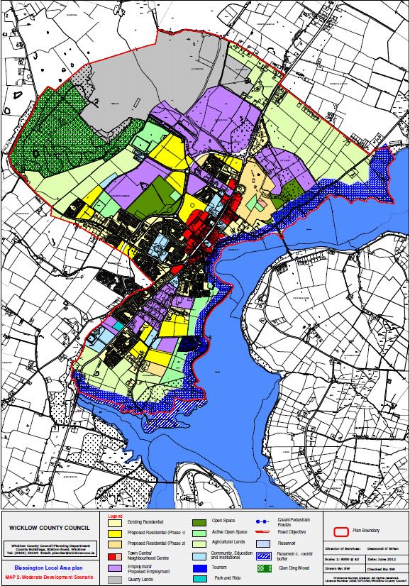
SEA Statement to the Blessington Local Area Plan 2013 - 2019 194.2.2 Scenario 2 Moderate Development Envelope
Scenario 2 Moderate Development Envelope
Characteristics of this scenario are similar to scenario 1 with the following exceptions;
1. The 200m buffer along the Poulaphuca Reservoir has been reduced to 100m Buffer zone
with agricultural zonings within this area.
2. This plan scenario provides a further c. 60 - 100m of lower order uses adjacent to the
buffer zone detailed in scenario 1 above in the form of extensive Active Open Space lands as
a further measure aimed at preventing any impacts on the pNHA and designated SPA.
3. A slightly reduced open space and amenity park zone has been provided to the north east
of the plan area in recognition of the findings of the local biodiversity study carried out and
from on the ground site inspections. The emphasis of this reduced zoning being the protection
of the more extensive and fully established areas of woodland in this area with the more
unestablished portion being rezoned as an expanded employment zoning.
4. The provision of a larger employment zoning area at Roadstone to the northwest of the
town centre providing for a lower density employment development and with the increased
lands forming a new amenity park area linked to Glending Woods by pedestrian walks.
5. A recognition of the existing permissions for quarrying activities at Glen Ding with all
remaining lands forming part of the Woodland Conservation Zone.
6. The provision of residentially zoned lands adjacent to the Blessington Stream, provided for
through the justification test.
The scenario includes the following local objectives:
Local Objective 1 – To provide for a 100m buffer along the lakeshore of the Poulaphuca
Reservoir and restrict lands within this zone to agricultural or conservation and amenity uses
only.
Local Objective 2 - Provision of conservation zones at Glen Ding, Burgage Mor and adjacent
to Doran Pit.
Local Objective 3 - To protect existing ecological linkages and Local Bio-diversity areas
within the plan area.
Local Objective 4 - Provision of a new large amenity park and employment zone at
Roadstone to the north of the town, promoting the conservation and enhancement of existing
lands and linkages to Glen Ding Wood.
Local Objective 5 – Strict monitoring of existing and future quarry activities.
SEA Statement to the Blessington Local Area Plan 2013 - 2019 20Figure 4.2 –Scenario 2 – Moderate Development Envelope
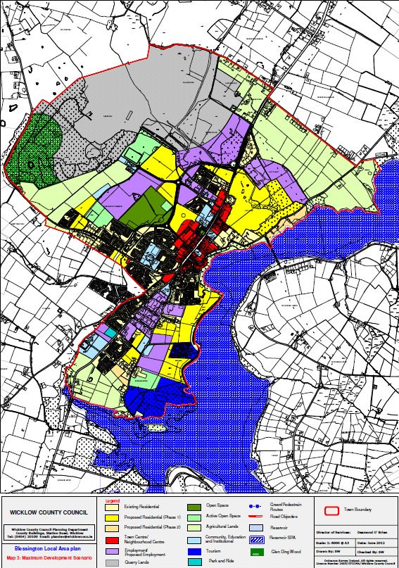
SEA Statement to the Blessington Local Area Plan 2013 - 2019 214.2.3 Scenario 3 Maximum Development Envelope
This scenario (see figure 4.3) represents a further intensification development and associated
impacts set out in scenario 2 with the further encroachment of development into virgin/rural
lands to the north and south and east of the plan area. This scenario provides for extensive
zonings maximising the development potential and views along the lakeshore with a limited
distance between these zonings and the pNHA and SPA.
This scenario aims to maximise the development potential along the lakeshore with the
provision of a large area being zoned to provide for a new integrated tourism and leisure
facility at Burgage Mor further maximising the tourism potential of the lake.
This scenario also provides for an expansion of existing quarrying activities into Glen Ding
Woods providing for a minimal buffer between this area and the listed recorded monuments
within this zoning.
A low density residential zoning is provided along the lakeshore to the north east allowing for
the provision of single housing overlooking the reservoir. A more dense employment zone is
also provided for along the N81 to the north west of the town on lands owned by Roadstone
with this plan having little or no regard to the findings of the Local Biodiversity study.
The scenario includes the following local objectives:
Local Objectives 1 – Provision of extensive residential development along the Lakeshore
with little or no provision for a buffer zone to the Poulaphuca Reservoir.
Local Objective 2 – Provision of an Integrated Tourism and Leisure development at Burgage
Mor to the south of the town maximizing the tourism potential of the lake.
Local Objective 3 – Provision of low-density residential development with individual
wastewater treatment facilities along the lakeshore and within lands zoned for agricultural
lands.
Local Objective 4 – Expansion of existing quarry lands at Roadstone to the north of the
town.
SEA Statement to the Blessington Local Area Plan 2013 - 2019 22Figure 4.3 –Scenario 3 – Maximum Development Envelope
SEA Statement to the Blessington Local Area Plan 2013 - 2019 234.3 Evaluation of Alternative Plan Scenarios
4.3.1 Methodology
4.3.1.1 Existing Environment and Overlay Mapping
In order to identify the extent to which environmental sensitivities are likely to be impacted
upon by implementation of the 3 scenarios, use was made of environmental baseline data
and overlay mapping (see Figures 2.1 to 2.4 of this report).
4.3.1.2 Strategic Environmental Objectives (SEOs)
Based on an understanding of the existing and emerging environmental conditions in the
Blessington area a series of Strategic Environmental Objectives (SEOs) were identified and
developed in order to assess the likely environmental effects which would be caused by
implementation of each of the 3 alternative scenarios described above.
The alternatives are evaluated using compatibility criteria (see Table 4.1) in order to
determine how they are likely to affect the status of these SEOs.
Table 4.2 brings together all the SEOs, which have been developed from international,
national and regional policies, which generally govern environmental protection objectives.
The SEOs and the alternative scenarios are arrayed against each other to identify which
interactions - if any - would cause impacts on specific components of the environment. Where
the appraisal identifies a likely conflict with the status of an SEO the relevant SEO code is
entered into the conflict column - e.g. B1 which stands for SEO likely to be affected - in this
instance ‘To ensure compliance with the Habitats Directive and National Biodiversity Plan with
regard to protected species and habitats both within and outside of designated sites in
accordance with the provisions of Articles 6 and 10 of the Habitats Directive’.
Likely to Probable Conflict with status Potential Conflict with No Likely
Improve of SEOs unlikely status of SEOs- likely to be interaction
status of to be mitigated mitigated with status of
SEOs SEOs
Table 4.1 above: Criteria for appraising the effect of Plan provisions on Strategic
Environmental Objectives.
SEO B1 To ensure compliance with the Habitats Directive and National Biodiversity Plan with regard to
protected species and habitats both within and outside of designated sites in accordance with the
provisions of Articles 6 and 10 of the Habitats Directive.
SEO B2 To avoid significant adverse impacts, including direct, cumulative and indirect impacts, to relevant
habitats, geological features, species or their sustaining resources in designated ecological sites
such as Poulaphouca Reservoir pNHA and SPA by development adjacent to this site.
SEO B3 To ensure compliance with Article 10 of the Habitats Directive with regard to the management of
features of the landscape – by sustaining, enhancing or - where relevant - preventing the loss of
ecological networks or parts thereof which provide significant connectivity between areas of local
biodiversity
SEO HH1 To protect human health from hazards or nuisances arising from exposure to incompatible land
uses in particular from the re-use of brown field lands in areas where previous uses may have
contaminated lands such as existing quarry lands.
SEO R1 Maximise the sustainable re-use of brownfield lands, and maximise the use of the existing built
environment rather than developing greenfield lands
SEO S1 To prevent pollution and/or contamination of soil within the plan area of Blessington.
SEA Statement to the Blessington Local Area Plan 2013 - 2019 24SEO To maintain and improve, where possible, the quality of Streams, Rivers, Lakes and other surface
Code W-S waters within and adjoining the plan area of Blessington.
Indicators Poor, Sufficient, Good and Excellent classifications of bathing water as set by Directive 2006/7/EC
W-S(2)
SEO To prevent pollution and contamination of ground waters
Code W-
G
SEO To prevent development on lands which pose - or are likely to pose in the future - a significant
Code W-F flood risk
SEO To serve new development with appropriate waste water treatment
Code WW
SEO
Code DW To serve development within the Plan area with drinking water that is both wholesome and clean
SEO ode To reduce travel related greenhouse emissions to air
AQ1
SEO To reduce car dependency within the plan area by way of, inter alia, encouraging
Code modal change from car to more sustainable forms of public transport and
AQ2: encouraging development which will not be dependent on private transport
SEO To protect the archaeological heritage of Blessington including entries to the Record of
Code AH1 Monuments and Places –- and the context of the above within the surrounding landscape where
relevant
SEO To preserve and protect the special interest and character of Blessingtons architectural heritage
Code AH2 including entries to the Record of Protected Structures, and their context within the surrounding
landscape where relevant
SEO To protect and avoid significant adverse impacts on the landscape of Blessington including
Code L1 landscape features such as the Lake Shore and Glen Ding Wood.
Table 4.2: Strategic Environmental Objectives1
1
Strategic Environmental Objectives (SEOs) are methodological measures, which are developed from
international and national policies which generally govern environmental protection objectives and
against which the environmental effects of the Plan were tested. The SEOs are used as standards
against which the provisions of the Plan were evaluated in order to help identify areas in which
significant adverse impacts are likely to occur, if unmitigated against.
SEA Statement to the Blessington Local Area Plan 2013 - 2019 25Figure 4.4 Environmental Sensitivity mapping
SEA Statement to the Blessington Local Area Plan 2013 - 2019 264.3 Evaluation of Plan Scenarios2
4.3.1.2 Introduction
This section summarises where each development scenario is likely to give rise to
environmental impacts within the plan area. Each scenario as set out above in section 4.2
was overlaid on top of the above baseline sensitivity map in figure 4.4 in order to identify the
most likely environmental impacts each varying scenario would have on the plan areas
receiving environment.
4.3.2.2 Alternative Scenario 1 – Minimal Development Envelope
⇒ Likely Environmental Effects
This plan scenario has the least environmental impact – with no new large-scale development
being permitted until such time as adequate wastewater treatment infrastructure is in place.
The scenario provides for extensive buffers along the lakeshore c. 200m, Poulaphuca SPA
and pNHA, a strong recognition of the findings of the Local Biodiversity Study carried out, a
strong protection and expansion of Glen Ding Wood. Strict adherence to the provisions of the
Flood Management Guidelines is also provided for.
The resultant settlement pattern is tightly concentrated around the existing town centre
promoting sustainable patterns of mobility with new zonings also being accompanied by
strong environmental objectives.
4.3.2.3 Alternative Scenario 2 – Moderate Development Envelope
Likely Environmental Effects
This plan scenario bears similarities to Scenario 1 however provides for a more expansive
plan area recognising the extent of existing quarrying permissions obtained by Roadstone, by
reducing the protection buffer along the lakeshore from 200m to 100m and providing for lower
order uses within the 100-200m zone from the lakeshore in the form of Active Open Space
lands. The provision of such spaces while making use of existing agricultural lands facilitates
the expansion of the sporting and open space needs of the town while also protecting the
natural environment of these areas and providing a further buffer from further residential and
employment development.
This scenario provides for a relatively compact layout with the exception of the appearance of
the extensive employment zoning to the north west of the plan area. While the appearance of
this zone may seem quite large the provisions of this employment zoning only allow for
development at a plot ratio of 0.1 with the remaining lands being development as open space
and amenity parkland capable of providing connectivity to Glen Ding Wood and maintaining
the existing Local Biodiversity areas and linkages in this area.
Failure to provide waste water treatment infrastructure and capacity in line with population
growth would be likely to result in significant adverse impacts upon surface waters at risk of
not meeting objectives under the Water Framework directive, thereby impacting upon
biodiversity and flora, fauna and upon human health. This plan scenario also has a strict
policy of no new large-scale development being permitted until such time as adequate
wastewater treatment infrastructure is in place.
2
Footnotes like this are used in this section in order to identify instances where interactions between the
relevant Scenario and the relevant SEOs occur. The nature of these interactions is identified on Table
7.2 of the ER.
SEA Statement to the Blessington Local Area Plan 2013 - 2019 274.3.2.4 Alternative Scenario 3 – Maximum Development Envelope
Likely Environmental Effects
This scenario provides for a significant development for residential and tourism purposes
along the lakeshore in close proximity to the designated SPA and pNHA. This scenario has
little recognition of the Local Biodiversity areas identified in the Biodiversity study carried out
and also facilitates an expansion of quarrying activities into Glen Ding Wood with a minimalist
approach towards protecting the listed national monuments located in this area.
The provision of single one off housing along the lakeshore is also a feature of this scenario
maximising the scenic value of the lakeshore and views of the Wicklow Mountains. Little or no
protection is provided for the identified water and wildlife corridors as set out in the Local
Biodiversity mapping and the provision of significant residential, employment development is
prioritised over the locating of community and open space needs of the plan area.
As is the case with Scenario 1 and Scenario 2, failure to provide waste water treatment
infrastructure and capacity in line with population growth would be likely to result in significant
adverse impacts upon surface waters already at significant risk of not meeting objectives
under the Water Framework development, upon biodiversity and flora and fauna and upon
human health.
SEA Statement to the Blessington Local Area Plan 2013 - 2019 284.3.2.5 Evaluation against SEOs
Table 4.3 below provides an evaluation of each of the alternative development scenarios for the Draft Plan against the Strategic Environmental Objectives
(SEOs).
No Likely
Probable Conflict with status of SEOs Potential Conflict with status of SEOs- likely
Likely to Improve status of SEOs interaction with
unlikely to be mitigated to be mitigated
status of SEOs
B1, B2, B3, HH1, R1, W-S, W-G, W-F, WW, AH1, AH2 (Consolidation of existing town centre
DW, AH1, AH2, L1 (Protection of various may conflict with Archaeological and
environmental components resulting from Architectural Heritage),
minimising greenfield development). HH1, (Regeneration of potentially contaminated
Scenario AQ1, AQ2, (reducing travel emissions, energy lands within the Employment/former quarry
1 usage and encouraging sustainable mobility) zone)
WW, (strictly no development unless adequate B1, B2, B3, R1, W-S, W-G, W-F, WW, DW, L1
WWT in place) (Conflicts with various environmental
components and projects will have to be
mitigated)
B1, B2, B3 (strict protection of cSPA & pNHA AQ1, AQ2, (Expansion of development B1, R1, W-S, W-G, W-F, WW, DW, L1, AH1,
and ecological corridors) boundary will lead to increases in travel AH2 (Reduced protection of various
WW, (strictly no development unless adequate related emissions, energy usage) environmental components resulting from
WWT in place) B3 (due to direct impacts as a result of increasing impingement onto greenfield lands).
Scenario
HH1, R1, W-S, W-G, W-F, DW, AH1, AH2, L1 greenfield development)
2
(Protection of various environmental HH1, (Regeneration of potentially contaminated
components resulting from minimising greenfield lands within employment/former quarry lands)
development).
AQ1, AQ2, (Expansion of development B1, R2, W-S, W-G, W-F, DW, AH1, AH2,
boundary will lead to increases in travel (Reduced protection of various environmental
related emissions, energy usage) components resulting from increasing
Scenario B2, B3, L1 (reduced protection of cSPA impingement onto greenfield lands).
3 and pNHA and due to direct impacts as a
result of greenfield development) HH1, (Regeneration of potentially contaminated
WW, (allowance for individual WWTP to lands within employment/former quarry lands)
serve new developments)
SEA Statement to the Blessington Local Area Plan 2013 - 2019 294.4. Reasons for choosing the Plan in light of the other reasonable alternatives dealt
with
The measurements indicate the following:
⇒ Scenario three would be likely to result in more adverse environmental impacts than each
of the other two Scenarios.
⇒ If mitigated, Scenarios 1 and 2 would be likely to result in a lesser frequency and
magnitude of impacts than Scenario 3.
⇒ Scenario 3 is the scenario with the greatest amount of high and acute vulnerability areas
covered by development pressure areas and the only scenario for which extremely
vulnerable areas are covered by development pressure areas.
The preferred Alternative:
On the basis of the above analysis Scenario 1 would be likely to improve the status of a
number of the SEOs and emerges as the most environmentally sustainable option. If
unmitigated, Scenarios 2 and 3 would be likely to result in a number of adverse environmental
impacts. Having regard to planning considerations, Scenario 2 provides a better balance
between environmental protection and economic and social development and therefore
provides for the most overall sustainable option. Under Scenario 2, potential conflicts with
environmental objectives can largely be offset by appropriate mitigation measures.
The key areas identified as requiring mitigation relate to lands adjoining the lakeshore, lands
zoned for Quarrying and Employment to the north of west of the plan, the existing ecological
corridors formed by the Blessington Stream, Local Biodiversity Areas within the plan area, the
town centre area which includes the Architectural Conservation Area and the existing
protected buildings structures and monuments within this area.
The Local Area Plan for Blessington: The Local Area Plan that has emerged from the Plan
preparation corresponds most closely to Scenario 2.
SEA Statement to the Blessington Local Area Plan 2013 - 2019 30Section 5 Monitoring Measures
5.1 Introduction
The SEA Directive requires that the significant environmental effects of the implementation of
plans and programmes are monitored. This section and section 10 of the environmental
report puts forward proposals for monitoring the Local Area Plan, which are adopted
alongside the Local Area Plan. Monitoring enables, at an early stage, the identification of
unforeseen adverse effects and the undertaking of appropriate remedial action.
In addition to this, monitoring can also play an important role in assessing whether the LAP is
achieving its environmental objectives and targets - measures which the LAP can help work
towards - whether these need to be re-examined and whether the proposed mitigation
measures are being implemented.
5. 2 Indicators and Targets
Monitoring is based around the indicators, which were chosen earlier in the process. These
indicators allow quantitative measures of trends and progress over time relating to the
Strategic Environmental Objectives used in the evaluation. Focus will be given to indicators
which are relevant to the likely significant environmental effects of implementing the Local
Area Plan and primarily to existing monitoring arrangements in order to monitor the selected
indicators. Each indicator to be monitored will be accompanied by the relevant target(s) -
measures which the Local Area Plan can help work towards - which were identified with
regard to the relevant legislation. The table below shows the indicators and targets, which
have been selected with regard to the monitoring of the plan.
5.3 Sources
In compliance with the SEA Directive and the DECLG Guidelines, measurements for
indicators come from existing monitoring sources and no new monitoring should be required
to take place. Existing monitoring sources exist for many of the indicators and include those
maintained by Wicklow County Council and the relevant authorities e.g. the Environmental
Protection Agency, the National Parks and Wildlife Service and the Central Statistics Office.
The Development Management Process in Wicklow County Council will provide additional
monitoring of certain indicators and targets on an application-by-application basis. Where
significant adverse effects - including positive, negative, cumulative and indirect - are likely to
occur upon, for example, entries to the Record Monuments and Places, entries to the Record
of Protected Structures or ecological networks as a result of the undertaking of individual
projects or multiple individual projects such instances will be identified and recorded and will
feed into the monitoring evaluation.
5.4 Excluded Indicators and Targets
As noted on Table 5.1 below, future-monitoring data for Indicators AQ1 (Percentage of
population within the County travelling to work or school by public transport or non-
mechanical means) and AQ2 (Average distance travelled to work or school by the population
of the County) will be based around data from the results of the 2011 CSO Census POWCAR
data. It is recommended that this recently published data be used as a baseline indicator for
the SEA of the next review of the Plan.
5.5 Reporting
The ongoing monitoring of the Blessington Local Area Plan and its implications on the
environment is paramount to ensure that the environment of the Plan area and zone of
influence is not adversely affected by the implementation of the Plan.
SEA Statement to the Blessington Local Area Plan 2013 - 2019 31You can also read