Northumbria river basin district Flood Risk Management Plan 2015 to 2021 Habitats Regulation Assessment - March 2016 - Gov.uk
←
→
Page content transcription
If your browser does not render page correctly, please read the page content below
Northumbria river basin district
Flood Risk Management Plan 2015
to 2021
Habitats Regulation Assessment

March 2016

                  1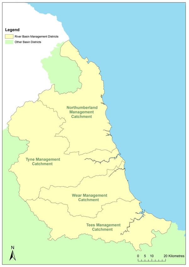
Executive summary
The Flood Risk Management Plan (FRMP) for the Northumbria River Basin District (RBD)
provides an overview of the range of flood risks from different sources across the 4
catchments of the RBD. The RBD catchments are defined in the River Basin Management
Plan (RBMP) and based on the natural configuration of bodies of water (rivers, estuaries,
lakes etc.).

The range of measures in the Northumbria RBD FRMP are reported under the following
types of flood management action:

Types of flood management measures                                             % of RBD measures

Prevention – e.g. land use policy, relocating people at risk etc.                                23%
Protection – e.g. various forms of asset or property-based protection                            36%
Preparedness – e.g. awareness raising, forecasting and warnings                                  40%
Recovery and review – e.g. the ‘after care’ from flood events                                     1%
Other – any actions not able to be categorised yet                                              None

The purpose of the HRA is to report on the likely effects of the FRMP on the network of sites
that are internationally designated for nature conservation (European sites), and the HRA
has been carried out at the level of detail of the plan. Many measures do not have any
expected physical effects on the ground, and have been screened out of consideration
including most of the measures under the categories of Prevention, Preparedness, Recovery
and Review. Others that may have effects but are in catchments that do not have any
designated European sites have also been screened out of consideration.

Risk Management Authorities (RMAs) have for a long time been addressing the range of
flood risks through a range of plans and actions. Much of the Northumbria RBD FRMP
presents measures that are ongoing from existing plans, which have already been subject to
HRA. RMAs have considered the effects of these existing plan measures on European sites
in published HRAs where required. These measures, their effects and agreed actions to
mitigate the effects have been summarised under relevant RBD catchments. Where RMAs
have identified new flood risk management priorities for the next FRMP cycle period
between 2015 and 2021, then the measures to implement these have been considered
alongside existing plan measures in this HRA.

The following table summarises the numbers of measures that the HRA has considered:

FRMP RMA plans                        Screened out          Measures from             New cycle 1
                                         measures            existing plans            measures1
Northumbria RBD catchments                   61 (53%)               46 (40%)                  8 (7%)

The HRA has been carried out for the set of measures for each RBD catchment that address
main river, sea and reservoir flooding alongside any measures volunteered by RMAs that

1
  Measures across several catchments are counted up for each catchment for HRA purposes which may be a
different figure than reported in the FRMP.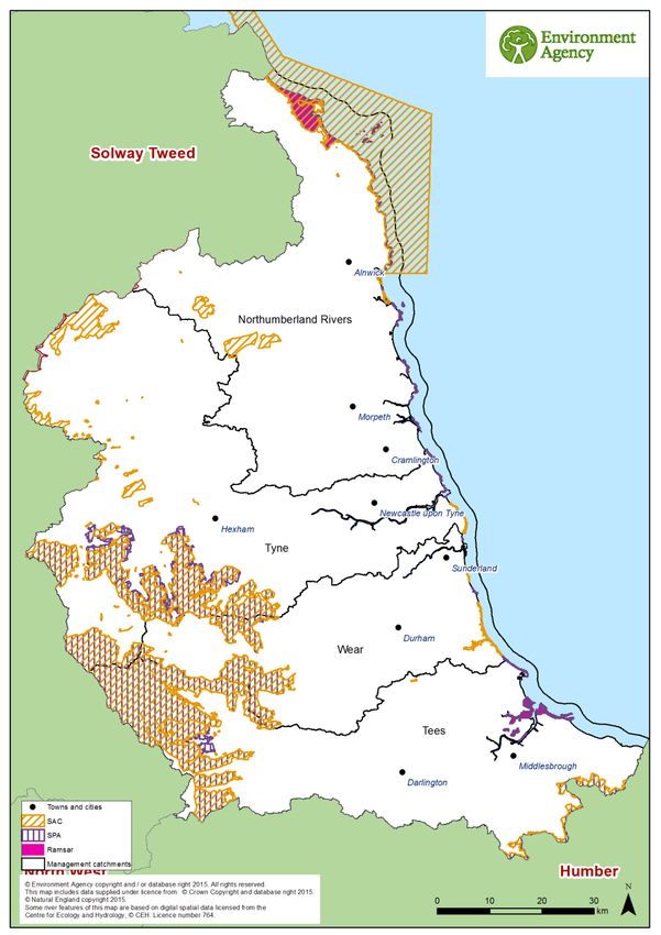
address local flooding and thus form a ‘RBD plan’ within the FRMP. The findings are a
summary of the risks to European sites and an indication of the need for future HRAs at a
project level when developing local actions, as well as considering how to avoid and mitigate
any residual risks to European sites.
For the Northumbria RBD FRMP, the main conclusions from the stages of assessment
across the FRMP are as follows:
A determination was made to screen out measures that would not have physical effects on
any European sites.
The effects of the measures from existing plans include effects of measures to address
main river flooding from CFMPs and measures to address local flooding from local
strategies. Existing controls and mitigation from these plans include more detailed appraisal
and assessment on plans or projects arising out of the plans to demonstrate meeting the
requirements of the Conservation of Habitats and Species Regulations 2010, as amended
(Habitats Regulations)..
The effects of the measures that are for new flood risk management priorities for the next
FRMP cycle period of 2015 to 2021 have been considered within this strategic-plan level
HRA as far as they can be assessed at this high level. This HRA considered the range of
mitigation options that may be applicable. It is concluded that the measures are expected to
be able to be avoided or mitigated as part of their development as local actions, and all
measures have been identified as capable of being fully mitigated. It can therefore be
concluded that at the plan level there is sufficient scope for ensuring no likely significant
effects during its implementation. The detail of the controls and mitigation required will be
assessed as part of requirements to meet consents under planning and other consenting
mechanisms as part of a project level HRA, some of which may need to proceed to
appropriate assessment in order to gather the necessary level of detail.
The HRA considers the potential for in-combination effects with other plans and projects.
Given the level of information currently available, the assessment has identified the plans
where the greatest risk of in-combination effects occur, but a detailed assessment can only
be undertaken at the project level when details of location and design of measures are
known. Key external plans to consider for in-combination effects are:
Local Plans – plans of local planning authorities to determine consent for proposed
developments including FCRM ‘Protection’ types of development and which require
HRA for developments affecting European sites
Water Resource Management Plans – plans to manage the supply of water to
communities by Water Companies.
River Basin Management Plans – plans that seek to ensure the objectives of water
dependent European sites are maintained.
Marine Plans – plans to manage the sustainable use of marine resources for inshore
areas.
This HRA does not remove the need for HRA at a subsequent level, i.e. lower tier strategies,
plans or projects that implement measures. This plan-level HRA does not give any weight to
subsequent lower-tier plans or projects and their HRA outcomes.
As local actions are developed at a project level and the details of their scope and scale are
known, this may identify additional effects on European sites that have not been assessed
here, or were not appropriate to consider at this spatial scale of plan.

CONTENTS

1     Introduction .................................................................................................................... 6
    1.1     Introducing this report ............................................................................................. 6
    1.2     Background to the FRMPs ...................................................................................... 7
    1.3     The Northumbria RBD FRMP ................................................................................. 7
    1.4     Background to Habitats Regulations Assessment ................................................... 9
2     European sites in the Northumbria RBD ...................................................................... 11
    2.1     European sites that could be affected by the FRMP.............................................. 12
    2.2     European sites and their status for FRMPs ........................................................... 12
    2.3     European sites and their management.................................................................. 13
3     Approach to the HRA ................................................................................................... 14
    3.1     Description of the FRMP programmes of measures .............................................. 14
    3.2     Screening and Likely Significant Effects................................................................ 14
    3.3     Screening out catchments where no European sites are present .......................... 15
    3.4     Screening out measures that would not have physical effects .............................. 15
    3.5     Considering measures from existing plans ............................................................ 16
    3.6     Considering new measures for FRMP cycle 1 ....................................................... 16
    3.7     Considering the need for further stages of assessment ........................................ 17
4     Northumbria River Basin District Catchments HRA ...................................................... 18
    4.1     Summary of Measures .......................................................................................... 18
    4.2     Screening and Likely Significant Effects................................................................ 20
    4.3     Consideration of results and conclusion ................................................................ 24
5     In combination effects with other plans and projects .................................................... 28
    5.1     In-combination effects between RBD FRMPs ....................................................... 28
    5.2     In-combination effects with external plans ............................................................. 29
6     Conclusion and Future HRAs ....................................................................................... 31
Annex A:

          Table A1 – HRA screening table for the FRMP measure categories
          Table A2 – Management catchments and European sites in the Northumbria RBD
          Table A3 – Mitigation and control measures
Annex B – Northumbria RBD European sites
1 Introduction
1.1 Introducing this report
This report sets out the results of a strategic- plan level Habitat Regulations Assessment
(HRA) into the likely significant effects on designated ‘European sites’ of the Flood Risk
Management Plan (FRMP) for the Northumbria River Basin District, published in December
2015. The HRA report has been prepared by the Environment Agency on behalf of the
collective Risk Management Authorities (RMAs) that have responsibilities for information
being published within the FRMP, and are thus the ‘competent authorities’ for the HRA of
their respective published information, as follows:
Information on flooding from main river, sea and reservoirs being published for the
catchments of the river basin district (RBD) are the responsibility of the Environment
Agency (for English catchments).
Information on flooding from local sources being published for any Flood Risk Area
(FRA) is the collective responsibility of Lead Local Flood Authorities within the FRA.
In preparing the HRA report the Environment Agency has consulted with Natural England
(for English catchments) and Natural Resources Wales (for Welsh catchments). The Lead
Local Flood Authorities in Flood Risk Areas are ‘competent authorities’ for HRA of their
FRMP information and have agreed that this report will meet their HRA requirements.
FRMPs are new strategic plans for implementing the Flood Risk Regulations 2009 and the
existing National Flood and Coastal Erosion Risk Management (FCERM) Strategy for
England. They have been developed for River Basin Districts (RBDs) and Floods Risk Areas
(FRAs) and draw together information from a range of existing strategies and plans that are
in place and continue to be maintained by Risk Management Authorities. The HRA has been
carried out at the level of detail published in the FRMP and takes into account HRAs that
have already been undertaken for measures in existing plans. Whilst a HRA at this strategic
level cannot obtain the level of detail necessary for in-depth assessment, the HRA
summarises the likely risks and potential need for controls and mitigation and the range of
generic mitigation options available, which will then proceed through further consideration
once measures are developed as specific local actions. In this way, this high- level HRA will
be helpful for future HRAs that consider the effects on European sites at a project level.
The report describes each of the main stages and results of the FRMP HRA as follows:
Describing the network of European sites within the RBD (chapter 2)
The approach to the HRA (chapter 3)
Screening and assessing likely significant effects (chapters 4,5,6)
Appropriate assessment, alternative solutions and imperative reasons of overriding
public interest (IROPI) (chapters 4,5,6)
Conclusion and future HRAs (chapter 8)1.2 Background to the FRMPs
Flood risk management plans (FRMPs) highlight the hazards and risks from rivers, the sea,
surface water, groundwater and reservoirs and set out how risk management authorities,
such as the Environment Agency and local authorities, will manage flood risk. They are
required by the European Union Floods Directive and the Flood Risk Regulations 2009. The
FRMPs must be reviewed and reissued every six years to describe progress.
The Environment Agency is required to prepare FRMPs for all of England covering flooding
from main rivers, the sea and reservoirs. Lead Local Flood Authorities (county councils and
unitary authorities) must prepare flood risk management plans for flood risk areas (there are
ten flood risk areas in England) where the risk of flooding from local sources is significant as
identified in Preliminary Flood Risk Assessments.
The 2015-2021 period will be the first cycle of the FRMPs, however RMAs already plan for
flooding and a large proportion of the FRMP measures are taken from existing plans that
have already been consulted on and published. This includes plans such as Catchment
Flood Management Plans (CFMPs) and Shoreline Management Plans (SMPs) as well as
Local Flood Risk Management Strategies that have been developed by local authorities.
Some further strategic developments have been included for the 2015-2021 first cycle of the
FRMP that build on existing plans and seek to address the key objectives of the Flood Risk
Regulations 2009, such as: strengthening joint working of RMAs, developing more integrated
management of the water environment, and updated priorities from any new understanding
of flood risks including the implications of climate change.
1.3 The Northumbria RBD FRMP
The Northumbria river basin district (RBD) is predominantly rural with the majority of the 2.7
million people living in large cities in the south of the RBD such as Newcastle and Durham. It
contains large areas designated for their iconic landscapes such as the Northumberland
National Park and the Northumbria coast Area of Outstanding Natural Beauty (AONB).
There are many areas protected for nature conservation such as the Northumbria Coast,
Lindisfarne and the North Pennine Moors. Water is central to the economy, life and heritage
of the Northumbria, for example mills, weirs and other water related structures dating from
the Industrial Revolution, and tourism attractions such as Kielder water and the Teesmouth
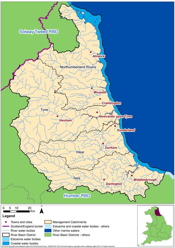
and Saltholme bird reserves. The Northumbria RBD is made up of 4 management
catchments (see map in Figure 1 below).
The FRMP describes the scale of flood risk in the Northumbria RBD which includes:
26,150 people are at risk from the 1% annual probability event of fluvial flooding and
many more at risk from the sea along the east coast.
Many towns such as Newcastle, Hexham and Morpeth benefit from flood defences,
but flood risk remains a significant within the RBD.
The Northumbria RBD has significant areas of rural land use and forestry planting,
which slows down the speed at which water reaches rivers, however many of the
catchments, such as the Wansbeck are steep and rocky, and as such respond
rapidly to rainfall events.
Key infrastructure includes Kielder reservoir, which covers 11km2 and supplies water
to the majority of the RBD, and the strategic infrastructure at Teesmouth (serviced bythe A19), which includes refineries and chemical works that play a significant role in
the UK economy..
In general, groundwater is not a significant source of flooding in the Northumbria
RBD.
Figure 1: Northumbria RBD catchmentsThe Northumbria RBD FRMP sets out the objectives and measures to manage flood risk,
from the Environment Agency and the Lead Local Flood Authorities for the Northumbria
RBD.
Measures within the FRMPs have been developed by the Environment Agency and the Lead
Local Flood Authorities (LLFAs) within the respective FRMP areas, i.e. the RBDs.
Measures within the FRMPs are either already developed, these are derived from existing
plans, which have been separately consulted on and published with accompanying
assessment, including Habitats Regulations Assessment (HRA); or are new measures,
developed specifically for inclusion in the FRMP. The source of the measures has
determined how they have been treated in the HRA.
Existing plan measures in the Northumbria draft FRMP are derived from the following source
plans:
Catchment Flood Management Plans (CFMPs)
Local Flood Risk Management Strategies (FRMS) developed by LLFAs.
The measures derived from these plans have already been subject to consultation and
assessment, including HRA. Where measures taken from existing plans have been deemed
to potentially affect European sites, the HRAs of those source plans have been referred to.
1.4 Background to Habitats Regulations Assessment
In England, the Conservation of Habitats and Species Regulations 2010, as amended,
commonly termed the Habitats Regulations, implements the European Union Habitats
Directive (Directive (92/43/EEC) on the Conservation of natural habitats and of wild flora and
fauna, and certain elements of the Wild Birds Directive (2009/147/EC). This legislation
provides the legal framework for the protection of habitats and species of European
importance in England.
Sites protected under the Habitats Regulations comprise Special Protection Areas (SPA),
Special Areas of Conservation (SAC), candidate SACs (cSAC), Sites of Community
Importance (SCI) and, as a matter of government policy, to potential Special Protection
Areas (pSPA) and Ramsar sites (sites designated under the 1971 Ramsar Convention for
their internationally important wetlands). These sites are referred to collectively as in this
report as ‘European sites’.
Regulation 9(3) of the Habitats Regulations requires that a ‘competent authority’ must
consider the requirements of Habitats Directive in exercising any of its functions. Article 6(3)
of the Habitats Directive defines the requirements for assessment of plans and projects
potentially affecting European sites. This requires that a competent authority, before
deciding to undertake, or give any consent or authorisation for a plan or project which is
likely to have a significant effect on a European site, and is not directly connected with or
necessary to the management of that site, must carry out an appropriate assessment. The
term commonly referred to for the assessment process is ‘Habitats Regulations
Assessment’.The Northumbria FRMP is considered to fit within the definitions of a ‘plan’ as defined by the Habitats Directive, and requires a Habitats Regulations Assessment (HRA). The FRMP is a high-level planning document for the Northumbria River Basin District (RBD) (see map in Figure 1), therefore potential impacts of the plan on European sites across the RBD are difficult to determine. Given the geographic scale and nature of the plan, the HRA has been tailored to be appropriate for the spatial area of coverage and the strategic nature of the plan. The Habitats Regulations Assessment has followed a framework of four distinct stages, only moving to the next stage if required by the results of that stage of the assessment. The four stages are: Stage 1: Screening and Likely Significant Effects is the process which initially identifies the likely impacts upon a European Site of a plan or project, either alone or in combination with other plans or projects, and considers whether these impacts may be significant. This stage also includes the development of mitigation to avoid or reduce any possible effects. Stage 2: Appropriate Assessment is the detailed consideration of the impact on the integrity of the European Site of the plan or project, either alone or in combination with other plans or projects, with respect to the site’s conservation objectives and its structure and function. This is to determine whether there is objective evidence that adverse effects on the integrity of the site can be excluded. This stage also includes the development of mitigation to avoid or reduce any possible effects. Stage 3: Assessment of alternative solutions is the process which examines alternative ways of achieving the objectives of the plan or project that would avoid adverse impacts on the integrity of the European Site, should avoidance or mitigation be unable to avoid adverse effects. Stage 4: Assessment where no alternative solutions exist and where adverse effects remain is made with regard to whether or not the plan or project is necessary for imperative reasons of overriding public interest (IROPI) and, if so, of any required compensatory measures.
2 European sites in the Northumbria RBD
Within the Northumbria RBD there are 25 SACs, 13 SPAs, and 8 Ramsar sites.

Figure 2 - Map of the European sites in the Northumbria River Basin District

Some of the sites have more than one designation such as the Northumbria Coast, parts of
which are designated as SPA and SAC. Although most of the European sites contain a
variety of habitat types, broadly speaking they could be described as coastal and marine
sites, freshwater sites (comprising rivers, lakes, canals and other wetlands) and terrestrial
sites such as woodlands, grasslands and moorlands. Of the 2 Ramsar sites, Lindisfarne is a
coastal site and Holburn lake and Moss is freshwater. Most SPAs in the RBD are wetland
habitats and are coastal, with the exception of Holburn Lakes and Moss, which is freshwater,
and the North Pennine Moors, which is upland. The 25 SACs in the Northumbria RBD range
in size and nature from the relatively small Thristlington SAC, designated for its calcareous
grassland (22 hectares (ha)), to the Northumbria Coast (65000ha), which is designated for a
number of qualifying habitats including vegetated sea cliffs and reefs.

Annex B contains a summary of the European sites present within Northumbria RBD. Table
A2 in Annex A presents a summary of the European sites present within the management
catchments of the Northumbria RBD. In a number of cases European sites cross over the
boundary of two or more management catchments, therefore a number of European site
names / designations may appear against more than one management catchment.

2.1    European sites that could be affected by the FRMP
The Northumbria FRMP is a long term plan for the water environment, which could
potentially affect both water dependent and non-water dependent European sites and their
qualifying features.

Water dependent European sites are classified as protected areas under the WFD; each
protected area European site has specific objectives to ensure their favourable conservation
status. Supporting measures within the Northumbria River Basin Management Plan (RBMP)
should predominantly be beneficial for the conservation status of water dependent European
sites, and the Northumbria FRMP seeks to align with the objectives of the Northumbria
RBMP wherever possible. Where feasible, measures to improve water body status from the
Northumbria RBMP are identified against the FRMP measures.

It is not possible from the outset to rule out, at the RBD scale, any (water-dependent or non
water-dependent) European sites from being affected by the Northumbria FRMP. The HRA
(in particular Section 4.2) reviews the European sites by management catchment, and
determines whether any of the measures within the catchments are likely to lead to
significant effects on European sites.

2.2    European sites and their status for FRMPs
The Northumbria RBMP provides summary information on the current status and baseline
for water-dependent European sites as part of its monitoring data.

European sites in England, with the occasional exception, are also designated as SSSIs.
Natural England monitors the conditions of SSSIs and their component units using six
reportable condition categories: favourable; unfavourable recovering; unfavourable no
change; unfavourable declining; part destroyed and destroyed.

The current status of water-dependent European site protected areas for the Northumbria
RBD is summarised in table 1 below. This gives the current area of water-dependent SSSI
units of European protected areas in different condition categories as currently recorded on
Natural England’s designated site data system. SSSI units underpin European protected
areas and Natural England only collects data at a SSSI unit level. When SSSI units are in
favourable condition, they are deemed to be meeting their conservation objectives.
Table 1 WFD status of water dependent SSSIs for the Northumbria RBD (Extract from
Natural England databases August 2015)

                                     Northumbria RBD
    Condition                              (ha)
    Favourable                             26,782
    Destroyed / Part destroyed                0
    Unfavourable declining                   484
    Unfavourable no change                   296
    Unfavourable recovering                34,334

    Total Area Unfavourable                35,114

    % Unfavourable                            57

This shows that for the Northumbria RBD, 57% of water-dependent SSSI units of European
protected area sites are currently not compliant with the condition requirements.

The generic pressures on such sites in the Northumbria region include freshwater point
source and diffuse pollution, siltation, forestry and woodland management, agricultural
practices and diffuse pollution, under or over grazing, drainage, invasive non-native species,
and public access and disturbance.

There are also long term national threats to habitats and especially species, including
climate change, alterations in hydrological and coastal processes and invasive non-native
species.

2.3       European sites and their management
As part of a new strategic approach to managing all England’s European sites, new
measures needed to achieve favourable conservation status for all European sites in
England have been developed by Natural England. These are collectively referred to as Site
Improvement Plans (SIPs), and are being developed by the Improvement Programme for
England’s Natura 2000 sites (IPENS). SIPs were published for all European sites in
England in 20152.

The Northumbria FRMP recognises SIPs include actions where flood risk management is
specifically a mechanism for their delivery. Information on SIPs within the RBD that may
include actions allocated to flood risk management can be found using the footnote link.

2
 Site Improvement Plans for the Northumbria River Basin District can be found on:
http://publications.naturalengland.org.uk/category/6287197783195648
3 Approach to the HRA
The steps undertaken to complete the HRA are as follows:
describe the plan and the measures proposed
screen and assess the likely significance of any effects on European sites
consider need for further stages of assessment (i.e. appropriate assessment,
alternative solutions and IROPI)
determine a plan level conclusion.
3.1 Description of the FRMP programmes of measures
The Northumbria RBD FRMP is a joint publication of several plans required under the Flood
Risk Regulations that are the separate responsibilities of specific Risk Management
Authorities (RMAs), as follows:
Northumbria River Basin District catchments (Environment Agency)
North Yorkshire Council LLFA
3.1.1 River Basin District Catchments
FRMPs for the River Basin District (RBD) are being published by the Environment Agency
(for English catchments) and Natural Resources Wales (NRW) (for Welsh catchments), and
are focused on measures principally to address flood sources from main river, the sea and
reservoirs. The measures have been divided into catchments based on the River Basin
Management Plans (where they are called ‘management catchments’).
Production of the FRMPs for the RBDs is the legal duty of the Environment Agency and
NRW. Where any voluntary information on local sources of flooding within RBD catchments
has been provided by LLFAs, these are published by joint agreement in the RBD FRMP.
The Environment Agency and NRW are also the competent authority under the Habitats
Regulations for the RBD FRMPs.
3.1.2 Applying HRA
In applying the HRA process, each RBD catchment was assessed and a final summary of
conclusions and recommendations for future HRAs is provided that also draws on a high-
level summary of the potential for in-combination effects of the FRMP with other key plans.
3.2 Screening and Likely Significant Effects
This first stage of the HRA process requires consideration of screening and likely significant
effects of measures on European sites. The tasks undertaken to complete this are as
follows, and set out in more detail below:
screening out catchments where no European sites are present
screening out measures that would not have physical effects
considering measures from existing plans, with mitigation / controls already agreed in
HRAs for any likely significant effects, or in some cases potential adverse effect on
site integrity considering new measures and their likely significant effects, with mitigation / controls
where considered necessary
conclusion from screening and likely significant effects.
The results of these tasks for each RMA’s plan of the FRMP are provided in chapter 4.
3.3 Screening out catchments where no European sites are present
Where there are no European sites present in a catchment, it was determined that no further
consideration of measures in the catchment is required. Given the level of detail in the plan
where the FRMP measures are mainly strategic in nature and are not specific on their
precise location, there is insufficient details to consider downstream or down drift effects
beyond the catchment. However, such screening for cross-catchment effects will be a
requirement in assessing local plans and projects.
3.4 Screening out measures that would not have physical effects
Every measure included within the FRMP is categorised according to one of the following 4
categories, accompanied by an M-code:
Prevention (M2) - reducing the impacts of flooding through land use and
development policy, relocation of assets at risk, or measures to divert the hazard to
avoid harm.
Protection (M3) - protecting people from the risk of flooding; for example, by the
maintenance, refurbishment of existing defences or building new defences.
Preparedness (M4) - by taking actions that prepare people for flooding; for example,
by improving awareness of flood risk, or by providing warning and forecasting for
floods.
Recovery and review (M5) - supporting recovery after flooding has happened and
reviewing how things can be improved; for example, by improving the availability of
recovery services such as providing temporary accommodation.
Other (M6) – measures not fitting in to any of the above categories.
Further definitions of each of the measures are set out in the FRMP according to a second
tier of M-codes. For example, Prevention (M2) includes the second tier measure, M22, which
is defined as “Prevention, removal or relocation measure to remove receptors from flood
prone areas or to relocate receptors to areas of lower risk”. These measure definitions have
been used as the basis for the initial screening out of the measures that require no for further
consideration within the HRA.
The measure codes and their definitions are included as Table A1 (in Annex A to this
document). Measures under ‘Preparedness’ (M4) and ‘Recovery and review’ (M5) will not
result in development, demolition or changes of management ‘on the ground’ that could
result in effects on European sites. These were therefore screened out from any further
consideration. Similarly, under the ‘Prevention’ category (M2), only the removal or relocation
of receptors from flood prone areas could potentially affect European sites. The measures
that have been screened in to the assessment are set out below and have been highlighted
in Table A1: M22 – Prevention – removal or relocation (category)
M3 – Protection – all sub-categories
M6 – Other – not yet defined.
3.5 Considering measures from existing plans
Risk Management Authorities have a range of plans in place for developing and
implementing measures related to flooding from main river (in Catchment Flood
Management Plans), to flooding from the sea (in Shoreline Management Plans) and related
to local sources of flooding (e.g. in Local Flood Risk Management Strategies). These plans
have been subject to HRA where relevant, and have reported on the effects on European
sites consistent with the level of detail of the plans.
For this HRA, these existing HRAs have been used to summarise the effects of measures
from existing plans that are now set out under specific RBD catchments or FRAs. For many
RBD catchments and FRAs there are multiple existing plans covering the geographic area
but also some existing plans that are split across RBD catchments or FRAs. Nonetheless we
have separated out the ‘screened in’ measures from individual existing plans and referenced
the specific HRA results that apply to them.
The results from existing HRAs have considered the extent that they remain valid since they
were published. This has been done by checking the status of the relevant European sites
that were considered within the source plan’s HRA for any changes to site designations
since the date of the HRA publication. The criteria were agreed with Natural England and
comprised: whether there were any new / additional site designations, any changes in site
boundaries, changes in designated site features, or any significant changes in site
conditions.
One of the main reasons for a likely change from when the effects of plan measures were
reported in HRAs is where there have been boundary changes to European sites or to the
scope of condition of the interest features of the sites i.e. specific habitats, species etc.
Where we have been advised that such changes have occurred and are significant then this
has triggered further consideration of the validity of the existing HRA results that we have
relied upon.
3.6 Considering new measures for FRMP cycle 1
In reviewing the range of measures across existing plans covering all sources of flooding,
Risk Management Authorities (RMAs) have taken the opportunity to put forward further
strategic developments for the next 6 year cycle of the FRMP. These ‘new measures’ focus
on: strengthening the joint working of RMAs across all flood sources; developing more
integrated management of the water environment as set out in the River Basin Management
Plans and other related plans; and updating flood risk information to help manage risks with
communities.
For this HRA we have reviewed the set of new measures that have been ‘screened in’ for
each catchment. As they are mostly ‘strategic’ measures without specific information on
location or the form of action that would be developed on the ground, we have considered a
range of factors that would give rise to any likely risks from this set of measures in a specific
catchment, which includes: their general proximity in the catchment to European sites
whether they aim to address sources of flooding that are local, or main river or
related to the coast
the mix of types of new measures within the catchment denoted by their M-codes
(i.e. whether they are mainly maintenance, or channel works, or new solutions).
General proximity was considered by narrowing down the set of measures within a
catchment to those that were closer in general and more likely to be connected to European
sites by the hydrology of the catchment rather than applying specific buffer distances to
individual measures.
3.7 Considering the need for further stages of assessment
HRA steps were carried out for each RBD catchment of the RBD plan that is the
responsibility of the Environment Agency. Further HRA steps were carried out for each FRA
(by catchment) that is the responsibility of respective Lead Local Flood Authorities. The
determination for each catchment or FRA that there are no likely significant effects to
European sites, is based on the following assumptions:
that this HRA does not remove the need for HRA at a subsequent level, i.e. lower tier
strategies, plans or projects that implement measures, nor does it give any weight to
their outcomes. Consideration of potential impacts and options available to mitigate
for those impacts should assist, but not influence or constrain any lower-tier
assessments.
that as local actions are developed at a project level and the details of their scope
and scale are known, that this may identify additional effects on European sites that
have not been assessed here, or were not appropriate to consider at this spatial
scale of plan.4 Northumbria River Basin District Catchments HRA This chapter sets out the results of carrying out the HRA on the measures for the Northumbria RBD catchments that are for flooding from main river, sea and reservoirs and for local flooding sources outside of Flood Risk Areas. This is the FRMP information for which the Environment Agency is the FRMP ‘statutory authority’ and HRA ‘competent authority’. This section covers the following stages of the assessment: Summary of measures being assessed Screening and assessment of likely significant effects Consideration of results and conclusion 4.1 Summary of Measures The initial screening and assessment of likely significant effects reviewed the measures for each of the 4 management catchments within the Northumbria draft FRMP. Figure 3 - Map of the Northumbria river basin district and management catchments A summary of the measures and their screening is given below for each catchment.
Table 2: Summary of measures by catchment
Management Number of measures Number of new measures and
measures screened
Number of measures
Number of European
from existing plans1
Catchment related to types of known level of detail1
measures for cycle
existing plans1
Number of
Number of new
in (out)
one1
sites
Catchments with no screened in measures
All catchments have some screened in measures
Catchments with all measures from existing plans
Northumberland 16
16 16 from CFMPs 0 No new measures 14
Rivers (6)
10
Tyne 10 10 from CFMPs 0 13
(17)
16
Wear 16 16 from CFMPs 0 10
(8)
Sub-total 42 42 42 from CFMPs 0
(31)
% all measures (n/a)
37% 37%
Catchments with new measures for cycle 1 of the FRMP
Northumbria 2 0 2 0 not in proximity n/a
RBD Wide (0) 2 strategic/proximity
unknown
0 specific/in proximity
Tees 10 4 4 from CFMPs 6 5 not in proximity 9
(30) 0 strategic/proximity
unknown
1 specific/in proximity
Sub-total 12 4 4 from CFMPs 8 5 not in proximity
(30) 2strategic/proximity
unknown
1 specific/in proximity
% all 10% 3% 7%
measures2
Overall Total 46 46 from CFMPs 8 5 not in proximity
54 2 strategic/proximity
(61) unknown
1 specific/in proximity
2
% all measures 47% 40% 40% from CFMPs 7% 4% not in proximity
2% strategic/proximity
unknown
1% specific/in proximity
1
all numbers are of 'screened in' measures, except those in brackets
2
all %s are of total of all 'screened in and out' measures
'in proximity' means being generally in the same part of the catchment (specific distances are not applied, but further detail is provided
in the assessment)
'specific' is where a measure is place specific, 'strategic' is where a measure is catchment or RBD-wide
3
Measures across several catchments are counted up for each catchment for HRA purposes which may be a higher figure than
reported in the FRMP.
Of the total of 115 measures 47% have been screened in for HRA consideration (53%
screened out). All management catchments within the Northumbria RBD have some
screened in measures and are considered further.
There are 2 measures that are RBD-wide and are considered in section 4.2.4.2.There are a number of measures from the neighbouring Humber river basin districts that
were included in Northumbria RBD catchments and are considered in section 4.2.4.3
4.1.1 Risks from existing plan measures
40% of all FRMP measures (excluding Flood Risk Areas) are screened in and from existing
plans that are CFMPs. Most risks are from land management measures where adverse
effects were identified in the CFMP HRA for all of the management catchments.
4.1.2 Risks from new measures
7% of all FRMP measures (excluding Flood Risk Areas) are screened in and new measures,
4% are not in proximity to any European sites, 1% are strategic without locations, and 1%
are more specific measures to restore peat bog formation that are in proximity to the upland
sites; Moorhouse Upper Teesdale and the North York and North Pennine Moors.
4.2 Screening and Likely Significant Effects
The management catchments that make up the Northumbria RBD FRMP are set out in table
3 below. The colour coding in the table summarises the nature and source of the bundle of
measures, which forms the basis for how each management catchment has been assessed.
The following sub-sections consider each of the management catchments in turn.
Table 3 Management Catchments of the Northumbria RBD /FRMP
Management Catchment Category Management Catchments
Management catchments with no None
European sites present.
Management catchments with no None
‘screened in’ measures.
Management catchments with all Northumberland Rivers
measures from existing plans. Tyne
Wear
Management catchments with new Tees
measures.
4.2.1 Management catchments with no European sites present
All management catchments within the Northumbria RBD have European sites present,
therefore no management catchments have been ruled out of further consideration on this
basis.
4.2.2 Management Catchments with no ‘screened in’ measures
All management catchments within the Northumbria RBD have screened in measures,
therefore no management catchments have been ruled out of further consideration on this
basis.
4.2.3 Management Catchments with all measures from existing plans
The following management catchments in the Northumbria FRMP do not contain any FRMP
new measures; they contain only measures from existing plans.Each of these plans has already been subject to consultation and assessment, including
HRA. The HRA conclusions for those source plans have been referred to in each case.
4.2.3.1 Northumberland Rivers Management Catchment
European New measures Existing plan measures
sites
Screened in Screened out Screened in Screened out
14
0 0 16 6
The Northumberland Rivers management catchment contains 14 European sites. Many of
these sites are designated for coastal habitats and species, such as the Northumbria coast,
Lindisfarne, Coquet Island and the Farne Islands. There are 4 European sites which are not
located on the coast, these are in upland areas. There are no proposed measures within
this catchment; all of the 50 measures are from existing plans.
Wansbeck and Blyth and North East Northumberland CFMPs
Half of the measures are from the Wansbeck and Blyth CFMP. The majority of the CFMP
measures are protection measures (M3) and are considered further below; the screened out
CFMP measures relate to emergency flood event response / contingency planning (M44).
The Wansbeck and Blyth CFMP boundary sits within the Northumberland Rivers
management catchment, and this catchment also encompasses the North East
Northumberland CFMP (see below). The 16 CFMP protection measures incorporated within
the Northumberland Rivers management catchment implement the policies of the CFMP,
which were assessed by the Wansbeck and Blyth and the North East Northumberland
CFMP HRA’s. The CFMP HRA assessed potential effects on European sites and concluded
that the policies and actions within the Wansbeck and Blyth and the North East
Northumberland CFMP’s had the potential to have a significant impact on European sites as
a result of habitat damage and loss, disturbance to species and changes in flooding regimes
causing damage to habitats such as dry heath land. An appropriate assessment was carried
out which identified mitigation for impacts such as timing of works, further investigation work
to ensure changes made would not impact on key habitats, and limiting vegetation
clearance. Following implementation it was concluded that the Wansbeck and Blyth and
North east Northumberland CFMP’s were not likely to have an adverse impact on site
integrity.
4.2.3.2 Tyne Management Catchment
European New measures Existing plan measures
sites
Screened in Screened out Screened in Screened out
13
0 0 10 17
The Tyne management catchment contains 13 European sites. The North Pennine Moors
and Northumbria Coast flank the western and eastern sides of the management catchment
respectively. The remaining sites tend to lie to the west of the management catchment in
the uplands, with the Tyne and Nent and Tyne and Allen river gravels being the only 2
riverine sites. There are no new measures within this catchment; there are 27 measures
from existing plans of which 17 are screened out as they relate to flood preparedness (M4).Tyne CFMP
All of the measures screened in fall under M2 (protection) and M3 (prevention) codes. The
Tyne CFMP boundary follows the Tyne management catchment boundary of the FRMP.
The CFMP HRA concluded that there was potential for significant effects such as habitat
loss / physical damage, changes in flood inundation / frequency, changes in physical regime,
changes to water quality, disturbance and habitat / community simplification. Mitigation
proposed included design of schemes in partnership to ensure no adverse impacts on
European sites, timing and location of works. As the measures were not geographically
fixed, there is sufficient flexibility to ensure no adverse effects on integrity occur. With
mitigation applied the conclusion of the appropriate assessment was that there would be no
adverse impact on site integrity.
4.2.3.3 Wear Management Catchment
European New measures Existing plan measures
sites
Screened in Screened out Screened in Screened out
10
0 0 16 8
The Wear management catchment contains 10 European sites. The larger of these sites lie
along the coast (Teesmouth and Cleveland Coast, Northumberland Coast and Durham
Coast) and to the south and west of the management catchment (North Pennine Moors).
There are no new measures within this catchment; all of the 24 measures are from existing
plans. Of the 16 measures screened in, 10 are M3 (Protection) codes, and 6 are M2
(prevention). The majority of the measures screened in are related to catchment based
interventions such as woodland creation and withdrawal of maintenance from agricultural
areas.
Wear CFMP
The Wear CFMP stage 1 assessment identifies impacts to European sites as a result of
habitat creation measures, withdrawal from banks and grip blocking. The impacts of these
measures were identified as changes to hydrological regimes, habitat disturbance, species
disturbance and habitat simplification. Mitigation identified was to ensure schemes are
designed in partnership and to avoid adverse impacts, and location and timing of works to
avoid impacts. As the measures are not geographically fixed, there is sufficient flexibility to
ensure no adverse effects on integrity occur. With mitigation applied the conclusion of the
stage 2 appropriate assessment was no adverse impact on site integrity.
4.2.4 Management Catchments with New Measures
4.2.4.1 Tees Management Catchment
European New measures Existing plan measures
sites
Screened in Screened out Screened in Screened out
9
6 1 4 29The Tees management catchment contains 9 European sites. In total there are 10 screened in measures for the Tees management catchment, of which 6 are EA proposed as part of the FRMP. The Tees Management Catchment contains nine European sites, comprising Moor House - Upper Teesdale SAC, North Pennine Dales Meadows SAC, North Pennine Moors SAC and SPA, North York Moors SAC and SPA, Thrislington SAC, Teesmouth & Cleveland Coast SPA and Ramsar, Of these, the North Pennine Moors, the North York Moors, and the Teesmouth and Cleveland Coast are the largest areas of European sites. The Teesmouth and Cleveland coast flanks the eastern area of the management catchment and is adjacent to the densely populated areas of Hartlepool and Middlesbrough. Tees CFMP There are 33 measures from the Tees CFMP in the Humber FRMP, 4 of which are screened into this assessment. The Tees CFMP concluded that there was potential for measures to significantly impact on European sites as a result of habitat loss / physical damage, changes in flood inundation / frequency, changes in physical regime and disturbance. A subsequent appropriate assessment looked further at these impacts, and concluded that with mitigation such as the management of timing and location of works, and designing out of impacts the impacts are not expected to have an adverse impact on site integrity. New measures There are 7 FRMP measures proposed by the Environment Agency. The Environment Agency measures are protection measures (M3) and one is prevention (M23). Six measures are screened in for further consideration. One measure which relates to investigations into peat restoration has been screened out. Of the 6 EA proposed measures, one is to look at improved protection for Port Clarence and Greatham South. This scheme has been appraised and has already been subject to a project level Habitats Regulations Assessment which concluded that there would be no adverse effect on site integrity. Of the remaining actions, 5 of them are between 2 and 20km away from any designated sites. Given this distance and the likely scope of work, impacts are considered unlikely. Given the general scope and the strategic scale of the measures, the FRMP does not specify or constrain how or where measures are implemented. The measures will be subject to project level control through the relevant consenting process and the associated requirement for the consideration of project level HRA. At this strategic plan level, a range of mitigation options have been identified (see section 4.3.3 and also Table A3 in Annex A). In light of the mitigation options available to adequately avoid or mitigate for impacts, the measures are screened as not likely to lead to significant effect on European sites. This is a plan-level conclusion and does not remove the need for lower-tier HRA, nor does it influence the conclusions or specific need for appropriate assessment to investigate mitigation options in more detail. 4.2.4.2 RBMP Wide Measures There are 2 measures which are proposed in all management catchments. These are to ensure climate change adaptation is incorporated into flood risk management projects, and
to consider natural flood management as a mechanism to adapt to and increase resilience to
climate change impacts. The FRMP does not constrain how or where these measures are
implemented, and both measures will be subject to subsequent appraisal and assessment at
the project level if required. At this strategic plan level, a range of mitigation options have
been identified (see section 4.3.3 and also Table A3 in Annex A). In light of the mitigation
options available to adequately avoid or mitigate for impacts, the measures are screened as
not likely to lead to significant effect on European sites. This is a plan-level conclusion
and does not remove the need for lower-tier HRA, nor does it influence the conclusions or
specific need for appropriate assessment to investigate mitigation options in more detail.

4.2.4.3         Cross boundary measures
 European         New measures                       Existing plan measures
 sites
                  Screened in      Screened out      Screened in         Screened out
          9
                        2               14                  0                   0

There are 16 cross boundary measures from the Humber FRMP that occur in Northumbria
catchments. These measures sit within the Tees management catchment. 14 of the
measures have been screened out as they relate to modelling work (M2), policy updates
(M5) and communications (M4). The 2 measures that have been screened in both relate to
M3 codes and are to work to maintain and deliver a prioritised programme of work within the
management catchment. As these measures are not geographically fixed, or fixed in terms
of scope, project level mitigation can be applied to ensure impacts are avoided during the
development of project level HRA, if required. With this mitigation in place it is concluded
that these 2 measures are not likely to lead to significant effect on the European sites.

4.3     Consideration of results and conclusion
The assessment of likely significant effects has been carried out for each catchment in turn.
The risks to European sites for those measures drawn from existing plans have been
considered with reference to existing HRAs and existing controls in place. The potential
risks arising from new strategic priorities for the next FRMP cycle have also been
considered.

In all catchments the conclusions are that likely significant effects can be avoided or
mitigated by appropriate controls and actions that are currently in place or will be in place at
a project level, when local actions are developed to implement the plan.

4.3.1         Risks from existing plan measures
30% of measures are from existing plans, of which 100% are from CFMPs. Most risks are
from land management measures where adverse effects were identified in the CFMP HRA
for all of the management catchments.

All risk management authorities responsible for implementing the measures in the FRMP
that are sourced from the existing CFMPs and SMPs, where risks to Europeans sites have
been identified, are required to take account of the HRAs of those plans (as identified in
section 4.2 above) and any mitigation proposals or statements made within them.
4.3.2 Risks from new measures 18% of measures are new, of which 80% are not in proximity to any European sites, 10% are strategic and not defined in scope or location, and 10% are more specific measures to restore peat bog formation that are in proximity to the upland sites; Moorhouse Upper Teesdale and the North York and North Pennine Moors. 4.3.3 Control and Mitigation for main risks from new cycle 1 measures Controls The principal controls for the development of local actions from new FRMP measures that are more specific and are in the proximity of European sites comprise the consenting procedures in place to assess proposed actions in order to authorise implementation. Actions involving construction or creation of new, or changes to, alteration or improvement of existing flood defence structures affecting main river are likely to require planning permission. In some cases, flood risk management may ordinarily be permitted development. Other types of actions may require controls under Flood Defence Consents from the Environment Agency for main rivers or Lead Local Flood Authority (LLFA) for non- main watercourses. Where a European site is potentially affected, the need for project level HRA is determined through the planning process, the required information is submitted with the planning application, with the assessment being the responsibility of the local planning authority as competent authority. A determination is made in consultation with Natural England. Even where the action would normally be permitted development, approval of the local planning authority is required where a development is likely to have a significant effect on a European site. As part of these consenting mechanisms, the measures cannot receive approval to proceed until it has been demonstrated that they will not result in adverse effects on integrity of any affected European sites. Or, where an adverse effect cannot be avoided, a case for ‘Imperative Reasons of Overriding Public Interest’ (IROPI) that includes the identification of compensatory measures is approved by the Secretary of State for Environment, Food and Rural Affairs. Table A3 in Annex A provides additional detail on the consenting processes and the consideration of the Habitats Regulations as they relate to measures to address flooding from the various flooding sources (e.g. main river, ordinary watercourses, tidal, reservoir). Mitigation Implementation of measures at the subsequent tier of plan or project, if deemed likely to result in significant effect on one or more European sites, may need to include mitigation to avoid or reduce potential effects. Specification of mitigation should be tailored to the specifics of a project, and to the sites and features potentially affected, through the project level HRA process and through consultation with Natural England, ideally early in a project’s appraisal and design. That way, mitigation can be incorporated into the way that the project is designed and built, tailored to the specifics of the site/s and their qualifying features, and therefore be most effective in avoiding or reducing potential adverse effects. Project-level mitigation for European site species would consider the potential impacts arising from construction and operation of the project / measure, alongside any site specific
sensitivities of the affected species. Depending on the nature of the project, identification of
the use of habitats in proximity by qualifying species and the functioning role of those
supporting habitats affected, may either be established by existing data / studies or may
need to be established through site survey.
Construction-related mitigation should consider managing the timing of activities to avoid
ecologically sensitive periods, such as breeding, over-wintering or migratory passage
periods for birds, or migratory periods for anadromous fish. The exact timings for these
construction ‘windows’ may vary for different sites in the RBD, depending on the presence,
distribution and proximity of qualifying species present. Avoidance or reduction of visual or
noise disturbance to species may also consider the use of techniques such as screening,
segregation or establishing buffer zones, recognising that some species may be more
vulnerable or sensitive than others (for example different bird species can vary in their flight
response). For potential construction impacts on habitats, such as loss of habitat or physical
damage, key construction-focused mitigation should focus on the avoidance of working on,
or in proximity to sensitive habitats, and development of site sensitive construction
techniques. This may for example include avoiding heavy plant usage in particular areas, or
screening / creation of buffer zones to avoid any disturbance or physical damage. This can
be informed through site specific / project-level HRA, and supporting survey where
necessary, to establish the presence, nature and sensitivities of potentially affected habitats.
For potential operational effects, sensitive and sympathetic design can minimise or avoid
effects, such as appropriate location or layout of any structures (set-back from sensitive
habitats) or minimising footprints where possible. Project-level HRA should also consider
potential changes in physical processes, such as changes to flows / velocities and the
physical regime, and potential water quality changes, for example due to the addition or
removal of a structure or a changed profile of the riparian zone / channel banks. Such
effects, as identified through the HRA, should inform a project’s appraisal and the building of
suitable mitigation into the design.

4.3.4      Conclusion
The assessment above has considered the FRMP information in RBD catchments that the
Environment Agency are responsible for and has screened the measures as having no likely
significant effect. This is concluded in light of the range of avoidance and mitigation
measures available.
Regulatory controls will identify any risks to European sites when the actions required to
implement the measures are developed. The FRMP itself also makes it clear that before any
measures in the plan are implemented they must be subject to the requirements of the
Habitats Regulations by the relevant competent authority. This is already the case for
measures from existing plans where HRAs have identified risks to European sites and where
any adverse effects that cannot be ruled out have been addressed through appropriate
mitigation and compensatory provision.
It is concluded that at this strategic-plan level, the measures are screened as being not likely
to have any significant effects on any European sites, alone or in combination with other
plans or projects (see chapter 7). Given this conclusion, there is no requirement to progress
to the next stage of the Habitats Regulations Assessment (an ‘appropriate assessment’ to
examine the question of adverse effect on the integrity of European sites). Lower-tier
assessments will be required and will be assisted by the information gathered in this high-
You can also read