Newtownpark Avenue SHD, Blackrock, County Dublin - Newtownpark Avenue ...
←
→
Page content transcription
If your browser does not render page correctly, please read the page content below
Newtownpark Avenue SHD,
 Blackrock, County Dublin
Desktop archaeological assessment

                Prepared by
        John Cronin & Associates
         3a Westpoint Trade Centre
                Ballincollig
                   Cork

              Commissioned by
          Glenveagh Homes Ltd
         c/o John Spain & Associates
             39 Fitzwilliam Place
                   Dublin 2

              October 2020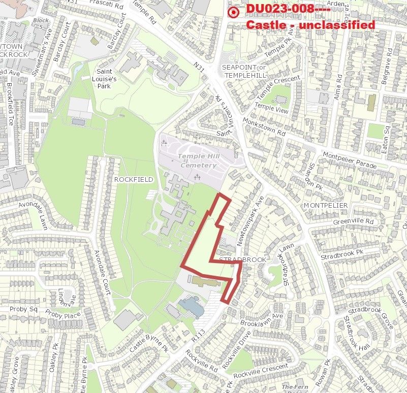
Document Control Sheet
Client                                 Glenveagh Homes Ltd
Project Title                          Newtownpark Avenue SHD, Blackrock, County Dublin
Document Title                         Desktop Archaeological Assessment
Document No.
Document Comprises                         DCS        NTS        TOC     Pages                          20
                                           Yes        No         Yes     Appendices                     1

  Rev       Status          Author(s)          Reviewed By         Approved By           Office of       Issue Date
                                                                                          Origin
   01       Draft         Paudie Dunne        David Murphy          John Cronin            Cork          06/04/20
   02      Revision       Paudie Dunne        David Murphy          John Cronin            Cork          25/09/20
   03       Final         Paudie Dunne         John Cronin          John Cronin            Cork          21/10/20

© 2020 Cultural Resource Management and Planning. Ltd. ‘John Cronin & Associates; is a trading name of
Cultural Resource Management and Planning. Ltd. All Rights Reserved. Cultural Resource Management & Planning
Ltd has used reasonable skill, care and diligence in compiling this report and no warranty is provided as to the report's
accuracy. Cultural Resource Management & Planning Ltd is not responsible for any errors or omissions, or for the
results obtained from the use of information outlined in this report. No part of this report may be copied or reproduced,
by any means, without the written permission of Cultural Resource Management & Planning Ltd.

                                                             Newtownpark Avenue SHD, Blackrock, County Dublin
                                                                           Desktop Archaeological Assessment                i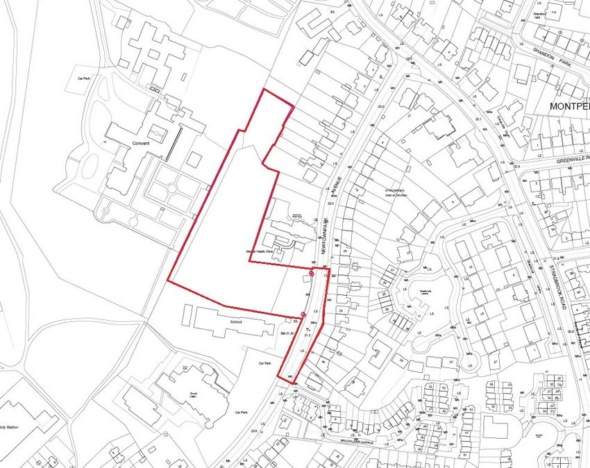
Contents
1.    Introduction ..................................................................................................................................................... 1

2.    Methodology ..................................................................................................................................................... 2

3.    Context ................................................................................................................................................................ 4

4.    Description of site ....................................................................................................................................... 11

5.    Conclusions and recommendations ..................................................................................................... 13

6.    References/sources .................................................................................................................................... 14

Appendix: Relevant Excavations.ie entries ................................................................................................ 15

                                                                                        Newtownpark Avenue SHD, Blackrock, County Dublin
                                                                                                      Desktop Archaeological Assessment                                            ii
1. Introduction
John Cronin & Associates have been commissioned by Glenveagh Homes Ltd to assess the
archaeological potential of the site of a proposed residential development at Rockfield, Blackrock,
in south County Dublin (Figure 1). The site is located to the west of Newtownpark Avenue and
consists of a greenfield area which was previously part of HSE complex of Cluain Mhuire. The
subject site was subject to a previous planning application in 2015 (Dún Laoghaire-Rathdown Co.
Co. Ref: D15A/0036).
The development will consist of the demolition of the existing c. 26sqm single storey shed on site
and construction of a residential development comprising 140 no. residential apartments and
duplex units across 5 no. 2 to 5 storey buildings (with a basement under Blocks C + D), an
ancillary single storey concierge/reception building, 97 no. carparking spaces, 226 no. cycle
spaces, a single storey ESB substation, hard and soft landscaped areas, public lighting,
attenuation, service connections, bin stores, a new pedestrian crossing on Newtownpark Avenue
and all ancillary site development works, all on the 1.46ha site
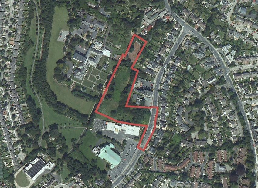
Figure 1: Location of the subject site (red arrow) to the southeast of Blackrock
The study area for this desktop assessment comprises the extent of the proposed development
site combined with an area extending for 500m from its boundary. There are no recorded
archaeological monuments located within the subject site, while the surrounding study area
contains only one recorded archaeological site which comprises the site of a demolished castle
(RMP ref no. DU023-008---) located c.485m to the north.
Newtownpark Avenue SHD, Blackrock, County Dublin
Desktop Archaeological Assessment 12. Methodology
Desktop study
A desktop study assessment has been carried out in order to identify all known archaeological
sites within the study area. The principal sources reviewed for this assessment of the known
archaeological resource are the Sites and Monuments Record (SMR) and the Record of
Monuments and Places (RMP). Between 1984 and 1992, the Archaeological Survey of Ireland
(ASI) issued a series of county SMRs which lists known archaeological sites and places and this
record formed the basis for the statutory RMP established under Section 12 of the National
Monuments (Amendment) Act 1994. Similar in format to the SMRs (comprising a list and set of
maps), the RMPs were issued for each county in the State between 1995 and 1998. Archaeological
monuments included in the statutory RMP are legally protected and are generally referred to as
‘Recorded Monuments’.
The ASI has continued to record and add entries to the SMR and has developed an online database
and web viewer known as ‘Historic Environment Viewer’. This has been developed to enhance
the user’s experience by facilitating access to the database of the National Monuments Service’s
Sites and Monuments Record (SMR) and the National Inventory of Architectural Heritage (NIAH)
in a seamless one stop point of access for both data resources (Source: www.archaeology.ie).
In addition, the following sources were consulted as part of the desktop study:
• Cartographic Sources - The detail on cartographic sources can indicate past settlement
and land use patterns in recent centuries and can also highlight the impact of modern
developments and agricultural practices. This information can aid in the identification of
the location and extent of unrecorded, or partially levelled, features of archaeological or
architectural heritage interest. The cartographic sources examined for the study area
include the First edition of the 6-inch Ordnance Survey (OS) maps (surveyed and
published in the 1830s-40s) and the 6-inch Cassini OS maps (surveyed and published
between 1830-1930).
• Aerial photography – In parallel with the cartographic study, a review publicly-accessible
aerial photographic sources from the Ordnance Survey, Google and Bing Maps was
undertaken.
• Development Plans - The local authority development plans relevant to the study area was
consulted as part of this assessment. These plans outline the local authorities’ policies for
the conservation of the archaeological and architectural heritage resource and include the
Record of Protected Structures (RPS) and any designated Architectural Conservation
Areas (ACAs). The relevant development plans for the study area are the Dún Laoghaire-
Rathdown County Development (2016-2022) and the Blackrock Local Area Plan 2015-2021
• Database of Irish Excavation Reports - The Database of Irish Excavation Reports contains
summary accounts of all archaeological excavations carried out in Ireland from 1960s to
present.
• Placenames Database of Ireland - The Placenames Branch (Department of Culture,
Heritage and the Gaeltacht) provides a comprehensive management system for data,
archival records and place name research conducted by the State. Its primary function is
Newtownpark Avenue SHD, Blackrock, County Dublin
Desktop Archaeological Assessment 2to undertake research in order to establish the correct Irish language forms of the place
names of Ireland and to publish them on a public website (www.logainm.ie).
• Irish Heritage Council: Heritage Map Viewer - This online mapping source collates various
cultural heritage datasets and includes extracts from the National Museum of Ireland’s
records of artefact discovery locations as well as datasets provided by, among others, the
National Monuments Service, local authorities, the Royal Academy of Ireland and the
Office of Public Works. Current data was accessed via www.heritagemaps.ie
• UNESCO World Heritage Sites and Tentative List - UNESCO seeks to encourage the
identification, protection and preservation of cultural and natural heritage around the
world considered to be of outstanding value to humanity. There are two world heritage
sites in Ireland and a number of other significant sites are included in a Tentative List
(2010) that has been put forward by Ireland for inclusion.
Newtownpark Avenue SHD, Blackrock, County Dublin
Desktop Archaeological Assessment 33. Context
Location
The proposed development site is located in the townland of Rockfield, approximately 1km
southeast of Blackrock town centre, in south County Dublin (Figure 2). The subject site is located
adjacent (to the west) of the R113 Newtownpark Avenue and was previously part of of the
grounds of Cluain Mhuire, a HSE-run care centre (formerly known as Rockfield House). The site
extends across a green field area measuring c.1.27ha and is L-shaped in plan and also includes a
portion of the public road (which straddles the townlands of Rockfield and Stradbrook). It is
bounded by Newtownpark Avenue at its south-eastern corner and remaining elements of the
Cluain Mhuire building complex and associated open space along its eastern margin. It is bounded
to the north by the rear gardens of residential houses and to the south by the Guardian Angels’
National School. The lands to the west form part of the Dunardragh and St Catherine’s complexes
which are under the ownership of the Daughters of Charity of St. Vincent de Paul. Aerial images
show the subject site to be overgrown with significant scrub and tree cover. Furthermore, two
confirmed areas of the site are known to be infested with Japanese Knotweed and a further area
zone of infestation has been identified.
Figure 2: Location of subject site (red outline)
Newtownpark Avenue SHD, Blackrock, County Dublin
Desktop Archaeological Assessment 4Legal & Policy Framework
The management and protection of cultural heritage in Ireland is achieved through a framework
of national laws and policies which are in accordance with the provisions of the Valetta Treaty
(1995) (formally the European Convention on the Protection of the Archaeological Heritage, 1992)
ratified by Ireland in 1997; the European Convention on the Protection of Architectural Heritage
(Granada Convention, 1985), ratified by Ireland in 1997; and the UNESCO Convention for the
Safeguarding of the Intangible Cultural Heritage, 2003, ratified by Ireland in 2015.
The locations of World Heritage Sites (Ireland) and the Tentative List of World Heritage Sites
submitted by the Irish State to UNESCO were reviewed and there are no such monuments located
within the study area. The nearest site on the tentative list to the proposed development site is
the Historic City of Dublin which is located c.8km to the northwest.
The national legal statutes and guidelines relevant to this assessment include:
− National Monuments Act (1930) (and amendments in 1954, 1987, 1994 and 2004);
− Heritage Act (1995);
− National Cultural Institutions Act (1997);
− Architectural Heritage (National Inventory) and Historic Monuments (Miscellaneous
Provisions) Act (1999);
− Planning and Development Act (2000);
− Architectural Heritage Protection: Guidelines for Planning Authorities, Department of Arts,
Heritage, and the Gaeltacht (2011); and
− Framework and Principles for the Protection of the Archaeological Heritage, Department of
Arts, Heritage, Gaeltacht and the Islands, 1999.
Archaeological Heritage
The administration of national policy in relation to archaeological heritage management is the
responsibility of the National Monuments Service (NMS) which is currently based in the
Department of Culture, Heritage and the Gaeltacht. The National Monuments Act of 1930, and its
Amendments, are the primary means of ensuring the satisfactory protection of the archaeological
resource. They include a number of provisions that are applied to secure the protection of
archaeological monuments. These include the designations of nationally significant sites as
National Monuments, the Register of Historic Monuments (RHM), the Record of Monuments and
Places (RMP), the Sites and Monuments Record (SMR), and the placing of Preservation Orders
and Temporary Preservation Orders on endangered sites.
Section 2 of the National Monuments Act, 1930 defines a National Monument as ‘a monument or
the remains of a monument, the preservation of which is a matter of national importance’. The State
may acquire or assume guardianship of examples through agreement with landowners or under
compulsory orders. Archaeological sites within the ownership of local authorities are also
deemed to be National Monuments. There are no National Monuments located within the study
area. The nearest National Monument to the subject site is Monkstown Castle (DU023-014001-)
which is located c.1.4km to the southeast.
The National Monuments (Amendment) Act, 1994 made provision for the establishment of the
RMP, which comprises the known archaeological sites within the State. The RMP, which is based
on the earlier Register of Historic Monuments (RHM) and Sites and Monuments Record (SMR),
provides county-based lists of all recorded archaeological sites with accompanying maps. All RMP
sites receive statutory protection under the National Monuments Act 1994 and the NMS must be
Newtownpark Avenue SHD, Blackrock, County Dublin
Desktop Archaeological Assessment 5given two months’ notice in advance of any work proposed at their locations. There is one
recorded archaeological monument within the 500m study area. This recorded
archaeological site is listed as the site of an unclassified castle (DU023-008---) and is located c.
480m to the north.
The relevant development plans for the study area are Dún Laoghaire-Rathdown County
Development (2016-2022) and the Blackrock Local Area Plan 2015-2021. The Dún Laoghaire-
Rathdown County Development (2016-2022) includes the following policies and objectives in
relation to the protection of the archaeological resource:
Policy AH1: Protection of Archaeological Heritage: It is Council policy to protect
archaeological sites, National Monuments (and their settings), which have been identified
in the Record of Monuments and Places (RMP) and, where feasible, appropriate and
applicable to promote access to and signposting of such sites and monuments.
Policy AH2: Protection of Archaeological Material in Situ: It is Council policy to seek the
preservation in situ (or where this is not possible or appropriate, as a minimum, preservation
by record) of all archaeological monuments included in the Record of Monuments and
Places, and of previously unknown sites, features and objects of archaeological interest that
become revealed through development activity. In respect of decision making on
development proposals affecting sites listed in the Record of Monuments and Places, the
Council will have regard to the advice and/ or recommendations of the Department of Arts,
Heritage and the Gaeltacht (DoAHG).
Archaeological & historical background
The Archaeological Survey of Ireland records no archaeological sites within the lands comprising
the proposed development area. The surrounding 500m wide study area contains only one
recorded archaeological site which comprises the location of an unclassified castle (RMP ref no.
DU023-088---) in the townland of Newtown, Blackrock (see Table 1 and Figure 3 below). This
castle, which was held by Walter Cheevers at the time of the Civil Survey in 1654-6, is no longer
extant with the site being built upon in the subsequent centuries. The structure which currently
occupies the site is depicted as 'Castle Byrn' on the 1843 first edition Ordnance Survey map and
Seapoint Manor on subsequent editions. This building is still extant but has been sub-divided in
recent times. The site of the original castle is scheduled for inclusion in the next revision of the
RMP.
Table 1: Recorded archaeological sites within 500m of the subject site (as recorded by the Historic
Environment Viewer of the ASI)
SMR No. Class Townland ITM (E, N) Distance
DU023-088---- Castle – Newtown, 721980, 729175 c.485m to NE
unclassified Blackrock
Newtownpark Avenue SHD, Blackrock, County Dublin
Desktop Archaeological Assessment 6Figure 3: Recorded archaeological monuments within a 500m radius of the proposed development site (red)
Prehistoric Periods
Until the recent identification of human butchery marks on a 12,000-year-old bear bone
recovered from a cave in County Clare, which places the discovery in the Palaeolithic period, the
earliest recorded evidence for human settlement in Ireland had dated to the Mesolithic period
(7000–4000 BC) when Stone Age hunter-gatherers travelling by boats landed on the heavily
forested island. While these Mesolithic settlers did not construct settlements or monuments that
have left any above ground traces, their presence can often be identified by scatters of worked
flint in ploughed fields. The Neolithic period (c.4000-2400 BC) began with the arrival and
establishment of agriculture as the principal form of economic subsistence, which resulted in
more permanent settlement patterns. As a consequence of the more settled nature of agrarian
life, new site-types, such as more substantial rectangular timber houses and various types of
megalithic tombs, begin to appear in the archaeological record during this period. The Irish
Bronze Age (c.2400–500 BC) commenced with the arrival of metal-working techniques to the
island and this technological advance resulted in the introduction of a new artefactual assemblage
into the Irish archaeological record. This period was also associated with the construction of new
Newtownpark Avenue SHD, Blackrock, County Dublin
Desktop Archaeological Assessment 7monument types such as standing stones, stone rows, stone circles, barrows and fulachta fia. The
arrival of iron-working technology in Ireland saw the advent of the Iron Age (c.600 BC – 400 AD).
This period has been traditionally associated with a Celtic ‘invasion’ but this view is no longer
widely accepted as recent archaeological evidence points instead to a gradual acculturation of the
Irish Bronze Age communities following centuries of contacts with Celtic-type cultures in Europe.
Relatively little has been traditionally known about Iron Age settlement and ritual practices until
recent decades when the corpus of evidence has been greatly increased by the discovery of Iron
Age sites during schemes such as bog-cutting and road construction projects.
Evidence for early prehistoric activity within Rockfield and the study area is scant and is largely
due to the fact that the area is now built up. Within the wider area recent archaeological
excavations at a site on the Merrion Road have identified two flints of particular note, a single
barbed and tanged arrowhead and a heavily utilised tertiary flint flake. The former may date from
the Beaker period, while the latter is possibly a Late Mesolithic Bann Flake (Baker, 2004). A
megalithic tomb site in Bullock (RMP DU023-018) which was removed at the beginning of the
nineteenth century (Ball 1902), and another on Dalkey Island (RMP DU023-029-10) indicates
that the region was more widely settled during the Neolithic period with the adoption of a farming
economy in Ireland (c.4000 –2400 BC). A single stone axe found at Monkstown is also likely to
date to this period (NMI ref. 1940:49). From the Early Bronze Age, both the mountains and coast
in south County Dublin were settled and greater material evidence of Bronze Age date (c.2400–
400 BC) revealed throughout the south County Dublin region indicates the popularity of the area
at that time. Much of this material evidence is represented by a variety of burial sites including
cist burials in Deansgrange (RMP DU023-042 and NMI ref. 1965:11), Stillorgan Park (RMP
DU023-050), Cabinteely (RMP DU023-036) and a number of burials on Dalkey Island (RMP
DU023-040). Cists are simple pits lined with stone flags that are sometimes accompanied by
pottery or other grave goods. Corpses can also be laid in so-called flat cemeteries which have no
above ground expression at all. An Early Bronze Age flat cemetery (DU023-012002) was revealed
in Stillorgan Grove during the construction of the Stillorgan house.
Medieval and Post-Medieval periods
The early medieval period (c. 400–1169 AD) began with the introduction of Christianity and
continued through the Viking and Hiberno-Scandinavian periods up until the arrival of the Anglo-
Normans in the late 12th century. The south County Dublin area was occupied in the 5th century
by the Dal Meisin Corb, an early Leinster sept whose power declined in the 7th and 8th centuries
and with whom a number of early saints in the locality claimed ancestry (O’Corrain 1972). In the
7th century, the area was known as the land of Cuala which was later divided into Ui Cellach
Cuallan and Ui Briuin Cuallan. By the 10th century, the area was in the control of a Viking clan
known as the Sons of Thorchill (Mac Niocaill 1972). By the time of the Norman invasion in 1169,
the whole area had come under the control of an Irish chieftain named MacGillamocholmog who
married the daughter of the then king of Leinster Dermot Mac Murrough.
The late medieval history of the study area is bound with the development of the manor of
Thorncastle, this incorporated the majority of the townlands within the study area. The lands
around Merrion had originally been granted to Walter de Ridelisford, lord of Bray. The area was
originally called Cnocro, meaning the red hill. Merrion seems to have been held in conjunction
with the manor of Thorncastle, which consisted of the lands between Merrion and Blackrock. The
lands passed to Christiana de Marisco, a minor; she eventually exchanged her lands in Ireland for
property in England and Merrion and Thorncastle passed into the hands of the crown at the end
Newtownpark Avenue SHD, Blackrock, County Dublin
Desktop Archaeological Assessment 8of the 13th century. The manor then passed into the hands of William le Deveneis, Remembrancer
of the Exchequer in Ireland. Subsequently, the lands passed to Walter de Islip and in about 1320
to Robert de Nottingham, mayor of Dublin. After his death the lands passed to Thomas Bagod
through his marriage to Nottingham’s widow. The manor passed into the ownership of Sir John
Cruise, the owner of lands in Stillorgan, in 1366 and from him into the hands of the Fitzwilliams,
whose main residence at this time was Dundrum, which they had held since the mid-14th century.
Merrion Castle was originally built by John Cruise but was enlarged and strengthened by the
Fitzwilliam’s.
Rockfield House is believed to have been constructed c.1760 with significant later remodeling
during the mid to late 19th and early 20th centuries. The subject site is located on Newtownpark
Avenue, a name which is derived from Newtown-in-the-Deer-Park, a village built in the deer park
belonging to Stillorgan House. Newtown is also an old name for Blackrock. The village of
Blackrock became an increasingly popular seaside retreat for the well-to-do of Dublin in the 18th
century and a large number of country houses and gentlemen’s residences were constructed on
its outskirts during this period.
Rockfield House was used as a summer residence by George Townshend (1724-1807) during his
tenure as Lord Lieutenant of Ireland (1767-1772) at which time the estate comprised c.200 acres.
Following Lord Townshend’s return to England the house and grounds were let to a number of
tenants on short term leases including Mr William Ralphson in 1776 followed by Thomas
Manning, Sir Frederick Flood, Edward Badham Thornhill and Sir Boyle Roche with Lady Louisa
Packenham residing at Rockfield between 1798 and 1803.
The first edition six-inch Ordnance Survey map (1836) depicts Rockfield House as a slightly
irregular L-shaped building surrounded by a demesne immediately west of present day
Newtownpark Avenue. The Rockfield demesne (which corresponds to the townland of Rockfield)
is bordered by the grounds of Stradbrook House to the east, Melfield to the south, Montpelier and
Templehill on the outskirts of Seapoint village to the north and the village of Blackrock with Proby
Square shown under development to the west . Further details of on the history of Rockfield house
are provided below.
Within the study area there are 14 buildings recorded under the National Inventory of
Architectural Heritage (NIAH), mostly to the south and east of the proposed development site.
The eastern façade and Newtownpark Avenue entrance of Cluain Mhuire (formerly known as
Rockfield House) is a protected structure as defined within the Dún Laoghaire – Rathdown County
Development Plan 2016-2022 (RPS ref. no. 776) and is also recorded within the National Inventory
of Architectural Heritage; NIAH ref. nos. 60230085 (house), 60230086 (Newtownpark Avenue
entrance) and 60230088 (Stradbrook Road entrance).
The Excavations Database
The Excavation Database contains summary accounts of all licensed archaeological investigations
carried out in Ireland (North and South) from 1969 to 2020. The database gives access to over
27,000 reports and can be browsed or searched using multiple fields, including year, county, site
type, grid reference, license number, Sites and Monuments Record number and author. No
archaeological investigations are listed on the data base for the Rockfield townland. Licensed
archaeological investigations (Licence numbers 03E0228, 08E0940, 09E236, 09E240, 13E0275
Newtownpark Avenue SHD, Blackrock, County Dublin
Desktop Archaeological Assessment 916E0083 and 16E0611) undertaken in the areas surrounding the proposed development site did
not reveal any potential archaeological features (see Appendix below).
Newtownpark Avenue SHD, Blackrock, County Dublin
Desktop Archaeological Assessment 104. Description of site
A review of available aerial imagery detailing the proposed development site was carried out as
part of this assessment. The proposed development site is shown as a largely undisturbed,
overgrown greenfield site with frequent shrub and tree growth evident, with the exception of the
northernmost portion which aerial imagery shows to have been disturbed within the last decade.
As previously noted, the subject site is L-shaped in plan with the western side of site running
north to south along the boundary with St Teresa’s convent. To the south is the Guardian Angel’s
National School and to the north is the rear garden of a residential property. The eastern
boundary has three sections; the most southerly portion bounds Newtownpark Avenue and an
amended existing access to the service yard will provide vehicular and pedestrian access for the
proposed new housing development, the middle section of the eastern boundary abuts the
grounds/surface carparking to the front of Cluain Mhuire, and finally, the northern end of the
eastern boundary abuts the rear gardens of no.’s 21, 19, 17, 15, 13 and 11 Newtownpark Avenue.
The site has substantial tree cover and most of the significant trees are in the southern end of the
site, in particular immediately south and west of Cluain Mhuire. In this area they appear to have
been deliberately planted but there are trees and shrubs throughout the site, some of which are
of more recent growth. It appears the site has been fenced off from the grounds of Cluain Mhuire
for a significant period. North of the site entrance Newtownpark Avenue has a signal controlled
junction with Stradbrook Road. South of the site entrance is the Guardian Angels National School
and, adjoining that, an associated large church with extensive surface car parking surrounding it.
Figure 6: Aerial image showing approximate site boundary (source: Google Earth)
Newtownpark Avenue SHD, Blackrock, County Dublin
Desktop Archaeological Assessment 11It is noted that there are two confirmed infestations of Japanese Knotweed recorded within the
site (Invasive Plant Solutions 2019). At the time of writing, it is proposed the treatment of
Japanese Knotweed infested soils at this site will be through bio-secure removal and offsite
disposal.
Newtownpark Avenue SHD, Blackrock, County Dublin
Desktop Archaeological Assessment 125. Conclusions and recommendations
This desktop archaeological assessment was undertaken in order to assess the archaeological
potential of a proposed residential development site at Rockfield, Blackrock, County Dublin. The
assessment has revealed that there are no recorded archaeological sites (as recorded by the
Historic Environment Viewer of the ASI) located within, or in immediate proximity to, the
proposed development site. The nearest recorded archaeological site (DU023-008---; Castle –
unclassified) is located c.485m to the north of the proposed development site. As such, there will
be no impacts to the recorded archaeological heritage resource as a result of any proposed works
within the subject site.
Six licensed archaeological investigations have been undertaken within the study area, none of
which revealed anything of archaeological significance. No potential archaeological features were
noted within the subject site on either the historic OS map editions or recent aerial images. Aerial
images indicate that the northern portion of the proposed development site has been disturbed
by ground works which were undertaken within the last decade. However, the subject site can be
considered to possess a moderate archaeological potential. This consideration has been made
due to the undeveloped and predominantly undisturbed nature of the subject site and the
attractiveness of the general location for habitation during historic and prehistoric times.
Due to the potential for the disturbance of unrecorded archaeological remains, it is recommended
that should the project proceed, all ground clearance and topsoil stripping works be subject to a
programme of licensed archaeological monitoring. Given the presence of two confirmed
infestations of Japanese Knotweed, it is not possible (or even advisable) to undertake pre-
development archaeological testing.
Newtownpark Avenue SHD, Blackrock, County Dublin
Desktop Archaeological Assessment 136. References/sources
Published works
Ball, F. E, (1903) A History of County Dublin Part Second. Dublin
Ball, F.E, (1900) ‘The Antiquities from Blackrock to Dublin’ in Journal of the Royal Society of
Antiquaries vol. 30.
Invasive Plant Solutions (2019) ‘Review of on-site Japanese Knotweed and associated
remediation costs: Proposed development site at Cluain Mhuire, Newtownpark Avenue,
Blackrock, Co. Dublin’, an unpublished report by Invasive Plant Solutions, Dundrum,
County Tipperary
Joyce, W. S, J, (1912) Neighbourhood of Dublin. Monkstown
Lewis, S. 1837 A Topographical Dictionary of Ireland, 2 vols, London: Samuel Lewis & Son.
Internet resources
Database of Irish Archaeological Excavations, accessed 18/03/2020,
http://www.excavations.ie/
Department of Culture, Heritage and the Gaeltacht’s Historic Environment Viewer, accessed
21/10/2020, http://webgis.archaeology.ie/historicenvironment/
Irish placenames, accessed 18/03/2020,
http://logainm.ie
Dunlaoghaire - Rathdown County Development Plan (2016-2022)
https://www.dlrcoco.ie/en/planning/county-development-plan/county-development-plan-
2016-2022 (accessed 18/03/2020)
www.heritagemaps.ie (accessed 18/03/2020)
National Inventory of Architectural Heritage
www.buildingsofireland.ie (accessed 18/03/2020)
Ordnance Survey Ireland
www.osi.ie (accessed 18/03/2020)
Thom’s Irish Almanac and Official Directory with the Post Office Dublin City and County Directory
www.askaboutireland.ie (accessed 18/03/2020)
https://www.youwho.ie/rockfield.html (accessed 18/03/2020)
Cartographic resources
Ordnance Survey Ireland Licence No. SU 0003320 (© Ordnance Survey Ireland/Government of
Ireland).
Map data ©2019 Google
Newtownpark Avenue SHD, Blackrock, County Dublin
Desktop Archaeological Assessment 14Appendix: Relevant Excavations.ie entries
Site Name Licence No. Summary
Martello Tower, 03E0228 (Chris Archaeological monitoring of renovation works associated with
Seapoint, Dublin Corlett) the Martello tower uncovered the original stone floor of the
tower and the foundations of internal dividing walls. The Tower
is one of a series of fortifications erected between 1804 and
1805 along the 25 mile stretch of south Dublin coast from
Sandymount to Bray.
Leopardstown, 08E0940 (Dáire In an effort to combat water leakage, Dublin City Council is
District Metered Leahy) upgrading water mains throughout the city. Depending on the
Area (Newtown proximity to recorded monuments and the technique being
Park used, portions of this were conducted under archaeological
supervision. Monitoring of works in the Leopardstown DMA
was carried out in December 2008. Nothing of archaeological
significance was uncovered during the course of these works.
Blackrock 09E240 The Dublin Region Watermain Rehabilitation Project is an
(Daire Leahy & initiative intended to tackle the high level of water leakage from
Garrett Sheehan within the water distribution network. The project will seek to
identify those areas of watermain infrastructure yielding the
greatest sustainable water savings throughout the Greater
Dublin Region (GDR). The GDR for the purposes of the project
consists of the county council areas of Dublin City, Fingal, South
Dublin, Dun Laoghaire–Rathdown and parts of Kildare and
Wicklow. To date, the project has recommended mains in 55
DMAs for rehabilitation.
On the basis of the techniques which were to be used, a series of
five scenarios for determining the level of monitoring were
agreed with the City Archaeologist and the National Monuments
Service. In March 2009 these scenarios were reviewed and
amended on the basis of the results of the monitoring on this
project to date. As a result of this review only two scenarios
necessitated archaeological attendance. In Scenario 1, where
open-cut trench excavation is carried out within 30m of
RMP/within ZAP, full-time monitoring is required if there is no
existing main within the trench; intermittent monitoring is
required where the trench is excavated over an existing main.
The second scenario requiring monitoring is Scenario 5: where
any excavation technique is to be used within 10m of a National
Monument, full-time monitoring is required.
There are four archaeological monuments within the Blackrock
DMA: a Martello tower (DU023-002) on the coast, a cross at the
Main Street in Blackrock village (DU023-005), and the site of a
possible castle (DU023-008) and holy well (DU023-009) on the
south-eastern edge of the DMA. All four RMPs are located
Newtownpark Avenue SHD, Blackrock, County Dublin
Desktop Archaeological Assessment 15Site Name Licence No. Summary
directly within those areas that were to be subjected to
watermains rehabilitation.
While a licence had been issued for monitoring in 2009, the bulk
of the groundworks associated with the DMA were not carried
out until 2011. Therefore an extension to the licence was
granted in March 2011. Monitoring of works in this DMA was
carried out on occasions between January and June 2011. The
works that formed part of the Blackrock DMA consisted of
monitoring in the vicinity of the cross (DU023-005) at the
junction of Main Street, Carysfort Avenue and Temple Road and
in the vicinity of the holy well (DU023-009) in Maretimo
Gardens East.
The process of rehabilitation involved either the exposure of the
existing watermain or the excavation of a new trench for a new
pipe (new-lay). This was generally carried out with the use of a
mechanical excavator of either JCB type or a smaller ‘mini-
digger’ type. Where necessary, some of the trenches were also
excavated by hand.
The works undertaken in the vicinity of the cross consisted of
mainly open-cut trenches. The trenches measured
approximately 0.5m in width and ranged from approximately
0.6m to 1m in depth. In some cases larger areas were opened to
expose the junction between a number of watermains.
Following the removal of the upper surface of tarmac, the
underlying hardcore/sand was removed. Below this the entire
trenches were backfilled with modern deposits containing
modern ceramics and building waste. Neither material nor
features of an archaeological nature were exposed during the
excavation of these trenches. The work in Maretimo Gardens
East was initially intended to be open-cut but upon the
excavation of trial pits it was decided to undertake pipe-
bursting. A trenchless technique was employed in the vicinity of
the Martello tower (DU023-002) along Seafort Parade.
No archaeological features, deposits or artefacts were revealed
during monitoring of these groundworks.
St Brigid’s Parish 09E0236 Pe-development testing was carried out at a proposed extension
Church, Church (Michael to the graveyard at St Brigid’s Parish Church, Church Road,
Road, Stillorgan Tierney) Stillorgan, Co. Dublin. It was proposed to extend the existing
graveyard into the rectory garden, creating 44 new grave plots.
Two parallel test-trenches were excavated 5m apart and
orientated north-east to south-west along the entire 28m length
of the site. No finds, features or deposits of archaeological
significance were identified during these works.
Newtown 13E0275 (Faith Monitoring was carried out as part of the redevelopment at
Castlebyrn Bailey) Newpark Comprehensive School, Newtownpark Avenue,
Newtown Castlebyrn, Blackrock, Co. Dublin. The work was
Newtownpark Avenue SHD, Blackrock, County Dublin
Desktop Archaeological Assessment 16Site Name Licence No. Summary
carried out in response to planning conditions attached to the
development by Dun Laoghaire Rathdown County Council
(Planning Ref.: D10A/0234) and An Bord Pleanála (Ref. No.: PL.
06D.238095). Monitoring was undertaken intermittently
between 18 July and 19 August 2013. Nothing of archaeological
significance was identified during the course of works.
Fitzerald Park, 16E0611 Monitoring of the topsoil stripping and associated groundworks
Monkstown (Deirdre Murphy was carried out between 14 December 2016 and 28 January
and Robert 2017. No archaeological features or deposits were identified
Breen) during monitoring and no finds were recovered.
Newtownpark Avenue SHD, Blackrock, County Dublin
Desktop Archaeological Assessment 17You can also read