8 TECHNICAL GUIDANCE ON CONTAMINATED SITES Version 3 Effective date: January 5, 2021
←
→
Page content transcription
If your browser does not render page correctly, please read the page content below
8
                                                          TECHNICAL GUIDANCE
                                                             ON CONTAMINATED SITES
                                                                    Version 3 Effective date: January 5, 2021

         Groundwater Investigation and Characterization
Introduction                                         When is groundwater investigation
This document provides guidance to qualified         necessary?
professionals for the investigation and              Site investigation stages
characterization of groundwater at sites in          The Regulation contains requirements to ensure
British Columbia that may be, or are,                that groundwater at a site or on a neighboring
contaminated. It is the responsibility of the site   site is suitable for use and is of adequate quality
owner or operator to retain a qualified              to protect uses now and in future. Where site
professional with demonstrable experience, as        investigations must be undertaken, section 58
required under section 63 of the Contaminated        (1) of the Regulation requires that a preliminary
Sites Regulation (the Regulation), to ensure that    site investigation (PSI) be undertaken to
groundwater is properly characterized and            determine the general location and degree of
remediated while adhering to applicable B.C.         contamination, including any migration that
laws, regulations, standards, protocols,             may have occurred to neighbouring properties.
procedures and guidance.
                                                     The PSI comprises a Stage 1 review and a
This guidance is based on the ministry’s full        concurrent or subsequent Stage 2 where
length companion document entitled                   relevant environmental media are sampled for
“Technical Guidance for Contaminated Sites.          potential contaminants of concern (PCOCs). If
Groundwater Investigation in Site Assessment,        contamination is identified or suspected then a
2nd Edition”, dated June 17, 2010 [1]. Both this     detailed site investigation (DSI) must be
guidance document and the companion                  undertaken in accordance with section 59 (2) of
document should be used as part of any               the Regulation to define the extent of
contaminated site groundwater investigation.         contamination, to provide information
                                                     necessary for conducting a risk assessment, if
The guidance and procedures outlined here are        applicable, and to develop a remediation plan.
not applicable at every site; others may also be
used. However, deviations from this guidance         Groundwater investigation triggers
or use of alternative methods must be                Groundwater investigation is necessary if the
accompanied by documented, defensible                potential exists for the quality of groundwater
rationale.                                           to be unsuitable for direct use, based on
                                                     groundwater uses at the site, or may not be
                                                     adequate to protect adjacent groundwater uses.

                                                                                                           1
Groundwater investigation is also necessary        compared to accurate and reliable groundwater
where groundwater is acting as a source of         quality data that represent, to the greatest
contamination in other environmental media         extent practical, the quality of the groundwater
such as vapour. In practice, where areas of        at a site.
potential environmental concern (APECs) are
identified by a Stage 1 PSI, relevant              The conceptual site model
environmental media must include                   For effective planning of any site investigation,
groundwater, which should be sampled as part       the historical, physical, chemical and biological
of the subsequent Stage 2 PSI and/or DSI. If       components that define a problem should be
groundwater is not sampled, detailed               drawn together into a conceptual site model
supporting rationale for its exclusion must be     (CSM). In a hydrogeological context, the CSM
provided in the PSI or DSI report.                 should comprise a three-dimensional
                                                   understanding of the site to be investigated.
What are B.C.’s groundwater quality                The CSM should be developed at the outset of
classes?                                           the investigative process and refined
Based on its use, the Regulation provides four     throughout the course of the investigations to
classes for groundwater:                           strengthen and clarify the site understanding.
    DW – drinking water                            At the completion of investigations, the CSM
    AW – aquatic life protection                   should, as a minimum, include key
    IW – irrigation water                          hydrogeologic features and properties such as:
    LW – livestock watering                        •   the physical geologic setting including the
                                                       known or inferred extent and continuity of
Aquatic life protection standards are further          all aquifers and aquitards that are beneath
subdivided into standards to protect freshwater        and in the vicinity of the site that are or may
aquatic life and standards to protect marine and       be of relevance;
estuarine aquatic life.
                                                   •   groundwater levels (pressure heads, water-
                                                       table elevations, potentiometric surfaces)
Numerical standards for many potential
                                                       and hydraulic gradients (vertical and
contaminants in water are listed in Schedule 3.2
                                                       horizontal) within and between relevant
of the Regulation. Monitoring results may be
                                                       permeable geologic units;
compared directly to the substance
concentrations in these schedules to determine     •   the physical and hydrogeologic boundaries
whether a groundwater source is in compliance          that define the groundwater flow systems of
with applicable water use standards. Guidance          interest, including recharge and discharge
for selecting water uses is provided in Protocol       areas, pumping wells, hydraulic and
21, “Water Use Determination”.                         physical no-flow boundaries or divides, and
                                                       other relevant conditions;
How should a field program be designed?            •   the locations and character of onsite and
A well-designed field program will yield a data        relevant offsite potential source zones of
set composed of representative physical and            contamination to groundwater, including
chemical information on soil, vapour, sediment,        any nonaqueous phase liquids (NAPL) if
groundwater and surface water conditions               present, and their composition, nature, and
obtained from a number of locations and                extent;
depths at various times. It is important that      •   the locations, extent and character of
applicable groundwater standards are                   associated dissolved-phase plumes of
                                                                                                     2
contamination that may exist; and acceptable means to acquire representative
• all pathways for contaminant transport from groundwater samples for Stage 2 PSIs and DSIs.
source zones to known or potential Such wells are commonly composed of a riser
receptors, including pathways that may pipe inserted into a drilled borehole, with a
convey nonaqueous phase, dissolved-phase screened completion interval at the base that is
or vapour-phase plumes that may be placed within a targeted geologic unit. A
expected to develop in the future. recommended design for conventional
monitoring wells is provided in the “British
The CSM must be supported with a data set Columbia Field Sampling Manual”.
derived from sound investigative practices, as The use of drill cuttings as backfill is to be avoided.
provided in this and other guidance Recommended sealants along the well annulus
documents, and any pre-existing information or include non-shrinking bentonite-based grouts or
data that have been identified and can be relied solids. In cases where granular bentonite, bentonite
upon. Supporting rationale should be provided chips, or bentonite pellets are used, proper hydration
of the bentonite during placement should be ensured,
for such data. Depending on the level of site particularly if the sealing material is located in the
complexity, the CSM may be portrayed unsaturated zone. Any deviation from these
together with descriptive text in a set of plan requirements should be identified in site
maps and stratigraphic cross sections or fence investigation reports, together with supporting
diagrams. As part of the CSM, key processes rationale.
that may significantly influence the presence,
distribution and fate of potential contaminants In addition to the design, installation and
of concern at a site (e.g., advection, dispersion, sampling of a network of conventional
retardation, ion exchange, precipitation, monitoring wells, a variety of screening-level
dissolution, diffusion, volatilization and approaches and multi-depth tools are available
biodegradation) should be identified and that can be used during the PSI and DSI to
described where available data make such complement groundwater data and identify the
assessments possible. presence, absence or extent of groundwater
contamination. These range from simple
What methods and approaches are descriptive observations of continuous cores of
acceptable for groundwater field soil or rock, to direct-push profiling tools such
investigations? as laser-induced fluorescence tools, the
A range of direct and indirect approaches is membrane interface probe, or the Waterloo
available to acquire information on Profiler™. These approaches may be used to
groundwater quality (e.g., CCME’s guidance complement data obtained using conventional
manual for environmental site characterization monitoring wells.
[2] and Attachment B of the companion
document to this guidance [1]), any of which Vertical contaminant distribution
may be acceptable for use in B.C. However, it is In aquifers where groundwater contamination
critical that the field investigation include the may exceed one to two metres in thickness,
acquisition and analysis of representative groundwater quality profiles should be defined
using clusters or nests of wells completed at
groundwater samples.
different depths, or by using other groundwater
Obtaining groundwater quality information profiling technologies. Alternative approaches
Conventional monitoring wells that are to conventional monitoring wells include
properly installed and sampled provide an various tools and technologies that can be
demonstrated to yield reliable quantitative or
3semi-quantitative information on groundwater Where a water table aquifer is monitored, the
quality either directly (e.g., direct-push screen length should not extend beyond a
groundwater sampling technologies such as the depth of one metre below the greatest depth to
Waterloo Profiler™), or indirectly through the water table as defined by the seasonal
acquisition of soil quality profiles in situ (e.g., minimum and/or minimum groundwater
using technologies such as laser-induced elevation during low tide.
fluorescence or a membrane interface probe) or
ex situ (e.g., analysis of discrete soil samples or The use of wells with long screen intervals may
extracted fluid samples from soil cores). be acceptable for exploratory purposes during a
Stage 2 PSI (but not a DSI) provided that cross
Obtaining hydrogeologic information
communication between potentially separate
Hydrogeologic information should be acquired
groundwater zones is avoided. However,
through drilling, well installation, and well
where saturated well screen intervals exceed 1.8
monitoring and testing programs, or through m, chemical data for samples from such wells
alternative approaches that yield comparable should not be compared directly with
site-specific data. Soil and/or rock core groundwater quality standards unless
samples are usually obtained and used to supporting rationale can be provided.
describe physical aquifer conditions, and
hydraulic tests or measurements are made to Wells that are no longer being used or that are
acquire hydraulic information about the inadvertently screened across more than one
aquifer. Field tests may range from simple aquifer should be decommissioned promptly
static water-level measurements that can be (i.e., at or before the completion of a site
used to assess the water table or piezometric investigation), to avoid risk of future cross
surface of the aquifer, to more involved aquifer contamination.
pumping tests that hydraulically stress a region
of the aquifer, and thereby allow estimation of What level of groundwater investigation is
local and/or regional-scale hydraulic required for a preliminary site investigation?
parameters (e.g., hydraulic conductivity, Stage 1 preliminary site investigation
transmissivity, specific yield, storativity). Groundwater investigation should begin
during Stage 1 of a PSI and should include
Well development, purging and sampling attempts to acquire geological,
A description of well development, purging hydrostratigraphic and groundwater use
and sampling methods to be used in the information about the site and vicinity (refer to
investigation of groundwater conditions and Technical Guidance 10, “Guidance for a Stage 1
quality at contaminated sites is provided in Preliminary Site Investigation”). If APECs are
Attachment A of the companion document [1]. identified, then the assembled information
should be evaluated to assess the potential for
Acceptable lengths of monitoring well screens contamination of the environmental media,
Maximum saturated screen lengths should be including groundwater. To assist with this
limited to 1.8 m (i.e. screen plus filter pack) evaluation, a CSM should be developed with a
within the target hydrostratigraphic unit. hydrogeologic focus. It will also serve as a
Preference should be given to smaller intervals basis for planning the next phase of the field
so that maximum concentrations are better investigation, the Stage 2 PSI.
defined. Rationale must be provided where
longer well screen lengths with greater Stage 2 preliminary site investigation
The type and scale of investigation selected and
saturated thicknesses are used.
implemented during a Stage 2 PSI, and the
4media to be sampled, will be highly dependent present, and where unforeseen high-
on local site conditions and on characteristics of permeability features such as buried gravel
the potential contaminants of concern (PCOC). channels or utilities are present.
The success of the program will depend on the
degree of understanding of these conditions as At the completion of the Stage 2 PSI,
described by the CSM. A well-developed CSM information should be presented and
is likely to better achieve Stage 2 PSI objectives conclusions drawn regarding the presence or
than a program based on limited information absence of groundwater contamination
that has not been cohesively assembled within a associated with each APEC. In addition,
logical framework. Where site-specific confirmation of the groundwater flow
information is lacking but groundwater quality hypotheses that were used to base the inclusion
is to be addressed, a Stage 2 PSI could consider and exclusion of potential APECs during the
the drilling and logging of a “stratigraphic” Stage 1 PSI should be conducted. Where the
borehole, located beyond all zones of potential groundwater flow information determined
contamination, to establish site-specific
during the Stage 2 PSI differs from that inferred
stratigraphic conditions and to identify target
in the Stage 1 PSI, the Stage 1 PSI conclusions
intervals for further testing (e.g., water table,
with respect to APEC selection should be re-
saturated geologic units, and aquifers).
examined. The CSM should also be updated.
During the Stage 2 PSI, monitoring well
locations should be selected to intercept highest If groundwater is identified as contaminated,
concentrations of potential contaminants in then recommendations for further assessment
groundwater associated with each suspected in the form of a DSI should be provided.
source zone within each on-site APEC, and at
the property boundary as close as practical to Conditions requiring further investigation
off-site APECs. If underground utility Further assessment in the form of an expanded
corridors exist, a review of the utility location Stage 2 PSI or DSI should be conducted where:
maps and depth information is required to • groundwater is identified as contaminated,
assess the presence of preferential pathways or,
near APECs and aid in determination of well • a well or set of wells is determined to have
locations. missed the highest concentrations of a
possible plume because the well(s) is not
Groundwater flow direction should be located directly downgradient of the
established as part of the Stage 2 PSI and used potential source zone.
to re-assess the optimum sampling locations
with respect to anticipated highest Further assessment should also be considered
concentrations. Groundwater flow direction where PCOCs have been detected in
should be estimated using water-level groundwater and the water quality data are
measurements acquired from a minimum of limited to a few data points.
three locations arranged in a triangular plane
within the same hydrogeologic unit (i.e., the What level of groundwater investigation is
same aquifer). Caution is advised, however, required for a detailed site investigation?
where groundwater flow patterns are complex. As required in section 59 (2) of the Regulation, a
Data from more than three wells will likely be DSI must, among other items, include
necessary to resolve flow directions where, for procedures to identify the specific areas, depths
example, groundwater mounding results in and degree of contamination on the site,
radial flow, where diving or sinking plumes are including areas and extent of migration if
5applicable, and evaluate contamination relative stratigraphic layering that is likely present.
to standards in the Regulation. For purposes of
this guidance, and except where a Stage 2 PSI In the absence of site-specific rationale, data to
report has concluded that groundwater is not define and bound the vertical extent of a plume
contaminated, groundwater assessment must should be derived from locations that are
be undertaken during the DSI. The sampling separated vertically by no more than one metre
program must be sufficiently detailed to satisfy from the bottom of one well or sampling point
data requirements for a risk assessment, if and the top of the next, within each aquifer of
applicable, and for developing a remediation interest (Appendix 1, Figure 1). Where
plan. monitoring wells are used, care must be taken
to select a small enough screened interval to
Well spacing and spatial characterization avoid cross-communication between aquifers,
For groundwater investigation during a DSI,
or even between significant stratigraphic layers
the following guidance is provided to ensure
within the same aquifer.
that plumes of contamination are identified and
characterized with reasonable certainty. An Chemical characterization
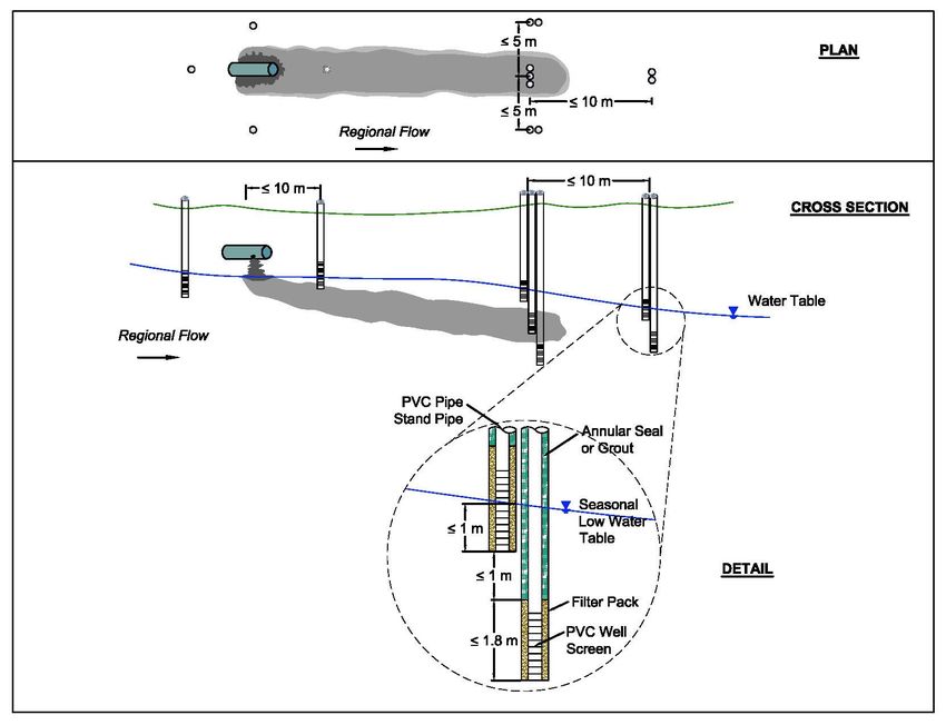
example of acceptable well spacing intervals The detailed site investigation should include
and well completion depths for a groundwater the chemical analysis of representative samples
plume is illustrated in Appendix 1, Figure 1. As for appropriate substances and parameters at
each site is unique, variations from this the appropriate detection limits.
guidance are to be expected. However, any
deviation from the requirements presented
The suite of substances selected for a site
below must be identified, together with
investigation should include the following:
supporting rationale and consequent
• contaminants of known or potential
implications on the uncertainty of the acquired
concern, modifying factors (pH or hardness)
data set.
that are used to establish the applicable
standard for certain contaminants, and the
The site assessment should characterize
substance concentrations with reasonable potential transformation products in the
certainty so that: subsurface that may pose risks to receptors.
• all groundwater plumes of significant size
In addition, the substance suite may also
(typically 10 m or longer longitudinally, 5 m
include the following:
or wider laterally, and 0.1 m or thicker
• inorganic constituents (more commonly
vertically) are identified with reasonable
major ions, and less commonly dissolved
certainty such that the horizontal and
gases and/or isotopes) that may assist in
vertical boundaries are resolved at the scale
addressing the hydrogeologic
identified in Appendix 1, Figure 1; and
characterization, and
• the effects of well screen length and dilution
at the location of a potential receptor are • geochemical and chemical information that
understood and taken into account in the will assist in assessing contaminant
investigation. transport and fate in the subsurface (e.g.,
redox conditions, soil and dissolved organic
Vertical separation between wells
Where a groundwater plume is confirmed or carbon content, dissolved oxygen and pH,
suspected, it should be resolved to a vertical nutrients, hardness, etc.) during migration
scale that is compatible with the scale of the through the aquifer to a receptor.
6In some cases (e.g., sites with long term
Temporal characterization monitoring data or monitoring coupled with
Several factors may account for observed remediation efforts), other means of
changes in substance concentrations over time, evaluation/lines of evidence could be used to
including changing water levels caused, for demonstrate plume stability as follows:
example, by changes in seasonal infiltration
rates or tides, and changes resulting from • A minimum of one year of quarterly
biotransformation or source depletion. groundwater monitoring and
geochemical data (including assessing
The site investigation should obtain a sufficient groundwater conditions over the range
number of samples to establish the magnitude of seasonal/temporal variations),
of temporal concentration variations or to allow coupled with other methods of
predictions to be made with reasonable evaluation/lines of evidence that in sum
certainty. Where seasonal effects may be demonstrate plume stability (e.g.,
significant, or where concentrations are likely to partial/complete source removal,
vary significantly for other reasons, then at least conservative modelling, etc.).
quarterly sampling should be performed over
at least one year. Trend analysis (e.g., Mann-Kendall test, α=0.05)
of the monitoring data used to support the
Preferential transport pathways demonstration of stable or decreasing
All site investigations should address the concentrations within and at the margins of the
possibility of contaminant transport along contaminant plume is required as part of
preferential pathways such as utility corridors assessment of plume stability.
and drainage improvements. This will involve The plume stability assessment must be carried
a review of utility location maps and depth out by a qualified professional with
information, which can then be compared with demonstrable experience in (a) assessment of
known information concerning the site groundwater flow, contaminant fate and
stratigraphy, water table elevations, and transport, and aqueous geochemistry, and (b)
presence and extent of contamination. trend analysis.
Plume Stability Assessment
The demonstration of stable or decreasing Hydrogeologic information
contaminant plumes must include the Defining site-specific hydrogeologic conditions
evaluation of groundwater conditions within In addition to defining the presence,
and at the margins of contaminant plumes and distribution and fate of the contaminants,
provide evidence of both stable or decreasing groundwater investigations during a DSI
substance concentrations throughout and no should also define site-specific hydrogeologic
additional vertical or lateral migration or conditions including:
rebound effects. A minimum of two years of • the presence, extent and properties of
groundwater monitoring and geochemical data aquifers and aquitards underlying the site
(including seasonal variations over a two-year that are or may be of relevance;
period) demonstrating stable or decreasing
• zones of high hydraulic conductivity that
groundwater concentrations and conditions is
may act as preferential transport pathways,
expected to be collected.
and zones of low conductivity that may
impede or redirect transport;
7• unconfined and confined aquifers; Erroneous measurements
• vertical and lateral hydraulic gradients, Outliers
groundwater flow direction and velocities Where the data allow, contouring should be
within and between the relevant, permeable conducted within the context of the CSM, with
geologic units; particular attention paid to “outliers” that may
become apparent during contouring. Potential
• physical and hydrogeologic boundaries that
or probable causes for the outliers should be
define the groundwater flow systems of
described. Some common causes for outliers
interest, including recharge and discharge
include, for example, data acquired from wells
areas, pumping wells, hydraulic or physical
completed with long well screens and/or at
no flow boundaries or divides, and other
different depths within the aquifer, where
relevant conditions; and
vertical hydraulic gradients are present within
• event and seasonal contributions to the
the aquifer, or where wells are installed across
hydrogeologic regime as well as tidal
more than one aquifer or groundwater flow
influence (where appropriate), with a focus
zone. These types of well completions are not
on identifying conditions required for
encouraged as they may yield non-
sampling to be conducted such that it is
representative water-level data and also may
characterizing as close to the “worst case”
allow flow between zones and serve as conduits
scenario as reasonably possible.
allowing contaminant migration between the
The investigation of groundwater flow zones.
direction and velocity should, at a minimum,
Light Nonaqueous Phase Liquids (LNAPL)
include the following:
The presence of LNAPL in a well may also
• all wells should be surveyed with reference yield erroneous measurements of water
to an elevation datum (a geodetic datum is elevation. Where significant floating NAPL is
preferred, although a site-specific reference present (i.e., greater than a few centimetres),
datum is acceptable), information on
• static water levels should be measured on LNAPL thickness must be factored in to
the same day from monitoring wells at determine the actual groundwater elevation, to
several locations within the same aquifer, account for the density difference between the
and, LNAPL and groundwater.
• the groundwater elevation data should be
calculated and tabulated. Short-term changes
Estimates of groundwater flow direction may
Entry of information into drawings also be influenced by short-term changes in
Groundwater elevation data should be posted water elevation or hydrostatic pressures in
on drawings and, where sufficient data are confined or unconfined aquifers caused, for
available, contoured in plan view for each example, by tidal fluctuations or changes in
aquifer of interest. Potentiometric surfaces river stage during spring freshet. In such cases,
should be shown for each aquifer on each water levels in an aquifer should not be
stratigraphic cross section. The flow direction considered static, and one or two simple
in each aquifer should then be estimated with “snapshot” measurements of water levels in
respect to the data and data contours, and wells from a site are unlikely to yield reliable
shown on the drawings. data for estimating average groundwater flow
direction or velocity.
8development. The presence and thickness of
Where multiple hand measurements of water any immiscible layers in a well should be
levels cannot be readily obtained from site established prior to purging and sampling
monitoring wells over a full tidal cycle (i.e., at using a reliable technique such as an interface
sites with more than three or four monitoring probe. In those wells with NAPL, groundwater
wells) water-level data should be acquired from sampling is not advisable since measured
individual wells using automatic measurement concentrations may often be lower than actual
devices such as pressure transducers. The time- dissolved concentrations due to sample
step interval between measurements and
dilution, or higher than actual concentrations
monitoring duration should be commensurate
due to entrainment of NAPL in the samples.
with the expected rate of change of water level.
For most tidal conditions, measurement
Characterization of the NAPL is usually best
frequencies should be once per hour, over
periods of at least 71 hours. In most cases, data achieved by direct sampling and analysis,
reduction and interpretation will require although assessment of dissolved-phase
smoothing to establish mean or average constituents can often be used successfully to
conditions over the monitoring period. Where infer NAPL composition. NAPL sampling
tidal influence is present, the method of Serfes, involves the careful use of special bailers or
1991 [3] is recommended to yield estimates of pumps. Acceptable monitoring approaches are
mean water levels at individual monitoring described by API, 1996 [4].
points. However, in a complex hydrogeologic
setting (e.g., highly variable fill soil and/or LNAPL monitoring
preferential flow channels) examination of the Where subsurface contamination by LNAPL is
pressure transducer data at specific points in suspected, monitoring wells should be
time may also be of value in describing the designed so that the well screen interval
groundwater flow system. straddles the water table, thereby allowing
LNAPL, if present, to enter the well. If the well
In cases where the site is located in proximity to may be used for long-term monitoring
a marine environment, saltwater intrusion is purposes, then the well screen length should be
very probable. Accordingly, deeper wells may selected to straddle the water table over the
be screened within a saltwater wedge, whereas anticipated seasonal high and low water-table
shallower wells may be screened within conditions.
freshwater. Water-level data obtained from
wells screened within saltwater must be Where LNAPL is present, at least one LNAPL
corrected for density contrasts and converted to monitoring well should be placed within each
equivalent freshwater head. This conversion is zone where LNAPL is inferred to be thickest.
critical to properly evaluate vertical and The lateral boundary of the LNAPL zone
horizontal hydraulic gradients, and to should be resolved at a scale of 5 m to 7 m or
accurately characterize groundwater flow when less, depending on proximity of LNAPL to
constructing potentiometric surface maps. property boundaries, structures and other
sensitive site features. Data to define the
When should nonaqueous phase liquids be boundary may be acquired using various
investigated? technologies such as monitoring wells, laser-
The presence of NAPL should be monitored induced fluorescence, soil cores or test pits.
during drilling, well installation and well However, some LNAPL monitoring wells
9should be installed in downgradient locations to establish the influence of tides on LNAPL
along the perimeter of the LNAPL zone to presence and thickness.
monitor LNAPL thickness and the possibility of
LNAPL migration. During the monitoring period and until a well
is decommissioned, its integrity should be
Following well development, LNAPL may not checked and maintained, including maintaining
enter the well immediately. Therefore, the well effective well plugs and seals to prevent cross-
should be allowed to rest at least 24 hours and contamination.
preferably at least one week before confirming
the presence or absence of LNAPL. Where Dense nonaqueous phase liquid (DNAPL)
monitoring
LNAPL is present, a regular monitoring
Where subsurface contamination by DNAPL is
program should be established for at least 12
suspected, care should be taken to avoid
months (or as long as necessary to assess NAPL
drilling through the DNAPL, which may cause
migration) or until remediation has been
the contamination to migrate deeper into the
undertaken or LNAPL is demonstrated to be
subsurface. DNAPL distributions in the
immobile under the criteria specified in Section
subsurface are often highly complex, and as a
3.2 of Protocol 16, “Determining the presence of
result, direct evidence of DNAPL is rarely
and Mobility of Nonaqueous Phase Liquids and
obtained using conventional drilling and
Odorous Substances”. In absence of site-
sampling techniques. Thus, a precautionary
specific rationale, the monitoring frequency at
approach to investigation of DNAPL zones is
each LNAPL well should be at least once every
advised, and alternative investigation
two months and preferably monthly until the
approaches should be considered to assess the
temporal variability and mobility of LNAPL
extent of contamination. These may include
has been established, for the following:
using multi-depth sampling at locations
• Total organic vapour concentrations at the
immediately downgradient of the DNAPL zone
well head using a photoionization detector
and obtaining soil vapour and shallow soil data
or similar field instrument.
mainly from the surface of the zone. Using
• Water and product levels using a reliable
these indirect approaches, the outer horizontal
method such as an interface probe.
boundary of the suspect DNAPL zone should
Based on the results of this investigative phase
be inferred to a reasonably small scale (5 m to 7
of monitoring, the monitoring frequency can be
m, where practical), depending on proximity of
reduced to quarterly if warranted.
DNAPL to property boundaries, structures and
other sensitive site features. The vertical extent
Groundwater concentrations from wells located
of the suspect DNAPL zone should be resolved
downgradient of the LNAPL plume should be
to a depth interval of 1 m to 2 m. For further
analyzed to evaluate potential LNAPL
information on DNAPL assessment, please
movement. A temporal increase in dissolved
refer to Pankow and Cherry (1996) [5] and
concentrations downgradient of the plume may
USEPA (2004) [6].
be indicative of LNAPL advancement;
conversely, a temporal decrease in dissolved
What types of information should be
concentrations may be indicative of LNAPL reported?
plume retreat. Groundwater investigation reports should
include a description of the methodology used
At tidally influenced sites, monitoring should to evaluate site hydrogeology and
be conducted over a full tidal cycle at least once
10hydrogeochemistry and the rationale for the extraction or injection wells) should not be used
methods used. Summaries of key information for evaluation of post-remediation groundwater
should be provided in tables and on figures as a quality.
means to convey relevant information. A
checklist for data information requirements is Substances to be monitored
provided in Appendix 1. Groundwater should be monitored for
contaminants of concern as well as
What degree of groundwater investigation is transformation products and constituents that
required for confirmation of remediation? may have been mobilized by the remediation
Where groundwater is to be remediated, (e.g., metals dissolution in response to low
remediation planning must consider where and redox conditions caused by enhanced in situ
how monitoring will be conducted and how the biodegradation of petroleum hydrocarbons).
data will be used to confirm that the
remediation objectives have been achieved. Monitoring frequency
Where trends are to be established, the
Confirmatory sampling and monitoring
frequency of monitoring should be based upon
Confirmatory sampling and monitoring
known hydrogeologic conditions, including
locations should be established taking into
estimated groundwater and contaminant
consideration a number of factors including:
transport times, and data requirements.
• the known extent of contamination;
• the groundwater flow direction before Minimum requirements
remediation; A remediation monitoring program will be
• the possibility and duration of short-term different for every site. However, the following
changes in groundwater levels resulting items are minimum requirements to confirm
from the remediation (e.g., temporary low groundwater remediation:
water levels following remediation); • A monitoring network should be established
• where active groundwater controls are that includes a minimum of three
required, changes in groundwater flow are monitoring locations within each affected
long-term and result in new steady state aquifer associated with each area of
conditions which need to be confirmed; groundwater contamination.
• transitioning periods in water levels or • Each groundwater monitoring station
groundwater chemistry until long-term or (usually a monitoring well, but alternative
steady-state conditions are re-established; technologies may be equally effective) from
the designated network should be
• expected transport velocities and travel
strategically located within the remediation
times between remediated areas and
zone or along its immediate perimeter,
monitoring locations; and
within the relevant permeable geologic
• changes in geochemical conditions such as
units. Installation by placement of post-
redox potential that may affect the solubility
remediation monitoring wells during
or mobility of some constituents.
excavation backfilling is to be avoided.
Post remediation monitoring locations should
• Groundwater levels and groundwater
be selected to include locations that will
quality indicator parameters (i.e.,
intercept each of the zones most likely to
temperature, electrical conductivity, pH,
contain highest concentrations of the
redox potential, dissolved oxygen, and
contaminants. Note that remediation wells (e.g.
11turbidity) should be monitored before each and long term average or mean concentrations
sampling event to verify that static at individual well locations.
conditions have been attained. As a
minimum subset, pH, electrical conductivity When and how should monitoring wells be
plus one additional parameter should be deactivated or closed?
monitored until they have stabilized. Monitoring wells that no longer serve their
• Once static conditions have been attained, at intended purpose, such as wells that may
least two sets of groundwater samples remain at the completion of a site investigation
should be collected on different days, at or remedial monitoring program, should be
least 24 hours apart, but preferably greater properly deactivated and closed. Minimum
than two weeks apart, where practical. At requirements for well deactivation and closure
sites where seasonal effects may be are provided in section 56 of the Water
significant, at least two sets of groundwater Sustainability Act [7] and in section 9 and
samples should be collected to capture the Appendix A (Code of Practice for Construction,
full range of seasonal variations. Testing, Maintenance, Alteration and Closure of
Wells in British Columbia) of the Ground Water
• Representative samples should be analysed Protection Regulation [8].
from all designated locations or wells for the
contaminants of concern and for possible References
contaminants that may have resulted as a
direct or indirect consequence of the 1. Golder Associates Ltd., 2010. Technical
remediation. Guidance for Contaminated Sites. Groundwater
Investigation in Site Assessment.
When is post remediation groundwater
monitoring considered complete? 2. Canadian Council of Ministers of the
Post remediation groundwater monitoring may Environment (CCME), 2016. Guidance
be considered complete when substance Manual for Environmental Site Characterization
concentrations are less than applicable in Support of Environmental and Human Health
standards, concentrations can be shown to be Risk Assessment. Volume 1 Guidance Manual.
stable or decreasing, and where rebound can be
discounted. 3. Serfes, M.E., 1991. Determining the Mean
Hydraulic Gradient of Groundwater Affected by
When is long term groundwater monitoring Tidal Fluctuations. Groundwater, V.29, No. 4.
necessary? pp. 549-555.
With many sites where remediation is
undertaken, groundwater quality may not 4. American Petroleum Institute (API), 1996. A
improve immediately, or improvements may Guide to the Assessment and Remediation of
not immediately meet applicable standards. In Underground Petroleum Releases, API Pub.
such cases, long term monitoring will be No. 1628A, American Petroleum Institute,
necessary either to establish trends towards Washington D.C., First Edition.
meeting the remediation objectives or to
provide sufficient data to demonstrate that the 5. Pankow, J.F. and J.A. Cherry (eds.), 1996.
standards are met over time regardless of Dense Chlorinated Solvents and Other DNAPLs
changes in water levels or groundwater flow in Groundwater, Waterloo Press, Portland,
direction. Statistical approaches may be useful OR.
to establish trends in concentration, periodicity,
12For more information, please direct enquiries to
6. U.S. Environmental Protection Agency site@gov.bc.ca
(USEPA), 2004. Site Characterization
Technologies for DNAPL Investigations. EPA
542-R-04-017. Solid Waste and Emergency Revision history
Response (5102G). Approved Effective Document Notes
Date Date Version
July 2010 February 1.0
7. Province of British Columbia, 2014. Water 1, 2011
Sustainability Act [SBC 2014] CHAPTER 15, August November 2.0 Updated for
Chapter 483, Queen’s Printers. 2017 1, 2017 CSR Stage
10/11
amendments
8. Province of British Columbia, 2009. Ground December January 5, 3.0 Included plume
2020 2021 stability
Water Protection Regulation (GWPR), B.C. expectations
Reg. 299/2004, including amendments up to
B.C. Reg. 91/2009, March 6, 2009.
13Appendix 1.
Guidance for Data Presentation
Borehole and Well Construction Logs
Logs should be provided for all geotechnical wells, boreholes, and all wells and
piezometers, presenting complete technical records of conditions encountered, scaled to
depths of at least 0.1 m. Logs should contain, at a minimum:
• Site name and location
• Name of driller and onsite professional
• Borehole number and location coordinates
• Start date, completion date, date abandoned or completed as monitoring well
• Borehole depth
• Ground surface elevation, top of casing elevation (for wells)
• Sample type, depth and depth interval for all in situ samples
• Sample condition, percent recovery, and other field data (e.g., blow counts,
moisture content)
• Materials classification (based on field and laboratory descriptions using the
unified soil classification system (USCS; ASTM D2487 and/or ASTM D2488) or
equivalent
• Observations including colour, stains, odours
• Drilling observations such as loss of circulation, heaving sands
• Volume and quality of water added during drilling
• Depth to water following drilling
• Water level and date following well completion
Raw data from in situ hydraulic tests and copies of laboratory analytical certificates
should be provided.
Tables
Tables should be provided that include, at a minimum summaries of all field and
laboratory data acquired from current and previous investigations, including:
• Water level depths and elevations along with screened interval elevations; and
• Analytical chemistry results for each environmental medium compared with
relevant environmental quality standards
14Figures and Drawings
Figures and drawings should include, at a minimum:
• A scaled regional location plan and site plan, showing relevant hydrological,
topographical and physiographic features
• A plan of posted data at measurement locations, and contours, where sufficient
data are available, of piezometric heads in each aquifer of interest
• Stratigraphic cross sections that are longitudinal and transverse with respect to
the known or estimated groundwater flow direction, and that include physical
conditions (e.g., stratigraphy, water table, piezometric surface elevations),
location and depth of all boreholes, monitoring wells and well screen intervals
falling on or near the section, and vertical and horizontal scales
• Posted data at measurement locations, and contours where sufficient data are
available, in plan and cross section views, of substance concentrations that show
the specific lateral and vertical distribution of either each contaminant of concern
or a representative set of contaminants of concern in onsite and offsite soil and
groundwater
• Sample locations (with corresponding analytical results used to develop each
figure) that are shown on the figure and in tabular form with reference to
applicable standards.
Other
• Field sampling sheets should be provided documenting information such as
volume of water purged, observations during purging, and relevant field-
measured parameters (e.g. electrical conductivity, temperature, pH, dissolved
oxygen, redox potential, etc.)
The Contaminated Sites Services Application form, Part E, provides further instructions
on key information requirements to be provided on figures where applications for
contaminated sites services are to be made for detailed review by Ministry of
Environment staff.
15Figure 1. Example illustrating acceptable well spacing intervals and well completion depths to
define the vertical and lateral extent of a plume of groundwater contamination.
Note. The number of wells used to define the internal plume size and the spacing
between these wells may vary from site to site.
16You can also read