Developing the Concept of a Marine Cadastre: An Australian Case Study
←
→
Page content transcription
If your browser does not render page correctly, please read the page content below
Developing the Concept of a Marine
Cadastre: An Australian Case
Study

ANDREW BINNS
andrew@sunrise.sli.unimelb.edu.au

ABBAS RAJABIFARD
abbas.r@unimelb.edu.au

PHIL A. COLLIER and
p.collier@unimelb.edu.au

IAN WILLIAMSON
ianpw@unimelb.edu.au

Department of Geomatics
The University of Melbourne
Parkville, Victoria 3010, Australia.

Abstract
In the terrestrial environment, it is the cadastre and initiatives such as the creation of Spatial Data Infrastructures (SDI) that
are facilitating greater decision making in areas of sustainable development. The ability of such tools and initiatives to
facilitate effective decision-making and spatial data access mechanisms within the marine environment has given rise to
research into a marine cadastre. Such a cadastre aims to define, visualise and realise legally defined maritime boundaries and
the rights, restrictions and responsibilities attached to them.

                                                    -1-
1. Introduction
The world’s oceans cover almost two thirds of the surface of the earth, regulating weather patterns and producing a huge
variety of plant and animal life (UN, 2003). Given the diversity of this area, there is an economic, social and environmental
need to effectively manage it. Current policy and institutional frameworks for the governing of this ocean territory are
complex, with government legislation and international treaties such as the United Nations Convention on the Law of the Sea
(UNCLOS) needing to be considered (Collier et al., 2001). Underpinning this legislative framework is the complex
relationship and interaction between overlapping and often competing rights, restrictions and responsibilities of stakeholders
both in the marine environment and at the land-sea interface.
Based on this situation, a framework such as a marine cadastre needs to be created, in order to provide the foundation from
which management issues, including the global focus on sustainable development within the marine environment, can be
addressed. The term cadastre has not been readily used in the marine environment, but according to Neely et al. (1998), many
of the cadastral components such as adjudication, survey, and owner rights have a parallel condition in the ocean. A closer
inspection of Australia’s cadastral system however shows that there are also many differences that would need to be overcome,
if the terrestrial cadastre concept was to be applied to the marine environment.
The continuing development of Spatial Data Infrastructures (SDI) as a tool to facilitate access and maintenance of data within
the terrestrial environment is also beginning to spread to the marine environment. Within Australia, the Australian and New
Zealand Land Information Council (ANZLIC, the nations peak spatial information body), has recommended that the Australian
SDI (ASDI) incorporate spatial information relating to all of Australia, including the marine environment. This would go a
long way to aiding the creation of a seamless ‘on-land off-shore’ cadastre for the country.
Before a marine cadastre can be conceptualised however, it is important to fully understand the sustainable development issues
that are driving its development. The current systems in place to manage marine boundaries and rights also need to be
assessed, in order to identify the technical, legal and institutional issues and arrangements that are hindering the coordination
of effective marine management. International perspectives on the management of maritime boundaries and associated rights,
restrictions and responsibilities must also be considered. This paper aims to describe the concept of a marine cadastre through
the use of an Australian case study, based on current research being undertaken in the Department of Geomatics at the
University of Melbourne.
2. Factors & Issues Driving the Development of a Marine Cadastre
It is accepted that the interests of a nation do not stop at the land-sea interface. The economic, environmental and social
impacts that this realization is having on the marine environment are just beginning to be felt, with competition for the vast
array of natural resources ever increasing. Added to this is the implementation of the United Nations Convention on the Law of
the Sea, which came into force in 1994. This has given rise to the need for more efficient and effective maritime boundary
management techniques to be put in place within maritime jurisdictions.
One of the main drivers in implementing a marine cadastre comes from the environmental movement and the effect it has had
on politics and society. Issues of pollution, depleted marine resources and increased threat by man to the health of the marine
environment are forcing governments such as Australia’s to implement sustainable development measures. According to the
Australian Fishing Management Authority (AFMA, 2000), 70% of all marine pollution comes from land based activities and
according to the FAO, “nine of the world’s 17 fisheries are in serious decline, with four depleted commercially” (PANOS,
1995). There is also international pressure to implement legal and institutional mechanisms to support sustainable
development. For this to be achieved however, new approaches to marine and coastal area management and development are
required (Robertson et al., 1999).
The marine environment is subject to as many pressures as the terrestrial environment and recognition of its actual and
potential value as an economic resource is rapidly developing (Widodo, 2003). Industries such as oil and natural gas
exploration are two examples of major sources of revenue for both government and private industry, with competition
increasing for control over marine areas with vast arrays of natural resources. This makes the effective management and
delimitation of coastal areas increasingly important.
There is also a growing awareness of the need to recognize the rights that indigenous people have to both land and sea, with
international initiatives and domestic court rulings giving increased focus to the indigenous peoples movement (Robinson and
Mercer, 2000). Indigenous Australians were in possession of Australia before British settlement in 1788, but property and
rights were not recognized by the government, when it pronounced Australia as terra nullius, or land belonging to no-one. It
was not until the countries 1992 High Court decision in Mabo v. the State of Queensland, that it was judged to have been done
“wrongfully, without compensation and contrary to the spirit of British property law” (Reynolds, 2000).
In 2001, indigenous rights to the sea and sea-bed were formally recognized in Australia with the High Court ruling that non-
exclusive native title existed in the offshore region of the Croker Island, off the coast of the Northern Territory (Robertson,
2002). Although a victory for the indigenous people, the existence of such rights makes it difficult to effectively manage
native title areas under current spatial management systems, driving the need to introduce a framework such as a marine
-2-cadastre, in order to facilitate a greater degree of cooperation between stakeholders.
The ability to utilise spatial data in managing such environmental and social factors is currently hindered by a focus on data
‘silos’. Data management agencies collect and disseminate data individually and without consultation amongst themselves.
This encourages marine data to be held in varying formats and at varying accuracies within ‘silos’. The integration of datasets
thus becomes much harder, hindering the ability of management agencies to make up-to-date and informed decisions.
There are also various legal, institutional and technical issues which need to be addressed in the creation of a marine cadastre.
2.1 Legal Issues
The current legislative arrangements for the management of a nation’s maritime zones involve not only UNCLOS, but also a
complex web of federal legislation. Within an Australian context for example, the National Oceans Office (NOO, 2002a) has
identified roughly 600 pieces of state, Territory and Commonwealth legislation which currently manage ocean use and
ecosystem health in Australian waters. This is on top of over 50 international treaties and conventions that the country must
take into account. Australia also has in place the Offshore Constitutional Settlement (OCS), a legal tool that enables offshore
jurisdictional responsibility to be shared between the nation’s states and Commonwealth government. An example of this is the
management of offshore mining, with the relevant Commonwealth Acts conferring day-to-day administrative responsibilities
to the states (Rothwell and Haward, 1996).
The ability of legislation to effectively govern stakeholder activities in the marine environment is currently hindered by a
degree of ambiguity throughout much of it. An example can be found when dealing with the definition of “high water”, the
boundary to which property and council rights extend within most nations. Within one piece of legislation as an example, high
water is defined as “the mean height of the higher tide at spring tides”, and within another as “the ordinary high water mark at
spring tides”, as seen in Table 1 below. Defining such ambiguous terminology will promote greater understanding of the
issues and promote easier communication and enactment of effective legislation. This was highlighted in the recent UNB-FIG
marine cadastre meeting (UNB-FIG, 2003).
Q LD D e p a rt m e n t o f h ig h F IS H E R IE S A C T 1 9 9 4 - " h i g h w a te r" m e a n s t h e m e a n
P rim a ry In d u s t rie s w a te r S E CT 4 h e ig h t o f t h e h i g h e st h i g h w a te r
a t sp ri n g ti d e .
Q LD D e p a rt m e n t o f h ig h M A R IN E P A R K S (C A IR N S " h i g h w a te r" m e a n s t h e m e a n
P rim a ry In d u s t rie s w a te r ZO N IN G P L A N ) O R D E R h e ig h t o f t h e h i g h e r ti d e a t sp ri n g
1992 - S E CT 2 ti d e s;
In t e rp re t a t io n
Q LD E n viro n m e n t a l h ig h C O A S TA L P R O TE C TIO N " h i g h w a te r m a rk " m e a n s t h e
P ro t e c t io n A g e n c y w a te r A ND M A NA G E M E NT A CT o rd in a ry h i g h w a te r m a rk a t
m a rk 1995 - S CHE DULE 2 sp ri n g ti d e s.
Q LD D e p a rt m e n t o f h ig h M A R IN E P A R K S " h i g h w a te r" m e a n s t h e M e a n
P rim a ry In d u s t rie s w a te r (W O O N G A R R A ZO N IN G H i g h W a te r S p ri n g (M H W S ) ti d e
P LA N) O RDE R 1991 - le ve l;
S CHE DULE 1
Table 1 – Definitions of high water – (Based on Finney, 2002)
The ability of stakeholders to identify which legislation applies to their particular activity is also an issue, as the way in which
spatial descriptions are embedded within legislation varies and is often hard to understand. This is due to two factors. The first,
is that older legislation which has not been updated uses an outdated system of delimitating boundaries, which is not accurate
enough to make an informed decision as to where a boundary is spatially. The second fact is that generally, people who write
legislation do not have a spatial background. Even when legislation is updated, the spatial data community is not always asked
to comment on how to accurately describe boundaries. Both of these factors can result in ambiguous spatial definitions of
geographic areas or boundaries in legislation in the marine environment.
2.2 Institutional Issues
The volume and nature of stakeholder activity in the marine environment is different to that on land. In the majority of cases,
the rights of stakeholders in the marine environment can overlap often creating competing rights, restrictions and
responsibilities. This creates the need for cooperation between managing agencies that does not always occur. Often, such
agencies are in isolation from one another, creating data ‘silos’ which do not encourage the sharing of spatial information.
Hence managing agencies do not have clear spatial certainty of each other’s rights, restrictions and responsibilities. According
to a report from the FIG-UNB meeting on the marine cadastre in 2003, there needs to be a whole of government approach to
the management of marine space, including input from academia, native groups and communities, in order to overcome such
competing rights (Sutherland, 2003).
-3-This lack of spatial certainty is compounded by the inability to gain access to up-to-date and accurate spatial information on
stakeholder activity in the marine environment. This limits the ability to make speedy and informed decisions. The collection
and dissemination of spatial data is often timely and expensive, and without the cooperation of all stakeholders, the same type
of data could be collected by a variety of agencies.
The spatial data that is collected in the marine environment also needs to be compatible with data collected from the terrestrial
environment. This is due to the fact that there can be jurisdictional confusion over the management of the land-sea interface or
coastal zone, an example being local governments managing land to High Water Mark (HWM), and state governments
managing the marine environment from the Low Water Mark (LWM). If a marine cadastre is to be implemented, it needs to
be compatible with its land based counterpart. This would bridge the gap between the terrestrial and marine environments,
aiding in coastal environmental and planning issues such as:
- Development planning for various types of urban, industrial and tourism activities;
- Waste disposal management from local farms, coastal residents, tourist or recreational users, which have outlets or run-off
into the marine environment;
- Public health and safety issues involving oil companies, local residents and other marine users;
- Environmental issues between local residents, fisheries and environmental organisations
- Commercial and recreational fishing activities within and around marine parks;
- Commercial harvesting of living and non-living natural resources.
(Widodo, 2003)
The key to bridging this gap and addressing other institutional problems is the creation of a lead agency in the marine
environment. This agency would be responsible for facilitating an overarching framework for a nation’s oceans, providing
guidance on access to spatial information and addressing issues of both state and national importance.
2.3 Technical Issues
The discontinuity between the land and marine environments is compounded by the inability to accurately define tidal datums
such as Low Water Mark, which are used to determine the baselines from which the boundaries between international,
national, state and private rights are created. This influences the ability to accurately map coastal and shoreline areas, as tidal
ranges can vary from almost zero to hundreds of meters in coastline areas. As mentioned in the discussion of legal issues
effecting the marine environment, the language used to describe such tidal datums also varies, adding further confusion to the
ability to define and map coastal areas.
The Low Water Mark is also the boundary from which a nation’s Territorial Sea Baseline (TSB) is drawn, the line from which
maritime boundaries are created. The ambulatory nature of the TSB, due to the constantly changing nature of the coastline,
means that it needs to be consistently updated. The Australian Maritime Boundary Information System (AMBIS) is a good
example of a system that provides access to data for Australia’s TSB and maritime zones (AUSLIG, 2001, Widodo, 2003) and
would need to be part of any marine cadastre initiative. It is the best available information, is maintained and freely available
and updated regularly. There is however legal uncertainty in regards to the boundaries contained within AMBIS and the
quality of the data varies, relative to the capture method and source (Robertson, 2002).
The other major technical issue is the three dimensional nature of the marine environment, with different activities occurring
on the surface of the ocean, across the water column and beneath the sea-bed. There are also instances where a fourth
dimension (time) is added. An example of this is in the regulation of seasonal fisheries which open and close during various
times of the year. The modelling of such 3D and 4D spatial characteristics is a major hurdle to the development of a true
spatial representation of rights, restrictions and responsibilities in the marine environment, which the marine cadastre aims to
accomplish.
The issues described above can often lead to competition and conflicting interests between users. In order to address these
problems, stakeholders should have clear spatial and legal certainty of their rights, restrictions and responsibilities in the
marine environment. The utilization of spatial data through the development of a SDI is one way in which to achieve such
certainty.
3. Spatial Data Infrastructure and the Marine Cadastre
Spatial data are items of information that can be related to a location on the Earth, and range from information on natural
phenomena issues such as topography and geographic features to administrative and property boundaries (Rajabifard, 2002).
The need for spatial data is continually increasing and changing, with more than 80% of governmental data having a locational
basis (Rajabifard, 2002). The SDI concept has evolved, in order to facilitate and coordinate the exchange and sharing of such
spatial data between stakeholders from different jurisdictions
The concept and components of SDIs are still evolving, however (Rajabifard et al., 2000) state that the important principle of
SDIs is that they provide an environment which enables a variety of users to access and retrieve complete and consistent data
-4-sets easily and securely. The common components of an SDI (Figure 1) have been identified as Data, People, Access Network
and Standards.
Access Network
People Policy Data
Standards
Figure 1 – Components of SDI
In Australia, the objective of developing the ASDI is to create a national infrastructure that enriches the nation’s investment in
spatial data and improves economic, social, environmental and defence decision making. ANZLIC have welcomed proposals
by sections of the marine data community to include marine and coastal data as fundamental data themes in the ASDI
initiative. This will provide mechanisms to access spatial data required to support such decision making in the marine
environment. It will also maximise the access, use and integration of spatial data, avoid duplication in its acquisition and
maintenance, and clearly define custodianship of principle datasets (Warnest et al., 2002).
The creation of a marine cadastre aims to enable collaboration through the utilisation of SDI principles in addressing
sustainable development objectives, pulling together the various technical, legislative and institutional issues discussed in this
paper. For this to become reality however, there is a need to foster greater relationships between agencies, governments and
countries involved in marine cadastre related initiatives.
4. International Perspective
The nature of the marine environment demands that research initiatives not be developed in isolation. They must be user
driven, with collaboration from various governments, the private sector and researchers. The development of marine cadastral
systems for the sustainable management of resources is evident in a range of countries such as Canada, the United States of
America, New Zealand and the Netherlands (Nichols et al., 2000); (Fowler and Treml, 2001); (Grant, 1999); (Barry et al.,
2003), with the main focus on the USA and Canada.
One of the common threads between all of these countries is the similarities faced in attempting to effectively manage offshore
areas. This is particularly so when comparing Australia, USA and Canada. There are multiple and unclear jurisdictional
boundaries, various co-management arrangements between state and federal governments, no one agency managing offshore
rights and boundaries, indigenous title rights and enormous maritime areas to manage.
In order to address this, the USA’s Coastal Centre of the National Oceanic and Atmospheric Administration (NOAA), in
conjunction with various industry, government and academic collaborators have developed a prototype Ocean Planning
Information System (OPIS). This is the first kind to apply cadastral data toward integrated ocean planning, with the overall
goal being to “provide easy access to comprehensive ocean-related data and information that will enhance regional, integrated
approaches to coastal and ocean resource management” (NOAA, 1998a). The system’s major features include:
• an interactive mapping application;
• marine and coastal spatial data download tools;
• associated metadata; and
• legal summary pages.
The system draws together spatial components that can be of importance in balancing conflicting uses of resources within the
marine environment.
A project undertaken in Canada has focussed on identifying marine limits and boundaries from which a conceptual framework
for “good ocean governance” can be developed. According to Ng’ang’a et al. (2001), other biological, economic and
environmental information could be linked to such a framework, giving it a multipurpose cadastral function.
This concept of a multipurpose marine cadastre was recently presented at a meeting on the marine cadastre in Fredericton
Canada. While most participants agreed that the marine cadastre’s primary focus should be on legally defined spatial extents
and associated rights, interests, restrictions and responsibilities, they also desired greater access to a variety of information,
something that a multipurpose marine cadastre would aid in providing (UNB-FIG, 2003).
Although international marine cadastre initiatives are a useful guide to some of the current problems and issues relating to the
possible design and implementation of a nation’s marine cadastre, it is not possible to simply adapt a blanket model. A
-5-solution which is unique, but also takes advantage of current international research into the marine cadastre is required, as
shown within the Australian case study below.
5. Case Study : Australia
5.1 Australia’s Current Marine Management System
Australia is a profoundly maritime nation, with approximately 99% of trade carried by ship (NOO, 2002b). Australia’s
coastline is almost 60,000km in length and the area of the nation’s maritime responsibility is over twice that of its continental
landmass (Kaye, 1995). The Australian Maritime Jurisdiction (AMJ) – the region to be covered by any future marine cadastre
– is the second largest in the world and represents a vitally important natural asses and responsibility.
In recent years, there has been an increasing awareness of the importance of spatial data in managing Australia’s offshore area.
This has included the need for a structured and consistent approach to the definition and maintenance of offshore legal
boundaries. It is in this context that the concept of a national marine cadastre has gained increasing prominence and strong
government support (Rajabifard et al., 2003). Healthy coordination of the research effort is being maintained through the
nurturing of close collaborative links between the government and academic sectors.
The ability to sustainably manage and develop Australia’s marine environment is of a high priority. The environmental,
economic and social dimensions that this entails have forced countries such as Australia to review their current management
systems, to identify issues and areas which need to be addressed or improved, in order to facilitate more cooperative
management arrangements between stakeholders and users of the marine environment.
Australia operates under a Federal system of governance, with areas such as health, education and land administration
managed by the state, and monetary, defence, foreign affairs, immigration and trade issues administered by the Commonwealth
(Dalrymple et al., 2003). This division of jurisdictional responsibility also occurs within the marine environment, with the
states and Northern Territory holding sovereign jurisdictional responsibility from the Low Water Mark out to a limit of three
nautical miles (called Coastal Waters). The Federal jurisdiction begins from this point and extends out to the Territorial Sea
boundary at 12 nautical miles, which is the legal limit of Australian sovereignty (Figure 2). The various maritime zones that
Australia has declared under the guidance of UNCLOS are explained in Table 2.
Figure 2: Australian Maritime Zones (AUSLIG, 1999)
-6-Zone D efin itio n C o astal S tate Ju risd ictio n
T he line from w hich the seaw ard lim its
of A ustralia's m aritim e zones are
T errito rial S ea m easured, theoretically the line of
B aselin e (T S B ) Low est A stronom ical T ide (LA T ).
W aters from the T S B out to a lim it of
three nautical m iles (defined by the Jurisdiction rests w ith the states and N orthern
C o astal W aters S tate) T erritory. N ot defined under U N C LO S .
B and of ocean adjacent to the
coastline, the outer lim it of w hich does A ustralia has full sovereign rights w ithin this
not exceed 12 nautical m iles from the area, w ith the exception that it m ust allow
T errito rial S ea TSB. foreign ships the rights of innocent passage.
B and of ocean adjacent to the
territorial sea (12nm ), w ith the outer A ustralia does not have sovereign jurisdiction
lim it of the contiguous zone not over this area, although is does have the right to
exceeding 24 nautical m iles from the enforce its custom s, fiscal, im m igration and
C o n tig u o u s Z o n e TSB. sanitary law s and regulations.
A rea stretching from the lim it of the
E xclu sive territorial sea (12nm ) out to and not A ustralia has the right to explore and exploit the
E co n o m ic Z o n e exceeding 200 nautical m iles from the living and non-living resources of the w ater
(E E Z ) TSB. colum n, seabed and subsoil.
A nation m ay gain rights to an
extended continental shelf beyond the
200 nautical m ile lim it, up to 350
nautical m iles from the T S B , subject to A ustralia w ould gain seabed and subsoil rights
E xten d ed the provisions of A rticle 76 of to any areas of an extended continental shelf
C o n tin en tal S h elf U N C LO S . granted under U N C LO S .
Table 2 – Australia’s Maritime Zones (Based on UN 1997)
The final jurisdictional area illustrated in Figure 2 and described in Table 2 is the Continental Shelf. A coastal State such as
Australia, can apply to the United Nations to extend its rights to the marine environment past its EEZ to a distance of 350
nautical miles. Under UNCLOS, “the coastal State exercises over the continental shelf sovereign rights for the purpose of
exploring and exploiting its natural resources”, enabling Australia to increase its economic gain in the marine environment. If
such an extension is to be granted however, the coastal State must accurately define the new area, and demonstrate a capability
and intent to administer it in terms of sustainable development obligations (Robertson et al., 1999). The development of a
framework such as a marine cadastre would aim to aid in facilitating decision making in order to meet such obligations.
5.2 ARC Marine Cadastre Project
The major Australian marine cadastre research initiative is currently an Australian Research Council (ARC) funded two year
project based in the Department of Geomatics at the University of Melbourne, which aims to define a marine cadastre for
Australia. Such a cadastre is now being recognised as a fundamental initiative utilising an offshore spatial data infrastructure.
In essence, the marine cadastre would aim to provide a means for delineating, managing and administering legally definable
offshore boundaries and associated rights, restrictions and responsibilities.
As part of this collaborative initiative, two pilot project areas have been adopted and are currently supporting the development
and testing of research findings and are also helping to demonstrate the concept and complexities of a future marine cadastre.
Work is also being conducted to gain a broader understanding of the requirements of those individuals and organisations who
use, manage and administer maritime spaces and marine spatial data. This is being achieved through the running of workshops,
the conducting of a broadly based national questionnaire and the execution of detailed industry consultation.
Current research under this project is focussed on two main areas. The first area of research focuses on issues of 3D and 4D
parcel definition, the application of uncertainty in maritime boundary delimitation and coastline definition, and the integration
of uncertainty within a multi-dimensional cadastral object model. The second area is a consideration of the similarities and
differences between the existing land cadastre and a future marine cadastre and the suitability and extension of the ASDI to the
marine environment.
Building on the findings of current research and by supporting strategic industry-academic partnerships, a new grant has been
provided by the Australian Research Council (ARC) to allow marine cadastre research to continue beyond mid-2004. This
research will draw on the body of knowledge and expertise flowing from the first ARC project and aims to provide solutions to
four fundamental research problems identified. These four key areas of future research include:
• Resolving issues in the definition of the tidal interface
• The use of natural rather than artificial boundaries in a marine cadastre
• Extension and application of the ASDI to support a marine cadastre
-7-• Marine policy, legal and security issues and the marine cadastre
More information about the current ARC project can be found at http://www.geom.unimelb.edu.au/maritime/index.htm.
5.3 Australian Marine Cadastre Concept
As mentioned earlier, Australia’s research into the marine cadastre in not without precedent on the international scene. A
significant body of knowledge into the concept and scope of a marine cadastre has been developed, enabling researchers in
Australia to build upon and extent this body of knowledge in an Australian context.
Due to the complex and changing nature of the marine environment, there is currently no definitive definition of what
comprises a marine cadastre. Robertson et al. (1999) describe the marine cadastre as:
“A system to enable the boundaries of maritime rights and interests to be recorded, spatially managed and physically
defined in relationship to the boundaries of other neighbouring or underlying rights and interests”.
Nichols et al. (2000) have a slightly varied understanding of the marine cadastre, introducing concepts of ownership and the
need to record rights and responsibilities in addition to the recording of boundaries.
“A marine cadastre is a marine information system, encompassing both the nature and spatial extent of the interests and
property rights, with respect to ownership and various rights and responsibilities in the marine jurisdiction”.
The ARC marine cadastre project has used such definitions of the marine cadastre, along with various issues and research
described within this paper, as a starting point in the development of an Australian concept of a marine cadastre. To aid in this
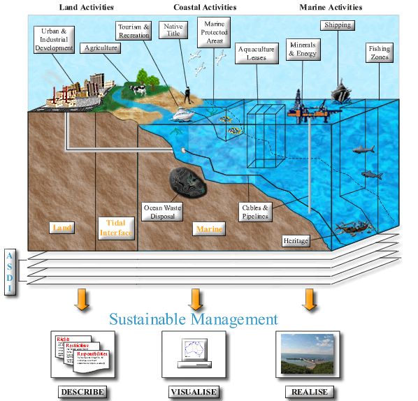
process, a concept diagram was developed, in order to visualise the various aspects of an Australian marine cadastre (Figure 3).
Figure 3 – Marine Cadastre Concept Diagram
The marine concept diagram differs somewhat to other such diagrams developed throughout the world, as it contains areas of
the terrestrial environment, as well as the ocean. The aim of this is to demonstrate that the marine cadastre should not be
-8-developed in isolation from the terrestrial environment. As mentioned earlier, the majority of maritime activity occurs in and
around the coastal zone. This area straddles both land and sea and is the public access point to the marine environment. Urban
and industrial development and other land based activities are also a source of pollution in the marine environment. The
linking of the marine and terrestrial cadastres will enable a more seamless integration of spatial data at the land-sea interface.
The development of a marine cadastre will also aid in integrating local, state and federal government interests, facilitating the
implementation of more integrated and effective coastal zone management techniques.
The diagram also shows the range of stakeholders and activities that occur within Australia’s oceans. Table 3 summarises the
diversity of interests ranging from tourism and recreational activities such as diving and swimming to the disposal of waste
such as jarosite and chemical dumps.
Activity Includes: Activity Includes:
Tourism & Recreation Diving Aquaculture Leases Mussle Farms
Boating Abalone Farms
Fishing Spat Gathering Areas
Swimming Oyster Farms
Marine Protected Areas Marine National Parks Minerals and Energy Mineral Exploration
Marine Sanctuaries Oil and Gas Exploration
Shipping Commercial Shipping Resource Extration
Freight Haulage Native Title Non-exclusive access to
Passenger Ferries the sea and sea-bed.
Heritage Shipwrecks Ocean W aste Disposal Ammunition Dumps
Indigenous Artifacts Chemical Dumps
Cables and Pipelines Oil and Gas pipelines Jarosite Dumps
Telecommunications Scuttled Vessels
Electricity Cables Land-based sources
Table 3 – Range of Activities and Interests in Australia’s Marine Environment
It is not the actual activities which the marine cadastre must take into account however, but the administrative and legal
boundaries which govern where and when such activities can occur. The rights, restrictions and responsibilities that go along
with such boundaries must also be recorded. For example, marine protected areas have defined boundaries for the purpose of
excluding or restricting the rights of marine stakeholders within such an area. Knowledge of the rights and restrictions needs
to be attached to the boundaries, in order for them to be effective. In essence, the marine cadastre would provide the means for
delineating, managing and administering such legally definable offshore boundaries.
The ability to visualise the concept of a marine cadastre also
aids in showing the three dimensional nature of legally defined
boundaries. Aquaculture leases, fishing zones and marine
protected areas are a prime example of boundaries in which
depth, as well as sea surface topology is needed, in order to
sustain effective management.
Another factor which a marine cadastre needs to address is that
the wide range of interests shown in Figure 3 are currently
managed by a number of organizations and agencies within
‘solos’, with each responsible for the collection, collation and
updating of spatial data relating to their own particular interests.
This data needs to be available to all stakeholders in the marine
environment at its most accurate and up-to-date. For this to be
achieved, the ASDI must be in place in the marine environment
to underpin and facilitate the availability and reliability of
spatial data. This would also provide the basis for the
integration of the marine and terrestrial environments, helping
to facilitate sustainable management objectives across
Australia’s entire jurisdiction (Figure 4).
Figure 4 – Integration of the terrestrial & marine
environments through the utilisation of the ASDI The tangible outcome of the marine cadastre concept, as
described by (Todd, 2001) is the ability for users and
stakeholders to “describe, visualise and realise” spatial
information in the marine environment. The marine cadastre will describe the location and spatial extent of rights, restrictions
and responsibilities in the marine environment, including management boundaries, coastal planning guidelines, ocean parcels
and legal definition. Such spatial extents should then be able to be visualised through the continual updating of accurate digital
spatial data through the use of a maintenance environment, and includes the three dimensional nature of the marine
environment together with the advent of time over this space. This ability to describe and visualize maritime boundaries will
enable users to realise them ‘on the ground’. This aids in managing and creating new fisheries or aquaculture leases, policing
-9-marine protected areas, exploration, and the laying of cables and pipelines, enabling an integrated and practical approach to the
management of Australia’s maritime extent.
6. Future Direction and Conclusion
The need for a marine cadastre is increasing, being driven mainly by the need to address the environmental, social and
economic issues of sustainable development. The concept proposed within this paper aims to deal with a range of legal,
institutional and technical issues identified as barriers to the efficient management of legally defined boundaries, within an
Australian context.
It is important to understand the link between the terrestrial and marine environments and recognise that they should not be
treated as separate entities. The cadastre and ASDI enable the efficient management of spatial boundaries in the terrestrial
environment and are tools that should be utilised in the development of a marine cadastre. The underlying principles that
facilitate such management need to be identified and applied in the creation of a marine cadastre. This is especially so in terms
of the ASDI, as it will be the underlying framework for the distribution of spatial data in the marine environment. The marine
cadastre would also link local, state and federal government interests within the marine environment, enabling efficient
management across Australia’s entire jurisdiction.
The marine cadastre concept diagram presents the view of a marine cadastre as a spatial boundary management tool, which
describes, visualizes and realizes the rights, restrictions and responsibilities of maritime stakeholders. The task now is to
attempt to develop the tools and principles that will facilitate the implementation of such a marine cadastre.
Acknowledgements
The authors wish to greatly acknowledge the support of the University of Melbourne, Land Victoria, Geoscience Australia,
Department of Natural Resources and Mines Queensland, the Australian Research Council (ARC) and members of the Marine
Cadastre Research Group and Centre for SDIs and Land Administration at the Department of Geomatics, University of
Melbourne in the preparation of this paper and associated research. The views expressed in this paper are those of the authors
and do not necessarily reflect the views of these groups.
References
AFMA (2000) Environmental Management, Australian Fisheries Management Authority Homepage.
15 September 2002.
AUSLIG (1999) Maritime Zones, Maritime Zones. 25
April 2002.
AUSLIG (2001) Australian Maritime Boundary Information System Data User Guide, AMBIS.
22 Oct 2001.
Barry, M., Elema, I. and Molen, P. V. D. (2003) 'Ocean Governance in the Netherlands North Sea', FIG Working Week 2003,
Paris, France. 24 August 2003.
Collier, P. A., Leahy, F. J. and Williamson, I. P. (2001) 'Defining and Developing a Marine Cadastre for Australia', A Spatial
Odyssey: 42nd Australian Surveyors Congress, Brisbane, Australia.
14 July 2003.
Dalrymple, K., Williamson, I. and Wallace, J. (2003) Cadastral Systems within Australia, The Australian Surveyor, 48 (1) 37-
49.
Finney, K. (2002), Australian Maritime Legislation Review, An internal report compiled for National Ocean Office and
department of Natural Resources and Mines, Queensland.
Fowler, C. and Treml, E. (2001) Building a Marine Cadastral Information System for the United States - a Case Study,
International Journal on Computers, Environment & Urban Systems Special Issues: Cadastral Systems, 25 (4-5) 493-
507.
Grant, D. (1999) 'Principles for a Seabed Cadastre', New Zealand Institute of Surveyors Conference & AGM FIG Commission
VII Conference, Bay of Islands, New Zealand.
Kaye, S. B. (1995) Australia's Maritime Boundaries, Wollongong papers on Maritime Policy No. 4, University of
- 10 -Woolongong, Australia.
Neely, R. M., Treml, E., LaVoi, T. and Fowler, C. (1998) Facilitating Integrated Regional Ocean Management Using a Web-
based Geographic Information System., Coastal Services Centre, National Oceanic and Atmospheric Administration.
25 March 2002.
Ng'ang'a, S., Nichols, S., Sutherland, M. and Cockburn, S. (2001), 'Toward a Multidimensional Marine Cadastre in Support of
Good Ocean Governance - New Spatial Information Management Tools and their role in Natural Resource
Management, International Conference on Spatial Information for Sustainable Development, Nairobe, Kenya.
Nichols, S., Monahan, D. and Sutherland, M. (2000) Good Governance of Canada's Offshore and Coastal zone: Towards an
Understanding of the Marine Boundary Issues, Geomatica, 54 (4) 415-424.
NOAA (1998a), Ocean Planning Information System Aim, Ocean Planning Information System Homepage.
16 March 2002.
NOO (2002a) Ocean Management - The Legal Framework, National Oceans Office, Hobart, Australia.
NOO (2002b) Resources - Using the Ocean, National Oceans Office, Hobart.
PANOS (1995) The World Fisheries Crisis, Development and Cooperation.
Rajabifard, A. (2002) Diffusion of Regional Spatial Data Infrastructures: with particular reference to Asia and the Pacific.,
PhD, Department of Geomatics, University of Melbourne, Melbourne.
10 June 2003.
Rajabifard, A., Collier, P. and Williamson, I. (2003) Report on Australian Marine Cadastre Research and Activities,
University of New Brunswick - FIG Meeting, Fredericton, Canada.
27 October 2003.
Rajabifard, A., Escobar, F. and Williamson, I. (2000) Hierarchical Spatial Reasoning Applied to Spatial Data Infrastrucutres,
Cartography Journal, 29 (2) 41-50.
Reynolds, H. (2000) Indigenous Rights, Community Aid Abroad, 15 October 2002.
Robertson, B., Benwell, G. and Hoogsteden, C. (1999) 'The Marine Resource: Administration Infrastructure Requirements',
UN-FIG Conference on Land Tenure and Cadastral Infrastructures for Sustainable Development, Melbourne,
Australia. 18 July 2003.
Robertson, D. (2002) 'Australia's Maritime Boundaries', Marine Cadastre Workshop, Melbourne, Australia.
15 June 2003.
Robertson, M. (2002) Crocker Islands, Community Aid Abroad. 15th October 2002.
Robinson, C. and Mercer, D. (2000) Reconciliation in troubled waters? Australian oceans policy and offshore native title
rights, Marine Policy, 24 349-360.
Rothwell, D. R. and Haward, M. (1996) Federal and international perspectives on Australia's maritime claims, Marine Policy,
20 (1) 29-46.
Sutherland, M. (2003) Report on the Outcomes of the UNB-FIG Meeting on Marine Cadastre Issues, Wu Centre, University of
New Brunswick, Fredericton, Canada.
27 October 2003.
Todd, P. (2001) 'Marine Cadastre - Opportunities and Implications for Queensland', A Spatial Odyssey: 42nd Australian
Surveyors Congress, Brisbane, Australia.
United Nations (1997), The Law of the Sea: United Nations Convention on the Law of the Sea,
Publication No. E97. Vol.10, United Nations, New York.
UN (2003) Oceans and the Law of the Sea, Oceans and the Law of the Sea. , 14 June
2003.
- 11 -UNB-FIG (2003) Meeting on Marine Cadastre Issues, Wu Centre, University of New Brunswick, Fredericton, Canada.
27 October 2003.
Warnest, M., Feeney, M.-E., Rajabifard, A. and Williamson, I. P. (2002) Fundamental Partnerships Driving Spatial Data
Infrastructure Development Within Australia, Cartography Journal.
17 September 2003.
Widodo, S. (2003) 'The Needs for Marine Cadastre and Supports of Spatial Data Infrastructures in Marine Environment - A
Case Study', FIG Working Week, Paris, France. 24 August
2003.
- 12 -You can also read