Accessibility of Public Urban Green Spaces within the Spatial Metropolitan Network of Doha, State of Qatar - ISOCARP
←
→
Page content transcription
If your browser does not render page correctly, please read the page content below
Tannous, H.O.; Major, M.D., Furlan, R.                   Accessibility of Public Urban Green Spaces within
                                                         the Spatial Metropolitan Network of Doha, State
                                                         of Qatar.

                                               Research Paper

Accessibility of Public Urban Green Spaces within the
  Spatial Metropolitan Network of Doha, State of
                         Qatar
                              Heba O. TANNOUS, Research Associate, Qatar
           Mark David MAJOR, Assistant Professor of Architecture and Urban Design, Qatar
            Raffaello FURLAN, Assistant Professor of Architecture and Urban Design, Qatar

     Abstract
     Most people regard green spaces as a necessity to enhance the physical health and psychological
     well-being of residents in promoting the general health and welfare of citizens and the
     environment (Röbbel, 2016). In the Modern Era, the availability of green spaces has become an
     integral component of urban planning for sustaining the quality of life in city environments,
     especially since the dawn of the 20th century. Due to globalization in rapidly-developing cities
     around the world, studies about green spaces are becoming an increasingly important part of the
     urban planning process (Mitchell and Popham, 2007). Accessibility can play an essential role in
     determining the location of green public facilities to maximize their usability for large
     populations, or otherwise limit use to a smaller community (Ottensmann and Greg, 2008).
     However, some public green spaces are inefficiently located or distributed in urban environments
     (Beatley, 2000, Gehl, 2010, Gehl and Svarre, 2013). In this paper, the accessibility of urban green
     spaces means the ease of reaching such locations from many origins within the urban spatial
     network from the macro- to the micro-scale. The inaccessibility or absence of green spaces in
     some urban areas is a notable consequence of rapid urbanization in many cities around the
     world. It is especially noticeable in the capital city of Doha in the State of Qatar, where rapid
     urban expansion and globalization has had a significant impact on the quality and quantity of
     green spaces available (Salama and Wiedmann, 2013a). The paper utilizes the network analysis
     techniques of space syntax to objectively investigate the accessibility of urban green parks and
     promenades in the metropolitan region of Doha (Penn et al., 1998, Hillier et al., 1993, Hillier and
     Hanson, 1984). At the heart of the paper is the question, does the size and location of urban
     green spaces follow a discernible spatial logic in terms of accessibility, linked to the design intent
     of public planning policies? Some findings in the paper indicate there is distinctive spatial and
     social logic to the physical and spatial characteristics of urban green spaces above a certain size
     in terms of metric area. In contrast, these characteristics in smaller urban green spaces tend to
     be more random, primarily due to issues of land availability and amenity provision in private
     developments. We conclude by discussing the potential implications of the study for public
     planning policy about green urbanism in the State of Qatar and other rapidly urbanizing cities
     around the world.

     Keywords
     Accessibility, Green Spaces, Network Science, Planning Policy, Urban

                                                                 56th ISOCARP World Planning Congress in Doha, Qatar
                                                                      International Society of City and Regional Planners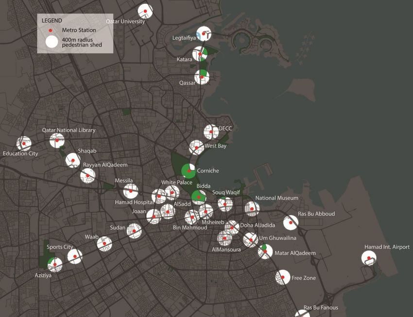
Tannous, H.O.; Major, M.D., Furlan, R.                 Accessibility of Public Urban Green Spaces within
                                                        the Spatial Metropolitan Network of Doha, State
                                                        of Qatar.

    1. Introduction
Many of the major cities in the developing world share common problems arising from rapid
development and population growth. It is a result of changes in land use to cater to the growing need for
industrial, commercial, and residential development. Such growth is further intensified in the case of the
capital city of Doha in the State of Qatar, driven by rapid economic development during the last two
decades. There are significant government efforts to transform Doha physically and economically from its
fishing and pearling village origins of the early 20th century into a modern diversified economy with global
aspirations in the 21st century. The population of Qatar is over 2.8 million inhabitants in 2020 with a
projected increase of 1 million within the next 20 years based on the most recent United Nations data.
Over half of the population is concentrated in Metropolitan Doha (Ministry of Development Planning and
Statistics, 2020).
Although the natural gas and petroleum resources are immense, the government is aiming economic
diversification plans at the tourism, education, sports, and other service-related industries (Dumper and
Stanley, 2007). Doha is currently constructing several mega-projects, stadiums, and the associated
facilities necessary for hosting the FIFA World Cup in 2022. Other projects include the Qatar Rail
metropolitan public rail transit system, Lusail City masterplan, Hamad Port, Green Parks, and expanded
road infrastructure network (Figure 1). With many of these projects along the coastline, large sections
have been artificially modified involving reclaimed land as the original shoreline was located further
inland (Figure 2a).

                                                  (a)                                                         (b)

Figure 1. Maps of Doha highlighting (a) satellite cities, mega-projects, and FIFA 2022 Stadium, and (b) Qatar
Rail main metro lines and stations. (Source: Authors/Qatar Rail).

Driven by this rapid growth, Qatar has one of the fastest-growing populations in the Arab world with the
population increasing by approximately 30% between 2003 and 2012 (Tannous, 2020) (Figure 2b). The
majority of this population (~90%) live in the capital city of Doha. Under these circumstances, the

                                                               56th ISOCARP World Planning Congress in Doha, Qatar
                                                                    International Society of City and Regional Planners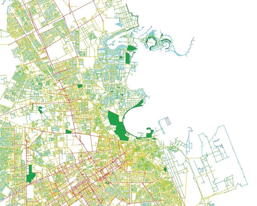
Tannous, H.O.; Major, M.D., Furlan, R.               Accessibility of Public Urban Green Spaces within
                                                      the Spatial Metropolitan Network of Doha, State
                                                      of Qatar.

provision of green spaces does not become a high priority compared to other necessities such as housing,
industrial, and infrastructure (Hashem, 2015, Tan et al., 2013). The overall urban planning strategy of
simultaneous densification and land consumption is a major contributory factor for environmental
deterioration in the country (Salama and Wiedmann, 2013a).

                                 (a)                                                                     (b)

Figure 2. (a) Changes in Doha's shoreline through 1984-2016; (b) Urban Land in Doha between 2003 through
2012 (Source: Authors/(Salama and Wiedmann, 2013b).

The State of Qatar government developed the Qatar National Vision 2030 (QNV) to address the lack of a
national planning framework. It aims to guide the development strategies across all sectors of the
country. In the light of the QNV, the Ministry of Municipality and Urban Planning (MMUP) and Ministry
and Municipality of Environment (MME) has adopted a national framework for urban development with
a master plan under the Qatar National Development Framework (QNDF) (Ministry of Municipality &
Environment, 2016a). One of the main principles for guiding development is the appropriation of urban
design and planning strategies to ensure sustainable growth and preservation of land for public green
spaces (Figure 3).
In the case of Doha, green spaces are very resource-demanding due to the dry and hot desert climate.
Due to the extreme heat and lack of rain, most irrigation water comes from desalination plants that are
expensive to run (Hashem, 2015). These public green spaces also require high investment in labor forces
for maintenance and sophisticated irrigation systems used in cities within a desert climate. Given these
issues, the Public Parks Department of the MME has successfully implemented a field experiment
intending to minimize water used in irrigation. This is an initiative to help increase the green areas in
different parts of the country (Ministry of Municipality & Environment, 2016b).

                                                            56th ISOCARP World Planning Congress in Doha, Qatar
                                                                 International Society of City and Regional Planners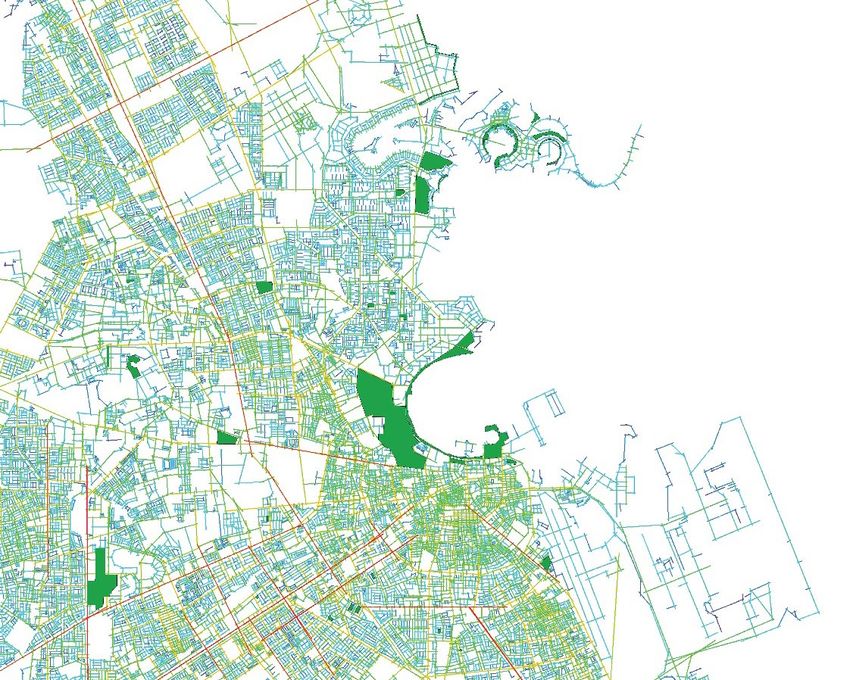
Tannous, H.O.; Major, M.D., Furlan, R.                  Accessibility of Public Urban Green Spaces within
                                                         the Spatial Metropolitan Network of Doha, State
                                                         of Qatar.

Figure 3. Key components of Qatar National Vision 2030 (Source: (General Secretariat for Development
Planning, 2008).

Green Urbanism
Green Urbanism is interdisciplinary by definition. It involves collaboration between the fields of
landscape, architecture, engineering, urban planning, transport planning, ecology, psychology, sociology,
economy, and many other specialists. Green Urbanism is an approach that adopts different disciplinary
perspectives in promoting sustainability as its primary objective. It highlights the role of cities in reducing
greenhouse gas emissions based on fossil fuels and the preservation of the natural systems of the
environment. The principles of Green Urbanism form the basis for a conceptual framework, which allows
for the development and transformation of existing neighborhoods and communities in cities. It offers a
way to re-think about the way we design and build our future urban settlements. A key goal of Green
Urbanism involves retrofitting existing built environments to operate within ecological limits through the
promotion of compact development utilizing different modes of transportation (Beatley, 2000). We can
summarize the principles of Green Urbanism into four categories: urban planning and transport, energy
and materials, socio-cultural features, and water and biodiversity (Lehmann, 2014). Lehman offers
perhaps the best outline of these general principles for Green Urbanism and their inter-relationship
(Figure 4).

Figure 4. 15 principles and their inter-relationship in Green Urbanism (Lehmann, 2014).

Urban Green Spaces
Public green spaces are a component of ‘green infrastructure,’ which provides for many social, physical,
and environmental benefits including urban heat reduction (Anguluri and Narayanan, 2017). They can
serve as recreational areas for residences and enhance the environmental quality of neighborhoods. The

                                                                56th ISOCARP World Planning Congress in Doha, Qatar
                                                                     International Society of City and Regional Planners
Tannous, H.O.; Major, M.D., Furlan, R.                Accessibility of Public Urban Green Spaces within
                                                       the Spatial Metropolitan Network of Doha, State
                                                       of Qatar.

availability and accessibility of green spaces are a significant contributor for human well-being in urban
cities (Amano and Butt, 2018). With a set of a range of policies on urban green spaces, the European
Environment Agency recommends that citizens should have access to green spaces within 15 minutes
walking distance, i.e., approximately 2 km (Stanners and Bourdeau, 1995). Other studies in planning and
environmental disciplines highlight the social and ecological benefits of urban green space depending on
their size and accessibility (Box and Harrison, 1993, Harrison et al., 1995). In addition to user needs and
the quality of green spaces, there is a large body of research focusing on the role of the built environment
on human behavior in public open spaces over the last half-century (Jacobs, 1961, Whyte, 1980, Hillier,
1996b, Gehl, 2010, Campos, 1999, Gehl, 2011). Many argue additional benefits like improving air quality,
general health and well-being of the citizens, and enhancing the urban setting of cities (Lee et al., 2015,
Mitchell and Popham, 2007). Therefore, just like any other land use, the way these green spaces are
located and distributed is essential. Selecting inappropriate locations for public green spaces can make
them less accessible to the public, leading to underutilized or sometimes neglected spaces. At worst,
these spaces become abused or exploited for illicit and criminal behaviors (Hillier, 1996a).
The smart allocation of easily accessible and equally-distributed green spaces can serve as a health-
promoting setting for all members of the urban community. Sustainable and accessible public green
spaces are necessary to provide a higher quality of life in cities. Public green spaces are generally any
outdoor space providing green vegetation for active or passive uses accessible to the general public. Such
areas include formal parks, community gardens, informal green spaces/landscapes, playgrounds, and
plazas but not spaces that can be characterized as exclusively landscape medians for only visual
appearance, i.e., curb appeal.

Accessibility of Urban Green Spaces
Most studies about the accessibility of urban green spaces are based on metric distance. However,
topological distance in space syntax terms is also a potentially important, often overlooked factor for the
location of public green spaces (Koohsari et al., 2014). Instead of mere location based only on metric
distance, understanding and quantifying the distribution and accessibility of public green spaces based on
the configurational measurements of space syntax using axial analysis might prove fruitful for promoting
the physical and social functioning of public green spaces in a city.
This research paper aims to examine the accessibility of public urban green spaces relative to metric size
in the area of Metropolitan Doha, Qatar. The research draws on a previous study by the authors
examining the accessibility of public green spaces in Doha in the year 2013 (Tannous et al., Forthcoming).
Subsequently, this study identifies and incorporates four (4) parks and three (3) promenades that were
not previously listed by the MME as public amenities at the time of the previous research study (Figure
5a). The classification of these different types of public green spaces in this research study relies on the
metric area and service radius. It is divided into seven (7) types: mini-neighborhood, neighborhood, local,
community, regional, metropolitan/national, and promenades. Promenades are the only classification
not based on metric area but due to their location adjacent to the coastline of the Arabian/Persian Gulf
(Figure 5b). In addition to these promenades, there are also many parks located in the vicinity of the
coast due to the importance of the Arabian/Persian Gulf for the city of Doha. However, the quantity of
green space is not necessarily the defining characteristic of promenades as public amenities. Sports fields
such as football pitches serving as support facilities for World Cup 2022 are not included in this analysis,
especially if the MME does not list them as official parks.
The research reviews the current availability and accessibility of thirty-three (33) public parks and
promenades based on high-resolution aerial photos from 2013-2019, supplemented by the use of an

                                                              56th ISOCARP World Planning Congress in Doha, Qatar
                                                                   International Society of City and Regional Planners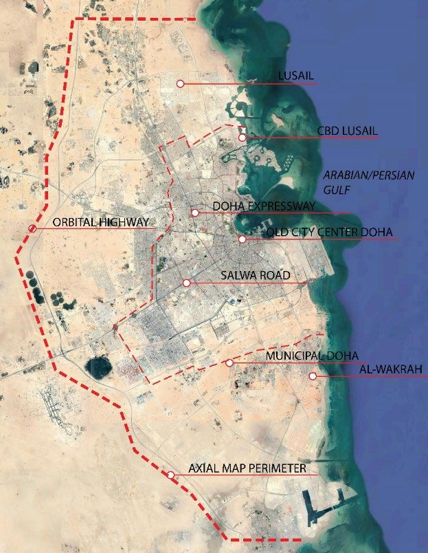
Tannous, H.O.; Major, M.D., Furlan, R.                     Accessibility of Public Urban Green Spaces within
                                                            the Spatial Metropolitan Network of Doha, State
                                                            of Qatar.

MME index listing official parks in the city of Doha. This study continues and expands on the analysis of
these public green spaces in the urban spatial network of Metropolitan Doha used in the earlier study
(Tannous et al., Forthcoming). The underlying basis for quantifying the accessibility of public green spaces
using space syntax is the theory of natural movement. This theory states that movement patterns in cities
arise naturally from the way the street network organizes the simplest routes to and from all locations
involving the fewest changes of direction in the network before accounting for the location of attractors
or generators of that movement such as specific land uses (Hillier et al., 1993, Penn et al., 1998). Based
on the analysis and findings of this study, the paper argues for the existence of a spatial and social logic to
the public green spaces of Metropolitan Doha, especially above a certain size. The paper concludes with
some suggestions for the future planning and expansion of some public green spaces in Metropolitan
Doha.

Figure 5. (a) The studied public parks and promenades on the map of Metropolitan Doha; b) promenades
and parks running parallel to the coastline of Doha (Source: Authors).

Space syntax
Space syntax has been used in a wide range of research projects to explain human behaviors and predict
patterns of movement from the point of view of spatial configuration (Hillier, 1996a). Some of this
research examined the morphological structure of buildings (Peponis et al., 1990), sociocultural
implications of different plans (Hanson, 1989), urban renewal (Miller, 1989), predictions of spatial
patterns of crime in urban areas (Hillier et al., 1989), and, frequently, movement patterns in urban
settings (Hillier and Hanson, 1984, Hillier et al., 1983, Hillier et al., 1987, Hillier et al., 1989, Peponis et al.,
1989). Space syntax researchers have also found significant correlations between spatial configuration
and empirical observations of pedestrian and vehicular movement levels (Hillier, 1996b, Hillier et al.,
1993, Penn et al., 1998). Major development projects around the world extensively applied space syntax
as a design and planning tool over the last thirty years (Major, 2018). In its simplest formation, space
syntax allows us to better identify and understand human behavior in the urban environment in terms of
movement, occupation, and use.
There are many previous research-based studies of urban green spaces based on statistical evaluation of
demographics and design characteristics, location-based attraction modeling, or user surveys to
understand some attributes of accessibility (Ottensmann and Greg, 2008, Strauss and Miranda-Moreno,
2013, Sahebgharani et al., 2019). Other studies focus on localized issues such as human thermal comfort
(Indraganti and Boussaa, 2018), quality and status of green parks, or the impact of road network
expansion on the urban landscape (Wenbo et al., 2017). However, there is a lack of quantitative research

                                                                   56th ISOCARP World Planning Congress in Doha, Qatar
                                                                        International Society of City and Regional Planners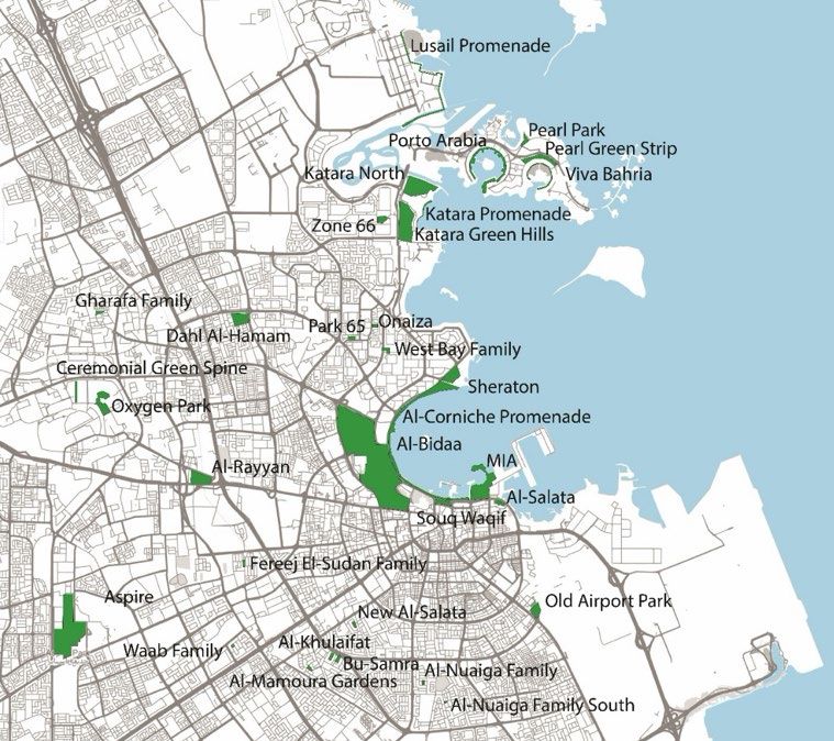
Tannous, H.O.; Major, M.D., Furlan, R. Accessibility of Public Urban Green Spaces within
the Spatial Metropolitan Network of Doha, State
of Qatar.
on the subject in the GCC region. The study utilizes space syntax for the quantitative measurements of
accessibility within the urban spatial network. It uses a distance concept (relativized mean depth)
measured in steps or changes of direction called topological distance (Hillier and Hanson, 1984). Space
syntax models the spatial configurations of the urban space by using a connectivity graph representation.
It highlights the most accessible (or integrated) spaces which tend to obtain higher levels of movement
and activities, and the less accessible (or segregated) spaces tend to experience less use most of the time.
The term accessibility has a broad meaning in both green urbanism and space syntax. In this research
study, accessibility refers to different ranges of integration from across the urban spatial network of
Metropolitan Doha to the perimeter streets providing access points to the public green spaces selected
for the study. In this sense, accessibility is an essential factor for consideration to provide a strategic plan
for public green spaces within their broader neighborhood, regional, and metropolitan network.
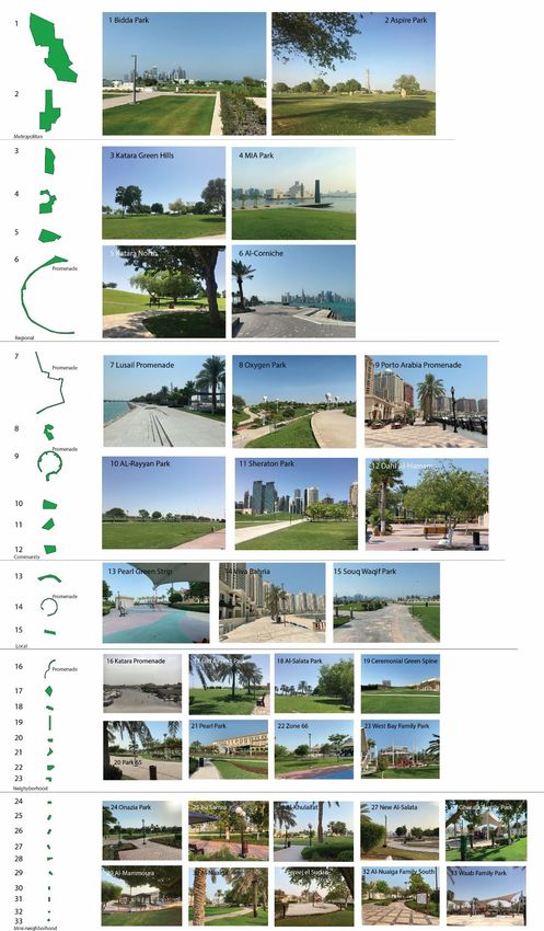
However, in this most recent version of the study, we begin to layer metric distance into the analysis
based on the drawing of pedestrian sheds within a radii of 400 m from recently-opened Doha Metro
stations in relation to the case study parks, green spaces, and promenades.
Measurements and Techniques
Configurational measures offer a scientific basis to implicate or dismiss the designed spatial network as a
factor in social, functional, and/or cultural outputs. Space syntax software also incorporates metric
parameters such as the length of streets/street segments and the plan area/perimeter surface area of
visual fields. Over four decades, researchers have developed a diverse number of configurational and
metric measures using space syntax. Some are more useful than others, and sometimes it can take years
of testing to confirm or refute their usefulness. It can be overwhelming for those unfamiliar with space
syntax. Generally, the most useful are:
Connectivity is a simple measure of how many other spaces does a single space immediately connect to
within the network.
Integration is the relativized mean depth of a space in relation to all other spaces in a network based on
changes of direction using connectivity (see above). It represents how integrated/shallow or
segregated/deep is a space within a spatial network. It demonstrates the pattern of 'to-movement' for
those spaces most likely used for journeys from anywhere to everywhere else in the spatial network.
Researchers can set the radii of integration measures based on specified parameters such as global
integration (radius=n) and local integration (radius=3).
Local integration is relativized mean depth of a space in relation to all other spaces in a network based on
three changes of direction, which highlights the more immediate catchment area of a single space within
the network. In effect, the justified topological graph underlying the measure is 'cut' off for every space
more than three changes of anywhere from the origin space. Most usually, local integration is strongly
related to connectivity (see above) because they measure the more immediate characteristics of space in
the network. In the real world, the simplest way to understand local integration is if a person imagines
themselves standing in the middle of an intersection of two or more spaces, looks down both spaces in all
directions to see all other spaces immediately connected to those spaces defining the intersection, and
then repeated that process for all the other intersections they can see from the first intersection. In
larger spatial systems such as cities, it is often useful to limit the radius of integration based on relativized
mean depth from the most globally integrated space in the spatial network because it reduces, though
not necessarily eliminates completely, 'edge effect,' i.e., spaces at the edges of the spatial network tend
towards segregation merely because of their location at the edge.
56th ISOCARP World Planning Congress in Doha, Qatar
International Society of City and Regional Planners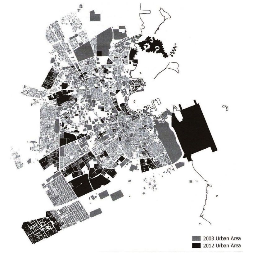
Tannous, H.O.; Major, M.D., Furlan, R.                   Accessibility of Public Urban Green Spaces within
                                                          the Spatial Metropolitan Network of Doha, State
                                                          of Qatar.

Finally, researchers can also set the radii of various configurational measurements based on metric
parameters using the average distance to the center of each segment as defined by the midpoint
between two separate connections such as 500 meters (m), 1000m, or 5000m. Despite incorporating
metric measures, researchers consistently find that the correlation with configurational measures tends
to be more significant for understanding the 'social logic of space' than metric ones (Hillier and Vaughan,
2007).

Research methodology
The main research study methodology consists of two main phases:
Identifies and locates official public parks and promenades in mapping for the case studies of the
research study.
Obtains and analyzes the quantitative measurements of different levels of integration relative to the
metric area of all perimeter streets providing points of access to the studied public green spaces to all
other axial lines in the urban spatial network of Metropolitan Doha. We utilize three parameters of
integration, i.e., global (radius=n), local (radius=3), and mean depth based on the most integrated streets
in Doha (radius=8).

Table 1. Classification and categories of the studied parks and promenades according to their metric areas
and service radius.
                           Type              Amount   Area                Service Radius
                 Mini-neighborhood (MN)        10       150
                                                              as an urban setting on a national basis
                 Promenade (P)                 5              No specified area
                 TOTAL                         33

The research study focuses on the metropolitan region of Doha, Qatar. We classify and organize the case
study parks and promenades according to metric area and size parameters into the following categories
(Table 1 and Figure 6):
    •   Mini-neighborhoods (N) below 4 acres in size with a service radius of approximately ¼ miles.
    •   Neighborhood (N) ranging in size between 4-10 acres with a service radius of 1 mile.
    •   Local (L) ranging in size between 10-20 acres serving 1-2 miles radius.
    •   Community (C) ranging in size between 20-50 acres with a service radius of 2-5 miles.
    •   Regional (R) ranging in size between 50-150 acres with a service radius of over 5 miles.
    •   Metropolitan/national (M) with the metric area over 150 acres serving the metropolitan region.
    •   Promenades are identified and located due to their location along the coast of Doha.

                                                                  56th ISOCARP World Planning Congress in Doha, Qatar
                                                                       International Society of City and Regional Planners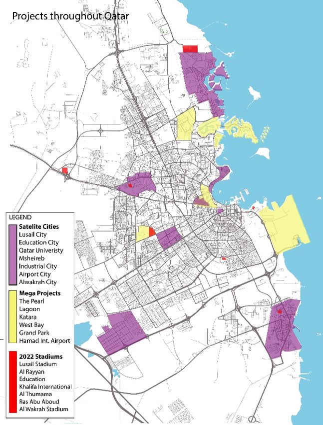
Tannous, H.O.; Major, M.D., Furlan, R.              Accessibility of Public Urban Green Spaces within
                                                     the Spatial Metropolitan Network of Doha, State
                                                     of Qatar.

Figure 6. Case study green spaces in descending order (in terms of metric area) within Metropolitan Doha
(Source: Authors).

                                                            56th ISOCARP World Planning Congress in Doha, Qatar
                                                                 International Society of City and Regional Planners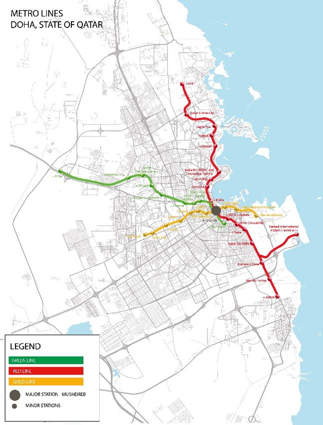
Tannous, H.O.; Major, M.D., Furlan, R.                 Accessibility of Public Urban Green Spaces within
                                                        the Spatial Metropolitan Network of Doha, State
                                                        of Qatar.

The axial map in this study stretches from Lusail in the north to Al-Wakrah to the south and from the
Arabian/Persian Gulf in the east to the Orbital Highway to the west (Figure 7a). Researchers constructed
the 2019 space syntax model of Metropolitan Doha based on a collection of high-resolution satellite
images in 2019, updated against the initial modeling based on a 2013 MME map showing building
footprints at a scale of 1:400 and various satellite images from 2013-2018. The axial map consists of over
24,200 streets covering an area of over 1,000 km2. Researchers located the streets defining the perimeter
of the 33 public parks and promenades of the study in the axial map. The analysis of different degrees of
accessibility was based on the average value of all perimeter streets, as well as relative to the metric area
of the urban green space itself.

Figure 7. The area of study for the axial map referred to as Metropolitan Doha (Source: Authors).

Findings
As explained in the previous section, this research study illustrates the levels of accessibility of 33 public
parks and promenades. The total area of these green spaces is approximately 1,132 acres or about 1 acre
every 1,200 residents in Metropolitan Doha. According to the National Recreation and Parks Association
(NRPA), the typical park level of services is 9.9 acres per 1,000 residents across different parks and
recreation agencies of the United States. It suggests that the current levels of service for public parks and
promenades in Metropolitan Doha are nearly 12 times lower than that found in the USA in general. All
the promenades and many of the parks locate immediately adjacent or relatively near to the
Persian/Arabian Gulf coastline in the city. These green spaces include all the parks and promenades at
The Pearl, Sheraton, Al-Corniche, Al-Bidda, and MIA from north to south of the coastline. Others consist
of smaller parks serving their immediate surrounding neighborhoods, such as the Al-Gharafa, Al-
Khulaifat, and Al-Nuaiga parks.
The spatial structure of the metropolitan region is characterized by the ortho-radial grid based on long
radial routes (e.g., Salwa Road to the southwest, and Al Rayyan Road to the west) from the old city center

                                                               56th ISOCARP World Planning Congress in Doha, Qatar
                                                                    International Society of City and Regional Planners
Tannous, H.O.; Major, M.D., Furlan, R. Accessibility of Public Urban Green Spaces within
the Spatial Metropolitan Network of Doha, State
of Qatar.
of Doha near the coastline and a successive series of ring roads (A-G) radiating outward from Doha Bay to
the metropolitan edges and the new Orbital Highway (Ring Road G). A few research studies elaborate on
the well-defined spatial logic of Doha at the macro- and micro-scale of its metropolitan region using
space syntax (Tannous, 2020, Tannous and Major, 2020, Mirincheva, 2015). An aim of this research study
is establishing the spatial parameters of the green parks and promenades by locating them in the space
syntax model of Metropolitan Doha based on their streets defining their perimeter based on an average
of each accessibility measure. It provides a common representative measurement for each park and
promenade within its local and larger metropolitan context (Table 2 and Figure 7).
Table 2. The public parks, promenades, and green spaces from largest to smallest for metric area showing
(from left to right): name of the green space, type classification, region within the city, area in acres and m2,
and the average global integration (Rn), local integration (R3), and integration based on mean depth from
most integrated street (R8).
Local
Global Integration
Park Name Type Region Area Acre Area m2 Integration
rad=n rad=8
rad=3
1 Bidda M East 426.0 1,723,962 1.282 2.578 1.668
2 Asipire M South West 185.7 751,502 1.496 3.256 2.007
3 Katara Green Hills R East 74.3 300,682 0.972 2.199 1.433
4 MIA R East 70.5 285,304 0.939 1.973 1.223
5 Katara North R North 65.4 264,665 0.877 1.807 1.247
6 Al-Corniche P East 57.2 231,480 1.114 2.179 1.480
7 Lusaail P North 33.5 135,570 0.976 1.714 1.231
8 Oxygen C West 31.3 126,667 0.989 1.500 1.115
9 Porto Arabia P North 28.0 113,312 0.552 1.083 0.826
10 Al-Rayyan C West 24.2 97,934 1.488 2.941 1.877
11 Sheraton C East 22.9 92,673 0.990 2.292 1.413
12 Dahl Al-Hamam C North 21.6 87,412 1.275 2.978 1.802
13 Pearl Green Strip L North 19.3 78,104 0.605 1.599 1.006
14 Viva Bahria P North 10.9 44,111 0.552 1.083 0.826
15 Souq Waqif L East 10.1 40,873 1.259 3.087 1.704
16 Katara Promenade P East 8.2 33,265 0.758 1.389 0.959
17 Old Airport Park N South 6.8 27,519 1.202 3.105 1.787
18 Al-Salata N South East 6.2 25,091 1.106 2.895 1.577
19 Ceremonial Green Spine N West 5.9 23,876 1.467 2.847 1.599
20 Park 65 N North 5.5 22,258 1.019 2.238 1.487
21 Pearl Park N North 5.1 20,639 0.647 1.776 1.090
22 Zone 66 N North 4.2 16,997 0.924 2.216 1.345
23 West Bay Family Park N North 4.0 16,187 1.071 2.339 1.532
24 Onaiza Park MN North 2.4 9,712 0.846 1.200 1.175
25 Bu Samra MN South 2.4 9,712 1.522 2.624 1.951
26 Al-Khulaifat MN South 2.3 9,308 1.100 0.887 1.294
27 New Al Salata MN South 1.8 7,284 1.115 1.295 1.409
28 Gharafa Family MN North West 1.7 6,880 1.032 2.491 1.389
29 Al-Mamoura Garden MN South 1.7 6,880 1.272 2.100 1.685
30 Al-Nuaiga family MN South 1.0 4,047 1.028 1.489 1.370
31 Fereej Al Sudan Family MN South 1.0 4,047 1.389 2.603 1.845
32 Al-Nuaiga family (South) MN South 0.9 3,642 1.139 2.503 1.629
33 Waab Park MN South 0.8 3,076 1.184 1.484 1.595
TOTAL 1142.8 4,621,595
AVERAGE 34.6 144,425 1.066 2.114 1.442
* Because of its size, Katara Promenade falls within the neighborhood range, but there are beach extensions and under-construction continuation of the
promenade.
56th ISOCARP World Planning Congress in Doha, Qatar
International Society of City and Regional PlannersTannous, H.O.; Major, M.D., Furlan, R. Accessibility of Public Urban Green Spaces within
the Spatial Metropolitan Network of Doha, State
of Qatar.
(a)
(b)
56th ISOCARP World Planning Congress in Doha, Qatar
International Society of City and Regional PlannersTannous, H.O.; Major, M.D., Furlan, R. Accessibility of Public Urban Green Spaces within
the Spatial Metropolitan Network of Doha, State
of Qatar.
(c)
Figure 8. Space syntax model of the urban spatial network Metropolitan Doha showing the pattern of
accessibility of the studies green spaces for (a) global integration, (b) local integration, and (c) integration
(radius=8).
The global integration core, as previously identified in the earlier research, has shifted southwest to the
D-ring Doha Expressway and the intersection between Al-Waab Road and Al-Rayyan Road. With the
majority of the regional and metropolitan parks located along the coast, they are relatively locally
segregated. Aspire Park is one of the few major parks that have strong local integration along the western
edge. When different levels of accessibility measures are relativized for the metric area for these urban
green spaces, interesting distinctions start to emerge in the data. Since 2013, there are a few important
streets that have opened like the Orbital Highway and Sabah Al-Ahmad Corridor along with the south
district in Lusail City. With these new roads and the additional parks and promenades, updating the space
syntax model, recalculating the accessibility measures, and the ratio to size, the results appear largely
consistent between 2013 and 2019. This is mainly due to two reasons. There is only a 6 year difference
the two studies. Although Doha is rapidly developing, this amount of time is not enough to have a
considerable difference with regards to the urban spatial network at the metropolitan scale. It also points
to the robustness of the space syntax model as an objective tool to better understand the current
conditions of the urban spatial network and measure the accessibility of these parks within their urban
settings.
We added Al-Waab Park to this study. It is one of the smallest mini-neighborhood parks in the city.
However, it is highly integrated due to its contextual relations located between Salwa Road and Al-Waab
St. which are two of the most integrated streets in the city. Similar to Al-Rayyan Park, our analysis
suggests Al-Waab Parks warrants special due care in its design and planning for any future expansion
because of its strategic location at the local and metropolitan scale of the network. There is land available
to the north and west of the park. However, it is privately owned and currently set aside for residential
land uses.
56th ISOCARP World Planning Congress in Doha, Qatar
International Society of City and Regional PlannersTannous, H.O.; Major, M.D., Furlan, R. Accessibility of Public Urban Green Spaces within
the Spatial Metropolitan Network of Doha, State
of Qatar.
To determine whether there is an underlying spatial logic to the locating of the parks and promenades
regardless of their size, we control for size utilizing a ratio. When accessibility measures are relativized for
the metric area, many interesting distinctions emerge in the data (Table 3). However, the metric area
remains a strong indicator of the distribution, as some variations might simply attributable to land
availability and amenity provisions in private developments.
Some of the previous findings indicate there appears to be a lack of correspondence between
accessibility and metric area in some parks like Al-Rayyan Park and Porto Arabia Promenade (Tannous et
al., Forthcoming). Al-Rayyan Park seems too small for its strong degree of accessibility in the urban spatial
network. On the other hand, Porto Arabia Promenade appears oversized for its degree of accessibility at
the macro- and micro-scale of the urban spatial network. Onaiza Park and West Bay Family Park both
represent the most typical parks in the city as their values hover nearest to the mean for different
measurements of integration. Other parks below 4 acres tend to possess higher values for local
integration, which is unsurprising since they serve specific neighborhoods.
Table 3. The rank order of public parks, promenades, and green spaces set to a ratio based on metric area
for (left) global integration, (center) local integration, and (right) integration (radius-8) where green
indicates the highest (extremely accessible for its size), orange indicates the lowest (very large for its
accessibility) and the thick black line indicates the mean for the sample.
Decending order of Global Rn/Area Decending order of Local Intg R3/Area Decending order of Local Intg R8/Area
Local
Global Global/Area Local Intg. Integration Integration/
Park Name Area Acres Park Name Area Acres Intg./Area Park Name Area Acres
rad=n Acres rad=3 rad=8 Area Acres
Acres
Waab Park 0.8 1.184 1.559 Al-Nuaiga family (South) 0.9 2.503 2.782 Waab Park 0.8 1.595 2.099
Fereej Al Sudan Family 1.0 1.389 1.389 Fereej Al Sudan Family 1.0 2.603 2.603 Fereej Al Sudan Family 1.0 1.845 1.845
Al-Nuaiga family (South) 0.9 1.139 1.266 Waab Park 0.8 1.484 1.952 Al-Nuaiga family (South) 0.9 1.629 1.810
Al-Nuaiga family 1.0 1.028 1.028 Al-Nuaiga family 1.0 1.489 1.489 Al-Nuaiga family 1.0 1.370 1.370
Al-Mamoura Garden 1.7 1.272 0.748 Gharafa Family 1.7 2.491 1.465 Al-Mamoura Garden 1.7 1.685 0.991
Bu Samra 2.4 1.522 0.634 Al-Mamoura Garden 1.7 2.100 1.235 Gharafa Family 1.7 1.389 0.817
New Al Salata 1.8 1.115 0.620 Bu Samra 2.4 2.624 1.093 Bu Samra 2.4 1.951 0.813
Gharafa Family 1.7 1.032 0.607 New Al Salata 1.8 1.295 0.719 New Al Salata 1.8 1.409 0.783
Al-Khulaifat 2.3 1.100 0.478 West Bay Family Park 4.0 2.339 0.585 Al-Khulaifat 2.3 1.294 0.563
Onaiza Park 2.4 0.846 0.353 Zone 66 4.2 2.216 0.528 Onaiza Park 2.4 1.175 0.489
West Bay Family Park 4.0 1.071 0.268 Onaiza Park 2.4 1.200 0.500 West Bay Family Park 4.0 1.532 0.383
Ceremonial Green Spine 5.9 1.467 0.249 Ceremonial Green Spine 5.9 2.847 0.483 Zone 66 4.2 1.345 0.320
Zone 66 4.2 0.924 0.220 Al-Salata 6.2 2.895 0.467 Ceremonial Green Spine 5.9 1.599 0.271
Park 65 5.5 1.019 0.185 Old Airport Park 6.8 3.105 0.457 Park 65 5.5 1.487 0.270
Al-Salata 6.2 1.106 0.178 Park 65 5.5 2.238 0.407 Old Airport Park 6.8 1.787 0.263
Old Airport Park 6.8 1.202 0.177 Al-Khulaifat 2.3 0.887 0.386 Al-Salata 6.2 1.577 0.254
Pearl Park 5.1 0.647 0.127 Pearl Park 5.1 1.776 0.348 Pearl Park 5.1 1.090 0.214
Souq Waqif 10.1 1.259 0.125 Souq Waqif 10.1 3.087 0.306 Souq Waqif 10.1 1.704 0.169
Katara Promenade 8.2 0.758 0.092 Katara Promenade 8.2 1.389 0.169 Katara Promenade 8.2 0.959 0.117
Al-Rayyan 24.2 1.488 0.061 Dahl Al-Hamam 21.6 2.978 0.138 Dahl Al-Hamam 21.6 1.802 0.083
Dahl Al-Hamam 21.6 1.275 0.059 Al-Rayyan 24.2 2.941 0.122 Al-Rayyan 24.2 1.877 0.078
Viva Bahria 10.9 0.552 0.051 Sheraton 22.9 2.292 0.100 Viva Bahria 10.9 0.826 0.076
Sheraton 22.9 0.990 0.043 Viva Bahria 10.9 1.083 0.099 Sheraton 22.9 1.413 0.062
Oxygen 31.3 0.989 0.032 Pearl Green Strip 19.3 1.599 0.083 Pearl Green Strip 19.3 1.006 0.052
Pearl Green Strip 19.3 0.605 0.031 Lusaail 33.5 1.714 0.051 Lusaail 33.5 1.231 0.037
Lusaail 33.5 0.976 0.029 Oxygen 31.3 1.500 0.048 Oxygen 31.3 1.115 0.036
Porto Arabia 28.0 0.552 0.020 Porto Arabia 28.0 1.083 0.039 Porto Arabia 28.0 0.826 0.030
Al-Corniche 57.2 1.114 0.019 Al-Corniche 57.2 2.179 0.038 Al-Corniche 57.2 1.480 0.026
Katara North 65.4 0.877 0.013 Katara Green Hills 74.3 2.199 0.030 Katara Green Hills 74.3 1.433 0.019
MIA 70.5 0.939 0.013 MIA 70.5 1.973 0.028 Katara North 65.4 1.247 0.019
Katara Green Hills 74.3 0.972 0.013 Katara North 65.4 1.807 0.028 MIA 70.5 1.223 0.017
Asipire 185.7 1.496 0.008 Asipire 185.7 3.256 0.018 Asipire 185.7 2.007 0.011
Bidda 426.0 1.282 0.003 Bidda 426.0 2.578 0.006 Bidda 426.0 1.668 0.004
AVERAGE 34.6 1.066 0.324 AVERAGE 34.6 2.114 0.570 AVERAGE 34.6 1.442 0.436
Discussion and implications
With the recently-opened Qatar Rail Metro System, public entities and researchers can utilize the
methodology and findings of this research study to evaluate the viability of locations for different green
urban spaces in the city of Doha. A pedestrian shed of a 400 meter radius walking distance from each
Doha metro station employs the general assumption that this is a reasonable distance for a typical
pedestrian to walk comfortably, given the hard desert climatic conditions in Qatar (Wakenshawy and
Bunn, 2015). There are ten parks and promenades accessible within the bounds of pedestrian shed radii
from the Doha Metro stations – three only marginally so at their perimeter – out of the total thirty-three
parks in this study or only 30% of the sample. These parks mostly include metropolitan and regional parks
56th ISOCARP World Planning Congress in Doha, Qatar
International Society of City and Regional PlannersTannous, H.O.; Major, M.D., Furlan, R. Accessibility of Public Urban Green Spaces within
the Spatial Metropolitan Network of Doha, State
of Qatar.
such as Al Bidda Park from two stations (Al Bidda Station and Al Corniche Station), the north and
southern parks in Katara from two stations (Qassar Station and Katara Station) but not the Katara
promenade itself. Finally, it also includes Aspire Park via Azizya Station. However, several neighborhoods
of Doha lack access to green parks and recreational area entirely. It requires citizens to travel via vehicles
or the Doha Metro to access the large regional and national parks such Aspire Park or Al Bidda Park.
Further research in this area might consider the effect of the new Doha Metro lines and stations in
potentially promoting the access to more park and promenade spaces.
PARK & PROMENADE DOHA METRO STATION
BIDDA PARK CORNICHE STATION
BIDDA PARK BIDDA STATION
ASPIRE PARK AZIZIYA STATION
KATARA GREEN HILLS QASSAR STATION
KATARA NORTH KATARA STATION
CORNICHE PROMENADE CORNICHE STATION
THE EDGE OF OXYGEN PARK QATAR NATIONAL LIBRARY STATION
THE EDGE OF CEREMONIAL QATAR NATIONAL LIBRARY STATION
GREEN SPACE
SOUQ WAQIF NORTH SOUQ WAQIF STATION
OLD AIRPORT PARK MATAR AL-QADEEM STATION
FEREEJ AL-SUDAN PARK SUDAN STATION
Figure 9. Pedestrian shed of a 5-minute walk (i.e., 400m radius) from the Doha Metro stations.
CONCLUSION
In a hot and dry desert environment like the city of Doha, outdoor public green spaces provide important
relief for users. They are also important for enhancing social interaction and the aesthetic values of the
society as well as contributing to the general health and welfare of the users and citizens. This paper
focused on morphological analysis for the accessibility and size of public parks and promenades in
Metropolitan Doha via the application of space syntax modeling. The methodology developed and
applied in this study can assist the ministries, municipalities, and other concerned agencies and entities of
the State of Qatar to objectively select the most optimal locations and assess the appropriate sizing of
public urban green spaces in service to their citizens. When strategically located for their degree of
accessibility within the urban spatial network, these public facilities and infrastructure have the potential
to bring the greatest benefit to the greatest number of residents and visitors. The paper came to several
conclusions based on this analysis. The first concerns a morphological design outcome and the second,
about the planning process itself. The findings indicate there is distinctive spatial and social logic to the
56th ISOCARP World Planning Congress in Doha, Qatar
International Society of City and Regional PlannersTannous, H.O.; Major, M.D., Furlan, R. Accessibility of Public Urban Green Spaces within
the Spatial Metropolitan Network of Doha, State
of Qatar.
physical and spatial characteristics of urban green spaces above a certain size (regional and metropolitan)
in terms of metric area in Metropolitan Doha. In contrast, these characteristics for smaller urban green
spaces (neighborhood and mini-neighborhood) tend to be random. This appears to be primarily due to
land availability and the nature of amenity provision (or lack thereof) in private developments. Moreover,
some public parks perform better for their size and degree of accessibility than others within their local,
regional, and national contexts. The analytical assessment outlined in the research study also
demonstrates that land-use efficiency and open space distribution do not have to be mutually exclusive,
but tailored to provide more effectively for urban life and vitality based on quality of design instead of
mere allocation for the quantity of space.
Acknowledgments:
Portions of this research associated with the space syntax modeling of Metropolitan Doha; State of Qatar
were supported by internal grants of Qatar University (Grant ID: QUSD-CENG-2018/2019-4 and QUCG-
CENG-20/21-1).
References:
Amano, T. & Butt, I. P., K. (2018). The importance of green spaces to public health: a multi-continental analysis,
Ecological Applications.
Anguluri, R. & Narayanan, P. (2017). Role of green space in urban opening: Outlook towards smart cities.
Urban Forestry & Urban Greening, 25, 58-65.
Beatley, T. (2000). Green Urbanism: Learning from Europen Cities, Washington, D.C., Island Press.
Box, J. & Harrison, C. (1993). Natural spaces in urban places. Town and Country Planning, 62, 231–235.
Campos, M. B. (Year) Published. All that Meets the Eye: Overlapping Isovists as a Tool for Understanding
Preferable Location of Static People in Public Squares. Second International Space Syntax Symposium
Proceedings (Eds. F. de Holanda, L. Amorim, F. Dufaux), 1, 20.01–20.10., 1999.
Dumper, M. R. T. & Stanley, B. E. (2007). Cities of the Middle East and North Africa: A Historical Encyclopedia,
United States of America, ABC-CLIO.
Gehl, J. (2010). Cities for People, London, Islan Press.
Gehl, J. (2011). Life Between Buildings: Using Public Space, Washington, D.C., Island Press.
Gehl, J. & Svarre, B. (2013). How to Study Public Life, Washington, Island Press.
General Secretariat for Development Planning 2008. Qatar National Vision 2030. Doha, Qatar: Qatar Ministry
of Municipality and Environment.
Hanson, J. (1989). Order and Structure in Urban Design: the plans for the rebuilding of London after the Great
Fire of 1666, Ekistics.
Harrison, C., Burgess, J., Millward, A. & Dawe, G. (1995). Accessible natural greenspace in towns and cities: A
review of appropriate size and distance criteria. , Peterborough, English Nature.
Hashem, N. (2015). Assessing spatial equality of urban green spaces provision: a case study of Greater Doha in
Qatar. Local Environment, 20, 386-399.
Hillier, B. (1996a). Cities as Movement Economies. Urban Design International, 1, 41-60.
Hillier, B. (1996b). Space is the Machine: A Configurational Theory of Architecture, Cambridge, Cambridge
University Press.
Hillier, B., Burdett, R., Peponis, J. & Penn, A. (1987). Creating live: or, does architecture determine anything?
Architecture and Behaviour, 3, 233-250
Hillier, B., Grajewski, T., Jianming, X. & Jones, L. (1989). The Spatial Pattern of Crime on the Studley, London
Estate Unit for Architectural Studies, University College.
Hillier, B. & Hanson, J. (1984). The Social Logic of Space, Cambridge, Cambridge University Press.
Hillier, B., Hanson, J., Peponis, J., Hudson, J. & Burdett, R. (1983). Space syntax: a new urban perspective.
Architects Journal, 178, 48-63.
Hillier, B., Penn, A., Hanson, J., Grajewski, T. & Xu, J. (1993). Natural Movement: or, Configuration and
Attraction in Urban Pedestrian Movement. Environment and Planning B: Planning and Design, 29-66.
56th ISOCARP World Planning Congress in Doha, Qatar
International Society of City and Regional PlannersTannous, H.O.; Major, M.D., Furlan, R. Accessibility of Public Urban Green Spaces within
the Spatial Metropolitan Network of Doha, State
of Qatar.
Hillier, B. & Vaughan, L. (2007). The City as One Thing. Progress in Planning, 67, 205-230.
Indraganti, M. & Boussaa, D. (2018). An adaptive relationship of thermal comfort for the Gulf Cooperation
Council Countries: The case of offices in Qatar. Energy and Buildings, 159.
Jacobs, J. (1961). The Death and Life of Great American Cities, Harmondsworth, Middlesex, England, Penguin
Books.
Koohsari, M. J., Kaczynski, A. T., Mcormack, G. R. & Sugiyama, T. (2014). Using Space Syntax to Assess the Built
Environment for Physical Activity: Applications to Research on Parks and Public Open Spaces. Leisure
Sciences, 36, 206-216.
Lee, A. C., Jordan, H. C. & Horsley, J. (2015). Value of urban green spaces in promoting healthy living and well-
being: prospects for planning. Risk Management and Healthcare Policy, 8, 131-137.
Lehmann, S. (2014). Low carbon districts: Mitigating the urban heat island with green roof infrastructure. City,
Culture and Society, 5, 1-8.
Major, M. D. (2018). The Syntax of City Space: American Urban Grid, New York/ London, Routledge.
Miller, J. (1989). Growth and renewal: the Swedish model. Ekistics, 56, 56-64.
Ministry of Municipality & Environment. (2016a). Qatar National Development Framework [Online]. Qatar:
Ministry of Municipality & Environment. [Accessed 2020].
Ministry of Municipality & Environment. (2016b). Successful Experience on “Saving Irrigation Water for Parks
by 50% [Online]. Doha, Qatar. Available: http://www.mme.gov.qa/ [Accessed Feb 2 2020].
Mirincheva, V. (Year) Published. Shifting centralities in search of identity: The new ‘Heart of Doha’. Tenth
International Space Syntax Symposium Proceedings, 2015 London. University College London, 1-14.
Mitchell, R. & Popham, F. (2007). Greenspaces, urbanity and health: relationships in England. Journal of
Epidemiology and Community Health, 61, 681-683.
Ottensmann, J. & Greg, L. (2008). A use-based measure of accessibility to linear features to predict urban trail
use. Journal of Transport and Land Use, Summer 2008, 1, 41–63.
Penn, A., Hillier, B., Banister, D. & Xu, J. (1998). Configurational Modeling of Urban Movement Networks.
Environment and Planning B: Planning and Design, 25, 59–84.
Peponis, J., Hadjinikolaou, E., Livieratos, C. & Fatouros, D. A. (1989). The spatial core of urban culture. Ekistics,
56, 43-55.
Peponis, J., Zimring, C. & Choi, Y. K. (1990). Finding the building in wayfinding. Environment and Behavior, 22,
555-590
Sahebgharani, A., Haghshenas, H. & Mohammadi, M. (2019). A Markovian measure for evaluating accessibility
to urban opportunities. Journal of Transport and Land Use, 12, 19–43.
Salama, A. & Wiedmann, F. (2013a). Demystifying Doha: On Architecture and Urbanism in an Emerging City,
London and New York, Routledge.
Salama, A. M. & Wiedmann, F. (2013b). Evolving Urbanism of Cities on the Arabian Peninsula. Open House
International, 38.
Stanners, D. & Bourdeau, P. (1995). Europe’s Environment: The Dobris Assessment, Copenhagen, European
Environment Agency.
Strauss, J. & Miranda-Moreno (2013). Spatial modeling of bicycle activity at signalized intersections. Journal of
Transport and Land Use, 6, 47–58.
Tan, P. Y., Wang, J. & Sia, A. (2013). Perspectives on five decades of the urban greening of Singapore. Ciries, 32,
24-32.
Tannous, H. (2020). Traditional Marketplaces in Context: A Comparative Study of Souq Waqif in Doha, Qatar
and Souq Mutrah in Muscat, Oman. . Master of Urban Planning and Design, Qatar University.
Tannous, H., M.D., M. & Furlan, R. (Forthcoming). Accessibility of Green Spaces in a Metropolitan Network:
Using Space Syntax to Objectively Evaluate the Spatial Locations of Parks and Promenades in Doha,
State of Qatar. Urban Forestry & Urban Greening.
Tannous, H. & Major, M. D. (Year) Published. The Spatial Logic of the Arabian Coastal City: The Case of Doha,
State of Qatar and Muscat, Sultanate of Oman. 5th ISUF-Italia 2020 Conference, 2020 Rome, Italy.
Sapienza Universita di Roma.
Wakenshawy, G. & Bunn, N. 2015. How far do people walk? London: Presented at the PTRC Transport
Practioner's Meeting.
Wenbo, M., Yong, W., Yingxue, Z. & Dafang, Z. (2017). impacts of road network expansion on landscape
ecological risk in a megacity, China: A case study of Beijing. Science of The Total Environmen, 574.
Whyte, W. H. (1980). The Social Life of Small Urban Spaces, New York, Project for Public Spaces.
56th ISOCARP World Planning Congress in Doha, Qatar
International Society of City and Regional PlannersTannous, H.O.; Major, M.D., Furlan, R. Accessibility of Public Urban Green Spaces within
the Spatial Metropolitan Network of Doha, State
of Qatar.
56th ISOCARP World Planning Congress in Doha, Qatar
International Society of City and Regional PlannersYou can also read