MODELLING LAND-USE REGULATION CONFLICTS WITH 3D COMPONENTS TO SUPPORT ISSUING A BUILDING PERMIT
←
→
Page content transcription
If your browser does not render page correctly, please read the page content below
The International Archives of the Photogrammetry, Remote Sensing and Spatial Information Sciences, Volume XLIV-4/W1-2020, 2020
              3rd BIM/GIS Integration Workshop and 15th 3D GeoInfo Conference, 7–11 September 2020, London, UK

      MODELLING LAND-USE REGULATION CONFLICTS WITH 3D COMPONENTS TO
                    SUPPORT ISSUING A BUILDING PERMIT

                                                 S. Emamgholian 1*, J. Pouliot 1, D. Shojaei 2

          1Dept. of Geomatics, Université Laval, Québec, Canada - saeid.emamgholian.1@ulaval.ca; jacynthe.pouliot@scg.ulaval.ca
      2   Centre for SDIs and Land Administration, Department of Infrastructure Engineering, The University of Melbourne, Parkville,
                                               Victoria, Australia - shojaeid@unimelb.edu.au

                                                         Commission VI, WG VI/4

  KEY WORDS: Land Information System, Land-Use Regulations, Conflict, Building Permit, 3D City Model, Data Modelling

  ABSTRACT:

  Cities are facing important challenges due to population growth and massive development of high-rises and complex structures
  above and below the ground surface. In that respect, having an efficient land-use regulation framework in force is necessary for
  cities. In investigating current practices for processing spatial data when issuing building permits, in many cases, the planned
  building is drawn on 2D plans with cross-sections to represent their 3D dimensions. In complex multilevel developments, this
  method has significant shortcomings like the requirement of managing numerous plans and sections, and uncertainty in decisions
  more specifically when checking land-use regulations comprising 3D components (e.g. height limits, overhanging objects, solar
  rights). In order to support issuing a building permit and moving towards the establishment of 3D smart cities, this paper presents an
  inventory for land-use regulations with 3D components and functional classification of their possible conflicts. Two functional
  classifications of possible conflicts in a building permit process from two points of view (i.e. data integration process, and magnitude
  of land-use regulation conflicts) are proposed. These results are placed in the context of having 3D city models that integrate land-
  use regulation information.

                         1. INTRODUCTION                                  mediate between social space and physical space in which
                                                                          developers (including owners, investors, builders, etc.) often
  1.1 Context                                                             dispute about spatial conflicts of these regulations with local
                                                                          residents and municipalities (Arnold, 2006; Mayer and
  Rapid rates of urbanization and the increasing development of           Somerville, 2000; Selmi et al., 2017). According to Gresch and
  buildings and high-rises bring new challenges for city                  Smith (1985) “spatial conflicts are overt public disagreements
  authorities, including the need to manage heterogeneous and             about some actual or proposed use of land or property
  possibly conflicting multilevel land-use regulations. As an             development”.
  example, the experts who issue building permits in a
  municipality need to verify if new proposed constructions               1.2 Problem Statement
  respect the regulations for building height, setbacks (i.e. side
  street, front street, side, and rear setbacks), daylight, solar         1.2.1    Thinking in 3D, working in 2D
  access, shadowing, overlooking, etc. This process includes
  checking the proposed application against planning and                  Currently, land-use regulations are interpreted in a planning
  building regulations (Benner et al., 2010; Noardo et al., 2020;         system which is mainly based on 2D maps (Benner et al., 2010;
  Olsson et al., 2018; Van Berlo et al., 2013). In such situation,        Van Berlo et al., 2013). In addition, proposed buildings are
  they need to integrate various information to check the                 represented using two-dimensional (2D) plans, cross-sections,
  consistency of permit application with land-use regulations             textual descriptions, and attributes of the building elements (e.g.
  from various points of view such as geometry (e.g. specification        height) (Benner et al., 2010; Noardo et al., 2020; Olsson et al.,
  of the zones where buildings are allowed to be built) and               2018; Van Berlo et al., 2013). In addition, land-use regulations
  semantic (e.g. specification of maximum height or minimum               are mainly textual documents, open to interpretation, that some
  setback distance) (Stadler and Kolbe, 2007). Finally, they need         of them might be linked to 2D planning maps.
  to identify possible conflicts to determine if the building permit      While the land-use regulations in a region or state, theoretically,
  should be approved or not.                                              may be defined in a 3D space (e.g. maximum allowed height, or
  The majority of land-use regulations are defined based on the           overlooking regulations), the spatial representations that
  planning activities, zoning codes, permit requirements and              support their graphical interpretation by decision-makers (e.g.
  conditions, and subdivision controls of cities (Durham Jr and           land lawyers, urban planners, and land surveyors) are mainly
  Scharffs, 2019; Forester, 1987; Selmi et al., 2017). Land-use           2D based (Olsson et al., 2018; Van Berlo et al., 2013).
  regulation, on one hand, restricts illegal activities, which may        Accordingly, in situations where 3D components (e.g. height,
  not be obvious to residents, and on the other hand, causes extra        depth, and volume of building elements or 3D land-use
  expenses (Cann, 2018; Kochan, 2014). It is often integrated into        regulations) are involved, the use of 2D representation may
  a legal framework to control land usage and its main goal is to         result in challenges for decision-makers (e.g. in checking

  *   Corresponding author

                                                 This contribution has been peer-reviewed.
                  https://doi.org/10.5194/isprs-archives-XLIV-4-W1-2020-41-2020 | © Authors 2020. CC BY 4.0 License.                      41
The International Archives of the Photogrammetry, Remote Sensing and Spatial Information Sciences, Volume XLIV-4/W1-2020, 2020
              3rd BIM/GIS Integration Workshop and 15th 3D GeoInfo Conference, 7–11 September 2020, London, UK

  overshadowing regulation), and alternatively cause erroneous          regulations comprising 3D components by considering their
  building permits. For example, Grimmer (2007) reviews a real          semantic aspects is proposed (Section 3.1). Second, potential
  case where a building was almost built with a higher allowable        land-use regulation conflicts are classified on the basis of
  height according to an erroneously granted permit. In addition,       common descriptive characteristics, and two classifications
  due to the complexity of multi-level developments, numerous           according to attributes are proposed in the domain of planning
  plans and sections are required and these are difficult to            permit (Section 3.2).
  manually check, and finding land-use regulation conflicts can         In order to bring together consistent results and reduce the
  be very difficult.                                                    extent of the investigation, the analysis focus on the building
                                                                        permit process. A building permit process is a valuable case
  1.2.2   3D City modelling and land-use regulations                    study that involves a variety of land-use regulations for which
                                                                        3D space is considered. Melbourne city area in Victoria,
  3D city models are emerging solutions in the administration of        Australia, is selected as a case study, which helps understand
  cities that allow integrating various geospatial information such     the current practice and existing issues and challenges.
  as CityGML models, 3D building models (BIM and GeoBIM),               Figure 1 illustrates a number of land-use regulations in a
  and models of transportation systems into one system through          building permit process by using SketchUp 3D warehouse
  3D geo-virtual environments (Biljecki et al., 2015; Döllner et        samples.
  al., 2006b, 2006a; Kolbe, 2009; Neuville et al., 2018; Noardo et
  al., 2019). By considering this characteristic, 3D city models
  with the capability of 3D analyses (e.g. shadow and line of sight
  analyses) become suitable geo-context for exploring land-use
  regulations that rarely investigated (Döllner et al., 2006a,
  2006b; Mohammadi, 2008).
  Although the third dimension will solve the drawbacks of 2D
  environments for exploring land-use regulations that have 3D
  components, there is still a challenging problem. Land-use
  regulations and their potential conflicts are some administrative
  objects that have not been fully integrated yet into 3D city
  models. Therefore, effective integration and visualization of
  land-use regulations and their possible conflicts would be a
  crucial problem in this domain (e.g. visualizing building height
  or overlooking regulation as well as their possible conflict).        Figure 1. Examples of land-use regulations (in RED colour) for
                                                                                   a new proposed (planned) building (left building in
  1.3 Objectives                                                                   the scene)

  A research project has been recently started in collaboration                              2. RELATED STUDIES
  between Laval University (Centre for Research in Geospatial
  Data and Intelligence) and the University of Melbourne (Centre        This section reviews related studies in the classification of land-
  for SDIs and Land Administration) to precisely address the            use regulations, classification of possible conflicts in a data
  problem of detecting the geometric and semantic conflicts             integration process as well as previous works related to issuing
  among land-use regulations with 3D components by                      a building permit.
  considering intended users and their needs. In this context, the
  first hypothesis of this work is as follows: The decision-maker       2.1 Land-use regulations (in building permit process)
  needs to have access to pre-organised data that will aggregate
  original 3D data (i.e. physical objects and land-use regulations)     Typically, land-use regulation behaves as a sub-category of
  in a form that enables the ranking of conflicts. Consequently, as     another area of law, such as constitutional law, environmental
  a preliminary phase of this project, the objective of this paper is   law, administrative law, or local government law (Arnold, 2006;
  to propose:                                                           Salsich and Tryniecki, 1998; Selmi et al., 2017). We can
  (1) An inventory of land-use regulations comprising 3D                highlight one of its definition in the “Religious Land Use and
  components by considering their semantic aspects.                     Institutionalized Persons Act” (RLUIPA)1 as: “Zoning or land-
  (2) A functional classification of potential land-use regulation      marking law, or the application of such a law, that limits or
  conflicts by considering the conflicts’ magnitude in the data         restricts a claimant’s use or development of land (including a
  processing of a building permit issuance and their impacts on a       structure affixed to land), if the claimant has an ownership,
  decision-making process.                                              leasehold, easement, servitude, or other property interest in the
  In this paper, 3D components refer to any information that is         regulated land or a contract or option to acquire such an
  required to inspect the space in 3D. The 3D space may contain         interest”.
  physical objects like building elements that integrate the height,    Benner et al. (2010) argue that for the building permit process,
  depth, or volume and/or administrative objects like land-use          both geometric and semantic aspects of the data need to be
  regulations that consider the third dimension like building           considered. They developed a prototype for checking some
  height regulation.                                                    regulations such as site occupancy index, floor space ratio, the
                                                                        building height based on the number of storeys, and the roof
  1.4 Methodology                                                       type, roof shape, and the direction of the ridge. To this purpose,
                                                                        they consider the integration of three kinds of the data including
  The approach consists in describing, interpreting, and                BIM model in IFC format, the city map in CityGML format for
  contextualizing the concepts related to 3D land-use regulations
  for addressing the problems. First, a comprehensive literature        1
                                                                            https://www.justice.gov/crt/religious-land-use-and-institutionalized-
  review is conducted (Section 2) and an inventory of land-use              persons-act

                                               This contribution has been peer-reviewed.
                https://doi.org/10.5194/isprs-archives-XLIV-4-W1-2020-41-2020 | © Authors 2020. CC BY 4.0 License.                            42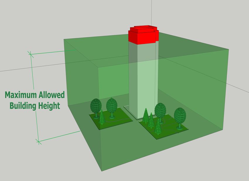
The International Archives of the Photogrammetry, Remote Sensing and Spatial Information Sciences, Volume XLIV-4/W1-2020, 2020
              3rd BIM/GIS Integration Workshop and 15th 3D GeoInfo Conference, 7–11 September 2020, London, UK

  existing building surrounding the proposed (planned)                 2018; Van Berlo et al., 2013), there is a lack of research with a
  construction, and legally binding land-use plan (a German            focus on the investigation about land-use regulation conflicts.
  standard) in the XplanGML format in which the objects are            For this reason, we decided to extend our literature review to
  represented as 2D geometries with corresponding attributes.          spatio-semantic data conflicts. For instance, Fileto (2001)
  They suggest converting the BIM data to CityGML format and           proposed a classification for conflicts that may arise by having
  then importing the building data to a city model where the rule      two or more sources of information in the context of relational
  checking will be carried out.                                        databases. He investigated these conflicts from two orthogonal
  Van Berlo et al. (2013) converted the spatial planning map into      aspects as follows.
  3D building objects by using the maximum allowed building                 x    Abstraction level
  height value given in the regulations. The main focus of their                     o Data instance conflicts (e.g. conflicts in units)
  work was on investigating four regulations including the                           o Schema conflicts (e.g. an attribute in one
  maximum allowed building volume, the maximum percentage                              relational schema that is modelled as a relation
  of the built area on the site, the maximum allowed noise value                       in another relational schema)
  on the façade of the buildings, and if protected cultural heritage                 o Data model conflicts (e.g. one database
  in the underground is not harmed by the designs. In their work,                      designed according to the relational model
  the rule checking is performed in a BIM environment in which                         while the other is object-oriented)
  the architects can conduct their own rule checks before                   x    Representation and interpretation level
  submitting the application for the building approval (e.g. using                   o Syntactic conflicts (i.e. discrepancies in the
  software such as Solibri Model Checker).                                             representation of data)
  Noardo et al. (2020) proposed a GeoBIM workflow (as part of                        o Semantic conflicts
  GeoBIM project) for issuing a building permit. The workflow          Wang and Hu (2009) described possible conflicts in a spatial
  has several steps including reading and using 3D city model and      data integration process and proposed a number of possible
  regulations that can be read by a computer, checking the BIM’s       solutions in dealing with these conflicts. They classified the
  validity, semantics and geo-referencing, conversion of BIM to        potential conflicts between different spatial data sources into
  CityGML, analysing the integrated information for checking the       three main classes including:
  picked city regulations, and building permit issuing. In addition,        x    System conflicts (when technical aspects such as
  in order to find the common regulation checks amongst the                      hardware platforms are different);
  municipalities of participating project partners, they proposed a         x    Syntax conflicts (mainly reflected on data models);
  classification by considering 3D spatial and semantic aspects of          x    Semantic conflicts (conflicts in the meaning,
  these regulations. They classified a number of common land-use                 interpretation or use of the data).
  regulation checks in European countries as:
        x    Zoning and dimensions (e.g. maximum height and            2.3 Clash detection in Building Information Modelling
             distances from other buildings);                          (BIM)
        x    Parking availability;
        x    The impact of building on environment and the             3D modelling and BIM, as a part of the literature review, were
             impact of environment on building (e.g.                   investigated, and the current approach of clash classification in
             overshadowing and air quality).                           BIM seemed quite applicable for the assessment of land-use
  Olsson et al. (2018) proposed an approach to automate the            regulation conflicts. For this reason, this section briefly explains
  process of issuing a building permit for three specific              the notion of “clash” as a special kind of spatial conflicts
  regulations including building height, building footprint area,      (Eastman et al., 2008; Matejka and Sabart, 2018; Mehrbod et
  and one visual criterion. Their study is based on the approach of    al., 2019; Reddy, 2011; Sampaio and Berdeja, 2017; Webster,
  importing the BIM model of new buildings, into a geospatial          1971). Subsequently, section (3.2.2) will explain its
  data environment in which municipalities carry out the legal         correspondence with our proposed classification for land-use
  check of the regulations. In addition, they proposed a               regulation conflicts.
  classification of the property criteria in Swedish detailed          Generally, clashes are only applicable to the BIM data and they
  development plans in which they classified the regulations into      cannot be applied in a data integration process in which there
  three main classes by taking to account the main available           are other kinds of models such as geospatial data (Eastman et
  source of datasets (i.e. BIM, geospatial, and integrated BIM and     al., 2008; Sampaio and Berdeja, 2017; Webster, 1971).
  geospatial data). The three classes are as follows:                  However, it can be considered as a part of a data integration
        x    Quantitative regulations, which can be checked            process when several parts of a BIM data are designed by
             automatically (e.g. building heights);                    different designers or architects and need to be integrated to
        x    Qualitative regulations, which are difficult to be        create the whole BIM data (that again it is only related to BIM
             checked automatically (e.g. maintenance of specific       data).
             historical and artistic values); and                      Matejka and Sabart (2018) categorize clashes in four types in
        x    Visual regulations, which can be supported digitally      the construction process including hard clashes, soft clashes, 4D
             (e.g. configuration of windows).                          clashes, and animated clashes (clashes of animated objects). The
  However, they did not provide any details about the                  last two clashes are related to the construction phase and they
  investigated regulations considered in their classification. They    are out of the scope of this paper.
  just presented the final percentage of regulations in each class.          x    Hard clashes refer to only geometrical issues in which
                                                                                  two or more building elements intersect or overlap
  2.2 Land-use regulation conflicts                                               (Reddy, 2011). They can be costly to fix if missed in
                                                                                  the design process (e.g. the collision of piping and a
  Despite the extensive research carried out in the last decade in                beam (column) as shown in Figure 2(a)).
  the field of land-use regulation and building permit issuance              x    Soft clashes are the clashes between one entity and
  (Benner et al., 2010; Noardo et al., 2019, 2020; Olsson et al.,                 another’s buffer area, which is set around it (Reddy,

                                              This contribution has been peer-reviewed.
               https://doi.org/10.5194/isprs-archives-XLIV-4-W1-2020-41-2020 | © Authors 2020. CC BY 4.0 License.                       43
The International Archives of the Photogrammetry, Remote Sensing and Spatial Information Sciences, Volume XLIV-4/W1-2020, 2020
3rd BIM/GIS Integration Workshop and 15th 3D GeoInfo Conference, 7–11 September 2020, London, UK
2011). As an example, Figure 2(b) illustrates a soft considered in this inventory include having 3D components
clash in which a column is placed right in front of a (e.g. height, depth, and volume of building elements or 3D
door. land-use regulations) and semantic aspects. Semantic aspects
will mainly facilitate understanding of potential semantic
conflicts for proposed (planned) buildings in a planning permit
process. For instance, window of a habitable room in a
proposed (planned) building should be distinguishable from the
other windows. In order to identify land-use regulations
comprising 3D components, more than 100 regulations (2D &
3D) that should be considered in the planning system were
reviewed and classified based on their characteristics into four
(a) (b) main classes as:
Figure 2. (a) Hard clash between a pipe and a beam; (b) Soft 1- Zoning and dimensioning: If the regulation has some rules
clash between a door and a beam. and criteria, which are the same for its entire zone (i.e. they
differ based on the characteristics of their zone), or they
x 4D clashes happen due to low quality in project are related to dimensions, they will be in this category.
management and occur during the construction phase Common regulations in this class are as follows:
(i.e. time is considered). The conflict between the x Site Coverage: Regulation related to that part of the
crane and scaffolding during the construction phase is proposed lot that is covered by buildings. It is often
an example of this clash. expressed as a percentage of the area of the land or
x Finally, animated clashes have a dynamic densification level.
characteristic such as people walking on stairs and x Building Height: The vertical distance between
through corridors, or components that require ground level and top of the roof.
manipulation space (e.g. moving a virtual person to x Street Setbacks (Max & Min): Regulation related to
inspect the correction of specified measurements the minimum and maximum distance from the
through corridors and stairs). These collisions are boundary of building to the street.
more similar to soft clashes with the differences in x Side and Rear Setbacks: It is related to the setback
using a dynamic buffer instead of the static one. from a side or rear boundary of the building.
Some other researchers have addressed the design conflict that x Private Open Space: Regulation related to an
occurs when a building component conflicts with another unroofed area of land, or a deck, terrace, patio,
building component in BIM designs (Akinci et al., 2002; Wu balcony, pergola, veranda, gazebo, swimming pool, or
and Chiu, 2010). The conflicts are related to the design phase spa.
when a building component conflicts with another. One x Walls and Carports on Boundaries: Regulation related
alternative to identify design conflicts, as well as clashes, is to to a wall or carport of a building constructed on its
define some validation rules in order to reduce the potential side or rear boundary.
issues (Ledoux, 2018; Shojaei et al., 2017). For example, in the x Car Parking Spaces: Number of car parking spaces,
city of Melbourne, the first phase of cadastral applications is to underground and in covered areas.
check the plan by several validation rules to verify its Table 1 summarises these regulations by describing their 3D
consistency in terms of design conflicts (Shojaei et al., 2017). components and semantic aspects.
3. MODELLING 3D LAND-USE REGULATIONS Reg. Name 3D Components Semantic Aspects
x Information related to swimming
This section proposes the main contributions of this paper, x Different pools or spas, unroofed terraces,
which are an inventory of land-use regulations comprising 3D Site Coverage vertical levels unroofed patios, unroofed decks and
components and functional classification of their possible of buildings pergolas
conflicts when representing them in 3D (based on the x Width of eaves, fascia and gutters
x Height of x Type of entities (e.g. the height of
magnitude of their impacts on issuing building permits). These Building Height building ventilation and air conditioning,
two results seek to extend our understanding of any specific elements entrance storey, etc.)
land-use regulation conflict situation and facilitate the decision- x Overhanging
x Type of street setbacks (i.e. side or
making process for issuing building permits in our case for the Street Setbacks rear)
objects like
(Side and Rear) x Type of streets (i.e. narrow,
intended users. balconies
medium, and wide)
x Overhanging
Side and Rear x Type of setbacks (i.e. side or rear)
3.1 Inventory of land-use regulations comprising 3D Setbacks
objects like
x Type of boundaries
components balconies
x Information related to a deck,
Private Open x Overhanging terrace, patio, balcony, pergola,
The inventory identifies the land-use regulations that comprise Space objects veranda, gazebo, swimming pool or
3D components and distinguish semantic aspects of regulations. spa
In this part, the most common land-use regulations that need to Walls and x Type of walls
x The height of
be checked for issuing a building permit (as a use-case) are Carports on x Type of boundaries (e.g. side and
walls
Boundaries rear)
reviewed. These regulations are based on “Building Regulations
2018, Authorised Version No. 001, S.R. No. 38/2018” of the Car Parking x Underground x Functionality of car parking spaces
Victorian Government2 in Australia. Based on the work of Spaces spaces (e.g. bikes, cars).
Noardo et al. (2020), the following tables show our proposed
Table 1. Zoning and dimensioning regulations
inventory of land-use regulations. The main characteristics
2 http://www.legislation.vic.gov.au
This contribution has been peer-reviewed.
https://doi.org/10.5194/isprs-archives-XLIV-4-W1-2020-41-2020 | © Authors 2020. CC BY 4.0 License. 44The International Archives of the Photogrammetry, Remote Sensing and Spatial Information Sciences, Volume XLIV-4/W1-2020, 2020
3rd BIM/GIS Integration Workshop and 15th 3D GeoInfo Conference, 7–11 September 2020, London, UK
2- Lights and shadows: If the regulation is related to sun or 3.2 Land-use regulation conflicts
skylight and shadow, it will be in this category. Common
regulations in this class are as follows: After exploring different land-use regulations, and in order to
x Daylight to Existing Habitable Room Windows: The enhance the current decision-making process for urban planners
natural light of the day for existing buildings in a situation where many land-use regulations are involved,
adjoining proposed (planned) building. this section presents the possible conflicts that may arise in a
x Solar Access to Existing north-facing Habitable building permit process. To this purpose, the conflicts are
Room Windows: Based on Victorian government reviewed by considering two aspects. First, we have traced the
definition, “north-facing window means a window of land-use regulation conflicts based on the traditional way of
a room that has an axis perpendicular to its surface examining a spatial data integration process including spatial,
oriented true north 20° west to true north 30° east”. semantic, and temporal conflicts (Fileto, 2001; Mohammadi,
x Overshadowing of Recreational Private Open Space: 2008; Wang and Hu, 2009). This classification aims to group
Recreational private open spaces are generally land-use regulation conflicts by considering the heterogeneity of
intended for outdoor recreation activities. the sources of data. Second, the magnitude of land-use
x Daylight to Habitable Room Windows: The natural regulation conflicts that influences the decision of issuing or
light of the day for a proposed (planned) building. rejecting a building permit is investigated.
Table 2 summarises the aforementioned regulations by
describing their 3D component and semantic aspects. 3.2.1 Classification of land-use regulation conflicts
This classification will mainly help the users in a data
Reg. Name 3D Components Semantic Aspects
integration process in order to know several conflicts that may
Daylight to
Existing Habitable
x The height of adjoining
x Type of windows arise by the integration of different datasets in a building permit
walls process. The proposed classification includes three main classes
Room Windows
Solar Access to named spatial (geometric and topologic sub-classes), semantic
Existing north-
x Building height x Type of windows (syntactic, structural or schematic, and sense or meaning sub-
facing Habitable
Room Windows classes), and temporal conflicts. Table 4 summarises the
Overshadowing of x Height of proposed proposed classification by bringing several examples in a
Recreational (planned) building
x Type of open spaces building permit process, and the classes are explained in more
Private Open x Height of adjoining detail afterward.
Space buildings
x Information related
Daylight to x Height of building Type of
to veranda, porch, Sub-Class Examples in the building permit process
Habitable Room elements in room’s front Conflict
deck or balcony, and
Windows outdoor space 1) Having a 2D architectural plan and a 3D city
carports
model
Table 2. Lights and shadows regulations Geometric
2) Having BIM data with no information about
Spatial
the coordinate system
3- Viewshed: It is related to the line of sight. Intersection or overlap between two lots
Topologic
x Overlooking: A bedroom on a proposed (planned) boundaries
building must not provide a direct line of sight to Syntactic Apartment and Apt
adjoining bedrooms in neighbouring buildings. The hierarchical level of internal parts of a building
Structural
in two datasets may cause conflict when it is a data
x Projections beyond Street Alignment: Street Semantic
or
value in one relational schema and a relation in
alignment means the line between a street and an schematic
another relational schema.
allotment. Sense or 1) Floor and Storey
Table 3 summarises these two regulations by describing their meaning 2) Habitable room and Bedroom
3D component and semantic aspects. If two BIMs in the same neighborhood at the same
Date time request a building permit, temporal conflicts
may arise.
Reg. Name 3D Components Semantic Aspects Temporal Some regulations depend on the existing buildings
x Height of the and density of a zone. For example, after reaching
x Type of windows Duration
window of habitable a specific number of buildings, the changes over
x Information related to a the time in regulations are predictable.
room in planned /
Overlooking balcony, a terrace, a deck or a Table 4. Classification of possible conflicts by integrating
existing buildings
patio
x Height of the level of different sources of information
x Type of open spaces
habitable room
x Information related to the type
Projections of entities (Balconies, x Spatial Conflicts: In the data integration process, the first
x Overhanging objects
beyond Street Verandas, etc.) important part that describes the geometric and
like balconies
Alignment x Type of streets (i.e. Narrow, topological inconsistencies is considered as spatial
Medium, and Wide)
conflicts.
Table 3. Viewshed regulations o Geometric: For spatial conflicts with a
4- Uncommon regulations: Those regulations that are very geometric aspect, first, position and coordinate
specific in a jurisdiction, and do not belong to the previous systems and second, shape (linked to the dimension of
classes. For example, there is a number of regulations for the point 0D, line 1D, surface 2D or polyhedron 3D
“Fences” comprising 3D components such as front fence primitives), size (scale factor), and orientation of the
height and fence setbacks from side and rear boundaries. entities should be taken into account.
o Topologic: It considers the conflicts that arise
based on the interior, boundary, and exterior parts of
the objects. Having polygons with non-planar surfaces
or having intersection between edges or polygons are
some examples of topological conflicts. It should be
This contribution has been peer-reviewed.
https://doi.org/10.5194/isprs-archives-XLIV-4-W1-2020-41-2020 | © Authors 2020. CC BY 4.0 License. 45The International Archives of the Photogrammetry, Remote Sensing and Spatial Information Sciences, Volume XLIV-4/W1-2020, 2020
3rd BIM/GIS Integration Workshop and 15th 3D GeoInfo Conference, 7–11 September 2020, London, UK
noted that when there is only one dataset, these x Hard = CityGML LoD 2 & LoD 3
conflicts could be equivalent to design conflicts. 5) The 3D spatial configuration of the land-use regulations
x Semantic Conflicts: Semantic conflicts correspond to causing the conflict: It refers to the shapes utilised to model
disagreement over the meaning, understanding, or the land-use regulations.
intended use of the same or similar information (Fileto, x Soft = regular solid
2001). Generally, these conflicts can be discussed in x Hard = irregular 3D shapes (could be line,
three levels, including: surface, or solid)
o Syntax level: It is related to conflicts in terms of Finally, based on the proposed variables, the number of soft and
characters (strings). hard conflicts is counted, and the conflict belongs to the class
o Structure or schema level: It considers whether that is outnumbered.
the same term in one dataset is located at the same For instance, as is shown in Figure 3, the highest object of the
level in the data model (or schema) of another dataset. proposed (planned) building must not exceed the maximum
o Sense or meaning level: It consists of the allowed height regulation. If it does, in this case, the conflict
conflicts that may occur between meanings of the consists of one regulation (i.e. building height regulation) and
terms. mostly one building object (i.e. the roof of the proposed
x Temporal Conflicts: Temporal conflicts are notable in (planned) building). In addition, for identifying the conflict,
two terms of “date” and “duration”. Temporal conflicts since the roof shape of the proposed (planned) building is
can greatly affect the building permit process. As an required, at least LoD 2 is needed, and adjoining existing
example of conflicts related to date, consider two high- buildings are not required. Finally, a regular solid (i.e. cuboid)
rises in the same neighbourhood applying for the can model the height regulation. Therefore, according to
building permits. In this case, based on the date of proposed variables, the magnitude of this conflict is “Soft” as is
application, the second one should not restrict rights summarised in table 5.
associated with the first one. For example, the second
submitted application cannot restrict solar access to the Planned No. of
No. of
LoD LoD
Spatial
Class of
building configuration
first submitted application. building regulations
objects
“P” “S”
of regulation
conflict
Not
Value 1 1 2 Regular Solid
required
3.2.2 Magnitude of land-use regulation conflicts Soft
Magnitude Conflict
Soft Soft Hard - Soft
of conflict
As mentioned before, to support our hypothesis, we now
propose a way of ranking the conflicts between the proposed Table 5. Classification of the magnitude of building height
planned building with physical objects and land-use regulations. regulation conflict
We do believe that this classification will improve the decision-
making process in issuing a building permit, more specifically
in the integration of spatio-semantic data. Similar to clash
classification in BIM (i.e. hard and soft clashes), two conflict’s
magnitudes for land-use regulations are proposed (i.e. hard and
soft conflicts). In the proposed classification, unlike BIM
clashes in which the main entities are building elements, the
main entities are land-use regulations. Soft conflicts can be
recognized or resolved with a limited number of data analysis
by the decision-makers. While hard conflicts include situations
that are more complex, for which decision-makers require a
higher level of data analysis and knowledge. In the following,
first, the proposed variables for evaluating the amount of data
analysis are indicated and then, they are explained by three
concrete examples.
1) The number of land-use regulations involved in the conflicts.
x Soft = 1 Figure 3. Building height regulation conflict (in RED colour)
x Hard ≥ 2
2) The number of physical (building) objects involved in the On the other hand, if the proposed (planned) building respects
conflicts. the height regulation, it may restrict the solar access of the other
x Soft < 2 buildings or cause a shadow in its adjoining building as is
x Hard ≥ 2 illustrated in Figure 4. In this scenario, the conflict consists of
3) The level of detail3 of the planned building (LoD “P”). two regulations (i.e. building height and overshadowing
x Soft = CityGML LoD 1 (or equivalent in BIM regulations) and two building objects (i.e. the roof of the
modelling) planned building and private open space of existing buildings).
In addition, for identifying the conflict, since the roof shape of
x Hard = CityGML LoD 2 & LoD 3 (or
the proposed (planned) building and the private open space of
equivalent in BIM modelling)
existing adjoining buildings are needed, at least LoD 2 is
4) The level of detail of surrounding buildings (LoD “S”).
required for the proposed (planned) building, and for the
x Soft = CityGML LoD 1
existing buildings, LoD 3 is needed. Finally, a regular solid
cannot model shadow regulation. Therefore, according to
3 Level of Detail (LoD) refers to the degree of detail used to model the proposed variables, the magnitude of this conflict is “Hard” as
city objects (planned building or existing buildings). For this version is summarised in table 6.
and as a first appraisal, we assume the 3D city model is based on
CityGML but in fact, it could be any 3D modelling design.
This contribution has been peer-reviewed.
https://doi.org/10.5194/isprs-archives-XLIV-4-W1-2020-41-2020 | © Authors 2020. CC BY 4.0 License. 46The International Archives of the Photogrammetry, Remote Sensing and Spatial Information Sciences, Volume XLIV-4/W1-2020, 2020
3rd BIM/GIS Integration Workshop and 15th 3D GeoInfo Conference, 7–11 September 2020, London, UK
Planned No. of
No. of
LoD LoD
Spatial
Class of Obviously, after having ranked the conflicts between the
building configuration of
building regulations
objects
“P” “S”
regulation
conflict planned building and the land-use regulations, the data
Value 2 2 2 3 irregular shape processing does not stop there; we afterward have to fix the
Hard
Magnitude
Hard Hard Hard Hard Hard Conflict conflict. As indicated, this paper presents the progress of an
of conflict ongoing research project, and one of the next steps is exactly to
Table 6. Classification of the magnitude of building height and provide analytical tools to meet this need.
overshadowing regulations conflict
4. CONCLUSION AND FUTURE STEPS
This paper firstly explored the land-use regulations and then,
the possible conflicts that may arise in the issuance of a
building permit. The inventory of land-use regulations
demonstrated that many land-use regulations contain 3D
components (e.g. building height, solar access, daylight, and
shadowing), which make the decision-making process a
challenging task with traditional 2D systems. Accordingly, after
exploring land-use regulations, two classifications to identify
and evaluate the conflicts are proposed from two points of view
(i.e. data sources, and magnitude of conflicts). Since the
building permit process is a common process in different
territories, the results can be applied to other jurisdictions with
some minor changes. The main value of these classifications are
to extend our understanding of 3D land-use regulation and to
Figure 4. Hard conflict between building height and
support decision-makers in the detection of spatio-semantic
overshadowing regulations (the grey is the planned
conflicts between the planned building, the existing buildings,
building (left) and the other is the existing building
and the land-use regulations. We also believe that they will
(right))
contribute to model and visualize land-use regulations as part of
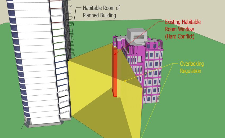
As another example, as is shown in Figure 5, for checking
the 3D city modelling (CityGML and BIM). The classification
overlooking regulation, the window of a habitable room of the
system for the magnitude of the conflicts is not yet fully
proposed (planned) building must not provide a direct line of
validated, neither confronted with a concrete decision-making
sight to the windows of a habitable room in existing buildings.
process, and this is part of the upcoming work. For example, the
If it does, in this case, the conflict consists of one regulation
aggregation of the variables needs to be validated with users.
(i.e. overlooking regulation) and two building objects (i.e. the
We are currently working on the design of a use-case to detect
window of a habitable room in the proposed (planned) building
spatio-semantic conflicts inspired by issuing building permits
and the window of a habitable room in the existing adjoining
and its implementation with 3D city models for the city of
building). In addition, for identifying the conflict, since the
Melbourne.
windows should be modelled, the LoD 3 is needed for both
proposed (planned) and existing buildings. Finally, a regular
ACKNOWLEDGEMENTS
solid (i.e. triangular prism) can model the overlooking
regulation. Therefore, according to proposed variables, the This project is funded by NSERC RGPIN-2015-05514
magnitude of this conflict is “Hard” as is summarised in table 7. (JPouliot). The authors would like to thank Ordnance Survey
No. of Spatial
GB (https://www.ordnancesurvey.co.uk) and 1Spatial
Planned No. of LoD LoD Class of (https://1spatial.com/) for sponsoring the publication of this
building configuration of
building regulations “P” “S” conflict
objects regulation paper.
Value 1 2 3 3 Regular Solid
Hard
Magnitude Conflict
of conflict
Soft Hard Hard Hard Soft REFERENCES
Table 7. Classification of the magnitude of overlooking Akinci, B., Fischen, M., Levitt, R., Carlson, R., 2002.
regulation conflict Formalization and automation of time-space conflict analysis. J.
Comput. Civ. Eng. 16, 124–134.
Arnold, C.A., 2006. The structure of the land use regulatory
system in the United States. J. L. Use Envtl. L. 22, 441.
Benner, J., Geiger, A., Häfele, K.-H., 2010. Concept for
building licensing based on standardized 3D geo information,
in: Proceedings of the 5th International 3D GeoInfo
Conference, Berlin, Germany. pp. 3–4.
Biljecki, F., Stoter, J., Ledoux, H., Zlatanova, S., Çöltekin, A.,
2015. Applications of 3D city models: State of the art review.
ISPRS Int. J. Geo-Information 4, 2842–2889.
Cann, D.M., 2018. The structure of municipal political
Figure 5. Overlooking regulation conflict (in RED colour) ideology. State Local Gov. Rev. 50, 37–45.
This contribution has been peer-reviewed.
https://doi.org/10.5194/isprs-archives-XLIV-4-W1-2020-41-2020 | © Authors 2020. CC BY 4.0 License. 47The International Archives of the Photogrammetry, Remote Sensing and Spatial Information Sciences, Volume XLIV-4/W1-2020, 2020
3rd BIM/GIS Integration Workshop and 15th 3D GeoInfo Conference, 7–11 September 2020, London, UK
Döllner, J., Baumann, K., Buchholz, H., 2006a. Virtual 3D city purpose of virtual 3D city model. ISPRS Int. J. Geo-Information
models as foundation of complex urban information spaces, in: 7, 194.
Proceedings of the 11th International Conference on Urban
Planning and Spatial Development in the Information Society, Noardo, F., Arroyo Ohori, K., Biljecki, F., Krijnen, T., Ellul,
Vienna, Austria, 13–16 February 2006. C., Harrie, L., Stoter, J., 2019. Geobim benchmark 2019:
Design and initial results. Int. Arch. Photogramm. Remote Sens.
Döllner, J., Kolbe, T.H., Liecke, F., Sgouros, T., Teichmann, Spat. Inf. Sci. - ISPRS Arch. 42, 1339–1346.
K., 2006b. The virtual 3d city model of berlin-managing, https://doi.org/10.5194/isprs-archives-XLII-2-W13-1339-2019
integrating, and communicating complex urban information, in:
Proceedings of the 25th International Symposium on Urban Noardo, F., Ellul, C., Harrie, L., Overland, I., Shariat, M.,
Data Management UDMS 2006 in Aalborg, Denmark, 15-17 Arroyo Ohori, K., Stoter, J., 2020. Opportunities and challenges
May 2006. for GeoBIM in Europe: developing a building permits use-case
to raise awareness and examine technical interoperability
Durham Jr, W.C., Scharffs, B.G., 2019. Law and religion: challenges. J. Spat. Sci. 65, 209–233.
National, international, and comparative perspectives. Wolters https://doi.org/10.1080/14498596.2019.1627253
Kluwer Law & Business.
Olsson, P.-O., Axelsson, J., Hooper, M., Harrie, L., 2018.
Eastman, C., Teicholz, P., Sacks, R., Liston, K., Handbook, Automation of building permission by integration of BIM and
B.I.M., 2008. A guide to building information modeling for geospatial data. ISPRS Int. J. Geo-Information 7, 307.
owners, managers, designers, engineers and contractors. Reddy, K.P., 2011. BIM for building owners and developers:
making a business case for using BIM on projects. John Wiley
Fileto, R., 2001. Issues on interoperability and integration of & Sons.
heterogeneous geographical data, in: Proceedings of the Third
Brazilian Symposium on Geoinformatics. Salsich, P.W., Tryniecki, T.J., 1998. Land use regulation: A
legal analysis & practical application of land use law. Real
Forester, J., 1987. Planning in the face of conflict: Negotiation Property Probate and Trust Law American Bar Association.
and mediation strategies in local land use regulation. J. Am.
Plan. Assoc. 53, 303–314. Sampaio, A.Z., Berdeja, E., 2017. Collaborative BIM
environment as a support to conflict analysis in building design,
Gresch, P., Smith, B., 1985. Managing spatial conflict: the in: 2017 4th Experiment@ International Conference (Exp.
planning system in Switzerland. Prog. Plann. 23, 155–251. at’17). IEEE, pp. 77–82.
Grimmer, N.G., 2007. Opps-It Turns out You Shouldn’t Have Selmi, D.P., Kushner, J.A., Ziegler, E.H., DiMento, J.F.C.,
Built That There: Erroneously Issued Building Permits in Echeverria, J., 2017. Land use regulation: cases and materials.
Texas. Hous. L. Rev. 44, 1415. Wolters Kluwer Law & Business.
Kochan, D.J., 2014. A framework for understanding property Shojaei, D., Olfat, H., Faundez, S.I.Q., Kalantari, M.,
regulation and land use control from a dynamic perspective. Rajabifard, A., Briffa, M., 2017. Geometrical data validation in
Mich. J. Envtl. Admin. L. 4, 303. 3D digital cadastre− A case study for Victoria, Australia. Land
use policy 68, 638–648.
Kolbe, T.H., 2009. Representing and exchanging 3D city
models with CityGML, in: 3D Geo-Information Sciences. Stadler, A., Kolbe, T.H., 2007. Spatio-semantic coherence in
Springer, pp. 15–31. the integration of 3D city models, in: Proceedings of the 5th
International ISPRS Symposium on Spatial Data Quality
Ledoux, H., 2018. val3dity: validation of 3D GIS primitives ISSDQ 2007 in Enschede, The Netherlands, 13-15 June 2007.
according to the international standards. Open Geospatial Data,
Softw. Stand. 3, 1. Van Berlo, L., Dijkmans, T., Stoter, J.E., 2013. Experiment for
inegrating Dutch 3D spatial planning and BIM for checking
Matejka, P., Sabart, D., 2018. Categorization of clashes and building permits, in: 8th 3DGeoInfo Conference & WG II/2
their impacts on construction projects, in: International Workshop, Istanbul, Turkey, 27–29 November 2013, ISPRS
Scientific Conference Engineering for Rural Development, 23rd Archives Volume II-2/W1. ISPRS.
to 25th May, Jelgava, Available at: Www. Tf. Llu.
Lv/Conference/Proceedings2018/Papers N. Wang, Y., Hu, S., 2009. Spatial Data Integration and Conflicts
Resolving Approaches, in: 2009 International Conference on
Mayer, C.J., Somerville, C.T., 2000. Land use regulation and Information Management, Innovation Management and
new construction. Reg. Sci. Urban Econ. 30, 639–662. Industrial Engineering. IEEE, pp. 355–358.
Mehrbod, S., Staub-French, S., Mahyar, N., Tory, M., 2019.
Beyond the clash: investigating BIM-based building design Webster, N., 1971. Webster’s Third New International
coordination issue representation and resolution. ITcon 24, 33– Dictionary of the English Language, Unabridged: A Merriam-
57. Webster. Editor in Chief: Philip Babcock Gove and the
Merriam-Webster Editorial Staff. G. & C. Merriam Company.
Mohammadi, H., 2008. The Integration of multi-source spatial
datasets in the context of SDI Initiatives. Citeseer. Wu, I., Chiu, Y., 2010. 4D Workspace conflict detection and
analysis system, in: Proceedings of the 10th International
Neuville, R., Pouliot, J., Poux, F., De Rudder, L., Billen, R., Conference on Construction Applications of Virtual Reality.
2018. A formalized 3D geovisualization illustrated to selectivity
This contribution has been peer-reviewed.
https://doi.org/10.5194/isprs-archives-XLIV-4-W1-2020-41-2020 | © Authors 2020. CC BY 4.0 License. 48You can also read