Almond Valley-Phase 1 Application Habitats Regulations Appraisal - March 2021
←
→
Page content transcription
If your browser does not render page correctly, please read the page content below
Almond Valley- Phase 1 Application
Habitats Regulations Appraisal

March 2021
Almond Valley- Phase 1 Application
Habitats Regulations Appraisal

Client:                Savills (on behalf of Pilkington Trust and Stewart Milne Group)

Document number:       9014
Project number:        173189
Status:                Final

Author:                Ian Buchan
Reviewer:              G Duff

Date of issue:         9 March 2021

 Glasgow                            Aberdeen                   Inverness                   Edinburgh

 Craighall Business Park            Banchory Business          Alder House                 1st Floor, Sirius
 8 Eagle Street                     Centre                     Cradlehall Business Park    Building, The
 Glasgow                            Burn O’Bennie Road         Inverness                   Clocktower Estate,
 G4 9XA                             Banchory                   IV2 5GH                     South Gyle Crescent,
 0141 341 5040                      AB31 5ZU                   01463 794 212               Edinburgh, EH12 9LB
 info@envirocentre.co.uk            01330 826 596
 www.envirocentre.co.uk

This report has been prepared by EnviroCentre Limited with all reasonable skill and care, within the terms of
the Contract with Savills (on behalf of Pilkington Trust and Stewart Milne Group) (“the Client”). The report is
confidential to the Client, and EnviroCentre Limited accepts no responsibility of whatever nature to third
parties to whom this report may be made known.

No part of this document may be reproduced or altered without the prior written approval of EnviroCentre
Limited.
Savills (on behalf of Pilkington Trust and Stewart Milne Group) March 2021
Almond Valley- Phase 1 Application; Habitats Regulations Appraisal
EXECUTIVE SUMMARY
EnviroCentre Limited was commissioned by Savills, on behalf of the Pilkington Trust and Stewart Milne
Group, in December 2019 to undertake a Habitats Regulations Appraisal (HRA) for the proposed Almond
Valley Phase 1/1A and associated Primary Route Development.
The application for the ‘primary vehicular access’, as originally submitted in August 2019, included new
elements that were not part of the original application (15/01157/IPM), which was granted planning
permission in principle by the Reporter in September 2017. The differences proposed in the August 2019
application involved the culverting and realignment of the Perth Lade in two places and the construction of
a new road on an embankment cutting through the green corridor of the Lade. An HRA was completed on
the basis of the August 2019 applications in December 2019.
In the spring of 2020, Envirocentre were made aware of design proposal changes which would affect the
conclusions of the 2019 HRA.
The proposed changes related to the alignment of the primary route. In particular, the changes removed the
requirement to re-route the Lade as the roads cross directly over the existing alignment of the watercourse.
However, although the need to divert the Lade B was removed, it is still necessary to cross the Lade B in two
additional locations when compared with the initial Planning Permission in Principle consent from 2017. The type,
size and length of the actual road crossings at the Lade remain unchanged to that assessed in the 2019 HRA.
It is now that case that there is also a need for three cycle-bridge crossings of the Lade.
Due to the proximity of works to European designated sites, a HRA remains as a requirement to determine
the effect of the proposals on the qualifying features of the following designated site:
The River Tay Special Area of Conservation (SAC)
The proposed changes to the road alignment and the addition of the active travel links result in a reduced
footprint of works directly associated with the Lade and a subsequent reduced risk of impacting the associated
habitats.
As the proposed road realignment removes the requirement to re-route the Lade at two locations, the impacts
will be reduced from those considered during the 2019 HRA. In addition, the prospective active travel links are
considered to bring similar impacts as the road crossings albeit on reduced in scale. On this basis, we consider the
2019 HRA and the mitigation measures contained within it to adequately apprise the proposed realignment and
active travel links.
The overall HRA conclusion is therefore that it was not possible to rule out Likely Significant Effects (LSEs) of
all the qualifying features of River Tay SAC during the HRA screening process. Therefore, the effects on the
qualifying features are taken forward for further consideration in the next HRA stage, an Appropriate
Assessment.
The Appropriate Assessment concludes that if mitigation measures outlined within the EIA Report (EIAR) are
adhered to, along with the mitigation described in Section 7 of this report, then there will be no significant
effects on the integrity of the designated site regarding the conservation objectives for the sites’ qualifying
features.
i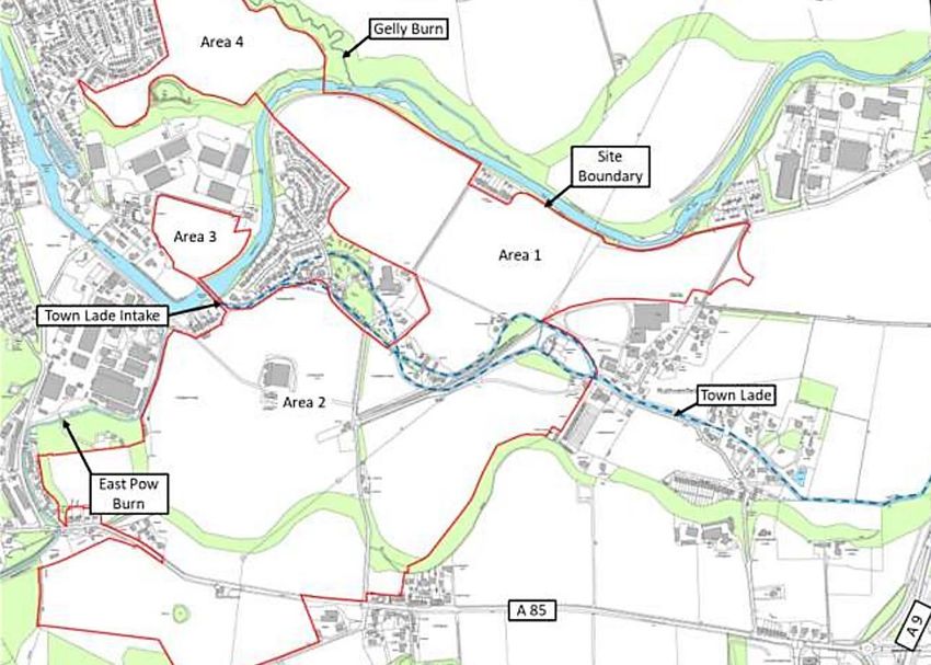
Savills (on behalf of Pilkington Trust and Stewart Milne Group)                                                                                        March 2021
Almond Valley- Phase 1 Application; Habitats Regulations Appraisal

Contents
Executive Summary ................................................................................................................................................... i
1    Introduction ..................................................................................................................................................... 1
     1.1 Terms of Reference ................................................................................................................................. 1
     1.2 Scope of Report ....................................................................................................................................... 1
     1.3 Report Usage ........................................................................................................................................... 1
2    Methods .......................................................................................................................................................... 4
3    Description of Proposed Development............................................................................................................ 6
     3.1 Site Location ............................................................................................................................................ 6
     3.2 Development Description ....................................................................................................................... 6
4    Screening for Likely Significant Effects .......................................................................................................... 16
     4.1 Relevant European Sites ........................................................................................................................ 16
     4.2 Zone of Influence for the Proposed Development ................................................................................ 17
5    Appropriate Assessment................................................................................................................................ 20
     5.1 Clear water lakes or lochs with aquatic vegetation and poor to moderate nutrient levels (Oligotrophic
          to mesotrophic standing waters with vegetation of the Littorelletea uniflorae and/or of the Isoëto-
          Nanojuncetea) ...................................................................................................................................... 21
     5.2 Atlantic Salmon (Salmo salar) and Brook, River and Sea Lamprey (Lampetra planeri, Lampetra
          fluviatilis, Petromyzoan marinus) .......................................................................................................... 21
     5.3 Otter ...................................................................................................................................................... 22
6    In-combination Effects ................................................................................................................................... 23
7    Mitigation ...................................................................................................................................................... 24
References ............................................................................................................................................................. 26

Figures
Figure 3-1 Perth Lade ...............................................................................................................................................6
Figure 3-2 Road alignment assessed in 2019 HRA ...................................................................................................7
Figure 3-3 Revised road alignment without any Lade re-routing                                                                                                        8
Figure 3-4 Location Plan ...........................................................................................................................................9
Figure 3-5 Original Application Submission 2019: Road Layout ............................................................................10
Figure 3-6 Original Application Submission 2019: Road Layout (2) .......................................................................11
Figure 3-7 May 2020 Primary Route Layout Design Update ..................................................................................12
Figure 3-8 Road Layout Update with active travel links…………………………………………………………………………………….13

Tables
Table 2-1 Key Stages in the HRA Process ........................................................................................................... 4
Table 3-1 Perth Lade Structures .......................................................................................................................... ..14
Table 4-1 River Tay SAC with Their Qualifying Features and Screening Assessment for Likely Significant Effects.18

                                                                                                                                                                         ii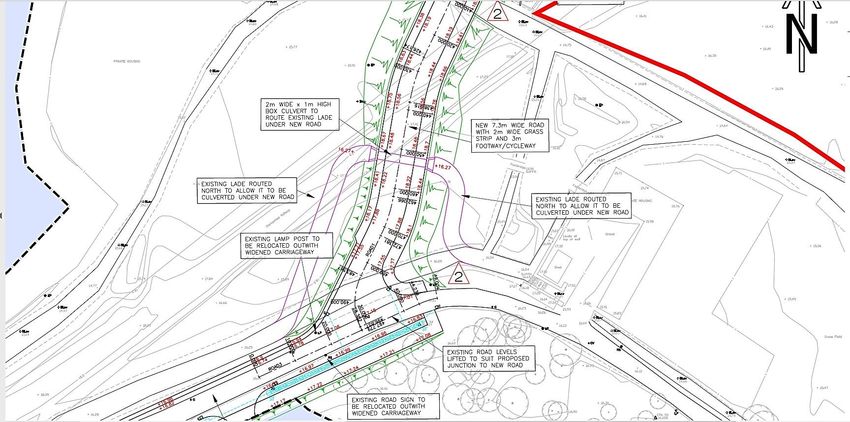
Savills (on behalf of Pilkington Trust and Stewart Milne Group)                                       March 2021
Almond Valley- Phase 1 Application; Habitats Regulations Appraisal

1 INTRODUCTION

1.1 Terms of Reference
Due to the location of the proposed works in proximity to a European designated (Natura 2000) site (River Tay
Special Area of Conservation (SAC)) a Habitats Regulations Appraisal (HRA) is required under The Conservation
(Natural Habitats, &c.) Regulations 1994 (as amended in Scotland) to assess potential impacts to the sites’
qualifying features. The River Tay SAC is adjacent to the northern boundary of the site and is designated for otter,
Atlantic salmon, river lamprey, brook lamprey and sea lamprey

1.2 Scope of Report
The proposed area of works is in proximity to, and may be hydrologically or ecologically connected to, a European
designated site which forms part of the Natura 2000 network. As such an HRA is required to assess whether the
project, alone or in combination with other projects, will have an adverse impact on the integrity of any of the
European designated sites. It is the responsibility of the competent authority to conduct the HRA. This document
aims to provide the information necessary for them to carry out Stage One of the assessment (Screening) by:

     •          Providing a description of the proposed works;
     •          Identifying those European designated sites which are connected to and/or could potentially be
                affected by the proposed works;
     •          Identifying how the proposed works may impact on the qualifying features of the designated sites;
     •          Considering other projects which may have “in combination” effects on the European designated
                sites; and
     •          Recommending the designated sites which need to be taken forward for further assessment if
                impacts on their qualifying features cannot be ruled out.

1.3 Report Usage
The information and recommendations contained within this report have been prepared in the specific context
stated above and should not be utilised in any other context without prior written permission from
EnviroCentre.

If this report is to be submitted for regulatory approval more than 12 months following the report date, it is
recommended that it is referred to EnviroCentre for review to ensure that any relevant changes in data, best
practice, guidance or legislation in the intervening period are integrated into an updated version of the report.

Whilst the Client has a right to use the information as appropriate, EnviroCentre Ltd retain ownership of the
copyright and intellectual content of this report. Any distribution of this report should be controlled to avoid
compromising the validity of the information or legal responsibilities held by both the Client and EnviroCentre
Ltd (including those of third party copyright). EnviroCentre do not accept liability to any third party for the
contents of this report unless written agreement is secured in advance, stating the intended use of the
information.

EnviroCentre accept no liability for use of the report for purposes other than those for which it was originally
provided, or where EnviroCentre have confirmed it is appropriate for the new context.

                                                                                                                    1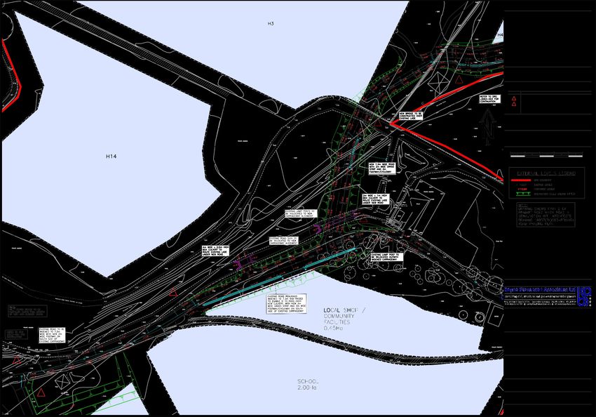
Savills (on behalf of Pilkington Trust and Stewart Milne Group)                                         March 2021
Almond Valley- Phase 1 Application; Habitats Regulations Appraisal

1.4         Legislative Context
The Council Directive 92/43/EEC on the conservation of natural habitats and of wild fauna and flora (hereafter
called the Habitats Directive) requires ‘appropriate assessment’ of plans and projects that are likely to have a
significant effect on European designated Natura 2000 sites.

Article 6(3) establishes the requirement for Appropriate Assessment (AA):

“Any plan or project not directly connected with or necessary to the management of the [Natura 2000] site but
likely to have a significant effect thereon, either individually or in combination with other plans and projects,
shall be subjected to appropriate assessment of its implications for the site in view of the site’s conservation
objectives. In light of the conclusions of the assessment of the implication for the site and subject to the
provisions of paragraph 4, the competent national authorities shall agree to the plan or project only after
having ascertained that it will not adversely affect the integrity of the site concerned and, if appropriate, after
having obtained the opinion of the general public”.

Article 6(4) goes on to discuss alternative solutions, the test of ’imperative reasons of overriding public interest’
(IROPI) and compensatory measures:

“If, in spite of a negative assessment of the implications for the site and in the absence of alternative solutions,
a plan or project must nevertheless be carried out for imperative reasons of overriding public interest, including
those of a social or economic nature, the Member State shall take all compensatory measures necessary to
ensure that the overall coherence of Natura 2000 is protected. It shall inform the Commission of the
compensatory measures adopted”.

Should a decision be reached to the effect that it cannot be said with sufficient certainty that the development
will not have any significant effect on the Natura site, then, as stated above, it is necessary and appropriate to
carry out an AA of the implications of the development for the sites in view of their conservation objectives.

The EEC (2001) guidance for AA states (Section 3.2 pg. 25):

“It is the competent authority’s responsibility to carry out the Appropriate Assessment. However, the
assessment process will include the gathering and consideration of information from many stakeholders,
including the project or plan proponents, national, regional and local nature conservation authorities and
relevant NGOs. As with the EIA process, the Appropriate Assessment will usually involve the submission of
information by the project or plan proponent for consideration by the competent authority. The authority may
use that information as the basis of consultation with internal and external experts and other stakeholders. The
competent authority may also need to commission its own reports to ensure that the final assessment is as
comprehensive and objective as possible.

In this stage, the impact of the project or plan (either alone or in combination with other projects or plans) on
the integrity of the Natura 2000 site is considered with respect to the conservation objectives of the site and to
its structure and function.”

1.4.1     Special Areas of Conservation (SACs)

SACs are designated under Article 3 of the Habitats Directive 92/43/EEC of 21 May 1992 on the conservation of
natural habitats and of wild fauna and flora, as part of the Natura 2000 network. It is transposed into Scottish
law through the Conservation (Natural Habitats, &c.) Regulations 1994 (as amended). This network comprises
Annex I habitats - "natural habitat types of community interest whose conservation requires the designation of
Special Areas of Conservation" and the habitats of Annex II species - "animal and plant species of community
interest whose conservation requires the designation of Special Areas of Conservation". Candidate SACs (cSACs)

                                                                                                                       2
Savills (on behalf of Pilkington Trust and Stewart Milne Group) March 2021
Almond Valley- Phase 1 Application; Habitats Regulations Appraisal
are sites that have been submitted to the European Commission, but not yet formally adopted. They are given
the same level of protection as SACs.
1.4.2 Special Protection Areas (SPAs)
SPAs are designated under Directive 79/409/EEC of 2 April 1979 on the conservation of wild birds (the Birds
Directive), transposed into Scottish law through the Conservation (Natural Habitats, &c.) Regulations 1994 (as
amended). Under the Directive, Scotland is obliged to protect the habitats of birds which are vulnerable to
habitat change or due to their low population numbers i.e. rarity, especially species on Annex 1 of the
Directive. Aspects of habitat protection are in the context of pollution, deterioration of habitat and
disturbance. SPAs, together with SACs, form what is known as the “Natura 2000 Network”.
1.4.3 Conservation Objectives
The overriding objective of the Habitats Directive is to ensure that the habitats and species covered achieve
‘Favourable Conservation Status’ and that their long-term survival is secured across their entire natural range
within the European Union (EU). In its broadest sense, favourable conservation status means that an ecological
feature is being maintained in a satisfactory condition, and that this status is likely to continue into the future.
Definitions as per the EU Habitats Directive are given below.
Favourable Conservation Status as defined by Articles 1 (e) and 1(i) of the Habitats Directive
The conservation status of a natural habitat is the sum of the influences acting on it and its typical species that
may affect its long-term natural distribution, structure and functions as well as the long-term survival of its
typical species. The conservation status of a natural habitat will be taken as favourable when:
its natural range and areas it covers within that range are stable or increasing; and
the specific structure and functions which are necessary for its long-term maintenance exist and are
likely to continue to exist for the foreseeable future; and
the conservation status of its typical species is favourable’.
The conservation status of a species is the sum of the influences acting on the species that may affect the long-
term distribution and abundance of its populations. The conservation status will be taken as ‘favourable’ when:
the population dynamics data on the species concerned indicate that it is maintaining itself on a long
term basis as a viable component of its natural habitats; and
the natural range of the species is neither being reduced nor is likely to be reduced for the foreseeable
future; and
there is, and will probably continue to be, a sufficiently large habitat to maintain its populations on a
long-term basis.
Site-specific conservation objectives define the desired condition or range of conditions that a habitat or
species should be in, in order for these selected features within the site to be judged as favourable. At site
level, this state is termed ‘favourable conservation condition.’ Site conservation objectives also contribute to
the achievement of the wider goal of biodiversity conservation at other geographic scales, and to the
achievement of favourable conservation status at national level and across the Natura 2000 network.
3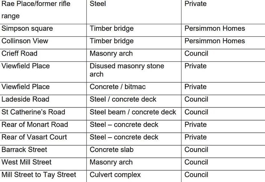
Savills (on behalf of Pilkington Trust and Stewart Milne Group)                                      March 2021
Almond Valley- Phase 1 Application; Habitats Regulations Appraisal

2 METHODS

2.1         The Habitats Regulations Appraisal Process
The Habitats Regulations Appraisal is a four-stage process with specific issues and tests outlined at each stage.
An important aspect of the process is that the outcome at each successive stage determines whether a further
stage in the process is required. The stages are summarised in Table 2-1.

Table 2-1 Key Stages in the HRA Process
 Stage 1
 Screening for Likely     - Identify international sites in and around the project area.
 Significant Effect       - Examine conservation objectives of the interest feature(s) (where available).
 (LSE)                    - Review plan policies and proposals and consider potential effects on Natura 2000
                            sites (magnitude, duration, location, extent).
                          - Examine other plans and programmes that could contribute to ‘in combination’
                            effects.
                          - If no effects likely – report no likely significant effect.
                          - If effects are judged likely or uncertainty exists – the precautionary principle
                            applies, proceed to Stage 2.
                          - If following screening the policies are reviewed and include sufficient mitigation
                            which will ensure no likely significant effects, then no further AA will be needed.
 Stage 2
 Appropriate              - Complete additional scoping work including the collation of further information on
 Assessment (AA)            sites as necessary to evaluate impact in light of conservation objectives.
                          - Agree scope and method of AA with the competent authority.
                          - Consider how the project ‘in combination’ with other projects will interact when
                            implemented (the AA).
                          - Consider how effects on integrity of the site could be avoided by changes to the
                            project and the consideration of alternatives.
                          - Develop mitigation measures (including timescale and mechanisms).
                          - Report outcomes of AA including mitigation measures.
                          - If the project will not adversely affect European site integrity proceed with plan
                            but ensure that policies are monitored.
                          - If effects or uncertainty remain following the consideration of alternatives and
                            development of mitigation proceed to Stage 3.
 Stage 3
 Alternative              - Consider alternative solutions, delete from project or modify.
 Solutions                - Consider if priority species/habitats affected- identify ‘imperative reasons of
                            overriding public interest’ (IROPI), economic, social, environmental, human health,
                            public safety (only applicable in highly exceptional circumstances).
 Stage 4
 Imperative Reasons       - Stage 4 is the main derogation process of Article 6(4) which examines whether
 of Overriding Public       there are imperative reasons of overriding public interest (IROPI) for allowing a
 Interest (IROPI)           plan or project that will have adverse effects on the integrity of a Natura 2000 site
                            to proceed in cases where it has been established that no less damaging
                            alternative solution exists.
                          - The extra protection measures for Annex I priority habitats come into effect when
                            making the IROPI case. Compensatory measures must be proposed and assessed.
                            The Commission must be informed of the compensatory measures. Compensatory
                            measures must be practical, implementable, likely to succeed, proportionate and
                            enforceable, and they must be approved by the Minister.

                                                                                                                    4
Savills (on behalf of Pilkington Trust and Stewart Milne Group) March 2021
Almond Valley- Phase 1 Application; Habitats Regulations Appraisal
2.2 Screening
With reference to the SNH Guidance1 (SNH, 2015) the screening stage determines whether AA is required, by:
Determining whether a project (or plan) is directly connected with or necessary to the conservation
management of any European sites;
Describing the details of the project (or plan) proposals and other projects that may cumulatively
affect any European sites;
Describing the characteristics of relevant European sites; and
Appraising likely significant effects of the proposed project on relevant European sites.
The SNH guidance provides the following definition of LSEs:
“The test of significance is where a plan or project could undermine the site’s conservation objectives. The
assessment of that risk (of ‘significance’) must be made in the light, amongst other things, of the characteristics
and specific environmental conditions of the site concerned.”
“A likely effect is one that cannot be ruled out on the basis of objective information. The test is a ‘likelihood’ of
effects rather than a ‘certainty’ of effects. Although some dictionary definitions define ‘likely’ as ‘probable’ or
‘well might happen’, in the Waddenzee case the European Court of Justice ruled that a project should be subject
to Appropriate Assessment “if it cannot be excluded, on the basis of objective information, that it will have a
significant effect on the site, either individually or in combination with other plans and projects”. Therefore,
‘likely’, in this context, should not simply be interpreted as ‘probable’ or ‘more likely than not’, but rather
whether a significant effect can objectively be ruled out.”
2.3 Appropriate Assessment
The AA establishes whether or not a project’s LSE identified during the screening stage will have an adverse
effect on the integrity of the affected site with regard to its conservation objectives. Based on the guidance
provided by SNH (2015), the effects of the proposal on the designated sites’ qualifying features will determined
by:
Gathering information required to assess impacts (from site documents, scientific literature, EU and
UK guidance on impact assessment and impact assessments from similar projects);
Predicting the type and nature of impacts e.g. direct or indirect, short or long term;
Assessing whether there will be adverse effects on the integrity of the site as defined by the
conservation objectives and the status of the site. The precautionary principle must be applied at this
stage. If it cannot be demonstrated with supporting evidence that there will be no adverse effects
then adverse effects will be assumed; and
Ascertaining if it is possible to mitigate adverse effects.
1 https://www.nature.scot/sites/default/files/2019-07/Habitats%20Regulations%20Appraisal%20of%20Plans%20-%20plan-
making%20bodies%20in%20Scotland%20-%20Jan%202015.pdf (accessed 03/12/2019)
5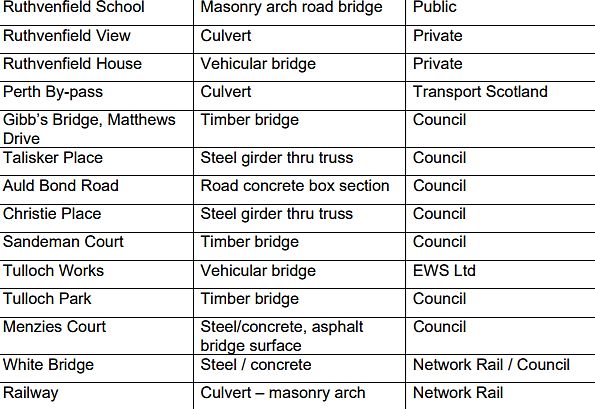
Savills (on behalf of Pilkington Trust and Stewart Milne Group) March 2021
Almond Valley- Phase 1 Application; Habitats Regulations Appraisal
3 DESCRIPTION OF PROPOSED DEVELOPMENT
3.1 Site Location
The site is located south of the River Almond in Huntingtowerfield, Perth at Ordnance Survey Grid Reference
(OSGR) NO 07707 25740. The site is dominated by arable fields. Woodland is present in the west of the site
with scattered trees along the north boundary and in the south east of the site. Areas of hardstanding are
present in the north, west and south of the site. Two small water courses are present within the south of the
site.
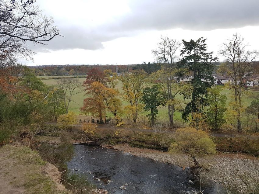
The Perth Town Lade runs through the site. The Lade runs for some 4.5 miles from a weir known as Low’s Work
on the River Almond by Huntingtower, through Tulloch estate and onwards to Perth city centre, where it exits
into the River Tay by Perth Bridge (Figure 3-1).
Figure 3-1 Perth Lade
The ‘site’ (containing the local centre and the school site) is defined as the area demarcated by the red line site
boundary as shown in Figure 3-2, Site Location Plan.
6Savills (on behalf of Pilkington Trust and Stewart Milne Group) March 2021
Almond Valley- Phase 1 Application; Habitats Regulations Appraisal
3.2 Development Description
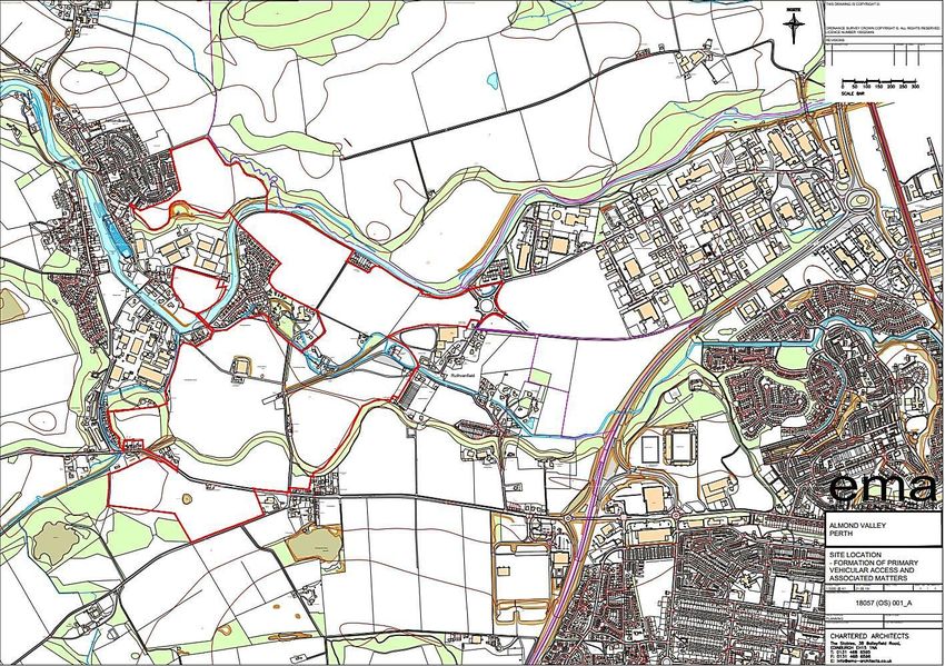
The proposed primary access route will run from the Western Link roundabout in the north-east to the A85 in
the south-west. The surveyed section referred to in this report is approximately 800m long and runs from the
A85 road at the south of the site, northwards to the school site (Figure 3-2). It follows an existing minor road
for much of the route, with two short sections crossing arable fields. The roads are bounded by fences,
hedgerows and walls.
The original application submissions in August 2019, comprised of a detailed AMSC for Phases 1 and 1A of the
development on this site (application reference 19/01433/AMM) and a detailed AMSC for the ‘primary
vehicular access’ (application reference 19/01430/AMM) included new elements that were not part of the
original application (15/01157/IPM) which was granted planning permission in principle by the Reporter in
September 2017. These differences involved culverting and realigning sections of the Perth Lade in two places
and the construction of a new road on an embankment cutting through the green corridor of the Lade (Figures
3-3 to 3-5).
As a result a 2019 HRA was undertaken which assessed the road layout as detailed in the Bayne Stevenson
Associated Ltd. “Road Layout Sheet 2 of 3” Drawing J3093-001 Rev E, dated 10.09.19 (as shown in Figure 1 and
enclosed). This road layout involved re-routing of the Perth Town Lade (referred to as Lade B in the Drawing) at
two locations as highlighted in Figure 1.
Figure 3-2: Road alignment assessed in 2019 HRA with blue circles highlighting the two proposed sections of Lade
re-routing
7Savills (on behalf of Pilkington Trust and Stewart Milne Group) March 2021
Almond Valley- Phase 1 Application; Habitats Regulations Appraisal
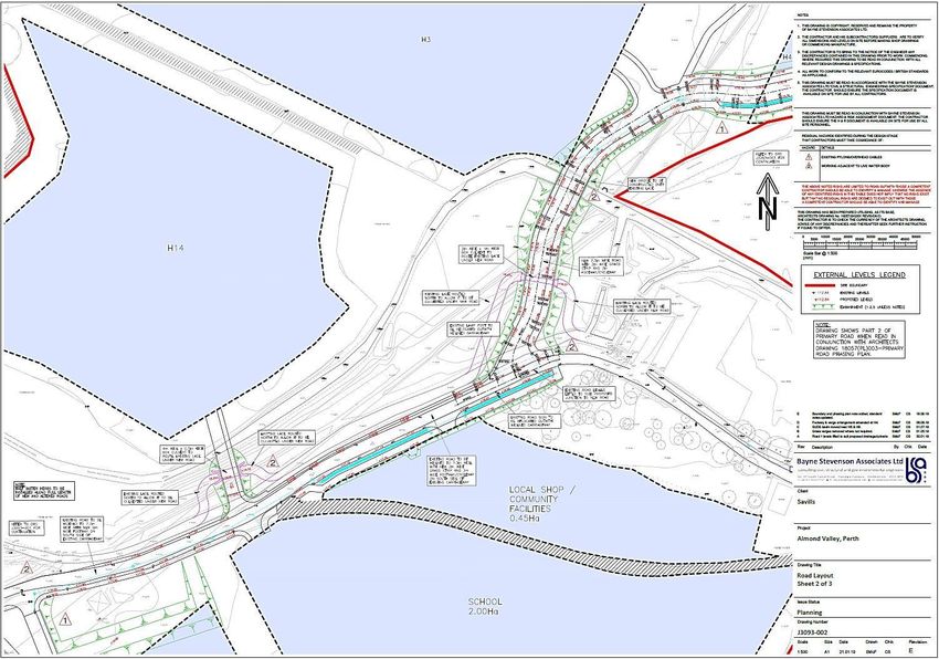
However, in the spring of 2020, Envirocentre were made aware of design proposal changes which would affect
the conclusions of the 2019 HRA. An update to the HRA was therefore issued in May 2020.
The proposed changes related to the alignment of the primary route. In particular, the changes removed the
requirement to re-route Lade B as the road crossed directly over the existing alignment of Lade B (as shown in
Bayne Stevenson Associated Ltd. “Road Layout Sheet 2 of 3” Drawing J3093-001 Rev F, dated 27.02.20) (as shown
in Figure 2 and enclosed). As a result, although the need to divert the Lade B was removed, it was still necessary
to cross the Lade B in two additional locations when compared with the initial Planning Permission in Principle
consent. The type, size and length of the actual road crossings at Lade B remained unchanged to that assessed in
the 2019 HRA.
At March 2021, there has been a further minor amendment which is to introduce new cycle bridges over the
Lade. Figure 3-3 below shows that one crossing is to the north (centre of drawing adjacent to red line boundary),
a second is to the east (again adjacent to red line boundary) and the final cross is to the south (bottom left of
drawing). One additional box culvert is required to allow the northern bridge to be installed
Figure 3-3: Revised road alignment without any Lade re-routing and with addition of active travel links.
While the Perth Lade itself is not within the River Tay SAC boundary, the lamprey and salmon which use the
Lade are part of the SAC populations. Consequently, this new element in the plan should be assessed to
establish that there will be no adverse impact on the integrity of the River Tay SAC.
8Savills (on behalf of Pilkington Trust and Stewart Milne Group) March 2021
Almond Valley- Phase 1 Application; Habitats Regulations Appraisal
Figure 3-4 Location Plan
9Savills (on behalf of Pilkington Trust and Stewart Milne Group) March 2021
Almond Valley- Phase 1 Application; Habitats Regulations Appraisal
Figure 3-5 Original Application Submission 2019: Road Layout (1)
10Savills (on behalf of Pilkington Trust and Stewart Milne Group) March 2021
Almond Valley- Phase 1 Application; Habitats Regulations Appraisal
Figure 3-6 Original Application Submission 2019: Road Layout (2)
11Savills (on behalf of Pilkington Trust and Stewart Milne Group) March 2021
Almond Valley- Phase 1 Application; Habitats Regulations Appraisal
Figure 3-7 May 2020 Primary Route Design Layout Update
12Figure 3-8 Road Layout Update with active travel links
133.3.1 In-combination Effects
Other projects within the area which could give rise to in-combination effects are:
1. Bertha Park
Description: Mixed-use development on the north bank of the River Almond, north-northeast of the
application site. The masterplan planning documents are available from the PKC planning portal
(http://planningapps.pkc.gov.uk/)
Construction Timetable: Expected to take 20-30 years to complete
2. A85/A9 Bertha Park Link Road
To the east of the Almond Valley site the A85/A9 Bertha Park Link Road works also included the provision of a
new grade separated interchange between the A9 and the A85. The Perth Lade has been diverted through new
culverts. The old section of the Lade was electro fished with a small number of Salmon and Lamprey being
discovered and translocated back into the water course downstream2.
As such, the proposals currently being considered at Almond Valley are not unique within the area.
3. Cross Tay Link Road
Description: New route for vehicles travelling through Perth. It will connect the A9 just north of Perth to the
A94 northeast of Perth and will include a new crossing over the Tay
Construction Timetable: Further to the completion of the Stage 2 Report, the specimen design of the CTLR
commenced in July 2017. The estimated programme for delivery of this phase is summarised as follows:
Design completed by mid-2019
Planning application submitted by late-2019
Procurement of main construction contract during 2020
Works commence during 2021
Works completed during 2024
4. Lade Structures
It should be noted that there are 39 structures over the Perth Lade; some of which are private (Table 3-1). As
stated within the Perth Lade Management Plan 2011 – 2031, all road bridges, footbridges and culverts that
cross over or carry the lade are subject to general inspections at least every 2 years, with principal inspections
(more detailed) every 6 years. These inspections highlight any routine maintenance works and/or any
structural problems that require attention. The structures associated with this development will be subject to
the same inspection regime.
2 Perth Tranport Futures Project, Phase 1 - A9/A85 Junction Improvement and Link Road to Bertha Park, Newsletter (Winter
2017)
14Table 3-1 Perth Lade Structures
15Source: Perth Lade Management Plan 2011 – 2031
164 SCREENING FOR LIKELY SIGNIFICANT EFFECTS
4.1 Relevant European Sites
With reference to the ‘Report to inform the Habitat Regulations Appraisal’ (Chapter 11 of the Environmental
Statement submitted in support of with the original application (15/01157/IPM)) the proposed development
has the potential to affect the River Tay SAC, as the Perth Town Lade, flows into the River Tay SAC which is
designated for a variety of habitat and species interests.
Annex I habitats present as a qualifying feature, but not a primary reason for selection of this site:
‘Clear water lakes or lochs with aquatic vegetation and poor to moderate nutrient levels (Oligotrophic to
mesotrophic standing waters with vegetation of the Littorelletea uniflorae and/or of the Isoëto-
Nanojuncetea)’
This Annex I habitat is comprised oligotrophic and mesotrophic waters, and, in some cases may also include
intergrading types. While each supports a characteristic plant community, the dominant substrates of both
oligotrophic and mesotrophic waters are silt, sand, gravel, stones and boulders
Annex II species that are a primary reason for selection of this site:
Atlantic salmon (Salmo salar)
The JNCC website states that the River Tay supports a high-quality Atlantic salmon Salmo salar population, with
rod catch returns showing that the Tay is consistently one of the top three salmon rivers in Scotland. In 1999
the catch was 7230 fish, over 10% of the Scottish total. The Tay drains a very large catchment, and has the
greatest flow of all UK rivers. There is considerable ecological variety in the Tay catchment, resulting in the Tay
supporting the full range of salmon life-history types found in Scotland, with adult salmon entering the River
Tay throughout the year to spawn in different parts of the catchment 3.
Annex II species present as a qualifying feature, but not a primary reason for site selection
Brook lamprey (Lampetra planeri);
River lamprey (Lampetra fluviatilis); and
Sea lamprey (Petromyzon marinus);
Otter (Lutra lutra).
The potential effects of the proposed works include habitat loss and severance, pollution, hydrological impacts
and specific effects on qualifying interests from the construction activities which involve culverting and
realignment of sections of the Perth Lade in two places and the construction of a new road on an embankment
cutting through the green corridor of the Lade. These are new elements that were not part of the original
application (15/01157/IPM) which was granted planning permission in principle by the Reporter in September
2017, and as such SNH has requested that they now be appraised.
A further two Natura 2000 sites occur within 10 km of the application site:
Methven Moss SAC is designated for bog habitat. It is located c.5.5 km upstream of the site (in a west-
south westerly direction) and the designated habitat is therefore not subject to likely significant
effects.
3 https://sac.jncc.gov.uk/site/UK0030312 (accessed 22/11/2019)
17 South Tayside Goose Roosts SPA and Ramsar wetland is designated for wintering pink-footed goose
(Anser brachyrhynchus) and greylag goose (Anser anser), and the SPA is also designated for its
wintering waterfowl assemblage. The SPA and Ramsar wetland is located c.6.0 km southwest of the
application site. Although qualifying species may forage outside the designated area, they are very
unlikely to enter the application site, owing to the high amount of residential and industrial
development characterising the site and adjacent areas relative to less developed farmland in the
wider area. The qualifying species are therefore not subject to likely significant effects.
As they are not subject to likely significant effects, these two sites were not considered any further.
4.2 Zone of Influence for the Proposed Development
For significant effects to arise, there must be a risk enabled by having a 'source' (e.g. construction works at a
proposed development site), a 'receptor' (e.g. a European site or its qualifying interests), and a pathway
between the source and the receptor (e.g. mobile marine species travelling between the proposed
development site and the designated site). The identification of a pathway does not automatically mean that
significant effects will arise. The likelihood for significant effects will depend upon the characteristics of the
source (e.g. duration of construction works), the characteristics of the pathway (e.g. what species and the
number of individuals travelling between the two sites) and the characteristics of the receptor (e.g. the
sensitivities of the European site and its qualifying interests).
18Savills (on behalf of Pilkington Trust and Stewart Milne Group) March 2021
Almond Valley- Phase 1 Application; Habitats Regulations Appraisal
Table 4-1 River Tay SAC with Their Qualifying Features and Screening Assessment for Likely Significant Effects
Site Name Conservation Objectives Qualifying Features Likely Significant Effect (LSE) Screening
Assessment
River Tay Qualifying Habitat Conservation Clear-water lakes or No pathway for LSE identified Screened out
SAC lochs with aquatic
To avoid deterioration of the qualifying habitat thus With reference to Report to inform the Habitat Regulations Appraisal’ (Chapter 11 of the Environmental Statement submitted in
ensuring that the integrity of the site is maintained and vegetation and poor support of with the original application (15/01157/IPM)) clear water lochs with aquatic vegetation and poor to moderate nutrient
the site makes an appropriate contribution to achieving to moderate nutrient levels only occur upstream of the application site and are therefore not subject to likely significant effects.
favourable conservation status for each of the qualifying levels
features; and
To ensure for the qualifying habitat that the following
are maintained in the long term:
o Extent of the habitat on site
o Distribution of the habitat within site
o Structure and function of the habitat
o Processes supporting the habitat
o Distribution of typical species of the habitat
o Viability of typical species as components of the
habitat
o No significant disturbance of typical species of the
habitat
Qualifying Species Conservation Annex II species Pathway for LSE identified. Potential Impacts
To avoid deterioration of the habitats of the qualifying Otter A protected Species Survey of the site was undertaken in October 2018, and the access route was added to the site boundary and - Screened In
species (listed below) or significant disturbance to the subsequently surveyed in April 2019.
(Lutra lutra)
qualifying species, thus ensuring that the integrity of the
Otter spraints were identified along the River Almond, adjacent to the north boundary of the site. No otter resting places were
site is maintained and the site makes an appropriate
identified during the survey. Suitable habitat for resting, foraging and commuting exists within and adjacent to the site for otter. The
contribution to achieving favourable conservation status
Town’s Lade may provide some additional foraging and commuting opportunities for otter.
for each of the qualifying features; and
to ensure for the qualifying species that the following are Water pollution causing toxicity events on otter, either directly or indirectly through the food chain.
maintained in the long term:
Light spillage onto Perth Lade during construction and operation – could lead to behavioural changes or avoidance of key habitat
Population of the species, including range of genetic
Potential habitat loss.
types for salmon, as a viable component of the site
Distribution of the species within site Potential habitat fragmentation between feeding and shelter habitat.
Distribution and extent of habitats supporting the Potential removal of safe passage up and down Perth Lade.
species
Structure, function and supporting processes of Potential loss of couches and holts.
habitats supporting the species Potential disturbance to habitat and / or food chain.
No significant disturbance of the species
Road traffic strikes as a result of the construction of a new road
Annex II species Pathway for LSE identified. Potential Impacts
Potential for Atlantic salmon to be impacted by accidental pollution incidents during construction or increased sedimentation or - Screened In
Atlantic salmon
turbidity as a result of construction.
(Salmo salar)
Potential physical barriers to movement or migration from new temporary or permanent structures.
Potential noise disturbance – could lead to hearing damage, behavioural changes or avoidance of key habitat.
Potential disturbance to the spawning areas of qualifying species.
Annex II species Pathway for LSE identified. Potential Impacts
Brook lamprey The proposal could cause direct harm to lamprey spawning gravels from the impacts of sediment laden run-off during construction and - Screened In
(Lampetra planeri) operation of the site from surface water run-off; and from the discharge of wastewater from the development into Perth Lade during
operation.
19Savills (on behalf of Pilkington Trust and Stewart Milne Group) March 2021
Almond Valley- Phase 1 Application; Habitats Regulations Appraisal
Potential physical barriers to movement or migration from new temporary or permanent structures.
Potential noise disturbance – could lead to hearing damage, behavioural changes or avoidance of key habitat.
Potential disturbance to the spawning areas of qualifying species.
Annex II species Pathway for LSE identified. Potential Impacts
River lamprey The proposal could cause direct harm to lamprey spawning gravels from the impacts of sediment laden run-off during construction and - Screened In
(Lampetra fluviatilis) operation of the site from surface water run-off; and from the discharge of wastewater from the development into Perth Lade during
operation
Potential physical barriers to movement or migration from new temporary or permanent structures.
Potential noise disturbance – could lead to hearing damage, behavioural changes or avoidance of key habitat.
Potential disturbance to the spawning areas of qualifying species.
Annex II species Pathway for LSE identified. Potential Impacts
Sea lamprey The proposal could cause direct harm to lamprey spawning gravels from the impacts of sediment laden run-off during construction and - Screened In
(Petromyzon operation of the site from surface water run-off; and from the discharge of wastewater from the development into Perth Lade during
marinus) operation
Potential physical barriers to movement or migration from new temporary or permanent structures.
Potential noise disturbance – could lead to hearing damage, behavioural changes or avoidance of key habitat.
Potential disturbance to the spawning areas of qualifying species.
20Savills (on behalf of Pilkington Trust and Stewart Milne Group) March 2021
Almond Valley- Phase 1 Application; Habitats Regulations Appraisal
5 APPROPRIATE ASSESSMENT
The requirement to undertake an Appropriate Assessment (AA) is triggered when it is determined that a plan
or project is likely to have a significant effect on a European site either alone or in-combination with other
plans or projects. Guidance issued SNH4 states that the purpose of an AA is to determine whether adverse
effects on the integrity of the site can be ruled out as a result of the plan or project, either alone or in-
combination with other plans and projects, in view of the site’s conservation objectives.
The purpose of this AA is to determine whether or not adverse effect on integrity of those sites and features
identified during the likely significant effects test can be ruled out as a result of the Project alone or in-
combination with other plans and projects in view of the site’s conservation objectives.
5.1 Clear water lakes or lochs with aquatic vegetation and poor to moderate
nutrient levels (Oligotrophic to mesotrophic standing waters with vegetation
of the Littorelletea uniflorae and/or of the Isoëto-Nanojuncetea)
As noted within Table 4.1, the River Tay Habitat Qualifying Feature ‘Clear water lakes or lochs with aquatic
vegetation and poor to moderate nutrient levels (Oligotrophic to mesotrophic standing waters with vegetation
of the Littorelletea uniflorae and/or of the Isoëto-Nanojuncetea)’ was screened out.
5.2 Atlantic Salmon (Salmo salar) and Brook, River and Sea Lamprey (Lampetra
planeri, Lampetra fluviatilis, Petromyzoan marinus)
Atlantic salmon are an anadromous fish, meaning they migrate from the sea to freshwater to breed. Eggs are
typically laid in shallow gravel beds or ‘redds’ in rivers where young fish develop until they reach the ‘smolt’
stage. They then migrate out to sea in the spring where they will remain until they reach maturity. Once
salmon are fully developed, they return to their natal rivers to spawn.
Lampreys are primitive, jawless fish resembling eels. The river and sea lamprey are both anadromous fish,
similarly to the salmon they spend part of their life at sea and breed in freshwater. The eggs are laid in small
depressions in freshwater gravel beds with flowing water in the spring and summer months. Once the eggs
have hatched, the larvae, known as ammocoetes, move down stream and burrow in to silt beds. The larvae
remain in the silt beds, feeding, until they have matured and under gone metamorphosis. The adult fish then
migrate to tidal estuaries and the open sea.
The brook lamprey is the smallest of the lamprey found in Scotland. It is a non-migratory species, living its
entire life cycle within freshwater. The life cycle is similar to that of the other lamprey species; except that
once the larvae have metamorphosed they remain in the silt burrows. The adults do not feed and so do not
migrate to the sea.
Whilst all of the fish listed as qualifying features for the SAC are biologically different; they have similar enough
habitat requirements (clean water, gravel, silt beds) that they have been grouped together in order to consider
the effects of the proposed development on the conservation objectives.
4 Habitats
Regulations Appraisal of Plans Guidance for Plan-Making Bodies In Scotland Version 3.0 January 2015
https://www.nature.scot/sites/default/files/2019-07/Habitats%20Regulations%20Appraisal%20of%20Plans%20-%20plan-
making%20bodies%20in%20Scotland%20-%20Jan%202015.pdf (Accessed 22/11/2019)
21Savills (on behalf of Pilkington Trust and Stewart Milne Group) March 2021
Almond Valley- Phase 1 Application; Habitats Regulations Appraisal
5.2.1 Effect of the Proposed Development on Site Integrity as Defined by the Conservation
Objectives
Potential Impact: It is possible that pollutants, debris and sediments could enter the watercourse as a result of
earth works, vehicle movements, inappropriate material storage and waste disposal etc. associated with work
to realign the Perth lade and construction of a new road on an embankment cutting through the green corridor
of the Lade. This could result in short term disturbance, injury or death to fish either directly or indirectly
through effects on the habitat.
All of the fish species listed as qualifying features are at risk from pollution and sediment deposition. The eggs
laid in gravel beds are at particular risk from sediment deposition as they require well oxygenated water.
Excess sediment will smother and kill the eggs. Pollution can also become a barrier to mature adults migrating
upstream to spawn. If sediment or other pollutants entered the watercourse during the construction phase the
effects on the fish populations would therefore likely last for the duration of the construction period and up to
one year after as the current years eggs would be impacted and the following year’s eggs would not be laid if
the adults could not reach the spawning sites.
Any potential impacts from material released during the construction phase and realignment of the Perth Lade
will be avoided through the mitigation outlined in section 7.
Potential Impact: It is possible that the realignment of Perth Lade and construction of culverts and a new road
on an embankment cutting through the green corridor of the Lade could result in changes to the water flow
and sediment deposition for the lifetime of the development. This could result in longer term disturbance or
death to fish either directly or indirectly through effects on the habitat.
Culverts could obstruct or delay fish passage unless the depths and velocities of flow in them are within the
swimming capabilities of the species to be catered for.
Works could create water pollution through:
Sedimentation - impacts include smothering fish eggs and causing mortalities in fish of all ages,
reducing abundance of food and impeding movement of fish.
Cement, grout and concrete - toxic to fish.
Oil and fuels - direct impacts on fish, fish food and fish habitats.
The removal of bed material could cause loss of instream vegetation, food and may destroy spawning or
nursery habitats.
Disturbance of riparian vegetation Loss of shelter and cover, loss of food (plant debris and vegetation
invertebrates).
Any potential impacts from material released during the construction phase and changes to the water flow and
sediment deposition of the Perth Lade will be avoided by implementing the mitigation outlined in section 7.
5.3 Otter
5.3.1 Species Description
The otter is a semi-aquatic mammal, which occurs in a wide range of ecological conditions, including inland
freshwater and coastal areas. Populations in coastal areas utilise shallow, inshore marine areas for feeding but
also require fresh water for bathing and terrestrial areas for resting and breeding holts. Coastal otter habitat
ranges from sheltered wooded inlets to more open, low-lying coasts. Inland populations utilise a range of
22Savills (on behalf of Pilkington Trust and Stewart Milne Group) March 2021
Almond Valley- Phase 1 Application; Habitats Regulations Appraisal
running and standing freshwaters. These must have an abundant supply of food (normally associated with high
water quality), together with suitable habitat, such as vegetated river banks, islands, reedbeds and woodland,
which are used for foraging, breeding and resting.
Persecution, habitat loss and, more recently, the impact of toxic organochlorine insecticides caused a marked
reduction in the range of the species. At present, the majority of the otter population in Great Britain occurs in
Scotland, with a significant proportion of this number being found in the north and west of the country.
5.3.2 Effect of the Proposed Development on Site Integrity as Defined by the Conservation
Objectives
Potential Impact: it is possible that noise and vibrations from vehicles and equipment, and additional lighting
used during construction and realignment of the Pert Lade may cause short term disturbance to otter.
The mitigation outlined in section 7 will reduce the risk of disturbance to otters occurring as a result of the
construction works. Any disturbance which does occur will be temporary in nature and will only affect otter
within the immediate vicinity of the development. Given the mobility of otters, the large territories they cover
and the mitigation which will be in place, the construction of the development will not adversely affect the
conservation objectives for otters within the River Tay SAC.
Potential Impact: if pollutants, debris and sediments enter the watercourse otter could be disturbed indirectly
in the short term through effects on their food source (e.g. fish).
As described in section 5.2.2, impacts on fish and their habitat are not anticipated during construction of the
culverts or realignment of the Perth Lade due to mitigation. In particular the employment of standard good
practice pollution prevention controls including; Guidance for Pollution Prevention (GPP) 5: Works and
maintenance in or near water, GPP6: Working at construction and demolition sites and GPP 21: Pollution
Incident Response Plans, will prevent any materials from entering the water course. No adverse effects on the
conservation objectives for otter are therefore anticipated
Potential Impact: increased utilisation of the watercourse by people and domestic animals such as dogs from
the new housing could result in otter disturbance and altered distribution within the SAC in the longer term.
The planned greenspace planting between the Perth Lade and the housing development will create a screen
between the water course and the residential area. Disturbance as a result of increased use of the water
course will therefore not adversely affect the conservation objectives for otter within the SAC.
23Savills (on behalf of Pilkington Trust and Stewart Milne Group) March 2021
Almond Valley- Phase 1 Application; Habitats Regulations Appraisal
6 IN-COMBINATION EFFECTS
Bertha Park
The scheme will take place simultaneously with the proposed development and will take 20-30 years to
complete. There is a potential for in-combination effects on salmon and lamprey, because the Bertha Park
scheme will drain into the River Almond through SUDS outfalls. As such, there is also a potential for indirect
effects on otters through an effect on prey species.
Cross Tay Link Road
There is a potential for in-combination effects on otter, salmon and lamprey interests
A9/A85 Crieff Road Junction Redevelopment
There is a potential for in-combination effects on salmon and lamprey from the construction in and near the
aquatic environment, including from construction of both the crossing and the SUDS. As such, there is also a
potential for indirect effects on otters through an effect on prey species.
Conclusion
Given the relatively large scale of these schemes and their concentration in the local area, it is considered that
there is potential for in-combination effects on the integrity of the River Tay. It is recommended that a
Construction Environmental Management Plan be prepared to minimise any potential for in-combination
effects.
24You can also read